Drone Thermal Imaging Survey UK: The Professional Guide to Aerial Thermography

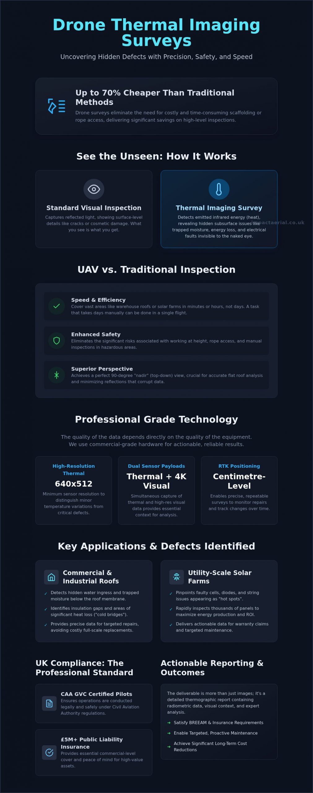
Did you know that professional drone surveys can be up to 70% cheaper than traditional inspection methods like scaffolding or rope access? For many commercial property managers and solar farm operators, the primary concern isn’t just the cost of access; it’s the invisible energy leaks and structural defects that remain hidden until they cause expensive downtime. You need a reliable way to inspect high-level assets without compromising on safety or risking the use of uncertified, under-insured pilots.

This guide explains how a drone thermal imaging survey UK identifies hidden moisture, energy loss, and solar faults with surgical precision. We’ll explore how CAA GVC certified pilots utilize commercial-grade DJI Enterprise hardware to deliver actionable thermographic data that satisfies both BREEAM and insurance requirements. You will learn how to secure a detailed, compliant report that provides the technical reassurance and long-term cost savings your business demands.

Key Takeaways

  • Learn how non-destructive infrared sensors detect heat signatures and hidden defects invisible to the human eye from a safe distance.
  • Understand why high-resolution sensors and commercial-grade DJI Enterprise hardware are essential for capturing accurate, actionable thermal data.
  • Discover how a drone thermal imaging survey UK identifies specific issues like water ingress in commercial roofs and ‘hot spots’ on utility-scale solar farms.
  • Identify the critical legal requirements, including CAA GVC certification and £5m liability insurance, necessary for compliant professional aerial inspections.
  • Find out how detailed thermographic reporting provides the precise insights required for BREEAM compliance and significant long-term maintenance cost reductions.

What is a Drone Thermal Imaging Survey?

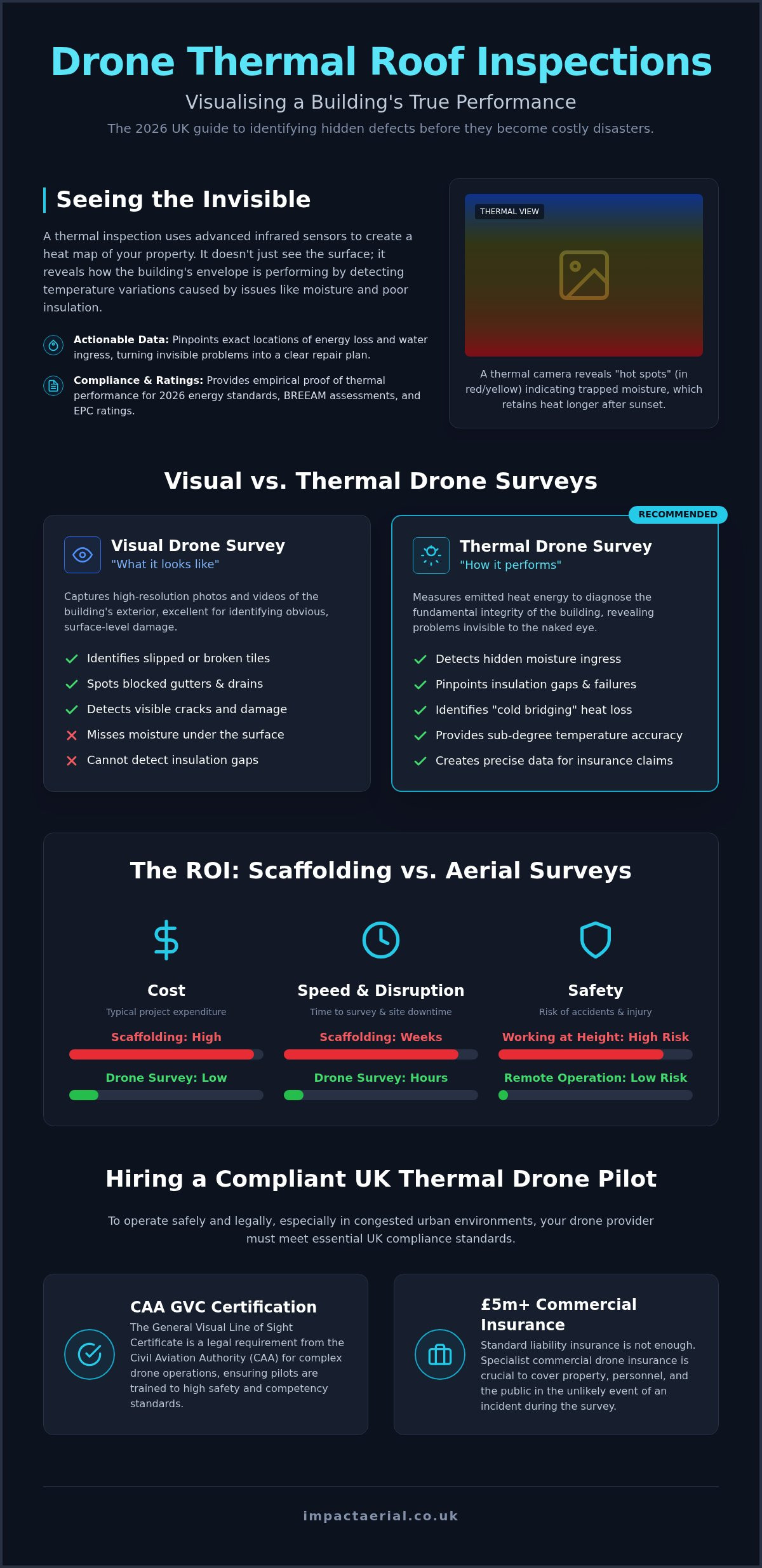
A drone thermal imaging survey UK is a specialized, non-destructive inspection method that utilizes Unmanned Aerial Vehicles (UAVs) equipped with high-resolution infrared sensors. Unlike standard photography, which captures the light reflected off a surface, thermal imaging detects the infrared radiation emitted by an object. This technology allows surveyors to visualize temperature variations across a structure, identifying anomalies that indicate underlying issues such as trapped moisture, insulation gaps, or electrical faults. It’s an essential tool for commercial property managers who require a comprehensive overview of their assets without the downtime associated with physical inspections.

The core benefit of this technology is its ability to detect heat signatures that are entirely invisible to the human eye. In a commercial context, this might reveal a “hot spot” on a solar panel or a “cold bridge” in a building’s envelope where heat is escaping. By capturing this data from a safe distance, drones eliminate the need for costly scaffolding or risky manual inspections at height. It isn’t just about taking pictures; it’s about gathering precise, technical data that informs long-term maintenance strategies and reduces operational risk.

There’s a significant difference between visual and thermal data. While a high-resolution visual camera can show you a crack in a roof tile, a thermal sensor reveals the damp insulation beneath it that has been festering for months. This layered approach to data collection provides a level of insight that traditional surveys simply cannot replicate, allowing for targeted repairs rather than expensive, site-wide replacements.

How Aerial Thermography Works

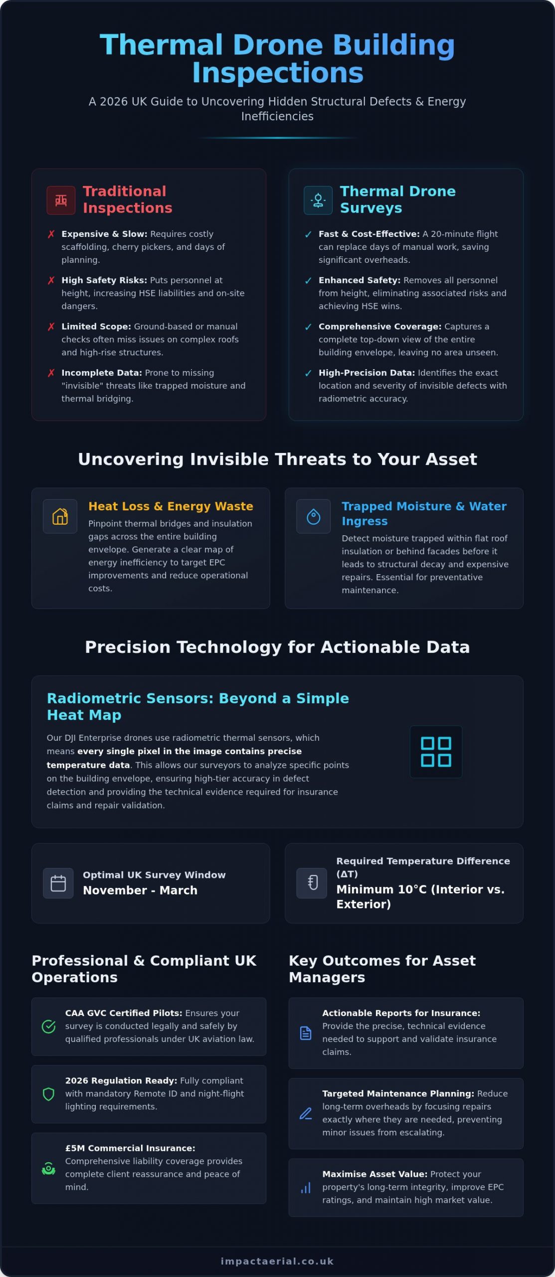
Thermal sensors convert infrared energy into a visual map known as a thermogram. Professional surveys rely on “Radiometric” data, which means the sensor records a specific temperature value for every single pixel in the image. This allows for detailed post-flight analysis where surveyors can interrogate the data to find exact temperature differentials. Accuracy depends heavily on technical calibration. Emissivity refers to the effectiveness of a material’s surface in emitting energy as thermal radiation, a variable that professional surveyors must calibrate to ensure data integrity. Without accounting for emissivity and atmospheric conditions, thermal data can be misleading or entirely inaccurate.

UAV vs. Traditional Thermal Surveys

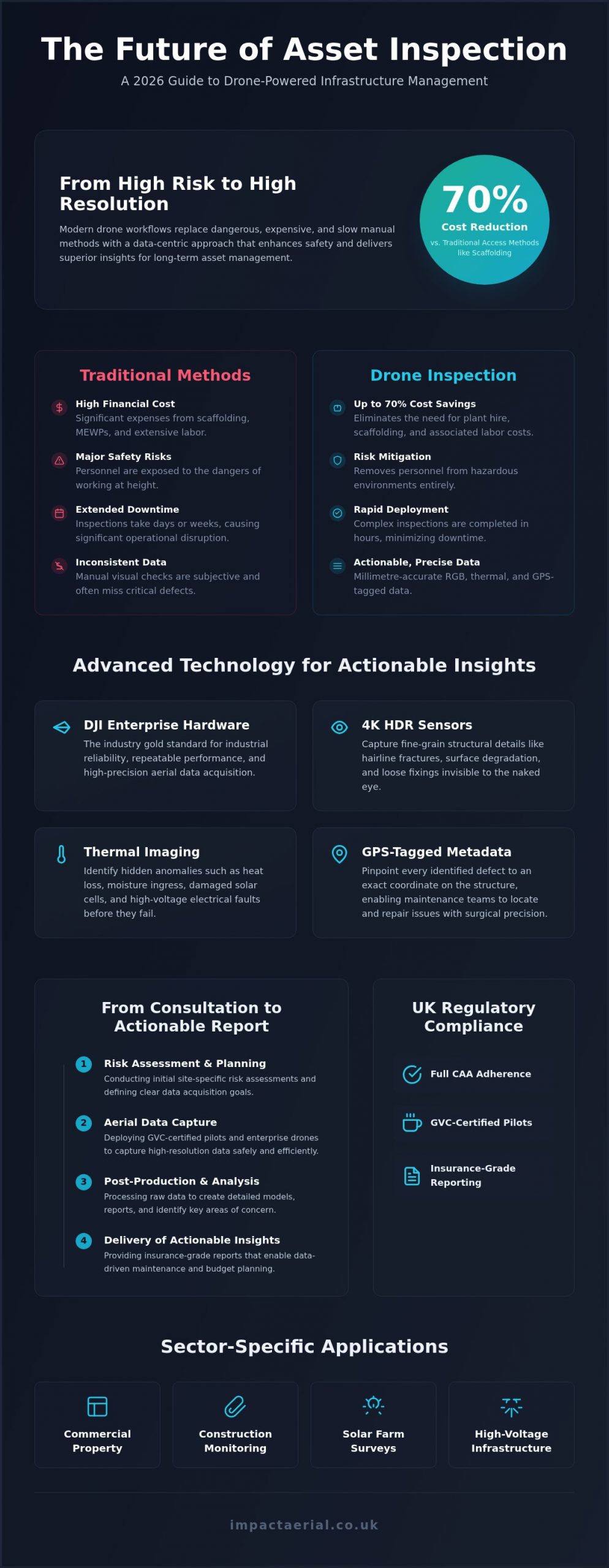
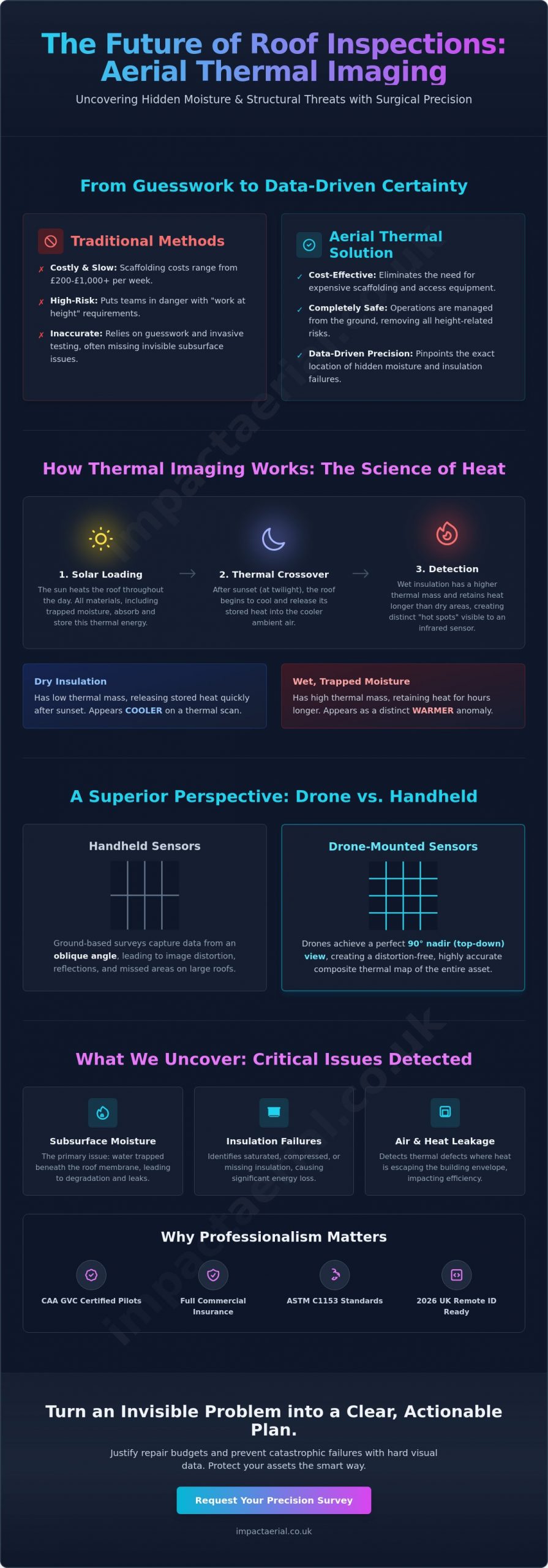
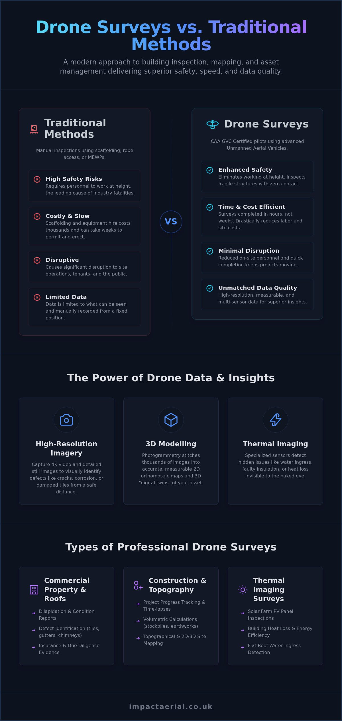
Speed is one of the most immediate advantages of a drone thermal imaging survey UK. A warehouse roof that would take a surveyor days to inspect with a handheld camera can be covered in minutes from the air. Safety is equally paramount; by using drones, we remove the necessity for rope access or working at height, significantly lowering the risk profile of the project. Furthermore, drones provide the “nadir” or straight-down perspective. This 90-degree angle is crucial for flat roof surveys to minimize reflections and ensure the sensor captures the most accurate thermal signature possible across the entire surface area.

Advanced Technology: The DJI Enterprise Advantage

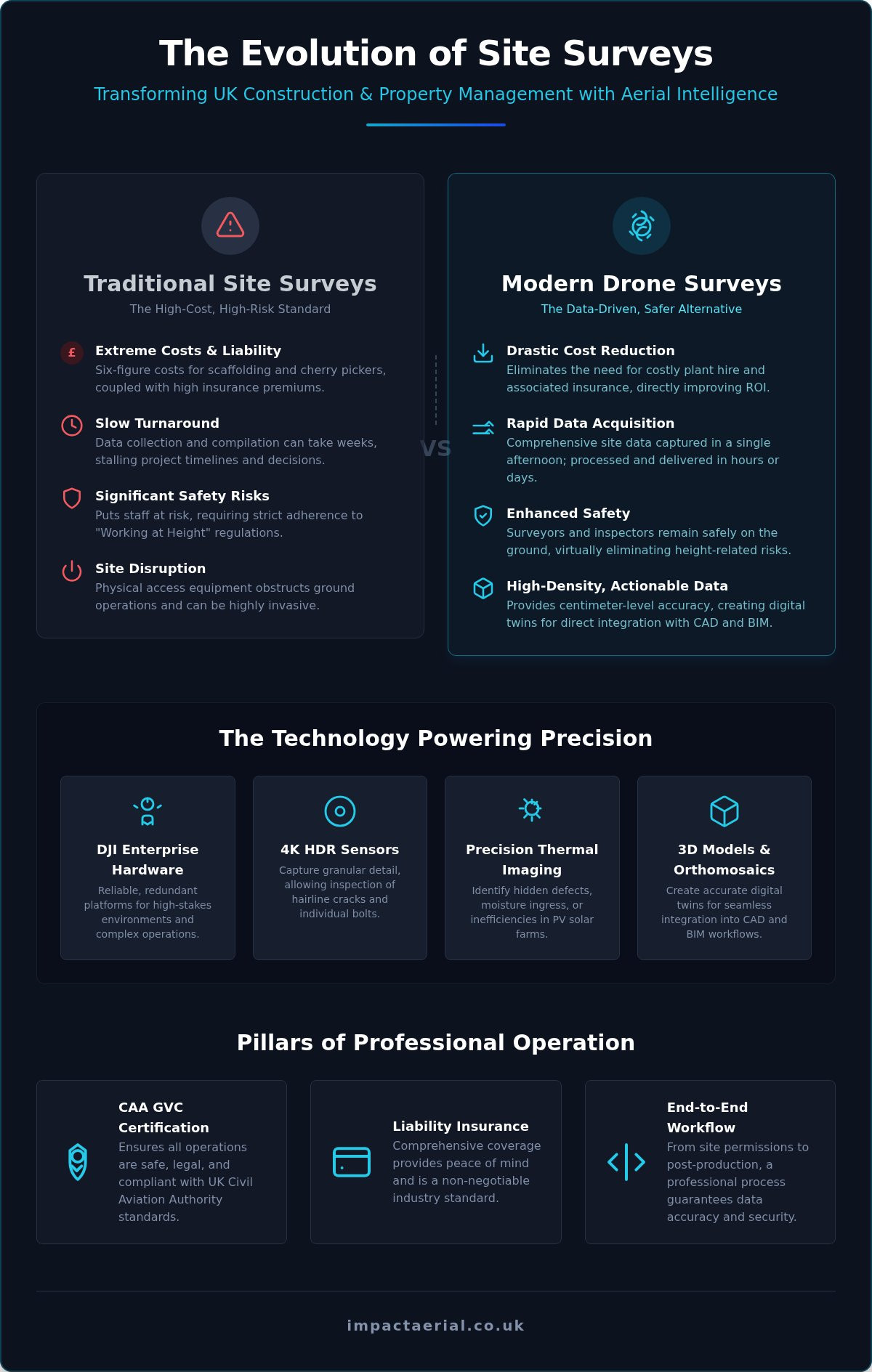
The success of a drone thermal imaging survey UK depends entirely on the caliber of the equipment used. While consumer drones might offer basic thermal capabilities, we utilize commercial-grade DJI Enterprise hardware to ensure the highest data integrity. These platforms are specifically designed for industrial applications, featuring high-resolution thermal sensors with a minimum of 640×512 resolution. This level of detail is critical; lower resolutions often fail to distinguish between minor surface temperature variations and genuine structural defects. By using professional sensors, we can identify anomalies as small as a single failing solar cell or a minor moisture leak behind a parapet wall.

Precision is further enhanced through dual-sensor capabilities and RTK (Real-Time Kinematic) positioning. Our drones capture high-resolution 4K visual imagery and thermal data simultaneously. This allows us to overlay the heat map onto a clear visual photograph, providing essential context for maintenance teams. RTK technology provides centimetre-level positioning accuracy, which is vital for repeatable surveys. If we identify a fault today, we can return to the exact coordinates months later to monitor the effectiveness of repairs. Ensuring that these advanced platforms are operated within the strict guidelines for UK Compliance, Safety, and Choosing a Provider is a core part of our operational philosophy.

The Importance of Delta T in UK Surveys

For a thermal survey to be accurate, there must be a sufficient temperature difference, known as Delta T, between the internal and external environments. In the UK, we typically require a Delta T of at least 10°C to 15°C for building envelope inspections. This makes the UK winter months and night-time operations the optimal window for survey work. Conducted after sunset, these surveys eliminate “solar loading,” where the sun warms the building surface and masks underlying defects. We carefully monitor wind speeds and surface moisture, as excessive wind can “wash away” heat signatures and rain can provide false readings due to evaporative cooling.

Radiometric Data and Reporting

Data captured during our flights is recorded in a radiometric JPEG format. This means every pixel in the image contains a specific temperature measurement that can be interrogated during post-production. Our technical team uses specialized software to analyze these heat maps, adjusting parameters like emissivity to produce a professional, actionable report. These insights are often integrated into broader drone property surveys to provide a complete digital twin of a commercial asset. If you are managing a large-scale facility, our team can help you assess your specific thermal requirements to ensure your next inspection delivers maximum value.

Drone Thermal Imaging Survey UK: The Professional Guide to Aerial Thermography

Key Applications for Drone Thermal Surveys in the UK

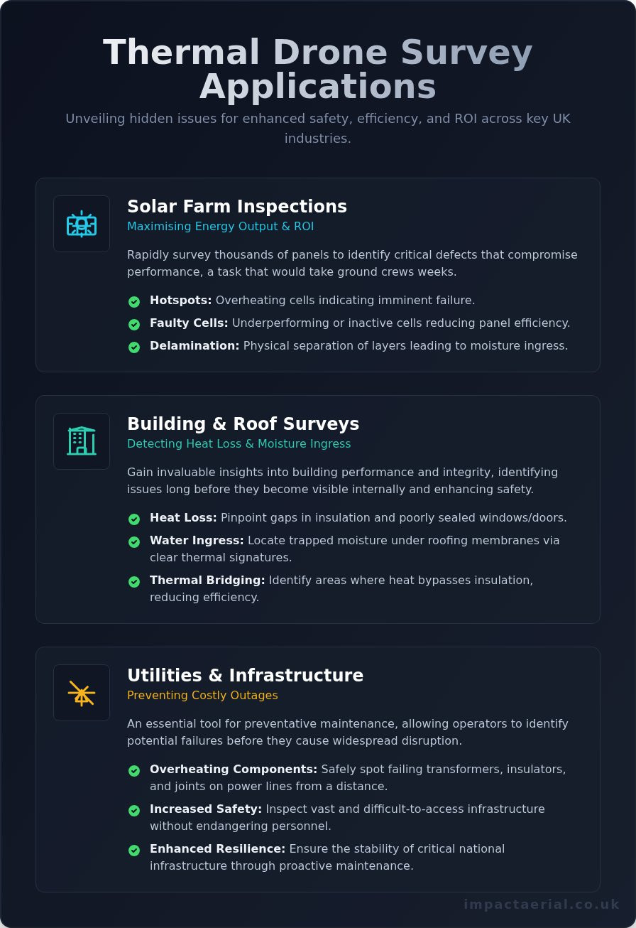
The versatility of a drone thermal imaging survey UK makes it an indispensable asset for diverse industrial sectors. From identifying energy inefficiencies in large-scale warehouses to monitoring critical infrastructure, the applications are as varied as they are vital. Operating these surveys requires strict adherence to UK Civil Aviation Authority drone regulations, particularly when navigating the complex airspaces surrounding industrial hubs or densely populated commercial zones. By integrating thermal data into standard maintenance workflows, organizations can transition from reactive repairs to a proactive, data-driven strategy.

In industrial facilities, thermal drones monitor steam pipe networks, electrical substations, and mechanical components for signs of overheating or wear. These hotspots often precede catastrophic failure, meaning a single flight could prevent thousands of pounds in lost production time. For building envelopes, thermography is a primary tool for verifying air leakage and insulation continuity, which is often required for BREEAM assessments or energy efficiency certifications. This technical oversight ensures that commercial assets remain compliant with evolving environmental standards while reducing operational overheads.

Solar Farm Efficiency and ROI

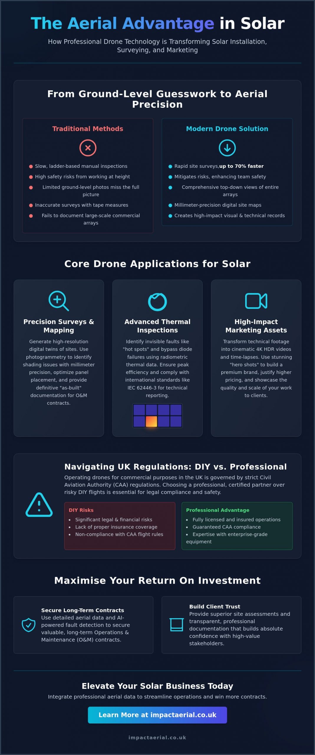
Maximizing the output of renewable assets is the primary goal of PV solar farm thermal surveys. Traditional manual testing of a utility-scale array can take weeks and involves significant labor costs. In contrast, a drone can inspect hundreds of acres in a single day, identifying bypass diode failures and string issues with absolute precision. It’s important to understand that a single faulty cell can degrade an entire string’s performance, leading to a disproportionate drop in total energy production. By pinpointing these defects early, operators can ensure their maintenance teams only replace what’s necessary, protecting the long-term ROI of the site.

Commercial Property and Flat Roofs

Flat roofs are notorious for hidden moisture entrapment, which often goes unnoticed until structural damage occurs. A drone thermal imaging survey UK identifies these wet areas by detecting the thermal mass of trapped water, which retains heat longer than dry insulation after sunset. This allows property managers to perform targeted patch repairs rather than commissioning a full roof replacement. For those looking to understand the broader context of aerial data, our drone survey guide explains how thermal data fits into a holistic asset management plan. Visualizing heat loss in this way provides the tangible evidence needed to justify energy-saving capital expenditures in large industrial warehouses.

UK Compliance, Safety, and Choosing a Provider

Compliance is the cornerstone of any professional drone thermal imaging survey UK. It isn’t merely a matter of following rules; it’s about rigorous risk mitigation and ensuring the safety of personnel and property. Every commercial flight must be preceded by a site-specific Risk Assessment and Method Statement (RAMS). These documents outline exactly how the pilot will manage hazards, from public footpaths to overhead power lines. Additionally, because thermal data can reveal sensitive information about a facility’s operations and security, professional providers must handle all data in strict accordance with UK GDPR standards.

Choosing a provider based solely on price often leads to significant legal and financial risks. A professional firm brings technical reassurance through meticulous operational standards. This includes maintaining detailed flight logs, equipment maintenance records, and up-to-date insurance certificates. When you hire an expert, you aren’t just paying for a thermal map; you’re investing in a compliant process that protects your business from liability.

Why CAA GVC Certification Matters

In the UK, the General Visual Line of Sight Certificate (GVC) is the standard legal requirement for pilots operating under an Operational Authorisation from the Civil Aviation Authority. Understanding the nuances of a drone license is vital for anyone commissioning commercial work. There’s a vast difference between a hobbyist flyer and a professional operator. Certified pilots have undergone rigorous theory and practical examinations to prove they can navigate complex UK airspace and urban environments safely. They understand how to coordinate with Air Traffic Control and other stakeholders, ensuring that your survey doesn’t interfere with local aviation activity.

Insurance and Liability

While many drone users carry basic insurance, £5m commercial liability insurance is the recognized gold standard for UK site access. Many industrial facilities, construction sites, and solar farms won’t grant gate access without proof of this specific level of indemnity. This coverage is essential because it protects the client, the public, and the property in the unlikely event of an incident. Using an under-insured or uncertified pilot exposes your organization to immense financial risk and potential breach of contract with your own insurers. Before commissioning a survey, always verify a pilot’s credentials and insurance validity. If you need a vetted partner for your next project, contact our certified team to discuss your requirements and receive a detailed safety brief.

Impact Aerial: Professional Thermal Solutions Across the UK

Based in Birmingham, Impact Aerial is strategically positioned in the West Midlands to facilitate rapid deployment for any drone thermal imaging survey UK. Our central location allows us to provide a consistent, high-tier service to commercial clients from Scotland to the South Coast. We combine the creative eye developed through years of professional aerial filming with the meticulous technical precision required for thermographic data collection. This unique blend of skills ensures that every survey we conduct isn’t just technically accurate, but also provides the visual clarity needed for stakeholders to understand complex findings quickly.

Our brand promise of reassurance and reliability is reflected in our choice to use only CAA GVC certified pilots and £5m commercial liability insurance. We don’t just provide raw data; we offer a technical partnership designed to reduce your operational risks. By handling every stage of the process in-house, we maintain total control over data quality and safety standards, giving you the peace of mind that your assets are in expert hands.

Our Survey and Reporting Process

Precision begins long before the drone leaves the ground. Our pre-flight phase involves rigorous weather monitoring and Delta T planning to ensure atmospheric conditions are optimal for thermal contrast. Once on-site, our pilots use DJI Enterprise hardware to capture radiometric data efficiently, minimizing disruption to your site operations. The most critical phase, however, is our post-production reporting. We translate complex heat maps into actionable PDF reports that feature side-by-side thermal and visual comparisons. This clear documentation allows your maintenance teams to see exactly where a defect is located in the real world, removing the guesswork from repairs and providing a verifiable audit trail for insurance or BREEAM compliance.

Book Your UK Thermal Drone Survey

Every commercial property or solar farm has unique requirements, which is why we start every project with a detailed consultation. We work with you to identify the specific questions you need the thermal data to answer, whether you’re chasing an elusive roof leak or auditing the efficiency of a utility-scale PV array. This targeted approach ensures that the final report delivers maximum value and tangible insights for your business. Our team is ready to provide a tailored quote based on your site’s scale and complexity. To secure technical reassurance for your assets, Contact Impact Aerial for a professional thermal imaging quote.

Maximise Operational Efficiency with Precision Thermography

A drone thermal imaging survey UK provides the technical clarity needed to protect commercial property and utility-scale solar farms from invisible defects. By leveraging high-resolution radiometric data, you can identify moisture ingress and electrical faults before they escalate into costly structural failures. The combination of DJI Enterprise hardware and meticulous Delta T planning ensures that every report delivers actionable insights rather than just raw imagery.

Choosing a certified partner is about more than just compliance; it’s about operational security. With our CAA GVC Certified Pilots and £5m Commercial Liability Insurance, we provide the reassurance and reliability required for complex industrial site access. Our Birmingham-based team is ready to deliver high-tier Actionable Radiometric Data Reports that support your long-term maintenance and BREEAM requirements across the UK.

Request a Professional Drone Thermal Survey Quote to start your next project with a trusted specialist. We’re here to help you turn invisible heat signatures into a clear strategy for asset protection.

Frequently Asked Questions

What is the best time of year for a drone thermal survey in the UK?

The winter months, typically between November and March, provide the optimal conditions for a drone thermal imaging survey UK. This period ensures a significant temperature differential between a building’s heated interior and the cold external environment. We often conduct these surveys at night or in the early morning to avoid solar loading, where the sun warms the building surface and masks underlying thermal anomalies.

How much does a drone thermal imaging survey cost?

The cost of a professional thermal survey is determined by factors like the total acreage of a solar farm or the complexity of a commercial roof structure. Larger industrial sites require more flight time and extensive data processing during the post-production phase. We provide bespoke quotes for every project to ensure the scope of work aligns with your specific technical requirements and the depth of reporting needed.

Can drones detect water leaks in flat roofs?

Drones are highly effective at detecting moisture entrapment within flat roof systems. Trapped water has a higher thermal mass than dry insulation, meaning it retains heat longer and creates a distinct thermal signature after sunset. This non-destructive method allows us to pinpoint the exact location of water ingress without invasive core sampling, helping property managers target repairs and avoid full roof replacements.

Is a drone thermal survey better than a handheld inspection?

Aerial surveys offer significant advantages over handheld inspections regarding perspective, safety, and speed. A drone captures the nadir, or straight-down angle, which is essential for accurate thermal mapping of flat roofs and large solar arrays. While a handheld camera is limited by ground-level obstacles, a UAV can survey an entire industrial facility in a fraction of the time while maintaining a consistent data-capture height.

Do I need to be on-site during the drone survey?

Client presence isn’t strictly required during the flight, provided our pilots have the necessary site access and safety clearances. We handle the pre-flight risk assessments and coordinate with your site manager to ensure minimal disruption to your operations. Once the flight is complete, we provide a full briefing and deliver the technical report digitally, allowing you to review the findings from any location.

What temperature difference (Delta T) is needed for a valid report?

A valid thermographic report typically requires a temperature difference of at least 10°C to 15°C between the internal and external environments. For building envelope surveys, this contrast is vital to ensure that heat loss or insulation gaps are clearly visible to the infrared sensor. We meticulously plan our flight windows around weather forecasts to ensure these technical conditions are met, providing the most accurate data possible.

Are your pilots CAA GVC certified?

Every pilot at Impact Aerial is CAA GVC certified, ensuring they meet the legal requirements for commercial drone operations in the UK. This certification, combined with our £5m commercial liability insurance, provides the professional reassurance needed for work on high-risk industrial sites. We maintain strict adherence to all aviation safety protocols, including the submission of site-specific risk assessments before every drone thermal imaging survey UK.

How long does it take to receive the thermal survey report?

We typically deliver our detailed thermographic reports within three to five business days following the site visit. This timeframe allows our technical team to process the radiometric data and overlay thermal findings onto high-resolution visual imagery. Each report is manually reviewed to ensure accuracy, providing you with a professional document that includes actionable insights and clear comparisons for your maintenance or insurance teams.

Solar Panel Drone Inspection UK: The Complete Guide for 2026

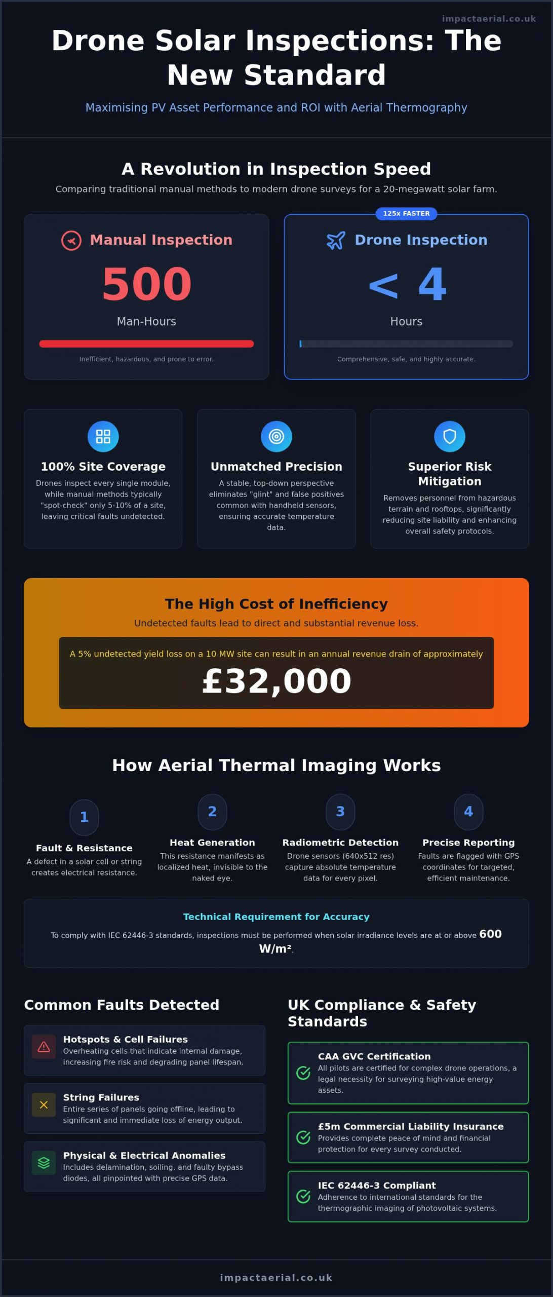
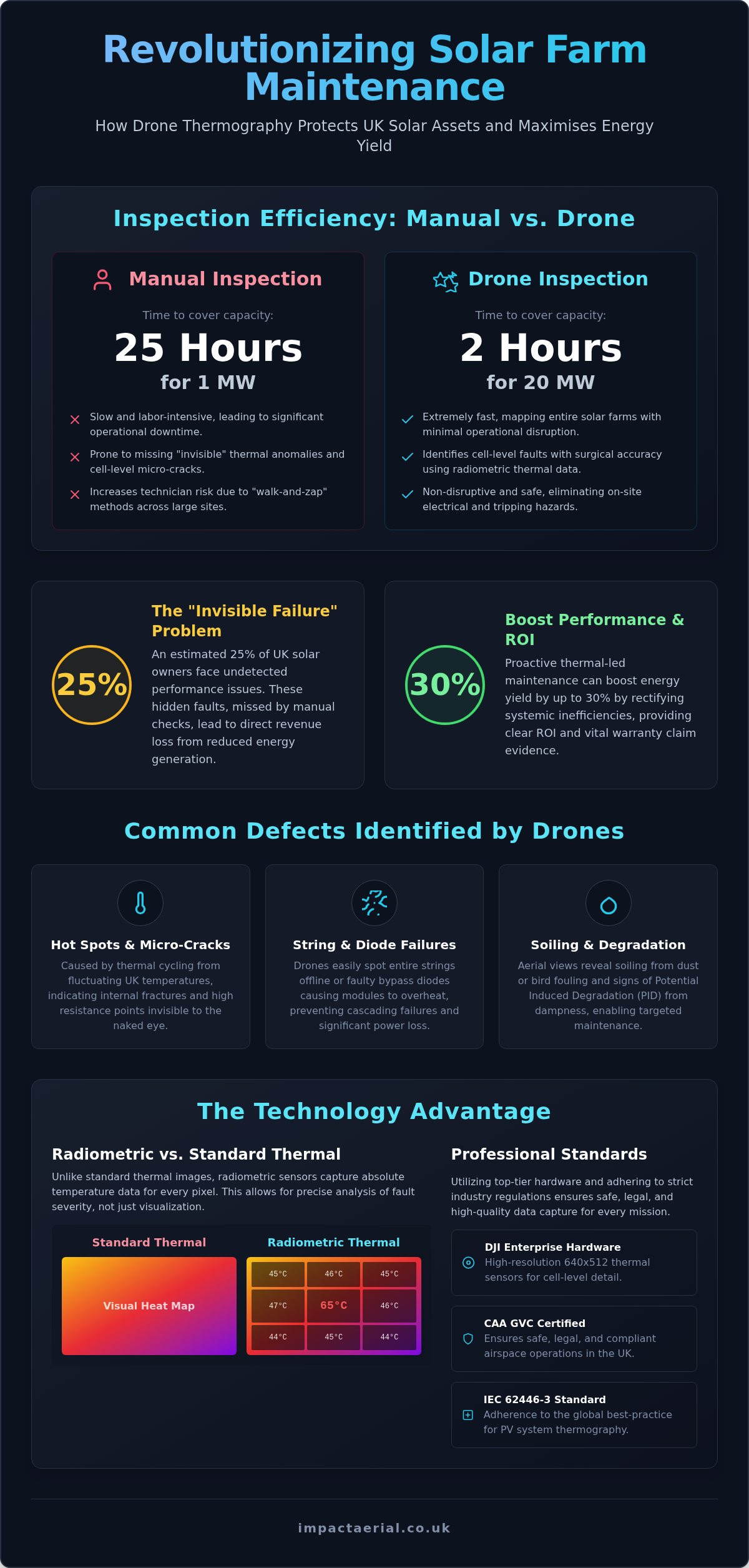
A single technician performing a manual inspection can take up to 25 hours to cover just one megawatt of solar capacity, yet a professional drone can survey 20 megawatts in as little as two hours. For UK solar farm operators, this isn’t just about speed; it’s about the financial risk of undetected string failures and the high cost of traditional “walk-and-zap” methods. You understand that maintaining peak efficiency is essential, but manual checks often leave your investment vulnerable to hidden defects and insurance non-compliance.

Choosing a professional solar panel drone inspection uk service provides the technical precision needed to protect your assets and maximise energy yield. By leveraging DJI Enterprise hardware and CAA GVC certified expertise, you can identify cell-level faults that are invisible to the naked eye. This guide details how drone thermography identifies defects with surgical accuracy, protects your revenue, and ensures a safe, non-disruptive inspection process. We’ll examine the 2026 regulatory requirements, the importance of the IEC 62446-3 standard, and how high-resolution data translates into a clear, actionable report for your maintenance team.

Key Takeaways

  • Learn how radiometric thermal sensors pinpoint “invisible failures” and electrical resistance that manual checks often miss.
  • Discover why a professional solar panel drone inspection uk can map a 5MW farm in hours, significantly reducing technician risk and operational downtime.
  • Understand the essential pre-flight documentation and CAA airspace compliance needed to ensure a safe, legal, and non-disruptive aerial survey.
  • See how high-resolution data capture and post-production reporting provide the precise evidence required for manufacturer warranty claims and insurance audits.
  • Explore how central UK deployment and specialist DJI Enterprise hardware guarantee rapid, high-tier technical surveying for national solar assets.

Why Solar Panel Drone Inspections are Essential for UK Asset Managers

Asset management in the UK solar sector has moved beyond simple visual checks. A professional solar panel drone inspection uk utilizes Unmanned Aerial Vehicles (UAVs) equipped with high-resolution radiometric thermal sensors to map the health of photovoltaic (PV) assets. Unlike standard photography, these sensors capture temperature data for every single pixel. This allows technicians to see electrical resistance and thermal anomalies that are invisible to the naked eye. This transition to data-centric monitoring is no longer optional; it’s a financial necessity for protecting large-scale investments.

The “Invisible Failure” problem is a significant threat to UK solar farms. It’s estimated that 25% of UK solar owners currently face undetected performance issues that skip past traditional manual inspections. When a string fails or a bypass diode malfunctions, the loss in kilowatt-hours translates directly to lost revenue. Relying on “walk-and-zap” methods is often too slow and misses the subtle heat signatures that indicate a failing component. By the time a manual crew finds a fault, months of peak generation may have already been lost.

The UK’s unique climate also plays a critical role in asset degradation. Coastal installations are constantly battered by corrosive salt spray, while rural sites deal with aggressive lichen growth and bird fouling. British dampness can lead to potential induced degradation (PID) and insulation faults that are difficult to pinpoint from the ground. The Science of Aerial Thermography allows asset managers to detect these environmental impacts early, ensuring that small issues don’t escalate into site-wide failures.

Common Defects Found in UK Solar Arrays

  • Hot Spots and Micro-cracks: These are often caused by thermal cycling, where the UK’s fluctuating temperatures cause cells to expand and contract, leading to internal fractures.
  • String and Diode Failures: Drones can identify entire strings that have dropped offline or faulty bypass diodes that are causing modules to overheat.
  • Specific Soiling Patterns: Aerial views reveal how industrial soot or agricultural dust settles across an array, allowing for more targeted cleaning schedules.

The ROI of Proactive Aerial Thermography

Proactive inspections offer a clear path to increased energy output. Early detection doesn’t just prevent total module failure; it significantly reduces fire risks associated with electrical arcing. Having high-resolution thermal data provides the “burden of proof” required to support manufacturer warranty claims before they expire. Booking a regular solar panel drone inspection uk ensures your portfolio remains compliant and profitable. Some industry professionals report that thermal-led maintenance can lead to a performance boost of up to 30% by identifying and rectifying systemic inefficiencies that were previously hidden.

The Science of Aerial Thermography: How Thermal Drones Detect Defects

Thermal drones identify defects by detecting infrared radiation emitted by solar modules. When a cell or component develops high electrical resistance, it generates excess heat. This heat signature is captured by the drone’s sensor, allowing us to visualize faults that aren’t apparent in the visible spectrum. The Science of Aerial Thermography demonstrates that these temperature variations are direct indicators of electrical health. High-tier hardware, such as the DJI Enterprise series, provides the resolution needed to move beyond simply seeing a hot spot. With a 640×512 thermal sensor, we can identify specific faulty cells within a single module from a safe flight altitude, providing the granular detail necessary for precise maintenance.

Radiometric Data vs. Standard Thermal Imaging

Standard thermal imaging produces a visual map of heat, but it lacks the underlying data required for technical analysis. Radiometric thermography is the gold standard for PV inspections because it captures absolute temperature values for every single pixel in the image. This data allows asset managers to quantify the severity of a defect. If a cell is 20°C hotter than its neighbors, it indicates a far more critical failure than a 5°C variance. Our PV solar farm thermal surveys provide this level of quantitative detail, ensuring your maintenance reports are based on hard data rather than visual estimation.

Environmental Conditions for a Successful UK Survey

Precision in a solar panel drone inspection uk depends heavily on environmental variables. To achieve valid thermal contrast, the IEC 62446-3 standard requires a minimum irradiance of 600 W/m². We typically aim for “solar noon” to ensure the sun is at its highest point, minimizing shadows and maximizing thermal signatures.

  • Irradiance Levels: High solar radiation is essential to create the thermal “stress” required to reveal defects.
  • Wind Speeds: We monitor wind carefully, as high speeds can cause convective cooling that masks heat signatures.
  • Cloud Cover: Consistent sky conditions are vital. Intermittent clouds cause fluctuating irradiance, which can lead to false positives.
  • Emissivity and Angles: We adjust for how different glass materials reflect heat to ensure the sensor captures true temperature values.

Managing the British weather window is a meticulous process. We don’t just fly when it’s sunny; we fly when the atmospheric conditions meet the strict technical criteria for data integrity. This ensures that every report we deliver is both accurate and legally compliant for insurance or warranty purposes.

Solar Panel Drone Inspection UK: The Complete Guide for 2026

Drone Surveys vs. Manual Inspections: A Cost and Safety Comparison

Traditional manual inspections are increasingly viewed as a legacy approach that introduces unnecessary risk and expense. When you commission a solar panel drone inspection uk, you’re replacing a slow, subjective process with a high-speed, data-driven methodology. Research indicates that a manual technician can take up to 25 hours to inspect a single megawatt of capacity. In contrast, a professional drone crew can cover 20 megawatts in just two to four hours. This isn’t just a marginal gain; it’s a fundamental shift in how UK asset managers maintain portfolio health.

Speed and Efficiency on Large-Scale PV Farms

Automated flight paths ensure that every asset is captured with 100% coverage, leaving no gaps in the data. Unlike manual crews who may miss modules due to fatigue or difficult terrain, a drone follows a precise GPS-guided grid. This efficiency allows for inspections that don’t require system shutdowns, ensuring your farm continues to generate revenue while the survey is underway. For a 10-hectare site, the timeline moves from several days of ground-based labor to a single afternoon of aerial data collection. This rapid turnaround is essential for catching faults during the specific “weather windows” required for valid thermal contrast.

Safety Standards and Insurance Compliance

Safety is the most compelling reason to transition away from manual “walk-and-zap” inspections. For commercial rooftop solar, drones completely eliminate “working at height” risks. There’s no longer a need for technicians to navigate fragile roof structures or carry heavy equipment across steep pitches. Utilizing a professional drone survey also provides a robust digital trail for commercial insurance audits. Our CAA GVC certified pilots operate under strict safety protocols, backed by £5m commercial liability insurance, which offers the level of reassurance that major UK insurers now demand.

Handheld thermography is often hindered by the “human error” factor. A technician on the ground may struggle to maintain the correct viewing angle or distance, leading to inconsistent data. Drones maintain a consistent altitude and angle of incidence, producing objective, repeatable results. This consistency is vital when comparing year-on-year degradation. By choosing a solar panel drone inspection uk, you’re investing in a safer, more reliable, and significantly more cost-effective asset health check that satisfies both internal safety boards and external stakeholders.

Planning Your Solar Inspection: Best Practices for UK Site Managers

Successful execution of a solar panel drone inspection uk begins long before the aircraft arrives on site. For asset managers, the preparation phase is critical to ensure data integrity and operational safety. A professional drone team requires a comprehensive pre-flight information pack, including high-resolution site maps, total MWp capacity, and precise inverter locations. This allows the pilot to program autonomous flight paths that guarantee 100% asset coverage. In the UK’s complex airspace, we also conduct thorough checks for NOTAMs (Notice to Airmen) and Flight Restriction Zones (FRZs), particularly for assets located near airports or military installations.

Industry standards for 2026 have solidified around the annual “health check” model. Conducting a full thermal survey once a year ensures that your asset remains compliant with insurance requirements and manufacturer warranty terms. This regular cadence allows for trend analysis, where year-on-year degradation can be measured with scientific precision. If you’re managing a portfolio across England or Wales, our Birmingham hub provides a central base for rapid deployment to ensure these annual windows aren’t missed due to the unpredictable British weather.

Understanding the Deliverables and Data Integration

The output of a modern survey is far more than just a collection of images. We provide a hierarchy of deliverables designed for different stakeholders. This includes high-resolution orthomosaic maps, which act as a “digital twin” of the entire array. Every detected anomaly is tagged and categorized by severity, from minor cell-level hotspots to critical string failures. By utilizing a high-specification survey drone, we produce data that integrates seamlessly into your existing GIS platforms or asset management software, allowing your maintenance teams to navigate directly to faulty modules using GPS coordinates.

Regulatory Compliance in the UK

Compliance is the cornerstone of professional aerial surveying. It’s a legal requirement that any pilot conducting commercial work in the UK holds a valid drone license, specifically the CAA GVC (General Visual Line of Sight Certificate). Beyond flight permissions, site managers must ensure that the drone operator provides site-specific Risk Assessments and Method Statements (RAMS) that account for the unique hazards of an industrial environment. We also prioritize GDPR and privacy compliance, ensuring that data capture is strictly limited to the site boundaries, which is especially vital for rooftop solar in residential or public-facing areas.

Ensuring your site meets these rigorous standards protects your business from liability and ensures the resulting data is legally defensible. If you’re ready to schedule your annual health check, contact us for a professional PV solar farm thermal survey tailored to your specific site requirements.

Maximising PV ROI with Impact Aerial’s Specialist Drone Surveys

Securing a high return on investment for solar assets requires more than just identifying faults; it requires a partner who understands the operational nuances of the UK energy sector. At Impact Aerial, we bridge the gap between technical data collection and actionable maintenance reporting. While our sensors capture cinematic-grade detail, our primary focus remains the technical accuracy required for a solar panel drone inspection uk. Our Birmingham headquarters serves as a strategic central hub, allowing our teams to deploy rapidly to solar assets across England and Wales as soon as an optimal weather window opens.

Safety and compliance aren’t just checkboxes for our operation; they’re the foundation of our service. Operating with £5m commercial liability insurance and full CAA GVC certification provides the reassurance and tangible legal protection that asset managers require. We understand that large-scale PV farms are high-value industrial environments where a “zero-incident” approach is non-negotiable. This meticulousness extends to our post-production phase, where raw thermal data is transformed into prioritized maintenance reports.

Expertise You Can Trust

We utilize DJI Enterprise hardware specifically for its mission-critical reliability and high-resolution thermal capabilities. This technology, combined with our extensive experience across the construction and property sectors, allows us to navigate complex industrial sites with precision. Our professional drone services are designed to move from data collection to decision-making as efficiently as possible. We don’t just deliver a folder of images; we deliver a prioritized list of defects that empowers O&M teams to act immediately, restoring lost yield and protecting long-term revenue.

  • Strategic Deployment: Rapid response from our Birmingham base to sites across the UK.
  • Technical Precision: Utilizing radiometric sensors for cell-level fault identification.
  • Full Compliance: CAA GVC certified pilots and £5m commercial liability insurance.
  • Actionable Reporting: Data formatted for immediate integration into asset management platforms.

Request Your 2026 Solar Health Audit

Every solar portfolio has unique technical requirements, whether you’re managing a single commercial rooftop or a multi-site ground-mount array. Our consultation process begins by matching our sensor payloads to your specific data needs, ensuring the resulting report meets the exact standards of your insurance provider or manufacturer warranty terms. By choosing a specialist solar panel drone inspection uk, you’re investing in the long-term health and efficiency of your renewable energy assets.

Don’t let undetected string failures or micro-cracks erode your generation revenue. Secure your asset’s future by partnering with a technologically adept surveying team. Contact us today to receive a tailored quote for your solar health audit and discover how professional drone thermography can transform your maintenance strategy.

Securing Peak Performance for Your Solar Portfolio

As the UK solar market matures, the transition to aerial thermography has become a fundamental requirement for efficient asset management. A professional solar panel drone inspection uk offers the speed and technical depth necessary to pinpoint cell-level defects that manual teams simply cannot detect. This data-centric approach doesn’t just improve safety; it directly protects your bottom line by identifying revenue-draining failures before they escalate into critical system shutdowns.

Impact Aerial brings together CAA GVC Certified Pilots and specialist DJI Enterprise thermal hardware to ensure every survey meets the highest industry standards. Backed by £5m commercial liability insurance, we offer the reassurance that your high-value assets are in expert hands. We’re ready to help you move from reactive maintenance to a proactive, data-driven strategy that guarantees peak performance across your entire portfolio.

Book your professional UK solar panel drone inspection with Impact Aerial today and secure the future of your energy investment.

Frequently Asked Questions

How often should solar panels be inspected by a drone in the UK?

Annual health checks are the recommended industry standard for 2026. Regular 12-month intervals allow asset managers to track degradation trends and provide the necessary documentation for manufacturer warranty claims. This cadence ensures that minor cell defects don’t escalate into site-wide string failures, maintaining consistent energy output throughout the lifecycle of the array.

Can a drone detect a single faulty cell in a large solar farm?

Yes, high-resolution radiometric sensors can identify a single faulty cell within a large-scale array. By utilizing hardware with a minimum thermal resolution of 640×512 pixels, pilots can pinpoint individual hotspots and micro-cracks from a safe flight altitude. This granular level of detail is essential for precise maintenance, allowing O&M teams to navigate directly to the specific module requiring repair.

What weather conditions are required for a thermal solar survey?

Valid thermal data requires a minimum irradiance of 600 W/m² to create sufficient thermal contrast. Surveys should be conducted during “solar noon” with clear skies or consistent cloud cover to avoid false positives caused by fluctuating light. Wind speeds must remain low to prevent convective cooling from masking heat signatures, while rain or high humidity will invalidate the radiometric readings.

Is a drone solar inspection cheaper than a manual inspection?

Drone inspections are significantly more cost-effective than manual methods, primarily due to the massive reduction in labor hours. While a manual crew might take 25 hours to inspect a single megawatt, a drone can cover 20 megawatts in under four hours. This speed reduces site downtime and eliminates the expensive safety equipment and insurance premiums associated with technicians working at height.

Do I need to shut down my solar farm during the drone flight?

No, the solar farm must remain fully operational during the flight. For a solar panel drone inspection uk to be effective, the panels need to be under electrical load to generate the heat signatures that indicate resistance or failure. Shutting down the system would cool the components, making it impossible for the thermal sensors to detect anomalies or faulty cells within the strings.

What qualifications should a drone pilot have for solar inspections?

For commercial solar surveys in the UK, the pilot must hold a General Visual Line of Sight Certificate (GVC) issued by the Civil Aviation Authority. This qualification demonstrates the pilot’s competency in managing complex flights in the “Specific Category.” Additionally, operators should carry specialist commercial drone insurance, with a minimum of £5m public liability coverage being the standard for industrial site access.

How long does it take to receive the final thermal inspection report?

The turnaround time for a final thermal inspection report typically ranges from three to five working days, depending on the site’s total capacity. This period allows for the rigorous post-production phase, where raw radiometric data is processed into high-resolution orthomosaic maps and annotated PDF reports. Large-scale portfolios may require additional time for AI-assisted anomaly tagging and severity categorization.

Can drones inspect both rooftop and ground-mounted solar panels?

Drones are highly versatile and can inspect both large-scale ground-mounted solar farms and complex commercial rooftop arrays. Aerial surveys are particularly beneficial for rooftops as they eliminate the need for scaffolding or fragile roof access, reducing safety risks for personnel. Whether the asset is a sprawling rural site or an industrial warehouse roof, the solar panel drone inspection uk process provides total coverage without the logistical challenges of ground-based surveying.

Drone Survey Birmingham: The Complete Guide to Aerial Inspections in 2026

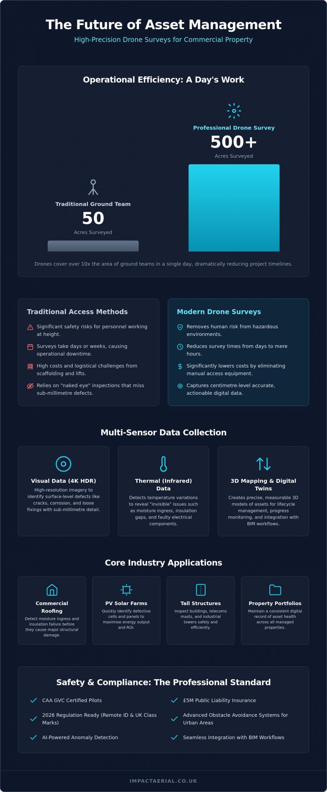
Did you know that a professional drone survey can cover up to 500 acres in a single day, while traditional ground teams often struggle to reach 50? In a dense urban environment, the logistical nightmare of erecting scaffolding often feels like an unavoidable tax on property maintenance. If you’re managing commercial assets, a drone survey birmingham offers a way to bypass these escalating costs and the inherent safety risks of manual inspections at height.

We understand that reliability and meticulous compliance are your top priorities when commissioning aerial work. This guide explains how to secure high-resolution 4K and thermal data for your decision-making while significantly reducing operational downtime. We’ll also break down the critical 2026 CAA regulatory updates, from Remote ID mandates to the new UK class marks, and explain how our advanced drone technology delivers the centimetre-level accuracy your Birmingham project demands.

Key Takeaways

  • Learn how high-precision UAV sensors transform asset management by providing actionable digital data for structural integrity and external cladding inspections.
  • Compare the operational efficiency of drones versus traditional access methods, focusing on how to remove human risk while reducing survey times from days to hours.
  • Explore the specific benefits of thermal and 3D mapping for detecting moisture ingress in commercial roofing and maximising ROI on PV solar farm arrays.
  • Understand the 2026 regulatory landscape to ensure your drone survey birmingham is conducted by CAA GVC certified pilots with professional £5m liability insurance.

What is a Drone Survey and How is it Transforming Birmingham’s Asset Management?

A professional drone survey birmingham represents a significant technical evolution in how we monitor the built environment. Rather than relying on static images, modern Unmanned Aerial Vehicles (UAVs) act as airborne data collection platforms. They use 4K HDR sensors and thermal imaging to capture high-precision datasets that were previously inaccessible. This shift from simple visual observation to actionable digital data is critical in 2026. For property managers in the West Midlands, this means moving away from traditional “naked eye” inspections that often miss sub-millimetre defects or hidden thermal leaks.

To understand the broader context, it’s helpful to look at What is an Aerial Survey and how it has historically served as a foundation for mapping and structural analysis. Today, this technology facilitates proactive asset lifecycle management. By identifying issues before they require emergency repairs, Birmingham’s commercial property owners can maintain structural integrity while controlling long-term costs. It’s no longer just about taking a photo; it’s about creating a digital record of an asset’s health.

To better understand the practical application of this technology in the local area, watch this video regarding professional drone services:

The Core Technology: More Than Just a Flying Camera

Precision is the hallmark of professional operations. We utilize DJI Enterprise hardware because it offers the stability and signal reliability required for complex urban environments like Birmingham city centre. These platforms carry 4K HDR cameras capable of capturing sub-millimetre detail on structural defects, from hairline cracks in masonry to loose cladding fixings. The process doesn’t end when the drone lands. Raw data is meticulously processed into a comprehensive survey drone inspection report. These reports provide stakeholders with a clear, data-backed roadmap for maintenance, prioritising urgent repairs to prevent further degradation.

Why 2026 is the Year of the Autonomous Inspection

The landscape of aerial data collection has changed rapidly. In 2026, advanced obstacle avoidance systems allow for safe flight in congested city centres where traditional methods would be too risky or disruptive. AI now plays a vital role, automatically scanning thousands of images to identify rust, cracks, and thermal anomalies with a level of consistency humans can’t match. This data isn’t just for standalone reports; it integrates directly into Building Information Modelling (BIM) workflows. This allows architects and engineers to overlay current aerial data onto digital twins of Birmingham’s most iconic commercial assets. As the demand for a drone survey birmingham grows, the focus remains on delivering high-fidelity data that supports smarter, faster business decisions.

Types of Aerial Data: Visual, Thermal, and 3D Mapping Explained

Selecting the correct data capture method is the most critical decision in any drone survey birmingham. A standard visual inspection is excellent for identifying surface cracks, but it won’t reveal the hidden moisture trapped beneath a warehouse roof. To provide a truly comprehensive asset report, we deploy a range of specialised sensors tailored to the specific structural or environmental challenge. This technical approach ensures that the data we provide is not just a collection of images, but a functional tool for asset management.

High-resolution visual data remains the primary tool for structural integrity assessments on tall buildings and telecommunications masts. Using 4K HDR cameras, we identify corrosion, loose fixings, or masonry decay that ground-based teams simply cannot see. When we need to understand the “invisible” health of a building, we switch to thermal (infrared) sensors. These detect minute temperature variances, highlighting moisture ingress or insulation gaps in commercial roofing systems before they become costly structural failures. Adhering to UK drone safety and compliance laws ensures these complex data sets are collected legally and safely in urban environments.

For construction and land development, photogrammetry and 3D mapping allow us to create accurate digital twins of Birmingham’s evolving skyline. While photogrammetry is perfect for visual site monitoring, LiDAR (Light Detection and Ranging) is the superior choice for topographic surveys on complex terrain. LiDAR uses laser pulses to penetrate vegetation and provide centimetre-level accuracy, even on overgrown sites. This distinction is vital for developers who need precise ground-level data without the time-consuming process of manual clearing.

Thermal Imaging for Energy Efficiency

Thermal drones are essential for maintaining PV solar farms. By identifying “hot spots” in real-time, we help operators prevent cell failure and maximise energy output. This technology is equally valuable for industrial warehouses across the West Midlands, where detecting insulation gaps is a key step in meeting UK Net Zero building standards. If you need to evaluate your property’s thermal performance, you can book a professional property survey to get started.

Visual Surveys for Preventative Maintenance

Preventative maintenance is about catching small issues before they escalate. We conduct close-quarter inspections of chimney stacks, bridges, and listed Birmingham heritage sites without the need for expensive scaffolding or cherry pickers. A drone survey birmingham provides the high-detail imagery required for insurance claims and long-term structural preservation. To ensure your assets are protected by the most suitable policy, you can check out Compare Property Insurance to find the best rates for your portfolio. This approach allows for continuous construction site monitoring without interrupting ground operations, keeping your project on schedule and within budget.

Drone Survey Birmingham: The Complete Guide to Aerial Inspections in 2026

Drones vs. Traditional Access: A Commercial Comparison for 2026

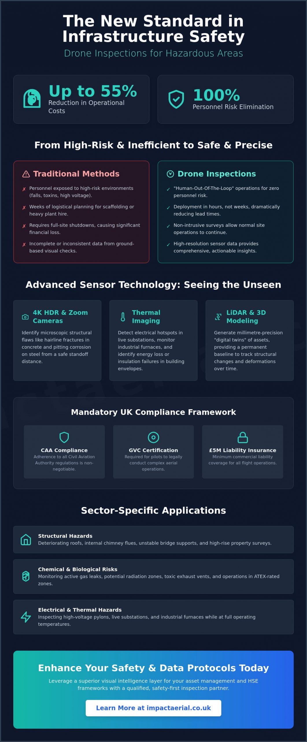
For decades, commercial property managers in the West Midlands accepted the logistical burden of scaffolding as a necessary evil. In 2026, a drone survey birmingham has replaced these cumbersome methods by offering a faster, safer, and more data-rich alternative. Traditional access methods, such as rope access or cherry pickers, require extensive setup times and introduce significant health and safety liabilities. By removing the human element from high-risk environments, we eliminate the primary cause of workplace accidents at height while providing a more detailed perspective of the asset.

The difference in speed is stark. A manual inspection of a complex multi-storey structure that typically requires three days of scaffolding erection and surveying can now be completed in a four-hour drone flight. This efficiency doesn’t come at the cost of precision. We use pre-programmed, repeatable flight paths to ensure that asset comparisons are consistent year-on-year. This creates a reliable audit trail for structural health, allowing you to track the degradation of specific components with centimetre-level accuracy over several years.

Reducing Operational Downtime in Birmingham

Conducting a drone survey birmingham allows your commercial assets to remain fully operational throughout the inspection. In busy commercial hubs like Brindleyplace, traditional scaffolding causes significant disruption to tenants and pedestrians, often requiring pavement closures and complex permits. Drone operations minimise this footprint entirely. We also provide rapid deployment services, responding to emergency structural concerns or storm damage within hours. This agility ensures that critical safety decisions are made based on real-time data rather than waiting for a manual team to arrive on-site.

The ROI of Aerial Data Collection

The return on investment is clear when evaluating the commercial benefits of modern technology. By choosing a professional drone survey over traditional scaffolding hire, businesses avoid the high costs of equipment rental and the labour-intensive assembly process. Early detection of rust, loose cladding, or minor leaks prevents these issues from developing into catastrophic failures that require six-figure repair budgets. Most property managers achieve a 70% reduction in total inspection costs by replacing traditional access methods with high-precision aerial data collection. This financial saving, combined with superior data, makes the transition to drone-led inspections a strategic business decision for any asset owner.

Core Industry Applications: From Solar Farms to Property Portfolios

A drone survey birmingham provides the high-precision data necessary for diverse commercial sectors, ranging from heritage preservation to heavy industrial site management. While visual inspections are now a baseline requirement, the true value lies in the sector-specific application of sensor technology across the West Midlands. For Birmingham landlords, rapid external cladding and roof surveys are vital for maintaining compliance with fire safety and building regulations. These surveys provide a meticulous record of an asset’s condition without the logistical delays or high costs associated with traditional access methods.

In the infrastructure sector, high-zoom enterprise drones allow for the safe inspection of rail networks and bridges. Engineers can identify fatigue, corrosion, or structural decay from a distance, completely removing personnel from track-side hazards. This methodology is becoming the standard for asset managers who prioritise safety and data accuracy. For the West Midlands’ extensive bridge networks, this approach avoids the need for complex road closures, significantly reducing the cost of routine maintenance while ensuring every bolt and weld is documented for historical comparison.

Specialised PV Solar Farm Thermal Surveys

PV solar farm thermal surveys are essential for maintaining peak efficiency on large-scale arrays. Using radiometric thermal sensors, we detect faulty bypass diodes and string failures that are invisible to the naked eye. This georeferenced data allows maintenance teams to navigate directly to the affected panel, reducing labour time and ensuring the site meets 2026 UK renewable energy performance standards. By identifying cell degradation early, operators can maximise their return on investment and prevent small faults from escalating into significant power losses. Our approach provides a level of technical detail that ground-based teams simply cannot match within the same timeframe.

Drones in the Construction Lifecycle

The construction sector relies on drones for more than just progress photos. During the earthworks phase, drones equipped with RTK technology generate centimetre-accurate point clouds. This allows for precise volume calculations of stockpiles and excavations, ensuring that contractors are billed accurately for material moved. Weekly progress captures provide stakeholders with a clear, visual record of development, which is essential for transparent reporting and project management. Read our guide to professional drone services to see how drones improve site safety throughout the build.

If your business requires high-precision data for asset management or site monitoring, you can book a professional drone survey to secure an accurate, compliant assessment of your commercial property.

Safety, Compliance, and Hiring: Choosing a Professional UK Drone Service

Commissioning a drone survey birmingham requires more than just finding a skilled pilot; it demands a partner who operates within the strict legal framework established for 2026. As the technology has matured, so have the regulations. Modern aerial inspections are no longer viewed as experimental but as a regulated professional service. Hiring an uncertified operator doesn’t just risk poor data quality; it exposes your business to significant legal and financial liabilities. We prioritize meticulous compliance to ensure every flight is conducted safely and according to the latest national standards.

Risk mitigation is the cornerstone of urban operations. Before any drone takes flight in a congested area like Birmingham city centre, a comprehensive pre-flight site assessment is mandatory. This includes identifying local hazards, establishing emergency procedure protocols, and ensuring Remote ID is active as per 2026 mandates. Data privacy is equally critical. Professional operators must adhere to strict GDPR protocols when handling aerial imagery that may capture public spaces or private property, ensuring that your data collection remains compliant with UK privacy laws.

Insurance is another non-negotiable factor. While some hobbyist-level operators may offer basic cover, £5m commercial liability insurance is the industry standard for enterprise work. This level of protection provides the reassurance that all stakeholders are covered in the unlikely event of an incident. It reflects a commitment to professional standards that matches the high-precision data we deliver for your commercial assets.

Understanding CAA Regulations in 2026

The distinction between hobbyist flying and commercial ‘Specific Category’ operations is sharper than ever. The CAA GVC (General Visual Line of Sight Certificate) is the legal necessity for pilots conducting complex commercial work in 2026. This certification proves the pilot has the technical knowledge and flight competence to operate in challenging environments. If you hire an uncertified or uninsured operator, your business could be held liable for any regulatory breaches. Consult our UK drone license guide for full compliance details and to understand the current requirements for Flyer and Operator IDs.

What to Look for in a Birmingham Drone Partner

When selecting a partner for a drone survey birmingham, look for proven experience in your specific industry. A team that understands thermal solar arrays or construction monitoring will provide far more value than a generalist. The quality of deliverables is the ultimate metric of success. You should receive actionable, data-rich reports and 3D models, not just raw footage that requires further processing. Local expertise is also a significant advantage. A Birmingham-based team understands the local airspace constraints and can offer rapid West Midlands deployment for emergency inspections. Contact Impact Aerial for a professional consultation on your next Birmingham survey project to ensure your data is captured with precision and total compliance.

Future-Proofing Your Assets with Precision Aerial Data

Adopting a drone survey birmingham is no longer just a trend for forward-thinking property managers; it’s a fundamental risk mitigation strategy for 2026. By transitioning from manual, high-risk inspections to data-driven aerial surveys, you secure a more accurate record of structural health while significantly reducing operational costs. Whether you’re managing a vast PV solar farm or a heritage property in the city centre, the ability to detect defects early prevents minor maintenance issues from escalating into expensive structural failures.

Choosing a partner who prioritises meticulous compliance is essential for protecting your commercial interests. As a local specialist, we provide the technical expertise required to navigate the 2026 regulatory landscape safely and legally. Our team utilizes a Birmingham-based specialist fleet operated by CAA GVC certified pilots, backed by £5m commercial liability insurance for your total peace of mind. High-precision data is the key to smarter, more efficient asset lifecycle management.

Request a Professional Drone Survey Quote from Impact Aerial today and discover how we can streamline your next inspection project. We’re ready to help you elevate your asset management standards with industry-leading aerial intelligence.

Frequently Asked Questions

Are drone inspections as accurate as manual inspections?

Drone inspections frequently exceed the accuracy of traditional manual methods. By using DJI Enterprise hardware equipped with 4K HDR sensors, we capture sub-millimetre detail on structural defects that might be missed by the naked eye. When combined with RTK technology, these systems provide centimetre-level positioning data, which is essential for high-precision 3D mapping and repeatable year-on-year asset comparisons.

What are the legal requirements for drone inspections in the UK for 2026?

In 2026, the Civil Aviation Authority (CAA) requires all commercial pilots to hold a GVC (General Visual Line of Sight Certificate) for complex operations. All drones must have Remote ID enabled to broadcast their identity and location during flight. Additionally, operators must display a valid Operator ID, and drones placed on the market must carry a specific UK class mark, ranging from UK0 to UK6.

How much does a drone roof survey cost in Birmingham compared to scaffolding?

While we don’t provide fixed costs without a site assessment, industry data indicates that drone surveys are significantly more cost-effective than traditional access. You eliminate the high daily hire rates and the labour costs associated with scaffolding assembly and strike. For large-scale commercial assets, a drone survey birmingham can reduce total inspection expenditure by 50% to 75% compared to manual methods.

Can drones perform inspections in confined spaces or indoors?

Specialised UAVs are designed specifically for internal and confined space inspections. These units feature protective cages and sophisticated collision-avoidance sensors, allowing them to navigate industrial tanks or large Birmingham warehouses safely. This capability removes the requirement for personnel to enter hazardous, high-risk, or oxygen-depleted environments, significantly improving site safety protocols.

What happens if the weather is bad on the day of the drone survey?

High winds and heavy rain are the primary reasons for rescheduling a flight. While our enterprise hardware can handle moderate conditions, safety and data clarity remain our priorities. We monitor local weather forecasts meticulously in the days leading up to a project and coordinate with clients to find the next available window with optimal flying conditions.

Do I need to notify my neighbours or Birmingham City Council before a drone flight?

Professional operators handle all necessary pre-flight planning and risk assessments. For most private commercial sites, you don’t require formal council permission, though we check for local airspace restrictions near airports or sensitive sites. We always recommend informing immediate neighbours as a matter of professional courtesy to maintain transparency and address any privacy concerns early.

How long does it take to receive the inspection report after the flight?

Most comprehensive inspection reports are delivered within 48 to 72 hours of the flight completion. This timeframe allows our technical team to process raw 4K imagery or thermal data into actionable, professional reports. This rapid turnaround is a major advantage for a drone survey birmingham, as it enables property managers to make faster, data-backed decisions on urgent structural repairs.

Can drones detect thermal leaks or moisture in a building’s structure?

Radiometric thermal sensors are highly effective at detecting moisture ingress and heat loss that is invisible to the naked eye. By identifying minute temperature variances on a building’s surface, drones highlight exactly where insulation has failed or where water is trapped beneath a roof membrane. This data is vital for Birmingham businesses aiming to meet UK Net Zero building standards and reduce energy costs.

Drone Thermal Survey for Solar Farms: The Ultimate Guide to PV Asset Optimisation

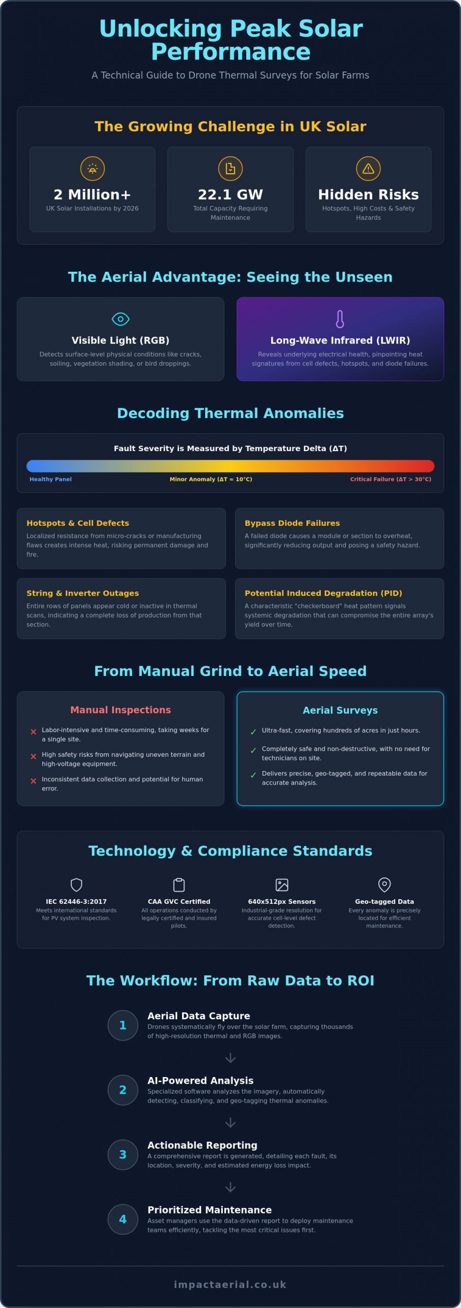
With the UK surpassing 2 million solar installations in early 2026, the challenge of maintaining peak efficiency across 22.1 GW of capacity has reached a critical tipping point. You likely recognize the frustration of watching energy yields decline due to unidentified hotspots, while the high cost and safety risks of manual IV curve testing make traditional inspections feel like a liability. Relying on inconsistent reporting from previous providers only adds to the uncertainty of your asset’s long-term health. A professional drone thermal survey for solar farms changes this dynamic by converting raw aerial data into a prioritized maintenance roadmap.

This guide explores how advanced thermography identifies critical faults with precision, ensuring you meet the internationally recognized IEC 62446-3:2017 standards for safety and performance. You’ll discover how to leverage AI-powered analysis to increase energy output and extend the longevity of your PV assets. We will cover everything from the latest 2026 CAA regulatory requirements to the specific hardware and software that turn complex thermal imagery into actionable ROI. By the end of this article, you’ll understand how to transition from reactive repairs to a meticulous, data-driven strategy that guarantees your solar farm remains a high-performing, compliant asset.

Key Takeaways

  • Distinguish between visible light and long-wave infrared data to pinpoint thermal anomalies that are invisible to the naked eye.
  • Identify specific cell-level defects, such as hotspots and bypass diode failures, alongside broader string and inverter outages.
  • Understand why commissioning a professional drone thermal survey for solar farms requires CAA GVC certified pilots and industry-standard liability insurance.
  • Learn how to translate raw aerial mapping data into actionable maintenance reports that prioritize repairs based on energy loss impact.
  • Discover the precise workflow and specialist hardware needed to maximize the long-term ROI and operational safety of your PV assets.

What is a Drone Thermal Survey for Solar Farms?

A drone thermal survey for solar farms is a specialized diagnostic process that uses aerial platforms to capture high-resolution temperature data across photovoltaic installations. By integrating thermal sensors with advanced flight systems, operators can visualize heat signatures that remain invisible to the naked eye. This process relies on What is Thermography? to convert infrared radiation into a visual map of an asset’s thermal profile. Unlike standard photography, which uses visible light (RGB) to document physical surface conditions like cracks or bird droppings, long-wave infrared (LWIR) data capture identifies the underlying electrical health of individual cells and components.

For industrial compliance in 2026, professional surveys now mandate sensors with a minimum resolution of 640×512 pixels. This level of detail is necessary to distinguish between minor surface debris and genuine internal cell defects from a safe flight altitude. The drone acts as a stabilized, GPS-locked platform, ensuring that sensors are deployed at precise angles to maintain data consistency across thousands of panels. This meticulous approach ensures that every anomaly is geo-tagged for exact location identification during subsequent maintenance.

To better understand how these advanced systems operate in a real-world environment, watch this demonstration of high-speed aerial inspection:

The Shift from Manual to Aerial Inspections

Manual inspections, including handheld thermography and IV curve tracing, are increasingly seen as obsolete for utility-scale sites. These traditional methods are labor-intensive and often take weeks to complete for a single farm. In contrast, aerial surveys can cover hundreds of acres in a matter of hours. Beyond speed, the safety benefits are undeniable. Technicians no longer need to navigate uneven terrain or work in close proximity to high-voltage equipment, significantly reducing the risk of on-site accidents during routine maintenance audits.

How Thermal Sensors Detect Solar Inefficiency

The core physics of a thermal survey involve identifying where electrical energy is being converted into heat rather than current. When a solar cell or internal bypass diode fails, it creates resistance. This resistance generates a heat signature known as a hotspot. By measuring the “Delta T,” or the temperature difference between a fault and the surrounding healthy panels, specialists can categorize the severity of the issue. A drone thermal survey for solar farms serves as a non-destructive testing (NDT) method for verifying asset health without interrupting energy production.

Identifying Critical Faults: What Aerial Thermography Reveals

Thermal anomalies within a solar array are categorized by their temperature delta (Delta T) compared to the surrounding panel baseline. A temperature difference of 10°C might indicate a minor efficiency drop, while a Delta T exceeding 30°C often signals a critical failure requiring immediate intervention. This classification is vital for prioritizing maintenance. Without understanding the severity of these temperature variances, asset managers risk wasting resources on non-critical issues while ignoring potential fire hazards. A meticulous drone thermal survey for solar farms provides the granular data needed to make these distinctions with technical certainty.

Faults at the cell level, such as micro-cracks or manufacturing flaws, create localized resistance that manifests as heat. According to academic research on UAV thermal imaging, the precision of modern aerial sensors allows for the detection of these anomalies across massive arrays with high repeatability. Systemic issues like Potential Induced Degradation (PID) show up as a characteristic checkerboard pattern of heat across multiple modules, usually located near the negative pole of the string. Identifying these signatures early prevents the gradual degradation of the entire array’s energy yield.

Hotspots and Cell Failures

A single failing cell isn’t just a localized drop in production. It acts as a resistor, dissipating power from healthy cells as heat. If you leave these hotspots unaddressed, they can lead to backsheet browning or catastrophic fire risks. Distinguishing between temporary shading and permanent cell damage is a core part of professional diagnostic reporting. Precise thermal data identifies which modules are nearing the end of their functional life before they compromise the safety of the entire rack.

String Errors and Large-Scale Outages

When an entire string or row goes dark, the financial impact is immediate and significant. Aerial views are the only efficient way to visualize these large-scale patterns across thousands of panels simultaneously. A dead string often points to a blown fuse, a disconnected cable, or a faulty inverter. Detecting these outages early in a financial quarter can save thousands in lost energy production. Owners looking to secure their infrastructure should consider a professional PV solar farm thermal survey to ensure no string goes unmonitored and every fault is documented for rapid repair.

Drone Thermal Survey for Solar Farms: The Ultimate Guide to PV Asset Optimisation

The UK Regulatory Landscape: Safety, Compliance, and Insurance

A professional drone thermal survey for solar farms requires more than high-end sensors; it demands a rigorous adherence to UK aviation law and electrical inspection standards. Operating on industrial sites involves managing risks associated with high-voltage equipment, public footpaths, and sensitive local infrastructure. To ensure data integrity and site safety, surveys must align with BS EN ISO 62446. This international standard governs the documentation and inspection of grid-connected photovoltaic systems, providing a legally defensible framework for warranty claims and safety audits. Meticulous compliance isn’t an optional extra; it’s the foundation of a reliable asset management strategy.

Risk mitigation begins long before the drone takes flight. Every project starts with a detailed pre-flight site assessment (PFSA) to identify local hazards, restricted airspaces, and ground-level obstacles. Emergency procedure protocols are established to manage potential equipment failures or unexpected site intrusions. This structured approach ensures that the survey process remains non-intrusive and safe, allowing the solar farm to continue generating power without interruption while the inspection is underway.

Why CAA GVC Certification is Non-Negotiable

The General Visual Line of Sight Certificate (GVC) is the mandatory qualification for pilots operating drones in the “Specific” category under Civil Aviation Authority (CAA) regulations. This certification proves that the pilot has undergone rigorous theoretical and practical testing to manage complex flight operations. Certified pilots are trained to handle airspace coordination and ground risk management, which is critical when flying near substations or residential boundaries. For a detailed breakdown of the latest requirements, you can read our UK Drone License: A Simple Guide to CAA Rules in 2026. Choosing an uncertified operator doesn’t just risk a fine; it potentially invalidates your site’s operational insurance.

Insurance and Liability for Solar Asset Managers

Hobbyist drone insurance is entirely insufficient for commercial solar environments. Professional surveys require specialist commercial-grade liability insurance that specifically covers aerial work and professional indemnity. While some providers offer lower tiers of coverage, £5m commercial liability insurance is the recognized industry standard for accessing utility-scale solar farms. Impact Aerial maintains a minimum of £5m liability for every project to provide total reassurance to asset managers. This coverage protects the client against third-party claims, accidental equipment damage, and business interruption, ensuring that your investment is fully protected from the moment our team arrives on site.

The Workflow: From Raw Data to Actionable Maintenance Reports

Executing a successful drone thermal survey for solar farms depends on a structured, multi-stage workflow. It isn’t just about flying; it’s about capturing data that is technically valid and legally defensible. The process begins with meticulous planning to align flight schedules with precise meteorological windows. Without the correct environmental variables, the resulting thermal imagery can produce false negatives, leading to missed faults and continued energy loss. This systematic approach ensures that every flight delivers a high-tier data set suitable for long-term asset optimization.

Optimal Conditions for Thermal Accuracy

For a survey to meet international standards like IEC TS 62446-3:2017, solar irradiance must be at least 600W/m². This level of sunlight ensures that the panels are operating at a sufficient capacity to generate detectable heat signatures from internal resistance. In the UK, managing this “window of opportunity” requires constant monitoring of cloud-free intervals. Cloud shadows create thermal noise that obscures genuine defects. Additionally, wind speeds must remain below certain thresholds. High winds cause convective cooling on the panel surface; this can mask subtle hotspots and skew the Delta T measurements required for fault classification.

Data Processing and Post-Production

Once the on-site data capture is complete, the raw thermal video and thousands of individual orthomosaic images move into post-production. This stage uses high-end analytic software to stitch the data into a single, geo-referenced map of the entire site. While AI-powered tools are excellent for the initial detection of anomalies, they aren’t infallible. Meticulous manual verification by a qualified thermographer is essential to filter out false positives caused by reflections or surface debris. This human oversight ensures that the maintenance team only receives accurate, verified data rather than raw, unrefined algorithmic guesses.

This level of technical precision is a hallmark of high-tier operations. You can learn more about how these processes integrate into broader industrial needs in our A Complete Guide to Professional Drone Services in the UK.

The final output is a comprehensive report featuring a “Red, Amber, Green” (RAG) severity rating system. Every identified fault is geotagged with sub-meter accuracy, allowing ground teams to navigate directly to the specific module requiring repair. This prioritized roadmap converts complex aerial data into a clear plan for asset optimization. If you are ready to secure your site’s energy output, book a professional drone thermal survey for solar farms today.

Maximising Solar Farm ROI with Impact Aerial

Maximising the return on investment for a utility-scale solar asset requires a shift from viewing maintenance as a cost to seeing it as a performance driver. A professional drone thermal survey for solar farms provides the empirical evidence needed to eliminate energy leakage. By identifying underperforming strings and faulty modules, asset managers can recover lost generation capacity that would otherwise remain hidden for years. Impact Aerial facilitates this transition by providing high-fidelity data that bridges the gap between aerial observation and electrical rectification. Our Birmingham-based team serves the entire UK renewable sector, ensuring that distance is never a barrier to high-tier technical surveying.

Our commitment to precision is supported by the use of DJI Enterprise drones, which are the industry standard for industrial-grade data capture. These platforms allow us to deploy high-resolution thermal and RGB sensors simultaneously, providing a dual-layered view of asset health. This hardware ensures that every pixel of data is geo-referenced and technically accurate, meeting the stringent requirements of O&M teams who need to execute immediate, targeted repairs. We don’t just provide images; we deliver a bespoke reporting suite tailored to the specific operational needs of your site technicians.

The Financial Case for Annual Thermal Audits

Annual audits are essential for maintaining the long-term viability of a solar portfolio. These surveys allow asset managers to support warranty claims against panel manufacturers by providing undeniable proof of manufacturing defects or premature cell degradation. It’s much easier to secure a replacement module when you have a geo-tagged thermal report showing a clear bypass diode failure. Impact Aerial provides the technical data needed for insurance and warranty validation. By moving to a proactive maintenance model, you can significantly reduce long-term O&M budgets and prevent minor faults from escalating into costly, large-scale outages.

Why Partner with Impact Aerial?

Choosing a survey partner is a matter of trust, compliance, and technical capability. Impact Aerial is defined by a meticulous approach to every project, from the initial pre-flight assessment to the final data delivery. Our credentials provide total reassurance for site owners and managers. We operate with full CAA GVC certification and maintain £5m in commercial liability insurance as standard. This professional foundation, combined with our high-spec hardware and data-centric processes, makes us a trusted specialist for the UK’s leading renewable energy firms.

If you’re looking to secure the longevity and output of your PV assets, the next step is a technical consultation. We can review your solar portfolio and design a survey schedule that aligns with your maintenance windows and regulatory obligations. To discuss your requirements and request a detailed proposal, contact the Impact Aerial team today.

Secure the Future of Your Solar Portfolio

Ensuring site safety and regulatory compliance is central to our process. Our team of CAA GVC Certified Pilots works within a framework of £5m Commercial Liability Insurance, providing total reassurance for every project. Combined with our expert post-production data analysis, we deliver the technical precision required for both warranty validation and operational excellence. It’s time to take control of your asset health with a partner dedicated to technical surveying standards.

If you’re ready to optimize your energy yield and extend the longevity of your installation, request a professional solar farm thermal survey quote from Impact Aerial today. We look forward to helping you maintain a high-performing and compliant solar portfolio.

Frequently Asked Questions

How often should a solar farm undergo a drone thermal survey?

Annual surveys are recommended to maintain a proactive maintenance schedule. This frequency allows asset managers to track degradation over time and catch bypass diode failures before they cause significant energy loss. Regular inspections also ensure that your site remains compliant with insurance requirements and safety standards.

What is the best time of year to conduct a thermal solar inspection in the UK?

The optimal window for a drone thermal survey for solar farms in the UK is between April and September. During these months, the sun is high enough in the sky to provide the necessary irradiance levels for accurate data. Clear, blue-sky days with low wind speeds are ideal to avoid thermal cooling or cloud reflections that can obscure faults.

Can a drone survey detect micro-cracks in solar panels?

Aerial thermography detects micro-cracks by identifying the localized heat they generate. While the crack itself might be microscopic, the resulting electrical resistance creates a distinct thermal signature. Using industrial-grade 640×512 sensors ensures these anomalies are captured clearly even from a standard flight altitude.

How long does it take to receive the final thermal report after the flight?

You can typically expect to receive a comprehensive, actionable report within five to ten working days after the data capture is complete. This timeline accounts for the meticulous post-production process. Our experts manually verify AI detections to ensure every identified fault in the RAG-rated report is accurate and ready for your O&M team.

Do I need to shut down the solar farm during the drone survey?

There is no need to shut down your site during the inspection process. In fact, the solar farm must be fully operational and under load for the thermal sensors to detect anomalies. This non-intrusive method allows you to maintain peak energy production while we conduct our safety and performance audit.

What is the minimum irradiance required for an accurate thermal reading?

An irradiance level of at least 600W/m² is required to ensure valid thermal data. This threshold is set by international standards to guarantee that panels are under enough electrical stress to reveal internal defects. We monitor local weather and irradiance levels constantly to ensure every flight occurs within these specific technical parameters.

Are drone thermal surveys accepted for manufacturer warranty claims?

Major panel manufacturers increasingly accept high-quality drone thermal data as evidence for warranty claims. To be valid, the survey must follow recognized standards like IEC 62446-3 and provide geo-tagged, high-resolution imagery. Our meticulous reporting provides the technical proof needed to hold manufacturers accountable for component failures.

How does the cost of a drone survey compare to manual panel testing?

A professional drone thermal survey for solar farms offers a significant cost advantage over manual IV curve tracing on utility-scale sites. While manual testing is labor-intensive and covers only a fraction of the panels, a drone captures data for 100% of the asset in a fraction of the time. This efficiency reduces total O&M expenditure while providing a more complete picture of site health.

Drone Inspection for Hazardous Areas: The 2026 Professional Guide

Did you know that integrating specialized UAV technology into infrastructure surveys can reduce operational costs by as much as 55% while completely removing personnel from high-risk environments? For asset managers and safety officers, the liability of sending a team into a confined space or onto high-altitude scaffolding is a constant pressure on both the budget and the conscience. You’re likely familiar with the logistical delays of traditional access and the frustration of receiving incomplete data from ground-based inspections.

This professional guide explores how a drone inspection for hazardous areas acts as a superior visual intelligence layer, not just a safety alternative. You’ll learn how to leverage advanced sensors like LiDAR and thermal imaging to gain precision insights that were previously unreachable. We’ll also break down the critical 2026 regulatory landscape, including mandatory GVC certifications and the new UK-specific drone classifications. By the end of this article, you’ll have a clear framework for choosing a qualified inspection partner who prioritizes meticulous compliance and high-tier data delivery.

Key Takeaways

  • Understand how “Human-Out-Of-The-Loop” operations eliminate personnel risk in ATEX zones and high-voltage environments.
  • Learn how 4K HDR and thermal sensors identify microscopic structural defects and electrical hotspots that ground-based teams might miss.
  • Verify the latest 2026 CAA compliance requirements, including the necessity of GVC certification and £5 million commercial liability insurance.
  • Discover why a professional drone inspection for hazardous areas is now the industry standard for safe construction monitoring and high-rise property surveys.
  • Gain a framework for integrating UAV data into your existing HSE protocols through a structured consultation and safety-first flight planning process.

Why Drone Inspection for Hazardous Areas is the New Industry Standard

A professional drone inspection for hazardous areas is the deployment of specialized Unmanned Aerial Vehicles (UAVs) to survey, map, and analyze high-risk industrial zones. This technology has shifted from a niche alternative to a primary requirement for asset managers who prioritize safety and data precision. By implementing a “Human-Out-Of-The-Loop” strategy, organizations can conduct detailed visual assessments in ATEX-rated zones and high-voltage environments without ever placing a technician in harm’s way.

Global Drone Regulations have matured alongside these hardware advancements, providing a legal framework that supports complex aerial operations in sensitive locations. This regulatory clarity allows businesses to replace traditional, high-risk access methods with a process that is both faster and more reliable.

To better understand how these specialized units operate in challenging environments, watch this helpful video:

The speed of deployment is perhaps the most immediate advantage. Traditional inspections often require weeks of logistical planning, scaffolding erection, or the hire of heavy plant equipment like cherry pickers. A professional UAV team can often be site-ready and airborne within hours. This agility directly impacts site downtime. Because aerial methods are non-intrusive, many industrial facilities can continue their standard operations while the inspection is underway, avoiding the massive financial losses associated with full-site shutdowns.

Defining Hazardous Environments for UAV Operations

Modern drone inspection for hazardous areas covers a broad spectrum of risks that would otherwise require intensive safety protocols for human entry. These include:

  • Structural hazards: Surveying deteriorating roofs, internal chimney flues, and unstable bridge supports.
  • Chemical and biological risks: Monitoring active gas leaks, potential radiation zones, and toxic exhaust vents.
  • Electrical and thermal hazards: Inspecting high-voltage pylons, live substations, and industrial furnaces while they remain at operating temperatures.

The Economic Case: ROI Beyond Safety

Utilizing UAVs provides a significant return on investment by eliminating the recurring costs of heavy plant hire and the extensive labor hours required for manual access. Beyond the immediate savings, proactive hazard identification can lead to reduced insurance premiums, as it proves a commitment to rigorous maintenance and risk management. Additionally, the data collected can be used to generate “digital twins.” These 3D models serve as a permanent baseline for long-term asset management, allowing your team to track structural changes with millimetre precision over several years.

Advanced Sensor Technology: Capturing High-Resolution Data in Extreme Conditions

Successful drone inspection for hazardous areas relies on more than just flight stability. It requires a sophisticated sensor suite capable of capturing granular detail from a safe distance. High-resolution 4K HDR cameras are now the essential standard for identifying microscopic structural flaws. These sensors allow engineers to spot hairline fractures in concrete or the earliest stages of pitting corrosion on steel surfaces that are otherwise inaccessible. When combined with high-powered zoom lenses, pilots can maintain significant standoff distances. This capability reduces the risk of electromagnetic interference or physical collision while still delivering the visual clarity required for technical sign-offs.

The transition from raw imagery to actionable intelligence is where professional UAV operations provide the most value. A National Safety Council report on drone safety highlights that the ability to conduct these assessments remotely is a primary driver in reducing workplace fatalities. Raw data isn’t enough; it’s the readability that counts. Professional post-production processes ensure that technical metadata is overlaid correctly, making complex data sets accessible for stakeholders who weren’t on-site during the flight.

Visual Precision with DJI Enterprise Hardware

Commercial-grade hardware is a non-negotiable requirement for industrial environments. Platforms like the DJI Mavic 3 Enterprise are specifically engineered for these heavy-duty tasks. Unlike consumer models, these units feature mechanical shutters. This is a critical technical detail; it eliminates rolling shutter distortion, ensuring every frame is blur-free even when the aircraft is moving at speed. For a deeper look at the technical specifications of these aircraft, you can explore our survey drone guide, which details how specific hardware choices impact data quality.

Thermal and Multi-Spectral Analysis

Visual light is only one part of the spectrum used during a drone inspection for hazardous areas. Radiometric thermal sensors are essential for detecting sub-surface defects, such as insulation breaches or electrical hotspots in live substations. This technology is particularly transformative for renewable energy assets. Our specialized PV solar farm thermal surveys use these sensors to identify individual cell failures across thousands of panels in minutes. By converting raw thermal data into detailed engineering reports, asset managers can prioritize maintenance based on actual heat signatures. If you’re ready to enhance your safety protocols, our team offers the expert aerial surveying needed to secure your high-risk sites.

Drone Inspection for Hazardous Areas: The 2026 Professional Guide

Operating a drone inspection for hazardous areas in the UK isn’t just about technical skill; it’s a strictly regulated legal activity. The Civil Aviation Authority (CAA) oversees all commercial UAV operations, requiring pilots to adhere to rigorous safety standards that protect both the public and critical infrastructure. For high-risk industrial sites, the previous ‘Permission for Commercial Operation’ (PfCO) has transitioned into specific categories that demand higher levels of training and operational oversight. Every flight must be backed by a comprehensive Operations Manual. This document is a legal requirement that details how the pilot manages high-risk flight profiles, equipment failure protocols, and emergency procedures specific to the aircraft being used.

The complexity of these missions is supported by a Systematic Review of Drone Sensors, which underscores the technical demands placed on hardware and operators in extreme conditions. This level of technical oversight ensures that data collection doesn’t compromise site safety, directly meeting the stringent requirements of UK aviation law. When you hire a professional team, you aren’t just paying for a flight; you’re investing in a legally compliant framework that mitigates liability.

The Importance of GVC Certified Pilots

Commercial industrial work requires a pilot who holds a CAA GVC certified status. This certification involves rigorous theoretical exams and practical flight assessments specifically designed for complex visual line of sight operations. These pilots don’t just fly; they conduct site-specific risk assessments and may operate under an Operating Safety Case (OSC) for missions that fall outside standard permissions. Certification is the primary differentiator between a hobbyist and a professional. It guarantees that the operator understands the legal and safety nuances of working around high-value assets, ensuring that every drone inspection for hazardous areas is conducted with meticulous precision.

Risk Management and Insurance

Standard business insurance policies rarely cover the complexities of industrial hazardous areas. In this sector, £5 million in commercial liability insurance is the industry minimum for professional UAV work. This coverage provides the necessary financial security for clients operating in high-value environments like refineries, chemical plants, or power stations. At Impact Aerial, we combine this high-level insurance with site-specific Risk Assessment Method Statements (RAMS) for every project. This meticulous approach ensures that our safety protocols integrate seamlessly with your own HSE requirements, providing psychological comfort and tangible protection. For more details on the current legislative environment, you can consult our UK drone license guide.

Sector-Specific Applications: Where UAVs Excel

While the technical specifications of modern aircraft are impressive, their true value is realized through sector-specific deployment. A drone inspection for hazardous areas provides a unique vantage point that ground-based teams simply cannot replicate safely. In 2026, research indicates that 67% of UK construction companies have adopted drone technology for site surveying and monitoring, moving away from expensive and slow manual methods. This adoption is driven by the need for real-time data in high-risk zones where heavy machinery and unstable ground make human entry a significant liability. The versatility of these systems allows them to excel in several key areas:

  • Construction Site Monitoring: Tracking progress in areas with heavy machinery or unstable ground.
  • Property and Roof Surveys: Inspecting high-rise structures without the need for rope access.
  • Energy Infrastructure: Conducting preventative maintenance on pylons and solar farms.
  • Industrial Chimneys and Flare Stacks: Visualizing internal and external integrity while the site remains live.

Construction and Civil Engineering

In the construction sector, UAVs serve as a continuous monitoring tool. They allow project managers to track progress across vast sites without halting work or risking personnel in active plant areas. Beyond simple monitoring, specialized drone property surveys are now standard for pre-acquisition reports on commercial real estate. These surveys provide an exhaustive visual record of an asset’s condition, from foundation stability to roof integrity. In hazardous environments like quarries, drones perform volumetric measurements of stockpiles with precision, keeping staff away from unstable slopes and heavy transport routes.

Renewable Energy and Utilities

The utility sector benefits from the speed of aerial surveys, particularly when managing sprawling assets like solar farms or national grid pylons. Inspecting hundreds of solar assets in a single flight is now a routine procedure, identifying faulty cells that would take days to find manually. For wind energy, UAVs detect bird strikes or lightning damage on turbine blades without requiring technicians to perform dangerous rope access maneuvers. Similarly, high-resolution photography is used for telecommunications mast inspections, allowing for the identification of loose fixings or weather damage from a safe standoff distance.

Industrial chimneys and flare stacks represent some of the most challenging environments for any surveyor. UAVs allow for the visualization of both internal and external integrity while these structures are live. This capability eliminates the need for costly shutdowns and the inherent risks of internal scaffolding. If your project requires high-resolution data in a high-risk environment, you can book a professional drone inspection today to secure your assets and ensure site safety compliance.

Implementing Drone Inspections with Impact Aerial

Integrating a drone inspection for hazardous areas into your operational workflow requires more than technical flight skills; it demands a seamless alignment with your existing site safety protocols. Precision doesn’t happen by accident. It’s the result of a structured, methodical approach that prioritizes regulatory compliance and technical excellence. A critical component of industrial safety is the integration with existing site management systems. We don’t just show up and fly; we ensure our operations are fully embedded within your “Permit to Work” (PTW) framework. This coordination ensures that aerial activity is synchronized with ground-based maintenance, preventing conflicting tasks and maintaining the integrity of the exclusion zone.

Our consultation process begins with a deep dive into your specific site hazards and data goals. Whether you’re managing a chemical plant or a high-rise construction site, we work alongside your HSE team to ensure every flight path is vetted and every risk is mitigated. Once the mission is complete, you receive high-tier data output, including 4K HDR video and ultra-high-resolution stills. For stakeholders who cannot be on-site, our post-production team can transform this data into immersive virtual tours, allowing for remote site visits and collaborative analysis from any location. For those managing mission-critical infrastructure from a central hub, you can discover Activu Corporation and their specialized visualization platforms for control rooms.

Our Professional Workflow

We follow a meticulous three-stage process to ensure 100% asset coverage and safety:

  • Pre-flight planning: This involves detailed airspace checks, weather monitoring, and the preparation of site-specific Risk Assessment Method Statements (RAMS).
  • On-site execution: Our pilots execute precise, repeatable flight patterns designed to capture every angle of the asset while maintaining safe standoff distances.
  • Post-flight: Data is processed and delivered via secure cloud platforms, ensuring your engineering teams can access the information they need without delay.

Why Choose Impact Aerial?

Choosing the right partner for a drone inspection for hazardous areas is a decision rooted in trust and proven competence. Based in Birmingham, we provide a unique combination of local expertise and a comprehensive UK-wide reach. We don’t just claim to be professional; we back our operations with £5 million in commercial liability insurance and full CAA GVC certification. These aren’t just badges; they’re our commitment to your site’s security and the quality of the data we deliver. If you’re ready to eliminate human risk and gain superior visual intelligence for your high-risk assets, contact us today for a professional consultation and let our team help you secure your industrial future.

Securing Future-Proof Visual Intelligence for High-Risk Assets

The shift toward aerial surveying in industrial environments is a necessary evolution in workplace safety and operational efficiency. By removing personnel from dangerous zones and utilizing 4K HDR cinema-grade hardware, businesses can capture structural data with unprecedented clarity. Navigating the complex 2026 UK regulatory landscape requires a partner who understands the nuances of CAA compliance and rigorous risk mitigation. You’ve seen how these specialized UAVs transform data collection from a liability into a strategic advantage.

A professional drone inspection for hazardous areas ensures that your site remains operational while identifying critical defects that ground-based methods often miss. Impact Aerial provides the meticulous oversight needed for these high-stakes missions, backed by CAA GVC certified pilots and £5 million in commercial liability insurance. This combination of technical expertise and legal protection gives you the reassurance that your assets are in expert hands. It’s time to replace outdated access methods with precision aerial intelligence.

Ready to enhance your maintenance protocols? Request a Professional Drone Inspection Quote from Impact Aerial to secure the superior data your project deserves. We look forward to helping you achieve your safety and data goals.

Frequently Asked Questions

Is drone inspection safe for chemical plants or explosive atmospheres?

Yes, specialized UAVs are designed to operate safely in volatile environments without the risk of ignition. By utilizing a “Human-Out-Of-The-Loop” strategy, you eliminate the danger of sending personnel into potentially explosive or toxic zones. Our pilots use collision-tolerant hardware and follow strict safety protocols to ensure that every drone inspection for hazardous areas meets the highest industrial safety standards.

What kind of data do I receive after a hazardous area drone survey?

You receive a comprehensive package of high-resolution digital assets tailored to your engineering needs. This typically includes 4K HDR video and ultra-high-resolution still imagery for identifying structural defects. Depending on the mission, we also provide radiometric thermal maps to locate heat anomalies and 3D digital twins. These digital records allow your stakeholders to perform detailed analysis from a safe, remote office environment.

How long does a typical drone inspection take compared to traditional methods?

A drone survey is significantly faster, often completing in a single afternoon what would take days or weeks using scaffolding. Because there’s no need for complex assembly or heavy plant hire, the setup time is minimal. This speed doesn’t just save labor costs; it provides your team with rapid, actionable intelligence that allows for faster decision-making and maintenance scheduling.

Do I need to shut down my site during a drone inspection?

In most cases, site shutdowns are unnecessary because drone operations are non-intrusive. Unlike traditional methods that require large exclusion zones for scaffolding or cranes, a UAV can operate from a safe distance or overhead without interrupting your standard workflow. This ability to maintain production while conducting a drone inspection for hazardous areas is a major factor in reducing overall project costs.

What are the UK legal requirements for drone pilots in hazardous zones?

Commercial pilots must hold a valid General Visual Line of Sight Certificate (GVC) issued by the CAA. Additionally, the operator must possess a valid Operator ID and Flyer ID, alongside a minimum of £5 million in commercial liability insurance. These legal requirements ensure that the pilot is trained to handle complex flight profiles and manage site-specific risks according to the latest UK aviation standards.

Can drones operate in high-wind or poor weather conditions for inspections?

Professional enterprise drones are built with high IP ratings and wind resistance, allowing them to fly in light rain and winds up to 12 meters per second. While the hardware is robust, we prioritize data quality and safety. If weather conditions threaten to compromise the precision of the visual or thermal data, our pilots will reschedule the flight to ensure you receive the most accurate results possible.

How much does a professional drone inspection for hazardous areas cost?

Pricing is determined by the complexity of the site, the specific sensors required, and the level of risk involved. While basic surveys are more affordable, complex missions involving thermal imaging or confined spaces require specialized planning and hardware. We provide bespoke quotes based on your specific asset requirements, ensuring you receive a professional service that prioritizes both safety and high-end data delivery.

What is the maximum height a drone can reach for an industrial survey?

The standard legal height limit for drone operations in the UK is 400 feet (120 meters) above ground level. This is sufficient for the vast majority of industrial chimneys, flare stacks, and high-rise structures. For assets that exceed this height, we can apply for specific CAA permissions or an Operating Safety Case (OSC) to ensure the mission is conducted legally and safely within UK airspace.

Drone Photography for Solar Panel Installers: The Competitive Edge in 2026

Is your solar business still relying on ground-level smartphone photos to justify five-figure commercial contracts? While your team works at height to install the future of energy, poor visual documentation often fails to capture the true scale and technical precision of your work. Adopting professional drone photography for solar panel installers has transitioned from a high-tech luxury to a fundamental operational standard in 2026. You recognize that manual roof inspections are inherently slow and introduce unnecessary safety risks that can complicate your compliance profile. It’s difficult to demonstrate the meticulous quality of a commercial-scale array to a stakeholder when your perspective is limited to the ladder’s edge.

This article explains how to transform aerial imagery into a dual-purpose engine for your business: a precision survey tool that mitigates risk and a high-performance marketing asset that justifies premium pricing. You’ll discover how to leverage the latest CAA regulatory frameworks and IEC 62446-3 compliant thermal data to streamline your workflow. We’ll also preview how AI-powered fault detection and high-resolution mapping are helping installers secure long-term maintenance contracts and deliver superior site assessments with absolute technical confidence.

Key Takeaways

  • Learn why aerial perspectives are the only way to document large-scale commercial rooftop installs effectively, overcoming the visibility limitations of ground-level photography.
  • Discover how thermographic surveys identify hidden “hot spots” and bypass diode failures that stay invisible to the naked eye.
  • Understand the legal risks of DIY flights and why professional drone photography for solar panel installers is necessary to comply with strict CAA regulations.
  • See how to transform technical survey footage into high-converting marketing assets, including time-lapse videos that showcase your team’s installation speed.
  • Identify specific ways that precision-engineered aerial data helps you secure long-term maintenance contracts and increase your project ROI.

Why Drone Photography is Essential for Modern Solar Installers

The renewable energy sector is moving away from the limitations of ground-level documentation. For years, installers relied on ladders and handheld cameras, but these methods fail to capture the complexity of modern arrays. Adopting professional drone photography for solar panel installers allows you to document the entirety of a project from a perspective that ground-based photography simply cannot reach. This shift isn’t just about aesthetics; it’s about providing a comprehensive technical overview that builds trust with commercial stakeholders and provides a clear record of work quality.

To better understand this concept, watch this helpful video:

Large-scale commercial rooftops often present a ‘visibility problem’ where the pitch and scale of the building make ground-level shots nearly useless. Drones solve this by providing a top-down view that reveals the full scope of the installation. Using these tools can reduce site survey times by up to 70% compared to manual, ladder-based inspections. This efficiency lets your team complete more assessments per week while lowering the risk of falls from height. These advanced drone applications in infrastructure inspections ensure that every panel is accounted for and every structural obstacle is identified before your crew ever sets foot on the roof.

The Evolution of Solar Site Surveys

Relying on tape measures and physical climbing is becoming an obsolete practice. Modern installers use high-resolution photogrammetry to create digital twins of a site. These maps identify shading issues from nearby chimneys or trees with millimetre precision. By using detailed aerial maps, you can optimize panel placement during the design phase. This improves the accuracy of your generation quotes and minimizes costly on-site adjustments during the installation phase.

Building a Premium Brand through Aerial Assets

High-end residential and commercial clients expect professional documentation of their investment. They aren’t just buying hardware; they’re buying into a sustainable future. Cinematic 4K HDR visuals capture this ‘green energy’ narrative effectively. When you integrate drone photography for solar panel installers into your workflow, you’re not just improving surveys; you’re building a library of premium content. Using ‘hero’ shots of a completed project differentiates your business in a crowded market. It showcases the meticulous quality of your electrical work and the scale of your operations, turning a standard technical project into a high-converting marketing asset.

Technical Applications: Visual and Thermal Solar Inspections

While cinematic footage helps close the deal, the real operational value of drone photography for solar panel installers lies in the capture of technical, actionable data. It’s vital to distinguish between standard aerial photography and technical inspections. High-resolution visual sensors identify physical defects like micro-cracks in cells, bird nesting, or debris accumulation that are impossible to spot from the ground. These visual records serve as “as-built” documentation, providing a definitive baseline for Operations and Maintenance (O&M) contracts and insurance purposes.

The integration of DJI Enterprise hardware, such as the Mavic 3 Thermal or the Matrice 350 RTK, allows installers to capture radiometric data. Unlike standard thermal images, radiometric data stores temperature values for every individual pixel. This precision is required for technical reporting that meets international standards. If you are managing large-scale assets, a professional thermographic survey ensures your systems are operating at peak efficiency from day one.

Maximising Efficiency with Thermal Imaging

Thermal drones identify faults that are invisible to the naked eye. By detecting “hot spots” or bypass diode failures, these surveys prevent minor component issues from escalating into system-wide failures. According to industry data, an undetected 5% yield loss on a 10 MW solar site can cost approximately $40,000 annually in lost revenue. Following the IEC 62446-3 standard for thermographic inspections ensures that data is collected under correct irradiance levels, typically 600 W/m² or higher. This technical rigor allows you to identify string failures or faulty inverters in minutes, making thermal audits a high-value addition to your maintenance packages.

Visual Documentation and Quality Control

Quality control is about more than just checking panels. Professional drone photography for solar panel installers provides 4K HDR evidence of installation compliance with UK building standards. You can document the integrity of mounting hardware and the precision of cable management across the entire array. These high-resolution comparisons of “before and after” site conditions protect your business against future liability claims. They also provide your clients with absolute confidence in the mounting hardware’s integrity and the overall safety of the electrical work. Using these assets for warranty records ensures that any future claims are backed by indisputable visual evidence.

Drone Photography for Solar Panel Installers: The Competitive Edge in 2026

Professional Drone Services vs. DIY: Navigating UK Regulations

It’s tempting to assume that purchasing a consumer-grade drone and assigning a staff member to capture a few photos is a cost-effective solution. However, the hidden costs of a DIY approach often outweigh the perceived savings. Hardware like the DJI Mavic 3 Thermal or Matrice 30T represents a significant capital investment and suffers from rapid technical depreciation. Beyond the initial purchase, your business must account for ongoing software subscriptions for thermal analysis, the time lost to pilot training, and the logistical burden of maintaining a compliant flight log. Professional drone photography for solar panel installers delivers a level of consistency and technical accuracy that raw, unedited footage from an amateur pilot simply cannot match.

The legal reality in 2026 is uncompromising. The Civil Aviation Authority (CAA) distinguishes clearly between recreational flights and commercial operations. Any flight conducted to support a business, whether for marketing or a technical survey, is classified as a commercial operation. Using a hobbyist Flyer ID for these purposes violates CAA regulations and can lead to severe penalties. Furthermore, as of January 1, 2026, mandatory Remote ID requirements and new UK class marks (UK0 to UK6) mean that legacy equipment may no longer be compliant for certain mission profiles. Professional operators ensure that every flight is fully legal, protecting your brand from the reputational and financial risks of non-compliance.

CAA Compliance and the GVC Certification

For operations in complex environments, such as urban rooftops or near restricted airspace, a standard Flyer ID is insufficient. The General Visual Line of Sight Certificate (GVC) is the professional standard required for higher-risk missions. Obtaining a UK drone license through GVC training typically costs between £500 and £1,200, representing a significant investment in time and money for an installer. Professional pilots are trained to manage complex flight permissions and coordinate with National Air Traffic Services (NATS), ensuring that your solar project proceeds without legal delays or safety incidents.

Liability and Risk Management on Site

Safety is the primary concern for any solar installation team. Most commercial site managers and principal contractors require at least £5m in specialist commercial liability insurance before a drone is permitted to launch. Standard business insurance rarely covers aviation accidents, leaving your company exposed if a DIY pilot suffers a hardware failure over a client’s property. Professional drone services provide comprehensive risk assessments and Method Statements (RAMS) for every flight. This meticulous approach to risk mitigation provides total peace of mind, allowing your team to focus on the installation while experts handle the aerial data capture and safety protocols.

Maximising ROI: Using Aerial Content for Marketing and Lead Gen

The technical audits we’ve discussed in previous sections are vital for operations, but the visual output from these flights serves a second, equally important purpose: business growth. Converting raw technical data into high-converting marketing assets is where solar firms find their greatest return on investment. Professional drone photography for solar panel installers provides the “hero” content needed to move a prospect from curiosity to a signed contract. High-resolution time-lapse videos are particularly effective here. They demonstrate the speed, safety, and efficiency of your installation team in a way that ground-level progress photos never could.

Social Media and Digital Presence

Digital platforms like LinkedIn and Instagram require visually arresting content to capture the attention of commercial B2B leads. You can repurpose technical survey footage into Instagram Reels that showcase the technical precision of your mounting systems. The “reveal” shot creates an immediate emotional impact; it starts with a close-up on a single panel and pulls back to show the massive scale of a commercial rooftop array. These assets aren’t limited to digital use. High-resolution drone stills are perfect for premium print brochures, providing a level of detail that conveys industry leadership to potential clients during face-to-face meetings.

Winning Commercial Tenders with Data

Winning large-scale commercial tenders in 2026 requires you to prove technical superiority and meticulous planning. Including 3D site models and immersive virtual tours in your tender documents shows corporate sustainability officers that you have total command over the project environment. By leveraging drone survey data, you can provide more accurate energy yield estimates based on millimetre-precise shading analysis. This data-centric approach builds trust with corporate stakeholders who are responsible for multi-million pound renewable energy investments.

Aerial case studies also provide a significant boost to your website’s search engine performance. Embedding drone video on your project pages increases dwell time, which is a key metric for ranking on Google. It allows potential clients to explore the scale of your installations from their own offices, providing a sense of transparency and reliability. When you invest in professional drone photography for solar panel installers, every project you complete becomes a permanent, high-performing lead generation asset.

To transform your next installation into a high-converting marketing portfolio, explore our professional aerial filming and photography services.

Impact Aerial: Your Strategic Partner for Solar Drone Solutions

Impact Aerial provides specialized drone photography for solar panel installers, delivering more than just visual content. We act as a technical extension of your installation team, providing the high-tier imagery and data required to thrive in the 2026 renewable energy market. Our bespoke aerial filming and photography services are designed specifically for the unique demands of the UK solar industry. We don’t just capture photos; we produce precision-engineered assets that support both your marketing goals and your technical compliance requirements.

Our pilots are CAA GVC certified and operate the latest DJI Enterprise hardware, including the Mavic 3 Thermal and Matrice 350 RTK. This technology allows us to conduct highly accurate PV solar farm thermal surveys for large-scale assets, identifying faults that ground-level inspections would inevitably miss. Beyond the flight itself, our full post-production suite ensures that the raw data is transformed into ready-to-use assets. Whether you need a technical report for a maintenance contract or a cinematic reel for a commercial tender, we deliver polished, professional results every time.

Professionalism from Consultation to Delivery

Safety and compliance underpin every mission we fly. We take a methodical approach to project management, developing site-specific risk assessments and safety protocols that align with your existing workflow. This meticulous planning ensures that our aerial support is seamless and non-disruptive to your installation schedule. We are dedicated to delivering 4K HDR visual excellence alongside precision-engineered radiometric data for every installation. By outsourcing your aerial needs to a trusted specialist, you eliminate the overhead of in-house equipment maintenance and pilot training while gaining access to industry-leading expertise.

Get a Competitive Quote Today

We offer custom packages tailored to your specific business needs, whether you manage a portfolio of residential installs or oversee utility-scale commercial solar farms. While we provide national coverage across the UK, we maintain a strong local focus on Birmingham and the West Midlands, allowing for rapid deployment and regional site expertise. Our team understands the competitive pressures of the current solar market and provides the technical edge you need to justify premium pricing to your clients. Contact Impact Aerial today to elevate your solar installation brand and secure your competitive advantage in 2026.

Elevate Your Solar Operations with Precision Aerial Intelligence

Professional drone photography for solar panel installers is no longer a peripheral service; it’s a core operational requirement for firms aiming to lead the UK’s renewable transition in 2026. By integrating technical surveys with cinematic marketing, you transform routine installations into precision-engineered assets that justify premium pricing and win complex commercial tenders. You’ve seen how thermographic data prevents significant yield loss and how professional content builds a high-end brand profile that resonates with corporate stakeholders. This dual-purpose approach ensures your business remains compliant, safe, and highly visible in an increasingly crowded market.

Our team of CAA GVC certified pilots provides the safety and compliance you need, backed by £5m in commercial liability insurance and the latest DJI Enterprise 4K HDR hardware. We handle the technical complexities of flight permissions and data capture so your team can focus on delivering world-class solar energy solutions. It’s time to replace ground-level limitations with a comprehensive aerial strategy that protects your liability and drives your lead generation.

Request a Professional Drone Survey Quote for Your Next Solar Project

We’re ready to help you streamline your site assessments and amplify your marketing reach. Let’s build a more efficient, visually stunning future for your solar brand together.

Frequently Asked Questions

Do I need a special license to fly a drone for my solar business?

Yes, you must have a Flyer ID and an Operator ID from the Civil Aviation Authority (CAA) for any business-related flight. Most commercial solar projects also require the pilot to hold a General Visual Line of Sight Certificate (GVC). This qualification allows for legal operation in urban or congested areas where many rooftop installations occur. Operating without these certifications can lead to significant legal penalties and will invalidate your business insurance.

How much does professional drone photography for solar installers cost?

Project costs vary based on the scale of the installation and the specific data deliverables required. Factors that influence the final quote include the number of panels, the geographical location, and whether you need radiometric thermal data or cinematic marketing assets. Investing in professional drone photography for solar panel installers eliminates the hidden expenses of in-house hardware maintenance, specialist software subscriptions, and the significant time required for staff pilot training.

Can drones really detect faulty solar panels using thermal imaging?

Thermal sensors identify “hot spots” caused by cell failures or bypass diode issues that are invisible to the naked eye. By detecting these heat signatures, drones allow for a targeted maintenance approach that ensures the array operates at its peak generation capacity. This technical data is vital for large-scale assets where undetected faults can lead to substantial yield loss and reduced return on investment over the system’s lifespan.

What are the benefits of hiring a drone pilot vs doing it in-house?

Outsourcing your aerial needs removes the liability and regulatory burden from your internal team. Professional pilots bring industry-leading DJI Enterprise hardware and the expertise to manage complex UK airspace permissions and site-specific risk assessments. This meticulous approach ensures that your data is captured safely and accurately while your staff stays focused on the core electrical and structural aspects of the solar installation itself.

How long does a typical drone survey of a solar farm take?

Drones are incredibly efficient and can cover ten times more panels per hour than manual ground methods. A standard commercial rooftop survey typically takes between one and two hours to complete. For utility-scale solar farms, professional pilots can often document the entire site in a single day, providing a much faster turnaround for technical reports and marketing content compared to traditional inspection techniques.

Is drone photography safe to use around high-voltage solar equipment?

Yes, drones are inherently safer because they operate at a standoff distance from live electrical components. Pilots use high-magnification zoom lenses and thermal sensors to capture detailed data without the need for personnel to climb near high-voltage equipment. This reduces the risk of falls from height and electrical accidents, adhering to strict safety protocols and RAMS (Risk Assessment and Method Statements) for every flight.

What kind of insurance should a professional drone company have?

Commercial drone operators are legally required to have specialist third-party liability insurance that complies with EC Regulation 785/2004. Most commercial site managers require a minimum of £5 million in coverage before permitting a drone to launch. This specialist insurance is distinct from standard business liability and is essential for protecting your client’s property and your business in the event of an aviation-related incident.

Can drone footage be used for official UK building inspections?

High-resolution drone photography for solar panel installers is increasingly accepted as a valid tool for installation compliance and official inspections. It provides an indisputable, high-definition record of mounting hardware integrity and cable management precision. This documentation is often used to support building standard sign-offs, insurance audits, and warranty records, giving both the installer and the client total confidence in the quality of the work.

Benefits of Thermal Imaging for Roofs: A Guide to Aerial Infrared Surveys

Why would you spend thousands on scaffolding and manual inspections when the most critical structural threats remain invisible to the naked eye? It’s a common frustration for site managers and property owners who face recurring leaks that traditional surveys simply cannot locate. You shouldn’t have to risk a roofer’s safety or blow through your maintenance budget on guesswork and invasive testing.

We understand that maintaining a large-scale facility requires technical precision and a commitment to safety. This guide explores the significant benefits of thermal imaging for roofs, showing you how aerial infrared surveys pinpoint hidden moisture, insulation failures, and structural risks with surgical accuracy. By utilizing high-resolution radiometric sensors and adhering to ASTM C1153 standards, you can justify repair budgets with hard visual data while keeping your team safely on the ground. We’ll preview how CAA-certified drone operations are transforming asset management, from identifying hot spots after sunset to meeting the latest 2026 UK Remote ID regulations. Discover how to turn an invisible problem into a clear, actionable maintenance plan.

Key Takeaways

  • Understand how infrared sensors detect subsurface moisture by identifying the unique heat signatures retained by wet insulation.
  • Explore the primary benefits of thermal imaging for roofs, including the elimination of costly scaffolding and the ability to survey vast commercial areas rapidly.
  • Learn why the timing of a survey is critical, specifically how solar loading and twilight conditions ensure the most accurate data capture.
  • Identify hidden structural risks such as moisture entrapment and insulation gaps before they develop into expensive internal damage.
  • Recognize the necessity of CAA GVC certified pilots and comprehensive commercial liability insurance to ensure a compliant and safe site survey.

What is Thermal Imaging for Roofs and How Does it Work?

Thermal imaging for roofs is a non-destructive testing method that utilizes specialized infrared cameras to capture the heat signatures emitted by a building’s structure. Unlike standard photography, which relies on visible light, thermography detects radiation in the long-wave infrared spectrum. One of the standout benefits of thermal imaging for roofs is its ability to identify anomalies that are completely invisible to the human eye. By measuring these temperature variations, surveyors can create a detailed map of a roof’s thermal performance.

To understand the fundamentals of What is Thermography, one must recognize that every material absorbs and emits heat at different rates. When a roof is exposed to sunlight, it stores energy. As the environment cools at night, the roof begins to release that energy. Areas containing trapped moisture will appear warmer on a thermal scan because water has a higher thermal mass than dry insulation. This allows our sensors to “see” the thermal footprint of a leak through the surface-level membrane without ever cutting into the material.

To see a practical application of this technology on a commercial site, watch this thermal inspection in action:

The Science of Thermography

Thermodynamics is the core of this process. Thermal cameras don’t actually see through membranes; instead, they detect the heat energy being conducted from the materials underneath. In the context of moisture entrapment, thermal mass is the ability of wet insulation to store and retain heat energy significantly longer than the surrounding dry components. This temperature differential allows the camera to produce a thermogram, which is a visual representation where different colors correspond to specific temperature values. This data-centric approach removes the guesswork from traditional roof inspections.

Handheld vs. Drone-Mounted Thermal Sensors

Ground-based inspections using handheld cameras often struggle with perspective. On a large commercial flat roof, a surveyor on foot can only capture data from an oblique angle, which leads to image distortion and missed patches. DJI Enterprise drone sensors provide a significant upgrade in data quality. By flying at height, drones achieve a 90-degree nadir view. This top-down perspective is essential for creating an accurate, distortion-free moisture map of the entire site. This level of precision is one of the major benefits of thermal imaging for roofs, as it provides a comprehensive composite map that ground-based surveys simply cannot match.

The Primary Benefits of Aerial Thermal Roof Surveys

Transitioning from the science of thermography to practical application reveals why this technology is now a cornerstone of modern facility management. One of the most immediate benefits of thermal imaging for roofs is the sheer speed of data acquisition. A drone can survey a 50,000-square-foot industrial roof in a fraction of the time it takes a manual team to walk the site with handheld sensors. This rapid turnaround isn’t just about efficiency; it’s about capturing a snapshot of the entire roof under consistent environmental conditions, ensuring that temperature differentials aren’t skewed by changing weather during the survey.

Cost reduction is equally significant. Traditional inspections often require expensive scaffolding or cherry pickers just to gain access to high-level structures. Research indicates that scaffolding costs in the UK typically range from £200 to £1,000 per week, an expense that aerial surveys completely bypass. By choosing an aerial approach, you’re investing in data rather than temporary hardware. This method constitutes a high-tier form of non-destructive testing, allowing us to detect thermal defects such as air leakage or wet insulation without compromising the integrity of the roof’s protective membrane.

Enhanced Safety and Risk Mitigation

Safety remains the primary driver for many commercial operators. By keeping surveyors on the ground, we eliminate the inherent “work at height” risks that complicate standard inspections. Our operations align strictly with modern HSE guidelines, significantly reducing the liability for property managers. When you remove the need for personnel to navigate fragile roof surfaces or steep pitches, you create a safer work environment and simplify the logistics of your routine maintenance schedule. It’s a proactive way to manage risk while maintaining full compliance with safety protocols.

Precision and Visual Documentation

The output of an aerial survey provides more than just a list of problems; it delivers undeniable visual proof. This radiometric data is invaluable when filing insurance claims or preparing repair tenders, as it offers a clear “heat map” of the damage. Establishing this baseline of roof health allows you to track deterioration over time with meticulous detail. For those managing multiple assets, integrating these findings into broader drone property surveys ensures that every structural component is accounted for. If you’re ready to secure your building’s future, our drone commercial property surveys provide the expert oversight needed to justify your maintenance budget and protect your investment.

Benefits of Thermal Imaging for Roofs: A Guide to Aerial Infrared Surveys

Specific Issues Detected by Thermal Imaging

While the overarching benefits of thermal imaging for roofs include safety and cost-efficiency, the true value lies in the granular data it provides regarding structural failures. We don’t just look for water dripping through a ceiling. Instead, we identify the precise moment a roof’s integrity begins to fail, often years before a visible leak appears. This proactive approach allows for targeted repairs that extend the life of the entire asset. By utilizing high-resolution radiometric sensors, we can detect anomalies that traditional visual surveys consistently overlook.

Moisture Mapping and Leak Detection

In the UK, the best results occur after sunset when the roof surface cools. Wet insulation appears as distinct “hot spots” because it retains solar energy longer than dry material. This phenomenon allows us to map moisture entrapment with surgical precision. By adhering to professional standards for roof thermography, we can pinpoint the exact entry point of a leak rather than just observing where the water eventually pools inside the building. Flat roofing systems are the ideal candidates for thermal moisture scans because their uniform surface allows for a clear, unobstructed view of the thermal patterns created by subsurface anomalies. This detailed mapping prevents the common mistake of replacing an entire roof when only a specific section is compromised.

Energy Efficiency and Heat Loss

Thermal imaging is a powerful tool for businesses striving to meet ambitious ESG (Environmental, Social, and Governance) goals. By identifying “cold spots” on the roof surface during winter months, we can locate failed insulation boards that allow internal heat to escape. These insulation gaps represent a massive waste of HVAC energy and increase the building’s carbon footprint. We also look for thermal bypasses at roof-to-wall junctions, where air leakage often goes undetected. Addressing these thermal bridges ensures the building envelope remains airtight and energy-efficient. This data is essential for justifying energy-saving upgrades and proving the return on investment for insulation repairs.

Structural Anomalies and Drainage Monitoring

Beyond moisture and heat, infrared sensors reveal structural anomalies that might otherwise remain hidden. Thermal bridges, where highly conductive materials like steel beams penetrate the insulation layer, show up clearly on our scans. These areas are prone to condensation and eventual rot if left unmanaged. Additionally, we use thermal data to monitor the health of flat roof drainage systems. Pooling water has a different thermal signature than the rest of the roof, allowing us to identify blocked drains or subtle depressions in the roof deck that threaten structural stability. Integrating this data into your long-term asset management strategy ensures that minor maintenance issues don’t escalate into catastrophic failures.

Optimising Results: Timing and Conditions in the UK

Achieving high-quality radiometric data requires more than just high-end hardware. It demands a meticulous understanding of the UK’s environmental variables. The primary benefits of thermal imaging for roofs are only fully realized when the survey is conducted during the optimal “thermal window.” This window is dictated by the diurnal cycle, a 24-hour temperature swing that allows us to differentiate between dry and saturated materials. Without the correct environmental timing, even the most advanced sensors will fail to produce actionable data.

The process begins with “solar loading,” where the sun’s energy heats the roof structure throughout the day. To ensure accuracy, we strictly follow ASTM C1153 standards, which require specific conditions such as a dry roof surface for at least 24 hours and wind speeds typically below 15 mph. High winds can strip heat from the roof surface through convective cooling, which masks the subtle temperature differences we need to detect. We prioritize clear, cold nights following a day of significant solar loading to maximize the contrast between wet and dry insulation.

The Diurnal Cycle Explained

The most effective thermal scans happen at twilight or during early nightfall. After the sun sets, dry roofing materials cool down rapidly because they have low thermal mass. In contrast, wet insulation or trapped moisture retains that heat for much longer. If we launch a drone too early, the residual heat from the surface membrane can mask the underlying defects, a phenomenon known as the wash-out effect. By waiting for the peak temperature differential, usually two to four hours after sunset, we can pinpoint moisture entrapment with surgical precision. Managing the UK’s unpredictable rain patterns is the greatest challenge, as a wet surface will evaporate and cool the roof, creating false “cold spots” that invalidate the survey results.

Material Compatibility

Not all roofing materials react to infrared radiation in the same way. EPDM (rubber) and bituminous membranes are ideal for thermography because they have high emissivity, meaning they are very efficient at emitting thermal energy. Highly reflective “cool roofs” or new metal standing seams present a greater challenge because they act like mirrors, reflecting the cold temperature of the sky rather than emitting their own heat. Our pilots meticulously adjust emissivity settings and camera angles to compensate for these reflective surfaces. To ensure your asset is surveyed under these precise conditions, you can book our drone commercial property surveys to secure a data-rich report that accurately reflects your roof’s health.

Why Professional Drone Surveys are the Industry Standard

Professionalism in aerial thermography isn’t just about owning a drone; it’s about the technical rigour and regulatory compliance behind every flight. While the benefits of thermal imaging for roofs are clear, the quality of the data depends entirely on the operator’s expertise and the hardware used. We leverage DJI Enterprise systems, such as the Matrice 350 or 400 series equipped with high-resolution radiometric sensors, to capture precise temperature data. This technology allows us to measure the exact heat signature of any point on the roof surface, providing a level of detail that standard visual inspections can’t match. This data-centric approach ensures that stakeholders receive a definitive, evidence-based assessment of their property’s condition.

Compliance and Safety Standards

Operating a drone for commercial purposes in the UK requires strict adherence to aviation law. As of January 2026, regulations have become more stringent, requiring Remote ID for drones with cameras and lowering registration thresholds. We operate with full CAA General Visual Line of Sight Certificate (GVC) qualifications, which are essential for conducting surveys in complex urban or industrial environments. Understanding the specific requirements for a drone license is vital for site managers who must ensure their contractors are fully legal and current with 2026 standards. Beyond licensing, we provide detailed Risk Assessments and Method Statements (RAMS) and maintain £5m in commercial liability insurance. This meticulousness guarantees that your site survey is conducted with the highest safety standards in mind, providing the psychological comfort that your asset is in expert hands.

From Data to Decision Making

The true value of a survey lies in the transition from raw data to actionable intelligence. It’s easy to capture a thermal image, but it’s much harder to produce a report that a structural engineer or insurance provider can rely on. Our drone survey reports are designed to direct repair teams exactly where they are needed, eliminating the need for broad-spectrum “exploratory” repairs. We use advanced post-production software to analyze thermal anomalies, filtering out false positives like HVAC exhaust or solar reflections. This ensures that the benefits of thermal imaging for roofs translate into tangible cost savings and efficient maintenance schedules. By providing a clear visual baseline of roof health, we help property managers justify their repair budgets with hard evidence. If you’re ready to move away from guesswork and embrace data-driven asset management, contact Impact Aerial for a professional thermal roof survey quote and let our experts secure your building’s future.

Securing Your Building’s Future with Thermal Data

Aerial thermography has redefined how we protect large-scale commercial assets. By identifying subsurface moisture and insulation gaps long before they manifest as internal damage, you’re not just fixing leaks; you’re preserving the structural integrity of your property. The benefits of thermal imaging for roofs extend far beyond simple detection. They provide the hard evidence needed to justify maintenance budgets and ensure your site remains compliant with modern safety standards. This data-driven approach removes the high costs of scaffolding and the risks of manual inspections.

We combine high-end DJI Enterprise radiometric sensors with the expertise of CAA GVC certified pilots to deliver reports that are both technically precise and legally compliant. With £5m in commercial liability insurance, we provide the security and reliability that complex industrial sites demand. Don’t leave your roof’s health to guesswork or invasive testing that risks damaging your facility membrane. It’s time to gain total visibility over your assets with professional aerial oversight.

Request a Professional Thermal Roof Survey from Impact Aerial today to secure a comprehensive assessment of your building’s health. We’re ready to help you turn invisible risks into a clear, actionable plan for long-term success.

Frequently Asked Questions

Is thermal imaging for roofs accurate in finding all leaks?

Thermal imaging is exceptionally accurate at identifying moisture entrapment and thermal anomalies that standard visual inspections miss. However, it is a diagnostic tool that identifies temperature differentials rather than a definitive leak seeker in every scenario. To ensure 100% certainty, we recommend verifying thermal findings through non-destructive moisture meter testing or core sampling as per industry standards. This combined approach maximizes the benefits of thermal imaging for roofs by providing a verified roadmap for repairs.

Can you perform a thermal roof survey during the day?

Daytime surveys are generally ineffective because direct solar radiation creates thermal noise that masks subsurface temperature differences. For accurate results, we conduct surveys at twilight or during the night when the roof surface has cooled sufficiently. This specific timing allows the heat retained by wet insulation to become visible against the rapidly cooling dry sections. Scheduling during these hours is critical for capturing the high-contrast radiometric data required for a professional structural assessment.

What roof materials work best with infrared cameras?

Low-reflectivity materials with high emissivity, such as EPDM rubber, bituminous membranes, and modified bitumen, provide the most reliable results. These surfaces efficiently emit thermal energy, allowing our sensors to capture clear heat signatures. In contrast, highly reflective surfaces like new metal or cool roofs can act as mirrors, reflecting sky temperatures instead of emitting their own heat. Our pilots adjust camera settings and flight paths to mitigate these reflections, ensuring data accuracy across diverse commercial roofing systems.

How much does a drone thermal roof survey cost in the UK?

The cost of a drone thermal roof survey varies based on the total surface area, the complexity of the roof structure, and the specific reporting requirements. Factors such as the building’s location and the need for specialized flight permissions in restricted airspace also influence the final investment. We provide bespoke quotes that reflect the meticulous planning and high-end hardware required for a compliant, data-rich survey. Contacting us directly ensures you receive a quote tailored to your facility’s specific maintenance needs.

Do I need to shut down my building during the drone survey?

There is no need to shut down your building or interrupt daily operations during an aerial survey. Our drones operate at a safe altitude and remain entirely non-intrusive, allowing your staff and tenants to continue their work without distraction. Because we typically conduct thermal scans after sunset to optimize data quality, the impact on site activity is virtually non-existent. This operational flexibility is a key advantage for busy commercial and industrial facilities that cannot afford downtime.

What is the difference between a visual drone survey and a thermal one?

A visual drone survey uses high-resolution RGB cameras to identify surface-level defects like cracked tiles, blocked gutters, or loose flashings. A thermal survey utilizes radiometric infrared sensors to detect subsurface issues like moisture entrapment and insulation failure. While visual surveys show you what is broken on the exterior, thermal imaging reveals the hidden structural risks beneath the membrane. Combining both methods provides a comprehensive overview of your roof’s total health and energy performance.

Can thermal imaging see through standing water on a roof?

Thermal imaging cannot see through standing water or heavy ponding on a roof surface. Water on the surface acts as a thermal barrier, equalizing the temperature and masking the heat signatures of the materials underneath. For a successful survey, the roof must be completely dry for at least 24 hours prior to the flight. This ensures that the temperature differentials we detect are caused by internal moisture entrapment rather than surface-level evaporation or pooling water.

How long does it take to receive the thermal survey report?

You can typically expect to receive your comprehensive survey report within three to five working days following the flight. While the data capture itself is rapid, the post-production phase requires meticulous analysis by our technical team to identify and verify thermal anomalies. We convert raw radiometric data into actionable insights, providing you with a detailed map of leak locations and insulation gaps. This thorough process ensures the benefits of thermal imaging for roofs are translated into a clear maintenance strategy.

Aerial Inspection of Power Lines: The Professional Guide to Drone Utility Surveys

Georgia Power recently reported cutting annual inspection costs by 60% while identifying four times more critical issues compared to traditional methods. This data illustrates why the aerial inspection of power lines has transitioned from a niche innovation to a critical requirement for grid stability. You’re likely familiar with the inherent dangers of manual tower climbs and the inconsistent data often produced by ground-based visual checks, not to mention the logistical strain of coordinating helicopter surveys in remote terrain.

It’s clear that the utility sector requires a more precise, repeatable, and safety-conscious approach to asset management. This professional guide demonstrates how drone technology is revolutionising maintenance through thermal precision and high-resolution digitisation. We’ll examine the technical requirements for 2026, including mandatory Remote ID and GVC certifications, while exploring how advanced sensors like the DJI Zenmuse H30T deliver the granular data needed for predictive maintenance. By the end of this article, you’ll understand how to integrate these compliant, data-centric processes into your existing workflow to secure your infrastructure and protect your personnel.

Key Takeaways

  • Understand how the transition to drone-led aerial inspection of power lines enhances data accuracy while replacing high-risk manual climbing and expensive helicopter hire.
  • Explore the precision of multi-sensor payloads that combine thermal imaging and 4K HDR visual data to identify corrosion and structural defects invisible to the naked eye.
  • Recognise the safety and efficiency gains achieved through non-contact surveys, which eliminate high-altitude hazards for personnel and reduce operational downtime.
  • Identify the critical regulatory requirements for commercial drone operations, including CAA GVC certification and the importance of industry-standard liability insurance.
  • Discover how leveraging industrial-grade hardware and meticulous data collection processes supports digitised asset management and proactive maintenance strategies.

The Evolution of Aerial Inspection of Power Lines

Modern infrastructure management has moved far beyond ground-based visual checks and manual reporting. In its contemporary form, the aerial inspection of power lines utilises sophisticated Unmanned Aerial Vehicles (UAVs) to perform detailed, repeatable audits of transmission and distribution networks. This process is rooted in the principles of a professional aerial survey, where high-resolution sensors capture data that was previously inaccessible or too dangerous to obtain. By 2026, the UK regulatory landscape has matured to support this shift, with the Civil Aviation Authority (CAA) implementing mandatory Remote ID and class markings (UK0–UK6) that provide a clear safety framework for industrial-grade operations.

To better understand this concept, watch this helpful video:

The role of high-resolution 4K imagery is central to this evolution. It allows engineers to identify structural fatigue, such as hairline fractures in ceramic insulators or “bird-caging” in wire strands, from a safe standoff distance. The transition toward the aerial inspection of power lines represents a fundamental move from reactive “fix-on-fail” maintenance to a data-driven, proactive strategy that prioritises network resilience and personnel safety.

The Limitations of Traditional Inspection Methods

Traditional methods are increasingly viewed as inefficient and high-risk. Helicopter-based surveys carry a significant carbon footprint and involve prohibitive hiring costs that often limit the frequency of inspections. Beyond the financial burden, sending lineworkers to climb towers in “live” electrical environments presents inherent safety risks that modern utility companies can’t ignore. Manual inspections also suffer from subjective data collection. A technician’s handwritten notes or handheld photographs often lack the geospatial precision required to build a true digital twin of the asset, making it difficult to track degradation over time accurately.

Why Drones are the New Standard for Utility Surveys

Drones have set a new benchmark for ROI and operational flexibility. They offer rapid deployment capabilities, which are essential during emergency storm damage assessments where every minute of downtime impacts thousands of customers. Unlike traditional aircraft, a UAV can hover steadily to capture multi-angle perspectives of pylons, cross-arms, and insulators. This level of detail ensures that even the smallest signs of corrosion are documented. Because drone surveys require smaller teams and no aviation fuel, they provide a much higher ROI, allowing utility providers to increase inspection frequency without inflating their operational budgets. The result is a more reliable grid and a significantly safer working environment for maintenance teams.

Advanced UAV Sensors: Visual, Thermal, and LiDAR Analysis

The technical efficacy of a utility survey depends entirely on the payload. Modern enterprise platforms, such as the DJI Matrice 350 RTK, utilise multi-sensor payloads that allow operators to capture visual and thermal data simultaneously. This synchronised approach is essential for the aerial inspection of power lines because it provides immediate context. While a thermal sensor might detect an abnormal temperature spike, the high-resolution visual camera confirms whether the cause is a physical defect, such as a loose connection or a corroded clamp. Using 4K HDR cameras, teams can identify “invisible” issues including hairline cracks in porcelain insulators and structural fatigue in pylon cross-arms from a safe standoff distance.

Research into an automated drone inspection system by national laboratories highlights how these advanced sensors are becoming the backbone of grid resilience. By automating the data capture process, utilities can ensure that every centimetre of the conductor is analysed with mathematical precision. This level of detail is simply not achievable through traditional ground-based binoculars or rapid helicopter flyovers.

Detecting Thermal Anomalies in Live Infrastructure

Infrared thermography allows our teams to see the heat signatures emitted by electrical components. In a live environment, equipment like knife switches and transformers shouldn’t exhibit significant temperature variances from their surroundings. When a “hotspot” appears, it typically indicates high electrical resistance or impending component failure. Identifying these anomalies early prevents catastrophic grid outages and costly emergency repairs. Maintenance tasks are prioritised by calculating the thermal delta-T, which is the temperature difference between the suspect component and a functional reference point on the same circuit. For complex assets, our post-production services provide the detailed analysis required to turn these thermal readings into actionable maintenance reports.

LiDAR and Digital Twins for Grid Resilience

LiDAR (Light Detection and Ranging) integration has revolutionised how we map the physical relationship between power lines and their environment. By emitting thousands of laser pulses per second, LiDAR sensors create highly accurate 3D point clouds of transmission towers and the surrounding terrain. These models are used to develop digital twins, allowing engineers to simulate weather impact, such as wind-induced “galloping” of lines or heavy ice loading. This data is easily integrated into existing Geographic Information Systems (GIS), providing asset managers with a georeferenced, centimetre-accurate overview of their entire network. This digitised approach ensures that vegetation management and structural reinforcements are based on objective, high-fidelity data rather than seasonal estimates.

Aerial Inspection of Power Lines: The Professional Guide to Drone Utility Surveys

The Strategic Advantages of Drone-Led Utility Surveys

Adopting a drone-first strategy offers more than just technical precision; it provides a structural shift in how utilities manage risk. The aerial inspection of power lines allows for non-contact assessments, meaning infrastructure remains “live” while data is collected. This significantly reduces operational downtime compared to traditional methods that might require circuit isolation for safe manual access. It’s an approach that mirrors the efficiencies seen by global energy leaders who’ve reported identifying four times more critical issues than traditional ground-based methods.

Safety remains the primary driver for this technological transition. By eliminating the need for high-altitude manual work, companies protect their most valuable assets: their people. Personnel no longer need to scale towers in hazardous conditions when a UAV can deliver sub-millimetre visual detail from the air. This reduction in physical risk is coupled with an increase in data quality, ensuring that no defect goes undocumented due to human fatigue or perspective limitations.

We’re seeing a rapid transition toward predictive maintenance models. Instead of fixing components after they fail, digital data allows engineers to spot trends and intervene early. This data-centric approach to the aerial inspection of power lines is becoming more accessible as the UK government streamlines CAA compliance for drone inspections, particularly for operations in atypical air environments. These regulatory shifts enable more frequent surveys, creating a denser data set for long-term asset management.

There’s also a clear environmental advantage. Drones produce negligible noise pollution and have zero direct carbon emissions during flight. This stands in stark contrast to the heavy fuel consumption and acoustic disruption associated with industrial helicopters, making UAVs the preferred choice for utilities aiming to meet strict ESG (Environmental, Social, and Governance) targets.

Foliage Encroachment and Vegetation Management

Overgrown vegetation is a leading cause of network faults, especially during the UK storm season. Drones equipped with high-resolution cameras or LiDAR can quickly identify encroaching branches that pose a direct risk to overhead lines. This automated foliage analysis allows for targeted trimming schedules rather than broad, expensive clearance programmes. For a broader look at how these techniques apply to other sectors, our guide on drone survey methodologies provides extensive context on professional data collection.

Emergency Response and Storm Damage Assessment

When severe weather hits, speed is everything. Drones can be deployed within minutes of a storm passing to assess damage in flooded or otherwise inaccessible areas. They provide real-time situational awareness to ground repair crews, identifying exactly where a line is down or a pylon is compromised. This targeted intelligence ensures that resources are sent to the most critical points immediately, shortening the duration of power outages and ensuring that technicians don’t enter dangerous zones without prior knowledge of the hazards.

Operational Safety and CAA Compliance in the UK

Safety in utility environments isn’t just a protocol; it’s a legal and operational mandate. For any organisation commissioning the aerial inspection of power lines, compliance with the UK Civil Aviation Authority (CAA) is the first metric of professional competence. As of January 1, 2026, the regulatory landscape has become significantly more stringent. Every commercial operation now requires a specific class-marked drone and mandatory Remote ID broadcasting. Navigating these requirements requires a partner who understands the nuances of the latest drone license regulations, ensuring that all flights are fully documented and legally compliant.

The Importance of GVC Certified Pilots

Operating a UAV within the high-electromagnetic fields of a pylon network requires specialised training that exceeds standard flyer IDs. A General Visual Line of Sight Certificate (GVC) is essential for this work. This certification demonstrates that the pilot has undergone rigorous theoretical and practical testing, specifically regarding risk mitigation in complex airspaces. For critical national infrastructure, uncertified or “hobbyist” pilots represent an unacceptable risk. GVC-certified pilots are trained to handle signal interference and maintain precise control in the congested environments typical of utility surveys. They possess the technical expertise to manage the unique flight dynamics encountered near high-voltage conductors.

Insurance and Liability for High-Voltage Environments

Standard drone insurance policies often exclude or limit coverage when operating near high-voltage assets. In the utility sector, £5m commercial liability insurance has become the industry standard for professional contractors. This isn’t just a figure; it’s a comprehensive indemnity package that protects asset managers from operational risks. Our coverage at Impact Aerial is designed specifically for industrial applications, providing reassurance that all liabilities are managed according to EC Regulation 785/2004. This level of protection ensures that even in the unlikely event of equipment failure, the client’s financial and structural interests are fully shielded.

Every survey begins long before the drone leaves the ground. Professional risk mitigation involves detailed pre-flight planning and site-specific assessments. We evaluate local topography, weather patterns, and potential “live” hazards to create a robust flight plan. This methodical approach ensures that the aerial inspection of power lines is conducted without compromising the integrity of the grid or the safety of the public. We prioritise transparency and meticulous documentation throughout the project lifecycle.

If you require a compliant, safety-first partner for your next infrastructure project, contact Impact Aerial today to discuss our certified utility inspection services.

Partnering with Impact Aerial for Utility Infrastructure Monitoring

Impact Aerial provides comprehensive expertise in high-resolution data collection for the UK utility sector. Our approach to the aerial inspection of power lines is built on a foundation of technical precision and regulatory compliance. We don’t just capture images; we provide a structured pathway from raw data to actionable maintenance insights. Through our dedicated post-production services, we transform complex thermal and visual captures into detailed reports that asset managers use to prioritise repairs and justify infrastructure investments. This methodical process ensures that every pylon and conductor is accounted for within a digitised management framework.

Our capabilities extend beyond the energy sector to provide specialised drone services for property and construction clients. Whether it’s monitoring a large-scale development or conducting a commercial property survey, our team applies the same industrial-grade standards to every project. We’re committed to delivering high-tier quality that supports long-term asset health and operational safety.

Our Technology Stack: DJI Matrice and Beyond

We utilise the DJI Matrice 350 RTK as our primary platform for the aerial inspection of power lines. This commercial-grade drone is equipped with 4K HDR cameras and specialised thermal sensors, allowing us to document structural details with exceptional clarity. The integration of Real-Time Kinematic (RTK) positioning is a critical feature of our technology stack. It provides centimetre-level geospatial accuracy for every data point collected, which is essential for building accurate digital twins. For clients requiring high-end visual documentation or marketing materials, our aerial filming drone capabilities deliver cinematic-quality output without sacrificing technical detail.

Start Your Utility Inspection Project Today

Every project begins with a technical consultation to understand your specific grid or pylon requirements. We assess the scope of the network and identify any unique site challenges to ensure a safe and efficient deployment. Operating from our central base in Birmingham, we provide UK-wide coverage, delivering professional surveys to the West Midlands and across the country. We’re proud of our professional affiliations and our commitment to maintaining the highest industry standards for every client. Our meticulous planning process ensures that we meet all regulatory requirements while delivering tangible benefits to your business.

Our team is ready to assist you in transitioning to a more proactive, data-driven asset management strategy. Contact Impact Aerial for a professional utility survey quote to secure your infrastructure with the precision of drone technology.

Securing the Future of Utility Infrastructure

The transition from reactive maintenance to a proactive, digitised strategy is no longer a luxury for utility providers; it’s an operational necessity. By integrating advanced sensors and automated data analysis, the aerial inspection of power lines provides a level of structural insight that traditional methods simply cannot match. These technologies don’t just identify defects; they build a foundation for long-term grid resilience while keeping your personnel out of high-risk environments.

Impact Aerial is ready to support your infrastructure goals with a meticulous, safety-first approach. Our team of CAA GVC Certified Pilots operates with £5m commercial liability insurance, ensuring full indemnity and compliance for every survey. Based in Birmingham, we provide a rapid response service across the UK to help you maintain critical assets with absolute precision. Whether you’re managing a local distribution network or a national transmission grid, we deliver the high-tier data you need to make informed decisions.

Request a Professional Power Line Inspection Quote

We look forward to helping you modernise your asset management workflow and secure your network for the years ahead.

Frequently Asked Questions

How much does a drone power line inspection cost in the UK?

Project costs are determined by the specific scope of the survey, including the total mileage of the network and the number of individual structures requiring assessment. Factors such as terrain complexity and the requirement for multi-sensor payloads like LiDAR or thermal imaging also influence the final investment. We provide bespoke quotes that reflect the technical requirements and regulatory compliance of each project to ensure a high-tier, professional output for our clients.

Can drones inspect power lines while they are live?

Drones are specifically engineered to conduct an aerial inspection of power lines while the infrastructure remains fully operational. This non-contact method eliminates the need for costly circuit isolation and prevents service interruptions for end-users. Professional enterprise UAVs are equipped with electromagnetic interference (EMI) shielding, allowing them to maintain stable flight and capture high-fidelity data even when operating in close proximity to high-voltage conductors.

What is the accuracy of thermal imaging in detecting power line faults?

Thermal sensors used in professional utility surveys are incredibly precise, often capable of detecting temperature variances as small as 30mK. This level of sensitivity allows our analysts to identify subtle hotspots in components like insulators and bushings that aren’t visible to the naked eye. By measuring the thermal delta-T, we provide objective data that helps maintenance teams prioritise interventions before a catastrophic equipment failure occurs on the grid.

Do I need a special permit for drone surveys near pylons?

Commercial drone operations near critical national infrastructure require specific legal authorisations. In the UK, pilots must hold a General Visual Line of Sight Certificate (GVC) and operate under an Operational Authorisation from the Civil Aviation Authority (CAA). For complex or congested areas, additional risk assessments and flight notifications are mandatory to ensure the legality and safety of the survey. We manage all regulatory compliance and site-specific permissions as part of our professional service.

How long does it take to complete an aerial inspection of a transmission line?

The speed of an aerial inspection of power lines is significantly higher than traditional ground-based or manual climbing methods. Verified industry data shows that a professional drone team can inspect an average of 14 miles of line per day, with individual pylon assessments typically taking about seven minutes. This efficiency allows utility providers to complete entire network audits in a fraction of the time required for legacy inspection cycles, reducing overall operational strain.

What happens if a drone detects a fault during a survey?

If a fault is identified during a flight, it’s immediately documented with high-resolution visual and thermal imagery. Every capture is georeferenced, providing the exact coordinates of the issue for maintenance crews. Following the survey, our post-production team conducts a detailed analysis to categorise the severity of the defect. This information is compiled into a prioritised report, allowing asset managers to deploy repair teams to the most critical points first to maintain grid stability.

Can drones perform inspections in bad weather or high winds?

Industrial-grade drones like the DJI Matrice 350 RTK are designed with high IP ratings, allowing them to operate in light rain and winds up to 12 metres per second. While the hardware is robust, we typically schedule surveys during stable weather conditions to ensure the highest possible data quality. High winds or heavy precipitation can degrade thermal readings and visual clarity, so we prioritise safety and precision by monitoring local forecasts meticulously before every deployment.

How is the data from a power line drone survey delivered to the client?

We deliver survey data through secure digital platforms, providing clients with a comprehensive suite of high-resolution visual and thermal reports. This data is formatted for seamless integration into existing Geographic Information Systems (GIS) or asset management software. By providing georeferenced 4K imagery and detailed thermal analysis, we ensure that your engineering teams have a clear, actionable overview of the grid’s health that’s easy to share, archive, and use for predictive maintenance.

Commercial Building Survey Drone: The Professional’s Guide for 2026

Why are you still budgeting for weeks of expensive scaffolding and high-risk manual labor when a single flight can capture superior data in an afternoon? Most property managers recognize that traditional access methods are becoming an unsustainable drain on both time and safety budgets. Integrating a commercial building survey drone into your maintenance strategy isn’t just a tech upgrade; it’s a critical shift toward data-centric precision. It’s the most effective way to eliminate the inherent risks of working at height while securing a comprehensive view of your asset’s condition.

You’re likely looking for a solution that provides high-resolution roof and facade data without the disruption of heavy machinery or closed-off walkways. This professional guide for 2026 outlines how to achieve those results through fully insured, CAA-compliant operations. We’ll cover the essential regulatory landscape, including the latest UK class marks and Remote ID requirements, to ensure your next inspection is as legally robust as it is technically detailed. From identifying early-stage defects to creating digital twins, you’ll discover how to transform your property management from reactive repairs to predictive, cost-effective maintenance.

Key Takeaways

  • Understand how a modern commercial building survey drone acts as a precision data-acquisition tool, replacing high-risk manual inspections with digital accuracy.
  • Learn how 4K HDR imagery and thermal building analysis identify critical structural defects, such as hairline cracks and thermal bridges, with surgical precision.
  • Compare the logistical and financial advantages of aerial surveys against traditional scaffolding to significantly reduce your operational overheads.
  • Navigate the 2026 UK regulatory landscape, ensuring your projects remain compliant with the latest CAA certifications and Remote ID requirements.
  • Discover a methodical approach to site feasibility and flight planning that guarantees high-tier data quality while maintaining site safety.

The Evolution of Commercial Building Surveys: Why Drones are Essential in 2026

The modern commercial building survey drone isn’t just a flying camera. It’s a sophisticated data-acquisition engine that has redefined how we assess large-scale assets in 2026. While traditional “eyes-on” inspections once sufficed, the complexity of modern architecture and the rising costs of manual access have made them obsolete for comprehensive reporting. We’ve moved into an era where precision and safety are non-negotiable, and digital data capture is the only way to meet those standards.

This shift represents a fundamental change from reactive maintenance to proactive asset management. Instead of waiting for a visible leak to appear, property managers now use aerial data to identify hairline cracks or blocked drainage systems before they escalate into structural failures. Drones easily overcome the physical limitations of high-rise structures and complex roof geometries that would otherwise require weeks of preparation and significant financial investment to inspect manually.

To see how these tools are applied in real-world scenarios, watch this demonstration of rapid aerial measurement:

The Limitations of Traditional Building Inspections

Physical access remains the biggest hurdle for manual inspections. Reaching gutters, chimneys, and parapets on high-rise structures requires significant investment in scaffolding or powered access. These methods are slow and introduce substantial safety risks to personnel. There’s also the issue of human error. A surveyor on a ladder might miss a subtle defect that a high-resolution sensor captures with ease. Manual recording is often inconsistent, whereas a digital capture provides a verifiable audit trail that’s essential for insurance and compliance purposes.

Bridging the Gap with Aerial Data

Aerial technology provides a 360-degree perspective of the building envelope, capturing data in confined spaces where heavy machinery cannot operate. By utilizing an Unmanned aerial photogrammetric survey, professionals can generate precise 3D models and orthomosaic maps. This scientific approach to data collection is a cornerstone of modern building consultancy. It allows for a more comprehensive drone survey that informs long-term maintenance budgets. You get a complete visual and thermal overview of the asset, ensuring no section of the roof or facade remains uninspected, regardless of how inaccessible it might seem from the ground.

Technical Capabilities: From 4K Imagery to Thermal Building Analysis

Deploying a commercial building survey drone requires more than just basic flight skills; it demands high-tier hardware capable of operating in demanding environments. We utilize DJI Enterprise platforms specifically for their stability and high-wind performance. These systems remain steady at altitudes where gusty conditions would compromise the data quality of consumer-grade equipment. This stability is the foundation for capturing the sharp, measurable data sets required for professional structural assessments.

The integration of 4K HDR cameras has fundamentally changed how we identify building fatigue. These sensors provide the dynamic range necessary to see into the deep shadows of parapets while maintaining detail on highly reflective metal roofing. This level of clarity allows surveyors to spot hairline cracks, mortar failure, and loose flashing that are often invisible from the ground. When combined with photogrammetry software, these images revolutionize building inspections by creating immersive 3D digital twins. Stakeholders can virtually “walk” the roof, taking precise measurements and inspecting defects without ever leaving their desks.

High-Resolution Visual Inspections

Modern aerial sensors feature powerful zoom capabilities that allow for extreme close-up detail without the drone needing to fly in close proximity to the structure. This significantly reduces operational risk near sensitive equipment like HVAC units or telecommunications masts. We employ systematic grid mapping to ensure 100% coverage of large commercial roofs. By standardizing this data capture, property managers can perform year-on-year condition monitoring to track the rate of decay in specific building elements.

Thermal Imaging and Energy Efficiency

The most significant technical advancement in 2026 is the widespread use of thermal sensors for building fabric analysis. These sensors detect “cold spots” in insulation that signal energy waste, providing essential data for ESG reporting and carbon reduction targets. Thermal imaging is also the most effective way to detect hidden water leaks in flat roof systems. By identifying moisture ingress before it penetrates the internal ceiling, owners can avoid the massive costs associated with full roof replacements. Understanding the specific role of a survey drone in these high-stakes environments is key to making informed maintenance decisions.

For those overseeing complex portfolios, commissioning professional drone commercial property surveys ensures that every thermal anomaly and structural defect is documented with absolute precision.

Commercial Building Survey Drone: The Professional’s Guide for 2026

Cost-Benefit Analysis: Drone Surveys vs. Traditional Access Methods

Choosing a commercial building survey drone over traditional access methods isn’t just a technological preference; it’s a strategic financial decision. While the visual data is superior, the true value lies in the elimination of logistical bloat. Traditional surveying often involves significant “mobilisation debt,” where a large portion of the budget is spent before a single photo is even taken. By switching to aerial data capture, property managers can reallocate these funds toward actual repairs rather than the equipment needed to find them.

The “single-visit” advantage is a key driver of this efficiency. A drone captures high-density data across the entire building envelope in a fraction of the time it takes a surveyor to move a cherry picker or climb a scaffold. This speed doesn’t just save time; it accelerates the entire maintenance cycle. Faster data acquisition leads to quicker insurance claims and more accurate repair tenders, ensuring that structural issues are addressed before they become catastrophic. Some industry professionals report that adopting a drone-first approach can reduce overall survey costs by up to 60% compared to traditional manual access methods.

Scaffolding and Cherry Pickers: The Hidden Costs

Traditional access methods carry substantial hidden costs that are often overlooked during the planning phase. These include:

  • Permit Fees: Local authorities often require expensive permits for blocking public highways, pavements, or loading bays.
  • Labour Intensity: You’re paying for the hours spent on assembly and disassembly, not just the inspection time.
  • Security Vulnerabilities: Left-standing scaffolding is a security risk, often requiring additional temporary alarms or 24/7 monitoring to prevent unauthorized site access.
  • Site Downtime: Heavy machinery often requires cordoning off large areas, which can halt business operations or restrict tenant access.

The ROI of Drone-First Surveying

The return on investment for a commercial building survey drone is tied directly to risk mitigation. By keeping personnel on the ground, you significantly reduce the liability associated with working at height. This safety-first approach is a core component of UK Civil Aviation Authority (CAA) commercial drone regulations, which prioritize public and operator safety. When you remove the need for physical access, you also remove the disruption that kills business flow. There are no blocked car parks, no noisy machinery outside windows, and no restricted walkways. For many commercial landlords, the ability to conduct a comprehensive drone commercial property survey without inconveniencing tenants is the most valuable benefit of all.

Operating a commercial building survey drone in 2026 requires strict adherence to the Civil Aviation Authority (CAA) framework. It’s no longer enough to simply hire a pilot; you need a vetted professional who understands the specific legalities of urban flight. This includes ensuring all equipment carries the mandatory UK class marks (UK1 through UK6) and complies with the Remote ID requirements that became mandatory for most commercial-spec aircraft on January 1, 2026. These regulations aren’t just red tape; they’re the foundation of a safe, professional industry that protects both the operator and the property owner.

For any commercial building site, £5 million in public liability insurance is the non-negotiable industry standard. This coverage provides the necessary financial security and psychological comfort for stakeholders, protecting against the rare but possible instances of equipment failure or third-party damage in congested areas. We don’t treat insurance as a box-ticking exercise but as a core component of our risk mitigation strategy.

Understanding Pilot Qualifications

The distinction between a hobbyist and a professional is defined by the specific drone license and certifications held. For complex building surveys, a General Visual Line of Sight Certificate (GVC) is essential. This qualification, which typically requires a formal course and practical assessment, allows pilots to apply for an Operational Authorisation from the CAA. This authorization is what legalizes flight in “congested” commercial zones where structures and people are in close proximity. Always verify a pilot’s current Operational Authorisation and their specific Flyer ID status before commissioning any high-level work.

Safety is built into our process through meticulous pre-flight assessments and the establishment of on-site safety cordons. We analyze local airspace, identify ground hazards, and ensure a clear take-off and landing zone is secured before the aircraft ever leaves the ground. This methodical approach is what separates a professional commercial building survey drone operation from an amateur flight.

Privacy and Public Relations

Operating in urban environments means managing GDPR and privacy concerns with absolute care. Best practices involve notifying tenants and neighboring property owners well in advance of the flight to maintain transparency. Captured imagery undergoes strict data security protocols, including the redaction of faces or vehicle registration plates that aren’t relevant to the structural survey. The Impact Aerial commitment to meticulous safety and compliance ensures that your data collection is legally robust and socially responsible.

If you require a compliant and fully insured aerial inspection for your portfolio, explore our professional drone commercial property surveys to ensure your project meets every regulatory standard.

Choosing a Professional Partner: The Impact Aerial Survey Process

Selecting the right partner for a commercial building survey drone operation is a decision that impacts your long-term asset strategy. At Impact Aerial, we don’t just “fly drones”; we execute a meticulous technical process designed to deliver high-tier data while maintaining absolute site safety. Our workflow is structured to provide clarity from the initial enquiry through to the final data integration into your management systems.

  • Step 1: Consultation and Site Feasibility: We begin by understanding your specific objectives, whether you’re tracking construction progress or identifying roof defects. We conduct a thorough feasibility check to ensure the site is suitable for UAV operations under current CAA guidelines.
  • Step 2: Flight Planning and Notifications: Our team handles all regulatory requirements. This includes filing flight plans, notifying relevant authorities, and coordinating with neighboring properties to ensure a transparent and compliant operation.
  • Step 3: On-Site Data Capture: We deploy enterprise-grade hardware to capture high-resolution visual and thermal data. Our pilots maintain strict safety cordons throughout the mission, ensuring zero disruption to your business flow.
  • Step 4: Post-Production and Reporting: Raw data is processed by specialists who highlight critical building defects. We transform thousands of images into a cohesive technical report that provides a clear audit trail for your stakeholders.
  • Step 5: Delivery and Support: We provide the final deliverables in formats that work for you. Whether you need a simple PDF report or a complex 3D model, we support the integration of this data into your existing asset management software.

Professional Drone Services Tailored for Property

Our reporting is bespoke. We offer everything from raw 4K video and high-resolution orthomosaics to detailed point clouds for architectural planning. Our expert post-production team specializes in identifying building fatigue, mortar failure, and thermal anomalies that might otherwise go unnoticed. While we provide national coverage across the UK, our focused West Midlands base allows us to offer specialized support to regional commercial hubs with rapid mobilization times. This local expertise ensures we understand the specific environmental and regulatory challenges of the area.

Next Steps for Your Building Inspection

Integrating aerial data into your maintenance workflow is the most effective way to protect your property’s value in 2026. If you’re ready to move away from the high costs and risks of traditional access, requesting a technical quote is the first step. We’ll help you determine the best sensor configuration for your specific structure, ensuring you get the exact data you need for your repair tenders or insurance reviews. Don’t leave your asset’s condition to chance. Book your commercial building survey with Impact Aerial today to experience the precision of professional drone technology.

Future-Proofing Your Asset Maintenance Strategy

The transition toward digital asset management is no longer a luxury for commercial property owners; it’s a necessity for operational efficiency. By replacing hazardous manual inspections with a high-precision commercial building survey drone, you secure a level of detail that traditional scaffolding simply cannot match. You’ve seen how thermal sensors and 4K imagery identify structural risks before they become financial liabilities, allowing for predictive maintenance that protects your long-term capital.

Professionalism in this field is defined by strict adherence to safety and regulation. Our operations are led by CAA GVC Certified Pilots using DJI Enterprise Technology, backed by £5m Commercial Liability Insurance for your total reassurance. This combination of high-tier hardware and meticulous compliance ensures your survey is delivered with surgical precision and zero site disruption. It’s the most reliable way to maintain your building’s envelope while keeping personnel safely on the ground.

Get a Professional Quote for Your Commercial Drone Survey

Taking the first step toward a smarter, safer inspection process is a clear investment in your building’s future. We look forward to helping you transform your property data into actionable results that drive your business forward.

Frequently Asked Questions

Is a drone survey legal for a commercial building in a busy city centre?

Yes, aerial inspections in urban environments are entirely legal provided the operator holds the correct CAA Operational Authorisation. Pilots must be GVC certified to operate in “congested areas” where people and structures are in close proximity. As of 2026, the aircraft must also comply with Remote ID and UK class mark regulations. We conduct rigorous risk assessments and establish safety cordons to ensure every flight meets national aviation standards.

How much does a commercial building survey drone cost compared to scaffolding?

Drone surveys are significantly more cost-effective because they eliminate the expensive mobilisation debt associated with scaffolding and heavy machinery. You save on labour hours for assembly, permit fees for blocking public highways, and the costs of site downtime. While pricing varies based on project scale, the primary financial advantage is the reduction in personnel risk and the speed of data acquisition compared to manual access.

Can a drone detect roof leaks and insulation issues?

A commercial building survey drone equipped with thermal sensors is highly effective at identifying moisture ingress and insulation failures. Thermal imaging detects temperature differentials across the building envelope; “cold spots” often signal water-saturated insulation or significant heat loss. This allows property managers to identify hidden defects before they penetrate the internal ceiling, facilitating predictive maintenance that prevents costly full-scale roof replacements.

What qualifications should I look for when hiring a drone survey company?

You should prioritise companies that employ CAA GVC certified pilots and hold a valid Operational Authorisation for specific category flights. It’s essential to verify they carry at least £5 million in commercial liability insurance and use 2026-compliant hardware with UK class marks. Professional firms should also demonstrate a clear understanding of GDPR and privacy protocols when capturing data in sensitive urban or commercial locations.

How long does a typical commercial drone building inspection take?

Most aerial inspections are completed within a few hours, whereas traditional manual methods often take days or weeks. The total time depends on the structure’s complexity and whether you require visual 4K HDR imagery, thermal mapping, or 3D modelling. Because there’s no need for time-consuming equipment assembly or scaffolding erection, we can arrive, capture the necessary data, and depart with virtually zero disruption to your business operations.

What happens to the data and imagery after the survey is complete?

Captured imagery undergoes professional post-production to generate high-resolution technical reports and immersive 3D digital twins. Specialists review the data to highlight structural fatigue or mortar failure, providing a clear audit trail for stakeholders. The final deliverables are provided in formats compatible with standard asset management software. We ensure all personal data is redacted in compliance with GDPR before the final report is issued.

Do I need to notify my tenants or neighbours before a drone flight?

Yes, notifying tenants and neighbouring properties is a professional requirement for managing privacy and transparency. While a commercial building survey drone focuses strictly on structural elements, proactive communication helps address potential concerns before the flight begins. Providing a clear schedule and explaining the safety protocols ensures that the operation remains socially responsible and avoids any friction with local residents or business occupants.

Can a drone survey be used for insurance claims and building valuations?

High-density aerial data provides a verifiable and objective audit trail that’s essential for insurance claims and valuations. Detailed imagery and thermal reports offer the concrete evidence required by loss adjusters to process claims for storm damage or structural failure. For valuations, this data ensures that the asset’s condition is assessed with total accuracy, providing a more reliable foundation for financial reporting than ground-level inspections alone.

Professional Drone Inspection Services in Liverpool: Expert Aerial Surveys

Why are you still committing thousands of pounds to scaffolding and risking personnel at height when a 20-minute flight can capture superior data with zero physical risk? You likely recognise that traditional surveying in a dense urban environment like Liverpool is a logistical nightmare. Between the strict Flight Restriction Zones (FRZ) surrounding Liverpool John Lennon Airport and the meticulous requirements for local council permissions, the barriers to entry often feel insurmountable. It’s a common frustration for site managers who need fast results without the red tape.

Our professional drone inspection services liverpool are designed to eliminate these hurdles. We provide the technical precision of 4K and thermal data while ensuring absolute regulatory compliance for your peace of mind. As CAA GVC Certified operators, we handle the complex paperwork and safety protocols required for Liverpool’s unique maritime and urban airspace. This article outlines how our expert aerial surveys reduce typical survey times by 60% and provides a clear roadmap for obtaining high-resolution data in even the most restricted zones.

Key Takeaways

  • Discover how 4K HDR and thermal sensor technology provide precision data for structural integrity checks across Liverpool’s unique maritime and urban landscape.
  • Learn why professional drone inspection services liverpool offer a safer, more efficient alternative to traditional access, potentially reducing survey costs by up to 70%.
  • Understand the critical regulatory requirements for city centre operations, including navigating the Liverpool John Lennon Airport Flight Restriction Zone (FRZ).
  • Explore how CAA GVC certification and £5m commercial liability insurance provide essential peace of mind for complex construction and property projects.
  • Identify the strategic advantages of using non-intrusive UAV surveys for meticulous asset management, from historic docks to modern high-rise developments.

What are Drone Inspection Services in Liverpool and Why are They Essential?

Professional drone inspections represent a non-intrusive, highly efficient method for modern asset management. In a city like Liverpool, where the architectural landscape is a complex mix of 18th-century maritime history and 21st-century urban regeneration, traditional maintenance checks often prove difficult. An Unmanned Aerial Vehicle (UAV) allows for rapid data collection at heights that would otherwise require weeks of planning. By utilising professional drone inspection services liverpool property managers can secure high-resolution visual data without the logistical burden of street closures or heavy machinery.

Impact Aerial adopts a meticulous, safety-first approach to every project. Our fleet includes DJI Enterprise commercial drones equipped with 4K High Dynamic Range (HDR) sensors, ensuring that every drone survey captures the granular detail required for technical reports. For Merseyside surveyors, these aerial methods have become the primary choice over scaffolding, which is often slow and restrictive. A drone can typically complete a comprehensive roof survey in under 3 hours; a task that usually takes days to coordinate manually.

To better understand how these aerial surveys work in practice, watch this detailed demonstration of a professional roof inspection:

The Shift from Manual to Digital Inspections

The transition to digital inspections has replaced subjective hand-written notes with objective 4K HDR imagery and precise digital twins. This technology creates a repeatable record of an asset’s condition over time. Safety remains the most significant benefit. According to the Health and Safety Executive (HSE) 2023 summary, falls from height remain the leading cause of workplace fatalities in the UK. Drone inspection services liverpool businesses employ eliminate this risk profile by keeping personnel safely on the ground while the UAV handles the dangerous work at elevation.

Core Industries Served in Merseyside

Our aerial services are tailored to the specific demands of the Liverpool economy. We provide essential support for several key sectors:

  • Construction: We offer site monitoring and progress tracking for new developments in the Baltic Triangle and the city centre.
  • Heritage: We conduct delicate assessments on Liverpool’s Grade I and II listed structures, where preserving the building’s fabric is a priority.
  • Maritime and Infrastructure: Our teams perform detailed inspections along the Port of Liverpool, focusing on cranes, silos, and large-scale warehouse roofing.

Every operation we conduct is backed by our CAA GVC certification and comprehensive commercial liability insurance. This provides our clients with the peace of mind that their inspections are being handled by qualified experts who understand the unique regulatory requirements of flying in a busy metropolitan environment.

Precision Data Collection: The Technology Behind the Survey

To deliver the highest standard of drone inspection services liverpool, we utilise a fleet of DJI Enterprise commercial drones. These aircraft are specifically engineered for stability and performance in challenging coastal environments. The Mersey’s waterfront presents unique wind conditions that often ground consumer-grade equipment. Our DJI M300 RTK systems are rated for wind resistance up to 12 metres per second, ensuring we deliver reliable data regardless of the local microclimate. Our fleet carries 4K High Dynamic Range (HDR) cameras for visual clarity and radiometric thermal sensors for deep structural analysis.

We use photogrammetry to process hundreds of high-resolution aerial images into accurate, measurable 3D models. This technology allows site managers to take precise measurements and conduct volumetric analysis from their desks. For added peace of mind, all data is handled through secure protocols. Professional post-production ensures that final survey reports meet the rigorous standards expected by industry stakeholders and adhere to the latest UK drone regulations. We provide a meticulous audit trail for every flight, ensuring technical compliance and data integrity.

Thermal Surveys for Energy Efficiency

Our radiometric thermal sensors identify heat loss in commercial properties, providing a clear map of insulation failures or water ingress. In the renewable sector, we conduct PV Solar Farm inspections to detect cell defects that are invisible to the naked eye. These sensors capture temperature data for every pixel, allowing us to pinpoint anomalies with a precision of plus or minus 2 degrees Celsius. Thermal photogrammetry serves as a vital tool for preventative maintenance by identifying potential failures before they result in system downtime.

Structural and Asset Inspections

Drones provide safe access to high-risk areas like industrial chimneys, church steeples, and 5G cell towers without the need for expensive scaffolding or cherry pickers. We capture never-before-seen angles that reveal snagging issues in new builds or hidden wear in heritage structures. High-resolution video and 45-megapixel stills provide the empirical evidence required for insurance and dilapidation claims. These detailed visual records often reduce inspection costs by 60% compared to traditional manual methods. If you require a detailed look at your assets, you can book a professional survey to secure high-quality data for your next project.

Professional Drone Inspection Services in Liverpool: Expert Aerial Surveys

Comparing Drone Surveys vs. Traditional Access Methods

Traditional access methods like scaffolding often create more logistical problems than they solve for Liverpool property managers. When you opt for drone inspection services liverpool, the financial shift is immediate. Industry data suggests that UAV-based surveys typically offer a 60% to 70% cost saving compared to erecting scaffolding or using mobile elevating work platforms (MEWPs). This saving stems from the removal of heavy plant hire and the massive reduction in onsite labour hours. While a scaffolding crew might spend two days setting up for a roof inspection, a CAA GVC certified pilot can complete the same task in under three hours.

Safety remains the most compelling reason for the transition. By keeping boots on the ground, companies eliminate the risks associated with the Work at Height Regulations 2005. There are numerous industries benefiting from drone inspections because they remove personnel from hazardous zones, such as fragile roofs or high-rise facades. Beyond safety, the data depth is incomparable. Instead of a few handheld photos from a ladder, a professional drone survey provides:

  • High-resolution 4K imagery of every structural element.
  • Thermal data to identify hidden heat loss or moisture ingress.
  • Thousands of geo-tagged data points for millimetre-accurate defect tracking.

Scaffolding and Cradles: The Hidden Costs

Erecting scaffolding in Liverpool city centre requires expensive pavement licences and permits from the local authority, which can cost hundreds of pounds before work even starts. Beyond the rental fees, fixed structures present significant security risks; they essentially provide a staircase for unauthorised access to upper floors. Drones offer a stealthier, non-invasive alternative. They don’t block shop fronts or obstruct pedestrian traffic on busy streets like Bold Street, ensuring business continuity remains uninterrupted during the process.

Environmental and Speed Advantages

Using electric UAVs significantly lowers the carbon footprint of a structural survey. There’s no need for heavy diesel lorries to transport tonnes of metal tubing to the site. Speed is another critical factor, especially after the heavy storms that frequently batter the Merseyside coastline. A survey drone can be deployed within minutes of arriving on-site, providing rapid situational awareness that traditional methods cannot match. For large-scale Merseyside industrial sites, this efficiency is often the difference between a proactive repair and a catastrophic failure. Our drone inspection services liverpool ensure that even the most complex structures are assessed with total precision and zero downtime.

Operating drone inspection services liverpool involves navigating one of the most regulated airspaces in the North West. Success depends on more than just high-quality hardware; it requires a disciplined approach to legal compliance. Liverpool’s geography, featuring a major international airport and a dense urban centre, means that professional operators must manage multiple layers of permission before a drone even leaves the ground. For added peace of mind, we handle every aspect of this bureaucratic process to ensure your project remains on the right side of the law.

Restricted Zones and Local Coordination

The Liverpool John Lennon Airport Flight Restriction Zone (FRZ) is a primary consideration for any survey in the south of the city. This zone typically extends in a 2-2.5 nautical mile radius from the airfield, and we coordinate directly with Air Traffic Control (ATC) to secure flight windows that don’t disrupt commercial aviation. When projects move into the city centre, our team liaises with the Liverpool Film Office to manage operations near iconic landmarks like the Royal Liver Building or the Pier Head.

Certain sites require even higher levels of scrutiny. Flying near HMP Liverpool or critical infrastructure at the Port of Liverpool necessitates a “Non-Standard Flight” (NSF) authorisation. We handle this technical application through NATS, usually requiring a minimum of 21 days’ notice for approval. If a survey requires drones to hover over public highways, we work with Merseyside Police and local authorities to coordinate necessary road closures. This ensures the safety of the public while we capture the high-resolution data your project requires.

The Importance of Certified Pilots

It’s a common misconception that any drone owner can provide commercial data. Hobbyists lack the legal authority and the specialist insurance required for professional drone inspection services liverpool. Our pilots hold the CAA GVC (General Visual Line of Sight Certificate), which is the industry standard for complex urban operations. We’ve proactively managed the transition from the PfCO to ensure our clients remain compliant with all current UK regulations.

Staying ahead of the curve is essential, especially with the upcoming changes to the UK drone license framework in 2026. These regulations focus heavily on “privacy by design,” a principle we already integrate into our workflow. We use advanced post-processing to redact sensitive information, ensuring that while we gather high-quality structural data, we don’t infringe on the privacy of Liverpool residents. This meticulous attention to detail, backed by our £10 million commercial liability insurance, provides the reliability that only a certified, professional operator can offer.

Consult with our CAA-certified specialists to ensure your next Liverpool survey is fully compliant and safe.

The Impact Aerial Advantage for Your Liverpool Project

Impact Aerial delivers a streamlined, end-to-end management process for every asset survey we undertake. Our approach to drone inspection services liverpool starts with a detailed consultation to identify the specific data points required by your stakeholders. We manage the entire project lifecycle, including airspace permissions, local authority notifications, and the final delivery of high-resolution datasets. Our team possesses deep local expertise regarding the unique environmental and architectural challenges of the North West. We understand the complexities of operating near the Mersey and within the high-density urban corridors of the city centre.

For added peace of mind, Impact Aerial maintains £5m in commercial liability insurance. This level of cover is a cornerstone of our professional identity and ensures that our clients, from private developers to municipal bodies, are fully protected during every flight. We provide customised reporting that bridges the gap between raw aerial imagery and actionable engineering data. Whether you require thermal mapping, 3D point clouds, or high-definition orthomosaics, we deliver files in formats that integrate directly into the workflows of surveyors and architects.

Safety-First Operational Culture

Safety is the foundation of our reputation in this niche but increasingly diverse market. Every flight in Liverpool is preceded by a rigorous, site-specific risk assessment that accounts for local obstacles, weather patterns, and pedestrian traffic. We utilise the latest DJI Enterprise fleet, which offers redundant systems and superior stability in the challenging wind conditions often found across Merseyside. Our operational protocols are designed to be exhaustive; we implement safety cordons and real-time telemetry monitoring that exceed standard CAA requirements to ensure the highest levels of site security.

Start Your Aerial Inspection Today

Securing a bespoke quote for your Merseyside asset is a straightforward process. During our initial consultation, we match the specific capabilities of our drone fleet to your data requirements, ensuring you don’t pay for unnecessary sensors while getting exactly the detail you need. We provide clear timelines and transparent pricing for projects of all scales, from single-building roof checks to large-scale infrastructure surveys. Contact Impact Aerial to learn how we provide professional drone services for clients across the UK who demand precision, safety, and technical excellence.

  • Initial Consultation: Defining your specific data and resolution needs.
  • Pre-Flight Planning: Handling all CAA compliance and local risk assessments.
  • Data Delivery: Providing high-quality, survey-grade results in your preferred format.

Elevate Your Liverpool Asset Management Strategy

Choosing professional drone inspection services liverpool ensures your project benefits from meticulous data gathering without the safety risks or high costs of traditional access methods. Our team uses the latest DJI Enterprise fleet to capture 4K HDR imagery. This technology provides a level of detail that manual inspections simply can’t achieve. We handle the technical complexities of Liverpool’s urban flight restriction zones, ensuring every survey is fully compliant with current UK regulations. For added peace of mind, our operations are led by CAA GVC Certified pilots and backed by £5m commercial liability insurance. This professional framework guarantees that your site remains safe while you receive leading-quality photogrammetry and structural reports. It’s time to replace expensive scaffolding with efficient, tech-driven aerial surveys that deliver results in a fraction of the time. We look forward to providing the precision your site requires.

Request a Professional Drone Inspection Quote for Your Liverpool Site

Frequently Asked Questions

Do I need a permit for a drone inspection in Liverpool city centre?

Yes, operating in Liverpool city centre requires specific permissions from the Civil Aviation Authority (CAA) and often coordination with Liverpool City Council for land access. As CAA GVC certified pilots, we manage the necessary risk assessments and flight notifications on your behalf. For added peace of mind, we handle all applications to ensure compliance with CAP 722 safety guidelines for congested urban environments.

How much does a drone roof survey cost in Liverpool?

The cost of a drone roof survey depends on the scale of the building and the complexity of the local airspace, so we provide bespoke quotes after a site assessment. While we don’t offer a flat rate, industry data from the Drone Safe Register indicates that drone inspections can reduce traditional scaffolding costs by up to 70%. We provide transparent pricing based on the specific data-gathering requirements of your property.

Can drones fly near Liverpool John Lennon Airport?

It’s possible to fly near Liverpool John Lennon Airport, provided we obtain a Flight Restriction Zone (FRZ) waiver from the airport’s Air Traffic Control. Our team coordinates directly with technical staff at the airport to secure the necessary clearance for your project. This process ensures our drone inspection services liverpool remain fully compliant with aviation law while operating within the airport’s 5-kilometre protected radius.

What resolution are the images provided in a drone inspection?

We provide ultra-high-definition imagery using 4K High Dynamic Range (HDR) sensors and 20-megapixel or 45-megapixel cameras. These professional systems capture granular detail, allowing you to zoom in on specific defects like hairline cracks or loose masonry. The resulting data-gathering provides a level of precision that far exceeds what’s possible with traditional ground-based photography or handheld binoculars.

How long does a typical drone survey take to complete?

A typical on-site drone survey takes between 1 and 4 hours to complete, depending on the size and complexity of the structure. A standard commercial unit usually requires about 45 minutes of actual flight time to capture all necessary angles. This efficiency is a core benefit of our drone inspection services liverpool, as it allows for rapid data collection without the lengthy setup times associated with scaffolding.

What happens if the weather is bad on the day of the survey?

If weather conditions like high winds exceeding 20mph or heavy rain occur, we’ll reschedule the survey to the next available clear day at no extra cost. Safety is our primary concern, and our DJI Enterprise drones require stable conditions to capture the highest quality data. We monitor Met Office forecasts 48 hours in advance to keep you informed of any potential changes to the flight schedule.

Is drone surveying legal for RICS-accredited reports?

Yes, drone surveys are fully legal and widely accepted as a primary data source for RICS-accredited reports and professional building surveys. The high-resolution imagery we provide allows Chartered Surveyors to make informed assessments without physically accessing a dangerous roof. Using professional aerial data ensures your reports are backed by objective, verifiable evidence that meets the rigorous standards of the Royal Institution of Chartered Surveyors.

Does a drone inspection require me to close my business?

No, you don’t need to close your business or halt operations while we conduct an aerial inspection. Unlike traditional methods that might block entrances with heavy machinery, our drones operate from a small, designated take-off zone that stays clear of your customers. For added peace of mind, we work around your schedule to ensure minimal disruption, often completing the work during quiet periods or before your peak trading times.

What Does a Drone Survey Show? A Guide to Aerial Data and Deliverables

In March 2024, a Birmingham-based developer saved 75% on inspection costs by replacing traditional ladder access with a single aerial flight. While manual inspections often miss structural nuances, our advanced drone fleet captures every millimetre of a site with surgical precision. You likely recognise that relying on shaky mobile photos or expensive scaffolding is no longer a viable way to manage high-risk assets or fragile roof structures. It’s difficult to present a compelling insurance claim or structural report when your visual evidence is incomplete.

This guide clarifies exactly what does a drone survey show, from high-resolution 3D models to technical thermal data that identifies hidden moisture and heat loss. You’ll learn how to integrate these professional deliverables into your existing workflows while ensuring every flight remains fully compliant with CAA GVC regulations. We will examine the specific maps and models that provide the peace of mind and technical accuracy required for modern building services, giving you the authoritative data needed for informed decision-making.

Key Takeaways

  • Learn how a drone acts as a sophisticated data-gathering centre, operated by a CAA GVC certified pilot to ensure technical precision and site safety.
  • Discover exactly what does a drone survey show, from high-resolution RGB imagery for condition reports to thermal data that identifies heat loss and moisture ingress.
  • Understand the value of professional deliverables like orthomosaic maps and 3D mesh models, providing interactive “digital twins” for developers and architects.
  • Explore how aerial surveys provide a cost-effective alternative to scaffolding for commercial roof inspections and construction progress monitoring.
  • Gain peace of mind by understanding why CAA GVC certification and £5m commercial liability insurance are the “gold standard” for professional data collection.

Defining the Drone Survey: What Information is Actually Captured?

A drone is no longer just a flying camera; it’s a mobile data-gathering centre that provides a level of insight impossible to achieve from the ground. When professionals ask what does a drone survey show, the answer lies in the fusion of high-resolution imagery and precise telemetry. By using an Aerial survey approach, we capture a holistic view of an asset’s condition. This perspective reveals the structural behaviour of a building, such as how water tracks across a 5,000 square metre roof or where thermal bridges are causing heat loss. These patterns often remain invisible to a surveyor on a ladder or a cherry picker.

Data quality depends entirely on the operator. A CAA GVC certified pilot ensures that every flight adheres to the latest 2024 UK Civil Aviation Authority regulations, providing the necessary safety frameworks for complex urban environments. This certification isn’t just about legal compliance; it’s a mark of technical proficiency. Our pilots manage the flight path to ensure 80% image overlap, which is vital for post-processing accuracy. There’s a clear distinction between a basic visual inspection and a professional geospatial survey. A visual inspection identifies surface defects like a slipped slate, while a geospatial survey provides a centimetre-accurate 3D model with embedded coordinates for engineering analysis. Understanding what does a drone survey show allows project managers to make informed decisions based on hard data rather than visual guesswork.

The Aerial Advantage for Inaccessible Assets

Traditional scaffolding for a 30-metre facade can cost upwards of £5,000 before work even begins. Drones eliminate these overheads by capturing detail on high-rise structures safely from the air. Using 4K HDR sensors, we identify micro-fissures and missing fixings that are less than 2mm wide. The efficiency is undeniable. We can survey a 20-hectare site in approximately 4 hours, a task that would take a ground team several days to complete with traditional equipment. This speed provides peace of mind for developers working on tight schedules within the niche but increasingly diverse market of UK construction.

The Science Behind the View: Photogrammetry

Photogrammetry is the science of making measurements from photographs. By taking hundreds of overlapping images, software reconstructs the environment into a measurable 3D digital twin. For survey-grade accuracy, we use Ground Control Points (GCPs) tied to the OSGB36 National Grid. This ensures the data has a relative accuracy of within 10mm to 30mm. These models allow stakeholders to measure distances, areas, and volumes directly from their desktops with 99.7% precision compared to manual methods. It’s a meticulous process that transforms simple pixels into a robust engineering tool.

The transition from manual inspections to digital data capture is a significant shift for the industry. By deploying the latest DJI Enterprise fleet, we capture data that ground-based teams simply cannot reach. We don’t just provide photos; we provide a comprehensive digital record of the asset at a specific point in time. This creates a historical baseline for future maintenance, ensuring that every bolt, weld, and tile is accounted for with absolute clarity.

Visual vs. Technical Data: Understanding What Different Sensors Reveal

Understanding what does a drone survey show requires a detailed look at the specific sensors mounted to the aircraft. Modern CAA GVC certified operators don’t just capture simple photography. They deploy sophisticated payloads that translate physical environments into actionable digital assets. While a standard RGB camera provides high-resolution visual evidence, technical sensors like thermal and LiDAR reveal data points invisible to the human eye. This distinction is vital for project managers who need to choose between a basic site overview and a deep-dive technical analysis.

RGB data remains the foundation for approximately 85% of commercial projects in the UK. Using DJI Enterprise 4K or 45-megapixel sensors allows for a Ground Sampling Distance (GSD) of less than 1cm per pixel. This level of detail identifies hairline cracks in masonry or loose bolts on a telecommunications mast from a safe distance. Beyond simple imagery, multispectral sensors assess vegetation health by measuring light reflection across different bands. These tools ensure that Benefits from Drone Survey Data extend to everyone from site managers to environmental consultants. For terrain with heavy foliage, LiDAR is the preferred choice. It uses laser pulses, often firing 240,000 times per second, to “see” through gaps in leaves and map the actual ground surface below, creating a precise Digital Terrain Model (DTM).

Thermal Imaging: Seeing the Invisible

Thermal sensors identify temperature variations across a surface to pinpoint hidden defects that visual cameras miss. On PV solar farms, these drones detect “hot spots” where individual cells have failed. A single faulty cell can cause a 15% drop in total string output, making rapid aerial detection essential for maintaining peak generation. For building managers, thermal surveys are vital for energy efficiency audits. They detect water ponding under a flat roof’s membrane by tracking how different materials retain heat after sunset. Wet insulation holds heat longer than dry areas, creating a clear thermal signature. This non-destructive method provides 100% coverage of a roof area in a fraction of the time required for manual moisture probes, offering a safer and more comprehensive alternative to traditional foot-based inspections.

High-Resolution Visual Documentation

Professional data-gathering relies on precision angles to ensure every centimetre of a structure is documented. Nadir photography, which points the sensor directly down at a 90-degree angle, is essential for creating 2D orthomosaic maps and calculating accurate surface areas. Oblique photography, taken at a 45-degree angle, provides the depth and perspective needed for 3D structural modelling and architectural inspections. These high-quality records serve as a permanent visual archive for a project’s lifecycle. For insurance claims or historical preservation, having a time-stamped, 4K record of a building’s condition provides undeniable evidence of its state at a specific point in time. This meticulous approach to documentation reduces disputes and provides stakeholders with total transparency. For those managing complex sites, choosing the right sensor is the first step toward a professional aerial inspection that delivers measurable ROI and peace of mind.

From Raw Data to Actionable Reports: The Deliverables You Receive

A professional drone survey generates more than just high-angle photography. It produces a comprehensive suite of data-rich assets that drive site intelligence. Understanding what does a drone survey show requires looking at the technical outputs that inform modern engineering and construction. We use CAA GVC Certified pilots and DJI Enterprise hardware to ensure every millimetre is captured with precision. Our data-gathering process transforms thousands of individual images into georeferenced models that provide 99% accuracy compared to ground-truth measurements.

  • Orthomosaic Maps: These are high-resolution, distortion-free 2D maps. We stitch thousands of images together to create a single, top-down view of your entire site. Unlike standard satellite imagery, these maps offer a Ground Sampling Distance (GSD) as low as 1cm per pixel.
  • 3D Mesh Models: These interactive digital twins allow architects to rotate and inspect structures from any angle. They provide a photorealistic representation of the current site state, which is vital for progress monitoring.
  • Point Clouds: These consist of millions, sometimes billions, of individual data points. Each point has a specific X, Y, and Z coordinate. These files are essential for direct import into CAD or BIM software for architectural drafting.
  • Digital Elevation Models (DEM): These visualise terrain, slopes, and drainage patterns. They’re vital for 2024 flood risk assessments and initial site levelling projects.

When comparing a Drone Survey vs. Traditional Survey, the speed of delivery is a primary differentiator. A traditional ground team might take 5 days to map a 10-hectare site. We can capture that same area in under 60 minutes. This efficiency doesn’t sacrifice detail; it enhances it by providing a continuous data surface rather than isolated points. It’s about providing a complete picture that ground-based methods often miss.

Interactive Digital Twins

Digital twins act as a virtual bridge between the physical site and your office. Stakeholders can “walk through” a construction site or commercial property remotely. This reduces site visits by up to 40%, saving travel costs and improving safety by keeping personnel away from hazardous areas. For commercial property marketing, these models offer a competitive edge. They allow prospective tenants to view a 360-degree perspective of the building’s exterior and surroundings. We integrate this data into project management platforms like Procore or Autodesk Build for seamless collaboration.

Technical Reporting and Analysis

The raw data is only half the story. We provide annotated PDF reports that highlight specific defects, such as cracked tiles or blocked guttering. In the construction sector, volumetric measurements are a game-changer for stockpile management. Instead of estimating, we calculate the exact volume of materials like gravel or soil with a 1-3% margin of error. This level of detail is exactly what does a drone survey show when applied to logistical planning. For topographical land surveying, we use these outputs to generate contour lines and spot heights, ensuring your site plan is based on current, centimetre-accurate data. This provides peace of mind for developers managing tight margins and strict deadlines.

Industry-Specific Insights: What a Drone Survey Shows in Your Sector

Every industry requires a different lens when interpreting aerial data. While the technology remains consistent, the specific outputs provide unique solutions to sector-specific challenges. When professionals ask what does a drone survey show, they are often looking for data that mitigates risk or reduces overheads. Since the UK drone regulation updates in December 2020, 74% of construction and surveying firms have integrated UAVs to replace traditional, high-risk manual methods.

Construction Site Monitoring

In the construction sector, a drone survey acts as a bridge between digital designs and physical reality. We use photogrammetry to overlay “as-built” data directly onto “as-designed” CAD plans. This process identifies deviations early, often saving projects from costly remedial work that can exceed £15,000 in unplanned expenses. Safety is equally paramount. Our CAA GVC Certified pilots capture high-resolution imagery to identify site hazards, such as unstable scaffolding or improper material storage, from a safe distance of 50 metres. Project stakeholders receive weekly visual updates, ensuring every phase of the programme remains on schedule and compliant with Health and Safety Executive (HSE) standards.

Roof and Building Inspections

Traditional roof inspections often require scaffolding or cherry pickers, which can cost between £800 and £2,500 for a standard commercial unit. A drone survey eliminates these plant hire costs entirely. What does a drone survey show during a building inspection? It reveals precise details including slipped Welsh slates, blocked guttering systems, and hairline cracks in chimney stacks. For potential property investors, this data is vital for avoiding “buyer’s regret” by uncovering hidden structural movement or water ingress that a ground-level survey would miss. We provide a comprehensive digital record that serves as an indisputable evidence base for insurance claims or maintenance tenders.

Beyond bricks and mortar, drone technology is transforming the energy and creative sectors. In solar energy, thermal sensors identify “hot spots” in individual cells. A manual inspection of a 5MW solar farm can take three days; our drones complete the same task in under 90 minutes with 100% coverage. This rapid analysis ensures a 15% higher ROI by maintaining peak panel efficiency. For the advertising sector, we move away from technical data to focus on cinematic storytelling. Our fleet captures 4K HDR footage from angles that were previously only accessible via expensive helicopter charters, providing brands with a premium aesthetic at a fraction of the traditional cost.

The versatility of these outputs ensures that your business receives actionable intelligence rather than just pretty pictures. We prioritise precision and regulatory compliance in every flight to provide you with total peace of mind. Our team uses the latest DJI Enterprise hardware to ensure that every millimetre of your site is accounted for in the final report.

Ready to see your project from a new perspective? Book a professional drone survey today to get the data your business needs.

The Impact Aerial Advantage: Professional Data Collection and Peace of Mind

Selecting a drone partner is about more than just finding someone who can fly. It’s about ensuring the data you receive is accurate, legal, and ready for immediate use in your workflow. When clients ask what does a drone survey show, they aren’t just looking for a collection of aerial photos. They’re looking for high-precision, georeferenced data that can drive multi-million pound decisions. We use the latest DJI Enterprise hardware, including the Matrice 350 RTK, to deliver centimetre-level positioning accuracy that consumer drones simply cannot match.

Our methodology is built on a structured, four-stage project lifecycle. Every task begins with a 30-minute technical consultation to establish your specific Key Performance Indicators (KPIs). We then move into detailed flight planning, on-site data capture, and rigorous post-production. This organised approach ensures that we don’t just capture images; we capture insights. Whether you’re managing a 50-acre construction site or a sensitive heritage asset, our process remains consistent, transparent, and results-driven.

Meticulous Safety and Compliance

Safety isn’t a bolt-on feature of our service; it’s the foundation of every flight. Every pilot at Impact Aerial is CAA GVC (General Visual Line of Sight Certificate) certified. This is the UK’s gold standard for commercial drone operations, providing a higher level of training and scrutiny than basic consumer permissions. We strictly follow CAP 722 regulations to ensure every flight is legal and your corporate reputation is fully protected. Our safety-first behaviour means we never take risks with your site or the public.

We carry £5 million in commercial liability insurance as a standard requirement for all operations. This provides essential peace of mind for site managers and allows us access to high-risk environments like active rail corridors or Tier 1 construction projects. Our risk management process involves a three-stage assessment: an initial digital desktop survey, a pre-flight site evaluation, and a dynamic on-site risk analysis. This meticulous planning ensures reliable project delivery even in complex urban environments or restricted airspaces.

Expert Post-Production Services

Raw aerial footage is just the beginning of the value we provide. Our post-production team uses advanced photogrammetry software to transform thousands of individual data points into cohesive, high-definition outputs. We specialise in turning 4K, High Dynamic Range (HDR) footage into cinematic marketing content that showcases your assets from perspectives that were previously impossible to capture. These visuals don’t just record a site; they tell its story to stakeholders and potential investors.

For property professionals, we create immersive 3D virtual tours and digital twins. These allow teams to walk through a site virtually, taking measurements and inspecting details from their office. This capability significantly reduces the need for repeated site visits, saving both time and travel costs. If you need to understand how our technical expertise can benefit your specific site, you can discuss your next aerial survey project with our specialist team. We turn the technical answer to what does a drone survey show into a tangible, high-quality asset for your business.

Take Decisive Action with Precise Aerial Intelligence

Capturing high-quality aerial data is about more than just a clear image; it’s about generating actionable intelligence for your business. Understanding what does a drone survey show allows you to move from simple visual inspections to complex 3D modelling and precise volumetric measurements. Our Birmingham-based team uses state-of-the-art DJI Enterprise 4K HDR drones to ensure every deliverable meets the highest technical standards. We operate as CAA GVC Certified pilots, adhering to the latest 2024 Civil Aviation Authority safety standards. For added peace of mind, we carry £5m commercial liability insurance, ensuring your project is protected at every stage. You’ll receive a comprehensive data set that eliminates guesswork and supports informed decision-making across your entire site. Don’t settle for anything less than meticulous accuracy and industry-leading compliance. We’re ready to provide the clarity you need to move your project forward with confidence.

Get a professional drone survey quote from our Birmingham-based team

Frequently Asked Questions

What is the difference between a drone survey and a traditional land survey?

A drone survey differs from a traditional land survey primarily in data density and speed, capturing millions of data points in minutes rather than hours. While a traditional surveyor might take 200 points across a site using a total station, a drone captures a high-resolution 3D point cloud covering 100% of the visible terrain. This method provides a more comprehensive view of what a drone survey shows, including detailed topographic contours and volumetric data.

How accurate are the measurements from a drone survey?

Modern drone surveys achieve horizontal accuracy within 10mm to 30mm when using Real-Time Kinematic (RTK) technology and ground control points. These results meet RICS Band C and D specifications for topographic mapping. We use DJI Enterprise drones equipped with high-resolution sensors to ensure sub-centimetre pixel resolution, providing the precision required for complex engineering and construction projects across the UK.

Can a drone survey show structural problems inside a building?

Drone surveys don’t show internal structural problems as the sensors require a clear line of sight to the surface. They’re designed for external inspections of roofs, facades, and high-level masonry that are otherwise inaccessible. For internal assessments, you’ll need traditional RICS building surveys, though our thermal imaging sensors can detect heat loss or moisture ingress from the external building envelope.

What file formats are typical for drone survey deliverables?

Deliverables typically include .TIFF files for orthomosaic maps, .DXF or .DWG for CAD drawings, and .LAS or .XYZ for 3D point clouds. We also provide high-resolution .JPG images for visual inspections. These industry-standard formats ensure seamless integration into existing BIM workflows or architectural software like AutoCAD and Revit, allowing your team to analyse exactly what a drone survey shows without needing specialised software.

How long does it take to get the results back from a drone survey?

You’ll typically receive your processed data within 24 to 72 hours of the flight being completed. While the on-site data capture might only take 45 minutes for a 5-hectare site, the photogrammetry processing requires significant computing power to stitch thousands of images together. We prioritise rapid delivery so your project timelines remain on track, providing a secure download link as soon as the quality checks are finalised.

Are drone surveys legal in built-up areas like Birmingham or London?

Drone surveys are entirely legal in cities like Birmingham and London, provided the operator holds the correct Civil Aviation Authority (CAA) GVC certification. We operate under strict Specific Category authorisations, which allow us to fly in congested areas while maintaining £5 million of commercial liability insurance. Every flight in a Flight Restriction Zone (FRZ) involves prior coordination with National Air Traffic Services (NATS) to ensure total compliance.

Do I need to be on-site while the drone survey is being conducted?

You don’t need to be present on-site during the survey as our CAA-certified pilots manage the entire operation independently. We conduct a thorough pre-site survey and risk assessment 48 hours before arrival, so we only require access to the take-off and landing area. Once the flight is finished, we’ll send a confirmation email, allowing you to focus on your daily operations while we handle the technical data-gathering.

What happens if the weather is bad on the day of the scheduled survey?

If wind speeds exceed 20mph or heavy rain is forecast, we’ll reschedule the survey to the next available clear day at no extra cost. Our DJI Enterprise drones carry an IP45 rating, meaning they can handle light drizzle, but high-quality photogrammetry requires stable conditions for the best results. We monitor Met Office forecasts 24 hours in advance and’ll contact you by 4:00 PM the day before if a delay is necessary.

Thermal Imaging Drone Services: A UK Business Guide

What hidden problems are lurking within your commercial property, costing your business thousands in unseen energy loss or potential structural failures? Traditional inspection methods are often slow, expensive, and place personnel in high-risk situations, frequently without providing a complete and accurate picture. For UK businesses seeking a more effective approach to asset management, professional thermal imaging drone services provide a definitive, data-driven solution that is safer, faster, and more precise.

This advanced technology allows us to see what the naked eye cannot, identifying everything from water ingress and insulation gaps to faulty solar panels and electrical hotspots from a safe distance. In this comprehensive guide, we explore how employing a CAA-certified drone operator for thermal inspections can uncover critical issues early, improve site safety, and deliver significant cost savings on your maintenance programmes. Discover how to get the clear, actionable reports you need to protect your investments, justify repairs, and optimise operational performance.

Key Takeaways

  • Identify how thermal data pinpoints costly defects like water ingress, insulation gaps, and faulty solar panels before they escalate into major expenses.
  • Learn how professional thermal imaging drone services translate invisible heat signatures into clear data, enabling proactive asset management and maintenance.
  • Discover the methodical process involved, from an initial site assessment to the delivery of an actionable thermographic report for informed decision-making.
  • Understand why CAA certification and proven expertise are non-negotiable when hiring a drone provider in the UK to ensure operational safety and data accuracy.

What is Thermal Drone Imaging & How Does It Work?

In simple terms, where a standard camera sees visible light, a thermal imaging camera sees heat. Every object with a temperature above absolute zero emits invisible infrared radiation, creating a unique heat signature. Our professional thermal imaging drone services utilise advanced sensors to capture this thermal energy, translating it into a visual image where different colours represent different temperatures. This allows us to identify and analyse anomalies, defects, and inefficiencies that are completely invisible to the naked eye.

To better understand how this technology is deployed in the field, this short video provides an excellent overview:

The Science of Thermography Simplified

At its core, thermography is the practice of measuring surface temperature variations. Different materials absorb and radiate heat at different rates; for instance, moisture trapped within a flat roof will retain heat differently than the surrounding dry materials, creating a clear thermal contrast. Our drones are equipped with sophisticated radiometric sensors, which capture precise temperature data for every single pixel of the image. For a deeper dive into the technical aspects of how thermal imaging cameras work, this resource offers a comprehensive explanation. The final output is essentially a detailed heat map, providing a clear and actionable visualisation of thermal performance.

Why Drones are a Game-Changer for Inspections

Pairing thermal technology with a drone platform fundamentally transforms traditional inspection methods, which are often slow, costly, and inherently dangerous. By taking a sophisticated aerial perspective, we deliver comprehensive data while overcoming major logistical and safety hurdles. The key advantages include:

  • Enhanced Safety: We inspect high-risk assets like steep roofs, solar panels, and electrical substations from a safe distance, eliminating the need for personnel to work at height and mitigating on-site risk.
  • Unmatched Speed & Efficiency: A large commercial roof or solar farm that could take a team days to inspect on foot can be surveyed in just a few hours, significantly reducing asset downtime and operational disruption.
  • Superior Data Quality: Drones capture high-resolution, georeferenced thermal data from optimal angles, ensuring a complete and consistent overview that is simply unachievable from the ground.
  • Significant Cost Savings: Our services remove the need for expensive scaffolding, cherry pickers (MEWPs), or cranes, saving you not only direct hire costs but also the associated project delays and complex planning.

Key Industrial Applications for Thermal Drone Services

Modern thermal imaging drones are far more than just cameras; they are powerful, non-invasive diagnostic tools that provide critical data for asset management and predictive maintenance across a multitude of UK sectors. By detecting minute temperature differences invisible to the naked eye, our professional thermal imaging drone services identify potential failures, energy inefficiencies, and structural defects before they escalate into costly problems. The technology has proven its value across a vast range of industrial applications of thermal drones, transforming reactive repairs into proactive, data-driven maintenance strategies that deliver a significant return on investment.

Building Envelope & Roof Inspections

For facility managers and surveyors, identifying the root cause of energy loss or water ingress is paramount. Thermal inspections provide definitive, actionable evidence of building performance issues without the need for expensive scaffolding or disruptive access. This data-gathering is crucial for protecting asset value and reducing operational expenditure.

  • Detect Hidden Moisture: Pinpoint water ingress and trapped moisture within flat roof systems, a common source of premature failure and structural damage costing thousands of pounds in repairs.
  • Identify Heat Loss: Visualise thermal inefficiencies caused by failing insulation, faulty window seals, or poor construction, allowing for targeted retrofitting to lower energy bills.
  • Find Structural Faults: Locate thermal bridging and air leaks that compromise a building’s structural integrity and energy performance.
  • Validate Repairs & Claims: Provide clear, thermal evidence to support insurance claims or to verify that repair work has been completed to the required standard.

Solar Farm & Renewable Energy Audits

Maximising the output of renewable energy assets is key to their financial viability. Our aerial thermal audits offer a rapid and highly effective method for inspecting entire solar farms, identifying underperforming components that directly impact energy generation and revenue. Inspections are conducted safely and efficiently without any operational downtime.

  • Locate Defective Panels: Quickly identify faulty cells, diodes, or string connection issues that manifest as hotspots or cold spots, reducing overall plant efficiency.
  • Maximise Energy Output: By creating a precise “punch list” of defects, we enable maintenance teams to perform targeted repairs, restoring the solar farm to its peak generation capacity.
  • Protect Your Investment: Regular thermal inspections are a critical component of preventative maintenance, extending the operational life of the asset and safeguarding your ROI.

Utilities & Infrastructure Monitoring

Maintaining the safety and reliability of the UK’s utility networks is a critical task. Our thermal imaging drone services provide a safe and efficient solution for inspecting high-voltage or difficult-to-access infrastructure, helping to prevent failures, reduce service interruptions, and enhance public safety.

  • Inspect High-Voltage Components: Identify overheating components on power lines, transformers, and substations, which are clear indicators of an impending failure.
  • Monitor Pipelines & Networks: Assess energy pipelines and district heating networks for leaks or insulation weaknesses that result in significant energy and financial loss.
  • Enhance Predictive Maintenance: The accurate thermal data we provide allows utility operators to move from costly reactive repairs to a more efficient, predictive maintenance schedule.

The Process: From Initial Brief to Actionable Report

Delivering professional thermal imaging drone services is a meticulous, multi-stage process designed to ensure safety, accuracy, and actionable results. We believe in complete transparency, providing clients with a clear understanding of each step. This structured approach guarantees that every project is executed to the highest standards, transforming complex aerial data into clear, valuable intelligence for your business.

Step 1: Consultation & Project Scoping

Our process begins with a detailed consultation to fully understand your objectives. We don’t just fly a drone; we partner with you to solve a specific problem. This initial phase involves gathering critical information about the site or asset, defining the desired outcomes-such as locating water ingress, inspecting solar farm efficiency, or assessing building heat loss-and providing an initial assessment of feasibility. You will then receive a clear, comprehensive quotation based on the defined project scope.

Step 2: Flight Planning & Safety

Safety and compliance are paramount in all our operations. Before any flight, our team conducts thorough pre-flight surveys and produces a detailed risk assessment. Every mission is planned to adhere strictly to UK Civil Aviation Authority regulations, which includes securing necessary permissions and checking all airspace restrictions. We calculate optimal flight paths for complete data capture and carefully consider environmental conditions, as factors like solar radiation, wind, and ambient temperature are critical for collecting accurate thermal data.

Step 3: Data Capture & Analysis

With a robust plan in place, our CAA GVC certified pilots execute the survey using enterprise-grade drones equipped with high-resolution radiometric thermal and visual (RGB) sensors. Capturing both data types simultaneously provides essential context, allowing for precise identification of anomalies. Post-flight, the imagery is processed using specialised thermography software where our qualified analysts meticulously examine heat patterns, measure temperature differentials, and pinpoint specific issues with a high degree of accuracy.

Step 4: Reporting & Deliverables

The final stage is transforming raw data into a clear, actionable report. We compile a comprehensive document that includes high-resolution thermal and visual images, which are clearly annotated to highlight our findings. Each identified anomaly is detailed with its precise location, a severity classification, and our expert recommendations for maintenance, repair, or further investigation. For added peace of mind and usability, we can also provide all raw data files and interactive thermal maps as required by your project.

Choosing a Provider: Why UK Certification & Expertise Matter

When procuring professional thermal imaging drone services, the provider you choose is as critical as the technology itself. Entrusting your assets to an unqualified operator not only risks poor data quality but also exposes your business to significant legal and financial liabilities. True expertise is demonstrated through certified compliance, investment in enterprise-grade equipment, and the proven ability to translate thermal data into actionable intelligence.

CAA GVC Certification: The Non-Negotiable Standard

In the UK, all commercial drone operations are regulated by the Civil Aviation Authority (CAA). The current professional standard is the General Visual Line of Sight Certificate (GVC), which ensures a pilot is thoroughly trained in air law, safety procedures, and operational planning. Operating without this certification is illegal. For your added peace of mind, a reputable provider must also hold valid commercial liability insurance, with a minimum coverage of £5 million, to protect all parties involved.

The Right Equipment for the Job

Not all drones are created equal. Professional thermal inspections demand enterprise-level aircraft equipped with high-resolution radiometric thermal sensors. These sophisticated tools capture precise temperature data, which is essential for accurate analysis. Furthermore, the use of dual-camera systems, capturing both thermal and standard RGB visual data simultaneously, provides critical context. This allows our specialists to pinpoint the exact location of a thermal anomaly on a physical structure, from a faulty solar panel to a point of heat loss on a roof.

Beyond the Pilot: The Importance of a Thermographer

Flying the drone is only the first step; the real value lies in the expert interpretation of the thermal data. A certified pilot gets the drone in the right position, but a skilled thermographer understands what the data reveals. This requires industry-specific knowledge to distinguish meaningful anomalies from false positives caused by reflections or other environmental factors. The final deliverable should not be a folder of raw images, but a comprehensive report that provides clear, actionable insights to inform your maintenance, repair, or strategic decisions.

At Impact Aerial, we pride ourselves on a foundation of certified expertise and technological excellence. We are fully CAA GVC certified, insured, and equipped with the industry’s leading thermal imaging technology. Verify our credentials and see why clients trust Impact Aerial.

Partner with Certified Experts for Your Thermal Imaging Needs

As this guide has demonstrated, thermal drone technology is a powerful, non-invasive tool that provides UK businesses with critical, data-driven insights. From identifying heat loss in buildings and detecting moisture ingress to inspecting solar farm efficiency, the applications deliver a clear return on investment. The key to unlocking this value, however, lies in choosing the right partner. Ensuring your provider is fully certified and experienced is paramount for safe, compliant operations and, most importantly, for transforming thermal data into an actionable, high-quality report.

At Impact Aerial, we provide professional thermal imaging drone services built on a foundation of safety, precision, and expertise. Our pilots are CAA GVC Certified and fully insured, giving you complete peace of mind. As specialists in property, construction, and solar surveys, we serve clients in Birmingham, the West Midlands, and across the UK. Ready to see your assets in a new light? Request a professional thermal survey quote from our certified pilots and take the first step towards safer, smarter inspections.

Frequently Asked Questions

How much do thermal imaging drone services cost in the UK?

The cost of thermal imaging drone services in the UK is dependent on the project’s complexity, the size of the survey area, and the required data outputs. A standard half-day operation for a straightforward building inspection typically starts from around £450. For larger sites or more complex requirements, such as detailed reporting and analysis, we provide a bespoke quotation following an initial consultation to ensure our services align perfectly with your objectives and budget.

Is thermal imaging accurate for detecting building or roof leaks?

Yes, thermal imaging is an exceptionally accurate and efficient method for identifying potential building and roof leaks. The technology works by detecting the subtle temperature differences caused by trapped moisture or water ingress within a structure. This non-invasive technique allows our certified thermographers to pinpoint problem areas that are completely invisible to the naked eye, enabling targeted and cost-effective repairs before significant damage occurs.

Can you conduct thermal drone surveys in any weather condition?

For optimal data quality and operational safety, thermal surveys are best conducted in specific weather conditions. Ideal conditions are typically cool, overcast, and dry with low wind speeds. Rain can interfere with the sensor’s accuracy and poses a risk to the equipment, while strong, direct sunlight can cause solar loading on surfaces which can mask the thermal anomalies we are looking to identify. We meticulously plan all flights around suitable weather forecasts.

What is the difference between a thermal drone and a regular drone with a 4K camera?

A regular drone with a 4K camera captures high-resolution images in the visible light spectrum, essentially what we see with our own eyes. A thermal drone, however, is equipped with a specialised radiometric sensor that detects infrared radiation, or heat. This allows it to create a visual map of temperature differences across a surface, revealing issues like heat loss, electrical faults, or moisture ingress that are impossible to see with a standard camera.

How quickly can I get the results after a thermal drone survey?

An initial overview of the findings can often be discussed on-site immediately after the flight. You can typically expect to receive a comprehensive report, including fully processed thermal and visual images along with our analysis, within 48 to 72 hours of the survey’s completion. For more extensive projects requiring detailed data processing, we will confirm a specific delivery timeline with you before commencing any work.

Are thermal drone services safe and fully insured?

Absolutely. Safety is paramount in all our operations. Our pilots are fully CAA GVC Certified and adhere to stringent operational procedures, including detailed pre-flight risk assessments for every mission. For added peace of mind, all our professional services are covered by extensive commercial liability insurance. We are committed to upholding the highest industry safety standards, ensuring the complete protection of your assets, our team, and the public.

Thermal Drone Survey for Solar Farms: A Complete Guide

Is your solar farm’s energy output consistently falling short of projections, leaving you searching for an invisible fault? When traditional manual inspections prove too slow, costly, and hazardous, a professional thermal drone survey for solar farms provides the definitive solution. These hidden inefficiencies don’t just erode your revenue; they can escalate into major system failures or fire risks if left undetected, making a proactive approach essential for asset protection and operational peace of mind.

This complete guide is designed for solar farm operators seeking to move beyond reactive, expensive maintenance. We will explore exactly how this advanced inspection method uses high-resolution aerial thermography to pinpoint specific faults-from defective cells and bypass diodes to inverter malfunctions-with unparalleled speed and accuracy. Discover how to interpret this critical, actionable data to guide your maintenance teams, significantly boost your farm’s energy output, enhance site safety, and ultimately maximise your return on investment.

Key Takeaways

  • Discover why traditional manual inspections are inefficient and how aerial surveys provide a faster, more comprehensive method for fault detection.
  • Learn how thermal data pinpoints specific anomalies-from faulty cells to inverter issues-before they escalate into significant energy and revenue loss.
  • A professional thermal drone survey for solar farms delivers a clear return on investment by reducing operational downtime and maximising your asset’s energy output.
  • Understand the non-negotiable criteria for selecting a qualified UK drone survey partner, including essential CAA certifications and commercial liability insurance.

Why Manual Solar Farm Inspections Are No Longer Viable

In the management of large-scale solar assets, maximising operational efficiency and return on investment is paramount. For years, the standard approach involved teams of technicians manually walking sites, using handheld thermal cameras to spot-check panels for defects. While once considered adequate, this methodology is now fundamentally outdated and inefficient for the scale of modern solar farms. The sheer size of these installations means ground-based inspections are incredibly slow, expensive, and present significant safety challenges.

Contrast this with the comprehensive data-gathering capabilities of modern aerial solutions. A professional thermal drone survey for solar farms can capture high-resolution data on every single panel across a vast site in a fraction of the time, providing a complete health overview rather than a fragmented sample. This shift in approach is not just an improvement; it is a necessary evolution for effective asset management.

The Inefficiency of Manual Spot-Checks

A ground team can only physically inspect a small fraction of a solar farm’s total panels in a given day. This spot-checking process is not only time-consuming, often taking weeks for larger sites, but it also leaves significant gaps in your data. Faults such as hotspots, delamination, or defective cells can easily develop and worsen between these infrequent manual checks, leading to progressive energy loss. Furthermore, drones equipped with advanced thermal imaging technology capture consistent, georeferenced data that allows for precise year-on-year comparisons, a level of accuracy manual reporting simply cannot match.

High Costs and Labour Intensity

The operational expenditure associated with manual inspections can be substantial. Deploying a team of skilled technicians for days or weeks incurs significant labour costs, accommodation, and travel expenses. There is also the inherent risk of accidental damage to panels or cabling caused by foot traffic across the site. Every hour spent on manual inspections is an hour that could be dedicated to essential repairs, and any associated downtime directly translates into lost production and reduced revenue.

Critical Safety and Liability Risks

The safety of on-site personnel is a primary concern for any responsible operator. Manual inspections expose technicians to a range of hazards, including:

  • Direct contact with high-voltage equipment.
  • Slips, trips, and falls on challenging or uneven terrain.
  • Physical strain and heat exhaustion from working in exposed conditions.

A thermal drone survey for solar farms removes these risks entirely by keeping personnel out of harm’s way. This remote approach not only protects your team but also reduces liability, providing asset managers with invaluable peace of mind.

The Thermal Drone Survey Process: From Planning to Data Capture

A high-quality thermal drone survey is far more than just a flight; it is a meticulously executed technical operation. To provide asset managers with actionable data that directly impacts ROI, we follow a rigorous, three-stage process. This methodical approach guarantees safety, full compliance with UK regulations, and the highest standard of data integrity from start to finish.

Step 1: Pre-Flight Planning and Risk Assessment

Every successful operation begins with detailed planning. We collaborate closely with your asset management team to confirm survey objectives and define the exact site boundaries. Our process includes comprehensive airspace checks to ensure no conflicts with controlled airspace or local restrictions. Crucially, we develop a site-specific operational safety case and risk assessment, identifying all potential hazards and outlining clear mitigation strategies. This isn’t just a box-ticking exercise; it’s a core part of our commitment to safety and provides you with complete peace of mind before our team even arrives on site.

Step 2: On-Site Data Acquisition

On the day of the survey, our CAA GVC certified pilots execute the pre-planned flight mission with precision. We utilise commercial-grade drones equipped with high-resolution radiometric thermal sensors and RGB cameras. Flying automated grid patterns ensures 100% systematic coverage of every panel on your solar farm. A key advantage of our approach to a thermal drone survey for solar farms is the simultaneous capture of both thermal and visual data. This dual-data method is essential for accurate fault diagnosis, allowing our analysis team to cross-reference thermal anomalies with visual evidence of soiling, physical damage, or shading.

Step 3: Optimal Conditions for Thermal Data

The quality of thermal data is entirely dependent on environmental conditions. To detect faults accurately, solar panels must be under sufficient load, which requires clear skies and high solar irradiance. We only conduct surveys when irradiance levels are above a minimum threshold of 600 W/m², ensuring that temperature differences between healthy and faulty cells are distinct and measurable. Low wind speeds are also critical to avoid convective cooling of the panels, which can mask thermal signatures. By scheduling flights during optimal times of the day, we capture the clean, high-contrast imagery necessary for the complex methodologies involved in analyzing thermal data from drones to identify specific issues like hotspots or potential-induced degradation.

Decoding the Data: Actionable Insights from Your Survey

A thermal drone survey captures thousands of high-resolution radiometric images, but this raw data is only the first step. The true value lies in expert analysis, which transforms complex thermal information into a clear, actionable strategy for your operations and maintenance (O&M) teams. This process is crucial for identifying underperforming assets and safeguarding your return on investment.

Common Faults Identified by Thermal Imaging

Our advanced thermal sensors can detect minute temperature variations that are invisible to the naked eye, revealing a wide range of issues that degrade panel efficiency. Our analysis pinpoints and classifies these anomalies, which commonly include:

  • Cell-level faults: Such as hotspots, micro-cracks, and internal short-circuits that indicate localised failures within a panel.
  • Module-level issues: Including delamination, moisture ingress, and significant soiling or vegetation shading that impacts the entire module.
  • String and system faults: We identify malfunctioning bypass diodes, which can take entire sections of a string offline, and highlight potential inverter issues.
  • Potential Induced Degradation (PID): Early identification of PID patterns allows for corrective action before it leads to widespread, irreversible power loss.

From Raw Data to Actionable Reports

Our meticulous data-gathering and processing workflow ensures nothing is missed. We stitch together thousands of individual images to create a georeferenced thermal orthomosaic map, providing a complete thermal overview of your entire site. Each identified fault is pinpointed on this map with precise GPS coordinates. Critically, we classify every anomaly by severity-from minor issues to critical failures-allowing your O&M team to prioritise repairs efficiently, focusing on the faults that cause the most significant production losses. This structured approach is what makes a professional thermal drone survey for solar farms an indispensable maintenance tool.

The Final Deliverable Package

Upon completion of our analysis, you receive a comprehensive package designed for immediate action. This high-quality report provides your team with everything needed to execute targeted, cost-effective maintenance and boost your asset’s performance. The standard package includes:

  • High-resolution visual (RGB) and thermal orthomosaic maps of the solar farm.
  • A detailed list of all identified anomalies, complete with GPS coordinates, severity classification, and thermal imagery.
  • A prioritised action list to guide your O&M team’s remedial work.

This clear, data-driven reporting gives you complete oversight of your asset’s health. See an example of our survey reports.

The Business Case: Quantifying the ROI of Drone Inspections

Investing in a professional thermal drone survey for a solar farm is not an operational expense; it is a strategic investment in asset performance and profitability. The high-resolution data gathered during an aerial inspection translates directly into tangible financial returns by boosting energy output, slashing maintenance costs, and safeguarding the long-term value of your renewable energy asset. By moving beyond simple visual checks, you can quantify performance and make data-driven decisions that directly impact your bottom line.

Boosting Energy Production and Revenue

On a utility-scale solar farm, even minor, invisible faults like hotspots, soiling, or Potential Induced Degradation (PID) can cascade into significant production losses. A single underperforming panel may seem trivial, but across thousands of modules, this can equate to tens of thousands of pounds in lost revenue annually. Industry data indicates that identifying and rectifying these faults can lead to an energy recovery of 1-5%, restoring the asset to its optimal generation capacity and maximising your revenue stream.

Reducing Operational & Maintenance (O&M) Costs

Traditional manual inspection methods are time-consuming, labour-intensive, and prone to human error. A thermal drone survey is fundamentally more efficient, delivering comprehensive data up to 97% faster than ground-based teams. This efficiency provides direct cost savings by:

  • Minimising Labour Hours: Drastically reducing the time technicians spend on-site performing routine inspections.
  • Improving Diagnostic Accuracy: Pinpointing the exact location and nature of faults, allowing maintenance teams to arrive prepared and resolve issues faster.
  • Enabling Proactive Maintenance: Shifting from a costly reactive repair model to a predictive strategy that addresses minor issues before they cause catastrophic failures.

Enhancing Asset Value and Longevity

The detailed reports generated from a thermal drone survey for solar farms are invaluable for asset management. This documentation provides the indisputable, geolocated evidence required to process successful warranty claims with panel manufacturers, which can save you significant replacement costs. Furthermore, regular surveys create a historical performance log, allowing you to track degradation over time and make informed decisions about the asset’s future. For added peace of mind, this level of professional oversight is often a requirement to maintain compliance with insurance policies, protecting your investment against unforeseen events.

How to Choose a Professional Drone Survey Partner in the UK

Selecting the right partner for your solar farm inspection is as critical as the technology itself. The quality of the data, the safety of the operation, and the ultimate value you receive all depend on the provider’s professionalism and expertise. A substandard survey can lead to missed defects and non-compliance, undermining your investment. To ensure you receive accurate, actionable insights, your chosen partner must meet a stringent set of criteria.

Essential Compliance and Certification

In the UK, commercial drone operations are strictly regulated by the Civil Aviation Authority (CAA). Never engage a provider who cannot immediately supply proof of the following non-negotiables. This is your first and most important due diligence step.

  • Valid CAA General Visual Line of Sight Certificate (GVC): This is the current standard qualification required for commercial drone operations in the UK, proving the operator is competent and understands aviation safety regulations.
  • Specialist Commercial Drone Insurance: Standard liability insurance does not cover aviation. Verify they hold a policy specifically for commercial drone use with a minimum of £5 million in public liability coverage for your peace of mind.
  • Detailed Risk Assessment and Method Statement (RAMS): For any professional operation, the provider must supply a comprehensive RAMS document outlining how they will conduct the survey safely and mitigate all potential risks on your site.

The Right Technology and Expertise

Compliance is the baseline; true value comes from a deep understanding of thermography and solar asset management. Executing a successful thermal drone survey for solar farms requires more than just a drone; it demands specialist technology and analytical skill.

  • Professional Equipment: The drone must be equipped with a high-resolution radiometric thermal sensor. Radiometric data allows for precise temperature measurement of every pixel, which is essential for accurately identifying and classifying faults like hotspots or defective cells.
  • Certified Thermography Pilots: Your pilot should be more than just a flyer; they need to be a certified thermographer (e.g., ITC Level 1 or higher). This qualification ensures they understand thermal science, can configure the equipment correctly, and can accurately interpret the thermal data they capture.
  • Advanced Reporting Capabilities: Ask for sample reports. The final deliverable should be a clear, comprehensive report that pinpoints the exact location of anomalies, classifies their severity, and provides actionable recommendations for your O&M team.

Why Choose Impact Aerial?

At Impact Aerial, we are built on a foundation of regulatory compliance, technical expertise, and a commitment to delivering tangible value. We meet and exceed all the critical criteria for a leading thermal drone survey for solar farms provider.

  • We are fully CAA GVC certified and hold comprehensive commercial insurance, ensuring every operation is safe and compliant.
  • Our expert pilots are also trained thermographers, combining elite aviation skills with a deep understanding of thermal data analysis.
  • We utilise leading radiometric thermal sensors and sophisticated software to generate detailed, actionable reports that empower you to protect your assets and maximise your ROI.

Don’t leave your solar investment to chance. Contact our expert team for a detailed consultation.

Secure Your Solar Investment with Professional Thermal Surveys

As we’ve explored, the era of manual solar farm inspections is over. The shift towards advanced aerial thermography is a strategic necessity for maximising efficiency and protecting your capital investment. A professional thermal drone survey for solar farms delivers unparalleled speed, safety, and data accuracy, transforming routine maintenance into a powerful asset optimisation tool. By identifying hidden defects like cell failures and PID before they escalate, you can secure your revenue streams and extend the operational life of your assets.

Choosing the right partner is crucial. At Impact Aerial, our team consists of fully CAA GVC Certified pilots, backed by £5m in commercial liability insurance for your complete peace of mind. As experts in aerial thermography and data analysis, we are committed to turning complex data into clear, actionable reports. Take the next step in optimising your solar farm’s performance and safeguarding its future profitability.

Request a Quote for Your Solar Farm Thermal Survey today and discover the Impact Aerial difference.

Frequently Asked Questions

How often should a solar farm have a thermal drone survey?

For optimal performance and preventative maintenance, we recommend a comprehensive thermal drone survey for solar farms on an annual basis. This establishes a regular health check to identify developing faults. Additionally, a survey is crucial immediately after commissioning to create a baseline performance report and following any significant weather events, such as severe hailstorms or high winds, to quickly assess for any potential damage and support insurance claims.

What is the ideal time of year and weather for a solar farm inspection?

The key to an effective thermal inspection is high solar irradiance, ideally above 600 W/m², to ensure thermal anomalies are clearly visible. This means inspections are best conducted on clear, sunny days with minimal cloud cover and low wind speeds (under 15 mph). While late spring and summer in the UK typically offer these conditions, our CAA GVC certified pilots can operate year-round, scheduling surveys for days when the specific meteorological requirements are met.

How much does a thermal drone survey for a solar farm cost?

The cost of a thermal drone survey is dependent on the size (MW) and complexity of the solar farm, as well as the required detail level of the final report. As a guide, prices typically range from £150 to £300 per MW. Smaller sites may have a minimum project fee. For an accurate, detailed quotation tailored to your specific asset and reporting needs, we recommend contacting our team for a professional consultation.

Can drones detect issues other than heat anomalies, like soiling or damage?

Absolutely. Our survey drones are equipped with dual payloads, carrying both a high-resolution radiometric thermal camera and a high-definition visual (RGB) camera. This allows our teams to conduct a thorough inspection that identifies not only thermal faults like defective cells or bypass diodes, but also physical issues. These include panel soiling, cracking, delamination, vegetation encroachment, and potential damage to mounting structures, providing a complete overview of your asset’s condition.

What specific drone and camera technology do you use for solar inspections?

We utilise leading commercial-grade equipment to ensure top-quality data gathering and analysis. Our fleet includes advanced enterprise-grade drones, renowned for their stability, extended flight endurance, and precision. These are paired with high-resolution radiometric thermal sensors, which allow for precise temperature measurement on a per-pixel basis. This professional services combination ensures we capture the meticulous, actionable data you require.

How long does it take to survey a 50MW solar farm and receive the final report?

Efficiency is key to our professional services. The on-site data capture for a 50MW solar farm can typically be completed by our certified pilots within one to two full days, subject to weather conditions. Following the survey, our data analysts meticulously process the thermal and visual imagery. You can expect to receive a comprehensive, detailed report outlining all findings, fault classifications, and recommended actions within 5-7 working days of the survey’s completion.

What Are Drone Inspections? A Complete Breakdown

The familiar sight of scaffolding, the operational disruption of rope access teams, and the inherent dangers of working at height have long been accepted as the high price of asset management. For many UK asset managers and business owners, traditional inspection methods are not only slow and expensive but also yield subjective data that can lack crucial detail. This approach often leaves decision-makers grappling with incomplete information while exposing personnel to unnecessary risks.

Fortunately, a safer, faster, and more precise alternative is transforming asset management across the country. This complete breakdown explores the world of professional drone inspections, detailing how this technology provides superior data-rich insights with minimal disruption to your operations. Discover how a fully-certified, CAA-approved service can eliminate safety hazards, significantly reduce project timeframes and costs, and deliver the actionable intelligence-from thermal data to accurate 3D models-you need to protect your investments with complete peace of mind.

Defining Drone Inspections: More Than Just a Flying Camera

At its core, a drone inspection is a highly efficient and safe method for collecting critical visual and thermal data from assets that are often difficult, dangerous, or expensive to access. It involves deploying a commercial-grade Unmanned aerial vehicle (UAV), operated by a certified professional, to capture high-resolution imagery and sensor data from structures like rooftops, wind turbines, bridges, and mobile phone masts. Far from being a simple photography exercise, this is a comprehensive data-gathering service designed to inform asset management and critical decision-making.

To see how this process works in a practical setting, the following video demonstrates a typical roof inspection:

The primary goal of professional drone inspections is to move beyond mere pictures and deliver actionable intelligence. This is a complete, end-to-end service that encompasses meticulous pre-flight planning, risk assessments compliant with Civil Aviation Authority (CAA) regulations, automated data capture, and the final delivery of a detailed analytical report. The distinction lies in the quality of both the technology used and the final, structured output.

The Technology Behind the Service

The equipment used for commercial inspections is fundamentally different from consumer-grade models. It is purpose-built for reliability, precision, and capturing superior data. Key components include:

  • Commercial-Grade Drones: These platforms offer enhanced stability in challenging weather, longer flight times for comprehensive coverage, and built-in redundancies for operational safety.
  • High-Resolution Cameras: Capable of capturing 4K video and detailed still images, allowing for close-up zoom analysis without loss of quality.
  • Specialised Sensors: Payloads can be swapped to include thermal (infrared) cameras to detect heat anomalies or LiDAR sensors for creating highly accurate 3D models of an asset.
  • Flight Planning Software: Enables the creation of automated and perfectly repeatable flight paths, ensuring consistent data capture over time for monitoring asset degradation.

The Output: Actionable Data, Not Just Pictures

The true value is realised in the post-flight analysis and reporting. The raw data is processed into clear, understandable formats that empower asset managers to act decisively. Deliverables typically include:

  • Detailed Inspection Reports: Professional reports that pinpoint faults, categorise their severity, and provide clear visual evidence.
  • Orthomosaic Maps & 3D Models: High-accuracy site models that allow for precise measurements of distances, areas, and volumes without returning to site.
  • Thermal Imagery Analysis: Clear identification of issues like water ingress under flat roofs, inefficient insulation, or faulty electrical components.
  • Annotated Media: High-resolution images and video clips with specific areas of concern highlighted and described, creating a permanent record for future reference.

Key Advantages Over Traditional Inspection Methods

For decades, asset inspection has relied on manual methods like scaffolding, rope access teams, and cherry pickers. While effective, these approaches are often slow, expensive, and carry inherent safety risks. The introduction of commercial drone inspections has fundamentally shifted this paradigm, offering a safer, faster, and more data-rich alternative that directly addresses the major pain points of traditional asset management.

Enhanced Safety and Risk Reduction

The most significant advantage is the dramatic improvement in safety. By removing the need for personnel to work at height, drones eliminate the leading cause of accidents in industrial and construction settings. Our CAA GVC Certified pilots operate from a safe ground position, mitigating risks associated with fragile structures, live electrical components, or hazardous materials. This approach not only protects personnel but also simplifies on-site logistics and aligns with the latest UK Civil Aviation Authority rules designed to facilitate safe infrastructure assessment.

Significant Cost and Time Savings

Traditional methods are a major drain on both budget and operational time. The costs associated with scaffolding erection, which can run into thousands of pounds, are completely removed. The same is true for hiring specialist rope access teams or mobile elevated work platforms (MEWPs). This translates into direct, quantifiable savings on every project. Furthermore, the speed of data capture is transformative:

  • Reduced Asset Downtime: Inspections that once took days can now be completed in a matter of hours, reducing downtime by up to 80% and getting your assets back online faster.
  • Lower Labour Costs: A typical drone operation requires a small, specialist team, significantly reducing the on-site manpower and associated costs compared to traditional methods.
  • Accelerated Decision-Making: With data delivered almost instantly, stakeholders can make informed decisions about maintenance and repairs far more quickly.

Superior Data Quality and Accuracy

Beyond efficiency, drone inspections deliver a level of data quality that is simply unattainable by manual means. Drones capture consistent, high-resolution imagery and 4K video from optimal, repeatable angles, creating a comprehensive and verifiable digital record of an asset’s condition. By using pre-programmed flight paths, we can conduct future inspections from the exact same waypoints, enabling precise change detection over time. Advanced payloads like thermal sensors can also reveal defects invisible to the human eye, such as water ingress or heat loss, providing a far deeper level of insight for proactive maintenance.

Common Applications of Drone Inspections in UK Industries

The versatility of Unmanned Aerial Vehicles (UAVs) has positioned them as an indispensable data-gathering tool for asset management across a diverse range of UK sectors. Professional drone inspections provide a safe, efficient, and data-rich alternative to traditional methods, delivering high-quality insights that inform critical maintenance and operational decisions. This technology is no longer a niche capability but a core component of modern asset integrity management.

Building and Property Management

For facility managers and chartered surveyors, drones offer an unparalleled view of a building’s condition without the significant costs and safety risks associated with scaffolding or manual access. This allows for proactive maintenance and accurate condition reports.

  • Roof Inspections: Meticulously identifying leaks, tile damage, pooling water, and general degradation on flat and pitched roofs.
  • Facade and Cladding Surveys: High-resolution imagery to detect cracks, defects, and potential safety issues on high-rise buildings.
  • Building Envelope Checks: Detailed examination of gutters, chimneys, and windows to ensure they are secure and functioning correctly.
  • Thermal Surveys: Using infrared cameras to pinpoint heat loss, identify faulty insulation, and improve energy efficiency.

Construction and Engineering

On dynamic construction sites, UAVs serve as the ultimate project oversight tool. They provide stakeholders with accurate, real-time data to monitor progress, ensure quality, and uphold the highest standards of site safety from a unique aerial perspective.

  • Site Progress Monitoring: Regularly capturing aerial data to compare against BIM models and project timelines.
  • Quality Assurance: Verifying that work has been completed to specification, especially in hard-to-reach areas.
  • Infrastructure Inspections: Assessing the structural integrity of assets like bridges, communication towers, and pipelines.
  • Health and Safety Audits: Identifying potential hazards and ensuring compliance with site safety regulations from above.

Energy and Renewables

The UK’s energy sector relies on vast, often remote infrastructure. The ability to conduct detailed inspections of assets like wind farms and power line corridors has been significantly enhanced by evolving UK Civil Aviation Authority rules, which support more complex operations for this critical work.

  • Solar Farm Inspections: Utilising thermal imaging to rapidly detect defective cells, panels, and inverter issues.
  • Wind Turbine Inspections: Safely capturing high-resolution imagery of blades and towers to identify cracks, erosion, and lightning damage.
  • Power Line and Pylon Surveys: Mapping entire corridors to check for vegetation encroachment and component faults.
  • Substation and Asset Checks: Performing thermal and visual inspections of critical energy infrastructure safely from a distance.

What Are Drone Inspections? A Complete Breakdown

The Drone Inspection Process: What to Expect Step-by-Step

Embarking on a drone inspection project is a structured and professional undertaking. To provide complete transparency and peace of mind, we follow a meticulous four-phase process from start to finish. This ensures every operation is conducted safely, in full compliance with UK regulations, and is tailored to deliver the precise data you need for effective asset management.

Phase 1: Consultation and Project Scoping

Our process begins with a detailed discussion to fully understand your inspection objectives. We work with you to define the asset in question, the precise scope of the work, and the specific data outputs required-be it high-resolution imagery, thermal data, or a 3D model. Based on this, we provide a clear project plan and an initial estimate, ensuring all stakeholders are aligned from the very beginning.

Phase 2: Pre-Flight Planning and Risk Assessment

Safety and compliance are paramount. This phase involves extensive off-site preparation, including a detailed desktop survey of the location and its airspace. Our team conducts a comprehensive risk assessment (RAMS) and secures all necessary permissions and authorisations from the Civil Aviation Authority (CAA) where required. We then confirm a suitable flight date, carefully considering weather forecasts to ensure optimal conditions for data capture.

Phase 3: On-Site Operation and Data Capture

On the scheduled day, our CAA GVC Certified pilot arrives on-site to conduct a final safety briefing and secure the operational area. The pre-planned flight paths are then executed with precision, while the live data feed is monitored in real-time to guarantee quality and full coverage. We conduct all on-site drone inspections with maximum efficiency and minimal disruption to your daily operations, maintaining professional conduct at all times.

Phase 4: Data Processing and Final Report

Once the flight is complete, the captured data is meticulously processed and analysed by our specialists. We identify anomalies, defects, and key insights, compiling them into a comprehensive, easy-to-understand inspection report. You receive a secure delivery of all raw data and the final report, providing you with the actionable intelligence needed for informed decision-making. To discuss how this process can be applied to your assets, get in touch with our expert team.

How to Choose a Professional Drone Inspection Provider in the UK

Selecting the right partner for your aerial asset management is a critical decision. While the market is filled with operators, not all providers offer the same level of safety, legal compliance, and technical expertise. Opting for the cheapest quote can be a costly mistake, exposing your business to significant legal and financial liability. A professional provider invests heavily in certification, insurance, and equipment to protect their clients and deliver reliable data.

To ensure you hire a competent and trustworthy specialist, use this checklist to vet any potential provider before they fly.

Essential: CAA Certification and Permissions

The first and most important step is to verify their legal status to operate commercially. A professional drone operator in the UK must adhere to strict Civil Aviation Authority (CAA) regulations. Before proceeding, ensure they can provide:

  • A valid General Visual Line of Sight Certificate (GVC): This is the standard professional qualification required for most commercial drone operations, demonstrating pilot competency.
  • Their CAA Operator ID: This should be displayed on their aircraft and proves they are registered and accountable with the authorities.

This documentation is non-negotiable. It confirms the provider operates legally and is committed to the highest standards of safety.

Crucial: Commercial Liability Insurance

Standard business insurance does not cover commercial drone flights. A reputable provider will hold a specialist policy designed for unmanned aerial operations. For your complete peace of mind, you must confirm they have:

  • Specialist Commercial Drone Insurance: Always ask to see a copy of their current insurance certificate before any work begins.
  • Sufficient Public Liability Coverage: Look for a minimum of £5 million in coverage. This protects you, your assets, your staff, and the public in the unlikely event of an incident.

A provider without adequate, specialist insurance is a significant risk you cannot afford to take.

Key: Experience and Equipment

Beyond legal compliance, a provider’s practical experience and technology directly impact the quality of your results. Their equipment must be fit for purpose, capable of capturing the high-resolution data needed for effective drone inspections. Consider the following:

  • Relevant Portfolio: Have they completed similar projects in your industry? Review their case studies to assess the quality and relevance of their work.
  • Commercial-Grade Drones: Do they use modern, reliable aircraft from brands like DJI Enterprise? Consumer-level drones lack the stability and sensor quality required for professional asset inspection.
  • Specialist Payloads: Ensure they have the correct sensors for your task, whether it’s high-resolution RGB cameras for visual inspections or thermal imaging sensors for detecting heat anomalies.

At Impact Aerial, we combine meticulous planning with state-of-the-art technology to deliver actionable insights. See how our certified pilots can help your project.

Harnessing the Power of Drone Inspections for Your Business

As we’ve explored, the shift towards aerial data collection is undeniable. Drones offer a safer, more cost-effective, and vastly more efficient alternative to traditional methods, delivering high-quality, actionable insights for a growing number of UK industries. The crucial next step is choosing a professional provider who is not only technologically adept but also fully compliant and insured for your complete peace of mind.

When you require professional drone inspections, partnering with a certified team is paramount. At Impact Aerial, our pilots are fully CAA GVC Certified and insured, bringing extensive experience across the Property, Construction, and Energy sectors. By utilising the latest 4K HDR DJI Enterprise drones, we deliver the precise, high-resolution data your project demands to make informed decisions.

Enhance your operational efficiency and mitigate on-site risk. Request a professional drone inspection quote from our certified team today and take the next step towards smarter, data-driven asset management.

Frequently Asked Questions About Drone Inspections

How much does a drone inspection cost in the UK?

The cost of a drone inspection in the UK is tailored to specific project requirements. A simple visual inspection of a small roof might start from £300-£500, while complex industrial asset inspections requiring thermal imaging or detailed 3D modelling will be more. Key factors influencing the final price include the size and complexity of the asset, the type of data required, site accessibility, and the level of risk assessment needed to ensure a safe and compliant operation.

How long does a typical drone inspection take?

The on-site duration for a drone inspection is remarkably efficient, often ranging from one to four hours for a standard building or small structure. However, this is only part of our professional service, which includes comprehensive pre-flight planning, risk assessments, and airspace checks. Post-flight, data processing and report generation also contribute to the overall project timeline. We ensure every stage is meticulously managed to deliver high-quality, actionable data to our clients in a timely manner.

Can drones fly in bad weather like rain or high winds?

For safety and data quality, we do not operate our drones in the rain, as moisture can damage sensitive electronics and obscure camera lenses. Operations are also restricted by wind speed, with most commercial drones having a maximum tolerance of around 22 mph. As a fully CAA GVC Certified operator, we conduct rigorous on-site weather assessments. If conditions are unsuitable, we will reschedule the flight to ensure the safety of the operation and the integrity of the data collected.

What happens with the data and who owns it?

Upon completion and full payment, you, the client, own the final deliverables. This includes all processed images, videos, and analytical reports. We capture raw data during the inspection, which we then process using specialised software to create the high-quality outputs you require. We securely archive project data for a pre-agreed period for your convenience, but the intellectual property of the final, delivered assets belongs entirely to you, giving you complete control over your valuable asset information.

Are there privacy concerns with drone inspections?

We take privacy extremely seriously and operate in full compliance with UK privacy laws, including GDPR, and CAA regulations. Before any flight, our planning process identifies potential privacy issues, such as overlooking neighbouring properties. We take all necessary steps to mitigate these risks, such as flight path planning and notifying relevant parties where required. Our focus is solely on inspecting the target asset, providing our clients with complete peace of mind that the operation is conducted ethically and legally.

What information do I need to provide to get a quote?

To provide an accurate and comprehensive quote for our professional drone inspections, we require some key details. Please provide the full site address or What3Words location of the asset. We also need to know the type and size of the asset (e.g., a 5-storey office block, a 200m bridge), and the specific data you require (e.g., high-resolution photos for crack detection, a thermal survey for heat loss, or a 3D model). This information allows us to assess the project’s complexity and plan a safe, effective operation.

Drone Survey London: The Complete 2026 Guide

Commissioning a professional drone survey in Birmingham for your projects can be a complex task. From deciphering which type of aerial data you need to navigating the challenge of finding a legally compliant and insured operator in the region’s diverse airspace, the path to actionable insights is often unclear. Many project managers worry about safety, privacy, and the crucial difference between a hobbyist and a truly professional, CAA GVC Certified pilot, which can make or break a project’s success and legality.

This comprehensive 2026 guide is designed to provide complete clarity and peace of mind. We will break down the various types of professional drone surveys, from thermal imaging to topographic mapping, ensuring you can select the right service for your specific requirements. You will learn exactly how to vet a provider, what to look for in terms of certification and insurance, and what to expect from the data-gathering process. By the end, you’ll have the confidence to save time and money by hiring the right team for a safe, efficient, and high-quality aerial survey.

Why Use a Drone Survey in London? Key Advantages Over Traditional Methods

In a dense and complex urban environment like London, traditional building inspection methods such as scaffolding, rope access, or mobile elevated work platforms (MEWPs) are often slow, disruptive, and expensive. A professional drone survey provides a superior alternative, leveraging advanced technology to deliver faster, safer, and more cost-effective results. By using a sophisticated Unmanned Aerial Vehicle (UAV), our certified pilots can capture comprehensive data without the significant logistical challenges and safety risks associated with manual inspections.

To see how this technology is applied on a large scale, the video below demonstrates a major UK asset inspection project:

Enhanced Safety for London Projects

Safety is the most critical advantage. A drone survey fundamentally eliminates the need for personnel to work at height, mitigating one of the biggest risks in the construction and maintenance industries. For a busy drone survey London construction sites require minimal on-site personnel, reducing foot traffic and potential hazards. Furthermore, drones can inspect delicate or fragile structures, such as the roofs of heritage buildings or listed properties, without any physical contact, ensuring their preservation while gathering essential condition data.

Cost and Time Efficiency

The financial and operational benefits are substantial. Hiring, erecting, and dismantling scaffolding in London can cost thousands of pounds and take weeks, including the time required for permits. A drone survey is completed in a matter of hours, drastically reducing labour costs and site disruption. This speed translates directly into project efficiency, as the rapid data turnaround allows project managers, architects, and surveyors to make informed decisions without delay, keeping the project on schedule and on budget.

Unmatched Data Quality and Insights

Drones are equipped with high-specification cameras and sensors that capture data of exceptional quality. This includes:

  • High-Resolution Imagery: 4K video and high-resolution still images allow for detailed visual analysis, enabling experts to identify defects like cracks, corrosion, or damaged tiles from a safe distance.
  • 3D Modelling: Using a process called photogrammetry, thousands of images are stitched together to create highly accurate and measurable 2D maps and 3D digital twins of your asset.
  • Thermal Imaging: Specialised thermal sensors can detect hidden issues invisible to the naked eye, such as water ingress beneath a flat roof, faulty insulation, or heat loss from a building envelope.

Types of Drone Surveys Available in London (Beyond Just Roofs)

While roof inspections are a common application, the scope of a professional drone survey in London extends far beyond simple visual checks. Our advanced data-gathering services provide actionable intelligence for a diverse range of commercial sectors, from construction to asset management. Operating safely and effectively in the capital’s complex airspace requires meticulous planning and full compliance with regulations set by the UK Civil Aviation Authority (CAA), ensuring every mission is conducted to the highest professional standard for your peace of mind.

Commercial Property and Roof Surveys

For property managers, asset owners, and RICS surveyors, our drones provide rapid, safe access to high-level and difficult-to-reach areas of a building’s fabric. We deliver high-resolution imagery and detailed reports that form a critical part of building management, due diligence, and maintenance planning.

  • Dilapidation and Condition Reports: Capture detailed evidence for end-of-tenancy assessments and planned preventative maintenance (PPM) schedules.
  • Defect Identification: Clearly identify issues such as damaged tiles, blocked gutters, chimney stack deterioration, and compromised flashing.
  • Insurance and Surveying Evidence: Provide verifiable photographic and video evidence to support insurance claims and supplement traditional building surveys.

Construction Site Monitoring and Topographical Surveys

On a dynamic construction site, our services offer a comprehensive overview that ground-level perspectives cannot match. We provide construction firms with accurate, repeatable data to enhance project management, improve site safety, and control costs throughout the project lifecycle.

  • Progress Tracking: Monitor project milestones with regular aerial progress reports and compelling time-lapse videos for stakeholders.
  • Volumetric Calculations: Perform precise calculations for stockpiles and earthworks, essential for inventory management and progress billing.
  • Topographical Mapping: Generate detailed 2D orthomosaic maps and 3D digital elevation models for accurate site planning and design verification.

Thermal Imaging Surveys

Equipped with radiometric thermal cameras, our drones can detect temperature variations invisible to the naked eye. This non-invasive technology is invaluable for preventative maintenance and energy efficiency assessments across various commercial assets.

  • Solar Farm Inspections: Quickly scan large-scale solar installations to identify defective PV panels, cell faults, and connection issues that reduce overall efficiency.
  • Building Energy Efficiency: Analyse building envelopes to pinpoint thermal bridges and areas of significant heat loss, informing energy-saving retrofits.
  • Water Ingress Detection: Identify moisture trapped within flat roofing systems by detecting temperature differentials, allowing for targeted repairs before major structural damage occurs.

Choosing a Drone Survey Company in London: A 5-Point Checklist

Selecting the right partner for your drone survey London project is critical for ensuring safety, compliance, and high-quality data. The capital’s congested airspace and complex regulations mean that only the most professional and meticulous operators should be considered. Use this checklist to vet potential providers and ensure you are working with a competent, fully-certified company.

1. Verify CAA GVC Certification and Permissions

This is a non-negotiable starting point. The General Visual Line of Sight Certificate (GVC) is the standard commercial qualification issued by the Civil Aviation Authority (CAA) for professional drone operations in the UK. It proves the pilot has demonstrated the required competency and safety knowledge. Always ask to see a copy of the company’s Operational Authorisation and ensure their Operations Manual is up-to-date, as this document outlines the specific procedures they must follow to comply with UK drone flying regulations.

2. Confirm Adequate Commercial Insurance

For added peace of mind, a professional drone survey company must hold comprehensive commercial liability insurance. The industry standard is a policy with at least £5 million in coverage. This protects your project, property, and the public from any potential damage or injury during flight operations. Be wary of operators with only recreational-level insurance, as it is entirely inadequate for commercial work and leaves you exposed to significant risk.

3. Assess Their Equipment and Technology

The quality of your survey data is directly linked to the quality of the equipment used. Ask about their drone fleet. A professional provider will use enterprise-grade platforms, such as the DJI Enterprise series, not off-the-shelf consumer models. These systems are equipped with high-resolution cameras, specialised sensors (like thermal or LiDAR), and crucial redundancy features for enhanced safety. Enquire about their maintenance logs to ensure the equipment is impeccably maintained.

4. Review Their Experience and Portfolio

Theory is one thing; practical experience is another. A reputable provider will have a strong portfolio of completed projects, ideally including work in London or other complex urban environments. Look for case studies and client testimonials from relevant industries like construction, asset management, or architecture. Their experience navigating the capital’s unique flight restriction zones and obtaining necessary permissions is invaluable. View our portfolio of successful UK-wide aerial projects.

5. Scrutinise Their Safety and Planning Process

A true professional’s commitment to safety goes far beyond their certificate. Ask about their pre-flight planning process. This should include detailed site surveys, airspace analysis, and the creation of a robust Risk Assessment and Method Statement (RAMS). This meticulous planning demonstrates a proactive approach to safety and is a clear indicator of a company that prioritises safe, compliant, and successful operations above all else.

Drone Survey London: The Complete 2026 Guide

Conducting a drone survey in London presents a unique set of regulatory and logistical challenges unmatched elsewhere in the UK. The capital’s dense urban environment and complex airspace demand a level of expertise that goes far beyond standard CAA certification. A professional operator not only possesses the technical skill to capture high-quality data but also the procedural diligence to navigate this demanding landscape safely and legally, providing complete peace of mind.

Understanding Controlled Airspace

Central London is situated beneath some of the world’s busiest controlled airspace, with flight paths for major airports like Heathrow, Gatwick, and London City creating a complex, layered system. Operating a drone here requires meticulous planning and direct coordination with Air Traffic Control (NATS). Professional operators are adept at submitting detailed flight plans and obtaining the necessary non-standard flight approvals. Attempting to fly without this authorisation is not only illegal, carrying severe penalties, but also poses a significant risk to manned aviation.

Local Borough and Council Permissions

Beyond national aviation law, many of London’s 32 boroughs have specific by-laws governing the use of drones, particularly regarding take-off and landing on council-owned land. This includes most parks, public squares, and green spaces. A crucial part of pre-flight planning for any drone survey London project involves:

  • Identifying the specific borough and its drone policy.
  • Applying for any required permits or permissions, which can take several weeks.
  • Liaising with property managers and local authorities to ensure full compliance.

This granular, localised knowledge is a hallmark of an experienced London-based drone survey provider.

Privacy and Data Protection (GDPR)

Operating drones in a densely populated city raises valid concerns about public privacy. As a professional, CAA GVC certified operator, we mitigate these risks through rigorous planning and transparent operations. Flight paths are designed to minimise overflight of private residential properties, and we adhere strictly to GDPR when handling any captured data that may contain identifiable information. Our commitment to ethical data-gathering ensures your project respects legal frameworks and maintains public trust. This meticulous approach is central to the professional services offered by Impact Aerial.

The Drone Survey Process: What to Expect Step-by-Step

Understanding the workflow behind a professional drone survey provides confidence and clarity. At Impact Aerial, we follow a meticulous, four-step process designed for safety, efficiency, and delivering high-quality, actionable data. This structured approach ensures every project, from a complex roof inspection to a large-scale topographical survey, is executed to the highest industry standards.

Step 1: Initial Consultation and Scoping

Every successful project begins with a clear understanding of your objectives. This initial phase is a collaborative discussion where we establish the precise requirements for your project. We focus on:

  • Discussing Your Goals: We listen to your needs to understand the desired outcomes and the specific challenges you face.
  • Defining the Scope: We determine the exact area to be surveyed and the specific data sets required, whether it’s thermal imagery, high-resolution photographs, or photogrammetry data.
  • Providing a Quotation: Based on the defined scope, we provide a detailed, transparent, and no-obligation quotation for the work.

Step 2: Pre-Flight Planning and Risk Assessment

Safety and compliance are paramount. Before our pilot arrives on site, we conduct comprehensive planning. This critical stage involves detailed desktop surveys of the location to identify potential hazards, flight restrictions, and ground conditions. If you need a drone survey in London or another congested area, this includes submitting applications for any necessary airspace permissions from the CAA. We then create a detailed flight plan and method statement to ensure a safe and efficient operation.

Step 3: On-Site Survey and Data Capture

On the scheduled day, our fully qualified and CAA GVC Certified pilot will arrive on-site to conduct the survey. The on-site process is methodical and professional, starting with a safety briefing for all relevant personnel. The flight area is secured, and pre-flight checks are completed before the mission is executed. Using advanced commercial drones, our pilot follows the pre-approved flight plan to capture precise, high-quality data with minimal disruption to your operations.

Step 4: Data Processing and Delivery

Once the flight is complete, the raw data is transferred to our processing suite. Here, our specialists transform the captured imagery and measurements into the final, usable deliverables. This could be a detailed PDF inspection report with annotated images, an accurate 2D orthomosaic map, or a fully interactive 3D model. The final data package is delivered to you via a secure cloud platform, and we remain available to discuss the findings and ensure you can fully leverage the insights provided.

Ready to see how our professional process can benefit your project? Start your London drone survey project with a free consultation.

Elevate Your London Project with a Professional Drone Survey

As we have explored, the landscape of property and asset management in London is being transformed by drone technology. By offering superior safety, significant cost savings, and rapid data acquisition compared to traditional methods, the benefits are clear. The key is partnering with a provider who can navigate the capital’s unique regulatory environment to deliver high-quality, actionable insights for projects of any scale.

When you require a professional drone survey london, choosing a certified and experienced operator is critical. At Impact Aerial, our team provides more than just data; we deliver confidence. Our CAA GVC Certified and fully insured pilots possess proven experience in London’s complex airspace, ensuring every operation is conducted safely and to the highest professional standards, giving you complete peace of mind.

Ready to see your project from a new perspective? Request Your No-Obligation London Drone Survey Quote today. Take the first step towards a safer, faster, and more detailed understanding of your assets.

Frequently Asked Questions About Drone Surveys

How much does a drone survey in London typically cost?

The cost of a drone survey in London is determined by project complexity, site accessibility, and the specific data required. A basic roof inspection may start from £350-£500, while complex topographical or photogrammetry surveys can be significantly more. We provide a detailed, itemised quotation after a thorough pre-site assessment to ensure transparent pricing, guaranteeing you only pay for the precise services your project needs.

How long does it take to get the results from a drone survey?

The turnaround for survey results depends on the complexity of the data processing. For straightforward visual inspections, you can often receive high-resolution images and video within 24-48 hours. More detailed outputs, such as 2D orthomosaic maps or 3D models from photogrammetry data, typically require 3-7 working days for processing and analysis. We always provide a clear project timeline, ensuring you know exactly when to expect your deliverables.

Is it safe and legal to fly drones in central London for a survey?

Yes, it is both safe and legal when conducted by a fully qualified and certified operator. Flying in congested areas requires special permissions from the Civil Aviation Authority (CAA) and meticulous planning, including comprehensive risk assessments. As CAA GVC Certified operators with extensive public liability insurance, we manage all necessary authorisations to ensure every drone survey in London is conducted in full compliance with UK regulations, providing complete peace of mind.

What kind of report or data will I receive after the survey?

The deliverables are tailored to your project’s specific requirements. This can range from a set of high-resolution 4K video clips and annotated still photographs for a visual inspection to highly detailed technical data. For more advanced surveys, we provide outputs such as 2D orthomosaic maps, 3D point cloud models, and digital elevation models (DEMs). Each report is professionally compiled to deliver clear, actionable insights for your business.

Do I need to get permission from neighbours for a drone survey?

While there is no legal requirement to obtain permission, we consider it best practice to inform neighbours as a courtesy, especially in residential areas. This helps manage expectations and ensures a smooth operation. As part of our professional pre-flight planning, we identify any potential privacy concerns and operate strictly within CAA guidelines, ensuring our data-gathering is focused solely on the target site and respects the privacy of adjacent properties.

Can you fly drones in bad weather like rain or high winds?

For safety and data quality reasons, we do not operate our commercial drones in rain or high winds. Most enterprise-level drones have a maximum wind resistance limit, and rain can damage sensitive electronics and compromise image quality. If adverse weather is forecast, we will proactively communicate with you to reschedule the survey for the next suitable day at no additional cost, ensuring optimal and safe operating conditions for a top-quality result.

Thermal Camera for a Drone: A Guide to Professional Surveys

On a sprawling solar farm or across a complex industrial roof, critical faults often hide in plain sight, invisible to the naked eye. Traditional inspection methods are not only slow and costly but frequently expose teams to unnecessary risk, making it difficult to identify defects before they escalate. This is where the advanced data-gathering capabilities of a thermal camera for a drone become an indispensable professional tool, transforming asset management by safely and precisely revealing everything from defective solar cells to hidden water ingress and critical heat loss.

But with this powerful technology comes a crucial question: how do you differentiate a truly professional service from an amateur operator? In this guide, we demystify how thermal drone surveys work and explore their key applications in the UK market. We will provide the essential knowledge you need to confidently choose a qualified, CAA-certified, and fully insured provider, ensuring you receive the high-quality, actionable data your project demands for complete peace of mind.

Understanding Thermal Drone Cameras: Seeing Beyond the Visible Spectrum

A standard digital camera captures visible light to create a photograph. In contrast, a thermal camera for a drone operates on an entirely different principle by detecting infrared energy-the heat emitted by all objects-and translating it into a visual image. This technology essentially creates a detailed ‘heat map’ of a scene, allowing our certified pilots to identify thermal anomalies that are completely invisible to the naked eye. This capability is invaluable for pinpointing issues such as heat loss from building envelopes, failing solar panels, or overheating electrical components before they escalate into critical failures. For a deeper scientific overview, the principles of Understanding Thermal Drone Cameras are well-documented and form the basis of our inspection methodology.

To see this technology in action, the following video provides a clear overview:

The data gathered can be interpreted in two ways. Qualitative analysis involves looking at the thermal patterns to spot anomalies visually-for instance, a damp patch will appear cooler than the surrounding wall. Quantitative analysis, however, uses radiometric data to assign a specific temperature value to every pixel in the image, enabling precise measurement and detailed reporting.

Key Technical Specifications Explained Simply

When evaluating thermal imaging solutions, three specifications are paramount for delivering professional, high-quality results:

  • Resolution: Just like a standard camera, higher thermal resolution means more pixels and a sharper image. In an inspection, this allows us to identify smaller faults from a greater, safer distance, providing clear, actionable data.
  • Thermal Sensitivity (NETD): This measures the camera’s ability to detect minute differences in temperature. A lower NETD (Noise Equivalent Temperature Difference) value means the sensor is more sensitive, which is critical for identifying subtle issues like moisture ingress or minor insulation defects.
  • Radiometric Data: A professional thermal sensor doesn’t just create a heat picture; it captures a temperature value for every single pixel. This radiometric capability is essential for accurate analysis, allowing us to measure specific points and generate compliant inspection reports.

Why Professional-Grade Equipment Matters

While a basic thermal camera for a drone can be attached to hobbyist models, professional inspections demand enterprise-grade equipment, such as the systems integrated with the DJI Matrice series. These platforms offer superior stability, longer flight times, and significantly higher data quality. A key differentiator is the use of calibrated sensors; for data to be reliable enough for engineering or insurance reports, the sensor must be professionally calibrated to ensure temperature readings are accurate. Finally, this data is processed using specialised software, allowing our thermographers to analyse thermal patterns in detail and produce comprehensive reports that translate complex data into clear, actionable insights.

Key Commercial Applications for Thermal Drone Surveys

The deployment of drones equipped with thermal imaging sensors has revolutionised data-gathering across a diverse range of UK industries. By capturing radiometric data, these systems provide a non-invasive method to identify thermal anomalies invisible to the naked eye. This capability delivers unparalleled gains in efficiency and safety, allowing for the rapid inspection of vast areas and difficult-to-access locations without endangering personnel. The technology’s effectiveness is well-documented, with numerous studies outlining the Key Commercial Applications for Thermal Drone Surveys in sectors from environmental monitoring to critical infrastructure management.

Solar Farm Inspections: Maximising Energy Output

For operators of large-scale solar farms, maximising energy output and return on investment (ROI) is paramount. A thermal camera for a drone can survey thousands of panels in a matter of hours, a task that would take ground crews weeks to complete. This rapid assessment identifies critical defects that compromise performance, including:

  • Hotspots: Overheating cells that indicate imminent failure.
  • Faulty Cells: Underperforming or inactive cells reducing panel efficiency.
  • Delamination: Physical separation of panel layers that can lead to moisture ingress.
  • Soiling and Debris: Significant build-up that impacts energy production.

Early detection allows for targeted maintenance, preventing cascading failures and ensuring the entire facility operates at peak efficiency.

Building and Roof Surveys: Detecting Heat and Moisture

In the construction and property management sectors, thermal surveys provide invaluable insights into a building’s performance and integrity. These inspections quickly reveal areas of significant heat loss, such as gaps in insulation, thermal bridging, and poorly sealed windows or doors. For roofing, the technology is particularly effective at detecting water ingress. Trapped moisture beneath roofing membranes retains heat differently than dry materials, creating clear thermal signatures that pinpoint the source of leaks long before they become visible internally. This approach significantly enhances safety by removing the need for inspectors to work at height on potentially compromised structures.

Utilities and Infrastructure Inspection

Maintaining the resilience of national utilities and infrastructure is a critical task. Thermal drone surveys are an essential tool for preventative maintenance, allowing operators to identify potential failures before they cause costly outages. On power lines, an aerial survey can spot overheating components like transformers, insulators, or faulty connections, which are clear indicators of mechanical stress or impending failure. This same principle applies to monitoring substations, inspecting pipelines for leaks, and assessing the condition of other critical assets, providing asset managers with the precise data needed to act proactively.

The Anatomy of a Professional Thermal Drone Survey Mission

Deploying a drone with a thermal camera is far more than a simple flight; it is a meticulous, multi-stage process where the true value lies in expert planning, precise execution, and detailed analysis. A structured workflow is essential for delivering repeatable, accurate, and actionable results. Understanding this process demystifies the service and highlights why professional operation is critical for obtaining reliable data.

The quality of thermal data is highly susceptible to environmental conditions. Factors such as time of day, solar radiation (sunlight), cloud cover, wind speed, and ambient temperature can all significantly impact the results. A professional operator plans the mission around these variables to ensure the highest quality data capture.

Phase 1: Mission Planning and Risk Assessment

This foundational stage determines the success of the entire operation. We begin by defining the precise objective with the client-are we looking for water ingress, faulty solar panels, or heat loss from a building envelope? This clarity dictates the flight parameters. We then assess environmental conditions to schedule the flight for the optimal thermal window. Crucially, every mission involves comprehensive pre-flight checks and a risk assessment to ensure full compliance with CAA regulations and safe operation within the designated airspace.

Phase 2: Data Capture in the Field

On-site, the mission is executed with precision. We fly systematic, pre-programmed flight paths with significant overlap between images. This methodical approach is crucial across all sectors, from building inspections to agricultural surveys where, as detailed in the journal article The Anatomy of a Professional Thermal Drone Survey Mission, thermal imaging is used to monitor livestock. Maintaining the correct altitude and camera angle is vital for optimal data quality. Our drones capture both radiometric thermal and standard RGB visual imagery simultaneously, providing essential context for accurate analysis.

Phase 3: Data Analysis and Reporting

Once the data is captured, our work moves to the analysis phase. Using specialised software, we process the radiometric thermal data, which allows us to measure the temperature of any surface in the imagery with incredible precision. The output is a comprehensive, actionable report containing geolocated thermal images, annotated points of interest, and clear recommendations based on our findings. This isn’t just a collection of pictures; it’s a detailed diagnostic tool for your assets.

See examples of our detailed survey reports. Contact Impact Aerial to discuss how a professional thermal camera for a drone survey can benefit your project.

Thermal Camera for a Drone: A Guide to Professional Surveys

How to Choose a Qualified Thermal Drone Service Provider

Investing in a survey using a thermal camera for a drone is a significant decision. While the quality of the drone and its sensor is important, the skill of the pilot and the operational integrity of the service provider are what transform raw data into critical business intelligence. Choosing the right provider is not just about hiring a pilot; it’s about forming a partnership with a technical specialist who can guarantee safety, legal compliance, and actionable results.

Hiring an uncertified or uninsured operator exposes your business to significant legal, financial, and safety risks. To protect your assets and ensure you receive high-quality data, insist on a provider who meets the following professional standards.

Essential Certifications and Insurance

For any commercial drone operation in the UK, these qualifications are non-negotiable. They provide you with the peace of mind that your project is being conducted legally and safely by a competent professional.

  • CAA General Visual Line of Sight Certificate (GVC): This is the current, official standard required by the Civil Aviation Authority (CAA) for most commercial drone operations in the UK. It proves the pilot has the required theoretical knowledge and practical flying skills.
  • Adequate Commercial Liability Insurance: A professional operator will hold a comprehensive policy. We recommend a minimum of £5 million in commercial liability coverage, which protects you, your property, and the public in the unlikely event of an incident.

Verifying Experience and Expertise

Beyond the paperwork, true expertise is demonstrated through a proven track record. A qualified provider should be able to readily answer questions about their experience and technical processes. Be sure to ask for case studies or examples of previous thermal surveys relevant to your industry, whether it’s building inspections, solar farm analysis, or utility monitoring. Inquire about the software they use for data processing and analysis, as the final report is just as crucial as the images captured by the thermal camera for a drone.

The Impact Aerial Advantage

At Impact Aerial, we are committed to providing a professional, end-to-end service built on a foundation of safety, compliance, and technical excellence. When you partner with us, you are assured of:

  • Fully Certified and Insured Pilots: Every member of our team holds a CAA GVC certification and we are fully insured for all commercial operations, providing you with complete confidence.
  • Industry-Leading Equipment: We operate a fleet of advanced DJI Enterprise drones, equipped with high-resolution radiometric thermal sensors to ensure superior data accuracy and quality.
  • Actionable Intelligence: We don’t just fly the drone; we manage the entire process from initial consultation and risk assessment to data analysis and the delivery of a comprehensive, easy-to-understand report.

To discuss how our professional thermal inspection services can benefit your business, please contact our team of specialists today.

Partner with the Experts for Your Professional Thermal Drone Survey

As we’ve explored, a thermal camera for a drone is a transformative tool, capable of revealing critical data invisible to the naked eye across a multitude of sectors. From identifying faulty cells in solar farms to pinpointing heat loss in commercial buildings, the value lies in turning thermal data into actionable intelligence. However, success depends not just on the technology, but on a meticulously planned mission executed by qualified professionals.

Choosing the right partner is paramount. At Impact Aerial, we provide the expertise and assurance your project demands. Our pilots are fully CAA GVC Certified, and for your complete peace of mind, every operation is backed by £5m in commercial liability insurance. As proven specialists in high-stakes environments like PV Solar Farm thermal surveys, we are dedicated to delivering data with the utmost precision and reliability.

Ready to move beyond guesswork and make informed decisions? Discuss Your Thermal Survey Project With Our Experts and let us help you unlock the full potential of your assets with clear, actionable data.

Frequently Asked Questions

How accurate is a thermal drone survey?

The accuracy of a professional thermal drone survey is exceptionally high, typically within ±2°C. This precision depends on using enterprise-grade equipment with radiometric thermal sensors, which capture specific temperature data for each pixel. Factors such as distance from the target, weather conditions, and the emissivity of the surface material are all accounted for by a certified pilot during mission planning and data processing. This meticulous approach ensures the final data is both reliable and actionable for detailed analysis.

What is the difference between a standard drone camera and a thermal one?

A standard drone camera, or RGB camera, captures reflected visible light to create images as the human eye sees them. In contrast, a thermal camera detects infrared radiation (heat) emitted by objects, creating a visual map of temperature differences called a thermogram. For an inspection, a standard camera shows a roof panel’s physical condition, while a thermal camera can reveal a sub-surface defect like moisture ingress or faulty insulation by showing an anomalous cold spot.

Can thermal drone surveys be conducted in any weather?

No, thermal surveys are weather-dependent for both safety and data quality. In line with Civil Aviation Authority (CAA) regulations, we do not fly in rain, high winds, or fog. Furthermore, optimal thermal data is gathered in stable conditions. Heavy rain can cool surfaces, masking thermal anomalies, while direct sunlight can cause solar loading, creating hotspots that obscure genuine issues. Ideal conditions are often overcast, dry, and calm, ensuring the most accurate and reliable data capture.

What does a final thermal inspection report look like?

A professional thermal inspection report is a comprehensive document, not just a collection of images. It typically includes an executive summary, methodologies, and detailed findings. Each identified point of interest is presented with side-by-side high-resolution visual (RGB) and thermal images for clear context. The thermal images are annotated with specific temperature data and analysis, explaining the potential issue (e.g., heat loss, water ingress). The report concludes with actionable recommendations for our clients.

How much does a professional thermal drone survey cost?

The cost of a professional thermal drone survey in the UK varies based on the project’s scope and complexity. Factors include the size of the area to be surveyed, the level of detail required, and the complexity of the final report. A straightforward roof inspection on a commercial building may start from £450 – £700. More extensive projects, such as large-scale solar farm inspections or detailed building envelope surveys, will be quoted on a case-by-case basis following a detailed consultation.

Why can’t I just use a cheap thermal drone for my business?

Consumer-grade or “cheap” thermal drones lack the specifications required for professional, actionable data. Their thermal sensors typically have very low resolution and are often non-radiometric, meaning they cannot provide the accurate temperature measurements needed for diagnostics. Using a professional-grade thermal camera for a drone ensures high-resolution data, operational reliability, and compliance. For added peace of mind, professional services are delivered by CAA-certified pilots with full commercial liability insurance, guaranteeing a safe and legally compliant operation.