Hiring the cheapest drone operator isn’t just a budget risk; it’s a legal liability that could cost your business far more than the actual filming fee. You’ve likely encountered a confusing range of drone filming prices uk while planning your project, making it difficult to distinguish between a technical expert and an unvetted hobbyist. It’s natural to feel concerned about hidden costs or the validity of a pilot’s insurance, especially with the strict CAA regulations now in effect for 2026.
We understand that you need more than just high-end visuals; you require technical precision and full regulatory compliance to protect your brand. This guide will help you master the complexities of professional drone pricing, ensuring you know exactly what a fair market rate looks like for specialist aerial work. We’ll preview the essential safety standards, such as mandatory UK class marks and Remote ID requirements, while providing a clear framework to verify pilot credentials and secure a fully insured, compliant service with total confidence.
Key Takeaways
- Understand the core components of a professional quote, from pre-flight risk assessments to the final delivery of technical data and visuals.
- Learn how the 2026 UK drone regulations, including mandatory class marks and Remote ID, impact the selection and cost of a legal operator.
- Master the different billing structures for drone filming prices uk, including hourly rates for quick shoots and project-based fees for complex surveys.
- Use our 5-point verification checklist to spot red flags and ensure your chosen pilot is fully CAA compliant and insured.
- Discover how to balance budget with quality by hiring specialists who offer transparent value through meticulous operational standards.
What Influences Drone Filming Prices in the UK?
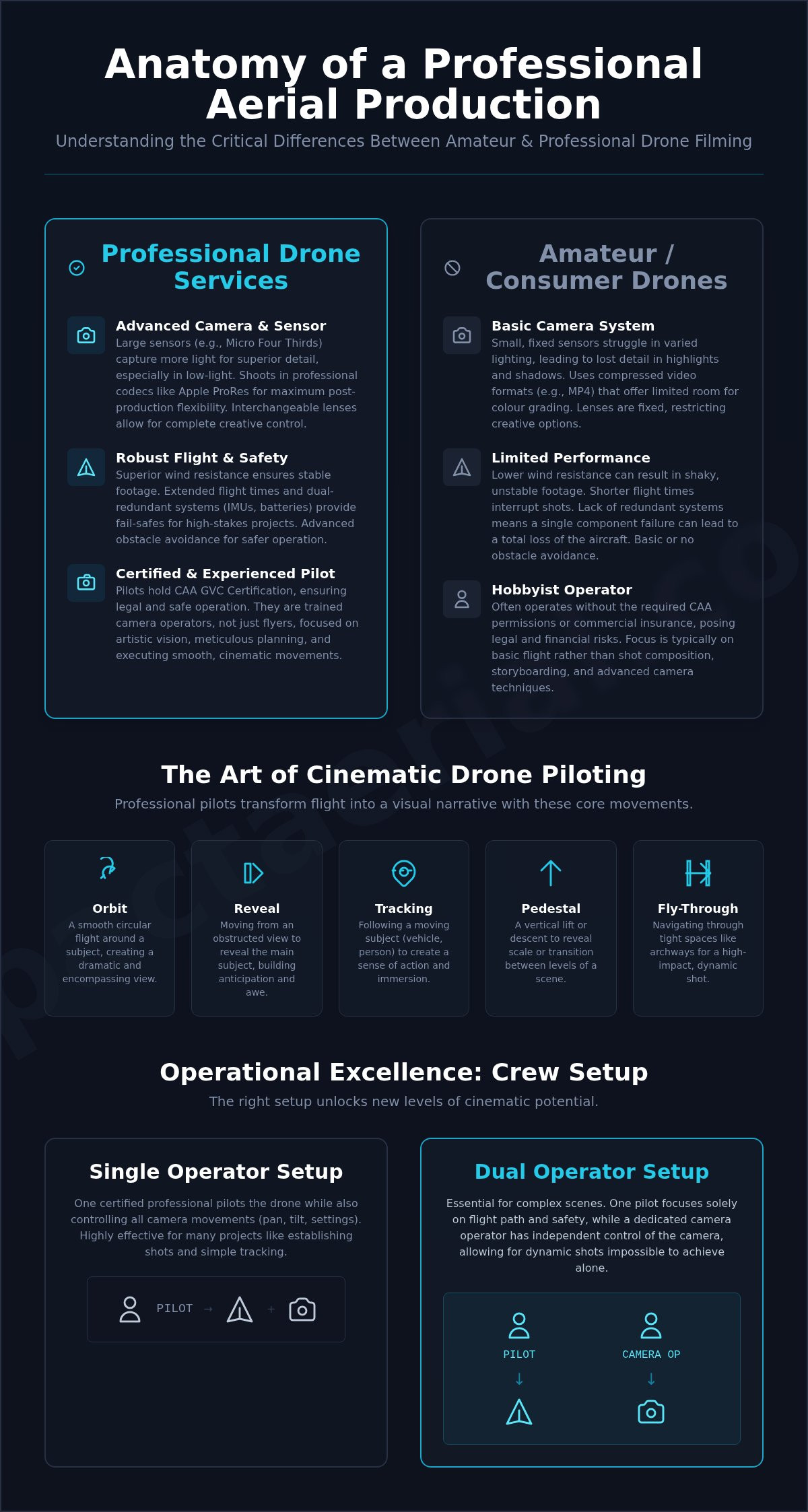
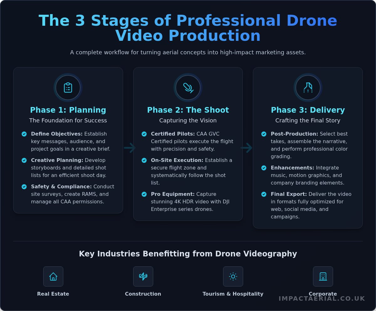
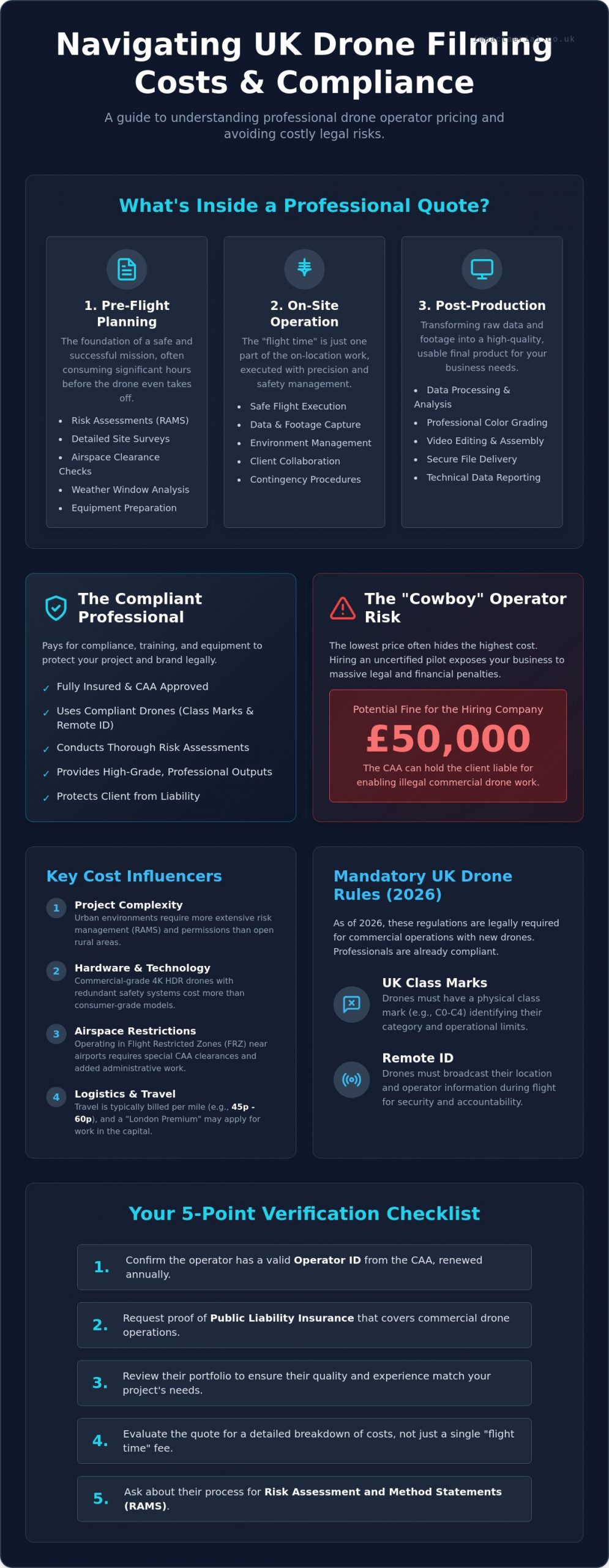
Understanding drone filming prices uk starts with looking beyond the flight time itself. A professional quote integrates three distinct phases: pre-flight planning, on-site operation, and post-production delivery. While a hobbyist might simply turn up and fly, a commercial operator spends significant hours conducting site surveys, checking weather windows, and preparing equipment to ensure every second of footage is usable and safe. The “time on site” you see is often just the tip of the iceberg in a professional workflow.
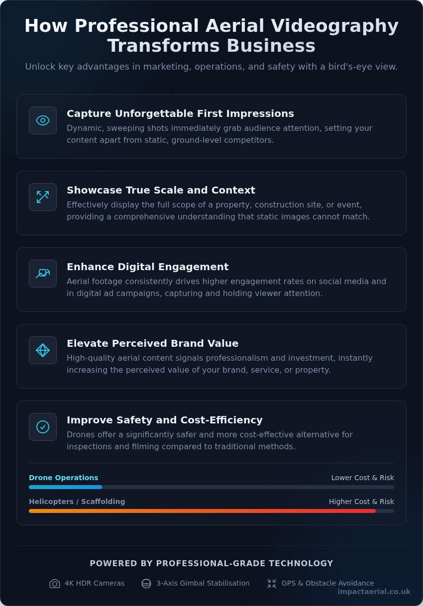
The hardware used also dictates the cost. There is a vast difference between consumer-grade video and the commercial-grade 4K HDR outputs required for high-end broadcast or construction monitoring. Professional Unmanned Aerial Vehicle (UAV) platforms offer better sensors, redundant safety systems, and the ability to capture data-rich files that stand up to professional colour grading. These high-tier outputs ensure that the final product meets the rigorous standards of modern commercial media.
To better understand the regulatory environment that influences these costs, watch this helpful video:
Operational challenges like Flight Restricted Zones (FRZ) add layers of administrative work. If your project sits near an airport or a sensitive government site, the pilot must secure specific CAA clearances before the drone even leaves the ground. This expertise in airspace management is a core component of the value provided by professional services, ensuring your project remains legal and uninterrupted.
Project Complexity and Risk Assessment
Filming in a dense urban environment like Birmingham city centre presents vastly different risks than a rural field in the Cotswolds. Urban shoots require meticulous Risk Assessment and Method Statements (RAMS) to manage pedestrian traffic and nearby structures. We don’t just fly; we manage the environment. Complex airspace permissions or CAA waivers for flying closer to people often require weeks of lead time and technical documentation, which naturally influences the final drone filming prices uk for that specific project.
Regional Logistics and Travel Factors
Geography plays a significant role in your budgeting. Many operators apply a “London Premium” due to the high costs of logistics and congestion within the capital. Conversely, basing operations in the West Midlands allows for more competitive structures while maintaining nationwide reach. Travel expenses are a standard addition, typically charged between 45p and 60p per mile. For long-term projects like construction site monitoring, multi-site contracts can often be negotiated at a more efficient rate than one-off shoots, providing better value over the duration of a build.
The Value of Compliance: Why Professional Pilots Cost More
Choosing an operator based solely on the lowest drone filming prices uk often ignores the hidden costs of non-compliance. As of January 1, 2026, the regulatory landscape has shifted significantly. Every new drone on the market must now carry a UK class mark, and Remote ID must be enabled during flight. These technical requirements aren’t just checkboxes; they’re legal mandates. When you hire a professional, you’re paying for an operator who has invested in compliant hardware and maintains a valid Operator ID, which currently costs £12.34 per year and requires annual renewal.
Hiring an uncertified “cowboy” operator introduces a massive financial risk to your business. The Civil Aviation Authority (CAA) takes illegal commercial work seriously. If a pilot operates without the necessary permissions or insurance, the client can be held liable for enabling the activity. This “Cowboy Risk” can lead to fines reaching £50,000 for the hiring company. Adhering to Civil Aviation Authority (CAA) regulations is the only way to insulate your brand from these legal repercussions. For a deep dive into these requirements, read our guide on the UK Drone License: A Simple Guide to CAA Rules in 2026.
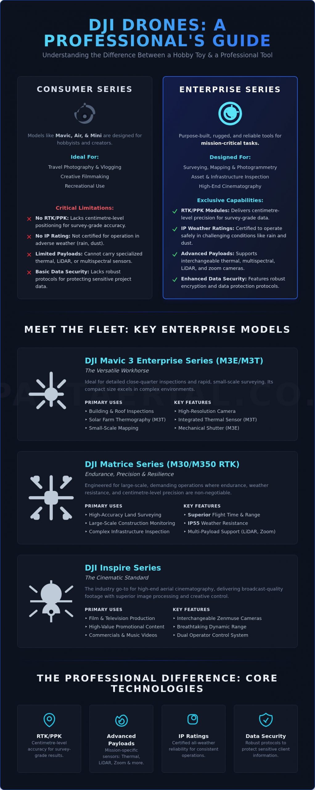
Professional delivery also relies on enterprise-grade equipment. Operators using DJI Enterprise platforms or similar high-end systems provide better reliability and data security than those using consumer drones. These systems are designed for intensive commercial use, featuring redundant batteries and advanced obstacle avoidance. This hardware investment ensures that your project is delivered on time, without technical failures. If you need a partner who prioritises these standards, you can explore our professional aerial filming and photography options.
CAA GVC Certification and Operational Authorisation
The General Visual Line of Sight Certificate (GVC) is the gold standard for modern drone pilots. It proves the operator has undergone rigorous theoretical and practical testing. This certification is a prerequisite for obtaining an Operational Authorisation from the CAA, which allows for flights in more complex environments. Professional training costs and the administrative burden of maintaining these certifications are reflected in the day rate. However, this expertise ensures that emergency procedures are handled with precision, protecting both the public and your site.
Commercial Liability Insurance: The £5m Standard
Standard hobbyist insurance is fundamentally insufficient for commercial projects. Professional pilots carry insurance that is specifically EC 785/2004 compliant, which is the legal minimum for commercial flight in the UK. While some operators offer a basic £1m policy, many high-value commercial sites now require a £5m or even £10m public liability standard. This level of coverage protects the client from third-party claims and property damage, providing a layer of financial security that a budget operator simply cannot offer. This meticulous approach to risk mitigation is what separates a professional service from a risky alternative.
Standard Drone Filming Rate Structures in the UK
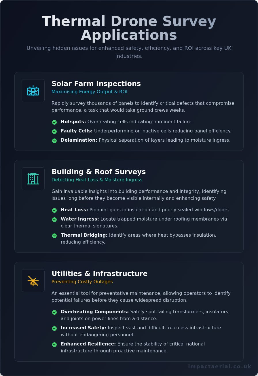
Beyond standard time-based billing, many specialists provide “Project-Based” pricing for complex deliverables. This is particularly common for advanced services like 3D virtual tours or PV solar farm thermal surveys, where the value lies in the technical data produced rather than just the time spent on site. These fixed-fee arrangements give businesses budget certainty for intricate workflows that involve multiple stages of data capture and sophisticated processing.
Hourly vs. Day Rates: Which is Better?
Hourly rates are often the most efficient choice for straightforward tasks that require minimal set-up time. Quick property shots or routine construction site progress updates fall into this category. However, for more intensive projects, a half-day or full-day rate usually offers better value. A full-day booking allows the pilot to capture footage during optimal lighting windows and perform multiple battery cycles without the pressure of a ticking clock. Most professional day rates include the pilot’s expertise, the deployment of a primary and backup drone, basic commercial insurance, and the secure transfer of raw data. This comprehensive package ensures that the operation is resilient against minor technical hitches or changing site conditions.
Post-Production and Data Processing Costs
It’s a common misconception that the project ends when the drone lands. In reality, the post-production phase can sometimes double the base flight cost due to the intensive studio time required. Raw 4K or 5K footage is often flat and requires professional colour grading to meet commercial standards. For technical applications like construction site monitoring or thermal surveys, the data must be processed through specialised software to generate accurate orthomosaics or heat maps. Virtual tour creation is another area where the workload shifts heavily to the studio; stitching 360-degree aerial views into a seamless, interactive experience requires meticulous attention to detail. This studio work is what transforms raw aerial data into a polished, high-end asset that provides tangible business value.
How to Evaluate a Drone Filming Quote
Receiving a technical quote requires a meticulous eye for detail that goes beyond the bottom line. A proposal that seems significantly lower than the standard drone filming prices uk usually signals a compromise in safety, equipment quality, or legal compliance. When you compare operators, you aren’t just buying footage; you’re hiring a risk management specialist. Technical precision is non-negotiable. To ensure you’re making an informed decision, use this 5-point verification checklist before signing any contract:
- CAA Operational Authorisation: Confirm the pilot holds a current OA for the specific category of flight required.
- Specific Insurance: Verify the policy is EC 785/2004 compliant and covers the exact site activity, such as construction site monitoring or thermal surveys.
- Industry-Specific Portfolio: Ensure the operator has experience in your sector; a pilot who excels at property photography may lack the technical rigour needed for commercial property surveys.
- Equipment Redundancy: Ask if the pilot carries backup aircraft to prevent project delays in the event of a technical fault.
- Transparent Deliverables: The quote must clearly define what you receive, including resolution, file formats, and usage rights.
Red flags often hide in what is missing from the paperwork. If an operator is reluctant to provide their Flyer ID or Operator ID, it’s a clear sign of professional negligence. For a more detailed framework on selecting the right partner, consult our A Complete Guide to Professional Drone Services in the UK.
Verifying Pilot Credentials and Insurance
Legitimate operators will proactively offer their credentials. You should request a copy of the pilot’s Flyer ID and the company’s Operator ID to verify their status on the national register. It’s equally vital to see the CAA Operational Authorisation (OA) document. This paperwork outlines the specific conditions under which the pilot can fly, including distance from uninvolved persons. Finally, check that their insurance isn’t just a generic public liability policy but one tailored for commercial drone operations that protects you from third-party claims on your specific site.
Reviewing Deliverables and Turnaround Times
Clarity on the final output prevents budget creep later in the project. Ensure the quote specifies commercial-grade 4K HDR resolution and the exact file formats your editors require. You should also agree on a concrete timeline for data delivery and any included revision cycles. Ownership is another critical factor. A professional quote should explicitly state that you hold the usage rights for the footage, ensuring your marketing or engineering teams can use the assets across all platforms without additional fees. Contact us today to receive a professional drone filming consultation tailored to your specific site requirements.
Impact Aerial: Professional Drone Services with Transparent Value
Impact Aerial bridges the gap between high-end technical precision and accessible drone filming prices uk. By maintaining a strategic operational base in Birmingham, we provide efficient nationwide coverage, reducing travel overheads for clients across the West Midlands and the rest of the UK. Our operations are built on a foundation of strict compliance, featuring a consistent commitment to £5m commercial liability insurance and full CAA GVC certification. This meticulous approach ensures that every project, regardless of scale, is executed within the highest safety and legal frameworks available in 2026.
We exclusively utilise DJI Enterprise drone systems to deliver superior data and visual quality. These platforms offer the technical redundancy and advanced sensor capabilities required for commercial-grade output, ensuring that our clients receive stable, high-resolution assets for every mission. We don’t just provide raw footage; we offer a reliable partnership that prioritises risk mitigation and technical excellence. Our team handles the complex administrative burden of flight planning and airspace permissions, allowing you to focus on your core business objectives while we capture the data you need.
Bespoke Quotes for Diverse Industries
Our pricing models are tailored to the specific demands of the property, construction, and advertising sectors. We understand that a construction site monitoring project requires a different technical approach and risk assessment than a high-end cinematic marketing campaign. Impact Aerial provides an end-to-end service, managing everything from the initial site consultation and RAMS preparation to the final post-production editing. This holistic approach ensures consistency and quality across the entire project lifecycle. For a detailed look at our visual standards and technical capabilities, explore our Aerial Filming Drone: The Ultimate Guide to Professional Cinematic Video.
Get a Professional Drone Filming Quote Today
Securing a transparent and accurate estimate for drone filming prices uk is a straightforward process with our technical team. To provide the most precise quote, we typically require the project location, the intended flight dates, and a brief overview of your required deliverables, such as raw data or fully edited films. Whether you need a one-off aerial survey or recurring construction monitoring, we offer detailed, no-obligation quotes that reflect the true value of professional expertise. Take the first step toward secure, high-end aerial data by choosing a partner that values compliance as much as you do. Request a Quote from Impact Aerial today to discuss your specific project requirements and receive a tailored proposal.
Securing Your Visual Assets with Technical Precision
Mastering drone filming prices uk requires a shift in perspective from viewing aerial work as a commodity to seeing it as a specialized technical service. By prioritizing CAA GVC certified pilots and verifying £5m commercial liability insurance, you protect your business from the significant legal and financial risks of non-compliance. Professional pricing isn’t just a fee for flight time; it’s an investment in meticulous risk management and the high-tier 4K HDR DJI Enterprise technology required for commercial-grade results.
Choosing an operator with transparent rate structures and a proven record in your specific industry ensures that your project is delivered on time and within budget. We provide the technical expertise and regulatory compliance necessary to transform complex aerial data into actionable business assets. You can Get a Professional Drone Filming Quote from Impact Aerial Today to start planning your next project with total confidence. We look forward to helping you achieve your commercial goals through precise, high-end aerial imaging.
Frequently Asked Questions
How much does a drone pilot cost per day in the UK?
Day rates for professional drone pilots depend on the complexity of the mission, the required hardware, and the pilot’s level of certification. A GVC-certified pilot using enterprise-grade equipment provides a comprehensive service that includes pre-flight site surveys, risk assessments, and technical data capture. This rate ensures you’re hiring a specialist who manages all legal and safety requirements, protecting your business from the liabilities associated with unvetted operators.
Do drone filming prices include travel expenses?
Travel expenses are typically calculated as a separate line item based on the distance from the pilot’s operational base. Most UK operators apply a standard mileage rate, often between 45p and 60p per mile, to cover fuel and vehicle maintenance costs. For long-distance projects or multi-day shoots requiring overnight stays, additional subsistence and accommodation fees may be detailed in your bespoke quote to ensure all logistics are covered.
Why is professional drone filming more expensive than a hobbyist?
Professional drone filming prices uk reflect the significant operational overheads required to maintain a legal and safe commercial service. Unlike hobbyists, professional pilots must hold valid CAA certifications, pay for annual Operator IDs, and carry specialist commercial liability insurance. They also invest in high-tier enterprise hardware with redundant safety systems, ensuring technical precision and data security that a recreational flyer cannot provide.
Are there extra costs for filming in London or major city centres?
Filming in dense urban environments like London or Birmingham city centres often incurs higher costs due to increased administrative and safety requirements. These locations frequently sit within Flight Restricted Zones (FRZ) or require specific CAA waivers to operate near people and buildings. The time spent coordinating with Air Traffic Control and local authorities, combined with the need for extra ground crew for pedestrian management, justifies a more complex pricing structure.
Does the price change based on the type of drone used?
The choice of aircraft is a primary factor in determining the final project cost. Operating high-end DJI Enterprise drones with thermal sensors or cinematic 4K HDR cameras requires a higher investment in equipment maintenance and technical training than using standard consumer models. These professional platforms offer the stability, data accuracy, and safety features essential for specialized tasks like construction site monitoring or commercial property surveys.
What is included in a standard drone photography package?
A standard professional package usually includes the pilot’s time, the deployment of a primary and backup aircraft, and the delivery of high-resolution images. Reputable quotes also encompass the pre-flight planning phase, site-specific risk assessments, and a minimum level of commercial insurance. You should receive a clear agreement on the number of final assets provided and the specific usage rights granted for your commercial or technical reports.
How much does it cost to add video editing to a drone shoot?
Post-production fees are generally calculated based on the total studio time required to process the raw data and create a finished film. Adding professional editing involves color grading, sound design, and the integration of your corporate branding or technical graphics. For complex projects, this phase might also include the creation of interactive virtual tours or the processing of thermal data, which requires specialized software and technical expertise.
Is insurance included in the drone filming quote?
Yes, any professional drone filming quote should include EC 785/2004 compliant commercial liability insurance as standard. While a basic £1m policy is common, many high-value commercial sites now require a £5m or £10m standard to mitigate third-party risks. You should always verify that the insurance covers your specific site activities and ask for a copy of the policy to ensure your project is fully protected from third-party claims.