

Night-time aerial filming with a UAV can be planned, but a flight should proceed only when the location, airspace, visibility and safety conditions allow. The shoot also needs close coordination with the production team so the footage serves the scene and fits the schedule.
That balance matters: aerial footage can bring distinctive perspectives to television programmes and films, but safe, usable results depend on preparation as much as camera work. Night shoots call for particular care, so the flight plan, conditions and production needs must be considered together.
This guide explains how aerial filming supports photography and video production, what to consider for night flights, and how pre-flight planning shapes a practical shoot. It also covers equipment, location requirements and operational decisions, helping you prepare before adding UAV footage to a production.
Key Takeaways
- Plan permissions around the location, airspace and take-off and landing arrangements before setting a filming date.
- Match the aerial shots to the production’s visual brief, from establishing views to specific photographic or video sequences.
- Night flights need careful consideration of conditions, visibility and operational safety as part of the wider shoot plan.
- Build pre-flight checks into the schedule: the UK Government’s Air Navigation Order article 241 prohibits recklessly or negligently causing or permitting an aircraft to endanger a person or property.
Do you take aerial photographs?
Yes. Aerial photographs can support campaign imagery, public relations and marketing, while drone video can capture moving shots for broadcast or film. In the UK, the CAA rules that apply depend on the aircraft, operation and location.
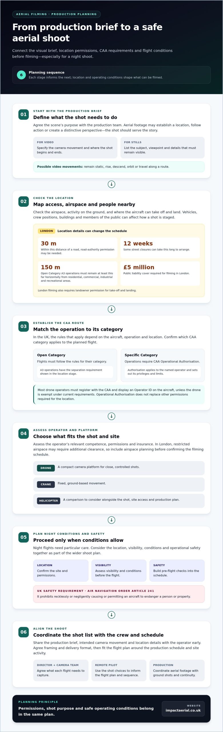
For a commercial shoot, plan around the airspace, people nearby, and take-off and landing locations. Most drone operators must register with the CAA and display an Operator ID on the aircraft, unless the drone is exempt under current requirements. Open Category flights must follow their category rules; Specific Category operations require CAA Operational Authorisation.
Location affects permissions. In London, flights within 30 metres of a road may need road-authority permission, and some street closures can take 12 weeks to arrange. Open Category A3 operations must remain at least 150 metres horizontally from residential, commercial, industrial and recreational areas. Filming in London also requires landowner permission for take-off and landing, and at least £5 million public liability cover is required.
Broadcast and Film Production
For television, commercials, drama and feature films, aerial footage can establish a location, follow action or give a scene a distinctive perspective. Share the production brief, intended camera movement and location details with the operator early, so they can inform the flight plan and shot sequence.
Campaign and PR teams can use still images in press materials, while marketing productions may need coordinated stills and video. Agree the framing and delivery format with the production team before the operation. Commercial aerial filming is one civilian use of drones; property imagery and site records are other applications, each shaped by the purpose and setting of the flight.
Operator and Aircraft Choices
When hiring a UK operator, establish which CAA category applies to the planned flight, then assess the operator’s relevant competence, permissions and insurance. A CAA Operational Authorisation applies to the named operator and sets out its privileges and limits; it does not replace other permissions required for the location.
Compared with helicopters, drones can provide a compact camera platform for close, controlled shots; cranes provide fixed, ground-based movement. The right option depends on the shot, site access and production plan. In London, restricted airspace may require additional clearance, so include airspace planning before confirming the filming schedule.
Aerial filming for television, commercials, drama and feature films
For a television programme, a drone can show how a location connects with its surroundings. In a drama, a controlled approach towards a building can establish the setting before the next scene. Commercials may use a moving aerial view to introduce a product, venue or landscape. The shot should serve the story, not simply add height.
Aerial cinematography starts with the production brief. Identify the scene’s purpose, the required camera movement and where the shot begins and ends. A wide coastline view needs different framing from a tracking shot above a road or a slow reveal over a film set. Share these choices with the remote pilot before the shoot, then fit the flight plan around the production schedule and location.
Commercial filming is one civilian use of unmanned aircraft. Other uses include capturing campaign stills or recording a site for visual documentation. In broadcast and film, the aircraft’s movement, camera angle and background all affect how footage edits alongside ground-based shots. A practical shot list helps the director, camera team and pilot agree what each flight needs to capture.
Airspace and activity on the ground also shape the shoot. Vehicles, crew positions, buildings and members of the public can affect where an aircraft can fly and how a shot is staged. In the UK, CAA rules apply to the drone operation, while location permissions may also be needed. Include these considerations in production planning rather than leaving them until the last minute.
For a production brief that calls for specialist aerial images or footage, professional aerial filming and photography can help turn the intended shots into a coordinated filming plan.
Aerial photography and videography
Aerial photography and video serve different production needs. A still image can provide a campaign’s lead visual, document a property from above or show how a site fits its surroundings. Moving footage can create a sense of direction, revealing a building as the camera passes it. Define the intended use first, then plan the framing and movement around it.
For aerial still photography, give the drone pilot a concise shot list. Include the subject, preferred viewpoint and details that must remain visible, such as an entrance, roofline or surrounding landscape. A high, wide frame can establish context; a lower oblique angle can emphasise a building’s shape. The pilot can then plan a safe position and camera direction for each image.
Drone photography uses an unmanned aircraft, allowing the pilot to position the camera without placing a photographer in the air. But this does not remove the need to plan permissions and the flight operation. The CAA category, location, airspace and people nearby all shape what is practical. For commercial property imagery, agree which elevations and site features the final record must show.
For video, specify whether the shot should remain static, rise, descend, orbit or travel along a route. A slow reveal of a building, for example, may need a clear start and end point to make the movement useful in the edit. Coordinate the shot with ground-based photography and filming so changes in light or site activity do not disrupt continuity.
Before the flight, confirm the shot list, permissions, intended use and delivery requirements with the production team. Separate still-image needs from video requests, and identify essential views. This gives the drone pilot a clear brief and helps the aerial photography serve its purpose, whether for a campaign, production or visual site record.
Flight planning and pre-flight inspections
Plan each mission around its location, airspace, intended shots and people nearby. A practical sequence is to assess the site, prepare the flight plan, inspect the aircraft and review conditions before flying.
Flight Plans and Location Feasibility
Start by identifying the launch and landing points, planned route, obstacles and areas where the public may be present. Check airspace restrictions and location permissions, then decide whether the proposed flight can be carried out safely within the operation’s limits. Flight-planning software can help map routes and record site constraints. Intelligent modes may support repeatable camera movements, but pilots remain responsible for managing the flight.
Pre-Flight Inspections and Risk Assessments
Before take-off, inspect the aircraft, propellers, battery, camera and control equipment for damage or faults. Compare the actual site with the risk assessment, including nearby people, vehicles and changes to the planned operating area. The Air Navigation Order article 241 prohibits recklessly or negligently causing or permitting an aircraft to endanger a person or property, according to the UK Government. Drone operators should not proceed if safety concerns remain.
Weather and Flight Conditions
Review wind, precipitation, cloud and visibility before each flight, then reassess if conditions change. One example pre-flight checklist recommends a precipitation chance below 10%, wind under 15 knots, a cloud base of at least 500 feet and visibility of at least 3 statute miles. These are checklist recommendations, not a universal forecast for every mission. Conditions at the location and the aircraft’s limits inform the pilot’s decision.
For a site-focused operation, explore commercial property drone surveys as part of planning aerial work.
Impact Aerial: Aerial Filming and Photography
Impact Aerial provides Aerial Filming and Photography for productions, campaigns and projects that need professional aerial images or video. Its CAA GVC certified pilots use commercial-grade professional drones equipped with 4K HDR cameras, backed by £5m commercial liability insurance.
Turn to Impact Aerial when you have a defined shot list, filming location or visual brief and need aerial capture planned around the project. The team also provides related services, including Drone Commercial Property Surveys, Construction Site Monitoring and PV Solar Farm Thermal Surveys.
Share your intended shots, location and production needs to discuss how aerial filming and photography could support your project. Contact Impact Aerial for a free, no-obligation quote.
Shape your next shoot around the story
The strongest next step is to turn your creative idea into a clear visual brief. Decide what viewers should notice, where the footage will appear, and how aerial filming with a UAV will support the wider production. A defined purpose helps the aerial material feel considered and gives the production team a useful starting point for shot planning and editing.
Impact Aerial provides Aerial Filming and Photography, alongside PV Solar Farm Thermal Surveys and Drone Commercial Property Surveys. These services support different project needs, from creating visual content to capturing property or solar-site information. When you get in touch, outline the project location, intended use and key requirements.
Contact Impact Aerial to discuss your project and plan a practical next step. A well-shaped brief can help your team move forward with confidence.
Frequently Asked Questions
Can you fly at night?
Yes, night flights can be planned when the operator can meet applicable aviation rules and safe operating conditions. An aerial-filming UAV plan should account for visibility, the launch and landing area, airspace, nearby activity and crew coordination. For example, a production filming after dark should agree shot positions and communication procedures before take-off, rather than adapting the plan mid-flight.
Can you fly over water?
Yes, a drone can be used for aerial filming over water when the route and recovery plan suit the location. The pilot should consider where the aircraft can take off and land, how far the shot extends from shore, and how to end the flight safely if the plan needs to change. Water reflections can also affect exposure, so test framing and camera settings before recording key footage.
How does weather affect flight operations?
Weather affects flight conditions and the quality of footage. Wind can make a planned camera movement less steady, while rain can affect visibility and equipment. Before a coastal shoot, for example, review the local forecast and observe conditions at the launch site. Reassess if the weather changes and adapt the shot plan to the conditions.
How long can you fly for?
Flight time depends on the aircraft, battery condition, weather, route and camera workload. A close, simple shot may need a different plan from a longer tracking sequence across a site. Plan each mission around the required footage, allowing for positioning and a safe return. For a production, divide a complex sequence into separately planned shots rather than relying on one uninterrupted flight.
How much do you charge?
The price depends on the project and is provided after a quote request. Factors include the location, filming requirements, operational planning and any post-production work needed. A straightforward set of still images has different requirements from a multi-shot film sequence involving several locations. Impact Aerial offers a free, no-obligation quote, so you can outline the intended use and receive project-specific pricing.
How safe is it?
Safe operation depends on planning, competent piloting and responding to conditions at the location. For example, a filming site with moving vehicles or members of the public needs clear separation from the aircraft’s operating area. The pilot assesses risks before flight and monitors the operation as it progresses. If site conditions change, the plan should be adjusted to protect people and property.
 2 Norton Drive, Wythall, Birmingham, B47 6HH Company registration number: 11138586. VAT Number: 366 9068 55


