How to Vet a Commercial Drone Company: A Professional Buyer’s Guide for 2026

Hiring the wrong drone operator in 2026 is no longer just a matter of receiving poor-quality footage; it’s a significant legal and financial liability for your business. With the UK’s transitional period for legacy drones now officially over, the regulatory landscape has become a complex minefield for the uninitiated. You likely feel the pressure to secure high-accuracy survey data or cinematic 4K visuals while fearing that a single compliance oversight could void your corporate insurance. Learning exactly how to vet a commercial drone company is the only way to protect your budget and your reputation in an industry that now demands absolute technical precision.

We’ve designed this professional buyer’s guide to strip away the confusion surrounding CAA terminology and the latest UK class mark requirements. You’ll learn the exact technical, safety, and regulatory criteria needed to hire a compliant operator who delivers reliable results rather than excuses. We’ll walk through the essential documentation you must request, from valid Operator IDs to specific liability coverage, ensuring your next project is backed by expert-level risk mitigation and high-end data quality.

Key Takeaways

  • Understand the critical legal distinction between an Operator ID and a Flyer ID to ensure your provider is correctly registered on the CAA national database.
  • Identify the specific technical qualifications, such as the General Visual Line of Sight Certificate (GVC), required for complex or high-risk commercial operations.
  • Discover how to vet a commercial drone company by evaluating their industry-specific hardware and their ability to deliver technical data like Ground Sample Distance (GSD).
  • Learn why mandatory safety documentation, including a site-specific Risk Assessment and Method Statement (RAMS), is non-negotiable for maintaining corporate insurance compliance.
  • Utilize a professional 10-point checklist to streamline your procurement process and guarantee high-accuracy survey data or cinematic 4K footage.

The Regulatory Baseline: Verifying CAA Compliance and Insurance

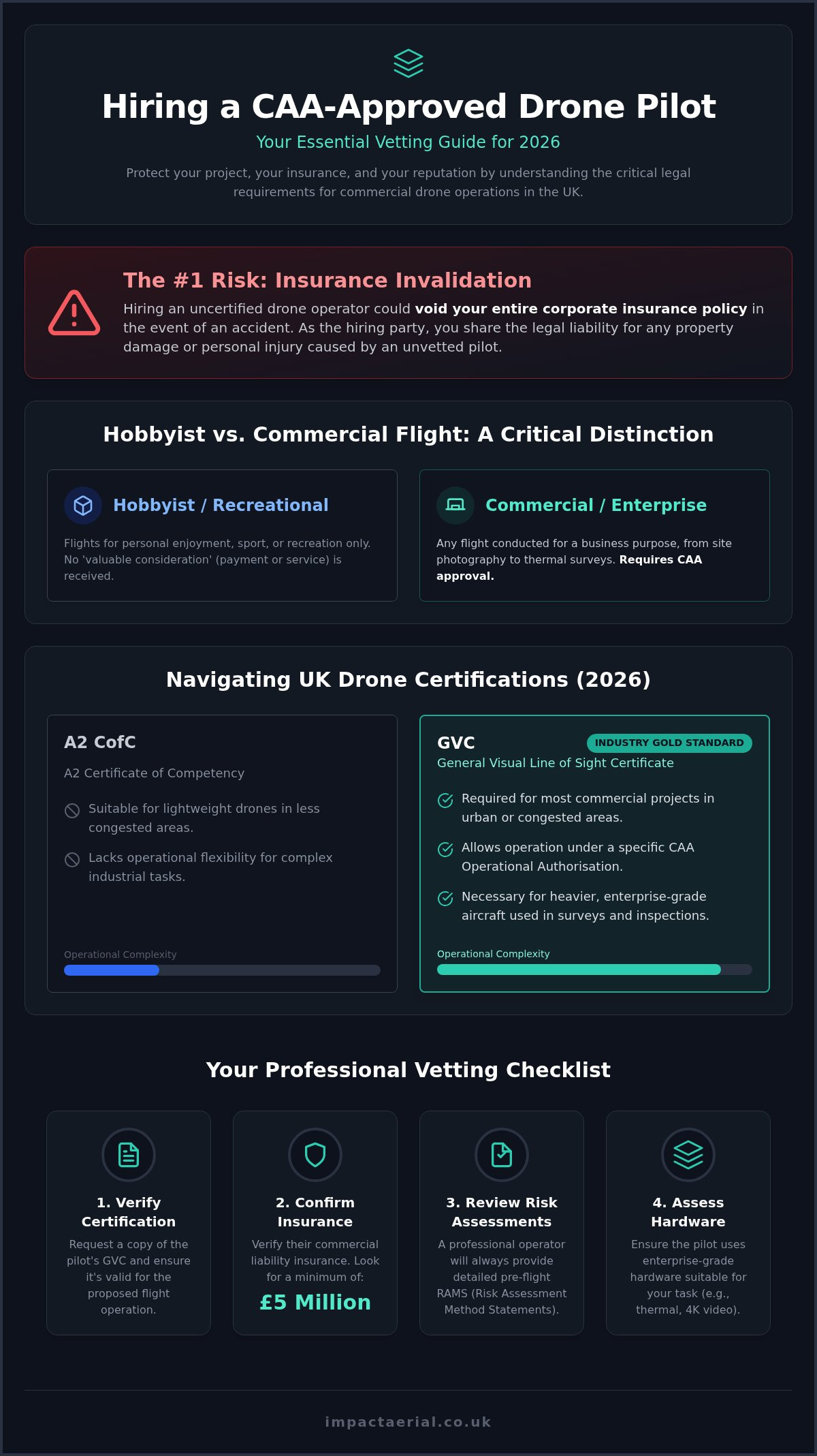
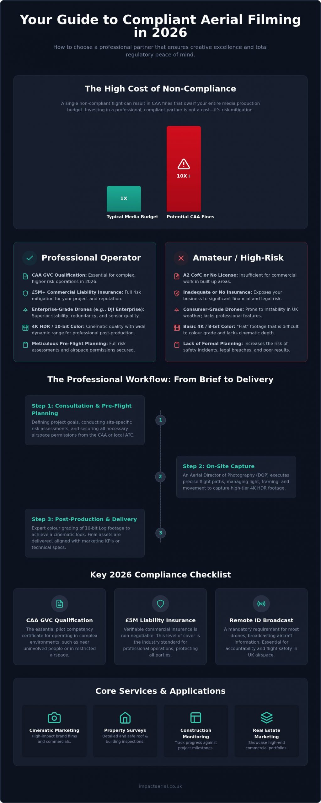
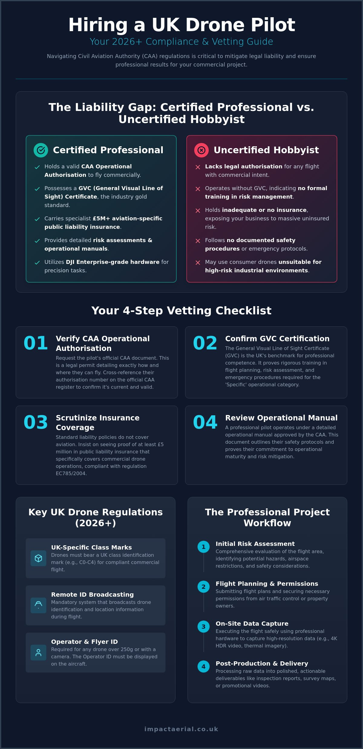
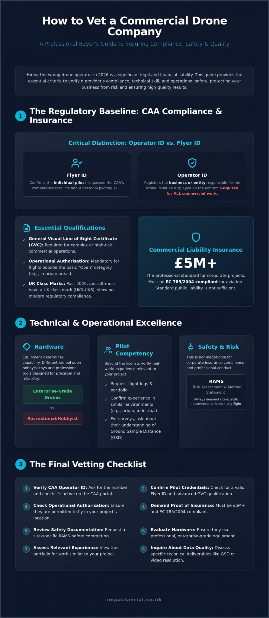
Compliance is the bedrock of professional aerial work. When you set out to learn how to vet a commercial drone company, your first step must be confirming that the provider exists legally within the Civil Aviation Authority (CAA) framework. There’s a critical distinction between an Operator ID and a Flyer ID. The Operator ID is the registration for the business entity responsible for the aircraft, while the Flyer ID confirms the individual pilot has passed the necessary competency tests. Understanding these global drone regulations ensures you aren’t accidentally hiring a hobbyist masquerading as a professional.

Vetting also requires checking for a valid Operational Authorisation on the CAA register. This document is essential for any flight that falls outside the basic “Open” category, such as work in congested urban areas or near industrial infrastructure. While older PfCO (Permission for Commercial Operations) qualifications have largely been replaced by the General Visual Line of Sight Certificate (GVC), you must verify that your pilot’s credentials are current. As of January 1, 2026, the UK has fully transitioned away from legacy drone categories; all new aircraft must carry a UK class mark from UK0 to UK6. Hiring an operator who doesn’t understand these transitions exposes your business to significant legal risk.

To better understand the level of professionalism required in this industry, watch this helpful video:

Validating the CAA Operator ID

A legitimate company will provide their Operator ID upon request. You can verify this number directly through the CAA’s official portal to ensure it remains active and linked to the correct business entity. By law, this Operator ID must be physically displayed on the aircraft in a clear, readable format. If a pilot claims they don’t need an ID because their drone weighs less than 250g, treat this as a major red flag. In a commercial context, any drone equipped with a sensor capable of capturing personal data requires a valid Operator ID, regardless of its weight.

Commercial Liability Insurance: The £5m Standard

Standard public liability insurance is rarely sufficient for the unique risks of aerial work. Professional operators must carry insurance that is specifically compliant with EC 785/2004, which is the legal standard for aviation insurance in the UK. Impact Aerial maintains a £5m commercial liability baseline to provide maximum peace of mind for our clients. Always verify that a provider’s policy covers the specific environment of your project, whether that involves a high-risk construction site or a city centre property survey. This level of coverage is a primary indicator of how to vet a commercial drone company for corporate-level reliability.

Technical Competency: Evaluating Pilot Skills and Hardware

Compliance ensures an operator is legal, but technical competency ensures they are capable. A pilot’s ability to capture high-accuracy survey data or cinematic 4K footage depends on a combination of advanced flight qualifications and specialized hardware. When you look at how to vet a commercial drone company, you must look beyond the basic flyer ID. True technical proficiency is demonstrated through sector-specific experience and the use of enterprise-grade equipment designed for precision rather than recreation.

Industry experts suggest that evaluating pilot skills requires a deep dive into flight logs and previous mission profiles. A pilot who primarily shoots rural landscapes may lack the spatial awareness required for complex structural inspections in dense urban environments like Birmingham. You should request proof of flight hours in similar settings to ensure the team can safely manage the unique risks of your specific site.

The GVC Certification Advantage

The General Visual Line of Sight Certificate (GVC) is the professional standard for drone operations in the UK. This qualification is more rigorous than basic online tests; it requires a formal practical flight assessment and a detailed operations manual. Holding a GVC allows a pilot to operate in the “Specific” category, which provides the legal flexibility to fly closer to people and property than hobbyist rules allow. For a detailed breakdown of these requirements, consult our UK Drone License guide.

Commercial-Grade Hardware Requirements

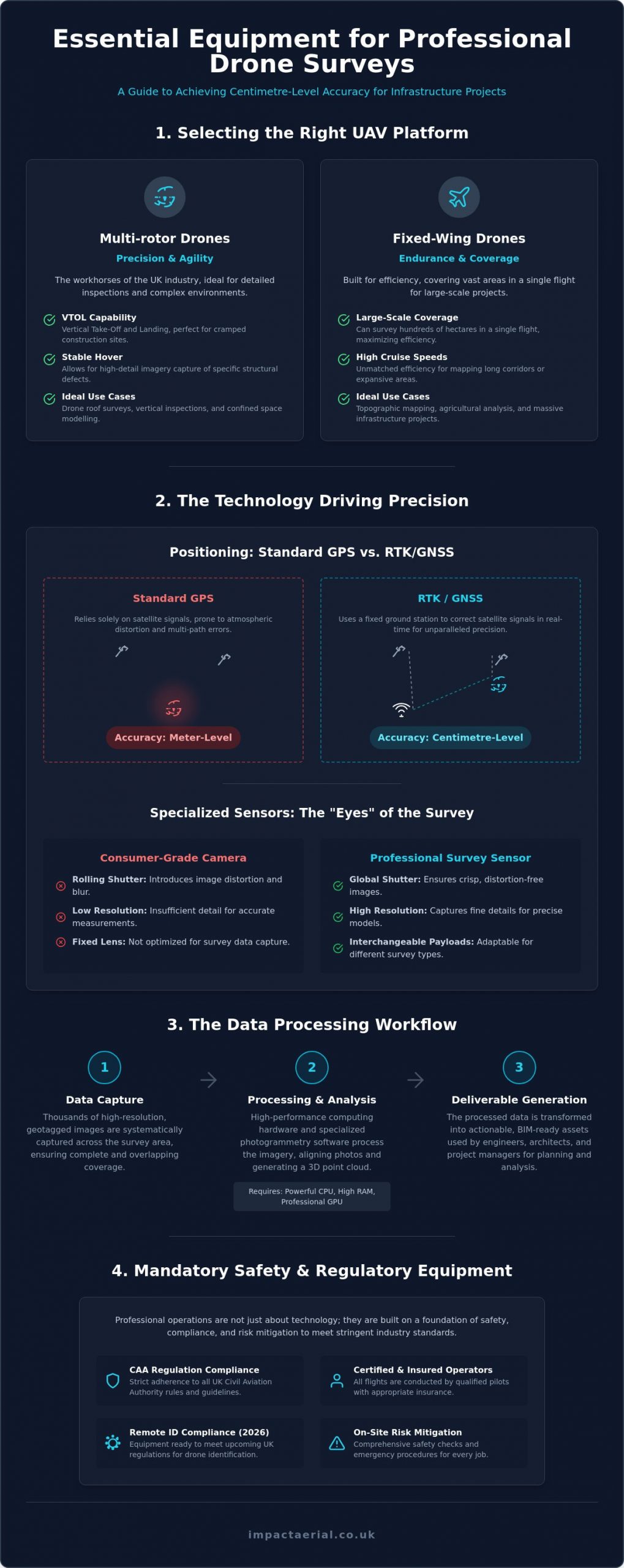
Professional results require professional tools. There is a vast difference between consumer drones and the DJI Enterprise hardware used by specialists. Impact Aerial utilizes advanced platforms like the DJI Matrice 350 RTK for technical surveys and the DJI Inspire 3 for high-end cinematic work. These systems offer features that consumer models lack:

  • Redundancy: Dual-battery systems and multiple inertial measurement units (IMUs) ensure the drone stays airborne even if a component fails.
  • Sensor Quality: 4K HDR cameras provide the dynamic range needed for professional post-production, while thermal sensors are essential for PV solar farm surveys.
  • Safety Systems: 360-degree obstacle avoidance and built-in ADS-B receivers allow pilots to detect and avoid manned aircraft in real-time.

Redundancy isn’t optional for corporate projects. If you need reliable data for construction site monitoring, ensure your provider isn’t relying on consumer-grade “prosumer” drones that lack these critical safety and precision features.

How to Vet a Commercial Drone Company: A Professional Buyer’s Guide for 2026

Industry-Specific Expertise: Surveys vs. Creative Filming

A common mistake during procurement is assuming a drone is simply a flying camera. While the underlying technology is similar, the skillset required for a technical roof inspection is fundamentally different from that of a high-end marketing film. When you look at how to vet a commercial drone company, you must evaluate their specific experience in your required sector. A pilot who excels at sweeping cinematic shots may not understand the rigorous overlap and metadata requirements needed for accurate photogrammetry or topographical mapping.

For technical applications, vetting for data accuracy is paramount. You should ask potential providers about their Ground Sample Distance (GSD) capabilities. GSD represents the distance between the centres of two consecutive pixels measured on the ground; the lower the GSD, the higher the spatial resolution of the data. Professional standards, such as the FAA requirements for commercial drone pilots in the United States, mirror the UK’s own rigorous CAA certification process, emphasizing that commercial flight is a global professional standard requiring specific technical knowledge. High-accuracy survey data relies on this technical understanding of sensor resolution and flight altitude.

Vetting for Commercial Property Surveys

When reviewing a drone survey portfolio, look for consistency in image clarity and comprehensive coverage. A professional survey should include detailed metadata and sufficient image overlap to create high-resolution orthomosaics or 3D models. If you require specialized work, such as PV solar farm thermal surveys, ensure the company holds specific thermography certifications. They should also demonstrate how they integrate aerial data with other technologies, such as 3D virtual tours, to provide a complete view of the asset.

Vetting for Aerial Filming and Marketing

Creative vetting requires a different approach. Evaluate the company’s showreel not just for “cool shots,” but for smooth gimbal movement, professional colour science, and cinematic composition. Stability is key; any micro-jitters in the footage indicate poor hardware or lack of pilot skill. You should also consult our aerial filming drone guide to understand the cinematic standards expected in 2026. Ask whether the company provides end-to-end service, including post-production editing and colour grading, or if they only deliver raw files.

The vetting process shouldn’t end when the drone lands. You need to know how the data will be processed and delivered. A professional firm provides a complete solution, from initial risk assessment and flight planning to the delivery of actionable data or a polished final film. Ensure your chosen partner has the internal infrastructure to handle large 4K or 8K data sets and the technical expertise to translate that data into the specific formats your business requires.

Operational Safety and Risk Management (RAMS)

Safety is not just about avoiding accidents; it’s about systematic risk mitigation that protects your business from legal exposure. When considering how to vet a commercial drone company, you must evaluate their operational workflow before the drone even leaves its case. A professional operator treats every flight as a high-stakes aviation mission, requiring meticulous planning and clear communication protocols. This stage of the vetting process reveals the difference between a casual flyer and a technical specialist who understands the gravity of corporate liability.

Pre-flight planning starts days before the site visit. An expert team will assess the local airspace for permanent or temporary restrictions, identify ground hazards like overhead power lines, and monitor weather trends that could impact flight stability. On the day of the operation, the pilot in command must manage the site environment effectively. This includes establishing a “sterile area” for takeoff and landing and ensuring all site staff are briefed on the flight plan. They must also have a clear strategy for managing onlookers or members of the public who may enter the flight zone unexpectedly.

Emergency procedures are a vital component of professional vetting. You should ask your provider about their “Plan B” for various scenarios. What happens if there is a sudden equipment failure or an unauthorized aircraft enters the airspace? A compliant company has documented procedures for these events, ensuring the pilot can react instantly to maintain safety. This level of preparation is what guarantees a risk-free hiring process and ensures your corporate insurance remains valid throughout the project.

What a Professional RAMS Document Looks Like

A site-specific Risk Assessment and Method Statement (RAMS) is the most important document you will receive during the procurement phase. Unlike generic templates that some low-cost operators use, a professional RAMS is tailored specifically to your project location. It should include a detailed site map, specific identified hazards, clear mitigation steps, and emergency contact details for local authorities. You must review and sign off on the RAMS before any work begins to ensure all parties are aligned on the safety protocols and operational boundaries.

Airspace Management and Permissions

Managing the sky is as complex as managing the ground. Professional operators have the expertise to secure a Notice to Airmen (NOTAM) if the mission requires it, alerting other pilots in the vicinity to their presence. If your project is located near an airport or within a Restricted Area, the company must demonstrate their ability to coordinate directly with Air Traffic Control (ATC). They may also utilize trained ground observers to maintain a 360-degree view of the airspace, providing an extra layer of protection against mid-air incursions.

This level of meticulous planning ensures that your project remains compliant, safe, and efficient. If you require a partner that prioritizes safety and regulatory adherence above all else, contact Impact Aerial for a professional consultation on your next aerial project.

The Final Vetting Checklist: Impact Aerial’s Professional Standard

Vetting a drone provider shouldn’t be a guessing game that leaves your business exposed to legal or financial risk. By this stage, you understand that regulatory compliance is merely the entry requirement and that true value lies in technical precision and operational safety. When you finalize your decision on how to vet a commercial drone company, you need a structured framework to ensure no detail is overlooked. A transparent quote should always be comprehensive, accounting for insurance, complex airspace planning, and the final post-production phase to avoid hidden costs later in the project.

Impact Aerial provides this framework through our own meticulous operational standards. We believe that professional buyers deserve absolute clarity before a single propeller turns. Testing a company’s expertise through an initial consultation is the most effective way to gauge their problem-solving abilities and technical depth. A provider that cannot explain their specific ATC coordination strategy or the Ground Sample Distance of their sensors is unlikely to deliver the high-accuracy results your corporate standards demand.

The 10-Point Commercial Drone Vetting Checklist

Use this scannable list during your procurement process to guarantee your chosen partner meets the 2026 industry standards for safety and quality:

  • Valid CAA Operator ID: Is the business registered and is the ID displayed on the aircraft?
  • GVC Certified Pilots: Do the pilots hold the General Visual Line of Sight Certificate for complex work?
  • £5m+ Insurance: Does the policy meet EC 785/2004 standards with adequate liability limits?
  • Site-Specific RAMS: Have you received a Risk Assessment and Method Statement tailored to your location?
  • Industry-Specific Portfolio: Can they show previous success in your specific sector, such as construction or thermal surveys?
  • Enterprise-Grade Hardware: Are they using stabilized, redundant systems like DJI Enterprise models with 2026-compliant UK class marks?
  • Clear Data Delivery Timeline: Is there a documented schedule for when you will receive your files?
  • ATC/Airspace Planning: Is the coordination with Air Traffic Control and local authorities included in the service?
  • Post-Production Capabilities: Does the company offer in-house editing, colour grading, or data analysis?
  • Professional Body Memberships: Are they affiliated with recognized industry registers or trade associations?

Choosing Impact Aerial for Your Next Project

Our Birmingham-based team of experts handles the entire vetting process for you, ensuring every flight is conducted with surgical precision. We manage the complex administrative burden of airspace permissions and safety documentation, allowing you to focus on your core business objectives. Whether you require high-accuracy survey data or cinematic 4K HDR marketing visuals, our commitment to safety and quality is absolute. Contact us today for a tailored drone services consultation and discover why we are the preferred partner for UK-wide commercial projects.

Elevate Your Operational Standards for 2026

Mastering how to vet a commercial drone company is the difference between a successful project and a significant legal liability. You now have the framework to distinguish between hobbyist operators and technical specialists who prioritize safety, precision, and regulatory adherence. By insisting on CAA GVC Certified Pilots and verifying £5m Commercial Liability Insurance, you protect your corporate interests and ensure the highest quality results. Technical excellence isn’t just about the pilot’s skill; it’s about the reliability of DJI Enterprise Hardware and the meticulous execution of site-specific risk assessments.

Don’t leave your next project to chance. A risk-free hiring process starts with choosing a partner that treats every flight as a critical aviation mission. Whether you require high-accuracy survey data or cinematic marketing footage, we’re here to provide the expert-level compliance your business demands. Take the final step in your procurement process and Request a Professional Drone Service Quote from Impact Aerial to secure your next project with industry-leading standards. We look forward to helping you achieve your goals with technical excellence and absolute reliability.

Frequently Asked Questions

Do I need a drone license to hire a commercial drone company?

You don’t need a personal license to hire a provider. However, the company you hire must hold a valid CAA Operator ID and the individual pilot must possess a Flyer ID. Part of learning how to vet a commercial drone company is ensuring they have the correct Operational Authorisation for the specific mission. The legal responsibility for flight safety and compliance rests entirely with the drone operator, not the client.

What insurance should a professional drone company have?

A professional provider must hold aviation-specific liability insurance that is compliant with EC 785/2004. Standard business public liability policies often exclude aviation activities, leaving you exposed to significant risk. Most corporate clients require a minimum of £1 million in coverage, though higher-risk sites like construction or industrial plants often demand £5 million or more. Always request a Certificate of Insurance that names your company as an additional insured for the project.

How much does it cost to hire a commercial drone pilot in the UK?

Pricing for professional drone services is typically based on the complexity of the operation, the specialized hardware required, and the volume of post-production data processing. A cinematic marketing film has different resource requirements than a technical PV solar farm thermal survey. When you evaluate how to vet a commercial drone company, look for transparent quotes that include all pre-flight planning, insurance, and data delivery fees rather than just a basic hourly rate.

What is a CAA GVC certification and why does it matter?

The GVC, or General Visual Line of Sight Certificate, is the professional standard for drone pilots operating in the UK’s “Specific” category. It replaced the older PfCO and requires a formal theory exam and a practical flight assessment. This certification is vital because it grants the pilot the legal authority to fly closer to people and property in urban environments. It demonstrates that the pilot has reached a verified level of competency and safety management.

Can drones fly in rain or high winds for commercial surveys?

Professional enterprise drones like the DJI Matrice 350 RTK have high IP ratings for moisture resistance and can handle wind speeds up to 12 metres per second. However, heavy rain or extreme gusts usually require the flight to be rescheduled to protect data quality and operational safety. High-accuracy surveys require stable conditions to ensure the sensors capture clear, usable imagery without motion blur or sensor interference that could compromise the final data set.

What happens if a drone crashes during a shoot on my site?

If an incident occurs, the pilot follows the emergency protocols outlined in the site-specific RAMS document. A professional company’s EC 785/2004 compliant insurance will cover third-party property damage or injury. The operator is also required to report certain incidents to the CAA and the Air Accidents Investigation Branch. This structured response is why vetting for robust insurance and safety procedures is non-negotiable for corporate risk management and protecting your business reputation.

How long does it take to get the data back from a drone survey?

Delivery timelines depend on the level of post-production required. Raw 4K footage or basic inspection photos are often available within 24 hours of the flight. More complex outputs, such as processed 3D models or topographical surveys, typically require 48 to 72 hours for data stitching and quality checks. A professional firm will provide a clear delivery schedule as part of their initial quote so you can plan your project milestones with absolute confidence.

Do I need to notify the police if I hire a drone company?

You generally don’t need to notify the police for standard commercial flights on private property. The drone operator is responsible for all necessary permissions, including coordinating with Air Traffic Control if the site is within a Flight Restriction Zone. In some sensitive urban areas, the pilot may inform the local police as a courtesy to prevent public concern, but this is managed entirely as part of their standard pre-flight planning and risk mitigation process.

Drone Filming Prices UK 2026: The Complete Budgeting & Hiring Guide

Hiring the cheapest drone operator isn’t just a budget risk; it’s a legal liability that could cost your business far more than the actual filming fee. You’ve likely encountered a confusing range of drone filming prices uk while planning your project, making it difficult to distinguish between a technical expert and an unvetted hobbyist. It’s natural to feel concerned about hidden costs or the validity of a pilot’s insurance, especially with the strict CAA regulations now in effect for 2026.

We understand that you need more than just high-end visuals; you require technical precision and full regulatory compliance to protect your brand. This guide will help you master the complexities of professional drone pricing, ensuring you know exactly what a fair market rate looks like for specialist aerial work. We’ll preview the essential safety standards, such as mandatory UK class marks and Remote ID requirements, while providing a clear framework to verify pilot credentials and secure a fully insured, compliant service with total confidence.

Key Takeaways

  • Understand the core components of a professional quote, from pre-flight risk assessments to the final delivery of technical data and visuals.
  • Learn how the 2026 UK drone regulations, including mandatory class marks and Remote ID, impact the selection and cost of a legal operator.
  • Master the different billing structures for drone filming prices uk, including hourly rates for quick shoots and project-based fees for complex surveys.
  • Use our 5-point verification checklist to spot red flags and ensure your chosen pilot is fully CAA compliant and insured.
  • Discover how to balance budget with quality by hiring specialists who offer transparent value through meticulous operational standards.

What Influences Drone Filming Prices in the UK?

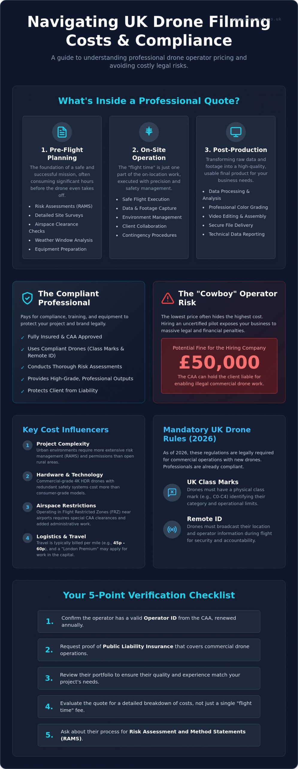
Understanding drone filming prices uk starts with looking beyond the flight time itself. A professional quote integrates three distinct phases: pre-flight planning, on-site operation, and post-production delivery. While a hobbyist might simply turn up and fly, a commercial operator spends significant hours conducting site surveys, checking weather windows, and preparing equipment to ensure every second of footage is usable and safe. The “time on site” you see is often just the tip of the iceberg in a professional workflow.

The hardware used also dictates the cost. There is a vast difference between consumer-grade video and the commercial-grade 4K HDR outputs required for high-end broadcast or construction monitoring. Professional Unmanned Aerial Vehicle (UAV) platforms offer better sensors, redundant safety systems, and the ability to capture data-rich files that stand up to professional colour grading. These high-tier outputs ensure that the final product meets the rigorous standards of modern commercial media.

To better understand the regulatory environment that influences these costs, watch this helpful video:

Operational challenges like Flight Restricted Zones (FRZ) add layers of administrative work. If your project sits near an airport or a sensitive government site, the pilot must secure specific CAA clearances before the drone even leaves the ground. This expertise in airspace management is a core component of the value provided by professional services, ensuring your project remains legal and uninterrupted.

Project Complexity and Risk Assessment

Filming in a dense urban environment like Birmingham city centre presents vastly different risks than a rural field in the Cotswolds. Urban shoots require meticulous Risk Assessment and Method Statements (RAMS) to manage pedestrian traffic and nearby structures. We don’t just fly; we manage the environment. Complex airspace permissions or CAA waivers for flying closer to people often require weeks of lead time and technical documentation, which naturally influences the final drone filming prices uk for that specific project.

Regional Logistics and Travel Factors

Geography plays a significant role in your budgeting. Many operators apply a “London Premium” due to the high costs of logistics and congestion within the capital. Conversely, basing operations in the West Midlands allows for more competitive structures while maintaining nationwide reach. Travel expenses are a standard addition, typically charged between 45p and 60p per mile. For long-term projects like construction site monitoring, multi-site contracts can often be negotiated at a more efficient rate than one-off shoots, providing better value over the duration of a build.

The Value of Compliance: Why Professional Pilots Cost More

Choosing an operator based solely on the lowest drone filming prices uk often ignores the hidden costs of non-compliance. As of January 1, 2026, the regulatory landscape has shifted significantly. Every new drone on the market must now carry a UK class mark, and Remote ID must be enabled during flight. These technical requirements aren’t just checkboxes; they’re legal mandates. When you hire a professional, you’re paying for an operator who has invested in compliant hardware and maintains a valid Operator ID, which currently costs £12.34 per year and requires annual renewal.

Hiring an uncertified “cowboy” operator introduces a massive financial risk to your business. The Civil Aviation Authority (CAA) takes illegal commercial work seriously. If a pilot operates without the necessary permissions or insurance, the client can be held liable for enabling the activity. This “Cowboy Risk” can lead to fines reaching £50,000 for the hiring company. Adhering to Civil Aviation Authority (CAA) regulations is the only way to insulate your brand from these legal repercussions. For a deep dive into these requirements, read our guide on the UK Drone License: A Simple Guide to CAA Rules in 2026.

Professional delivery also relies on enterprise-grade equipment. Operators using DJI Enterprise platforms or similar high-end systems provide better reliability and data security than those using consumer drones. These systems are designed for intensive commercial use, featuring redundant batteries and advanced obstacle avoidance. This hardware investment ensures that your project is delivered on time, without technical failures. If you need a partner who prioritises these standards, you can explore our professional aerial filming and photography options.

CAA GVC Certification and Operational Authorisation

The General Visual Line of Sight Certificate (GVC) is the gold standard for modern drone pilots. It proves the operator has undergone rigorous theoretical and practical testing. This certification is a prerequisite for obtaining an Operational Authorisation from the CAA, which allows for flights in more complex environments. Professional training costs and the administrative burden of maintaining these certifications are reflected in the day rate. However, this expertise ensures that emergency procedures are handled with precision, protecting both the public and your site.

Commercial Liability Insurance: The £5m Standard

Standard hobbyist insurance is fundamentally insufficient for commercial projects. Professional pilots carry insurance that is specifically EC 785/2004 compliant, which is the legal minimum for commercial flight in the UK. While some operators offer a basic £1m policy, many high-value commercial sites now require a £5m or even £10m public liability standard. This level of coverage protects the client from third-party claims and property damage, providing a layer of financial security that a budget operator simply cannot offer. This meticulous approach to risk mitigation is what separates a professional service from a risky alternative.

Drone Filming Prices UK 2026: The Complete Budgeting & Hiring Guide

Standard Drone Filming Rate Structures in the UK

Professional operators typically categorise their services into three primary billing models to ensure transparency and operational clarity. These structures allow clients to align their specific project goals with the necessary level of technical expertise and hardware. When evaluating drone filming prices uk, you’ll find that most reputable firms offer hourly, half-day, and full-day options. This tiered approach provides flexibility for everything from rapid asset inspections to multi-day cinematic productions. A GVC-certified pilot operating enterprise-grade hardware typically commands a professional day rate that reflects the significant investment in technical training, high-tier equipment, and the comprehensive commercial insurance required for safe operation.

Beyond standard time-based billing, many specialists provide “Project-Based” pricing for complex deliverables. This is particularly common for advanced services like 3D virtual tours or PV solar farm thermal surveys, where the value lies in the technical data produced rather than just the time spent on site. These fixed-fee arrangements give businesses budget certainty for intricate workflows that involve multiple stages of data capture and sophisticated processing.

Hourly vs. Day Rates: Which is Better?

Hourly rates are often the most efficient choice for straightforward tasks that require minimal set-up time. Quick property shots or routine construction site progress updates fall into this category. However, for more intensive projects, a half-day or full-day rate usually offers better value. A full-day booking allows the pilot to capture footage during optimal lighting windows and perform multiple battery cycles without the pressure of a ticking clock. Most professional day rates include the pilot’s expertise, the deployment of a primary and backup drone, basic commercial insurance, and the secure transfer of raw data. This comprehensive package ensures that the operation is resilient against minor technical hitches or changing site conditions.

Post-Production and Data Processing Costs

It’s a common misconception that the project ends when the drone lands. In reality, the post-production phase can sometimes double the base flight cost due to the intensive studio time required. Raw 4K or 5K footage is often flat and requires professional colour grading to meet commercial standards. For technical applications like construction site monitoring or thermal surveys, the data must be processed through specialised software to generate accurate orthomosaics or heat maps. Virtual tour creation is another area where the workload shifts heavily to the studio; stitching 360-degree aerial views into a seamless, interactive experience requires meticulous attention to detail. This studio work is what transforms raw aerial data into a polished, high-end asset that provides tangible business value.

How to Evaluate a Drone Filming Quote

Receiving a technical quote requires a meticulous eye for detail that goes beyond the bottom line. A proposal that seems significantly lower than the standard drone filming prices uk usually signals a compromise in safety, equipment quality, or legal compliance. When you compare operators, you aren’t just buying footage; you’re hiring a risk management specialist. Technical precision is non-negotiable. To ensure you’re making an informed decision, use this 5-point verification checklist before signing any contract:

  • CAA Operational Authorisation: Confirm the pilot holds a current OA for the specific category of flight required.
  • Specific Insurance: Verify the policy is EC 785/2004 compliant and covers the exact site activity, such as construction site monitoring or thermal surveys.
  • Industry-Specific Portfolio: Ensure the operator has experience in your sector; a pilot who excels at property photography may lack the technical rigour needed for commercial property surveys.
  • Equipment Redundancy: Ask if the pilot carries backup aircraft to prevent project delays in the event of a technical fault.
  • Transparent Deliverables: The quote must clearly define what you receive, including resolution, file formats, and usage rights.

Red flags often hide in what is missing from the paperwork. If an operator is reluctant to provide their Flyer ID or Operator ID, it’s a clear sign of professional negligence. For a more detailed framework on selecting the right partner, consult our A Complete Guide to Professional Drone Services in the UK.

Verifying Pilot Credentials and Insurance

Legitimate operators will proactively offer their credentials. You should request a copy of the pilot’s Flyer ID and the company’s Operator ID to verify their status on the national register. It’s equally vital to see the CAA Operational Authorisation (OA) document. This paperwork outlines the specific conditions under which the pilot can fly, including distance from uninvolved persons. Finally, check that their insurance isn’t just a generic public liability policy but one tailored for commercial drone operations that protects you from third-party claims on your specific site.

Reviewing Deliverables and Turnaround Times

Clarity on the final output prevents budget creep later in the project. Ensure the quote specifies commercial-grade 4K HDR resolution and the exact file formats your editors require. You should also agree on a concrete timeline for data delivery and any included revision cycles. Ownership is another critical factor. A professional quote should explicitly state that you hold the usage rights for the footage, ensuring your marketing or engineering teams can use the assets across all platforms without additional fees. Contact us today to receive a professional drone filming consultation tailored to your specific site requirements.

Impact Aerial: Professional Drone Services with Transparent Value

Impact Aerial bridges the gap between high-end technical precision and accessible drone filming prices uk. By maintaining a strategic operational base in Birmingham, we provide efficient nationwide coverage, reducing travel overheads for clients across the West Midlands and the rest of the UK. Our operations are built on a foundation of strict compliance, featuring a consistent commitment to £5m commercial liability insurance and full CAA GVC certification. This meticulous approach ensures that every project, regardless of scale, is executed within the highest safety and legal frameworks available in 2026.

We exclusively utilise DJI Enterprise drone systems to deliver superior data and visual quality. These platforms offer the technical redundancy and advanced sensor capabilities required for commercial-grade output, ensuring that our clients receive stable, high-resolution assets for every mission. We don’t just provide raw footage; we offer a reliable partnership that prioritises risk mitigation and technical excellence. Our team handles the complex administrative burden of flight planning and airspace permissions, allowing you to focus on your core business objectives while we capture the data you need.

Bespoke Quotes for Diverse Industries

Our pricing models are tailored to the specific demands of the property, construction, and advertising sectors. We understand that a construction site monitoring project requires a different technical approach and risk assessment than a high-end cinematic marketing campaign. Impact Aerial provides an end-to-end service, managing everything from the initial site consultation and RAMS preparation to the final post-production editing. This holistic approach ensures consistency and quality across the entire project lifecycle. For a detailed look at our visual standards and technical capabilities, explore our Aerial Filming Drone: The Ultimate Guide to Professional Cinematic Video.

Get a Professional Drone Filming Quote Today

Securing a transparent and accurate estimate for drone filming prices uk is a straightforward process with our technical team. To provide the most precise quote, we typically require the project location, the intended flight dates, and a brief overview of your required deliverables, such as raw data or fully edited films. Whether you need a one-off aerial survey or recurring construction monitoring, we offer detailed, no-obligation quotes that reflect the true value of professional expertise. Take the first step toward secure, high-end aerial data by choosing a partner that values compliance as much as you do. Request a Quote from Impact Aerial today to discuss your specific project requirements and receive a tailored proposal.

Securing Your Visual Assets with Technical Precision

Mastering drone filming prices uk requires a shift in perspective from viewing aerial work as a commodity to seeing it as a specialized technical service. By prioritizing CAA GVC certified pilots and verifying £5m commercial liability insurance, you protect your business from the significant legal and financial risks of non-compliance. Professional pricing isn’t just a fee for flight time; it’s an investment in meticulous risk management and the high-tier 4K HDR DJI Enterprise technology required for commercial-grade results.

Choosing an operator with transparent rate structures and a proven record in your specific industry ensures that your project is delivered on time and within budget. We provide the technical expertise and regulatory compliance necessary to transform complex aerial data into actionable business assets. You can Get a Professional Drone Filming Quote from Impact Aerial Today to start planning your next project with total confidence. We look forward to helping you achieve your commercial goals through precise, high-end aerial imaging.

Frequently Asked Questions

How much does a drone pilot cost per day in the UK?

Day rates for professional drone pilots depend on the complexity of the mission, the required hardware, and the pilot’s level of certification. A GVC-certified pilot using enterprise-grade equipment provides a comprehensive service that includes pre-flight site surveys, risk assessments, and technical data capture. This rate ensures you’re hiring a specialist who manages all legal and safety requirements, protecting your business from the liabilities associated with unvetted operators.

Do drone filming prices include travel expenses?

Travel expenses are typically calculated as a separate line item based on the distance from the pilot’s operational base. Most UK operators apply a standard mileage rate, often between 45p and 60p per mile, to cover fuel and vehicle maintenance costs. For long-distance projects or multi-day shoots requiring overnight stays, additional subsistence and accommodation fees may be detailed in your bespoke quote to ensure all logistics are covered.

Why is professional drone filming more expensive than a hobbyist?

Professional drone filming prices uk reflect the significant operational overheads required to maintain a legal and safe commercial service. Unlike hobbyists, professional pilots must hold valid CAA certifications, pay for annual Operator IDs, and carry specialist commercial liability insurance. They also invest in high-tier enterprise hardware with redundant safety systems, ensuring technical precision and data security that a recreational flyer cannot provide.

Are there extra costs for filming in London or major city centres?

Filming in dense urban environments like London or Birmingham city centres often incurs higher costs due to increased administrative and safety requirements. These locations frequently sit within Flight Restricted Zones (FRZ) or require specific CAA waivers to operate near people and buildings. The time spent coordinating with Air Traffic Control and local authorities, combined with the need for extra ground crew for pedestrian management, justifies a more complex pricing structure.

Does the price change based on the type of drone used?

The choice of aircraft is a primary factor in determining the final project cost. Operating high-end DJI Enterprise drones with thermal sensors or cinematic 4K HDR cameras requires a higher investment in equipment maintenance and technical training than using standard consumer models. These professional platforms offer the stability, data accuracy, and safety features essential for specialized tasks like construction site monitoring or commercial property surveys.

What is included in a standard drone photography package?

A standard professional package usually includes the pilot’s time, the deployment of a primary and backup aircraft, and the delivery of high-resolution images. Reputable quotes also encompass the pre-flight planning phase, site-specific risk assessments, and a minimum level of commercial insurance. You should receive a clear agreement on the number of final assets provided and the specific usage rights granted for your commercial or technical reports.

How much does it cost to add video editing to a drone shoot?

Post-production fees are generally calculated based on the total studio time required to process the raw data and create a finished film. Adding professional editing involves color grading, sound design, and the integration of your corporate branding or technical graphics. For complex projects, this phase might also include the creation of interactive virtual tours or the processing of thermal data, which requires specialized software and technical expertise.

Is insurance included in the drone filming quote?

Yes, any professional drone filming quote should include EC 785/2004 compliant commercial liability insurance as standard. While a basic £1m policy is common, many high-value commercial sites now require a £5m or £10m standard to mitigate third-party risks. You should always verify that the insurance covers your specific site activities and ask for a copy of the policy to ensure your project is fully protected from third-party claims.

Drone Survey for Landfill Sites: Precision Waste Management & Compliance

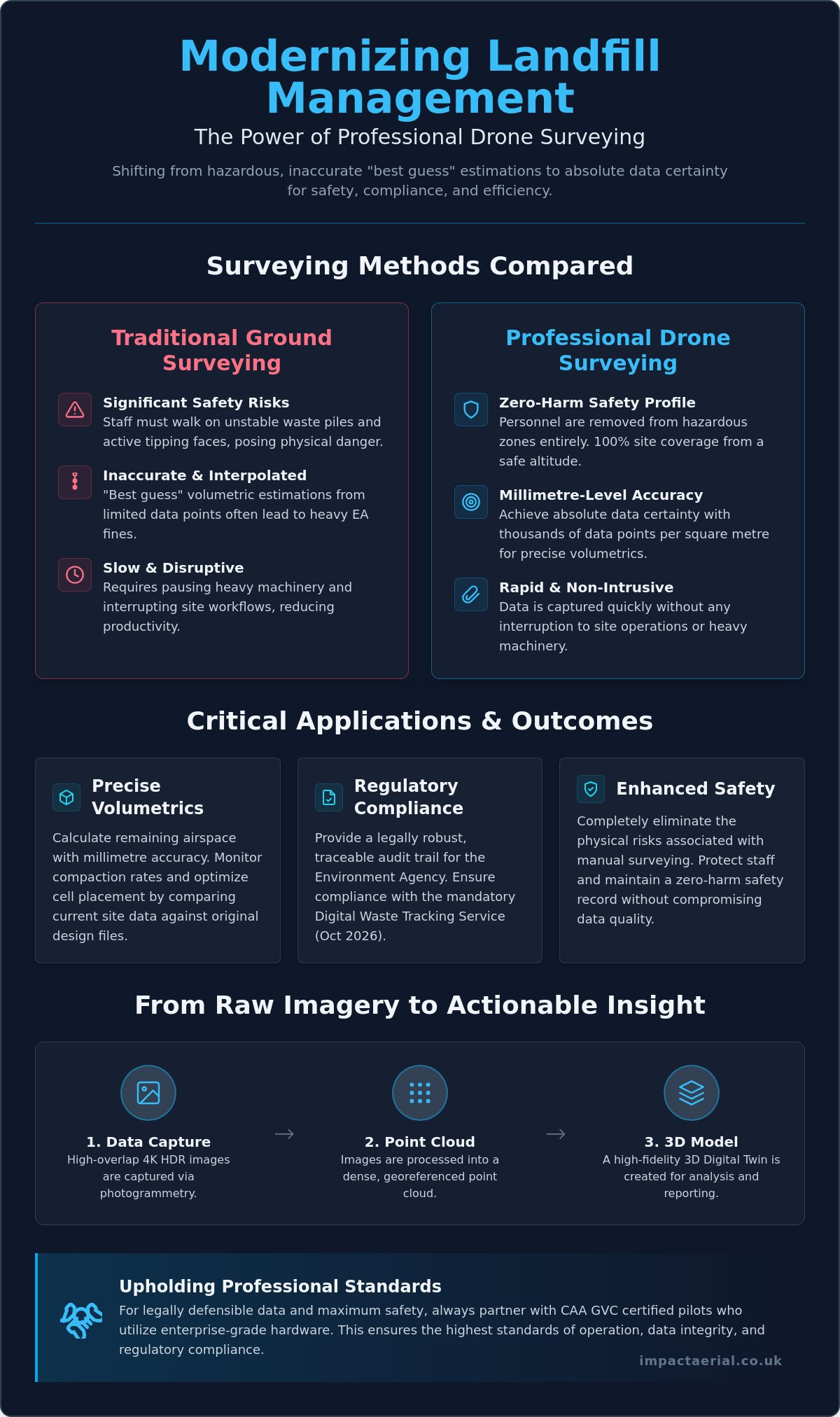
How much is a single centimetre of error worth when the Environment Agency is auditing your remaining airspace? For many UK landfill operators, traditional ground surveying isn’t just a slow process. It’s a significant safety liability that frequently results in “best guess” volumetric estimations. Walking on unstable waste piles to gather data puts staff at risk and often leads to the inaccurate reporting that triggers heavy EA fines. Integrating a professional drone survey for landfill sites changes this dynamic by shifting from interpolated estimation to absolute data certainty.

You’ll discover how millimetre-accurate volumetric data and high-resolution 3D site models provide a legally robust audit trail for your operations. We’ll outline how professional aerial surveys ensure compliance with the October 2026 mandatory Digital Waste Tracking Service while maintaining a zero-harm safety profile. From precise airspace calculations to reduced surveying costs, this guide explains how meticulous aerial data helps you navigate the increasingly strict regulatory environment with confidence and technical precision.

Key Takeaways

  • Eliminate the significant safety risks of manual ground surveying by transitioning to high-altitude aerial data capture for 100% site coverage.
  • Achieve millimetre-accurate volumetric reports that allow for precise remaining airspace calculations and compaction monitoring against original design files.
  • Ensure full regulatory compliance by utilizing a professional drone survey for landfill sites to provide the traceable topographical evidence required by the Environment Agency.
  • Gain superior data density with thousands of points per square metre, enabling the creation of high-resolution 3D models that far exceed traditional GPS capabilities.
  • Understand the operational necessity of hiring CAA GVC certified pilots who utilize enterprise-grade hardware to maintain the highest safety and data standards.

Why Drone Surveys are Essential for Modern Landfill Management

Modern landfill management requires a level of precision that manual methods simply cannot provide. UAV landfill surveying involves high-altitude data capture using specialized aircraft to perform topographical mapping and volumetric analysis. This shift from “walking the lines” with handheld GPS units to 100% aerial coverage allows for millimetre-level precision across the entire subject site. Beyond simple mapping, these surveys support critical environmental licensing requirements and are vital for the eventual surrender of licenses for closed sites. Precise data ensures that landfill gas monitoring and leachate management systems are accurately positioned and monitored according to strict environmental standards. The result is a zero-harm safety profile and a rapid data turnaround that provides site managers with actionable insights in a fraction of the time required by traditional methods. Operators no longer need to rely on “interpolated estimations” that can lead to regulatory friction; instead, they gain absolute data certainty.

To better understand how this technology is applied in real-world scenarios, watch this helpful video:

The Safety Advantage: Eliminating On-Site Hazards

Safety is the cornerstone of any industrial operation. Traditional surveying requires staff to traverse active tipping faces and unstable terrain, exposing them to significant physical risks. By using a drone survey for landfill sites, you remove personnel from these hazardous zones entirely. This transition eliminates the risk of vehicle-pedestrian interfaces during peak operational hours. Data is captured from a safe altitude, allowing site work to continue without the need to pause heavy machinery or interrupt complex workflows. This non-intrusive approach ensures that your site remains productive while maintaining the highest possible safety standards for all on-site personnel. It provides psychological comfort to management, knowing that accurate data doesn’t come at the cost of staff welfare.

From Raw Imagery to Actionable 3D Models

The technical process begins with photogrammetry. Here, 4K HDR images are captured with high overlap and processed into georeferenced point clouds. These point clouds form the basis of a Digital Elevation Model (DEM), which provides a clear visualization of the site’s topography. This technical output allows operators to see every contour and slope with absolute clarity, identifying potential drainage issues or slope instabilities before they become critical. In this context, a Digital Twin is a high-fidelity, georeferenced 3D digital replica of the landfill site that allows for real-time analysis and historical comparison of waste levels and site evolution. By comparing these models over time, you create a meticulous record of site changes that is invaluable for long-term planning and compliance auditing.

Critical Applications: Volumetrics, Airspace, and Compaction

Calculating remaining airspace is no longer a matter of interpolation or guesswork. A professional drone survey for landfill sites provides absolute data certainty by generating high-resolution 3D overlays that compare current site conditions against the original Top of Waste (TOW) design files. This process allows operators to identify overfill hotspots long before they lead to regulatory friction or the need for expensive remediation. By capturing millions of data points across the entire site surface, aerial surveys ensure that every cubic metre of licensed void space is accounted for with millimetre-level precision.

Maximizing Airspace Efficiency

Efficiency in waste management depends on knowing exactly how materials are settling. By using advanced cross-section analysis, site managers can track how waste compresses under the final cap. This Z-axis data is critical for refining cell placement strategies and optimizing the use of available space. As highlighted in the technical review on Applying Drone Technology to Landfills, integrating CAD design files with drone-captured 3D meshes allows for a level of precision planning that traditional ground surveys cannot match. You can visualize the current state of a cell versus its final design profile in a digital environment, allowing for proactive adjustments to daily tipping operations.

Compaction and Settlement Monitoring

Monitoring compaction rates is essential for ensuring the maximum utilization of your licensed void space. By comparing sequential surveys over time, drones generate detailed heat maps that visualize elevation changes across the site. These maps are invaluable for identifying “soft spots” or uneven settlement in closed cells that might otherwise go unnoticed. Unlike standard software-only solutions, a meticulous approach to data collection enables “Z-axis” cross-section analysis. This provides a clear view of how materials are compressing over weeks or months, ensuring the density of the waste meets engineering requirements. Identifying these trends early helps maintain site integrity and prevents the structural issues often associated with uneven settlement.

Effective management also extends to the logistics of cover soil and daily cell materials. Drones provide accurate volumes for these stockpiles in minutes, ensuring that you never run short of essential materials for site maintenance. This technical approach to aerial data collection ensures that every operational decision is backed by a precise, georeferenced audit trail. It’s a methodical process that turns raw imagery into a powerful management tool for modern waste facilities.

Drone Survey for Landfill Sites: Precision Waste Management & Compliance

Environmental Monitoring and UK Regulatory Compliance

Meeting Environment Agency (EA) requirements for topographical evidence is a fundamental part of modern waste management. The EA demands precise, verifiable data to monitor site status and ensure that operations remain within their permitted boundaries. A professional drone survey for landfill sites provides this evidence with a level of detail that ground-based teams cannot match. It creates a definitive georeferenced record that satisfies regulatory audits and provides a transparent history of site activity. For local authorities managing un-licensed closed landfill sites, aerial surveys are invaluable for delineating waste boundaries where historical records may be incomplete or inaccurate.

When commissioning a drone survey for landfill sites, the technical credentials of the flight team are paramount. It is essential to hire CAA GVC certified pilots who understand the complexities of industrial airspace. This certification isn’t just a badge; it’s a legal requirement for complex commercial operations that ensures the pilot has the competency to manage risks on high-hazard sites. Operating without these credentials or the appropriate insurance can lead to significant legal liabilities for the site operator.

Advanced sensor technology has expanded the scope of environmental monitoring beyond simple photography. Thermal and multispectral sensors can now detect early signs of leachate leaks or sub-surface gas migration by identifying thermal anomalies or vegetation stress. This proactive approach is backed by global standards, such as the guidance from the EPA on detecting landfill emissions with drones, which highlights how aerial platforms provide a safer and more comprehensive view of methane plumes than traditional ground-level “sniffing” methods.

LiDAR vs. Photogrammetry for Closed Sites

Choosing the right sensor depends on the lifecycle stage of the landfill cell. While photogrammetry is excellent for active tipping faces, LiDAR (Light Detection and Ranging) is essential for older, closed sites. LiDAR pulses can penetrate heavy vegetation and scrub, allowing us to create accurate terrain models of the ground surface beneath the canopy. This is critical for monitoring settlement or identifying drainage issues on sites that have been reclaimed by nature and are no longer easily accessible on foot.

Audit-Ready Data for License Surrender

Surrendering an environmental license is a meticulous process that requires proof of site stability. We provide 100% coverage surveys that serve as definitive topographical evidence for the EA during the surrender application. Maintaining a digital archive of these surveys offers long-term liability protection, proving the state of the site at the point of handover. To ensure total client security, professional operators maintain £5m commercial liability insurance, providing the necessary reassurance when working in high-risk waste environments.

Comparing Drone Surveys to Traditional Ground-Based Methods

The technical superiority of aerial data collection becomes most apparent when comparing data density. Traditional ground surveys rely on a surveyor manually capturing a few hundred GPS points across a site. This method results in an “interpolated” model, where software must estimate the terrain between those sparse data points. In contrast, a professional drone survey for landfill sites captures thousands of points per square metre. This creates an “absolute” model that reflects the true topography of the waste mass without the guesswork associated with manual sampling. This level of detail is essential for high-stakes decisions regarding remaining capacity and regulatory reporting.

Operational speed is another critical differentiator. Surveying a 50-acre landfill site on foot can take between two and three days of intensive field work. A specialized UAV can capture the same area in approximately 30 minutes. This massive reduction in man-hours doesn’t just lower costs; it makes frequent monitoring financially viable. Instead of annual or quarterly snapshots, operators can perform monthly or even weekly capacity checks to maintain a tighter grip on their compaction rates and tipping schedules. This efficiency allows for a more responsive management style that adapts to the daily realities of waste intake.

Accuracy and Precision Standards

Achieving survey-grade accuracy requires more than just a high-resolution camera. We utilize RTK (Real-Time Kinematic) drones and strategically placed Ground Control Points (GCPs) to ensure that every pixel is georeferenced with absolute precision. While ground teams struggle with the “interpolated” gaps in their data, our aerial approach provides a continuous 3D mesh. A continuous data blanket ensures that 100% coverage eliminates the risk of missing topographic anomalies that often fall between the gaps of sparse manual survey points. This precision is vital when calculating the financial value of remaining void space or preparing for an Environment Agency audit.

Operational Continuity

One of the most significant advantages of aerial surveying is the lack of site downtime. Ground teams often require heavy machinery to stop or move to different cells to ensure their safety, which disrupts the tipping workflow. Drones operate in the airspace above the site, allowing for zero-harm data collection while your plant remains fully operational. Furthermore, the ability to utilize thermal or LiDAR sensors means surveys can often proceed in varied weather conditions or lighting that would hinder traditional optical methods. This reliability ensures that your data collection schedule remains on track, regardless of the operational challenges on the ground.

If you’re ready to transition from manual estimations to absolute data certainty, our team provides comprehensive drone commercial property surveys and industrial mapping across the UK. We handle the technical complexity so you can focus on efficient site management.

Partnering with Impact Aerial for Professional Landfill Surveys

Partnering with Impact Aerial provides a methodical transition from raw data to actionable site intelligence. We specialize in commercial drone surveys tailored specifically for the rigours of industrial waste environments. Our approach centers on utilizing high-specification DJI Enterprise hardware, which ensures the highest possible data integrity for your volumetric and compliance reporting. Beyond the flight itself, our comprehensive post-production services transform millions of georeferenced points into usable CAD and BIM formats. This allows your engineering teams to integrate aerial models directly into existing site management workflows without technical friction.

Safety is our primary operational pillar. Every mission begins with exhaustive risk assessments and CAA-approved flight planning to ensure total compliance with national aviation standards. We understand that landfill sites are high-risk environments with complex machinery and shifting terrains. Our protocols are designed to maintain a zero-harm safety profile while delivering the technical precision required by modern environmental regulations. It’s about providing the reassurance that your surveying needs are met by a compliant, professional operator.

Our Technical Capabilities

We deploy specialized 4K HDR and thermal-equipped enterprise drones to capture multi-layered data sets in a single flight. While we have deep experience working within the West Midlands, our team operates nationwide to support major waste operators across the UK. This geographical reach is balanced with a meticulous focus on data compatibility; we ensure our outputs integrate seamlessly with your site management software and long-term design platforms. Whether you’re monitoring an active cell or managing a closed site, our multi-sensor payloads provide the clarity needed for effective oversight.

Get a Professional Landfill Assessment

Starting a drone survey for landfill sites begins with a structured consultation to scope your specific data requirements. We perform a site feasibility study to identify the optimal flight paths and sensor choices for your terrain. Our pricing remains transparent, and we prioritize rapid report delivery to help you meet time-sensitive compliance deadlines or EA audit windows. This structured approach provides the psychological comfort of knowing your data is handled by vetted specialists who value industry standards as much as you do. We don’t just deliver images; we deliver the technical certainty required to manage your site’s future.

Contact Impact Aerial today for a bespoke drone survey quote.

Future-Proofing Your Waste Management Strategy

Transitioning to aerial data collection is no longer a luxury for UK landfill operators; it’s a regulatory and operational necessity. By replacing manual surveys with a professional drone survey for landfill sites, you eliminate the safety risks associated with unstable terrain while gaining millimetre-accurate volumetric data. This precision ensures that your remaining airspace calculations and compaction monitoring are based on absolute data certainty rather than interpolated guesswork. As the Environment Agency increases its focus on digital waste tracking, having a georeferenced audit trail becomes your strongest asset for long-term compliance and successful license surrender.

We provide the technical expertise and regulatory reassurance your facility requires. Our team of CAA GVC Certified Pilots operates with £5m Commercial Liability Insurance and utilizes expert DJI Enterprise Hardware to deliver high-tier results. Request a Professional Landfill Survey Quote today to secure a bespoke assessment for your site. Take control of your site’s data and safety profile with a solution built for the demands of modern waste management.

Frequently Asked Questions

How accurate are drone surveys for calculating landfill volume?

Drone surveys achieve millimetre-level precision, typically within 2-5cm vertical accuracy when using RTK or PPK-corrected datasets. This level of detail is essential for calculating remaining void space and monitoring compaction rates against original TOW design files. By capturing thousands of points per square metre, drones provide a far more reliable volumetric report than traditional ground-based sampling.

Does the drone interfere with active landfill machinery or GPS systems?

Drones don’t interfere with active landfill machinery or on-site GPS systems because they operate on distinct, regulated frequency bands. Modern enterprise drones use encrypted transmission protocols to ensure signal integrity in industrial environments. Since the survey takes place in the airspace above the site, operations can continue without interruption, maintaining total operational continuity and safety for ground personnel.

What UK regulations apply to flying drones on a landfill site?

Commercial drone operations on landfill sites must comply with CAA regulations, specifically requiring pilots to hold a General Visual Line of Sight Certificate (GVC). Operators must also adhere to Remote ID mandates starting January 1, 2026, for class-marked drones. These strict standards ensure that every flight is conducted within a legal framework that prioritizes site safety and data accountability.

Can drones detect landfill gas or leachate leaks?

Drones equipped with specialized thermal and multispectral sensors can identify the thermal signatures of leachate leaks and gas migration. While standard RGB cameras capture topographical data, these advanced sensors detect vegetation stress or temperature anomalies that indicate sub-surface issues. This proactive monitoring allows site managers to address environmental risks before they escalate into regulatory breaches or Environment Agency fines.

How often should a landfill site be surveyed by a drone?

The ideal frequency for a drone survey for landfill sites depends on waste intake volumes, but many operators opt for monthly or quarterly assessments. Frequent surveys allow for tighter control over compaction rates and more accurate monthly reporting to the Environment Agency. Regular data capture ensures that any overfill hotspots are identified early, preventing expensive remediation work at the end of the cell’s life.

What file formats are provided after a drone landfill survey?

Data’s typically delivered in industry-standard formats including .DXF and .DWG for CAD integration, and .OBJ or .PLY for 3D meshes. We also provide GeoTIFFs for orthomosaic mapping and .LAS or .LAZ files for detailed point clouds. These formats ensure that the aerial data integrates seamlessly with your existing Building Information Modelling (BIM) and site management software.

How long does it take to get the volumetric report after the flight?

Most volumetric reports are processed and delivered within 48 to 72 hours following the flight mission. While the data capture itself takes less than an hour for a typical 50-acre site, the post-production phase involves rigorous photogrammetric processing to ensure survey-grade accuracy. This rapid turnaround allows site managers to make data-driven decisions while the site conditions are still current and relevant to operations.

Is a drone survey cheaper than a traditional land survey?

Drone surveys are significantly more cost-effective than traditional land surveys due to the drastic reduction in field hours and personnel risk. A 50-acre site that would take days to survey on foot is completed in minutes from the air. This efficiency reduces the total man-hours required for data collection and processing, making high-frequency monitoring a financially viable option for modern waste facilities.

Virtual Tour for Gyms and Fitness Centres: The 2026 Marketing Guide

Did you know that visitor engagement with a 360 virtual tour is 300% higher than with traditional photos or videos? In a market projected to reach $142 billion by the end of 2026, standing out requires more than just a gallery of static equipment shots. Many potential members hesitate to join because they feel intimidated by unfamiliar environments or crowded spaces. Implementing a high-quality virtual tour for gyms and fitness centres solves this by providing a transparent, floor-level view of your facility before a prospect even packs their gym bag.

It’s frustrating to watch high bounce rates on your membership pages when you know your facility is top-tier. You likely want a way to capture the energy of your group classes and the precision of your layout without relying on flat imagery. This 2026 marketing guide will show you how professional FPV drone fly-throughs and immersive tours remove the “gym intimidation” barrier and drive membership sales. We’ll cover everything from safety-conscious indoor filming techniques to the latest data on maximizing your digital return on investment through “wow-factor” social content and transparent facility previews.

Key Takeaways

  • Lower the psychological barrier for prospective members by providing a transparent, 24/7 digital open house that builds trust before they even step foot in your facility.
  • Contrast the interactive detail of 360-degree tours with the cinematic energy of FPV drone fly-throughs to determine which technology best showcases your specific gym environment.
  • Ensure operational safety and regulatory compliance by understanding the importance of using CAA-certified pilots for complex indoor filming projects within commercial spaces.
  • Drive measurable business growth by integrating a virtual tour for gyms and fitness centres to improve SEO dwell time and significantly increase membership sign-up rates.
  • Leverage commercial-grade DJI Enterprise hardware and expert post-production to deliver 4K HDR visual quality that reflects the premium standards of your fitness brand.

Overcoming “Gym Intimidation” with Immersive Virtual Tours

A virtual tour for gyms and fitness centres serves as a 24/7 digital open house, offering a transparent view of the facility that static image galleries cannot replicate. By 2026, the fitness industry has shifted away from curated, staged photography toward high-fidelity, interactive experiences. This shift is driven by a consumer demand for authenticity and a need to address the psychological barriers that prevent many individuals from ever stepping through the front door. To understand the technical foundation of these tools, it is helpful to look at the broader context of What is a Virtual Tour? and how it functions as a foundational marketing asset.

To see a practical example of how these digital environments operate for a fitness facility, watch this helpful video:

Transparency is the primary currency of trust in the modern fitness market. Prospective members often feel a sense of “gym intimidation,” a psychological barrier caused by the fear of the unknown. They worry about the layout, the condition of the equipment, and the privacy of the changing areas. A professional virtual tour for gyms and fitness centres removes these anxieties by allowing a self-paced, private exploration of the entire space. It provides a visual guarantee that the facility meets their standards for cleanliness, equipment variety, and social atmosphere.

The Psychology of the Digital Walkthrough

First-time gym-goers often experience anxiety regarding where to go and how to use the space. A digital walkthrough allows them to familiarise themselves with the reception area, the locker rooms, and the specific location of various machines. This familiarity reduces the fear of the unknown significantly. By showcasing the vibe and community atmosphere through cinematic movement, you provide psychological comfort. Users can explore recovery zones or high-end equipment areas at their own speed, building a mental map of their future workout routine before they arrive.

Why 2026 Members Expect Transparency

The “try before you buy” expectation has expanded from digital products into physical services. Modern consumers use virtual tours as a tool for inclusivity and accessibility planning. They need to see if the aisles are wide enough for a wheelchair or if the lighting in the yoga studio matches their preferences. Hiding nothing from prospective members builds immediate brand authority. When a facility is willing to show every corner, from the weight room to the showers, it signals a commitment to quality and professional standards that competitors using static photos simply cannot match.

FPV Drone Fly-Throughs vs. 360 Virtual Tours: A Comparison

Choosing the right visual medium depends on your specific marketing objectives and the physical layout of your facility. A professional virtual tour for gyms and fitness centres typically falls into two distinct categories: high-energy cinematic flow or high-detail interactive exploration. While both formats provide an immersive experience, they serve different psychological purposes for the prospective member. Understanding the technical distinction between the point-and-click nature of 360 tours and the one-shot flow of FPV drones is essential for a high-performing 2026 marketing strategy.

The hardware requirements for these services are equally specialized. Professional pilots utilize commercial-grade DJI Enterprise hardware to ensure 4K HDR clarity and stable flight paths during indoor operations. In contrast, interactive tours rely on high-resolution 360-degree cameras that stitch together multiple photospheres to create a navigable 3D model. These tools are proven to boost engagement and conversion rates by providing the transparency that modern consumers demand before committing to a membership.

Cinematic FPV Drone Fly-Throughs

FPV, or First Person View, drones create a sense of momentum that static imagery cannot replicate. The pilot operates the craft using immersive goggles, allowing for precise movement through narrow spaces like squat racks or between cardio machines. This creates a “thrill” factor that is highly effective for capturing the scale of large leisure centres and multi-floor gyms in a single, continuous shot. Beyond the website experience, these flights provide high-impact content for social media, as short, energetic clips can be extracted from the main footage to drive engagement on visual platforms.

Interactive 360-Degree Matterport Tours

While drones capture energy, 360-degree tours provide utility and detail. This technology allows a user to virtually “step inside” specific areas such as saunas, treatment rooms, or spin studios to inspect the facilities at their own pace. By using a virtual tour for gyms and fitness centres built on platforms like Matterport, you can integrate “Mattertags.” These are interactive hotspots that highlight premium equipment brands, class schedules, or specific membership benefits. These tours also integrate seamlessly with Google Street View, which significantly improves local search visibility and builds immediate trust through technical transparency.

For the most comprehensive results, many leading brands are now adopting “Hybrid Tours.” This approach combines the cinematic “wow-factor” of an FPV fly-through for social engagement with the practical, self-guided navigation of a 360 tour for final membership conversions. Implementing these advanced drone services ensures your facility is represented with the technical precision and safety standards expected in a professional commercial environment.

Virtual Tour for Gyms and Fitness Centres: The 2026 Marketing Guide

Ensuring Safety and Compliance for Indoor Drone Filming

Safety is the primary concern for any operator managing a high-traffic environment. When commissioning a virtual tour for gyms and fitness centres, the most common question involves the physical risk of indoor flight. Flying a drone in a confined space requires a level of precision that standard consumer equipment cannot provide. Professional operations rely on meticulous risk assessments and hardware equipped with 360-degree prop guards to ensure the safety of both the facility and its assets. Every flight path is pre-mapped to avoid equipment, lighting fixtures, and architectural obstacles.

Financial protection is another pillar of professional compliance. A reputable aerial filming company should hold at least £5m in commercial liability insurance specifically tailored for drone operations in fitness venues. This coverage provides psychological comfort and tangible security for gym owners. It ensures that in the unlikely event of a technical failure, the business is fully protected against property damage or operational downtime. Without this specific insurance, the gym owner could be held personally liable for any incidents occurring during the shoot.

The Role of CAA GVC Certification

Hiring a pilot without the proper credentials is a significant liability risk for your business. A CAA GVC certified pilot has undergone rigorous training and assessment to operate in complex environments. While survey drones are typically associated with outdoor technical inspections, the same principles of flight safety and data-centric precision apply to indoor gym tours. Verifying these credentials before signing a contract is a non-negotiable step for any compliant business. It guarantees that the pilot understands the latest regulatory transitions and safety protocols required for commercial work.

Disruption-Free Filming Strategies

Operational continuity is vital for a busy fitness facility. Most professional shoots are scheduled during off-peak hours or dedicated member-free windows to avoid any interaction with the public. We implement a “clean site” protocol to ensure the facility looks its best under 4K HDR lenses; this involves hiding loose cables, resetting equipment, and ensuring consistent lighting. Managing member privacy and GDPR compliance is also a priority. We ensure no identifiable personal data or faces are captured during the flight, maintaining the integrity of your brand and the privacy of your community. This structured, methodical approach guarantees a high-end output with zero impact on your members’ workout experience.

Maximising ROI: SEO and Conversion Benefits

Implementing a virtual tour for gyms and fitness centres is a strategic investment that generates measurable returns across multiple digital channels. From a technical SEO perspective, interactive 3D environments significantly increase “dwell time,” which is the duration a visitor spends engaging with your website. Google’s algorithms interpret high dwell time as a strong signal of content relevance and quality, which can lead to improved organic search rankings. When users stay on your site to explore the weight room or the yoga studio, they are providing the data-centric proof of engagement that search engines reward.

The impact on membership sales is equally quantifiable. Data from oVRworldwide indicates that online inquiries for memberships and services can increase by 200% when a virtual tour is present. This conversion lift occurs because the tour provides the psychological comfort discussed in earlier sections, moving a prospect from curiosity to a confirmed sign-up. Additionally, modern virtual tour platforms provide backend analytics that allow gym owners to see which areas of their facility are most popular. If the majority of users are zooming into the recovery zone or the functional fitness area, you can adjust your marketing focus to highlight those specific assets.

Local SEO and Google Business Profile

High-quality 360 imagery is a primary driver for appearing in the “Local Map Pack,” the group of three business listings that appear at the top of Google search results. There is a clear synergy between professional drone photography and local search authority. By uploading immersive tours directly to your Google Business Profile, you encourage users to click the “See Inside” button. This interaction not only improves your local ranking but also builds immediate trust by showing the live reality of your facility directly on the search engine results page.

Content Repurposing for Social Media

A single professional filming session provides a deep library of marketing assets. A two-minute FPV drone fly-through can be edited into ten or more 15-second TikTok and Instagram Reels, each focusing on a different aspect of the gym. These energetic, short-form clips provide the “wow factor” that drives social shares and viral engagement. Beyond video, high-resolution stills extracted from the 4K HDR footage are perfect for print marketing, internal signage, and member onboarding emails. This methodical approach to content ensures that every frame of the original flight is used to maximise your brand’s digital presence.

To begin planning your facility’s digital transformation, contact our specialist team to discuss a tailored virtual tour solution that aligns with your 2026 growth targets.

Partnering with Impact Aerial for Professional Gym Tours

Impact Aerial operates as a technical specialist in high-end drone services, delivering precision-engineered visual content specifically for the fitness sector. We utilize commercial-grade DJI Enterprise hardware to ensure every virtual tour for gyms and fitness centres meets the highest standards of 4K HDR clarity. This hardware selection is a deliberate choice; these systems provide the stability and low-light performance necessary to capture professional-tier footage in complex indoor environments. Our methodical approach ensures that the final output reflects the premium nature of your facility and brand, providing the reassurance that modern consumers require.

Our end-to-end process is built on a foundation of safety and technical excellence. We guide clients through a structured journey that begins with a comprehensive safety consultation and site survey, moving through to precision filming and expert post-production editing. While our roots are firmly in the West Midlands, our operational capacity extends UK-wide. This makes us a reliable partner for both boutique independent studios and national fitness chains that require consistent, high-quality visual assets across multiple locations. We handle the logistical complexities of multi-site shoots, ensuring a unified brand voice across your entire digital portfolio.

Our Technical Edge in Fitness Marketing

We employ proprietary indoor flight techniques to deliver smooth, cinematic fly-throughs that navigate narrow equipment aisles and multi-floor layouts with ease. Our post-production services are equally specialized, ensuring that the final edit matches your gym’s specific branding, color palette, and community energy. We maintain a rigorous commitment to operational safety, backed by £5m commercial liability coverage for every project we undertake. This meticulous attention to detail ensures that your marketing assets are produced without compromising the security of your facility or its members, giving you total peace of mind during the filming process.

Next Steps: Booking Your Gym Survey

The first step in the process is a structured initial consultation where we define your specific marketing goals and identify the unique facility highlights you wish to showcase. Whether your focus is on a new recovery suite, a high-tech spin studio, or a spacious functional training zone, we tailor the flight plan to meet those objectives. We offer bespoke quotes for single-site projects as well as enterprise-level packages for multi-location fitness brands seeking a unified digital presence. This collaborative approach ensures that the technical output aligns with your business’s data-centric goals for membership growth.

Contact Impact Aerial today for a professional virtual tour consultation to discover how our technical expertise can transform your gym’s online conversion rates and digital authority.

Future-Proofing Your Fitness Marketing Strategy

The integration of immersive technology is no longer a luxury; it’s a standard for high-performing fitness brands. By providing a transparent view of your facilities, you effectively dismantle the psychological barriers of gym intimidation while simultaneously boosting your local search authority. Whether you choose the cinematic energy of an FPV fly-through or the interactive utility of a 360-degree walkthrough, a professional virtual tour for gyms and fitness centres acts as a powerful conversion tool that works 24/7. Success in 2026 requires this blend of visual excellence and technical transparency to meet the rising expectations of modern members.

Impact Aerial provides the technical expertise and regulatory compliance necessary to execute these projects safely within commercial environments. Our team of CAA GVC Certified Pilots utilizes specialized hardware to deliver 4K HDR Cinematic Output, all while maintaining £5m Commercial Liability Insurance for your protection. We ensure a meticulous, disruption-free process that prioritizes your facility’s operational continuity and brand integrity. It’s time to provide your prospects with the psychological comfort they need to commit to their fitness journey.

Book Your Professional Gym Virtual Tour Consultation

Frequently Asked Questions

Do I need to close my gym during the virtual tour filming?

You don’t necessarily need to close your facility, but we strongly recommend filming during off-peak hours or dedicated member-free windows. This ensures a “clean site” protocol where equipment is perfectly staged and member privacy is maintained. For a high-quality virtual tour for gyms and fitness centres, capturing the space without crowds allows for better 4K HDR clarity and a more professional finish that highlights your facility’s premium assets.

How long does it take to create a full 3D tour and drone fly-through?

The onsite capture of a standard facility usually takes between four and eight hours, depending on the square footage and complexity. Following the shoot, our post-production team requires approximately five to ten working days to stitch 360-degree imagery and edit cinematic FPV footage. This structured timeline ensures that every frame is polished, branded, and optimized for high-speed web delivery and mobile compatibility.

Will the drone be loud enough to disturb members in other rooms?

Modern FPV drones used for indoor filming, often called “cinewhoops,” are significantly quieter than larger outdoor models. While there is a distinct hum during flight, it’s rarely loud enough to disturb members in separate studios or changing areas. We meticulously plan flight paths to minimize any auditory impact, ensuring that your gym’s daily operations continue smoothly while we capture high-energy, cinematic perspectives of your workout zones.

What is the difference between a standard 360 tour and an FPV drone tour?

A standard 360 tour offers a user-controlled, point-and-click experience where prospects can explore specific rooms at their own pace. In contrast, an FPV drone tour provides a continuous, cinematic “one-shot” fly-through that captures the energy and layout of the entire facility in motion. Combining both technologies creates a comprehensive marketing asset that offers both the utility of detailed inspection and the “wow factor” of high-speed aerial movement.

Can I use the virtual tour on my social media pages like Instagram and TikTok?

Yes, the content is highly repurposable for platforms like Instagram and TikTok. Short, high-impact clips from an FPV fly-through are particularly effective as Reels or TikTok videos, driving significantly higher engagement than static photos. We provide the edited files in formats optimized for vertical viewing, allowing you to integrate these visual assets into your social media strategy and member onboarding emails immediately after production.

Is indoor drone filming legal in the UK in 2026?

Indoor drone filming remains legal in the UK in 2026 because aviation regulations typically apply only to flights conducted in open airspace. However, commercial operations must still adhere to strict safety protocols and health and safety legislation. We maintain £5m commercial liability insurance and utilize CAA GVC certified pilots to ensure every indoor flight is conducted with the highest level of professional compliance and risk mitigation.

How much does a professional virtual tour for a gym typically cost?

The cost of a professional virtual tour for gyms and fitness centres varies based on several technical factors. These include the total square footage of the facility, the number of locations requiring surveys, and whether you opt for a hybrid package combining 360-degree tours with FPV drone fly-throughs. We provide bespoke quotes after an initial consultation to ensure the service matches your specific marketing goals and facility requirements accurately.

Do virtual tours work on mobile devices and VR headsets?

Every tour we create is fully responsive and optimized for mobile devices, tablets, and desktop computers. Our 360-degree tours are also compatible with modern VR headsets, providing an even more immersive “try before you buy” experience for prospective members. This cross-platform accessibility ensures that your digital open house reaches potential clients regardless of the hardware they use to research your fitness facility online.

What Equipment is Used for Drone Surveys? A Professional UK Guide

Can a standard consumer drone deliver the centimetre-level accuracy required for a major UK infrastructure project, or is it merely an expensive toy risking a significant construction error? You aren’t alone if you feel confused about the technical divide between retail gadgets and enterprise-grade systems. Understanding exactly what equipment is used for drone surveys is the first step toward mitigating risk and ensuring your data meets professional industry standards.

We understand that navigating the 2026 UK drone regulations, including new UK class marks and Remote ID requirements, adds another layer of complexity to your decision-making process. This guide provides a definitive checklist of the hardware, sensors, and software required to produce high-tier aerial data. You’ll learn the critical differences between standard GPS and RTK technology, the role of specialized sensors like LiDAR, and the processing software that turns raw imagery into BIM-ready assets. By the end, you will have the technical insight needed to select a certified drone service provider that prioritizes precision, compliance, and operational safety.

Key Takeaways

  • Learn how to select the optimal UAV platform, comparing the agility of multirotors with the endurance of fixed-wing drones for large-scale site coverage.
  • Understand why specialized sensors with global shutters and high resolution are essential for technical surveys, far exceeding the capabilities of standard 4K cameras.
  • Discover what equipment is used for drone surveys to achieve centimetre-level accuracy, including the critical role of RTK and GNSS hardware in correcting satellite data.
  • Gain insights into the high-performance computing hardware and photogrammetry software required to process thousands of aerial images into actionable, BIM-ready data.
  • Identify the mandatory safety and regulatory equipment required by the CAA to ensure your operations remain compliant and risk-mitigated on professional work sites.

Selecting the Right UAV Platform: Multirotor vs. Fixed-Wing

The term “platform” in the context of professional aerial work refers to the aircraft itself. It acts as the primary carrier for the sophisticated sensors required to generate accurate maps and models. When evaluating what equipment is used for drone surveys, the platform choice is the most fundamental decision an operator makes. A survey drone is defined as a high-precision UAV designed specifically for repeatable data collection. This ensures that every flight produces consistent results, allowing for precise temporal comparisons across different stages of a construction or environmental project.

Professional operators across the UK typically rely on DJI Enterprise drones because of their proven reliability and modular payload options. The choice of airframe depends heavily on the specific geography of the site, the required flight duration, and the total weight of the sensors being deployed. Payload weight isn’t just about the camera; it includes batteries, transmission systems, and mandatory safety hardware. This selection process is a core component of a professional unmanned aerial photogrammetric survey, where the stability of the platform directly influences the quality of the final data set.

To better understand how these platforms integrate into a professional workflow, watch this helpful video:

Multi-rotor Drones for Precision and Vertical Inspection

Multi-rotor aircraft are the workhorses of the UK drone industry. Their ability to hover with absolute stability makes them ideal for drone roof surveys and detailed inspections of confined spaces. Because they utilize Vertical Take-Off and Landing (VTOL) technology, they’re perfect for cramped UK construction sites where space is at a premium. The high-detail imagery captured during a hover allows engineers to identify specific structural defects that a moving aircraft might miss. Most UK firms utilize quadcopters like the Mavic 3 Enterprise for its portability or the Matrice 350 RTK for its ability to carry multiple heavy sensors simultaneously.

Fixed-Wing Drones for Large-Scale Land Mapping

While multi-rotors excel at detail, fixed-wing drones are built for endurance. These platforms can cover hundreds of hectares in a single flight, making them the preferred choice for large-scale uav land surveying and topographic mapping. Unlike their multi-rotor counterparts, they require more significant space for take-off and landing. Some models use a belly-land approach, while others have evolved to include VTOL rotors for vertical lift-off followed by horizontal flight. For massive infrastructure projects or expansive agricultural mapping, their efficiency and high cruise speeds are unmatched by traditional quadcopters.

Specialised Sensors: The “Eyes” of the Drone Survey

While the aircraft provides the means of transport, the sensors are the true workhorses of any aerial operation. They determine the resolution, accuracy, and technical utility of the collected data. Professional operators don’t rely on consumer-grade hardware; they use enterprise systems where payloads are often interchangeable to meet specific project requirements. When considering what equipment is used for drone surveys, the payload is often more important than the aircraft itself because it defines the quality of the final deliverable.

Sensor choice is dictated entirely by the specific output required, whether that’s a high-density 3D model, a topographic map, or a detailed heat map. These specialised tools allow us to capture data that exceeds the limitations of human vision and standard photography. If you’re unsure which technology fits your requirements, our experts can help you select the right aerial technology for your specific site needs.

High-Resolution RGB and Photogrammetry Sensors

Technical surveys require more than just a 4K video feed. High-resolution RGB sensors, typically featuring 1-inch CMOS sensors or larger, are the standard for professional photogrammetry. A critical distinction in identifying what equipment is used for drone surveys is the presence of a mechanical or global shutter. In consumer drones, “rolling shutters” capture images line-by-line, which causes significant geometric distortion when the drone moves at high speeds. Mechanical shutters eliminate this “jello effect,” ensuring every pixel is captured simultaneously. This precision is vital for creating high-density point clouds and accurate orthomosaics that engineers can trust for measurements.

Thermal Imaging and Multispectral Cameras

Beyond the visible spectrum, specialised sensors provide insights invisible to the naked eye. Radiometric thermal sensors are the primary tool for PV solar farm thermal surveys, where they detect minute temperature variances that indicate failing cells or electrical faults. These sensors don’t just “see” heat; they assign a specific temperature value to every pixel in the image. Similarly, multispectral sensors measure light reflection across several bands to assess plant health or environmental changes. Whether you’re identifying heat loss in a building envelope or monitoring crop stress, the choice of sensor ensures the data is both scientific and actionable.

What Equipment is Used for Drone Surveys? A Professional UK Guide

Ensuring Survey Accuracy: GNSS and Ground Control Equipment

Accuracy isn’t an optional extra in the professional survey industry; it’s the core requirement that separates a visual inspection from a technical-grade deliverable. Standard Global Positioning System (GPS) technology, the kind found in consumer smartphones and entry-level drones, typically has a horizontal margin of error between 3 and 5 metres. For a construction site or a topographic map, this level of discrepancy is unacceptable and could lead to catastrophic errors in volume calculations or boundary placements. When clients ask what equipment is used for drone surveys to ensure reliability, the answer lies in the Global Navigation Satellite System (GNSS) correction hardware.

Professional surveys rely on a meticulous combination of high-frequency onboard receivers and external ground-based reference points. This ecosystem allows operators to achieve centimetre-level precision, ensuring the data is verifiable and meets RICS or specific construction industry standards. You aren’t just capturing pictures; you’re recording precise spatial data points that must align perfectly with existing site plans and legal boundaries. This level of precision is what provides the psychological comfort and tangible business benefits our clients expect.

RTK and PPK Systems for Real-Time Precision

Real-Time Kinematic (RTK) systems represent a significant leap in aerial surveying efficiency. An RTK-enabled drone maintains a constant data link with a local base station or a network of reference stations to correct satellite signal errors in real-time. This is particularly effective for projects requiring immediate data validation on-site. Alternatively, Post-Processed Kinematic (PPK) technology records raw satellite data during the flight, which is then corrected against base station data after the drone lands. PPK is often the preferred choice in environments with challenging terrain or poor signal connectivity where a constant radio link is difficult to maintain. Both technologies are essential components when considering what equipment is used for drone surveys because they drastically reduce the need for extensive manual site marking.

Ground Control Points (GCPs) and AeroPoints

Despite the advancements in onboard correction, physical Ground Control Points (GCPs) remain a staple for absolute accuracy. These are high-contrast markers placed at surveyed coordinates across the project area, serving as “anchors” that tie the digital model to a specific coordinate system like the Ordnance Survey National Grid. Modern “Smart” GCPs, such as AeroPoints, have simplified this workflow. These devices integrate their own GNSS receivers to record their precise location autonomously. Using smart markers provides a redundant, verifiable check against the drone’s data, ensuring the final output is legally and technically robust for high-stakes engineering projects.

Data Processing Hardware and Software Solutions

The survey mission doesn’t end when the aircraft returns to its landing pad; in many ways, the most critical work is just beginning. Raw data is merely a collection of thousands of individual files that require structured transformation to become useful. When project managers ask what equipment is used for drone surveys, they must look beyond the flying hardware to the sophisticated computing environment on the ground. High-performance workstations equipped with enterprise-grade Graphics Processing Units (GPUs) are essential for stitching these vast 4K HDR datasets into a single, cohesive output. This local processing power ensures data security while handling the massive throughput required for high-tier quality.

Modern surveying requires that all aerial data is Building Information Modeling (BIM)-ready and compatible with existing Enterprise Resource Planning (ERP) systems. This integration allows stakeholders to move from a visual perspective to a data-centric decision-making process. If you need professional-grade data that integrates seamlessly with your existing workflow, book a consultation with our technical team to discuss your project requirements.

Photogrammetry and LiDAR Processing Software

Industry-standard software like Pix4D, DJI Terra, or DroneDeploy transforms 2D images into immersive 3D models and topographical maps. These platforms are the backbone of drone data collection surveys, enabling the generation of high-density point clouds that facilitate precise measurements. For sites with significant overgrowth, LiDAR processing software is used to filter active laser pulse data, allowing us to see through canopy layers to the true ground surface. This level of technical processing ensures that the final digital twin is a meticulous and faithful representation of reality.

Post-Production and Virtual Tour Creation Gear

Beyond technical mapping, professional virtual tour creation requires specialized editing gear and 360-degree stitching software. Impact Aerial utilizes professional post-production suites to refine imagery and add interactive data layers that provide clarity to stakeholders. This process involves high-end workstations capable of rendering complex interactive environments without losing resolution. This meticulous approach to data handling ensures that your project data is not just accurate, but also actionable and easy to navigate for all team members.

The Critical Role of Safety and Regulatory Equipment

Professional drone surveys in the UK operate under the strict oversight of the Civil Aviation Authority (CAA). While high-resolution sensors and RTK systems provide the data, a comprehensive suite of safety and site management tools ensures that every mission is conducted legally and without risk to persons or property. When assessing what equipment is used for drone surveys, the conversation must include the hardware that keeps the operation within its defined safety envelope. This meticulous approach to risk mitigation is what allows us to operate on active construction sites and near critical infrastructure with absolute confidence.

The specific hardware deployed on a site is often dictated by the pilot’s operational authorizations. For instance, a CAA GVC certification enables pilots to fly in more complex environments, provided they use aircraft with the appropriate safety redundancies and site control gear. These regulations ensure that the technology is matched by professional competency and rigorous operational standards, providing clients with the reassurance that their project is in expert hands.

Essential Safety Gear for CAA-Compliant Operations

Securing a flight area requires more than just a skilled pilot; it requires a suite of specialized ground equipment. Professional operators use digital anemometers to measure real-time wind speeds, ensuring conditions remain within the aircraft’s manufacturer-specified limits before and during flight. On the ground, fire-resistant LiPo battery bags and specialized transport cases are mandatory for the safe storage and handling of high-capacity power cells. To manage the site effectively, we utilize high-visibility clothing, clear site signage, and dedicated landing pads. These tools create a visible and secure operational zone, preventing unauthorized access and ensuring a controlled environment for every take-off and landing.

Enterprise vs. Consumer Hardware: Why It Matters

The technical gap between retail drones and enterprise survey systems is most apparent in their safety architecture. Professional-grade aircraft feature omnidirectional obstacle avoidance sensors that detect hazards in all directions, providing a critical layer of protection in complex urban or industrial environments. Many enterprise models also incorporate dual-battery systems. If one cell fails mid-flight, the secondary battery provides enough power for a safe, controlled descent rather than a catastrophic failure. Additionally, these systems use encrypted data transmission to ensure that sensitive site information remains secure and private. Understanding what equipment is used for drone surveys at this level helps clients recognize the value of choosing a specialist provider that prioritizes operational integrity and data security.

Elevate Your Project Precision with Professional Aerial Data

Professional drone surveying is a sophisticated ecosystem where aircraft, sensors, and ground control hardware must work in perfect unison. By moving beyond consumer-grade tools, you ensure that every data point is accurate, compliant, and ready for immediate integration into your BIM or CAD workflows. Understanding what equipment is used for drone surveys is a critical first step for any project manager who values precision and strict adherence to UK aviation standards.

At Impact Aerial, we provide the technical expertise and high-end hardware required to deliver centimetre-level accuracy. Our operations are led by CAA GVC Certified Pilots using DJI Enterprise Grade Equipment to ensure the highest tier of data quality. We further prioritize your site security with £5m Commercial Liability Insurance, offering the reassurance that your project is in safe, expert hands.

Get a Professional Drone Survey Quote from Impact Aerial

We look forward to helping you transform your site perspective with industry-leading aerial technology and meticulous data processing.

Frequently Asked Questions

Do I need different equipment for a roof survey versus a land survey?

Yes, the choice of aircraft typically shifts between multi-rotor drones for roof inspections and fixed-wing platforms for land surveys. Roof surveys require the hovering stability of a quadcopter to capture high-detail imagery of structural defects in confined spaces. Conversely, large-scale land surveys often utilize fixed-wing drones because they can cover hundreds of hectares in a single flight with greater efficiency.

What is the difference between a standard 4K drone and a survey drone?

A survey drone is a high-precision UAV designed for repeatable data collection, whereas a standard 4K drone is primarily built for visual aesthetics. Survey-grade hardware includes mechanical shutters to prevent image distortion and integrated RTK receivers for centimetre-level positioning. These technical features ensure that the resulting data is geometrically accurate and robust enough for engineering and construction applications.

How does RTK equipment improve the accuracy of a drone survey?

RTK equipment provides live corrections to satellite signals by communicating with a local base station or a network of reference stations. This process reduces the horizontal margin of error from several metres down to just 1 to 3 centimetres. It’s a fundamental part of what equipment is used for drone surveys to ensure digital models align perfectly with real-world site coordinates and legal boundaries.

Is specialised software required to view the results of a drone survey?

You don’t necessarily need specialized software to view final PDF reports or orthomosaic images, but professional GIS or CAD software is required to manipulate 3D models and point clouds. Most providers deliver data in industry-standard formats like .LAS, .OBJ, or GeoTIFF. These files are designed for seamless integration into BIM (Building Information Modeling) environments and common architectural or engineering design tools.

What safety equipment should a professional drone pilot have on-site?

A professional pilot must deploy site management tools including high-visibility clothing, landing pads, and “Drone Operations” signage to secure the take-off area. Technical safety gear includes anemometers for real-time wind speed monitoring and fire-resistant bags for LiPo battery storage. These items are mandatory for maintaining a CAA-compliant operational environment and mitigating risks to site personnel during every mission.

Can any drone be used for thermal surveys on solar farms?

No, thermal surveys require radiometric sensors that assign a specific temperature value to every pixel in the image. Standard thermal cameras might provide a visual heat map, but they lack the scientific precision needed to identify specific failing cells or electrical faults. Professional solar farm surveys utilize enterprise platforms capable of carrying high-resolution radiometric payloads to ensure the data is scientifically actionable.

Why is a mechanical shutter important for drone surveying equipment?

A mechanical shutter is vital because it captures the entire image simultaneously, eliminating the geometric distortion caused by moving aircraft. When evaluating what equipment is used for drone surveys, a global or mechanical shutter is a non-negotiable requirement for high-speed mapping. Without it, the resulting 3D models will contain significant measurement errors that compromise the integrity of the entire survey.

What equipment is used to process drone data into a 3D model?

Processing requires high-performance computing workstations equipped with powerful GPUs and specialized photogrammetry software like Pix4D or DJI Terra. This hardware-software combination stitches thousands of individual 2D images together into a cohesive 3D point cloud or digital twin. The process is computationally intensive, requiring significant RAM and processing speed to handle large 4K HDR datasets effectively after the flight is completed.

Professional Drone Photography for Car Dealerships: The 2026 UK Guide

Is your digital forecourt working as hard as your physical one, or are static images letting your most valuable inventory blend into the background? In a market where buyers expect immersive experiences, professional drone photography for car dealerships has evolved from a visual extra into a precision sales tool. You likely understand the frustration of high-value vehicles sitting idle simply because a standard photo gallery fails to capture the scale and prestige of your brand. It’s a common challenge to balance the need for high-impact content with the strict safety and regulatory demands of a busy commercial environment.

This 2026 guide reveals how professional aerial imagery and FPV fly-throughs can drive vehicle inquiries while ensuring your operations remain fully compliant and secure. We’ll examine the technical realities of modern drone use, including the mandatory £12.34 CAA Operator ID and the latest UK class mark requirements that took effect this January. You’ll discover how to increase your VDP views and streamline lot management through expert aerial perspectives, all while maintaining the rigorous safety standards and risk mitigation your business demands.

Key Takeaways

  • Understand how high-precision drone photography for car dealerships elevates vehicle listings from static galleries to immersive digital narratives that drive inquiry rates.
  • Explore the creative potential of FPV fly-throughs to provide buyers with a seamless journey from the forecourt directly into the driver’s seat.
  • Learn how aerial data streamlines operational tasks like inventory capacity planning and rapid showroom roof inspections to mitigate facility risks.
  • Identify the critical UK regulatory requirements for 2026, including the necessity of CAA GVC certification and industry-standard £5m liability insurance.
  • Discover the structured implementation process that ensures professional aerial filming is conducted with zero disruption to your daily dealership operations.

The Digital Forecourt: Why Drone Photography for Car Dealerships is Essential in 2026

Automotive retail has reached a point where the digital forecourt is no longer a secondary concern; it’s the primary gateway for every potential buyer. In 2026, drone photography for car dealerships has matured into a sophisticated, multi-layered marketing and operational asset. It provides a level of immersive storytelling that standard 2D imagery simply cannot replicate. While the history of aerial photography began with rudimentary perspectives, today’s professional drone services offer high-precision, AI-stabilized visuals that define a brand’s authority in a crowded market.

The shift toward immersive content is driven by buyer expectations. A modern consumer doesn’t just want to see a car; they want to experience the scale of your inventory and the professionalism of your facility. High-quality aerial footage significantly impacts Vehicle Detail Page (VDP) dwell time, keeping users engaged for longer periods. This increased engagement is a direct precursor to conversion, as it builds a “Virtual Showroom” experience that establishes trust before the customer even sets foot on your lot.

To better understand how these techniques are applied in a real-world setting, watch this helpful video:

Engaging the Modern Car Buyer

Aerial perspectives offer a unique sense of scale that’s particularly effective for large UK dealership groups. Capturing the full breadth of a 200-vehicle inventory in a single, sweeping shot provides a psychological reassurance of choice and stability. Professional drone imagery for car dealerships clearly outranks amateur mobile phone photography. While a salesperson’s handheld video might feel authentic, it often lacks the technical polish required to represent a premium brand. Meticulously planned flight paths demonstrate that your dealership values precision and quality in every aspect of its operation.

The ROI of Aerial Marketing for Automotive

Investing in professional aerial content yields tangible returns through increased lead generation and test drive bookings. A single, well-executed drone shoot provides a wealth of 4K HDR footage that can be repurposed across social media platforms, PPC campaigns, and website headers. This versatility makes it far more cost-effective than scheduling multiple ground-based video sessions. By utilizing high-end output for flagship launches or the latest plate releases, dealers can create a cinematic “event” feel that resonates with buyers and justifies the investment through higher engagement metrics and shorter stock turnaround times.

Driving Conversions: Creative Aerial Applications for Vehicle Listings

Static vehicle listings often struggle to convey the physical presence and prestige of a high-spec model. Professional drone photography for car dealerships solves this by providing a dynamic sense of motion and perspective that ground-level cameras cannot match. By using cinematic stock reveals, dealers can build significant anticipation for major events like the new “75” and “26” plate releases. These high-impact sequences don’t just show the car; they present it as a premium lifestyle choice, highlighting specific vehicle features using close-proximity drone maneuvers that emphasize design lines and interior craftsmanship.

Interactive 360-degree lot tours provide another layer of engagement, allowing customers to navigate your inventory from their own devices. This virtual walkthrough mirrors the physical experience of browsing a forecourt, effectively pre-qualifying leads before they arrive on-site. When buyers can “walk” the dealership virtually, the friction of the initial visit is reduced, leading to more purposeful showroom appointments.

FPV Drone Fly-Throughs for Showrooms

First Person View (FPV) drones are the most significant advancement in dealership marketing for 2026. Unlike standard GPS-stabilized drones, FPV aircraft can navigate tight spaces with surgical precision. This allows for a continuous “one-take” shot that starts on the forecourt, glides through the showroom doors, and finishes directly in the driver’s seat. Utilizing FPV in the UK creates a visceral connection with the viewer, providing a bird-eye-to-eye-level perspective that is perfect for viral social media content. These flights aren’t just about the cars; they showcase your entire facility, including service bays, luxury lounges, and cafes, to build customer comfort. Every flight is meticulously planned to remain compliant with UK drone safety regulations, ensuring total protection for your staff and high-value inventory.

Post-Production: Turning Raw Footage into Sales Assets

The transition from raw footage to a high-converting sales asset occurs in the post-production suite. Professional color grading is essential to match the premium feel of high-end automotive brands, ensuring that paint finishes look vibrant and accurate across all screens. Adding digital overlays, such as monthly finance rates, performance specs, or clear calls-to-action, transforms a cinematic video into a functional tool for your sales team. These master files can then be edited into short-form “Reels” and “TikToks,” allowing you to maintain a consistent, high-quality brand presence across all digital channels.

If you’re ready to enhance your dealership’s visual strategy, exploring professional Aerial Filming and Photography can provide the competitive edge needed to dominate the digital forecourt.

Professional Drone Photography for Car Dealerships: The 2026 UK Guide

Operational Excellence: Using Drones for Lot Management and Surveys

While many view drone photography for car dealerships purely as a marketing asset, its utility extends deep into operational management. Precision aerial data allows dealer principals and facility managers to oversee large sites with a level of detail that ground-level inspections cannot match. Transitioning from visual marketing to data-driven logistics turns a drone from a camera into a vital facility management tool. This shift is essential for dealerships in 2026 that aim to maximize every square meter of their forecourt while minimizing maintenance overheads.

Showroom Maintenance and Roof Surveys

High-value showrooms and workshops require meticulous upkeep to protect both the building fabric and the inventory within. Traditional inspections often involve the significant cost and disruption of erecting scaffolding or hiring cherry pickers. A professional drone survey provides a non-invasive alternative, capturing high-resolution imagery of roof structures in a fraction of the time. This rapid data collection is essential for identifying gutter blockages, loose flashing, or solar panel defects before they lead to internal leaks.

The speed of drone-led inspections is a major advantage. A manual survey that might take a full day can be completed in under an hour with a drone. Additionally, technical sensors can identify heat loss in showroom glazing or detect malfunctioning cells in rooftop solar installations. These insights allow for proactive repairs, ensuring your facility remains energy-efficient and operational without the need for staff to work at height.

Inventory Mapping and Site Planning

Logistics on a busy forecourt are notoriously complex. Professional drones can generate 2D orthomosaic maps, which are essentially high-definition, top-down blueprints of the entire site. These maps are invaluable for lot capacity planning and inventory management. If you’re planning a tent sale or a seasonal lot reconfiguration, visualizing the space from above ensures that vehicle spacing is optimized and traffic flow is maintained. It removes the guesswork from site planning, allowing for precise placement of flagship models and promotional displays.

Security is another critical application for aerial data. By mapping the site from above, you can identify blind spots in existing forecourt CCTV coverage. This ensures that your most valuable stock is protected around the clock. All these operations are conducted in strict adherence to UK Civil Aviation Authority drone regulations. This meticulous approach to compliance ensures that while we gather critical facility data, the safety of your staff, customers, and expensive vehicle inventory remains the absolute priority.

Safety and Compliance: Essential Rules for UK Dealership Drone Flights

Executing professional drone photography for car dealerships requires more than just technical skill behind the lens; it demands a rigorous commitment to aviation safety and legal compliance. When you’re operating a drone in close proximity to millions of pounds of vehicle inventory and high-traffic customer areas, the margin for error is zero. Meticulous planning and adherence to national regulations ensure that your marketing assets are captured without exposing your business to significant liability or physical risk.

Safety begins with a comprehensive pre-flight site survey. This process identifies potential hazards such as overhead power lines, high-intensity forecourt lighting, and nearby flight restriction zones. For dealerships located near regional hubs, such as Birmingham Airport, professional operators must coordinate directly with Air Traffic Control (ATC) to secure the necessary flight permissions. This level of officialdom is what separates a professional service from an amateur hobbyist and is essential for maintaining the integrity of your dealership’s brand.

The Importance of CAA Certification

In the UK, any pilot operating a drone for commercial purposes must hold the correct credentials. For dealership environments, which are often classified as congested areas, the CAA General Visual Line of Sight Certificate (GVC) is the industry benchmark. This UK drone license allows pilots to operate in the “Specific” category, granting the legal authority to fly closer to buildings and people than is permitted under standard recreational rules. Hiring an uncertified pilot doesn’t just risk a £1,000 fine for improper registration; it potentially invalidates your business insurance and places your dealership at severe legal risk if an incident occurs.

Managing “involved persons” is a critical part of this compliance. A professional pilot ensures that all staff on-site are briefed on the flight plan, effectively turning them into “involved persons” who understand the safety protocols. This allows the dealership to remain open and operational during the shoot, provided that members of the public are kept at a safe, regulated distance from the flight path.

Insurance and Liability on the Forecourt

Standard public liability insurance is rarely sufficient for the specialized risks of an active car lot. The industry standard for automotive sites is a minimum of £5m commercial liability insurance, specifically tailored for drone operations. This coverage provides the psychological comfort and financial security required when flying over high-value stock. At Impact Aerial, we prioritize risk mitigation through documented emergency protocols and strict adherence to the latest 2026 Remote ID requirements. Our approach ensures that every flight is transparent, accountable, and fully insured. If you require a partner who values safety as much as visual impact, you can book a professional drone consultation to discuss your site requirements.

Implementing Your Drone Strategy: The Impact Aerial Process

Transitioning from traditional photography to a comprehensive aerial strategy requires a methodical approach that prioritizes both visual quality and operational safety. Implementing professional drone photography for car dealerships isn’t a one-size-fits-all task; it’s a structured process designed to align with your specific commercial goals. Our workflow begins with an initial consultation to identify whether your primary objective is driving VDP views for flagship models, conducting facility surveys, or a combination of both. This goal-oriented start ensures that every flight minute is optimized for maximum return on investment.

The second phase involves a detailed site survey and flight planning session. We understand that a dealership is a live environment where customer experience is paramount. Our pilots plan missions to ensure zero disruption to your daily operations, often scheduling flights during golden hour or specific windows that minimize impact on foot traffic. On the shoot day, we utilize commercial-grade DJI Enterprise hardware. These systems offer superior stability and high-end sensors that capture 4K HDR footage, even in the challenging lighting conditions often found on modern forecourts. The process concludes with the delivery of ready-to-use assets, meticulously edited and formatted for immediate integration into your website, social media channels, and digital showroom displays.

Tailored Solutions for UK Dealer Groups

Managing a multi-site automotive franchise requires a partner capable of scaling professional drone services across various regional locations. We provide custom packages that allow dealer groups to maintain a consistent brand image across all sites. These packages often combine high-impact marketing photography with essential survey data, providing a holistic view of your estate. Whether you need monthly inventory updates to coincide with new plate releases or seasonal facility monitoring to check for winter roof damage, our team provides the ongoing technical support needed to keep your digital and physical forecourts in peak condition.

Getting Started with Professional Aerial Content

Before booking a provider, it’s vital to ask specific questions regarding their CAA credentials, insurance limits, and emergency protocols. A professional operator should be able to provide documented risk assessments and proof of their GVC certification immediately. To prepare your lot for a shoot, we recommend ensuring vehicle alignment is perfect and that all high-value stock is clean; the drone’s high-resolution sensors will pick up every detail. If you’re ready to transform your marketing and lot management with precision aerial data, you can Contact Impact Aerial for a bespoke dealership quote today. Our meticulous approach ensures your brand is presented with the authority and quality your inventory deserves.

Future-Proofing Your Dealership’s Visual Identity

The automotive landscape in 2026 demands a sophisticated blend of immersive marketing and data-driven operations. By integrating professional drone photography for car dealerships, you don’t just showcase your inventory; you provide a transparent, high-precision view of your entire facility. This dual-purpose technology bridges the gap between creative storytelling and meticulous lot management, ensuring your brand remains authoritative and your assets stay secure. From cinematic FPV showroom tours to rapid, non-invasive roof surveys, the advantages of aerial data are clear and measurable.

Impact Aerial provides the technical expertise and regulatory reassurance required to operate safely on busy commercial forecourts. Our Birmingham-based team offers UK-wide coverage, utilizing 4K HDR cinema-grade DJI Enterprise drones to deliver industry-leading output. With CAA GVC Certified Pilots and £5m Commercial Liability Insurance, we manage every operational risk so you can focus on driving conversions. Elevate your dealership with professional drone photography—Request a quote from Impact Aerial today. We look forward to helping you define a new standard of excellence for your digital forecourt.

Frequently Asked Questions

Do I need to close my dealership during a drone shoot?

No, you don’t need to close your dealership during a professional drone shoot. Our pilots conduct thorough risk assessments to manage the safety of staff and customers, categorizing them as involved persons through brief safety inductions. This meticulous approach allows your sales operations to continue without interruption while we capture high-impact visuals for your digital forecourt.

Is it safe to fly drones near high-value vehicles?

Flying drones near high-value vehicles is entirely safe when conducted by a CAA GVC certified pilot using enterprise-grade hardware. We utilize precision DJI Enterprise aircraft equipped with advanced obstacle avoidance and stabilized high-definition sensors. This ensures that every maneuver is executed with surgical accuracy, maintaining a safe distance while delivering cinematic drone photography for car dealerships.

What UK drone laws apply to car dealerships?

Several specific regulations apply, including the mandatory £12.34 annual CAA Operator ID and the requirement for Remote ID broadcasting which became effective for most class-marked drones in January 2026. For commercial sites in congested areas, a GVC is essential. These rules ensure legal accountability and airspace safety, protecting your dealership from the significant fines associated with non-compliance.

Can drone footage be used for both marketing and roof surveys?

Yes, a single mission can be structured to capture both marketing content and technical survey data. We can provide 4K HDR footage for your vehicle listings and high-resolution imagery for commercial property surveys during the same site visit. This multi-layered approach maximizes your investment by addressing both sales engagement and facility maintenance needs in one session.

How much does professional drone photography for car dealers cost?

The cost of drone photography for car dealerships depends on the project’s complexity, the number of sites, and the required post-production depth. Professional rates reflect the pilot’s technical qualifications, the use of high-tier hardware, and the comprehensive £5m liability insurance necessary for automotive environments. We provide bespoke quotes tailored to the specific marketing or operational goals of your dealer group.

What happens if the dealership is near an airport or restricted zone?

If your site is located within a Flight Restriction Zone, we handle the entire coordination process with local Air Traffic Control. This involves securing official flight permissions and maintaining radio contact with the airport during the shoot. Our experience with regional hubs ensures that even restricted sites can legally benefit from professional aerial filming and photography.

How long does it take to get the final edited drone videos?

Final edited assets are typically delivered within a few business days following the shoot. This timeframe allows our post-production team to perform professional color grading and add digital overlays like pricing or specifications. We prioritize a structured workflow to ensure the output matches the premium standards of your automotive brand and is ready for immediate deployment.

Do you provide FPV drone tours for showroom interiors?

We provide specialized Virtual Tour Creation using FPV drones to navigate tight showroom interiors with precision. These flights offer a unique perspective that takes viewers from the forecourt directly through the showroom doors and into the driver’s seat. It’s a highly effective way to showcase your facilities, including service bays and luxury lounges, to build customer comfort.

Creating a Digital Twin with Drone Data: The Professional UK Guide

Over 40% of large enterprises are expected to use digital twins by 2027, according to MindInventory research. This represents a significant shift for UK project managers who are moving away from the limitations of inaccurate 2D drawings and the inherent risks of manual site inspections. Creating a digital twin with drone data isn’t just about capturing a 3D model; it’s about building a living, data-rich ecosystem that bridges the gap between field operations and the office. When executed with professional precision, these assets provide a level of site oversight that was previously impossible.

You likely recognize that traditional inspection methods are increasingly inefficient for complex modern structures. This guide will show you how to transform raw drone data into high-precision digital twins that drive predictive maintenance and construction efficiency. We’ll examine the technical workflows required for professional-grade output, the latest 2026 CAA compliance standards like Remote ID, and the specific hardware needed to move from basic site monitoring to a truly functional digital asset. By the end of this article, you’ll understand how to reduce site visit frequency and improve safety through remote, high-resolution monitoring.

Key Takeaways

  • Master the technical workflow for creating a digital twin with drone data, transforming static sites into dynamic, living assets for real-time remote monitoring.
  • Discover how to achieve centimetre-level accuracy using RTK (Real-Time Kinematic) positioning and commercial-grade enterprise hardware.
  • Learn to optimize data capture using specific overlap percentages and automated flight missions to ensure comprehensive 360-degree coverage of complex structures.
  • Understand how to leverage ‘as-built’ comparisons to identify construction errors early, significantly reducing the need for costly manual site inspections.
  • Gain insights into maintaining strict UK regulatory compliance through CAA GVC certification and robust risk mitigation protocols.

What is a Digital Twin and How Does it Differ from 3D Modelling?

Understanding the distinction between a standard 3D model and a functional digital twin is the first step toward modernizing asset management. While a 3D model provides a visual representation of a structure at a specific point in time, a digital twin acts as a synchronized virtual replica that mirrors the state of its physical counterpart. To understand the foundational concept of What is a Digital Twin, one must view it as a ‘living asset’ that evolves alongside the real-world project.

This evolution is achieved through the continuous integration of new information. In the context of creating a digital twin with drone data, this involves performing repeat flights and integrating sensor data to ensure the digital version remains accurate. Unlike static photogrammetry, which offers a frozen snapshot, a dynamic digital twin supports ongoing lifecycle management and Building Information Modelling (BIM) integration. This is now a standard requirement for major UK construction frameworks, providing a data-rich environment for stakeholders to collaborate.

To better understand this workflow and how it applies to complex infrastructure, watch this technical overview:

The Three Pillars of a Functional Digital Twin

  • Physical Asset: The tangible structure, such as a Birmingham commercial development or a regional solar farm, that requires monitoring.
  • Digital Connection: The data bridge established by high-resolution imagery and LiDAR, ensuring the virtual model reflects current reality through creating a digital twin with drone data.
  • Operational Insight: The ability to use the twin for predicting maintenance schedules or verifying that construction progress matches the original design specifications.

Why Drone Data is the Gold Standard for Digital Twins

Aerial platforms provide a level of detail that ground-based methods can’t match. Drones capture vertical facades and complex geometries that traditional surveying often misses, ensuring no blind spots in the digital replica. Speed is another critical factor; professional teams can reduce data collection timelines from several weeks to just a few hours. Most importantly, aerial data collection enhances safety. It eliminates the need for risky manual inspections involving scaffolding or rope access, keeping surveyors safely on the ground while the aircraft handles the high-altitude work.

Capturing High-Precision Drone Data: Hardware and Compliance

High-fidelity data acquisition starts with the right hardware. When creating a digital twin with drone data, consumer-grade equipment often lacks the sensor quality and positioning accuracy required for professional engineering standards. Commercial-grade platforms, such as the DJI Matrice 350 RTK or the Mavic 3 Enterprise, are essential. These drones provide the mechanical stability and high-resolution payloads needed to capture the sharp, undistorted imagery that forms the basis of a reliable digital asset.

Precision is governed by Real-Time Kinematic (RTK) positioning. This technology provides centimetre-level accuracy by correcting GPS data in real-time against a base station. While some surveyors still debate the use of traditional Ground Control Points (GCPs) versus RTK, professional UK workflows typically use a hybrid approach. This technical rigour ensures that the virtual model maintains a high-fidelity spatial relationship with the real world, aligning with the formal mathematical representation of a digital twin where data integrity is paramount.

Sensor Selection: Photogrammetry vs. LiDAR

  • Photogrammetry: This is the most cost-effective method for visual detail. It’s excellent for high-resolution textures and general site monitoring.
  • LiDAR: Essential for projects requiring penetration through dense vegetation or the capture of fine structural details like power lines and lattice towers.
  • Thermal Payloads: Integrating thermal data is vital for “living” twins of energy infrastructure. This allows for specialized PV solar farm thermal surveys that identify failing cells within a wider 3D ecosystem.

UK Regulatory Framework for Drone Data Collection

Compliance is a critical component of any professional survey. In the UK, the Civil Aviation Authority (CAA) categorizes flights into Open and Specific categories. Most commercial work in urban or congested environments requires a pilot with a General Visual Line of Sight Certificate (GVC). This certification proves the operator has the competency to manage risks in complex settings.

Asset owners should also verify that their drone partner carries at least £5m in commercial liability insurance. This level of coverage, combined with meticulous flight planning, provides the necessary reassurance when creating a digital twin with drone data on active construction sites or high-value commercial properties. Professional risk mitigation ensures that data collection is not only accurate but also fully legal and safe.

Creating a Digital Twin with Drone Data: The Professional UK Guide

The Step-by-Step Workflow: From Flight to 3D Replica

The transition from a physical structure to a high-fidelity digital replica is a structured process that demands technical precision at every stage. It begins with meticulous flight planning. To ensure the software can accurately calculate depth and geometry, we typically set a front overlap of 80% and a side overlap of 70%. For creating a digital twin with drone data of vertical structures, such as commercial facades or bridges, camera angles must be adjusted from standard nadir (top-down) views to oblique perspectives. This ensures that every vertical surface is captured with the same detail as the roofline.

Data capture is rarely a manual affair. Professional pilots execute automated grid missions for site-wide mapping and ‘orbit’ missions for individual assets. These pre-programmed flight paths ensure 360-degree coverage and eliminate the risk of missing critical data points. Once the flight is complete, the imagery is moved into a high-performance processing environment. Here, photogrammetry software stitches thousands of images together to form a dense point cloud. This point cloud is later converted into a 3D mesh and textured with high-resolution imagery to create a model ready for stakeholder review.

Optimising Data for Accuracy

Capturing images is only half the battle. Professional standards require consistent exposure and sharp focus across the entire dataset. Inconsistent lighting can lead to ‘ghosting’ or alignment errors during processing. We also focus heavily on filtering ‘noise’ from the point clouds. This involves removing temporary objects like moving vehicles or swaying vegetation that can distort structural lines. Finally, georeferencing ensures the model aligns perfectly with real-world coordinates, which is essential for any project requiring centimetre-level spatial integrity.

Software Platforms and Integration

A digital twin’s value lies in its utility. At Impact Aerial, we use industry-standard processing suites that allow for seamless integration into existing workflows. The data isn’t just a visual aid; it’s a functional tool that can be exported directly into CAD or Revit for engineering analysis. When creating a digital twin with drone data, we prioritize cross-device accessibility. This allows site teams in the field and remote stakeholders in the office to interact with the same ‘living’ asset in real-time, ensuring everyone is working from a single, accurate version of the truth.

Industry Applications: Where Digital Twins Drive ROI in 2026

The financial case for creating a digital twin with drone data is built on the mitigation of risk and the acceleration of project timelines. In the UK construction sector, “as-built” models are now routinely compared against “as-designed” BIM plans. This allows project managers to identify structural deviations or installation errors in real-time, preventing expensive remedial work later in the build cycle. By catching these discrepancies early, developers can avoid the compounding costs associated with delayed schedules and material waste.

In the West Midlands, regional infrastructure projects like motorway expansions and rail improvements benefit from regular drone data updates. These updates provide a chronological record of progress that ground teams can’t capture as efficiently. For the UK’s heritage sector, high-fidelity replicas of Grade I and II listed buildings are becoming essential for conservation. These twins allow architects to study delicate facades or inaccessible roof sections without the need for intrusive scaffolding, ensuring that restoration plans are based on precise, non-destructive data.

Predictive Maintenance and Asset Longevity

Digital twins move maintenance from a reactive model to a predictive one. By using historical data captured over several months or years, asset owners can track structural decay, masonry erosion, or corrosion over time. Integrating thermal payloads into the twin allows for the detection of moisture ingress or electrical hot spots that are invisible to the naked eye. This data-driven approach significantly reduces the “Total Cost of Ownership” by enabling targeted repairs rather than full-scale replacements, extending the life of the asset while ensuring occupant safety.

Stakeholder Collaboration and Communication

Complex projects involve multiple stakeholders who often need to review site conditions from remote locations. A digital twin provides an immersive 3D environment that’s perfect for board-level presentations or planning meetings with local authorities. These models also serve as powerful communication tools; virtual tours allow international investors to explore property assets with incredible detail without leaving their offices. For those looking to integrate these assets into a broader engagement strategy, our 3D Virtual Tours for Property guide explores these immersive techniques further.

If you’re ready to improve your project oversight and data accuracy, our specialists offer professional construction site monitoring services tailored to your specific site requirements.

Why Impact Aerial is Your Partner for Digital Twin Excellence

Impact Aerial provides a specialized approach to creating a digital twin with drone data, combining technical expertise with operational rigour. Based in Birmingham, our team is strategically positioned to deploy rapidly to sites across the UK, ensuring that your project data is captured during optimal weather windows. We don’t just provide imagery; we deliver a complete end-to-end service that begins with an in-depth technical consultation and concludes with advanced post-production. This methodical flow ensures that the final digital asset is fully optimized for your specific engineering or construction requirements.

Our operations are built on a foundation of safety and compliance. We hold full CAA GVC certification, which is the professional standard for operating in complex UK environments. To provide our clients with total peace of mind, we carry £5m in commercial liability insurance. This level of protection is essential for high-value assets and active construction zones. By utilizing the latest DJI Enterprise hardware, we set a benchmark for data precision that ensures every virtual model is a high-fidelity reflection of the physical asset, providing the reliability that technical consultants demand.

The Impact Aerial Difference: Precision and Safety

Our meticulous data collection protocols often exceed the standard drone survey requirements. We stay current with the evolving UK regulatory landscape, including the January 2026 mandates for Remote ID and UK class marks. This commitment to officialdom means your data is collected legally and ethically, protecting you from the regulatory risks associated with uncertified operators. Our expert post-production team then processes this raw information, turning it into actionable business intelligence that supports your specific lifecycle management goals and long-term asset monitoring.

Get Started with Your Digital Transformation

Every project has unique Key Performance Indicators (KPIs). We tailor our approach to creating a digital twin with drone data based on whether you require centimetre-level topographical accuracy or high-resolution thermal analysis for energy efficiency. Our onboarding process is structured to be seamless and informative. It starts with a comprehensive site risk assessment and flight planning phase, moving through to precision execution and final data delivery through your preferred software environment, such as Revit or CAD.

Request a professional drone data consultation from Impact Aerial today to learn how our technical consultants can help you reduce site visit frequency, improve safety, and enhance your overall operational efficiency through high-precision aerial data.

Advancing Your Digital Asset Strategy

Transitioning from static 3D models to dynamic, living replicas is a critical step for modern asset management. By creating a digital twin with drone data, you gain a high-fidelity environment that supports predictive maintenance and improves stakeholder communication across the project lifecycle. This shift doesn’t just enhance oversight; it fundamentally changes how you interact with your physical assets, moving from reactive repairs to data-driven operational decisions.

Professional execution is the only way to ensure these digital assets meet the rigorous standards required for UK construction and infrastructure. At Impact Aerial, we combine advanced DJI Enterprise hardware with meticulous data protocols to deliver centimetre-level accuracy. Our team provides the security you need through CAA GVC certified pilots and £5m in commercial liability insurance, ensuring every flight is compliant and every dataset is precise.

Your digital transformation starts with a specialized partner who understands both the technology and the regulatory landscape. Book Your Professional Drone Survey Consultation today to explore how we can integrate high-precision aerial data into your existing workflows. We look forward to helping you build a safer, more efficient future for your property portfolio.

Frequently Asked Questions

What is the difference between photogrammetry and a digital twin?

Photogrammetry is the specific technology used to extract 3D information from 2D photographs, while a digital twin is the comprehensive virtual replica itself. While photogrammetry provides a static visual model at a single point in time, a digital twin integrates ongoing data to reflect the current state of a physical asset. This distinction is vital for lifecycle management, as the digital twin serves as a functional tool for long-term monitoring rather than just a one-off visual record.

How accurate is drone data for creating 3D digital twins?

Professional-grade hardware equipped with Real-Time Kinematic (RTK) positioning achieves centimetre-level accuracy in the virtual model. This precision ensures that the twin aligns perfectly with real-world coordinates, which is essential for engineering and construction applications. Creating a digital twin with drone data at this level of fidelity allows for reliable comparisons between as-built structures and original design plans, providing the technical rigour required for high-stakes infrastructure projects.

Do I need a special UK drone license to create digital twins for my business?

Commercial operators typically require a General Visual Line of Sight Certificate (GVC) from the Civil Aviation Authority (CAA) for work in urban environments. While low-risk flights might fall under the Open category, most professional business applications involving digital twins require Specific category authorization. This ensures the pilot has undergone formal training in risk mitigation and flight safety, which is a legal prerequisite for operating drones commercially in congested UK areas.

What is the typical ROI for implementing drone digital twins in construction?

The primary return on investment comes from identifying construction errors early and reducing the need for manual site visits. By catching structural deviations before they become compounded issues, developers avoid expensive remedial work and project delays. Additionally, the ability to perform remote inspections significantly lowers the risk of on-site accidents and reduces the overhead costs associated with traditional surveying methods like scaffolding or high-access platforms.

Can drone digital twins be integrated with existing BIM software?

Professional drone data is fully compatible with industry-standard Building Information Modelling (BIM) software such as Revit and AutoCAD. The processed point clouds and 3D meshes can be exported in various formats, allowing for seamless integration into existing digital workflows. This allows project managers to overlay aerial data directly onto design plans, facilitating a more collaborative and accurate environment for architects, engineers, and site stakeholders to review progress in real-time.

How often should drone data be updated for a ‘living’ digital twin?

Update frequency depends entirely on the project’s pace and the specific goals of the asset owner. For active construction sites, weekly or bi-weekly flights are often necessary to track rapid progress and verify milestones. For long-term asset management of established buildings, quarterly or bi-annual updates might be sufficient. The “living” nature of the twin is maintained by ensuring that new data is captured whenever a significant physical change occurs to the asset.

What hardware is required for high-resolution digital twin capture?

High-resolution capture requires enterprise-grade drones such as the DJI Matrice 350 RTK or the Mavic 3 Enterprise. These platforms support high-megapixel sensors and specialized payloads, such as the Zenmuse P1 for photogrammetry or LiDAR sensors. Creating a digital twin with drone data at professional standards also necessitates robust processing hardware or cloud-based platforms capable of handling the massive datasets generated by thousands of high-resolution images across a single site.

Is it safer to use drones for digital twin creation than traditional methods?

Drones are significantly safer than traditional surveying methods because they eliminate the need for personnel to work at height. Manual inspections often involve scaffolding, rope access, or fragile roof walks, all of which carry inherent risks to life and limb. Aerial data collection allows surveyors to remain safely on the ground while the aircraft captures data from hazardous or inaccessible locations. This reduction in physical risk is a primary driver for drone adoption in the UK industrial sector.

Drone Inspection for Hazardous Areas: The 2026 Professional Guide

Did you know that integrating specialized UAV technology into infrastructure surveys can reduce operational costs by as much as 55% while completely removing personnel from high-risk environments? For asset managers and safety officers, the liability of sending a team into a confined space or onto high-altitude scaffolding is a constant pressure on both the budget and the conscience. You’re likely familiar with the logistical delays of traditional access and the frustration of receiving incomplete data from ground-based inspections.

This professional guide explores how a drone inspection for hazardous areas acts as a superior visual intelligence layer, not just a safety alternative. You’ll learn how to leverage advanced sensors like LiDAR and thermal imaging to gain precision insights that were previously unreachable. We’ll also break down the critical 2026 regulatory landscape, including mandatory GVC certifications and the new UK-specific drone classifications. By the end of this article, you’ll have a clear framework for choosing a qualified inspection partner who prioritizes meticulous compliance and high-tier data delivery.

Key Takeaways

  • Understand how “Human-Out-Of-The-Loop” operations eliminate personnel risk in ATEX zones and high-voltage environments.
  • Learn how 4K HDR and thermal sensors identify microscopic structural defects and electrical hotspots that ground-based teams might miss.
  • Verify the latest 2026 CAA compliance requirements, including the necessity of GVC certification and £5 million commercial liability insurance.
  • Discover why a professional drone inspection for hazardous areas is now the industry standard for safe construction monitoring and high-rise property surveys.
  • Gain a framework for integrating UAV data into your existing HSE protocols through a structured consultation and safety-first flight planning process.

Why Drone Inspection for Hazardous Areas is the New Industry Standard

A professional drone inspection for hazardous areas is the deployment of specialized Unmanned Aerial Vehicles (UAVs) to survey, map, and analyze high-risk industrial zones. This technology has shifted from a niche alternative to a primary requirement for asset managers who prioritize safety and data precision. By implementing a “Human-Out-Of-The-Loop” strategy, organizations can conduct detailed visual assessments in ATEX-rated zones and high-voltage environments without ever placing a technician in harm’s way.

Global Drone Regulations have matured alongside these hardware advancements, providing a legal framework that supports complex aerial operations in sensitive locations. This regulatory clarity allows businesses to replace traditional, high-risk access methods with a process that is both faster and more reliable.

To better understand how these specialized units operate in challenging environments, watch this helpful video:

The speed of deployment is perhaps the most immediate advantage. Traditional inspections often require weeks of logistical planning, scaffolding erection, or the hire of heavy plant equipment like cherry pickers. A professional UAV team can often be site-ready and airborne within hours. This agility directly impacts site downtime. Because aerial methods are non-intrusive, many industrial facilities can continue their standard operations while the inspection is underway, avoiding the massive financial losses associated with full-site shutdowns.

Defining Hazardous Environments for UAV Operations

Modern drone inspection for hazardous areas covers a broad spectrum of risks that would otherwise require intensive safety protocols for human entry. These include:

  • Structural hazards: Surveying deteriorating roofs, internal chimney flues, and unstable bridge supports.
  • Chemical and biological risks: Monitoring active gas leaks, potential radiation zones, and toxic exhaust vents.
  • Electrical and thermal hazards: Inspecting high-voltage pylons, live substations, and industrial furnaces while they remain at operating temperatures.

The Economic Case: ROI Beyond Safety

Utilizing UAVs provides a significant return on investment by eliminating the recurring costs of heavy plant hire and the extensive labor hours required for manual access. Beyond the immediate savings, proactive hazard identification can lead to reduced insurance premiums, as it proves a commitment to rigorous maintenance and risk management. Additionally, the data collected can be used to generate “digital twins.” These 3D models serve as a permanent baseline for long-term asset management, allowing your team to track structural changes with millimetre precision over several years.

Advanced Sensor Technology: Capturing High-Resolution Data in Extreme Conditions

Successful drone inspection for hazardous areas relies on more than just flight stability. It requires a sophisticated sensor suite capable of capturing granular detail from a safe distance. High-resolution 4K HDR cameras are now the essential standard for identifying microscopic structural flaws. These sensors allow engineers to spot hairline fractures in concrete or the earliest stages of pitting corrosion on steel surfaces that are otherwise inaccessible. When combined with high-powered zoom lenses, pilots can maintain significant standoff distances. This capability reduces the risk of electromagnetic interference or physical collision while still delivering the visual clarity required for technical sign-offs.

The transition from raw imagery to actionable intelligence is where professional UAV operations provide the most value. A National Safety Council report on drone safety highlights that the ability to conduct these assessments remotely is a primary driver in reducing workplace fatalities. Raw data isn’t enough; it’s the readability that counts. Professional post-production processes ensure that technical metadata is overlaid correctly, making complex data sets accessible for stakeholders who weren’t on-site during the flight.

Visual Precision with DJI Enterprise Hardware

Commercial-grade hardware is a non-negotiable requirement for industrial environments. Platforms like the DJI Mavic 3 Enterprise are specifically engineered for these heavy-duty tasks. Unlike consumer models, these units feature mechanical shutters. This is a critical technical detail; it eliminates rolling shutter distortion, ensuring every frame is blur-free even when the aircraft is moving at speed. For a deeper look at the technical specifications of these aircraft, you can explore our survey drone guide, which details how specific hardware choices impact data quality.

Thermal and Multi-Spectral Analysis

Visual light is only one part of the spectrum used during a drone inspection for hazardous areas. Radiometric thermal sensors are essential for detecting sub-surface defects, such as insulation breaches or electrical hotspots in live substations. This technology is particularly transformative for renewable energy assets. Our specialized PV solar farm thermal surveys use these sensors to identify individual cell failures across thousands of panels in minutes. By converting raw thermal data into detailed engineering reports, asset managers can prioritize maintenance based on actual heat signatures. If you’re ready to enhance your safety protocols, our team offers the expert aerial surveying needed to secure your high-risk sites.

Drone Inspection for Hazardous Areas: The 2026 Professional Guide

Operating a drone inspection for hazardous areas in the UK isn’t just about technical skill; it’s a strictly regulated legal activity. The Civil Aviation Authority (CAA) oversees all commercial UAV operations, requiring pilots to adhere to rigorous safety standards that protect both the public and critical infrastructure. For high-risk industrial sites, the previous ‘Permission for Commercial Operation’ (PfCO) has transitioned into specific categories that demand higher levels of training and operational oversight. Every flight must be backed by a comprehensive Operations Manual. This document is a legal requirement that details how the pilot manages high-risk flight profiles, equipment failure protocols, and emergency procedures specific to the aircraft being used.

The complexity of these missions is supported by a Systematic Review of Drone Sensors, which underscores the technical demands placed on hardware and operators in extreme conditions. This level of technical oversight ensures that data collection doesn’t compromise site safety, directly meeting the stringent requirements of UK aviation law. When you hire a professional team, you aren’t just paying for a flight; you’re investing in a legally compliant framework that mitigates liability.

The Importance of GVC Certified Pilots

Commercial industrial work requires a pilot who holds a CAA GVC certified status. This certification involves rigorous theoretical exams and practical flight assessments specifically designed for complex visual line of sight operations. These pilots don’t just fly; they conduct site-specific risk assessments and may operate under an Operating Safety Case (OSC) for missions that fall outside standard permissions. Certification is the primary differentiator between a hobbyist and a professional. It guarantees that the operator understands the legal and safety nuances of working around high-value assets, ensuring that every drone inspection for hazardous areas is conducted with meticulous precision.

Risk Management and Insurance

Standard business insurance policies rarely cover the complexities of industrial hazardous areas. In this sector, £5 million in commercial liability insurance is the industry minimum for professional UAV work. This coverage provides the necessary financial security for clients operating in high-value environments like refineries, chemical plants, or power stations. At Impact Aerial, we combine this high-level insurance with site-specific Risk Assessment Method Statements (RAMS) for every project. This meticulous approach ensures that our safety protocols integrate seamlessly with your own HSE requirements, providing psychological comfort and tangible protection. For more details on the current legislative environment, you can consult our UK drone license guide.

Sector-Specific Applications: Where UAVs Excel

While the technical specifications of modern aircraft are impressive, their true value is realized through sector-specific deployment. A drone inspection for hazardous areas provides a unique vantage point that ground-based teams simply cannot replicate safely. In 2026, research indicates that 67% of UK construction companies have adopted drone technology for site surveying and monitoring, moving away from expensive and slow manual methods. This adoption is driven by the need for real-time data in high-risk zones where heavy machinery and unstable ground make human entry a significant liability. The versatility of these systems allows them to excel in several key areas:

  • Construction Site Monitoring: Tracking progress in areas with heavy machinery or unstable ground.
  • Property and Roof Surveys: Inspecting high-rise structures without the need for rope access.
  • Energy Infrastructure: Conducting preventative maintenance on pylons and solar farms.
  • Industrial Chimneys and Flare Stacks: Visualizing internal and external integrity while the site remains live.

Construction and Civil Engineering

In the construction sector, UAVs serve as a continuous monitoring tool. They allow project managers to track progress across vast sites without halting work or risking personnel in active plant areas. Beyond simple monitoring, specialized drone property surveys are now standard for pre-acquisition reports on commercial real estate. These surveys provide an exhaustive visual record of an asset’s condition, from foundation stability to roof integrity. In hazardous environments like quarries, drones perform volumetric measurements of stockpiles with precision, keeping staff away from unstable slopes and heavy transport routes.

Renewable Energy and Utilities

The utility sector benefits from the speed of aerial surveys, particularly when managing sprawling assets like solar farms or national grid pylons. Inspecting hundreds of solar assets in a single flight is now a routine procedure, identifying faulty cells that would take days to find manually. For wind energy, UAVs detect bird strikes or lightning damage on turbine blades without requiring technicians to perform dangerous rope access maneuvers. Similarly, high-resolution photography is used for telecommunications mast inspections, allowing for the identification of loose fixings or weather damage from a safe standoff distance.

Industrial chimneys and flare stacks represent some of the most challenging environments for any surveyor. UAVs allow for the visualization of both internal and external integrity while these structures are live. This capability eliminates the need for costly shutdowns and the inherent risks of internal scaffolding. If your project requires high-resolution data in a high-risk environment, you can book a professional drone inspection today to secure your assets and ensure site safety compliance.

Implementing Drone Inspections with Impact Aerial

Integrating a drone inspection for hazardous areas into your operational workflow requires more than technical flight skills; it demands a seamless alignment with your existing site safety protocols. Precision doesn’t happen by accident. It’s the result of a structured, methodical approach that prioritizes regulatory compliance and technical excellence. A critical component of industrial safety is the integration with existing site management systems. We don’t just show up and fly; we ensure our operations are fully embedded within your “Permit to Work” (PTW) framework. This coordination ensures that aerial activity is synchronized with ground-based maintenance, preventing conflicting tasks and maintaining the integrity of the exclusion zone.

Our consultation process begins with a deep dive into your specific site hazards and data goals. Whether you’re managing a chemical plant or a high-rise construction site, we work alongside your HSE team to ensure every flight path is vetted and every risk is mitigated. Once the mission is complete, you receive high-tier data output, including 4K HDR video and ultra-high-resolution stills. For stakeholders who cannot be on-site, our post-production team can transform this data into immersive virtual tours, allowing for remote site visits and collaborative analysis from any location.

Our Professional Workflow

We follow a meticulous three-stage process to ensure 100% asset coverage and safety:

  • Pre-flight planning: This involves detailed airspace checks, weather monitoring, and the preparation of site-specific Risk Assessment Method Statements (RAMS).
  • On-site execution: Our pilots execute precise, repeatable flight patterns designed to capture every angle of the asset while maintaining safe standoff distances.
  • Post-flight: Data is processed and delivered via secure cloud platforms, ensuring your engineering teams can access the information they need without delay.

Why Choose Impact Aerial?

Choosing the right partner for a drone inspection for hazardous areas is a decision rooted in trust and proven competence. Based in Birmingham, we provide a unique combination of local expertise and a comprehensive UK-wide reach. We don’t just claim to be professional; we back our operations with £5 million in commercial liability insurance and full CAA GVC certification. These aren’t just badges; they’re our commitment to your site’s security and the quality of the data we deliver. If you’re ready to eliminate human risk and gain superior visual intelligence for your high-risk assets, contact us today for a professional consultation and let our team help you secure your industrial future.

Securing Future-Proof Visual Intelligence for High-Risk Assets

The shift toward aerial surveying in industrial environments is a necessary evolution in workplace safety and operational efficiency. By removing personnel from dangerous zones and utilizing 4K HDR cinema-grade hardware, businesses can capture structural data with unprecedented clarity. Navigating the complex 2026 UK regulatory landscape requires a partner who understands the nuances of CAA compliance and rigorous risk mitigation. You’ve seen how these specialized UAVs transform data collection from a liability into a strategic advantage.

A professional drone inspection for hazardous areas ensures that your site remains operational while identifying critical defects that ground-based methods often miss. Impact Aerial provides the meticulous oversight needed for these high-stakes missions, backed by CAA GVC certified pilots and £5 million in commercial liability insurance. This combination of technical expertise and legal protection gives you the reassurance that your assets are in expert hands. It’s time to replace outdated access methods with precision aerial intelligence.

Ready to enhance your maintenance protocols? Request a Professional Drone Inspection Quote from Impact Aerial to secure the superior data your project deserves. We look forward to helping you achieve your safety and data goals.

Frequently Asked Questions

Is drone inspection safe for chemical plants or explosive atmospheres?

Yes, specialized UAVs are designed to operate safely in volatile environments without the risk of ignition. By utilizing a “Human-Out-Of-The-Loop” strategy, you eliminate the danger of sending personnel into potentially explosive or toxic zones. Our pilots use collision-tolerant hardware and follow strict safety protocols to ensure that every drone inspection for hazardous areas meets the highest industrial safety standards.

What kind of data do I receive after a hazardous area drone survey?

You receive a comprehensive package of high-resolution digital assets tailored to your engineering needs. This typically includes 4K HDR video and ultra-high-resolution still imagery for identifying structural defects. Depending on the mission, we also provide radiometric thermal maps to locate heat anomalies and 3D digital twins. These digital records allow your stakeholders to perform detailed analysis from a safe, remote office environment.

How long does a typical drone inspection take compared to traditional methods?

A drone survey is significantly faster, often completing in a single afternoon what would take days or weeks using scaffolding. Because there’s no need for complex assembly or heavy plant hire, the setup time is minimal. This speed doesn’t just save labor costs; it provides your team with rapid, actionable intelligence that allows for faster decision-making and maintenance scheduling.

Do I need to shut down my site during a drone inspection?

In most cases, site shutdowns are unnecessary because drone operations are non-intrusive. Unlike traditional methods that require large exclusion zones for scaffolding or cranes, a UAV can operate from a safe distance or overhead without interrupting your standard workflow. This ability to maintain production while conducting a drone inspection for hazardous areas is a major factor in reducing overall project costs.

What are the UK legal requirements for drone pilots in hazardous zones?

Commercial pilots must hold a valid General Visual Line of Sight Certificate (GVC) issued by the CAA. Additionally, the operator must possess a valid Operator ID and Flyer ID, alongside a minimum of £5 million in commercial liability insurance. These legal requirements ensure that the pilot is trained to handle complex flight profiles and manage site-specific risks according to the latest UK aviation standards.

Can drones operate in high-wind or poor weather conditions for inspections?

Professional enterprise drones are built with high IP ratings and wind resistance, allowing them to fly in light rain and winds up to 12 meters per second. While the hardware is robust, we prioritize data quality and safety. If weather conditions threaten to compromise the precision of the visual or thermal data, our pilots will reschedule the flight to ensure you receive the most accurate results possible.

How much does a professional drone inspection for hazardous areas cost?

Pricing is determined by the complexity of the site, the specific sensors required, and the level of risk involved. While basic surveys are more affordable, complex missions involving thermal imaging or confined spaces require specialized planning and hardware. We provide bespoke quotes based on your specific asset requirements, ensuring you receive a professional service that prioritizes both safety and high-end data delivery.

What is the maximum height a drone can reach for an industrial survey?

The standard legal height limit for drone operations in the UK is 400 feet (120 meters) above ground level. This is sufficient for the vast majority of industrial chimneys, flare stacks, and high-rise structures. For assets that exceed this height, we can apply for specific CAA permissions or an Operating Safety Case (OSC) to ensure the mission is conducted legally and safely within UK airspace.