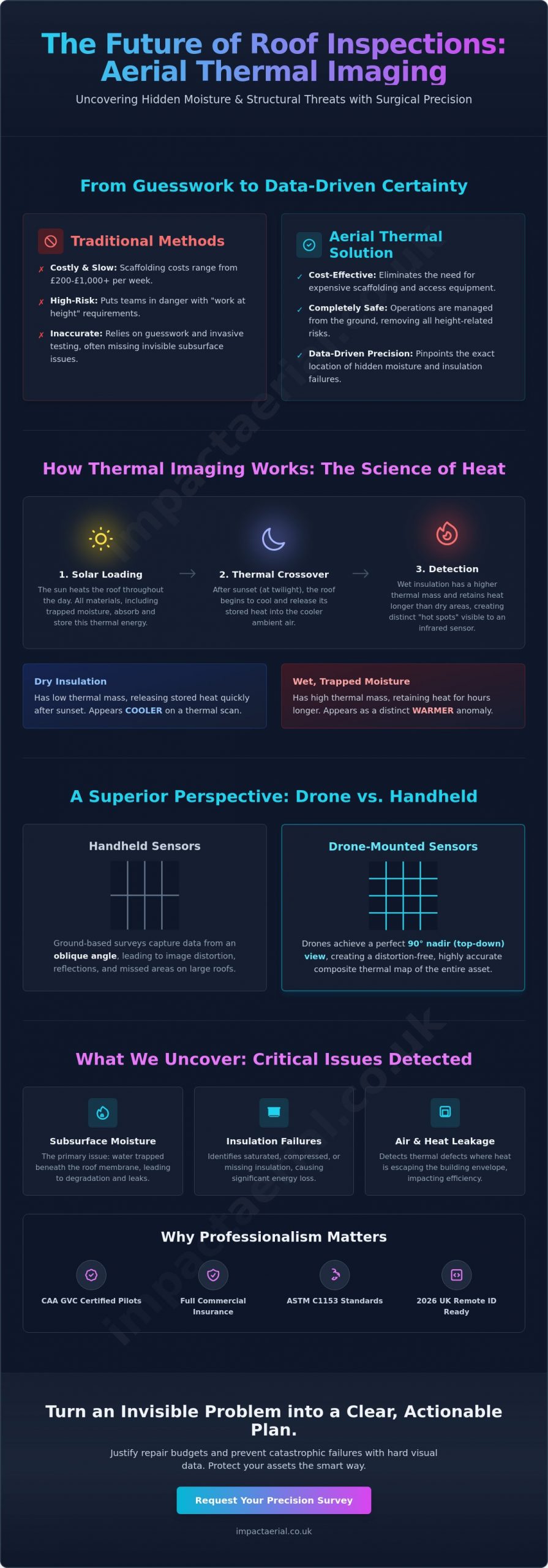
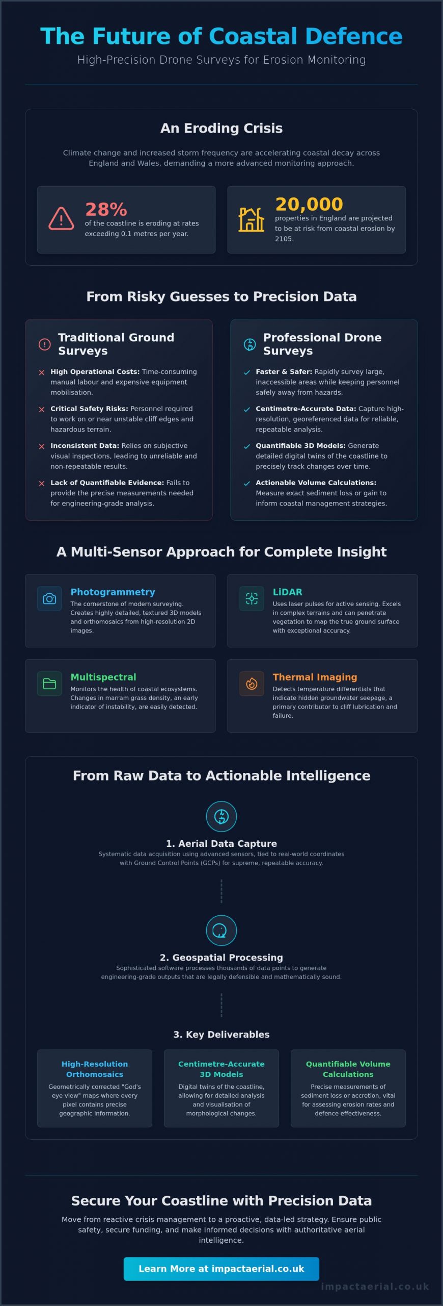
With 28% of the coastline across England and Wales eroding at rates exceeding 0.1 metres per year, can your current monitoring strategy provide the precision required for 2026? You’re likely familiar with the logistical strain of traditional ground-based surveys, including high operational costs and the genuine health and safety risks of surveying unstable cliff edges. Relying on inconsistent visual inspections instead of a professional drone survey for coastal erosion monitoring often leaves you without the quantifiable data needed for critical coastal management.
Discover how high-precision drone data is revolutionising the industry, offering faster, safer, and more accurate erosion monitoring than traditional methods. By leveraging advanced sensors, you can now generate high-resolution 3D models and quantifiable volume calculations of sediment loss with absolute confidence. This guide details the essential technical standards, from LiDAR capabilities to the latest UK drone classifications, ensuring your operations remain both compliant and authoritative in a shifting landscape.
Key Takeaways
- Learn how to select between LiDAR and Photogrammetry sensors to capture the most accurate geospatial data across diverse shoreline terrains.
- Understand the operational advantages of a professional drone survey for coastal erosion monitoring, specifically how it mitigates safety risks on unstable cliff edges.
- Discover the essential planning phases for a successful monitoring programme, including the critical synchronisation of flights with local tide times and weather windows.
- Navigate the complexities of UK regulatory compliance by understanding the requirements for CAA GVC certification and operating within restricted environmental zones.
- Identify how to translate high-precision aerial data into quantifiable 3D models and sediment volume calculations to support long-term coastal management strategies.
Understanding Drone Surveys for Coastal Erosion Monitoring
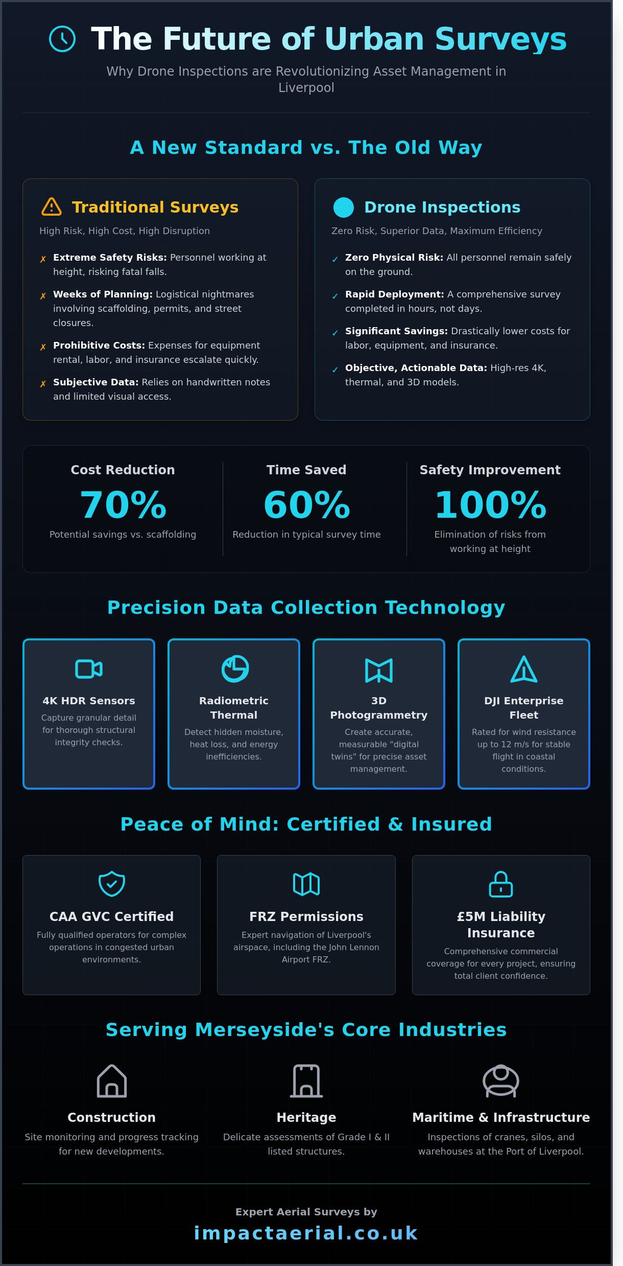
Coastal monitoring via Unmanned Aerial Vehicles (UAVs) involves the systematic acquisition of high-resolution geospatial data to track changes in shoreline morphology. This methodology replaces traditional, subjective visual assessments with measurable, repeatable evidence. With approximately 28% of the coast in England and Wales experiencing coastal erosion at rates higher than 0.1 metres per year, the demand for high-frequency data has never been more urgent. Modern environmental management requires a level of precision that only aerial technology can provide at scale.
Stakeholders ranging from local councils in Norfolk and East Riding to private developers are facing unprecedented challenges. Climate change and increased storm frequency have accelerated the rate of UK coastal decay, putting an estimated 20,000 properties in England at risk by 2105. A professional drone survey for coastal erosion monitoring provides the technical depth required to manage these risks. It moves the conversation from reactive crisis management to proactive, data-led strategy, allowing for more efficient allocation of resources and public safety measures.
To better understand the practical application of these systems in the field, watch this demonstration of high-precision hardware in a coastal environment:
The Role of Aerial Data in Risk Mitigation
Meticulous data capture allows specialists to identify structural anomalies, such as tension cracks, long before they lead to cliff failure. By detecting these shifts early, authorities can implement exclusion zones or reinforcement measures with higher confidence. This aerial intelligence serves as critical evidence when local authorities apply for coastal defence funding or when developers submit planning applications for vulnerable sites. Establishing a robust baseline is the first step. Without historical data to compare against, it’s impossible to calculate the true rate of decay or the effectiveness of existing defences.
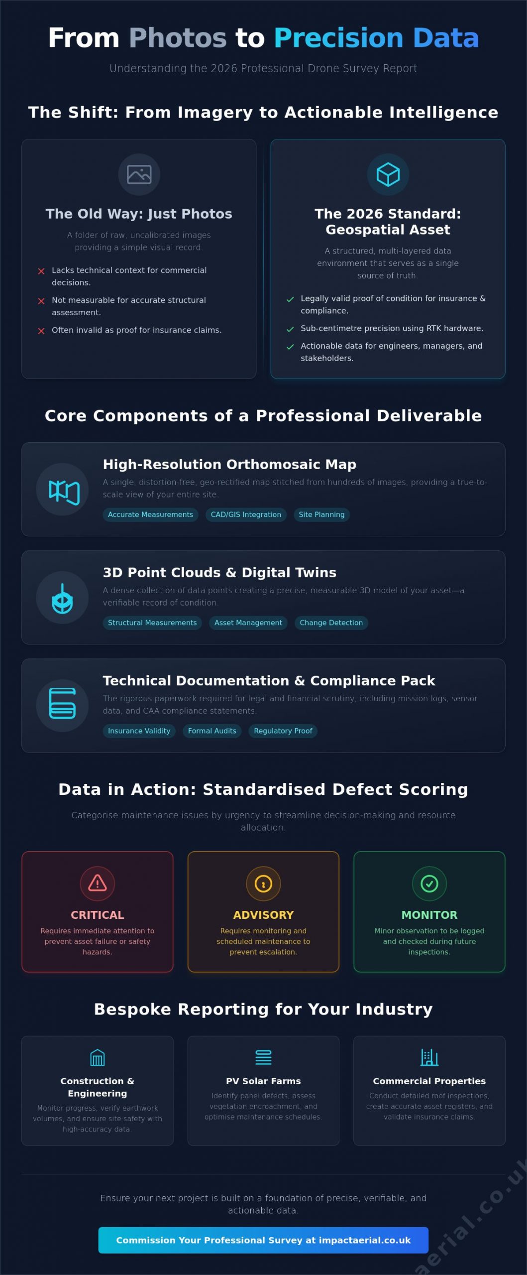
Visual Imagery vs. Geospatial Data
There is a significant distinction between simple aerial photography and geospatial intelligence. While 4K video is excellent for reporting, it doesn’t offer the centimetre-accurate 3D mapping required for engineering-grade analysis. A professional drone survey for coastal erosion monitoring utilises orthomosaics, which are geometrically corrected aerial images. These provide a “God’s eye view” where every pixel contains geographic information. To ensure this data remains reliable in complex maritime environments, we utilise Ground Control Points (GCPs). These physical markers on the ground tie the aerial data to real-world coordinates, ensuring that year-on-year comparisons are mathematically sound and legally defensible.
Sensor Technology: LiDAR, Photogrammetry, and Multispectral
Precision in coastal monitoring depends entirely on the chosen sensor payload. While visual inspections provide a surface-level narrative, a professional drone survey for coastal erosion monitoring utilises a suite of advanced sensors to capture specific environmental variables that the human eye cannot detect. These technologies allow us to move beyond simple photography into the realm of quantifiable geospatial intelligence. By selecting the correct sensor, we can identify the underlying causes of instability, such as hidden groundwater seepage or shifting vegetation patterns, with absolute technical certainty.
Photogrammetry remains the cornerstone of modern surveying, using high-resolution 2D images to reconstruct 3D environments. However, for more complex terrains, LiDAR (Light Detection and Ranging) offers an active sensing solution that measures distances using laser pulses. We also deploy multispectral sensors to monitor the health of coastal ecosystems, as changes in marram grass density often precede physical sand loss. Thermal imaging adds another layer of risk mitigation; it detects temperature differentials that indicate groundwater seepage, a primary contributor to cliff lubrication and subsequent failure.
When to Choose LiDAR for Coastal Surveys
LiDAR is the gold standard for surveying “soft” cliffs where heavy vegetation or marram grass obscures the soil. Unlike traditional cameras, LiDAR’s unique ability to ‘see through’ foliage allows for the creation of accurate Digital Terrain Models (DTMs) by filtering out vegetation to reach the true ground surface. This capability is essential for coastal mapping with drones in areas where obscured slopes might hide significant structural risks. It’s particularly effective in low-light conditions or high-contrast environments where shadows might confuse standard photogrammetry software.
The Power of Photogrammetry for 3D Modelling
Photogrammetry excels in generating high-detail “Digital Twins” of coastal infrastructure, such as sea walls, groynes, and piers. It’s an exceptionally cost-effective method for conducting regular beach volume checks, providing the high-resolution texture maps needed to identify fine-line cracks in masonry or concrete defences. The resulting data integrates seamlessly into Geographic Information Systems (GIS), allowing local authorities to perform long-term sediment tracking and volumetric analysis. If you’re managing a complex site and need to determine which sensor will yield the most actionable data, our specialists can guide you through our professional drone commercial property surveys and environmental monitoring options.
By combining these sensor outputs, we create a comprehensive data set that serves as a legal and technical baseline for all future coastal management decisions. Whether you’re tracking millimetre-scale shifts in a cliff face or calculating the loss of thousands of cubic metres of sand after a winter storm, the right sensor technology ensures your data is both accurate and defensible.
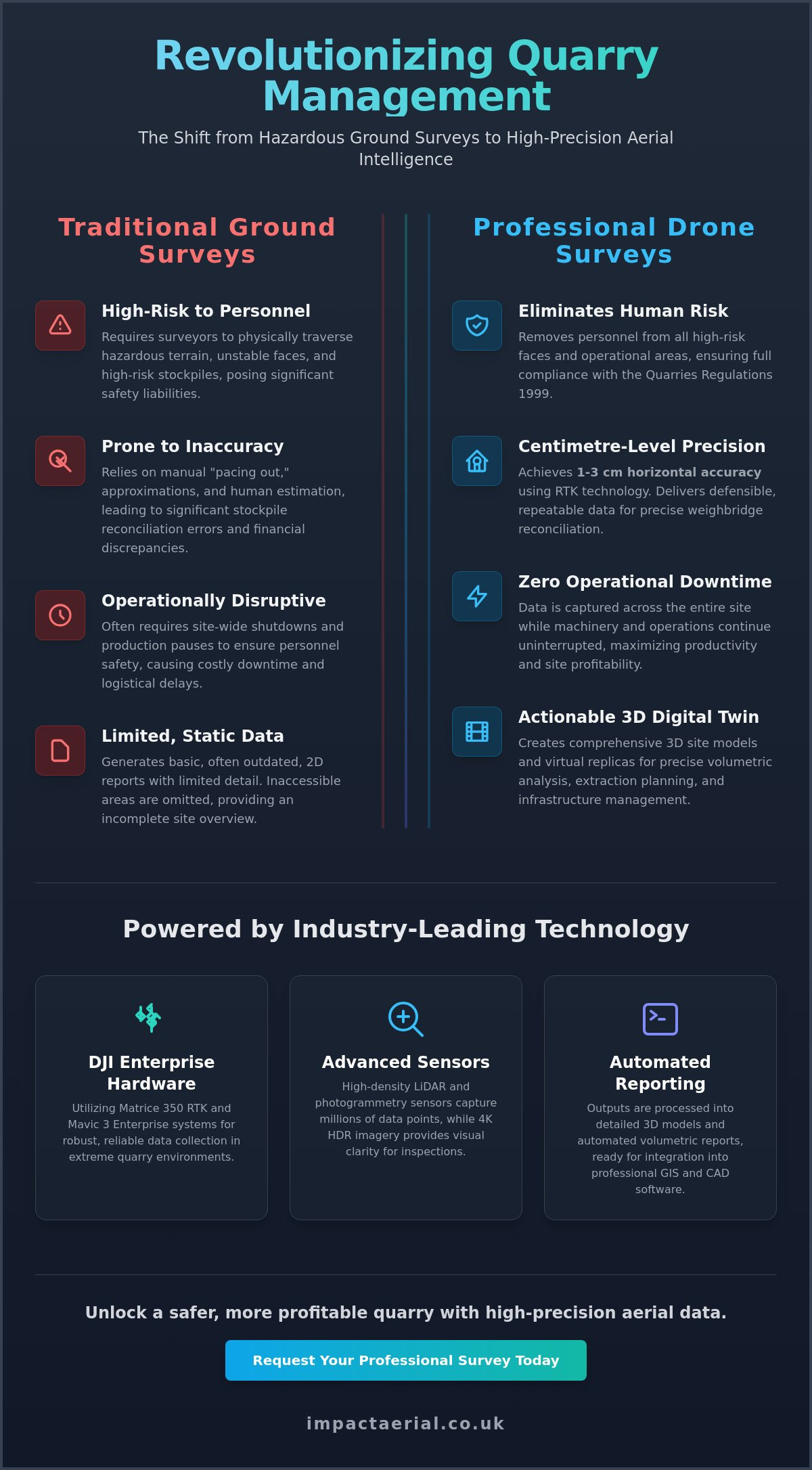
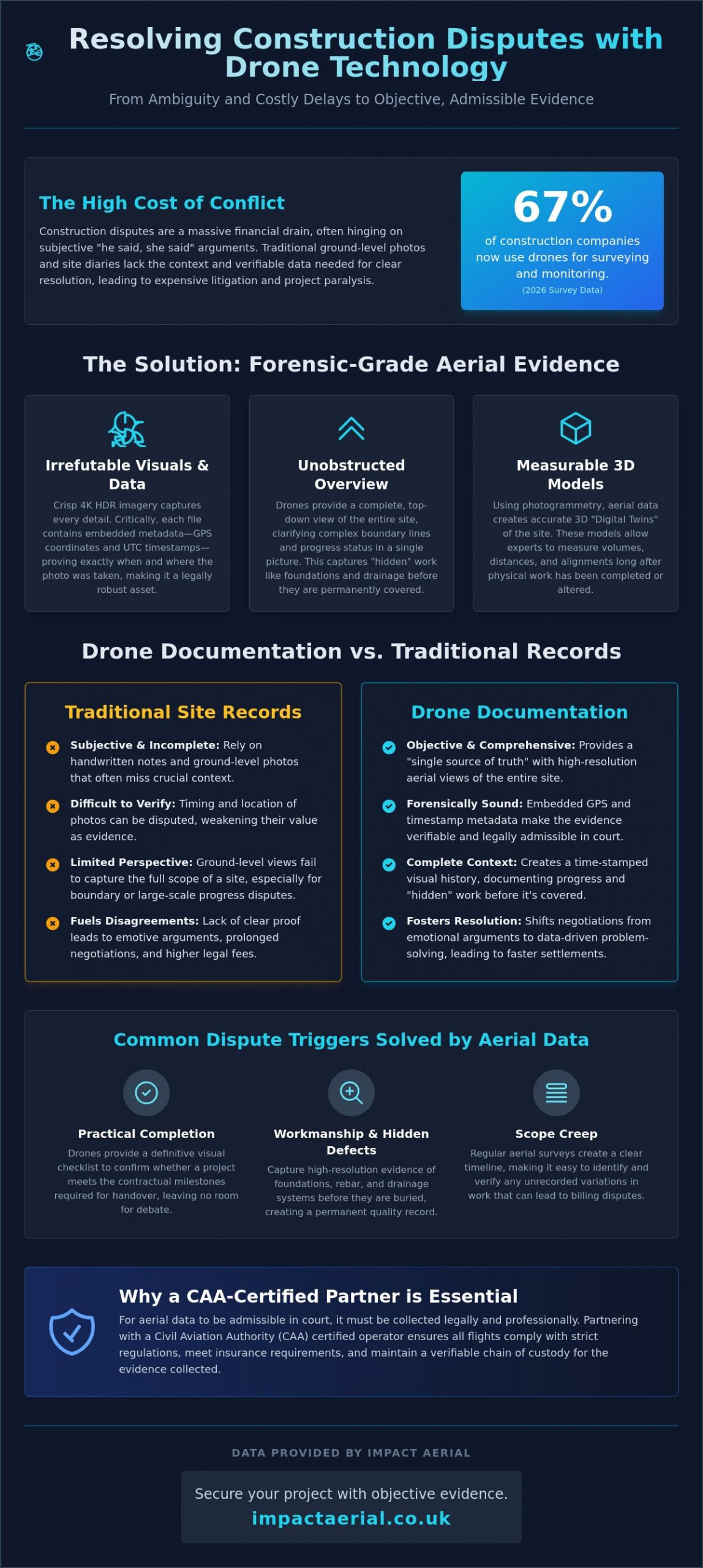
Drone vs. Traditional Coastal Surveying Methods
Traditional coastal surveying often requires personnel to manually traverse intertidal zones and cliff tops with GNSS poles. This legacy approach is inherently slow; it often takes several days to cover a stretch of coastline that a professional drone can map in a few hours. By transitioning to a drone survey for coastal erosion monitoring, you’re not just increasing speed but fundamentally changing the depth of your data. While manual methods rely on sparse transects every 50 to 200 metres, aerial platforms capture millions of data points across the entire surface, leaving no gaps in your environmental record.
Safety remains a primary driver for adopting UAV technology. Traditional methods frequently put surveyors at risk, requiring them to access unstable cliff edges or navigate dangerous tidal flats. Aerial surveys remove the need for physical access to these hazardous areas entirely. Additionally, drones offer a zero-footprint solution. This is particularly vital for Sites of Special Scientific Interest (SSSIs) where foot traffic or heavy equipment might disturb sensitive habitats. Research into USGS remote sensing technologies confirms that these non-invasive methods provide superior data without the ecological cost of ground-based operations.
Cost-Benefit Analysis for Local Authorities
Local authorities often find that drones significantly reduce the logistical overhead associated with sea vessels or crewed aircraft. While RICS notes that traditional surveys are typically conducted every six months to two years, the cost-efficiency of drones allows for “event-based” monitoring. This means you can deploy a team immediately after a major storm to assess damage in real time. This proactive approach offers a far higher long-term ROI; early detection of structural weaknesses in sea defences can prevent catastrophic infrastructure loss and the multi-million pound repair bills that follow.
Accuracy and Precision Standards
A common misconception is that aerial data is less precise than ground-based measurements. Modern RTK (Real-Time Kinematic) drones achieve sub-5cm absolute accuracy, providing engineering-grade data that rivals any traditional method. We provide 1cm-per-pixel resolution, allowing for the detection of hairline fractures in sea walls that would be invisible on a standard 200-metre transect. For a more comprehensive look at how we maintain these standards, read our Drone Survey: The Complete Guide to Aerial Data Collection. This precision ensures that your coastal management decisions are based on the most rigorous data available in 2026.
Implementing a Coastal Erosion Monitoring Programme
Executing a structured drone survey for coastal erosion monitoring requires meticulous planning across five distinct phases. Phase 1 begins with defining the Area of Interest (AOI) and determining the required Ground Sample Distance (GSD); higher resolution is typically needed for cliff face crack detection than for general beach volume checks. Phase 2 involves rigorous pre-flight planning. In the UK, this means synchronising flight windows with low tide times to ensure maximum beach exposure and monitoring weather patterns to stay within safe wind speed tolerances.
Phase 3 is the operational stage, where we deploy high-tier DJI Enterprise hardware, such as the Matrice 350 RTK, to capture data with centimetre-level positioning accuracy. Once the flight is complete, Phase 4 moves into post-processing. Here, we use photogrammetry software to transform thousands of raw images into georeferenced point clouds and orthomosaics. Finally, Phase 5 delivers reporting and actionable insights, providing local authorities with the evidence needed for immediate safety interventions or long-term defence planning.
Analysing Volume and Elevation Changes
We use specialized ‘swipe’ tools to overlay orthomosaics from different years, allowing for a direct visual comparison of shoreline retreat. This process quantifies sediment movement with high precision, answering exactly how many cubic metres of sand were lost during the last winter season. Digital Elevation Models (DEMs) provide a colour-coded representation of height data that makes even millimetre-scale terrain shifts visually apparent for analysis.
AI and Automated Change Detection
Modern monitoring programmes now integrate machine learning to automatically flag areas where erosion exceeds pre-defined thresholds. These algorithms track the retreat of the ‘cliff toe’ over multiple survey cycles, providing an objective metric of decay. Standardising this data ensures it’s compatible with multi-agency databases, such as those maintained by the Environment Agency and RICS. If you require a robust, compliant framework for your site, our team provides expert construction site monitoring and environmental data services to ensure long-term stability.
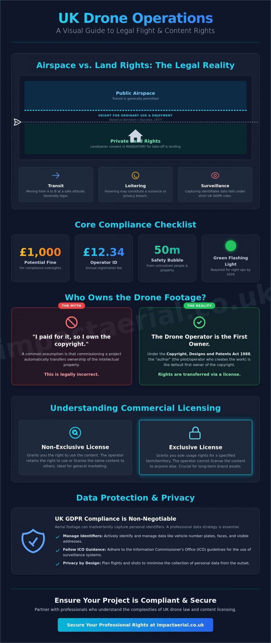
UK Compliance: Why Professional Certification Matters
Operating a professional drone survey for coastal erosion monitoring in the UK requires more than just technical skill; it demands strict adherence to Civil Aviation Authority (CAA) regulations. In 2026, the legal framework has become more defined, with all new drones requiring UK-specific class marks from UK0 to UK6. For complex commercial missions near sensitive shorelines, holding a General Visual Line of Sight (GVC) certificate is the standard requirement. This certification demonstrates a pilot’s competence in managing risk and navigating the specific operational challenges of maritime environments.
Navigating the geography of the coast often involves flying within Flight Restriction Zones (FRZs) near regional airports or military installations. Furthermore, many eroding cliffs are designated as Sites of Special Scientific Interest (SSSIs). Conducting surveys in these areas requires specific permissions from Natural England to ensure that aerial operations don’t disturb protected wildlife. To mitigate these risks, £5m commercial liability insurance has become the industry standard. This level of coverage provides the necessary reassurance to local councils and private developers that they’re partnering with a compliant and safety-conscious operator.
Safety Protocols in Maritime Environments
Coastal environments present unique technical hurdles that differ significantly from inland surveys. High winds and corrosive salt spray can impact hardware performance, requiring pilots to use aircraft with high IP ratings and robust wind resistance. Public safety is another critical pillar of our protocol. Because coastal paths and beaches are often public spaces, we implement strict ground-control measures to manage access during flight windows. Understanding these rules is vital for any stakeholder; you can learn more about the current regulatory landscape in our guide to the UK Drone License: A Simple Guide to CAA Rules in 2026.
The Impact Aerial Standard
Impact Aerial maintains a meticulous approach to data-centric processes and regulatory officialdom. We don’t just fly; we provide a technical consultancy service that prioritises precision and legal compliance. While our operations are often based out of Birmingham, we provide nationwide coverage, bringing specialist expertise to every corner of the UK coastline. We’re proud of our professional affiliations and our ability to deliver high-tier geospatial output that stands up to the most rigorous engineering scrutiny. If you’re ready to transition from inconsistent visual inspections to a georeferenced monitoring programme, contact Impact Aerial for a professional coastal survey consultation to discuss your project’s specific requirements.
Securing the Future of Coastal Management with Geospatial Intelligence
The transition from manual inspections to high-precision aerial data is a fundamental shift in how we protect vulnerable shorelines. By integrating advanced LiDAR and photogrammetry, you gain access to quantifiable volume calculations and centimetre-accurate 3D models that traditional methods cannot match. This data-centric approach ensures that every management decision is backed by rigorous technical evidence rather than visual estimation. A professional drone survey for coastal erosion monitoring provides the necessary baseline for tracking long-term shifts in shoreline morphology with absolute technical certainty.
Impact Aerial stands as a trusted specialist in this expanding market. Our operations are led by CAA GVC Certified Pilots who utilise high-tier DJI Enterprise hardware to deliver industry-leading results. With £5m commercial liability insurance and a meticulous focus on UK regulatory compliance, we provide the reassurance and tangible data your project requires. Request a Professional Drone Survey Quote from Impact Aerial to begin your monitoring programme. We’re ready to help you navigate the complexities of environmental management with precision and confidence.
Frequently Asked Questions
How accurate are drone surveys for monitoring coastal erosion?
Drone surveys provide engineering-grade accuracy, typically achieving sub-5cm absolute accuracy when using RTK-enabled hardware. This level of precision allows for the detection of minute structural shifts and hairline fractures in sea defences. By integrating Ground Control Points (GCPs), we ensure that every dataset is georeferenced to national grid standards, providing a reliable baseline for year-on-year comparisons.
Can drones fly in high winds common on the UK coast?
Professional Enterprise drones are designed to operate in challenging coastal conditions, with many models offering wind resistance up to 12 or 15 metres per second. However, safety remains our primary concern. We monitor real-time anemometer data during every mission to ensure the aircraft remains within its technical tolerances. If wind speeds exceed safe limits or gust unpredictably, we suspend operations to protect the equipment and the public.
Do I need special permission to survey a SSSI coastal area?
Yes, conducting a drone survey for coastal erosion monitoring within a Site of Special Scientific Interest (SSSI) requires formal consent from Natural England. These areas are ecologically sensitive, and drone flight can potentially disturb nesting birds or rare habitats. As part of our meticulous planning process, we handle these regulatory applications to ensure all operations are fully compliant with environmental protection laws.
What is the difference between LiDAR and Photogrammetry for beach surveys?
The primary difference lies in how data is captured. Photogrammetry reconstructs 3D models from high-resolution 2D images, making it ideal for open beaches and masonry structures. LiDAR uses active laser pulses that can penetrate dense vegetation or marram grass to map the true ground surface. While photogrammetry is often more cost-effective for clear terrain, LiDAR is essential for “soft” cliffs with heavy foliage.
How often should coastal erosion surveys be conducted?
We recommend conducting surveys at least twice a year to capture seasonal sediment shifts. Ideally, these should occur in spring and autumn to track the impact of winter storms. However, “event-based” monitoring is also critical. Deploying a drone immediately after a major storm surge provides invaluable data on immediate volume loss, allowing local authorities to assess the integrity of coastal defences before further damage occurs.
What data formats are provided after a drone coastal survey?
Our post-production services deliver data in industry-standard formats compatible with most GIS and CAD software. Common outputs include georeferenced orthomosaics (.GeoTIFF), high-density point clouds (.LAS or .LAZ), and 3D mesh models (.OBJ). We also provide Digital Elevation Models (DEMs) and Digital Terrain Models (DTMs), which are essential for conducting volumetric analysis and sediment tracking across multiple survey cycles.
Is a drone survey cheaper than a traditional land survey?
A professional drone survey for coastal erosion monitoring is significantly more cost-effective for large-scale projects, often reducing expenses by 50% to 75% compared to traditional ground-based methods. The primary savings come from reduced logistical overhead and faster data collection speeds. While a ground team might take days to traverse a kilometre of unstable cliff, a drone can map the same area in under an hour.
How do drones help in calculating volume loss on cliffs?
Drones enable precise volumetric calculations by comparing 3D point clouds or Digital Elevation Models from different time periods. By “subtracting” a newer survey from an older baseline, software can calculate the exact volume of material lost in cubic metres. This allows engineers to quantify the rate of cliff retreat and identify specific areas where the “cliff toe” is becoming undercut, which is a primary indicator of imminent failure.