Professional Drone Services for Local Councils: A 2026 Guide to Efficiency and Compliance

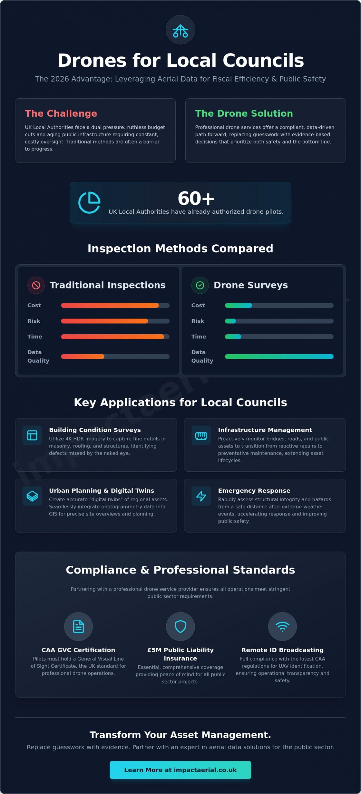
Did you know that over 60 UK local authorities have already authorized drone pilots to manage their regional assets? This shift marks the end of drones being viewed as a novelty. By 2026, they’ve become indispensable fiscal tools for managing the public realm. You’re likely feeling the pressure of ruthless budget cuts while managing aging infrastructure that requires constant oversight. The high cost and physical risk of traditional scaffolding or manual inspections often feel like a barrier to progress. Utilizing professional drone services for local councils offers a compliant, data-driven path forward that prioritizes both safety and the bottom line.

We’ve designed this guide to show you exactly how UK authorities are reducing maintenance lead times and improving public safety through expert aerial surveys. You’ll learn how to navigate the latest CAA hurdles, including mandatory Remote ID broadcasting, while securing the defensible evidence needed for audits. From thermal surveys of solar farms to detailed property inspections, we’ll preview the technical standards and operational workflows that turn complex aerial data into actionable asset management strategies. It’s time to replace guesswork with evidence-based decision making.

Key Takeaways

  • Understand how to leverage professional UAV operations to manage regional assets more efficiently within the challenging 2026 fiscal landscape.
  • Explore the diverse applications of drone services for local councils, from conducting 4K HDR building condition surveys to enhancing urban planning accuracy.
  • Evaluate the safety and speed advantages of aerial data collection over traditional scaffolding and manual inspection methods.
  • Identify the essential compliance standards for public sector partnerships, including the requirement for CAA GVC certification and comprehensive £5m liability insurance.

Why UK Local Authorities are Integrating Drone Technology in 2026

Professional drone services for local councils represent the deployment of a sophisticated Unmanned aerial vehicle (UAV) for the meticulous management of public assets. By 2026, the fiscal landscape for UK local authorities has become increasingly constrained. Councils are tasked with maintaining extensive infrastructure while facing significant budget shortfalls. This environment has accelerated the adoption of drone technology. It’s no longer an experimental hobbyist tool; it’s a critical component of professional service delivery.

Local authorities must meet strict statutory liabilities regarding community safety and structural integrity. Professional drone operations provide a high-tier, compliant method for meeting these obligations without the prohibitive costs of traditional methods. It allows departments to transition from reactive repairs to proactive asset management, ensuring that public funds are used with maximum efficiency.

To better understand the legal context of council interactions with drone technology, watch this helpful video:

The Economic Case for Council Drones

Aerial surveys provide a precise alternative to traditional inspection methods. Setting up scaffolding or implementing road closures for a simple roof or bridge inspection is often a logistical and financial burden. Using drone data streamlines these processes, allowing for rapid deployment and data-centric decision making. This efficiency extends the lifecycle of public buildings by identifying minor defects before they become catastrophic failures. Additionally, the high-resolution evidence captured during drone services for local councils often strengthens government funding and grant applications by providing undeniable, visual proof of asset condition and the necessity of investment.

Improving Community Safety and Response

Public safety is a primary concern for any district or borough council. When extreme weather events occur, traditional inspection teams are often delayed by safety risks or accessibility issues. Professional drone pilots can provide a rapid assessment of civic structures from a safe distance, identifying hazards immediately. This proactive monitoring is essential for preventing emergency infrastructure failures. High-resolution aerial perspectives allow for the detection of subtle changes in masonry or drainage that manual inspections might miss. It’s about providing psychological comfort to the community through reliable, technology-driven oversight and meticulous data collection.

Key Applications: From Asset Management to Urban Planning

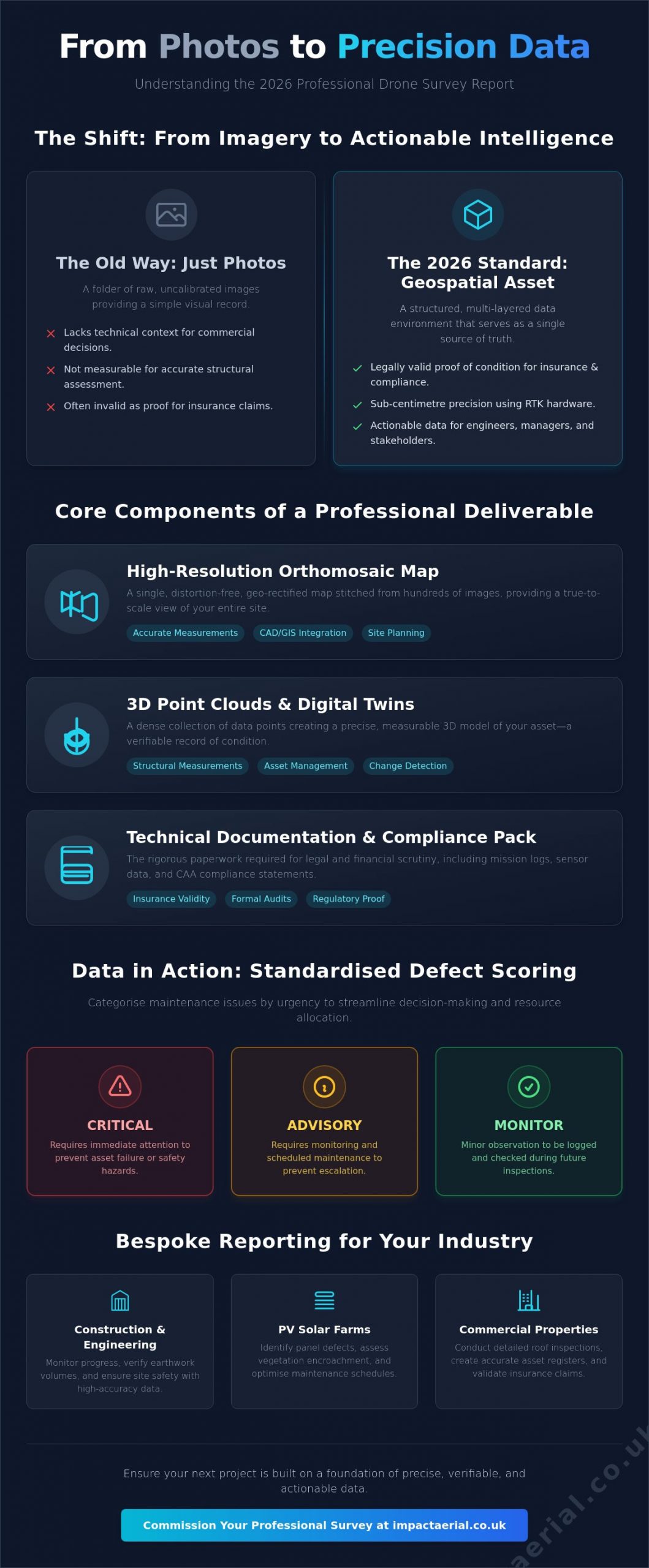
The versatility of drone services for local councils allows departments to move beyond simple photography into high-precision data acquisition. A recent report on drone use by Local Government in England highlights how these tools are transitioning from novelty to necessity. Central to this utility is the deployment of 4K HDR imagery. This high dynamic range is vital for building condition surveys, as it captures detail in both deep shadows and bright highlights, ensuring that cracks in masonry or defects in dark roofing materials aren’t missed during the analysis phase.

Council officers don’t just need pictures; they need actionable data. Modern aerial platforms allow for the seamless integration of captured imagery and photogrammetry into existing Geographic Information Systems (GIS) and asset management software. This creates a “digital twin” of regional assets, allowing for precise temporal monitoring of deterioration. In regions like the West Midlands, this technology is actively supporting large-scale urban regeneration projects by providing accurate site overviews that traditional ground-level photography cannot match.

Infrastructure and Building Inspections

Maintaining the structural health of schools, libraries, and leisure centres is a constant challenge. Utilizing advanced drone survey techniques allows for rapid assessments of roofs and façades without the need for expensive access equipment. This is particularly beneficial for:

  • Multi-storey car parks: Identifying concrete spalling and drainage issues in high-risk environments.
  • Historic bridges: Monitoring structural integrity over water or active rail lines without service interruptions.
  • Heritage sites: Providing a meticulous non-contact record of listed buildings without risking fragile masonry.

If your department is looking to enhance its oversight of civic assets, you can explore our professional drone survey services to see how we provide these detailed perspectives.

Environmental and Planning Support

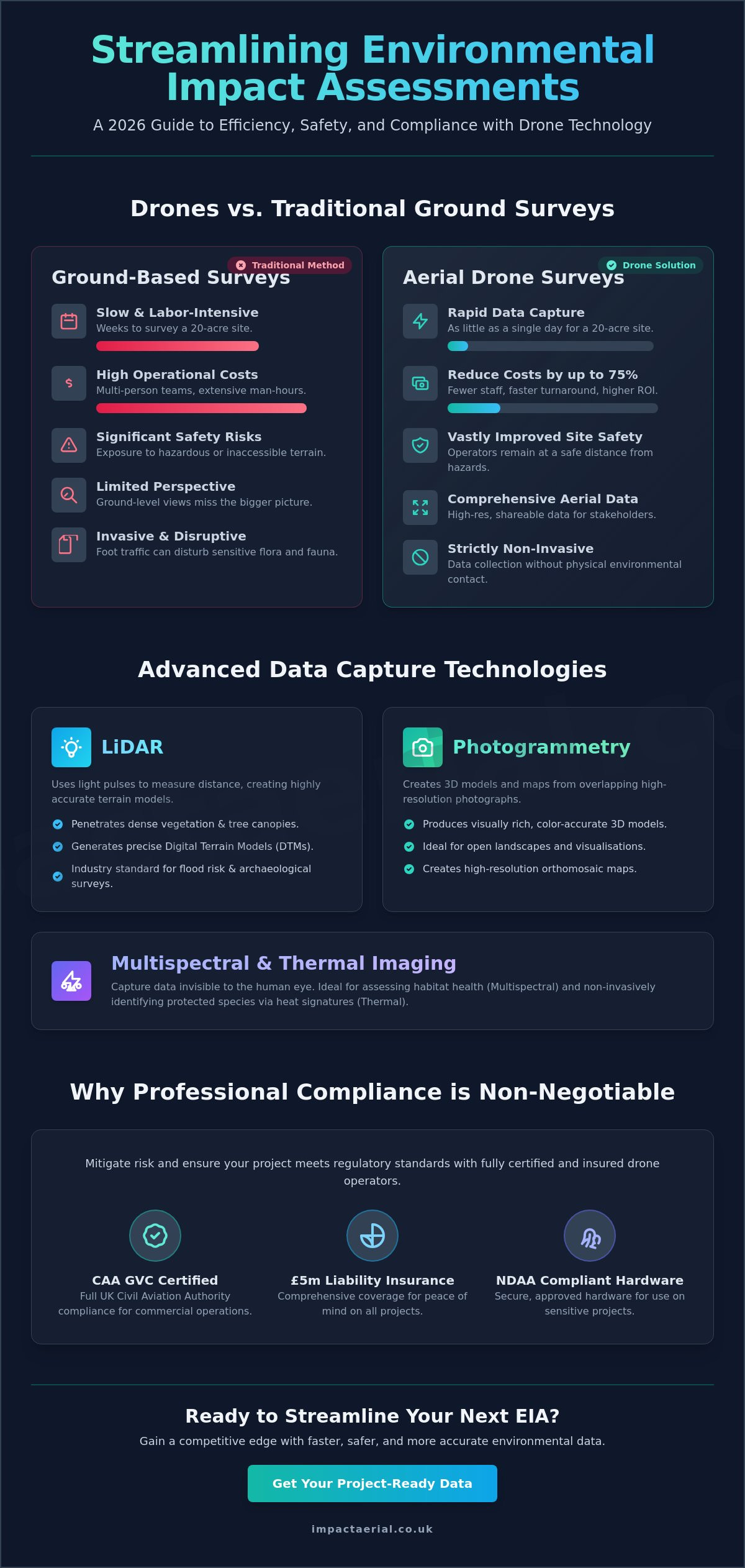
Planning departments use drones to monitor flood plains and track coastal erosion with centimetre-level precision. This mapping data is essential for developing robust environmental protection strategies and supporting planning applications. Additionally, drones are effective tools for tracking fly-tipping and illegal land use in sprawling rural council areas, providing the defensible evidence required for enforcement. For new housing developments, aerial site data offers a comprehensive view of progress, ensuring that regeneration projects remain on schedule and within their regulatory bounds. This level of oversight ensures that every development phase is documented with technical precision and total compliance.

Professional Drone Services for Local Councils: A 2026 Guide to Efficiency and Compliance

Comparing Drone Surveys to Traditional Inspection Methods

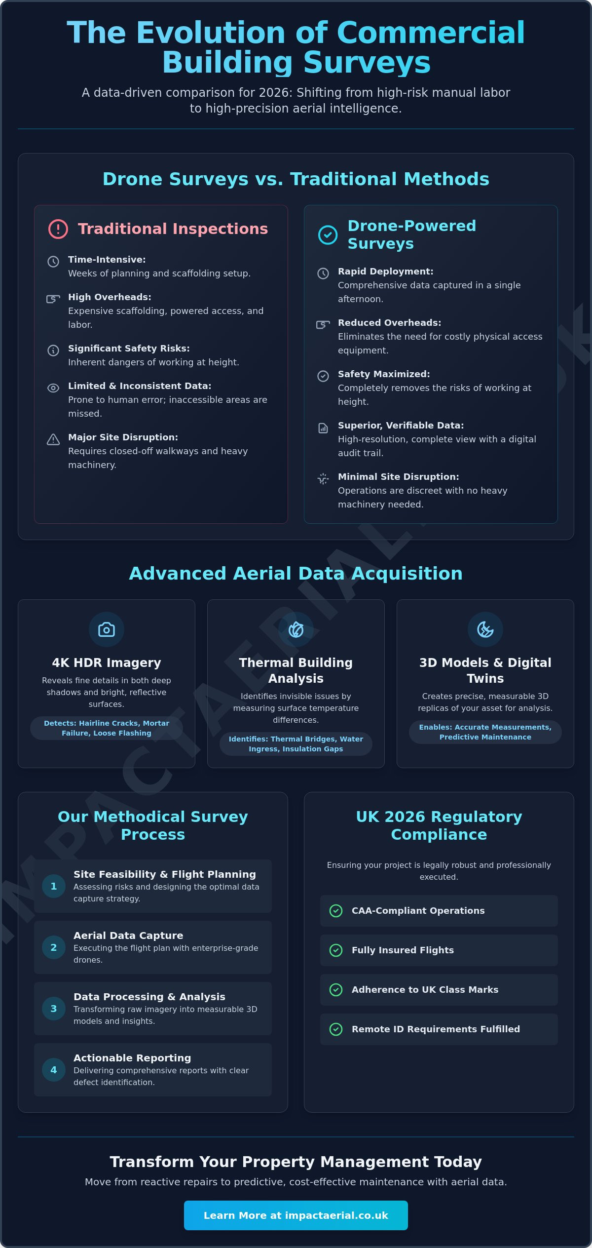
Traditional methods of inspecting council infrastructure are inherently resource-heavy and fraught with logistical challenges. For decades, local authorities have relied on scaffolding, cherry pickers, and rope access teams to assess the condition of civic buildings and bridges. Integrating drone services for local councils provides a safer, more sustainable alternative that addresses these historic pain points. By removing personnel from “Work at Height” environments, councils significantly reduce their liability and the potential for workplace accidents. This transition doesn’t just protect staff; it also aligns with modern sustainability goals. While traditional access platforms often require petrol-powered heavy machinery and transport vehicles, electric UAVs operate with a negligible carbon footprint and minimal noise pollution.

The speed of data acquisition is another critical differentiator. A manual inspection of a large leisure centre or housing estate can take weeks of planning and execution. In contrast, a professional drone flight can capture the same area in hours. This rapid time-to-data ensures that maintenance teams receive high-density information, such as 4K video and 3D virtual tours, almost immediately. This superior data density allows for a more nuanced understanding of asset health than a manual inspector with a clipboard could ever provide.

Cost and Time Efficiency Analysis

The return on investment when deploying a professional survey drone is evident in the reduction of project overheads. For large-scale council estates, the cost of erecting scaffolding alone can exceed the entire budget of an aerial survey. By avoiding these physical installations, councils can reduce topographic survey timelines from weeks to just a few days. Furthermore, aerial inspections minimise public disruption. There’s no need for extensive road closures or the deployment of heavy plant machinery that blocks pavements and disturbs residents. It’s a methodical approach that prioritises both the council’s budget and the community’s daily life.

Data Accuracy and Audit Trails

Meticulous record-keeping is a cornerstone of public sector accountability. Every image captured during an aerial mission is geo-tagged, providing precise location referencing that is vital for internal audits and statutory reporting. This allows councils to create a “digital twin” of their assets, enabling a direct year-on-year comparison to track structural deterioration with mathematical precision. When disputes arise, professional drone photography provides indisputable evidence for insurance claims or contractor assessments. This level of transparency ensures that every decision made by the council is supported by high-tier, defensible data, providing psychological comfort to stakeholders and ensuring total regulatory compliance.

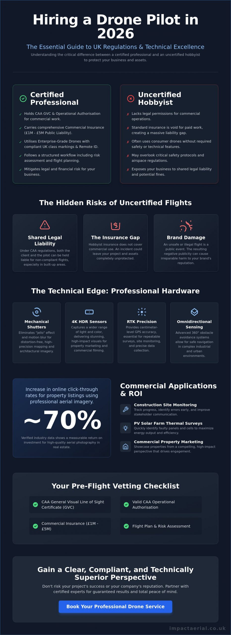
Compliance within the public sector is non-negotiable. As of January 1, 2026, the regulatory landscape has tightened significantly with the mandatory implementation of Remote ID broadcasting for the majority of professional-grade aircraft. When procuring drone services for local councils, the first point of verification must be the pilot’s certification. Councils should only engage pilots who hold a CAA General Visual Line of Sight Certificate (GVC). This qualification demonstrates a level of competence and safety awareness that far exceeds consumer-grade operations, ensuring that missions in complex environments are conducted with technical precision.

Risk mitigation is the cornerstone of every successful aerial operation. Public sector contracts typically mandate a minimum of £5 million in commercial liability insurance. This provides a necessary layer of financial security for the council, covering operations in high-traffic public areas. Impact Aerial, based in Birmingham, specialises in managing these complex flight permissions within congested urban environments. This involves meticulous coordination with local stakeholders and strict adherence to safety protocols that protect both the public and the council’s reputation. This ensures that drone services for local councils are delivered with the highest level of accountability.

If your authority requires a fully compliant aerial partner for upcoming urban projects, you can contact our Birmingham-based specialist team for a detailed consultation.

Understanding 2026 UK Drone Laws

The 2026 regulatory framework introduces strict requirements for UK class marks (UK0 to UK6) on all new hardware. Verifying a professional drone license is the only way to ensure your provider understands these technical nuances. There’s a vast difference between consumer hardware and DJI Enterprise commercial standards, which offer enhanced redundancy and data security. Every council project requires a site-specific risk assessment and a comprehensive flight plan. This meticulous planning is what separates a compliant professional service from a high-risk liability.

Privacy and Public Relations

Managing public perception is just as important as managing the flight itself. Local authorities must adhere to strict GDPR and data protection standards when surveying residential areas. Best practices include notifying residents well in advance of any aerial filming or surveying activities. All sensitive council data should be handled via encrypted storage and secure transfer protocols to prevent unauthorised access. Maintaining this level of transparency is essential for building community trust. When residents understand that the technology is being used for their safety and the improvement of local infrastructure, the transition to drone-led management becomes much smoother.

Partnering with Impact Aerial: Expert Drone Solutions for the Public Sector

Impact Aerial operates as a specialized technical consultant for the public sector, offering much more than a simple “pilot for hire” service. Based in Birmingham but providing comprehensive national UK coverage, we provide a structured, professional approach to drone services for local councils. Our operations utilize high-tier DJI Enterprise technology equipped with 4K HDR cameras. This hardware ensures that every frame of data meets the qualitative and technical standards required for official audits, structural assessments, and public records. We manage the entire lifecycle of an aerial project, from the initial regulatory consultation through to meticulous post-production services, ensuring a seamless flow of information from the site to the council office.

Our role as a technical partner means we don’t simply capture imagery; we provide the defensible evidence required for high-stakes decision making. By leveraging enterprise-grade hardware, we offer superior data security and operational redundancy, which is critical when working near sensitive public infrastructure. This meticulousness extends to our post-production workflow, where raw aerial data is transformed into structured reports or immersive virtual tours. These outputs allow council officers and stakeholders to visualize complex asset conditions without ever having to leave their desks, providing psychological comfort and tangible efficiency gains.

Why West Midlands Councils Choose Impact Aerial

Authorities across the West Midlands often require a partner who understands regional topography and the specific challenges of dense urban environments. Our team combines this deep local knowledge with strict CAA-certified professional standards, ensuring every flight is compliant and safe. We have a proven track record in complex aerial filming drone projects where safety-conscious execution is the priority. Whether it’s monitoring a multi-million pound regeneration site or conducting a sensitive heritage survey, our reliability ensures that council requirements are not just met, but exceeded. We invite council officers to discuss bespoke requirements for asset management or urban planning to see how our data-centric approach can support their specific goals.

Next Steps for Procurement and Asset Managers

For procurement officers and asset managers, the path to integrating professional drone services for local councils is clear and methodical. We offer technical consultations to determine the feasibility of specific sites and provide detailed, site-specific risk assessments before any flight takes place. Our pricing models are designed for flexibility, catering to both one-off emergency surveys and long-term asset management contracts. This allows councils to scale their drone usage according to their current fiscal needs and maintenance backlogs. To begin the process, you can contact the Impact Aerial team to request a professional quote and a comprehensive project plan tailored to your authority’s unique infrastructure challenges.

Future-Proofing Council Asset Management for 2026 and Beyond

Professional drone services for local councils have transitioned from an emerging technology to a fundamental requirement for efficient infrastructure oversight. By replacing costly manual inspections with high-precision aerial surveys, authorities can drastically reduce maintenance lead times and secure the defensible data needed for statutory audits. This methodical approach ensures that limited budgets are allocated where they’re most needed, based on indisputable visual evidence captured through technical precision.

Selecting a partner that values meticulous compliance is essential for public safety and risk mitigation. Impact Aerial provides this reassurance through the deployment of CAA GVC Certified Pilots and the use of high-tier DJI Enterprise 4K HDR technology. With £5m commercial liability insurance as standard, we offer the technical reliability required for complex regional projects across the UK. It’s time to move beyond traditional inspection hurdles and embrace a more agile, data-centric strategy for your district or borough.

Ready to enhance your department’s operational efficiency? Request a professional drone service quote for your council project to begin your transition to safer, more compliant asset management. Investing in expert aerial data today ensures a more resilient and well-maintained community for tomorrow.

Frequently Asked Questions

Can local councils use drones for roof inspections on schools?

Yes, local authorities frequently deploy drones for school roof inspections to avoid the high costs and safety risks of scaffolding. This method allows for a rapid assessment of tiles, gutters, and chimney stacks while the school remains operational. It’s a non-intrusive way to identify maintenance needs before they escalate into emergency repairs. By using 4K HDR cameras, maintenance teams can zoom in on specific defects with absolute clarity.

What insurance coverage is required for council drone operations?

Public sector contracts typically require a minimum of £5 million in commercial liability insurance. This coverage must specifically cater to professional UAV operations and comply with CAA standards. It provides the council with financial protection against third-party property damage or injury during complex aerial surveys in public spaces. This high level of insurance is a standard requirement for ensuring the council’s financial security and regulatory compliance.

Do drone pilots need specific certifications to work for local authorities?

Professional pilots must hold a CAA General Visual Line of Sight Certificate (GVC) to conduct drone services for local councils. This certification ensures the pilot has undergone rigorous training in flight safety, risk assessment, and regulatory compliance. It’s the industry benchmark for commercial competence in the UK, especially for missions in congested areas. Councils should always verify this qualification before awarding any survey contracts.

How do drones help councils manage fly-tipping and environmental issues?

Drones provide high-resolution aerial evidence that helps councils identify illegal dumping sites in remote or inaccessible areas. By capturing geo-tagged imagery, environmental officers can document the scale of fly-tipping for potential legal prosecutions. This proactive monitoring acts as a powerful deterrent and streamlines regional cleanup operations. It’s a data-centric approach that allows councils to manage vast rural areas more efficiently without the need for constant ground patrols.

Are drone surveys more cost-effective than traditional scaffolding?

Drone surveys are considerably more cost-effective than traditional scaffolding because they eliminate the need for heavy equipment and lengthy setup times. A project that might take days to scaffold can be completed by a drone in just a few hours. This efficiency directly reduces labor costs and minimizes disruption to local traffic or pedestrians. It’s a streamlined workflow that delivers high-tier data at a fraction of the traditional price.

How does a council ensure public privacy during a drone survey?

Councils ensure privacy by adhering to strict GDPR protocols and anonymizing sensitive data, such as faces or license plates, during post-production editing. Residents are typically notified through official channels before any aerial filming takes place in residential areas. We use encrypted storage systems to maintain the integrity and security of all captured information, ensuring that community trust remains high throughout the survey process.

What data formats do councils receive from professional drone surveys?

Professional drone services for local councils deliver a variety of high-tier formats, including 4K HDR video and high-resolution geo-tagged JPEGs for visual inspections. For engineering and planning departments, we also provide 3D point clouds and digital surface models compatible with standard GIS and asset management software. This allows for the creation of digital twins, facilitating precise year-on-year comparisons of critical council assets and infrastructure.

Can drones operate in high-density urban areas like Birmingham city centre?

Drones can operate in high-density areas like Birmingham city centre, provided the pilot has the necessary CAA permissions and a site-specific risk assessment. These missions require meticulous planning to manage public safety and navigate complex airspace restrictions in congested urban environments. Using professional DJI Enterprise hardware ensures the necessary redundancy and signal stability for safe operations in areas with significant architectural and electronic interference.

What Does a Drone Survey Report Include? A 2026 Professional Guide

If you received 500 high-resolution aerial photos but couldn’t use a single one to prove a structural defect to your insurer, was it really a survey? Many property managers and construction leads have felt the frustration of being handed a folder of raw images without the technical context needed to make a commercial decision. It’s common to feel uncertain about whether your data meets professional standards or if it’s just a collection of nice pictures. Understanding what does a drone survey report include is the first step toward moving from simple photography to actionable geospatial data.

You deserve a report that provides clarity rather than adding to the technical jargon. We’ve designed this 2026 guide to reveal the specific maps, data sets, and insights that transform aerial footage into a professional survey. We’ll explore the essential components of a CAA-compliant report, including orthomosaic maps, digital elevation models, and the rigorous technical documentation required for insurance validity. By the end, you’ll have the confidence to commission a survey that delivers tangible results and precise data for your next commercial property or construction project.

Key Takeaways

  • Understand why a professional deliverable is a structured geospatial asset rather than a collection of photos, and learn exactly what does a drone survey report include to meet 2026 industry standards.
  • Gain insight into the technical applications of 3D Point Clouds and Digital Twins for conducting precise structural measurements and long-term asset management.
  • Learn to use standardised defect scoring to categorise maintenance issues by urgency, streamlining your decision-making process and resource allocation.
  • Discover the critical role of CAA regulatory compliance in ensuring your aerial data serves as legally valid proof of condition for insurance purposes.
  • Explore how bespoke reporting tailored to specific sectors, such as PV solar farms and construction sites, provides the precise data required for sector-specific compliance.

Understanding the Modern Drone Survey Report in 2026

A professional drone survey report is far more than a digital gallery of high-altitude pictures. In 2026, it represents a comprehensive geospatial asset that serves as a single source of truth for property managers and engineers alike. If you are questioning what does a drone survey report include, the answer lies in the transition from simple aerial photography to high-accuracy photogrammetry. This process converts hundreds of individual images into a unified, measurable data set that can be used for legal, financial, and structural assessments.

Technological advancements in 2026 have pushed accuracy levels to sub-centimetre precision. By utilizing RTK (Real-Time Kinematic) hardware and unified processing software like PIX4Dmatic, surveyors now deliver outputs that align perfectly with national grid coordinates. This level of detail ensures that every pixel carries geographical weight, making the report a valid document for insurance claims and regulatory compliance.

To see how these measurements translate into professional reporting, watch this demonstration:

From Visual Imagery to Geospatial Data

Modern drones capture images with high overlap, allowing sophisticated algorithms to reconstruct the environment in three dimensions. This is the core of Aerial Survey Methods. There is a fundamental difference between looking at a roof and actually measuring a structure. A visual inspection might show a crack, but a geospatial report identifies its exact length, width, and depth within a global coordinate system. Every data point is timestamped. This creates a rigorous audit trail that is indispensable for construction site monitoring or solar farm maintenance. It ensures that the information you receive isn’t just a snapshot, but a verifiable record of condition.

Why a Standard PDF Isn’t Enough

A standard PDF summary is useful for a quick executive overview, but it shouldn’t be the only deliverable. High-tier reports include interactive digital layers that allow technical engineers to manipulate the data. While a manager might only need to see the risk categorisation of a defect, an engineer requires the raw, high-resolution point clouds to plan repairs. Professional reporting caters to both audiences by providing a clear summary backed by terabytes of verifiable data. This ensures that the insights you receive are actionable and can withstand the scrutiny of a formal audit or an insurance loss adjuster. When you understand what does a drone survey report include at this level, you can better appreciate the value of data-centric workflows over simple photography.

The Core Components of a Professional Survey Deliverable

A professional deliverable is a multi-layered data environment. While basic services might offer a few high-definition photos, a commercial-grade output integrates several distinct data formats. When considering what does a drone survey report include, you should look for a combination of visual, spatial, and thermal data that provides a holistic view of the asset. This structured approach mirrors the standards seen in the EPA drone usage and compliance report, where rigorous sensor documentation and mission logging are paramount for official record-keeping.

High-Resolution Orthomosaic Mapping

An orthomosaic is a distortion-free, geo-rectified map created by stitching together hundreds of individual aerial images. Unlike a standard photograph, every point on an orthomosaic is a true representation of the ground surface. This allows for accurate site-wide measurements. These maps are essential for planning and can be imported directly into CAD or GIS software. This seamless integration ensures that your survey data flows directly into your existing project management workflows without manual translation.

3D Point Clouds and Digital Twin Models

For construction and large-scale property management, 3D point clouds are invaluable. These models consist of millions of individual data points, each with its own X, Y, and Z coordinate. This allows engineers to perform volumetric calculations for stockpiles or conduct elevation checks across a site without setting foot on the ground. Digital twins provide a virtual site visit capability, letting stakeholders inspect a structure from any location. If you require this level of precision for your project, you might consider our drone commercial property surveys to get started.

Thermal Imaging and Anomaly Detection

Thermal layers add an invisible dimension to the report. By capturing radiometric data, we can identify heat loss, moisture ingress under flat roofs, or failing cells in PV solar farms. These anomalies are presented as detailed defect logs, featuring high-resolution crops and precise GPS coordinates. This ensures that maintenance teams can locate and repair issues with surgical accuracy. They won’t need to search across a vast site. A professional report ensures these thermal insights are overlaid on visual maps to provide the necessary context for immediate action. By combining these layers, the report becomes a tool for proactive asset management rather than just a historical record.

What Does a Drone Survey Report Include? A 2026 Professional Guide

Defect Analysis and Risk Categorisation Frameworks

Raw data provides the foundation, but professional interpretation provides the value. A report that merely lists observations without assessing their impact is incomplete. When facility managers ask what does a drone survey report include, the most critical component for their workflow is a standardised risk categorisation framework. This analytical layer ensures that every stakeholder, from the site foreman to the financial director, understands the urgency of every identified issue. Without this hierarchy, a survey is simply a collection of observations rather than a strategic maintenance tool.

A meticulous approach to defect analysis removes subjectivity from the process. Instead of vague descriptions, professional reports use precise technical language to describe structural anomalies. This level of detail is essential for maintaining a rigorous audit trail and ensuring that repair budgets are allocated where they are most needed. By categorising findings, we provide a clear roadmap for asset management that balances immediate safety concerns with long-term preventative care.

The Traffic Light System for Building Maintenance

We utilise a clear, three-tier traffic light system to communicate risk levels instantly. This methodology allows for rapid decision-making without requiring the reader to parse through technical data for every minor finding. The categories are defined as follows:

  • Red (Critical): These findings require immediate action. They represent active leaks, significant structural compromises, or immediate safety hazards that could lead to further damage or legal liability.
  • Amber (Monitor): These defects show signs of deterioration that don’t yet pose a critical risk. They are scheduled for upcoming maintenance cycles or monitored closely to prevent them from escalating into Red-tier issues.
  • Green (Maintenance): These areas are in good condition. They are documented to provide a baseline for future surveys, ensuring that routine maintenance can be tracked over time.

Geotagged Annotations and High-Resolution Crops

Precision is the hallmark of a professional survey. Every defect identified in the report is linked to its exact GPS coordinate through geotagged annotations. This eliminates the guesswork often associated with traditional roof inspections. When a contractor receives the report, they know the exact tile, bolt, or solar cell that requires attention. This spatial accuracy is supported by high-resolution “crops.” These are zoomed-in views of specific defects that provide granular detail, such as the hairline width of a crack or the specific type of corrosion on a bracket, without losing the broader context of the surrounding structure. This combination of “where” and “what” ensures that maintenance teams arrive on-site fully prepared for the specific task at hand.

Leveraging Your Report for Insurance and Compliance

A professional survey report isn’t just a technical document; it’s a legal safeguard. When evaluating what does a drone survey report include, the inclusion of regulatory documentation is often the difference between a valid claim and a rejected one. Insurers and regulatory bodies require more than just visual evidence. They demand proof that the data was collected safely, legally, and to a specific professional standard. By providing a comprehensive data package, you ensure that your asset management is backed by an unshakeable audit trail.

A drone survey report provides the objective evidence required to satisfy Health and Safety Executive (HSE) requirements by removing the need for high-altitude manual inspections. This reduces your operational risk profile. Integrating these reports into Planned Preventative Maintenance (PPM) schedules ensures that your asset management is data-driven rather than reactive. If you need to secure your asset’s future with a data-rich audit trail, you can book a compliant drone commercial property survey today.

CAA GVC Compliance and Operational Safety

The validity of your survey data starts before the drone even leaves the ground. Only CAA GVC certified pilots possess the legal authority to provide commercial data that holds weight in a professional or legal setting. A professional report package must include detailed flight logs, site-specific risk assessments, and proof of valid commercial insurance. These documents demonstrate that the mission adhered to current UK aviation and data privacy laws. In 2026, this includes verification of UK class marks and Remote ID compliance, ensuring the operation was conducted within the strictest safety parameters. Without this administrative backing, your survey data may be legally inadmissible for insurance or planning purposes.

Winning the Insurance Argument with Data

Insurance claims often hinge on the ability to distinguish between sudden storm damage and gradual wear-and-tear. A professional report provides timestamped, high-resolution “proof of condition” that serves as an objective baseline. This level of detail supports the RICS standards for building surveys, giving loss adjusters the precise data they need to process claims quickly. Regular, documented inspections can even help in negotiating lower insurance premiums. You aren’t just presenting a few photos; you’re presenting a multi-year history of the asset’s health. This proactive approach shows insurers that the property is being managed with professional meticulousness, significantly reducing the likelihood of disputed claims or unforeseen liabilities.

Commissioning Your Report with Impact Aerial

Choosing a partner for aerial data collection requires a focus on technical precision and operational safety. Understanding what does a drone survey report include is vital, but ensuring that data is captured using commercial-grade hardware is what guarantees a professional result. At Impact Aerial, we bridge the gap between raw aerial footage and high-tier geospatial assets. Our operations are backed by £5m in commercial liability insurance, providing the psychological comfort and financial security that large-scale property and construction projects demand. We don’t just provide images; we deliver a vetted, compliant, and meticulous data package designed for professional scrutiny.

Our workflow is structured and methodical. It begins with rigorous pre-flight planning and site-specific risk assessments, ensuring every mission adheres to the latest CAA regulations. Whether we are conducting PV solar farm thermal surveys or construction site monitoring, the focus remains on data integrity and safety. This meticulousness extends through the entire flight operation to the final delivery of your report, ensuring you receive a document that is both legally valid and technically superior.

Our Commercial-Grade DJI Enterprise Workflow

We utilise the latest DJI Enterprise technology, including the Matrice 350 RTK and Mavic 3 Enterprise, to ensure maximum data clarity. These platforms allow us to capture 4K HDR visual imagery alongside high-resolution radiometric thermal data. Our post-production team then refines this raw information into actionable insights. We don’t simply hand over a folder of files. We process the data into various formats to suit your specific needs, including cloud-based interactive portals, CAD-ready files for engineering teams, and concise PDF executive summaries for stakeholders. This multi-format approach ensures that the survey data is accessible to everyone from the site office to the boardroom.

Tailored Deliverables for UK Professionals

Every sector has unique requirements. We customise our reporting frameworks to meet the specific needs of West Midlands property managers while maintaining the capacity to handle nationwide projects. For a comprehensive look at the collection process, you can explore our drone survey guide. We provide bespoke reporting for property, construction, and solar sectors, ensuring that the final deliverable aligns with your internal compliance standards. If you are ready to move beyond simple photography and require a report that provides genuine commercial value, contact us to request a sample report or to discuss your upcoming project requirements. Our team is ready to provide the technical consultancy needed to transform your asset management strategy.

Securing Your Asset’s Future with Professional Aerial Intelligence

A professional survey deliverable is a high-accuracy geospatial asset that provides the technical foundation for long-term property management. By moving beyond simple imagery, you gain access to 3D point clouds, digital twins, and centimetre-accurate orthomosaic maps. These components ensure your decision-making is based on verifiable data rather than visual estimation. Understanding what does a drone survey report include allows you to demand higher standards, ensuring every defect is geotagged and every risk is categorised for immediate action.

Choosing a partner with CAA GVC Certified Pilots and £5m commercial liability insurance ensures your data meets the strictest regulatory and insurance requirements. We utilize DJI Enterprise grade hardware to deliver the precision your commercial property or construction project deserves. You don’t have to settle for vague photos when you can have a structured, data-rich audit trail. Request a sample drone survey report and a custom quote from Impact Aerial to see the difference professional data makes. We look forward to helping you streamline your maintenance workflows with meticulous aerial intelligence.

Frequently Asked Questions

Is a drone survey report legally valid for building insurance claims?

Yes, a drone survey report is considered legally valid evidence for insurance claims when produced by a CAA-certified pilot. It provides an objective, timestamped record of a property’s condition, which is essential for distinguishing between sudden storm damage and long-term wear. Insurers value this high-resolution data because it removes the subjectivity often found in manual inspections, ensuring that claims are processed based on verifiable structural facts.

What file formats are usually included in a drone survey deliverable?

Professional deliverables typically include a combination of accessible PDF summaries and technical data files for engineering use. You will usually receive high-resolution JPEG crops of specific defects, GeoTIFF files for orthomosaic maps, and .OBJ or .LAS files for 3D point clouds. These formats ensure that the data is ready for immediate review in a web browser or for direct integration into professional CAD and GIS software suites.

How long does it take to receive the final report after the flight?

Most professional reports are delivered within three to five working days following the completion of the flight operation. This duration is necessary for the meticulous processing of raw photogrammetry data and the subsequent analysis by technical experts. While visual previews can sometimes be provided sooner, the full analytical report requires this time to ensure sub-centimetre accuracy and the correct categorisation of all identified structural risks.

Can a drone survey report replace a traditional RICS building survey?

A drone survey report acts as a powerful data-gathering supplement rather than a total replacement for a traditional RICS survey. It provides superior external detail and access to hazardous areas that a ground-based surveyor cannot reach safely. Most property professionals use our aerial data to inform their RICS reports, combining our high-resolution external evidence with their own internal structural assessments for a complete building overview.

Do I need a special software to view the 3D models or orthomosaic maps?

You don’t need specialised software to view the primary results, as we typically deliver data through secure, cloud-based interactive portals. These platforms allow you to rotate 3D models and zoom into high-detail maps using a standard web browser. However, if your technical team needs to perform advanced volumetric calculations or CAD design, they will require industry-standard software like AutoCAD, Revit, or ArcGIS to process the raw data files.

What is the difference between a roof inspection and a full drone survey report?

A roof inspection is generally a visual-only exercise, while a full survey provides a measurable, multi-layered geospatial record. When considering what does a drone survey report include, the distinction lies in the data-centric outputs like 3D models and digital twins. A full report allows you to take precise measurements and track structural changes over time, offering a much deeper level of intelligence than a standard set of inspection photos.

Are drone survey reports compliant with UK CAA regulations?

Reports are only compliant when the mission is conducted by a pilot holding the correct CAA certifications, such as the GVC. A professional report includes the necessary flight logs, risk assessments, and insurance details to prove the operation met all UK aviation and data privacy laws. In 2026, this also includes verification that the hardware used meets the latest Remote ID and UK-specific class mark requirements for commercial operations.

Commercial Building Survey Drone: The Professional’s Guide for 2026

Why are you still budgeting for weeks of expensive scaffolding and high-risk manual labor when a single flight can capture superior data in an afternoon? Most property managers recognize that traditional access methods are becoming an unsustainable drain on both time and safety budgets. Integrating a commercial building survey drone into your maintenance strategy isn’t just a tech upgrade; it’s a critical shift toward data-centric precision. It’s the most effective way to eliminate the inherent risks of working at height while securing a comprehensive view of your asset’s condition.

You’re likely looking for a solution that provides high-resolution roof and facade data without the disruption of heavy machinery or closed-off walkways. This professional guide for 2026 outlines how to achieve those results through fully insured, CAA-compliant operations. We’ll cover the essential regulatory landscape, including the latest UK class marks and Remote ID requirements, to ensure your next inspection is as legally robust as it is technically detailed. From identifying early-stage defects to creating digital twins, you’ll discover how to transform your property management from reactive repairs to predictive, cost-effective maintenance.

Key Takeaways

  • Understand how a modern commercial building survey drone acts as a precision data-acquisition tool, replacing high-risk manual inspections with digital accuracy.
  • Learn how 4K HDR imagery and thermal building analysis identify critical structural defects, such as hairline cracks and thermal bridges, with surgical precision.
  • Compare the logistical and financial advantages of aerial surveys against traditional scaffolding to significantly reduce your operational overheads.
  • Navigate the 2026 UK regulatory landscape, ensuring your projects remain compliant with the latest CAA certifications and Remote ID requirements.
  • Discover a methodical approach to site feasibility and flight planning that guarantees high-tier data quality while maintaining site safety.

The Evolution of Commercial Building Surveys: Why Drones are Essential in 2026

The modern commercial building survey drone isn’t just a flying camera. It’s a sophisticated data-acquisition engine that has redefined how we assess large-scale assets in 2026. While traditional “eyes-on” inspections once sufficed, the complexity of modern architecture and the rising costs of manual access have made them obsolete for comprehensive reporting. We’ve moved into an era where precision and safety are non-negotiable, and digital data capture is the only way to meet those standards.

This shift represents a fundamental change from reactive maintenance to proactive asset management. Instead of waiting for a visible leak to appear, property managers now use aerial data to identify hairline cracks or blocked drainage systems before they escalate into structural failures. Drones easily overcome the physical limitations of high-rise structures and complex roof geometries that would otherwise require weeks of preparation and significant financial investment to inspect manually.

To see how these tools are applied in real-world scenarios, watch this demonstration of rapid aerial measurement:

The Limitations of Traditional Building Inspections

Physical access remains the biggest hurdle for manual inspections. Reaching gutters, chimneys, and parapets on high-rise structures requires significant investment in scaffolding or powered access. These methods are slow and introduce substantial safety risks to personnel. There’s also the issue of human error. A surveyor on a ladder might miss a subtle defect that a high-resolution sensor captures with ease. Manual recording is often inconsistent, whereas a digital capture provides a verifiable audit trail that’s essential for insurance and compliance purposes.

Bridging the Gap with Aerial Data

Aerial technology provides a 360-degree perspective of the building envelope, capturing data in confined spaces where heavy machinery cannot operate. By utilizing an Unmanned aerial photogrammetric survey, professionals can generate precise 3D models and orthomosaic maps. This scientific approach to data collection is a cornerstone of modern building consultancy. It allows for a more comprehensive drone survey that informs long-term maintenance budgets. You get a complete visual and thermal overview of the asset, ensuring no section of the roof or facade remains uninspected, regardless of how inaccessible it might seem from the ground.

Technical Capabilities: From 4K Imagery to Thermal Building Analysis

Deploying a commercial building survey drone requires more than just basic flight skills; it demands high-tier hardware capable of operating in demanding environments. We utilize DJI Enterprise platforms specifically for their stability and high-wind performance. These systems remain steady at altitudes where gusty conditions would compromise the data quality of consumer-grade equipment. This stability is the foundation for capturing the sharp, measurable data sets required for professional structural assessments.

The integration of 4K HDR cameras has fundamentally changed how we identify building fatigue. These sensors provide the dynamic range necessary to see into the deep shadows of parapets while maintaining detail on highly reflective metal roofing. This level of clarity allows surveyors to spot hairline cracks, mortar failure, and loose flashing that are often invisible from the ground. When combined with photogrammetry software, these images revolutionize building inspections by creating immersive 3D digital twins. Stakeholders can virtually “walk” the roof, taking precise measurements and inspecting defects without ever leaving their desks.

High-Resolution Visual Inspections

Modern aerial sensors feature powerful zoom capabilities that allow for extreme close-up detail without the drone needing to fly in close proximity to the structure. This significantly reduces operational risk near sensitive equipment like HVAC units or telecommunications masts. We employ systematic grid mapping to ensure 100% coverage of large commercial roofs. By standardizing this data capture, property managers can perform year-on-year condition monitoring to track the rate of decay in specific building elements.

Thermal Imaging and Energy Efficiency

The most significant technical advancement in 2026 is the widespread use of thermal sensors for building fabric analysis. These sensors detect “cold spots” in insulation that signal energy waste, providing essential data for ESG reporting and carbon reduction targets. Thermal imaging is also the most effective way to detect hidden water leaks in flat roof systems. By identifying moisture ingress before it penetrates the internal ceiling, owners can avoid the massive costs associated with full roof replacements. Understanding the specific role of a survey drone in these high-stakes environments is key to making informed maintenance decisions.

For those overseeing complex portfolios, commissioning professional drone commercial property surveys ensures that every thermal anomaly and structural defect is documented with absolute precision.

Commercial Building Survey Drone: The Professional’s Guide for 2026

Cost-Benefit Analysis: Drone Surveys vs. Traditional Access Methods

Choosing a commercial building survey drone over traditional access methods isn’t just a technological preference; it’s a strategic financial decision. While the visual data is superior, the true value lies in the elimination of logistical bloat. Traditional surveying often involves significant “mobilisation debt,” where a large portion of the budget is spent before a single photo is even taken. By switching to aerial data capture, property managers can reallocate these funds toward actual repairs rather than the equipment needed to find them.

The “single-visit” advantage is a key driver of this efficiency. A drone captures high-density data across the entire building envelope in a fraction of the time it takes a surveyor to move a cherry picker or climb a scaffold. This speed doesn’t just save time; it accelerates the entire maintenance cycle. Faster data acquisition leads to quicker insurance claims and more accurate repair tenders, ensuring that structural issues are addressed before they become catastrophic. Some industry professionals report that adopting a drone-first approach can reduce overall survey costs by up to 60% compared to traditional manual access methods.

Scaffolding and Cherry Pickers: The Hidden Costs

Traditional access methods carry substantial hidden costs that are often overlooked during the planning phase. These include:

  • Permit Fees: Local authorities often require expensive permits for blocking public highways, pavements, or loading bays.
  • Labour Intensity: You’re paying for the hours spent on assembly and disassembly, not just the inspection time.
  • Security Vulnerabilities: Left-standing scaffolding is a security risk, often requiring additional temporary alarms or 24/7 monitoring to prevent unauthorized site access.
  • Site Downtime: Heavy machinery often requires cordoning off large areas, which can halt business operations or restrict tenant access.

The ROI of Drone-First Surveying

The return on investment for a commercial building survey drone is tied directly to risk mitigation. By keeping personnel on the ground, you significantly reduce the liability associated with working at height. This safety-first approach is a core component of UK Civil Aviation Authority (CAA) commercial drone regulations, which prioritize public and operator safety. When you remove the need for physical access, you also remove the disruption that kills business flow. There are no blocked car parks, no noisy machinery outside windows, and no restricted walkways. For many commercial landlords, the ability to conduct a comprehensive drone commercial property survey without inconveniencing tenants is the most valuable benefit of all.

Operating a commercial building survey drone in 2026 requires strict adherence to the Civil Aviation Authority (CAA) framework. It’s no longer enough to simply hire a pilot; you need a vetted professional who understands the specific legalities of urban flight. This includes ensuring all equipment carries the mandatory UK class marks (UK1 through UK6) and complies with the Remote ID requirements that became mandatory for most commercial-spec aircraft on January 1, 2026. These regulations aren’t just red tape; they’re the foundation of a safe, professional industry that protects both the operator and the property owner.

For any commercial building site, £5 million in public liability insurance is the non-negotiable industry standard. This coverage provides the necessary financial security and psychological comfort for stakeholders, protecting against the rare but possible instances of equipment failure or third-party damage in congested areas. We don’t treat insurance as a box-ticking exercise but as a core component of our risk mitigation strategy.

Understanding Pilot Qualifications

The distinction between a hobbyist and a professional is defined by the specific drone license and certifications held. For complex building surveys, a General Visual Line of Sight Certificate (GVC) is essential. This qualification, which typically requires a formal course and practical assessment, allows pilots to apply for an Operational Authorisation from the CAA. This authorization is what legalizes flight in “congested” commercial zones where structures and people are in close proximity. Always verify a pilot’s current Operational Authorisation and their specific Flyer ID status before commissioning any high-level work.

Safety is built into our process through meticulous pre-flight assessments and the establishment of on-site safety cordons. We analyze local airspace, identify ground hazards, and ensure a clear take-off and landing zone is secured before the aircraft ever leaves the ground. This methodical approach is what separates a professional commercial building survey drone operation from an amateur flight.

Privacy and Public Relations

Operating in urban environments means managing GDPR and privacy concerns with absolute care. Best practices involve notifying tenants and neighboring property owners well in advance of the flight to maintain transparency. Captured imagery undergoes strict data security protocols, including the redaction of faces or vehicle registration plates that aren’t relevant to the structural survey. The Impact Aerial commitment to meticulous safety and compliance ensures that your data collection is legally robust and socially responsible.

If you require a compliant and fully insured aerial inspection for your portfolio, explore our professional drone commercial property surveys to ensure your project meets every regulatory standard.

Choosing a Professional Partner: The Impact Aerial Survey Process

Selecting the right partner for a commercial building survey drone operation is a decision that impacts your long-term asset strategy. At Impact Aerial, we don’t just “fly drones”; we execute a meticulous technical process designed to deliver high-tier data while maintaining absolute site safety. Our workflow is structured to provide clarity from the initial enquiry through to the final data integration into your management systems.

  • Step 1: Consultation and Site Feasibility: We begin by understanding your specific objectives, whether you’re tracking construction progress or identifying roof defects. We conduct a thorough feasibility check to ensure the site is suitable for UAV operations under current CAA guidelines.
  • Step 2: Flight Planning and Notifications: Our team handles all regulatory requirements. This includes filing flight plans, notifying relevant authorities, and coordinating with neighboring properties to ensure a transparent and compliant operation.
  • Step 3: On-Site Data Capture: We deploy enterprise-grade hardware to capture high-resolution visual and thermal data. Our pilots maintain strict safety cordons throughout the mission, ensuring zero disruption to your business flow.
  • Step 4: Post-Production and Reporting: Raw data is processed by specialists who highlight critical building defects. We transform thousands of images into a cohesive technical report that provides a clear audit trail for your stakeholders.
  • Step 5: Delivery and Support: We provide the final deliverables in formats that work for you. Whether you need a simple PDF report or a complex 3D model, we support the integration of this data into your existing asset management software.

Professional Drone Services Tailored for Property

Our reporting is bespoke. We offer everything from raw 4K video and high-resolution orthomosaics to detailed point clouds for architectural planning. Our expert post-production team specializes in identifying building fatigue, mortar failure, and thermal anomalies that might otherwise go unnoticed. While we provide national coverage across the UK, our focused West Midlands base allows us to offer specialized support to regional commercial hubs with rapid mobilization times. This local expertise ensures we understand the specific environmental and regulatory challenges of the area.

Next Steps for Your Building Inspection

Integrating aerial data into your maintenance workflow is the most effective way to protect your property’s value in 2026. If you’re ready to move away from the high costs and risks of traditional access, requesting a technical quote is the first step. We’ll help you determine the best sensor configuration for your specific structure, ensuring you get the exact data you need for your repair tenders or insurance reviews. Don’t leave your asset’s condition to chance. Book your commercial building survey with Impact Aerial today to experience the precision of professional drone technology.

Future-Proofing Your Asset Maintenance Strategy

The transition toward digital asset management is no longer a luxury for commercial property owners; it’s a necessity for operational efficiency. By replacing hazardous manual inspections with a high-precision commercial building survey drone, you secure a level of detail that traditional scaffolding simply cannot match. You’ve seen how thermal sensors and 4K imagery identify structural risks before they become financial liabilities, allowing for predictive maintenance that protects your long-term capital.

Professionalism in this field is defined by strict adherence to safety and regulation. Our operations are led by CAA GVC Certified Pilots using DJI Enterprise Technology, backed by £5m Commercial Liability Insurance for your total reassurance. This combination of high-tier hardware and meticulous compliance ensures your survey is delivered with surgical precision and zero site disruption. It’s the most reliable way to maintain your building’s envelope while keeping personnel safely on the ground.

Get a Professional Quote for Your Commercial Drone Survey

Taking the first step toward a smarter, safer inspection process is a clear investment in your building’s future. We look forward to helping you transform your property data into actionable results that drive your business forward.

Frequently Asked Questions

Is a drone survey legal for a commercial building in a busy city centre?

Yes, aerial inspections in urban environments are entirely legal provided the operator holds the correct CAA Operational Authorisation. Pilots must be GVC certified to operate in “congested areas” where people and structures are in close proximity. As of 2026, the aircraft must also comply with Remote ID and UK class mark regulations. We conduct rigorous risk assessments and establish safety cordons to ensure every flight meets national aviation standards.

How much does a commercial building survey drone cost compared to scaffolding?

Drone surveys are significantly more cost-effective because they eliminate the expensive mobilisation debt associated with scaffolding and heavy machinery. You save on labour hours for assembly, permit fees for blocking public highways, and the costs of site downtime. While pricing varies based on project scale, the primary financial advantage is the reduction in personnel risk and the speed of data acquisition compared to manual access.

Can a drone detect roof leaks and insulation issues?

A commercial building survey drone equipped with thermal sensors is highly effective at identifying moisture ingress and insulation failures. Thermal imaging detects temperature differentials across the building envelope; “cold spots” often signal water-saturated insulation or significant heat loss. This allows property managers to identify hidden defects before they penetrate the internal ceiling, facilitating predictive maintenance that prevents costly full-scale roof replacements.

What qualifications should I look for when hiring a drone survey company?

You should prioritise companies that employ CAA GVC certified pilots and hold a valid Operational Authorisation for specific category flights. It’s essential to verify they carry at least £5 million in commercial liability insurance and use 2026-compliant hardware with UK class marks. Professional firms should also demonstrate a clear understanding of GDPR and privacy protocols when capturing data in sensitive urban or commercial locations.

How long does a typical commercial drone building inspection take?

Most aerial inspections are completed within a few hours, whereas traditional manual methods often take days or weeks. The total time depends on the structure’s complexity and whether you require visual 4K HDR imagery, thermal mapping, or 3D modelling. Because there’s no need for time-consuming equipment assembly or scaffolding erection, we can arrive, capture the necessary data, and depart with virtually zero disruption to your business operations.

What happens to the data and imagery after the survey is complete?

Captured imagery undergoes professional post-production to generate high-resolution technical reports and immersive 3D digital twins. Specialists review the data to highlight structural fatigue or mortar failure, providing a clear audit trail for stakeholders. The final deliverables are provided in formats compatible with standard asset management software. We ensure all personal data is redacted in compliance with GDPR before the final report is issued.

Do I need to notify my tenants or neighbours before a drone flight?

Yes, notifying tenants and neighbouring properties is a professional requirement for managing privacy and transparency. While a commercial building survey drone focuses strictly on structural elements, proactive communication helps address potential concerns before the flight begins. Providing a clear schedule and explaining the safety protocols ensures that the operation remains socially responsible and avoids any friction with local residents or business occupants.

Can a drone survey be used for insurance claims and building valuations?

High-density aerial data provides a verifiable and objective audit trail that’s essential for insurance claims and valuations. Detailed imagery and thermal reports offer the concrete evidence required by loss adjusters to process claims for storm damage or structural failure. For valuations, this data ensures that the asset’s condition is assessed with total accuracy, providing a more reliable foundation for financial reporting than ground-level inspections alone.

Hire Professional Drone Photographer: The 2026 Guide to UK Aerial Services

What if the “affordable” drone pilot you just booked doesn’t actually have the legal right to fly near your commercial premises? You’re likely aware that high-resolution aerial data is no longer a luxury; it’s a competitive necessity for everything from construction site monitoring to PV solar farm thermal surveys. However, with the 2026 UK drone regulations now in full effect, the gap between a hobbyist and a certified expert has never been wider. It’s why more businesses now choose to hire professional drone photographer services that prioritize technical precision and risk mitigation over basic flight.

You shouldn’t have to worry about legal liability for non-compliant flights or hidden post-production costs that blow your budget. This guide will show you exactly how to secure 4K HDR imagery while ensuring total CAA compliance, including the latest Remote ID and UK class marking requirements. We’ll explore the critical steps to seamless project management, from initial flight planning and mandatory night-flying green lights to the final post-production edit. Discover how to leverage professional aerial filming and photography to gain a clear, compliant, and technically superior perspective on your next commercial project.

Key Takeaways

  • Understand the critical legal distinction between hobbyist flights and commercial operations to protect your business from shared liability under 2026 UK regulations.
  • Learn why enterprise-grade hardware featuring mechanical shutters and 4K HDR sensors is mandatory for high-precision technical surveys and commercial property marketing.
  • Use our professional checklist to verify a pilot’s CAA GVC status and Operational Authorisation before you hire professional drone photographer experts for complex urban projects.
  • Explore how specialized aerial data, from PV solar farm thermal surveys to construction site monitoring, provides measurable ROI and technical clarity for stakeholders.
  • Discover the importance of a structured workflow that integrates meticulous flight planning with high-tier post-production services for a seamless project delivery.

Why Hiring a Professional Drone Photographer is Essential in 2026

The decision to hire professional drone photographer services is no longer just about capturing a unique angle; it’s a fundamental requirement for corporate risk management. In 2026, the distinction between a hobbyist and a commercial operator is defined by strict regulatory compliance and technical capability. While the history of aerial photography began with tethered balloons and rudimentary cameras, modern operations involve sophisticated systems like Remote ID and UK class markings. These technical layers ensure that every flight is accountable to the Civil Aviation Authority (CAA), providing a level of transparency and safety that hobbyist flights simply can’t match.

To better understand the visual impact of professional aerial work, watch this helpful video:

Commercial projects carry inherent risks that a casual pilot isn’t equipped to handle. Since January 1, 2026, all new drones must carry specific UK class markings, from UK0 to UK6, which dictate where they can fly and their proximity to the public. If you hire professional drone photographer experts who use “legacy drones” without the proper Operational Authorisation for urban areas, you aren’t just risking poor results. You’re assuming legal risk. The CAA can hold both the pilot and the client liable for non-compliant flights, particularly in built-up areas where safety protocols are paramount.

The Hidden Risks of Using Uncertified Operators

Uncertified operators often lack the specific insurance required for commercial work. Standard hobbyist policies fail when a drone is used for financial gain, leaving a massive “insurance gap” if an incident occurs. Professional operators carry public liability coverage, often ranging from £1 million to £5 million, to protect your assets and your reputation. Beyond the legal threat, an unsafe flight can cause irreparable damage to your brand’s public image. Meticulous planning is the only way to mitigate these operational dangers.

The Commercial Advantage of Professional Perspectives

Professional aerial filming and photography provide a measurable return on investment. High-resolution 4K HDR imagery can increase online click-through rates for property listings by nearly 70% based on verified industry data. In the industrial sector, construction site monitoring allows project managers to track progress with high precision, potentially shortening project timelines by identifying errors early. The psychological impact of high-end visuals is undeniable. They signal to your clients that you value quality, safety, and technical excellence.

The Technical Edge: What Separates Pro Drone Services from Hobbyists

Technical superiority isn’t just a marketing claim; it’s the foundation of every successful aerial project. When you hire professional drone photographer specialists, you’re paying for enterprise-grade hardware that far exceeds the capabilities of standard consumer models. For example, the DJI Mavic 3 Enterprise series features mechanical shutters. These are essential for eliminating rolling shutter distortion when capturing high-speed architectural data or mapping large sites. Consumer drones often rely on electronic shutters, which can lead to warped imagery that doesn’t meet rigorous technical standards.

Professional equipment provides several critical advantages for commercial clients:

  • Mechanical Shutters: Prevents image “jello” effect during high-speed motion, ensuring crisp architectural lines.
  • RTK Precision: Real-Time Kinematic positioning provides centimeter-level accuracy for repeatable site monitoring.
  • Omnidirectional Sensing: Advanced obstacle avoidance allows for safe navigation in complex industrial environments.
  • Dual-Sensor Payloads: The ability to switch between high-resolution visual and radiometric thermal data on a single flight.

Reliability in the field is equally dependent on flight stability. Professional systems utilize RTK positioning to achieve a level of precision that consumer GPS simply cannot match. This accuracy is critical for repeatable construction site monitoring where images must be captured from the exact same coordinates over several months. Furthermore, these systems operate within the strict safety parameters defined by Civil Aviation Authority (CAA) regulations, ensuring that every flight is both stable and legally compliant.

Commercial-Grade DJI Enterprise Technology

High-resolution 4K HDR sensors are standard for capturing the fine architectural details required in high-end property marketing. However, the true value of enterprise technology lies in specialized applications. For instance, PV solar farm thermal surveys require radiometric thermal cameras to detect micro-cracks and cell failures that are invisible to the naked eye. These enterprise drones also boast superior wind resistance and signal stability, allowing for successful operations in weather conditions that would ground a hobbyist aircraft.

The Professional Project Lifecycle

Managing the lifecycle of a commercial project requires more than basic flight skills. When businesses hire professional drone photographer teams, they’re investing in a structured workflow that prioritizes safety and data integrity. This begins with rigorous pre-flight site assessments and airspace coordination. Once the data is captured, the work transitions to our post-production services. Editing accounts for approximately 50% of the final product quality, transforming raw data into cinematic video or 3D models. If you require a technical partner rather than just a pilot, explore our drone commercial property surveys for comprehensive data delivery.

Hire Professional Drone Photographer: The 2026 Guide to UK Aerial Services

Commercial Applications: From Property Marketing to Technical Surveys

The decision to hire professional drone photographer teams often moves beyond aesthetic appeal into the realm of actionable business intelligence. While the hardware discussed previously provides the foundation, the true value lies in how this technology integrates into specific industry workflows. From high-end residential marketing to complex industrial inspections, professional aerial services offer a level of detail and safety that ground-based methods cannot replicate. Adhering to UK Civil Aviation Authority drone regulations is mandatory for these commercial applications, ensuring that data collection doesn’t compromise public safety or legal standing.

Real Estate and Property Development

In the competitive UK property market, high-resolution imagery is essential for contextualising a building within its wider landscape. Professional pilots capture cinematic “hero shots” that highlight proximity to local infrastructure, green spaces, and transport links. This goes beyond simple photography; it includes creating immersive virtual tours that allow luxury listings to stand out to international investors. For commercial developers, these perspectives are vital for site planning and showcasing the scale of a project to stakeholders before the first brick is laid.

Technical Data and Construction Surveys

Construction site monitoring has been transformed by the ability to track progress from the air over time. Regular aerial flyovers provide project managers with a chronological record of development, helping to identify potential delays or logistical bottlenecks. Using drones for commercial property surveys allows for the identification of structural issues in high-access areas, such as church spires, chimneys, or expansive warehouse roofs, without the need for expensive scaffolding or risky manual inspections.

Industrial inspections also benefit from specialized sensors. Thermal analysis is increasingly used to assess energy efficiency by identifying heat loss in commercial buildings or detecting faults in PV solar arrays. This data-centric approach ensures that maintenance teams can target specific problem areas, reducing operational costs and downtime. In creative advertising, these same technical skills are used to capture sweeping, high-tier visuals for brand campaigns, proving that a meticulous, compliant approach to flight is the key to unlocking both creative and technical success.

The Professional Checklist: How to Vet Your Drone Pilot

Choosing to hire professional drone photographer services requires a shift in mindset from creative procurement to technical vetting. In 2026, the regulatory environment is too complex for casual hires based on a flashy Instagram feed alone. You need a verifiable paper trail that proves competence, legal standing, and operational safety. Vetting is your primary tool for risk management, ensuring that your commercial project remains compliant with national aviation standards while delivering high-tier data.

Understanding CAA Certifications in 2026

The foundational requirement for any commercial operator is their specific certification. While an A2 Certificate of Competence (A2 CofC) allows for basic flights in lower-risk environments, a General Visual Line of Sight Certificate (GVC) is the hallmark of a true professional. A GVC pilot has undergone rigorous practical assessments and is qualified to handle more complex operations. This certification is a prerequisite for obtaining an Operational Authorisation from the CAA, which is mandatory for flights in built-up urban areas or near uninvolved people. A valid UK drone license is non-negotiable; always verify a pilot’s credentials against the official CAA register before signing a contract.

Insurance and Risk Mitigation

Insurance is where uncertified operators frequently fail. Standard public liability policies often specifically exclude aviation activities or contain restrictive clauses that void coverage during commercial work. Professional operators maintain insurance that is strictly compliant with EC 785/2004 regulations. While some entry-level pilots carry £1 million in coverage, the industry gold standard for high-stakes commercial projects is £5 million. This level of protection ensures your business is shielded from significant financial loss in the event of hardware failure or accidental property damage.

Beyond the insurance certificate, a meticulous pilot will provide a comprehensive Risk Assessment and Method Statement (RAMS). This document should detail:

  • Site-specific hazard identification and mitigation strategies.
  • Emergency procedures and “lost link” protocols.
  • Airspace coordination and local authority permissions.
  • Specific hardware and software versions used for the mission.

Finally, examine a recent portfolio for technical consistency rather than just a few “lucky” shots. Look for crisp imagery across the entire frame and balanced exposure in challenging lighting conditions. Professional work should show no signs of rolling shutter distortion or pixelation in 4K HDR outputs. If you are ready to secure a fully vetted and insured partner for your next project, contact us for high-precision aerial filming and photography services across the UK.

Impact Aerial: Your Partner for Precision Drone Photography in the UK

Impact Aerial operates as a specialized technical consultancy rather than a standard creative agency. Based in Birmingham and serving the entire United Kingdom, we provide national coverage for organizations that require absolute regulatory compliance and high-tier visual data. When you decide to hire professional drone photographer specialists, you’re choosing a partner that understands the nuances of the 2026 UK aviation landscape. We don’t just fly; we manage complex aerial operations that prioritize data integrity and site safety.

Our commitment to excellence is reflected in our hardware choices and insurance standards. We utilize the latest DJI Enterprise drone technology, ensuring every mission benefits from RTK precision and high-resolution 4K HDR sensors. This technical foundation is backed by £5 million in commercial liability insurance, which is the industry gold standard for professional operators. This level of coverage provides the reassurance needed when operating near sensitive infrastructure or high-value commercial property. It’s a level of protection that consumer-level pilots simply cannot offer.

The Impact Aerial Difference

Our methodology is built on meticulous planning and adherence to safety-first protocols. Every project begins with a detailed site assessment and airspace coordination, ensuring that all flights are fully compliant with current CAA standards. We offer bespoke solutions tailored to the property, construction, and advertising sectors, providing a seamless transition from raw data capture to final delivery. Our in-house post-production services ensure that the final imagery or 3D models are polished, precise, and ready for stakeholder review. This includes technical color grading for cinematic video and the careful stitching of high-resolution stills for expansive drone commercial property surveys.

Get Started with Your Aerial Project

We provide a structured project lifecycle that values your time and project deadlines. From the initial consultation, we work to understand your specific data requirements, whether you need construction site monitoring or sophisticated virtual tour creation. Our team handles all necessary local permissions and risk assessments, removing the administrative burden from your internal staff. This allows your team to focus on the insights our data provides rather than the logistics of the flight itself.

Our typical project timeline is designed for efficiency, moving from the site flight to the final edit with transparent communication at every stage. We provide tailored quotes that reflect the technical complexity and scale of your mission. Hire Impact Aerial for your professional drone photography today to secure a compliant, expert partner for your next UK aerial project. We’re ready to deliver the high-precision imagery your commercial project demands.

Future-Proof Your Operations with Professional Aerial Intelligence

The landscape of UK aerial services has shifted toward a more structured and accountable model. Choosing to hire professional drone photographer experts ensures your projects benefit from 2026-compliant technology and meticulous risk management. You gain more than just a visual perspective; you secure data accuracy and legal protection that hobbyist operations cannot provide. Whether it’s for PV solar farm thermal surveys or construction site monitoring, the technical requirements of modern industry demand a specialist approach.

Impact Aerial provides the technical edge your business requires. Our CAA GVC Certified Pilots use the latest DJI Enterprise Hardware to deliver high-resolution results across the UK. With £5m Commercial Liability Insurance and specialized Birmingham-based national coverage, we offer the reliability needed for complex commercial missions. We’re proud of our track record in delivering high-precision data that supports informed decision-making.

Book Your Professional Drone Photography Consultation Today to discuss your specific requirements for technical surveys or high-end property marketing. We look forward to helping you achieve a superior perspective on your next project.

Frequently Asked Questions

How much does it cost to hire a professional drone photographer in the UK?

Pricing for aerial services depends on project complexity, location, and the specific technical requirements of the mission. Factors such as the use of specialized thermal sensors for PV solar farm surveys or the need for high-resolution 4K HDR imagery for property marketing will influence the final investment. Most professional operators provide bespoke quotes after an initial consultation to account for airspace coordination and post-production editing needs.

Do I need to get permission from my neighbours for drone photography?

You don’t strictly require permission from neighbours to fly over their property, but you must adhere to privacy laws and Civil Aviation Authority (CAA) regulations. Professional pilots ensure they don’t capture identifiable images of people or private data without consent, following the Data Protection Act 2018. When you hire professional drone photographer services, the pilot conducts a thorough risk assessment to ensure all flights remain respectful and legally compliant.

What happens if the weather is bad on the day of the drone shoot?

Professional pilots monitor weather conditions meticulously and will reschedule if wind speeds or precipitation exceed the safe operating limits of the hardware. Enterprise-grade drones generally have higher wind resistance than consumer models, but operational safety remains the absolute priority. Most professional operators include a weather clause in their agreements to allow for a flexible rescheduling window without financial penalty to the client.

Is it legal to fly drones in London or other major UK cities?

It is legal to fly in major cities, but it requires specific certifications and often an Operational Authorisation from the CAA. Flying in congested urban areas like London involves navigating restricted airspace and maintaining safe distances from uninvolved persons. Professional operators manage all necessary permissions and coordination with local authorities to ensure every urban flight is fully authorized and insured for your peace of mind.

How long does a typical professional drone photography session take?

A standard on-site session usually lasts between one and three hours, depending on the scope of the project. Simple property shots might be completed quickly, while comprehensive construction site monitoring or large-scale commercial property surveys require more time for systematic data capture. This timeframe excludes the essential pre-flight planning and the extensive post-production editing required to deliver high-tier professional assets.

What file formats will I receive for my aerial photos and videos?

Clients typically receive high-resolution JPEG or TIFF files for photography and MP4 or MOV files for video production. For technical projects, we can provide specialized data formats such as RAW files for advanced editing or radiometric thermal data for solar inspections. We ensure all deliverables are compatible with your existing marketing or project management software during the final post-production phase.

Can drones be used for indoor photography or filming?

Drones are highly effective for indoor use provided the space is sufficiently large and the pilot uses aircraft equipped with omnidirectional obstacle avoidance. Indoor filming is ideal for showcasing expansive warehouse interiors or large commercial developments. These flights require exceptional pilot skill and specific safety protocols because GPS signals are often unavailable or unreliable inside large structures.

What is the maximum height a professional drone can fly in the UK?

The legal height limit for drone operations in the UK is 120 meters, which is approximately 400 feet above the earth’s surface. This limit is strictly enforced by the Civil Aviation Authority to prevent conflicts with manned aircraft. If a specific commercial project requires a higher altitude, the operator must apply for a specific exemption or an enhanced Operational Authorisation involving additional safety coordination.

Drone Survey for Environmental Impact Assessment: The 2026 Professional Guide

Why spend weeks on a manual topographic survey when a professional drone survey for environmental impact assessment can capture high-precision data for a 20-acre site in a single day? You’re likely familiar with the high costs and safety risks associated with traditional ground-based ecological surveys, especially when dealing with inaccessible or hazardous terrain. It’s often difficult to provide the visual evidence required for stakeholder engagement when you’re relying on limited ground-level perspectives.

This 2026 guide will show you how to streamline your Environmental Impact Assessments (EIA) by providing project-ready data for planning submissions while ensuring full CAA compliance. You’ll learn how to reduce survey time and improve site safety through advanced aerial capture. We’ll also examine the latest industry shifts, including the transition toward beyond-visual-line-of-sight (BVLOS) operations and the increasing importance of NDAA-compliant hardware for sensitive projects.

Key Takeaways

  • Understand the technical distinctions between LiDAR and photogrammetry to ensure your data meets the specific precision requirements of your ecological baseline.
  • Discover how a drone survey for environmental impact assessment can reduce operational costs by up to 75% while significantly improving site safety in hazardous environments.
  • Learn to integrate high-resolution aerial data into your planning workflow by aligning flight schedules with critical ecological survey windows.
  • Identify why professional credentials, including CAA GVC certification and £5m liability insurance, are non-negotiable for mitigating risk in commercial projects.

The Role of Drone Technology in Modern Environmental Impact Assessments

Traditional methods for conducting an Environmental Impact Assessment (EIA) often rely on multi-person teams traversing complex sites on foot. This approach faces significant hurdles when sites feature hazardous terrain, dense vegetation, or vast acreage that makes ground-level observation difficult. A professional drone survey for environmental impact assessment provides a more efficient alternative, capturing comprehensive site data while maintaining a safe distance from potential hazards. This shift toward digital-first assessments is gaining momentum within the UK planning system as authorities demand more precise, transparent, and easily shareable data.

To better understand the practical application of this technology, watch this helpful video:

Beyond the obvious speed advantages, aerial technology offers a strictly non-invasive methodology. Traditional surveys can inadvertently disturb sensitive flora and fauna through heavy foot traffic or equipment transport. Drones operate from a safe altitude, allowing for meticulous data collection without physical contact with the environment. High-resolution aerial perspectives also help project managers identify ecological constraints, such as hidden watercourses or specific habitat types, early in the planning phase. This early detection prevents costly delays and allows for better-informed site design from the outset.

Meeting 2026 Environmental Standards

By 2026, the requirements for Biodiversity Net Gain (BNG) documentation have become more complex, making a drone survey for environmental impact assessment the preferred method for establishing a reliable baseline. Professional surveys provide a defensible, high-accuracy dataset that is essential for long-term environmental monitoring. Using time-stamped and geo-referenced evidence ensures that every data point is verifiable and repeatable for future comparisons. This level of detail is vital for regulatory audits and provides planning authorities with the confidence that environmental mitigation claims are backed by rigorous, scientific precision.

Scalability Across Diverse UK Landscapes

The versatility of drone hardware allows it to adapt to various environments across the UK. Whether you are assessing compact urban brownfield sites or expansive peatlands in the West Midlands, the technology remains consistent. Professionals can now capture data across dozens of hectares in just a few hours, a task that would take weeks of traditional foot-surveys. The resulting high-end visual output helps stakeholders, including local communities and planning boards, visualize the site context and the proposed project impact with absolute clarity.

Advanced Data Capture: From LiDAR to Multispectral Imaging

The efficacy of a drone survey for environmental impact assessment hinges on selecting the correct sensor for the target environment. LiDAR is a remote sensing method that uses light pulses to measure ranges to the Earth. While photogrammetry is excellent for creating visually rich, color-accurate models of open landscapes, LiDAR remains the industry standard for penetrating dense woodland canopies to generate accurate Digital Terrain Models (DTMs). This technical distinction is critical for flood risk assessments and archaeological site evaluations where the ground surface is often obscured by thick vegetation.

Beyond terrain mapping, multispectral imaging offers a scientific approach to assessing habitat health. By capturing data across specific light bands, including Near-Infrared and Red Edge, sensors can detect early signs of plant stress or disease that are invisible to the naked eye. This capability is invaluable for habitat classification and monitoring Biodiversity Net Gain (BNG) metrics over time. Thermal imaging further extends these capabilities. It allows for the non-invasive identification of protected species, such as bats or nesting birds, by detecting their heat signatures against cooler backgrounds. It’s also a vital tool for identifying thermal discharge or heat signatures in water bodies near industrial sites.

High-Resolution Mapping and Orthomosaics

Creating project-ready, scale-accurate 2D maps requires the use of 4K HDR cameras and precision flight planning. The resulting orthomosaics provide a comprehensive view of the entire survey area with sub-centimetre resolution. Because this imagery is geo-referenced, it integrates directly into Geographic Information Systems (GIS), allowing ecological consultants to layer their findings on top of a highly detailed, current base map. This level of detail ensures that every feature, from individual trees to subtle changes in ground cover, is documented for regulatory audits.

3D Modelling for Visual Impact Analysis

Generating digital twins provides a powerful tool for visualising how a proposed development will sit within the natural landscape. These 3D models are built from dense point clouds, which allow for precise volumetric measurements of earthworks, stockpiles, or coastal erosion. Using 3D data in public consultations helps demystify complex projects for stakeholders and local planning authorities. To ensure your raw data is converted into high-tier evidence, professional post-production services are often required to clean and refine these complex models for final EIA reporting.

Drone Survey for Environmental Impact Assessment: The 2026 Professional Guide

Drones vs. Traditional Ground Surveys: Efficiency, Safety, and Accuracy

Comparing a professional drone survey for environmental impact assessment to traditional ground-based methods reveals a significant gap in both operational efficiency and data depth. Manual surveys often require multi-person teams to spend weeks on-site, manually recording data points with total stations or handheld GPS units. This process is inherently slow and exposes staff to hazardous environments such as steep cliffs, tidal marshes, or unstable structures. Drones eliminate these risks by capturing the same data from the air, keeping personnel safely on stable ground while covering the same area in a fraction of the time.

Industry data suggests that drone surveys can be 50% to 75% less expensive than traditional ground-based surveys for the same project area. For example, a traditional topographic survey of a 20-acre site typically takes one to two weeks to complete. A drone can capture that same 20-acre site in a single day. This speed doesn’t just save money; it allows project managers to meet tight planning deadlines that would be impossible with manual methods. Automated flight paths also remove the risk of human error in manual mapping, ensuring that every centimetre of the site is documented with high-precision GPS positioning.

Repeatability is another critical advantage for long-term projects. Because drones use pre-programmed flight paths, they can return to the exact same coordinates months or years later. This ensures perfect data consistency for seasonal monitoring, allowing environmental consultants to track habitat changes or vegetation growth with absolute confidence. This level of temporal accuracy is nearly impossible to replicate with manual ground teams over multiple site visits.

Safety and Risk Mitigation on Site

Drones provide a safer alternative by removing the need for surveyors to work at height or enter deep, fast-moving water. This reduction in physical risk is a cornerstone of professional operations. A reputable operator will always carry £5m commercial liability insurance, which is the industry standard for high-stakes environmental projects. Beyond human safety, aerial surveys protect the environment itself. By removing foot traffic from sensitive areas, drones mitigate the risk of habitat trampling or the accidental spread of invasive species during the data collection process.

Data Accuracy and RTK Precision

Modern surveying drones often utilize Real-Time Kinematic (RTK) technology to achieve centimetre-level accuracy without the need for extensive ground control points. This precision is vital when defending EIA findings in court or during rigorous planning inquiries. While a traditional surveyor might collect hundreds of individual points, a LiDAR drone survey captures millions of points per flight. This incredible data density provides a much more detailed and reliable representation of the terrain, ensuring that no ecological constraint is overlooked.

Integrating Drone Data into Your Planning and Compliance Workflow

Successful integration of a drone survey for environmental impact assessment begins long before the aircraft leaves the ground. A pre-survey consultation is essential to align flight paths with specific ecological survey windows, ensuring data collection doesn’t interfere with protected species’ breeding seasons. This meticulous planning ensures that the resulting data satisfies the rigorous requirements of local planning authorities. In the UK, the synergy between CAA GVC certification and planning authority expectations is critical. Planners require data that is not only accurate but collected by an operator who understands the strict legal framework of commercial airspace.

The transition from raw data capture to a final EIA report involves a structured technical workflow. After the flight, raw imagery and sensor data undergo intensive processing to ensure they’re compatible with the software used by architects and planning officers, such as AutoCAD or ArcGIS. Collaborating with ecologists at this stage is vital. They use the high-resolution and multispectral imagery to classify habitats and identify ecological constraints with a level of detail that ground surveys can’t match. To ensure your datasets are refined for maximum impact, professional post-production services transform raw captures into project-ready evidence.

Seasonal Monitoring and Change Detection

Maintaining environmental compliance requires more than a single snapshot. Scheduling repeat surveys allows for automated change detection, which is essential for monitoring the spread of invasive species or tracking coastal erosion over time. Using ‘before and after’ overlays provides visual proof that environmental mitigation strategies are being followed during the construction phase. This temporal data is increasingly required to satisfy Biodiversity Net Gain (BNG) monitoring obligations, which often span several years.

Legal and Regulatory Evidence

Drone data creates a permanent, unalterable audit trail for every stage of a project. When presenting evidence to the Planning Inspectorate during appeals or inquiries, high-resolution aerial imagery provides a level of clarity that traditional reports lack. It’s a powerful tool for defending environmental strategies against public or regulatory scrutiny. Throughout this process, all data collection must strictly adhere to UK GDPR and privacy regulations. Professional operators ensure that any identifiable personal data is handled or redacted according to current legal standards, protecting both the client and the public.

Professional EIA Drone Services: Why Compliance and Certification Matter

Hiring a professional for a drone survey for environmental impact assessment is about more than just capturing high-resolution images. It’s a matter of regulatory compliance and rigorous risk management. In the UK, commercial drone operations are strictly governed by the Civil Aviation Authority (CAA). For complex EIA projects, hiring pilots who hold a General Visual Line of Sight Certificate (GVC) is essential. This certification proves the operator has passed rigorous theoretical and practical assessments, ensuring they can safely manage commercial flights in the challenging environments often found on development sites.

Safety is the primary concern for any project manager or ecological consultant. This is why £5m commercial liability insurance is the industry standard for professional drone surveys. It provides the necessary reassurance that all parties are protected against unforeseen events during the data collection process. Beyond the legalities, the choice of hardware directly impacts the quality of the final EIA report. We utilize high-end commercial platforms specifically engineered for the precision required in surveying. These systems provide the flight stability and sensor accuracy needed to deliver reliable data that planning officers and stakeholders can trust.

Regional knowledge is equally important for a successful survey. Having local expertise in Birmingham and the West Midlands allows an operator to navigate the specific geographical and regulatory nuances of the area. Local planning authorities often have specific expectations for data presentation. A partner who understands these regional requirements can significantly streamline the planning submission process and reduce the likelihood of data rejection.

The Impact Aerial Standard

Our approach centers on delivering high-tier quality through the use of commercial-grade drones equipped with 4K HDR cameras. This hardware ensures maximum clarity for habitat identification and detailed terrain mapping. Every project begins with a meticulous risk assessment and a commitment to safety-first operations that protect both people and sensitive environments. You can explore our broader drone survey capabilities to see how we apply these professional standards across various industrial sectors.

Choosing a Verified Partner

Vetting a drone provider requires looking beyond a simple portfolio of aerial photos. Professional affiliations and industry registers act as a non-verbal signature of quality and operational reliability. It’s important to understand the current UK drone license requirements for 2026 to ensure your chosen partner is fully compliant with the latest CAA rules. This due diligence protects your project from legal complications and ensures the data is admissible in formal planning inquiries.

If you’re ready to improve your site safety and data accuracy, contact us to request a tailored quote for your next environmental impact assessment project. We provide detailed consultations to ensure our flight paths and sensor choices align perfectly with your ecological requirements and planning deadlines.

Securing Your Project’s Future with Aerial Precision

Transitioning to a digital-first approach is no longer optional for complex planning submissions. By choosing a professional drone survey for environmental impact assessment, you gain access to centimetre-level data that traditional ground teams simply cannot match in the same timeframe. These surveys mitigate site risks while providing the high-resolution evidence required for Biodiversity Net Gain audits and long-term monitoring across the project lifecycle.

Success depends on working with a partner who prioritizes regulatory rigor as much as technical output. Our team utilizes advanced commercial-grade 4K HDR technology to deliver the clarity your stakeholders expect. With CAA GVC certified pilots and £5m commercial liability insurance, we ensure your data collection is both legally sound and operationally safe, providing psychological comfort and tangible business benefits.

Get a professional drone survey quote for your EIA project today and ensure your planning application is supported by the highest standard of aerial data. We look forward to helping you achieve your environmental goals with precision and reliability.

Frequently Asked Questions

What are the main benefits of using drones for an Environmental Impact Assessment?

Drones provide superior data density and safety compared to traditional ground methods. A drone survey for environmental impact assessment allows you to capture millions of data points across hazardous or inaccessible terrain without putting staff at risk. This non-invasive approach also ensures that sensitive habitats remain undisturbed during the data collection process.

Are drone surveys accurate enough for UK planning applications?

Yes, professional drone surveys meet the rigorous accuracy standards required by UK planning authorities. By using Real-Time Kinematic (RTK) technology, we achieve centimetre-level precision that is suitable for topographic mapping and ecological baseline reporting. This high-grade data provides a defensible evidence base for planning submissions and public inquiries.

How much does a drone survey for EIA cost in the UK?

The cost of an aerial survey depends on several factors, including the total acreage of the site and the specific sensors required, such as LiDAR or multispectral cameras. While drones generally offer significant savings over multi-week ground surveys, prices vary based on project complexity. It’s best to request a tailored quote to ensure the survey plan matches your specific EIA requirements.

Can drones perform surveys in bad weather or high winds?

Enterprise-grade drones are designed with specific IP ratings for moisture resistance and can operate safely in moderate winds. Most professional systems can fly in sustained winds of up to 22-27mph. However, for maximum data clarity and safety, we monitor weather windows closely to ensure flights take place during optimal conditions that won’t compromise the high-resolution output.

What data deliverables should I expect from an EIA drone survey?

Standard deliverables include high-resolution orthomosaic maps, 3D point clouds, and Digital Terrain Models (DTMs). These files are provided in formats compatible with common GIS and CAD software used by architects and environmental consultants. Depending on the project, you may also receive multispectral health maps or thermal signatures for protected species identification.

Is a special license required to fly drones for environmental monitoring?

Commercial drone operations in the UK require a GVC (General Visual Line of Sight Certificate) issued by the Civil Aviation Authority. This ensures the pilot is trained in complex flight planning and risk mitigation. Using a licensed and insured operator is a legal requirement for commercial work and provides the necessary audit trail for regulatory compliance.

How do drones identify specific plant or animal species?

Drones use a combination of 4K HDR visual imagery and multispectral sensors to identify ecological features. Multispectral cameras detect specific light wavelengths to assess vegetation health and habitat types. Thermal sensors are used to locate heat signatures from animals, such as bats or nesting birds, which might be obscured from view at ground level.

How long does it take to process drone data for an EIA report?

Initial data processing for standard 2D mapping typically takes between 48 and 72 hours following the site visit. More complex outputs, such as dense LiDAR point clouds or detailed 3D digital twins, may require additional time for post-production. This rapid turnaround allows environmental teams to begin their analysis much faster than traditional manual mapping allows.

What to Expect from a Professional Drone Survey Provider in 2026

What if a single flight in 2026 could provide 40% more actionable data than today’s standard inspections while eliminating every regulatory headache? You likely agree that as the UK’s drone industry matures, the difference between a basic flyover and a professional technical survey has never been more critical. When you invest in aerial data, you’re looking for precision, not just pictures. Understanding what to expect from a drone survey provider is the first step in ensuring your site remains safe and your data remains compliant with the latest Civil Aviation Authority (CAA) standards.

We’ll show you the exact benchmarks for safety, insurance, and data quality you must demand to protect your business. For added peace of mind, we’ve detailed why GVC certification and £10 million in commercial liability insurance are non-negotiable standards. This guide previews the technical requirements and safety protocols that will define the industry in 2026, ensuring your next project delivers high-resolution results with a zero-incident safety record.

Key Takeaways

  • Understand the legal necessity of CAA GVC certification and comprehensive commercial insurance to ensure your project remains fully compliant and protected.
  • Learn exactly what to expect from a drone survey provider during the pre-flight phase, including essential airspace notifications and meticulous risk assessments for total peace of mind.
  • Discover why enterprise-grade hardware and 4K HDR imaging are non-negotiable for generating the high-precision data required for technical site analysis.
  • Explore how advanced data deliverables like 3D photogrammetry and orthomosaic maps can be seamlessly integrated into your existing BIM and CAD workflows.
  • Identify the specific vetting criteria and regional expertise needed to maximise ROI when hiring specialists across Birmingham and the West Midlands.

The Professional Standard: Compliance, Certification, and Insurance

The UK drone industry in 2026 is no longer a niche market in its infancy; it’s a highly regulated field where safety and data precision are paramount. When considering what to expect from a drone survey provider, the first point of evaluation must be their adherence to Civil Aviation Authority (CAA) standards. A professional specialist isn’t just a hobbyist with a high-end camera. They’re technical consultants who use advanced tools for an unmanned aerial photogrammetric survey to deliver measurable business results.

Professionalism is defined by a meticulous approach to risk management. This involves detailed site assessments, pre-flight checklists, and a robust understanding of UK airspace restrictions. High-quality providers don’t just show up and fly. They integrate into your project workflow with a focus on safety and reliability, ensuring that every data-gathering mission is conducted within the legal framework of the UK’s “Specific Category” of operations.

To better understand the technical depth of these operations, watch this helpful video:

CAA Regulations and GVC Certification

By 2026, the transition from the old PfCO (Permission for Commercial Operation) to the GVC (General Visual Line of Sight Certificate) is complete. The GVC certification is the primary UK commercial standard for pilots operating in the Specific Category. It demonstrates a pilot’s competency in flight safety, meteorology, and regulatory knowledge. You can verify a pilot’s credentials through the Drone Safe Register to ensure they’re vetted and legal. If a provider cannot produce a valid GVC and an updated Operational Authorisation from the CAA, they aren’t a professional commercial entity.

Insurance and Risk Mitigation

Standard public liability insurance is insufficient for complex aerial work. Professional providers carry a minimum of £5m commercial liability insurance as an industry standard. This specific cover is essential because it accounts for the unique risks of aviation, protecting the client from third-party claims. For added peace of mind, this insurance is backed by a commitment to Airmanship and a strict adherence to the company’s CAA-approved Operations Manual. This level of protection is a key part of what to expect from a drone survey provider who takes their commercial responsibilities and your project’s safety seriously.

The Pre-Flight Phase: Meticulous Planning and Risk Assessment

A professional drone operation begins long before the propellers spin. When considering what to expect from a drone survey provider, the depth of their initial consultation is a primary indicator of quality. In 2026, providers focus on defining specific data outputs, whether that’s a centimetre-accurate 3D mesh or a high-resolution thermal map. This phase ensures the technology matches the project goals, preventing wasted site visits and ensuring the data is compatible with your existing BIM software or GIS platforms.

Meticulous planning involves more than just a calendar date. It requires a detailed analysis of the site’s unique characteristics and the specific requirements of the client. Whether you’re managing a 50-hectare development or a complex bridge inspection, the pre-flight phase sets the standard for the entire project’s success.

Desktop Surveys and Airspace Management

Safety is the cornerstone of every flight. Your provider will conduct a thorough desktop survey using digital tools to identify permanent and temporary flight restrictions. They’ll coordinate with NATS or local Air Traffic Control if the site sits within a Flight Restriction Zone (FRZ). A CAA GVC certified pilot manages these complexities, ensuring every flight is legal and coordinated. This level of preparation provides peace of mind that your project won’t face sudden shutdowns or legal complications from the Civil Aviation Authority. They’ll also check for local hazards like high-voltage power lines or microwave transmission towers that could interfere with drone telemetry.

RAMS: Risk Assessment and Method Statements

For construction and industrial sites, a robust RAMS document is non-negotiable. This document outlines how the team will manage ground safety, specifically during the critical take-off and landing phases. A professional provider will establish clear cordons and use spotters to manage public or site-worker incursions. This meticulous approach is part of the standard set by a qualified operator holding a valid uk drone license.

Beyond human factors, weather monitoring is constant. UK conditions can shift rapidly; therefore, providers use hyper-local forecasting to ensure wind speeds stay within the safe operating limits of their enterprise fleet. Most commercial drones are rated for winds up to 22 knots, but a professional provider will always build in a contingency plan. They’ll monitor the K-index for solar activity and local precipitation levels to ensure the sensors capture the highest quality data without risk to the equipment or the site. If you want to see how these safety standards translate into results, you can explore our professional survey solutions for your next project.

On-Site Operations: Enterprise Technology and Methodology

By 2026, the technical gap between consumer gadgets and enterprise-grade hardware is vast. When considering what to expect from a drone survey provider, the first indicator of quality is the equipment they deploy on-site. Professional operators use dedicated commercial fleets rather than standard retail models. These systems provide the stability and sensor quality required for millimetre-accurate technical analysis. Impact Aerial maintains a small operational footprint, ensuring we don’t disrupt your daily site activities while we capture 4K HDR video and high-resolution stills for your project records.

Commercial-Grade Hardware

Modern surveying demands more than just a camera in the air. We utilise the DJI Mavic 3 Enterprise series for its mechanical shutter and integrated RTK (Real-Time Kinematic) module. This technology delivers centimetre-level accuracy without the need for traditional ground control points. For complex environments, dual-operator setups allow one pilot to focus on flight safety while a second technician controls the sensor. This ensures every detail is captured. High-wind resistance is also vital. Our enterprise drones can operate safely in gusts up to 12 metres per second, preventing weather-related delays that often stall consumer-grade equipment.

Specialised Survey Techniques

Specialised sensors have transformed how we inspect infrastructure. Thermal imaging drones are now standard for PV solar farm inspections and identifying heat loss in commercial buildings. These radiometric sensors detect temperature variances as small as 0.05 degrees Celsius. We use automated flight paths to guarantee repeatable data collection. This is essential for monitoring site progress over several months. You can find more technical details in our drone survey guide. This methodical approach provides the data-gathering precision necessary for professional engineering reports. Understanding what to expect from a drone survey provider means looking for this level of technical rigour. We prioritise safety and compliance, holding all necessary CAA GVC certifications to give you peace of mind during every flight operation.

Data Deliverables: From Raw Imagery to Actionable Insights

Professional drone surveys in 2026 represent a shift from simple aerial photography to complex data intelligence. When you’re assessing what to expect from a drone survey provider, the quality of the final assets is the most critical metric. You shouldn’t receive a disorganised folder of images. Instead, a leading provider delivers a suite of high-resolution orthomosaic maps, where thousands of individual frames are corrected for perspective to create a single, georeferenced site overview with ground sampling distances (GSD) as fine as 1cm per pixel.

These deliverables provide a foundation for diverse applications, including:

  • Detailed condition reports: Targeted inspections for roofs and structural elements that highlight defects with centimetre-level precision.
  • Immersive virtual tours: 360-degree aerial and ground-level views that facilitate stakeholder engagement and property marketing.
  • Topographical datasets: Digital Terrain Models (DTM) and Digital Surface Models (DSM) that inform initial site planning and earthworks.

Photogrammetry and 3D Modelling

The core of modern aerial data lies in photogrammetry. This process involves stitching hundreds of overlapping 2D images to create a high-density point cloud. For architects and property developers, these digital twins are invaluable. They allow for accurate clash detection and volumetric analysis within a virtual environment before a single brick is laid on site. By 2026, UAV photogrammetry consistently delivers sub-10mm absolute spatial accuracy, providing a level of precision that eliminates the need for traditional manual measurements on 95% of site areas.

Post-Production and Reporting

Raw data is only useful if it’s accessible. A professional service includes meticulous post-production where data is cleaned, filtered, and hosted on secure cloud platforms. You should be able to access your drone survey reports via a web browser, allowing you to measure distances, areas, and volumes without specialist software. This seamless integration into existing Common Data Environments (CDE) and project management workflows ensures that aerial insights lead to immediate action. For added peace of mind, ensure your provider uses encrypted hosting that meets UK GDPR standards.

High-quality data reduces project risk and accelerates decision-making across the construction lifecycle. To see how these professional deliverables can transform your next project, explore our comprehensive drone survey solutions today.

Choosing the Right Provider: Vetting and ROI

Selecting a specialist partner in 2026 requires looking beyond the hardware. Understanding what to expect from a drone survey provider helps you avoid “cowboy” operators who lack the necessary legal credentials. A professional provider doesn’t just fly; they manage the entire data lifecycle. In regions like Birmingham and the West Midlands, where complex urban airspace and proximity to Birmingham Airport (BHX) create strict flight restrictions, regional expertise is non-negotiable. Local providers understand the specific permissions required for congested areas, ensuring your project isn’t halted by regulatory breaches.

The financial argument for drone technology is undeniable. Traditional scaffolding for a standard three-storey commercial roof inspection can cost between £2,000 and £5,000 depending on the scale and duration. A drone survey typically reduces these initial outlays by 60% to 70%. While “cheap” hobbyist operators might offer lower quotes, they often lack the £5 million to £10 million commercial liability insurance required for high-value construction sites. One safety incident or a data error from an uncertified pilot can result in legal fees that far outweigh any initial savings.

Vetting Your Drone Partner

During your initial consultation, ask for a copy of their CAA GVC (General Visual Line of Sight Certificate). This is the gold standard for professional operations in the UK. Review their portfolio for industry-specific experience; a provider skilled in cinematic filming might not understand the technical nuances of photogrammetry or thermal heat loss reporting. Ensure they offer full project management, including risk assessments (RAMS) and airspace deconfliction, so your team can focus on the core build. Check recent case studies to verify they’ve delivered high-resolution, actionable data on similar UK sites.

Maximising Value and Efficiency

Drone data speeds up decision-making by delivering site maps and 3D models within 24 to 48 hours. This rapid turnaround prevents project bottlenecks that cost developers thousands in daily overheads. Safety remains the biggest dividend. By eliminating the need for personnel to work at height, you remove the primary cause of workplace fatalities in the UK construction sector. Professional data gathering provides a permanent digital record that is far more accurate than manual notes. For expert guidance on your next project, Contact Impact Aerial for a professional consultation to see how we integrate safety with high-quality aerial intelligence.

Future-Proofing Your Operations with Precision Aerial Data

As the industry matures toward 2026, the gap between hobbyist operators and professional specialists has never been wider. Knowing what to expect from a drone survey provider means looking beyond the flight itself to the rigorous standards of CAA GVC Certified Pilots and the security of £5m commercial liability insurance. You’re no longer just buying raw imagery; you’re investing in a meticulous process that begins with detailed risk assessments and ends with high-precision photogrammetry that drives measurable ROI.

Impact Aerial provides this level of technical consultancy from our Birmingham headquarters, offering UK-wide coverage for complex commercial projects. For added peace of mind, our team combines enterprise-grade DJI technology with a commitment to legal compliance that protects your assets and your reputation. Don’t settle for less than the professional standard when your project’s data is on the line.

Request a professional drone survey quote from Impact Aerial to start your next project with confidence. We’re ready to help you unlock the full potential of your site with the precision and quality your business deserves.

Frequently Asked Questions

What qualifications should a drone surveyor have in the UK?

A professional drone surveyor must hold a valid General Visual Line of Sight Certificate (GVC) or an A2 Certificate of Competency (A2 CofC) issued by the Civil Aviation Authority (CAA). For complex commercial operations, the provider should also possess an Operational Authorisation (OA) to ensure they’re legally permitted to fly in specific environments. These certifications prove the pilot has passed rigorous flight tests and understands the latest UK air laws updated in 2024.

How much does a professional drone survey cost in 2026?

Costs depend on the project’s scale and required data accuracy. According to industry data from the Drone Safe Register, a standard residential roof inspection typically starts between £300 and £500. For larger commercial sites requiring detailed topographic data or 3D mapping, daily rates often range from £800 to £1,500. This fee covers the pilot’s expertise, high-end hardware, and the intensive data processing required to deliver actionable insights.

Can drones fly in rain or high winds during a survey?

Most enterprise drones like the DJI Matrice series carry an IP55 rating, which allows for operation in light rain and drizzle. However, safety is our primary concern; we don’t fly if wind speeds exceed 22mph or 10 metres per second. High winds introduce vibration that degrades the quality of photogrammetry and thermal data. If conditions are unsafe, we’ll reschedule the flight to ensure the precision of your final report.

Do I need to notify my neighbours before a drone survey?

You aren’t legally required to get permission from neighbours under CAA regulations if the drone stays within the survey site’s boundaries. However, the Information Commissioner’s Office (ICO) guidelines suggest informing nearby residents to address privacy concerns and comply with UK GDPR. Part of what to expect from a drone survey provider is a clear communication plan that provides peace of mind for everyone involved in the vicinity.

What is the difference between a visual inspection and a thermal survey?

Visual inspections use high-resolution 4K or 8K cameras to capture physical defects like cracked tiles or structural corrosion. Thermal surveys utilise infrared sensors to detect heat variations that are invisible to the naked eye. This technology is essential for identifying water ingress in flat roofs or heat loss in industrial buildings. While visual data shows what’s broken, thermal data explains why a structure’s performance is failing.

How long does it take to receive the final survey data?

Standard visual reports and high-definition imagery are usually delivered within 24 hours of the flight. More complex data sets, such as 3D point clouds or orthomosaic maps, require significant processing time and are typically ready within 3 to 5 business days. We use dedicated workstations to ensure the data-gathering process translates into high-quality, accurate models that you can integrate directly into your existing BIM software.

What insurance coverage is required for commercial drone work?

UK law requires all commercial drone operators to have public liability insurance that’s compliant with EC 785/2004. Most professional providers carry at least £5 million in coverage, though we often increase this to £10 million for high-risk infrastructure projects. This insurance protects you against accidental damage or third-party claims, ensuring that every flight is conducted with full financial and legal protection.

Are drone surveys legal in city centres like Birmingham or London?

Drone surveys are legal in major city centres, but they require meticulous planning and specific CAA permissions. In restricted zones like London’s R157 or near Birmingham International Airport, we must coordinate with National Air Traffic Services (NATS) to secure flight windows. Understanding these complex airspace restrictions is exactly what to expect from a drone survey provider who prioritises compliance and safety in congested urban environments.

Using Drone Data for Preventative Maintenance: A Strategic Guide for 2026

What if your next major structural repair bill wasn’t a surprise, but a calculated decision you made six months ago? Most facility managers in the United Kingdom spend over 70% of their maintenance budget on reactive “firefighting” rather than planned improvements. You likely already know the frustration of hiring expensive scaffolding or cherry-pickers, only to find that the suspected defect was a minor issue, or worse, that you missed a critical fault elsewhere. These traditional methods are slow, costly, and introduce unnecessary health and safety risks to your workforce.

By using drone data for preventative maintenance, you can transition from guesswork to a precision-led predictive strategy. High-fidelity aerial data provides the clarity needed to identify hairline fractures or moisture ingress long before they require a full site shutdown. This guide provides a strategic roadmap for 2026, showing you how to integrate CAA-compliant aerial surveys to reduce long-term repair costs by as much as 25% according to recent industry benchmarks. We will explore the technical workflow for turning raw 4K imagery into actionable maintenance schedules, ensuring your site stays safe and your budget stays under control.

Key Takeaways

  • Learn why transitioning from reactive “firefighting” to a predictive model is the most cost-effective strategy for asset management in 2026.
  • Discover how high-fidelity 4K HDR and thermal sensors identify invisible structural wear and overheating components before they lead to critical failure.
  • Identify high-ROI applications for using drone data for preventative maintenance within the UK solar and commercial property sectors.
  • Navigate essential UK compliance standards, including the necessity of CAA GVC certification and £5m commercial liability insurance for onsite operations.
  • Understand how professional aerial surveying provides the meticulous precision required to ensure long-term asset integrity and business peace of mind.

The Evolution of Maintenance: From Reactive Firefighting to Predictive Foresight

In 2026, waiting for an asset to fail isn’t just risky; it’s a financial liability that modern UK firms can’t afford. Traditional “firefighting” methods, where repairs only happen after a breakdown, represent the most expensive strategy for asset managers. Using drone data for preventative maintenance allows organisations to transition from reactive guessing to predictive knowing. By integrating high-resolution aerial sensors into the Industrial Internet of Things (IIoT), businesses create a live, responsive ecosystem of structural health. This intelligence acts as a sophisticated early warning system, identifying mechanical and structural weaknesses long before they threaten operational safety.

The following video demonstrates how automated drone systems identify network faults in real-time:

The High Cost of Reactive Maintenance

Emergency repairs often cost 3 to 4 times more than planned interventions. In the UK energy and infrastructure sectors, manual inspections frequently overlook early-stage corrosion or 1.5% deviations in thermal signatures that indicate failing components. These micro-faults eventually escalate into catastrophic failures that halt business continuity and trigger significant increases in insurance premiums. Relying on a technician with a ladder or scaffolding is no longer a viable safety standard. Manual methods are slow and often fail to capture the granular detail required for 2026 compliance standards. The hidden expenses of downtime, combined with the logistical nightmare of emergency parts procurement, make reactive maintenance a failing model for competitive enterprises.

Predictive Maintenance: A Data-First Approach

True predictive models rely on data consistency and precision. By conducting a regular drone survey, operators establish a high-resolution digital baseline for every asset. This allows engineers to track the rate of decay with millimetre accuracy over several months. If a crack in a concrete pylon grows by 3mm between January and July 2026, the software flags the anomaly immediately. Using drone data for preventative maintenance means you can repair a minor fault for £800 today, rather than facing a £60,000 structural replacement next year. This shift moves the industry away from “if it breaks, fix it” towards a meticulous “fix it because the data confirms it will fail.”

  • Digital Baselines: Creating 3D models to compare asset health over time.
  • Thermal Intelligence: Identifying heat leaks or electrical hotspots invisible to the human eye.
  • Risk Mitigation: Lowering insurance costs by proving a proactive inspection regime.
  • Operational Continuity: Scheduling repairs during planned shutdowns to avoid £10,000-per-hour downtime costs.

How Drones Capture High-Fidelity Maintenance Data

Drones provide a level of detail that traditional manual inspections simply cannot match. By using drone data for preventative maintenance, asset managers across the UK can identify structural issues before they escalate into expensive, unplanned downtime. This precision relies on a combination of high-resolution sensors and stable flight platforms that operate regardless of the asset’s height or complexity.

  • 4K HDR Sensors: Documenting surface corrosion, rust patterns, and mechanical wear.
  • Thermal Imaging: Detecting heat signatures from faulty electrical components or insulation leaks.
  • LiDAR: Generating millimetre-accurate 3D point clouds for structural deformation analysis.

Visual Inspection with 4K HDR Precision

Modern inspections rely on 4K High Dynamic Range (HDR) sensors to document surface-level wear with absolute clarity. These sensors capture the subtle textures of hairline cracks in concrete or loose components on a telecommunications mast from a safe distance. High-zoom capabilities are vital for inspecting high-voltage lines or tall chimneys where physical access is dangerous. 4K resolution allows for “digital zooming” during post-analysis, which enables technicians to crop into specific pixels to verify a defect without losing structural context.

Thermal and LiDAR: Beyond the Visible Spectrum

Preventative maintenance often involves spotting what the human eye misses. Thermal sensors identify “hot spots” in electrical substations or solar arrays, highlighting failing components before they combust. For structural health, LiDAR creates precise point clouds to monitor movement over time. This FHWA report on UAS for bridge inspection highlights how these digital models allow teams to measure structural deformation with extreme accuracy. Combining visual and thermal data provides a comprehensive view of asset health that traditional methods can’t replicate.

Achieving this level of accuracy requires commercial-grade DJI Enterprise drones. These platforms offer the flight stability and GPS precision needed to ensure data is repeatable and reliable for year-on-year comparisons. For added peace of mind, our professional aerial inspection services are delivered by CAA GVC Certified pilots who understand the technical requirements of high-stakes infrastructure. Using drone data for preventative maintenance ensures that every bolt, weld, and circuit is accounted for, providing a meticulous record of your asset’s condition.

Sector-Specific Applications: Where Drone Data Delivers Maximum ROI

Implementing a digital-first strategy isn’t just about adopting new tech; it’s about measurable returns. Across the UK, industries with high-value assets are using drone data for preventative maintenance to slash downtime. This approach is particularly vital in a niche but increasingly diverse market where traditional manual inspections often lead to safety risks and inflated costs. By moving from reactive repairs to data-led foresight, operators can protect their bottom line.

Maximising Yield with PV Solar Farm Thermal Surveys

Efficiency in renewable energy relies on the health of individual components. A single defective cell within a photovoltaic (PV) panel can cause a hotspot, which often degrades the performance of an entire string by up to 30%. Our CAA GVC Certified pilots use high-resolution thermal sensors to identify these anomalies instantly. While manual testing of a 50MW site could take a ground crew several weeks, a drone survey completes the task in a fraction of that time, often within two days. Integrating this thermal data into preventative maintenance programmes ensures that energy yield remains at peak capacity throughout the asset’s lifecycle.

Commercial Property and Construction Site Monitoring

For developers and landlords, water ingress is a primary cause of structural failure. Drones provide a high-definition view of flat roofs to detect standing water or membrane cracks before they manifest as internal leaks. Using drones for construction site monitoring allows project managers to track progress against BIM models and ensure safety compliance without the expense of scaffolding. This data-gathering provides high-quality visual evidence, which is essential when validating warranty claims or conducting pre-acquisition surveys. It offers stakeholders total peace of mind through documented precision.

Critical infrastructure requires constant vigilance against environmental wear. Utilities and infrastructure operators benefit from inspecting power lines and bridges for signs of corrosion or sagging. A Caltrans research note on UAS inspections highlights how drones significantly improve safety when assessing rural communications towers. By keeping personnel on the ground, companies reduce their liability while gaining a more granular view of structural integrity. This extends to industrial chimneys and silos, where drones safely assess internal linings and external masonry in hazardous environments. They can identify cracks as small as 1mm without requiring human confined space entry, which is a major leap for safety and efficiency. Using drone data for preventative maintenance in these sectors ensures that minor structural issues are caught before they become catastrophic failures.

Implementing a Drone-Led Maintenance Strategy in the UK

Adopting a drone-centric approach requires more than just hardware; it’s about building a compliant, data-driven workflow that satisfies both insurers and regulators. In the UK, this starts with strict adherence to Civil Aviation Authority (CAA) standards. Professional operators must hold a valid drone license and GVC (General Visual Line of Sight Certificate) to operate legally in commercial environments. For added peace of mind, we maintain £5m in commercial liability insurance. This level of cover is a non-negotiable baseline for Tier 1 contractors and facility managers who require protection against onsite operational risks.

Effective scheduling is the next pillar of a successful strategy. Using drone data for preventative maintenance works best when survey frequency reflects asset criticality. High-risk assets, such as aging roof structures or external HVAC systems, benefit from quarterly aerial inspections. More stable assets might only require annual checks. Integrating this data into your existing Building Management System (BMS) allows for a seamless transition from identifying a defect to generating a work order.

Compliance, Safety, and the CAA

The UK regulatory landscape has evolved significantly. The transition from the old PfCO (Permission for Commercial Operation) to the GVC represents a shift toward more rigorous safety assessments and standardized pilot competency. While “off-the-shelf” consumer drones are popular for hobbyists, they lack the high-resolution thermal sensors and 4K HDR capabilities required for professional data-gathering. Under UK law, a GVC-certified pilot is legally required to operate drones in congested areas to ensure the highest standards of public safety and operational discipline.

Bridging the Data Gap: From Pixels to Reports

Using drone data for preventative maintenance produces massive datasets, often exceeding 15GB per flight session. Managing this requires a robust strategy for cloud storage and local processing. Post-production is where raw pixels become actionable insights. Our technicians use specialized software to highlight structural defects, water ingress, or thermal anomalies, providing maintenance teams with clear, annotated reports. This prevents “data fatigue” by only showing your team what needs fixing.

Data security and GDPR compliance are central to our operations. When filming commercial sites in the West Midlands or beyond, we ensure all imagery is captured and stored in accordance with UK privacy laws. Any incidental footage of the public or neighbouring properties is carefully managed to maintain total site integrity. This meticulous attention to detail ensures your maintenance strategy is as legally sound as it is technically advanced.

Ready to upgrade your asset management with professional aerial insights? Contact Impact Aerial today for a compliant, expert-led survey.

The Impact Aerial Advantage: Professional Data for Asset Integrity

Impact Aerial delivers meticulous data gathering through precision aerial surveying, specifically tailored for the West Midlands and the wider UK market. We don’t just capture images; we capture high-resolution datasets that form the backbone of your asset management strategy. For added peace of mind, our operations are backed by £5m commercial liability insurance and full CAA GVC certification. This ensures every flight meets the highest safety standards while protecting your business interests and reputation.

Our role extends far beyond the flight itself. We provide comprehensive post-production services that transform raw 4K HDR footage into actionable insights. Through advanced photogrammetry and 3D mapping, we deliver the technical clarity required for property, construction, and renewable energy sectors. This level of detail is essential when using drone data for preventative maintenance to identify microscopic fissures or thermal anomalies before they escalate into structural failures. Our customised solutions cater to the specific demands of UK infrastructure, ensuring your maintenance budget is spent where it’s needed most.

Expertise Grounded in Birmingham and the West Midlands

While our roots are firmly planted in Birmingham, our reach covers national infrastructure projects throughout the UK. We understand the “niche but increasingly diverse market” of drone technology, which allows us to act as a trusted specialist rather than a generalist provider. Our local knowledge of West Midlands topography and airspace regulations ensures efficient deployment; meanwhile, our technical expertise provides a sophisticated perspective on your maintenance strategy. We help clients move from reactive repairs to proactive cycles, often reducing manual inspection costs by 30% or more.

Get Started with a Professional Drone Survey

The process begins with a detailed consultation to define your specific data requirements and safety protocols. During a site visit, an Impact Aerial pilot conducts a thorough risk assessment before deploying our fleet of DJI Enterprise drones. You’ll receive a clear timeline for data delivery and a breakdown of the technical outputs. Using drone data for preventative maintenance reduces site downtime by up to 40% compared to traditional scaffolding or rope access methods. Contact Impact Aerial today for a professional maintenance survey quote to secure your assets for 2026 and beyond.

Securing Asset Longevity through Aerial Intelligence

The transition from reactive repairs to predictive foresight isn’t just a trend; it’s a strategic necessity for UK asset managers in 2026. By using drone data for preventative maintenance, organizations can identify structural anomalies before they escalate into costly failures. High-fidelity 4K HDR and thermal imaging provide a level of detail that traditional manual inspections can’t match. This data-driven approach ensures maintenance budgets are allocated with precision, protecting both your infrastructure and your bottom line.

Safety and compliance remain the cornerstones of any successful aerial operation. For added peace of mind, ensure your data collection is handled by specialists who understand the rigorous standards of the UK aviation landscape. Impact Aerial provides a meticulous service backed by CAA GVC Certified Pilots and £5m commercial liability insurance. Our expertise in thermal data collection and high-resolution imaging delivers the actionable insights required to maintain total asset integrity across your portfolio.

Don’t wait for a critical failure to take action. Book your professional drone maintenance survey with Impact Aerial today and gain the technical advantage your business deserves. It’s time to elevate your maintenance strategy with confidence.

Frequently Asked Questions

Is drone data accurate enough to replace manual structural inspections?

Yes, high-resolution drone data often exceeds manual accuracy by capturing sub-millimetre detail across 100% of a structure. Traditional manual checks might only sample 15% of a facade due to access constraints or safety risks. Our photogrammetry creates digital twins with 2mm spatial resolution, providing a comprehensive data set for engineers to review without the inherent dangers of working at height.

How often should we use drones for preventative maintenance on a commercial roof?

Commercial roofs require drone inspections at least twice per year, typically in autumn and spring. Using drone data for preventative maintenance allows you to identify blockages or membrane fatigue before winter storms cause catastrophic failure. Regular 6-month cycles ensure your 25-year warranty remains valid by providing documented evidence of proactive care and professional data-gathering.

Can drones detect internal leaks or just surface-level damage?

Drones detect internal leaks indirectly by identifying thermal anomalies and moisture trapped beneath the surface. While a visual camera sees surface cracks, a thermal sensor identifies temperature differentials that indicate water ingress. This method catches leaks 3 to 6 months before they manifest as visible drips inside the building, giving you the peace of mind that your assets are protected.

What UK regulations apply to using drones for industrial maintenance?

Operations must comply with CAA CAP 722 regulations, requiring pilots to hold a GVC (General Visual Line of Sight Certificate). Since January 2021, UK drone laws focus on the risk of the operation rather than the aircraft weight. We operate under a redundant safety framework and hold £10 million in commercial liability insurance to ensure every flight meets strict legal standards.

How much can drone data reduce our annual maintenance budget?

Using drone data for preventative maintenance can reduce annual facility costs by 25% to 40% according to industry benchmarks from 2023. By eliminating the need for scaffolding, which often accounts for 60% of a repair bill, companies save thousands on access alone. Early detection prevents minor £500 repairs from escalating into £50,000 emergency replacements or full roof failures.

Do I need to clear my site before a drone maintenance survey begins?

You don’t need to shut down operations, but we require a 30-metre safety exclusion zone directly beneath the flight path. Our team coordinates with your site manager to ensure personnel are briefed on the flight plan. This allows the business to remain 90% operational while we gather high-quality data, unlike traditional methods that require total site closure and heavy machinery.

What is the difference between a visual drone survey and a thermal drone survey?

A visual survey uses 4K HDR sensors to capture high-resolution imagery of physical defects like rust or loose bolts. Thermal surveys use infrared sensors to detect heat signatures and energy loss. Combining both provides a complete health profile, showing you exactly where heat is escaping or where insulation is failing across your entire estate for better energy efficiency.

How long does it take to receive the final maintenance report after the drone flight?

We deliver a comprehensive digital report within 48 to 72 hours of the flight completion. This includes processed orthomosaic maps and high-definition imagery categorized by severity for easy interpretation. For urgent structural concerns, we can provide raw data sets on the same day to ensure your maintenance team can act immediately on critical repairs and maintain site safety.

In-House Drone Team vs Outsourcing: A 2026 Guide for UK Businesses

By 2026, the administrative burden of maintaining a UK Civil Aviation Authority (CAA) compliant drone department will consume over 150 hours per year in purely non-operational paperwork. You probably believe that bringing aerial operations under your own roof offers more control and lower long-term costs. However, when evaluating an in-house drone team vs outsourcing, it’s easy to overlook that the £5,000 to £10,000 initial investment in hardware is just the tip of the iceberg. Between mandatory GVC training, commercial liability insurance, and the risk of equipment becoming obsolete within 24 months, the internal model often creates more friction than it solves.

This guide delivers a data-driven comparison to help you make an informed choice for your specific operational needs. You’ll gain a clear understanding of current UK legal requirements and a transparent cost-benefit analysis of both approaches. We’ll explore how partnering with a professional service provider ensures consistent, high-quality results while providing the peace of mind that comes from guaranteed compliance. From photogrammetry to site surveys, you’ll learn how to secure the best aerial data without the hidden headaches of fleet management.

Key Takeaways

  • Understand the significant upfront capital expenditure required for professional DJI Enterprise hardware and the hidden ongoing costs of advanced UK pilot training.
  • Navigate the complex legal landscape of CAA compliance, including the mandatory GVC certification and the administrative burden of maintaining rigorous flight logs.
  • Evaluate the strategic trade-offs of an in-house drone team vs outsourcing to determine which model offers the best ROI and operational safety for your firm in 2026.
  • Discover how professional outsourcing provides immediate access to elite sensors and guaranteed data quality for drone surveys without the risk of equipment depreciation.
  • Learn why partnering with CAA GVC certified specialists offers peace of mind through comprehensive liability insurance and expert-level post-production results.

In-House Drone Team vs Outsourcing: The 2026 Landscape

The role of the unmanned aerial vehicle (UAV) has undergone a radical transformation. What was once a niche gadget for enthusiasts is now a fundamental commercial data tool. For UK businesses in 2026, the debate between building an in-house drone team vs outsourcing has reached a critical point. An in-house drone team requires a substantial internal investment in specialized DJI Enterprise hardware, pilot training, and the management of complex Civil Aviation Authority (CAA) licensing. Conversely, outsourcing involves hiring specialized, CAA-certified operators who provide their own equipment and expertise on a project-by-project basis. The decision is no longer just about cost; it’s about managing the technical sophistication of modern aerial platforms.

To better understand the strategic differences between these business models, watch this helpful video:

The Current State of UK Drone Adoption

Drone adoption across the UK construction, property, and solar sectors has seen a 45% increase since 2024. The days of ‘hobbyist’ flying are over for commercial applications. UK regulations are now so stringent that casual operation doesn’t meet the legal or safety standards required for professional sites. Leading firms now rely on high-quality drone services to provide the technical accuracy needed for photogrammetry and site inspections. This shift ensures that data is gathered by experts who understand the nuances of the CAA GVC certification and carry the appropriate commercial liability insurance. For added peace of mind, professional operators manage the entire regulatory burden, from flight planning to risk assessments.

Key Drivers for Choosing Aerial Solutions

Speed of data collection is the primary motivator for UK businesses. Aerial methods are often 5 to 10 times faster than traditional ground-based surveys, allowing for rapid decision-making. Safety is another massive driver. Drones completely remove the need for personnel to use scaffolding or high-access equipment, which significantly lowers the risk profile of any project. Beyond technical data, the demand for high-end marketing visuals has never been higher. 4K HDR cinematic content is now the baseline for commercial property developers. These high-quality perspectives allow businesses to showcase developments with breathtaking clarity, providing a level of detail that ground-level photography simply cannot achieve. Whether it’s for a roof survey in Birmingham or a promotional film in London, the precision of 2026 aerial technology is transformative.

The True Cost of Building an In-House Drone Team

Establishing an internal drone department requires a significant financial commitment that extends far beyond the initial purchase of an aircraft. When weighing the pros and cons of an in-house drone team vs outsourcing, businesses must look at the total cost of ownership over a three-year cycle. While a consumer-grade drone might cost £1,500, these units lack the data precision and sensor reliability required for professional UK construction or surveying projects. A professional enterprise setup often starts at £15,000 for the airframe alone, excluding specialized payloads.

Hardware and Software Investment

Commercial operations require DJI Enterprise-level equipment, such as the Matrice 350 RTK, to ensure stability and accuracy. These systems integrate with high-spec thermal or LiDAR sensors that can cost an additional £8,000 to £12,000 per unit. Beyond the hardware, the “Technology Trap” creates a cycle of continuous spending. You’ll need to budget for:

  • Data Processing: Annual subscriptions for photogrammetry software like Pix4D or DroneDeploy typically range from £2,500 to £4,000 per user.
  • Computing Power: Processing high-resolution 4K imagery requires high-spec workstations with dedicated GPUs, often costing £3,000 per unit.
  • Maintenance: Intelligent Flight Batteries have limited life cycles and cost approximately £500 each; a standard mission set requires at least six batteries to maintain a continuous workflow.

Personnel and Training Realities

The human element is the most expensive component of any drone program. Hiring a dedicated, CAA GVC certified pilot in the UK involves a salary commitment of £35,000 to £55,000 depending on their technical expertise in data-gathering. If you choose to train existing staff, you face the “lost time” cost where highly skilled engineers or surveyors spend hours on flight planning and risk assessments instead of their primary roles. To maintain operational safety and technical proficiency, an internal pilot must commit to a minimum of 40 hours of logged flight time and simulated emergency drills annually.

Administrative overhead adds another layer of complexity. Every flight requires a detailed Risk Assessment Method Statement (RAMS) and meticulous logging to remain compliant with Civil Aviation Authority (CAA) regulations. Managing these logs and staying updated on evolving UK airspace restrictions takes up roughly 15% of a pilot’s working week. For many West Midlands firms, utilizing professional drone services eliminates these logistical burdens and provides immediate access to high-end sensors without the capital risk. This approach ensures you only pay for the data you need, rather than maintaining a fleet of depreciating assets that may become obsolete within 24 to 36 months.

The Regulatory Burden: CAA Compliance and Liability

Operating a commercial drone in the UK isn’t a hobby; it’s a disciplined branch of aviation. When weighing up an in-house drone team vs outsourcing, the sheer volume of administrative oversight often tips the scales. You aren’t just buying equipment. You’re adopting a rigorous legal framework governed by the Civil Aviation Authority (CAA) that requires constant monitoring and updates.

CAA GVC Certification and Beyond

The transition from the old PfCO to the GVC (General Visual Line of Sight Certificate) is now complete. For any complex commercial site work, an A2 CofC is rarely sufficient. You’ll need a full GVC to secure the necessary Operational Authorisation from the CAA. This process involves more than a one-off drone license; it requires the creation and maintenance of a bespoke Flight Operations Manual (FOM).

This FOM is a living document. It must detail your specific emergency procedures, pilot competency records, and technical specifications for every aircraft in your fleet. In 2026, the CAA expects these logs to be digital, precise, and available for inspection at any time. Failing to keep these records up to date can result in the immediate suspension of your flight permissions, rendering your expensive hardware useless.

Managing Aviation-Grade Liability

Standard business insurance policies don’t cover aerial accidents. Commercial operators must hold specialist insurance that meets EC 785/2004 requirements. We recommend a minimum of £5m in commercial liability insurance for construction and industrial sites. This provides peace of mind when operating near high-value assets or public infrastructure. Without it, a single technical glitch could lead to a catastrophic financial claim that your standard public liability insurance will simply reject.

The legal chain of command is also unforgiving. If a drone fails, the responsibility rests with the UAS Operator (the business entity), not just the individual pilot. For flights in congested areas like Birmingham, operators must conduct detailed ground risk assessments and maintain strict 30-metre safety cordons from uninvolved persons. This level of planning is mandatory to avoid the heavy fines the CAA now levies against unauthorised or unsafe flights.

Choosing the in-house drone team vs outsourcing path means deciding if your staff has the capacity to log every minute of flight time and battery cycle. Outsourcing transfers this entire regulatory burden to a certified specialist, ensuring your project stays compliant without the internal paperwork headache.

When to Outsource: Strategic Advantages for UK Firms

For many UK enterprises, the decision regarding an in-house drone team vs outsourcing often hinges on the balance between operational control and capital efficiency. Outsourcing allows firms to bypass the significant upfront investment required for enterprise-grade hardware. A high-specification drone setup, such as the DJI Matrice 350 RTK equipped with thermal or LiDAR sensors, can easily exceed £25,000 in initial costs. By partnering with a specialist, businesses access this elite technology without the risk of rapid equipment depreciation or the ongoing expense of maintenance and firmware updates.

Scalability represents another critical advantage. A construction firm with projects spanning from Birmingham to Glasgow can’t easily deploy a single internal pilot to multiple sites simultaneously. Professional service providers maintain nationwide networks, enabling them to mobilize multiple teams for concurrent projects without increasing your permanent headcount. This approach ensures that every project benefits from guaranteed data quality. Professional pilots produce superior drone survey results because they fly daily, not just occasionally between other duties.

The administrative burden of drone operations is also a major factor. Managing an internal fleet requires constant oversight of flight logs, battery health, and CAA-mandated operational manuals. Outsourcing removes this friction entirely, as the service provider manages all logistics and technical upkeep.

Consistency and Expert Post-Production

The gap between raw data and actionable insights is often where internal teams struggle. Professional providers deliver sophisticated 3D modeling and photogrammetry that require high-end processing power and specialized software licenses. For marketing departments, specialized providers handle complex aerial filming drone projects to achieve a cinematic finish. There is a vast difference between shaky, raw footage and the polished, colour-graded assets required for high-stakes property development pitches.

Risk Mitigation and Peace of Mind

Operating drones in the UK involves complex legal frameworks. When you outsource, you transfer all flight-related liability to the service provider. They carry specialist commercial drone insurance, often with £5 million to £10 million in public liability coverage. You don’t need to worry about the latest changes to GVC or A2 CofC regulations; your provider ensures 100% compliance. This allows your staff to focus on their core competencies, such as asset management or civil engineering, rather than aviation management.

To ensure your next project meets the highest safety and quality standards, book a professional drone consultation with Impact Aerial today.

Partnering with Impact Aerial for Professional Drone Services

Deciding between an in-house drone team vs outsourcing is a pivotal strategic choice for UK businesses in 2026. Impact Aerial simplifies this transition by providing a turnkey solution that eliminates the need for internal overhead, training, and equipment maintenance. Based in Birmingham and serving clients across the UK, our pilots are fully CAA GVC certified. This certification serves as a primary marker of our commitment to legal compliance and operational excellence. We don’t just fly; we manage the entire lifecycle of your aerial project. This full-service approach covers everything from the initial technical consultation to the final delivery of expert post-production assets.

Safety is the foundation of our operations. For added peace of mind, we carry £5m commercial liability insurance as standard on every project. This level of protection is often a significant financial barrier for internal teams to maintain. We invest heavily in the latest hardware, utilizing a fleet of 4K HDR DJI Enterprise drones. These machines are built for the rigours of commercial work, offering superior data accuracy and high-resolution sensors that consumer-grade drones simply cannot match. By outsourcing to us, you gain immediate access to this top-tier technology without the capital expenditure.

Expertise Across Diverse Sectors

Our experience spans a niche but increasingly diverse market, allowing us to provide tailored data for various industries. We deliver specialized surveys for the property, construction, and solar sectors, where precision and technical data-gathering are non-negotiable. For clients focused on marketing and brand identity, we provide high-end drone photography that captures breath-taking perspectives for advertising campaigns. Our team also specializes in:

  • Bespoke Virtual Tours: Creating immersive digital experiences for commercial property developers.
  • 3D Data Collection: Utilizing photogrammetry to create accurate digital twins of construction sites.
  • Thermal Inspections: Identifying heat loss or structural defects in large-scale industrial assets.

Getting Started with Impact Aerial

We remove the logistical and regulatory burden of aerial operations from your business. Our team handles all flight planning and site-specific risk assessments, ensuring every mission complies with the latest Civil Aviation Authority regulations. This meticulous planning is essential for operations in complex urban environments like Birmingham or London. Our transparent pricing model allows you to achieve professional results without the hidden costs of software subscriptions or hardware depreciation.

Impact Aerial provides the reliability and precision required to make your project a success. Whether you need a one-off inspection or a long-term data-gathering partner, we offer the technical expertise to deliver. Contact our West Midlands team today for a custom project consultation. We’ll help you determine the most efficient way to integrate high-quality aerial data into your business workflow.

Future-Proof Your Aerial Operations for 2026

Navigating the 2026 drone landscape requires a strategic balance of financial foresight and regulatory precision. For many UK firms, the complex choice between an in-house drone team vs outsourcing becomes clear when you factor in the high capital expenditure for enterprise-grade hardware and the continuous burden of CAA GVC compliance. Managing internal liability and detailed flight logs can often distract from your primary business objectives. Outsourcing eliminates these overheads while providing immediate access to the latest 4K HDR data-gathering technology and expert flight planning.

Impact Aerial offers the professional reliability your projects demand. We provide peace of mind through our Birmingham-based team of experts who maintain full CAA GVC Certification and carry £5m in commercial liability insurance. This ensures every operation is legal, safe, and meticulously executed. Our UK-wide coverage means you get high-quality aerial data and breathtaking perspectives without the administrative weight of an internal department. Don’t let regulatory hurdles slow your growth; let us handle the technical complexities while you focus on results.

Request a professional drone service quote from Impact Aerial today

We look forward to helping you elevate your next project with precision and safety.

Frequently Asked Questions

Is it legal for my employees to fly a drone for work without a license?

No, your employees cannot fly drones for commercial purposes without meeting Civil Aviation Authority (CAA) requirements. Every business must have an Operator ID, which costs £11.13 annually as of 2024, and pilots must hold a Flyer ID. For most professional tasks, your staff will need a specific qualification like an A2 CofC or a GVC to ensure they operate within UK law and safety regulations.

How much does it cost to train an in-house drone pilot in the UK?

Training a single pilot for a General Visual Line of Sight Certificate (GVC) typically costs between £500 and £800 for the course and examination. You should also budget for the annual Operational Authorisation fee paid to the CAA, which is currently £290 for new applications. These figures don’t include the indirect costs of staff downtime during the three to five days required for study and flight assessments.

What insurance do I need if we operate drones internally?

UK law requires commercial drone operators to have insurance that is compliant with EC 785/2004. Standard public liability insurance often excludes aviation, so you’ll need a specialist commercial drone policy. Most enterprise clients require a minimum of £1 million to £5 million in public liability coverage to provide peace of mind during high-risk site surveys or inspections.

Can an outsourced drone team work on short notice for construction monitoring?

Professional drone service providers typically offer rapid deployment within 24 to 48 hours for urgent construction requirements. When comparing an in-house drone team vs outsourcing, external teams offer the advantage of scale. They can deploy multiple pilots to different sites simultaneously, whereas an internal team is limited by the number of trained staff on your payroll.

What is the difference between a GVC and an A2 CofC for business use?

The A2 CofC (Certificate of Competence) allows for “close to people” operations with smaller drones, while the GVC (General Visual Line of Sight Certificate) is the professional standard for complex commercial work. A GVC is mandatory if you intend to apply for an Operational Authorisation from the CAA. This allows you to fly heavier aircraft or operate in more restricted environments that are common in industrial sectors.

Will outsourcing drone services save my business money in the long run?

Outsourcing is usually more cost-effective for businesses conducting fewer than 30 flight days per year. Maintaining an internal department requires a minimum initial investment of £5,000 for enterprise hardware like the DJI Matrice series, plus £1,500 annually for software and maintenance. Outsourcing eliminates these capital expenditures and removes the risk of hardware obsolescence in this fast-moving technology market.

How do I verify if a drone service provider is actually CAA certified?

You must ask the provider for their CAA Operational Authorisation document and their insurance certificate. Valid operators are often listed on the Drone Safe Register, which vets pilots for UK compliance. Checking these credentials ensures the provider is meticulous about safety and holds the necessary legal permissions to operate in your specific business environment.

What happens if a drone crashes on my site during a survey?

The pilot in command must follow the emergency procedures outlined in their CAA-approved operations manual, which includes securing the area and recording data for an incident report. If you use a professional service, their commercial liability insurance covers the costs of any third-party damage. This provides added peace of mind compared to internal operations, where your company would be directly liable for any legal or financial repercussions.

Drone Video for Social Media Marketing: The 2026 Strategy Guide

According to Cisco’s latest data, video content will account for 82% of all IP traffic by 2026, meaning your brand is now competing against more than 3.5 billion daily social media posts. You’ve likely noticed that standard ground-level footage often fails to grab attention in a saturated feed. It’s a common frustration to spend your marketing budget on content that people simply scroll past. This guide demonstrates how to leverage professional drone video for social media marketing to capture the breath-taking perspectives that skyrocket engagement. We provide the peace of mind you need by detailing how to stay fully compliant with UK Civil Aviation Authority (CAA) standards.

You’ll gain a clear understanding of aerial marketing ROI, learn the vital differences between GVC and A2 CofC certifications, and discover platform-specific content ideas to future-proof your 2026 strategy. We’ll also explain how to hire a compliant UK drone operator so you can focus on results without worrying about the legalities.

Key Takeaways

  • Understand how “scroll-stopping” aerial perspectives disrupt standard browsing behaviour to significantly increase brand authority and user engagement.
  • Identify when to utilise 9:16 vertical formats for Reels versus 16:9 for YouTube to ensure your 4K HDR content is optimised for every platform.
  • Learn why a professional drone video for social media marketing strategy must prioritise CAA GVC certification to avoid the legal risks and fines associated with hobbyist equipment.
  • Explore industry-specific content strategies, from immersive lifestyle tours for real estate to high-impact LinkedIn progress updates for the construction sector.
  • Discover the benefits of partnering with a certified operator to ensure technical precision and full regulatory compliance for added peace of mind.

Why Drone Video is Non-Negotiable for Social Media Marketing in 2026

Aerial perspectives disrupt the habitual horizontal thumb-swipe that defines modern browsing. In 2026, data from the UK Digital Marketing Association indicates that posts featuring drone video for social media marketing achieve 3.2 times the engagement rate of standard ground-level clips. This shift is driven by the technical evolution of the unmanned aerial vehicle (UAV) from a niche tool into a high-precision asset for commercial storytelling. Brands now compete in a visual economy where the first 1.5 seconds determine whether a viewer stays or skips. Professional aerial content delivers sensory storytelling by replacing static frames with fluid, sweeping motion that mimics high-budget cinematic production.

To better understand how this visual disruption works in practice, watch this helpful video showing the impact of aerial views in a commercial context:

The Psychology of High-Angle Content

Psychologically, drone footage triggers the “overview effect,” a cognitive shift that creates an emotional connection through scale. For UK property developers and hospitality brands, using aerial views establishes location and trust instantly by showing a site in its true context. This perspective provides a sense of transparency that ground-level photos cannot match. Professional drone cinematography signals a brand’s premium status by demonstrating a commitment to high-production investment within the first three seconds of playback. By showcasing never-before-seen angles, businesses move beyond simple advertising into the realm of immersive experience.

Overcoming Content Saturation Challenges

Social media feeds are currently saturated with millions of smartphone-captured videos posted daily. Differentiating your brand requires a level of quality that the average user cannot replicate with handheld devices. Utilising professional 4K HDR content is essential for high-end positioning, as it ensures your media remains sharp on the latest high-resolution displays. The use of unique, complex flight paths significantly increases “save” and “share” metrics on platforms like Instagram and TikTok. Recent 2025 analytics show that 68% of UK consumers perceive brands using professional aerial footage as more authoritative and reliable than those relying solely on mobile content. To maintain this edge, we focus on several key factors:

  • Precision Flight: Using stabilised gimbals to ensure smooth, professional-grade motion.
  • Regulatory Compliance: Operating under CAA GVC certification to ensure every shot is legal and safe.
  • Technical Superiority: Leveraging High Dynamic Range (HDR) to capture detail in both shadows and highlights, even in challenging UK weather.
  • Strategic Angles: Moving beyond simple “top-down” shots to include reveal shots and low-altitude tracking.

By integrating these professional standards, businesses don’t just join the conversation; they lead it with a level of production value that commands attention and builds long-term brand authority.

Technical Standards and Platform-Specific Requirements

High-quality drone video for social media marketing in 2026 requires more than just flight skills; it demands a deep understanding of sensor physics and platform algorithms. Quality is non-negotiable. While hobbyist equipment often struggles with high-contrast environments, our DJI Enterprise fleet captures 10-bit D-Log M footage to ensure every shadow and highlight remains crisp on the latest OLED mobile screens. This technical headroom allows for professional colour grading that makes visuals pop without looking artificial or over-saturated.

Achieving a cinematic “film look” depends on the 180-degree shutter rule. For the 24fps or 25fps standard used in UK broadcast and high-end social content, the shutter speed must remain at 1/50th of a second. We use physical Neutral Density (ND) filters to maintain this motion blur in bright daylight. Without these, aerial footage appears jittery and “digital,” which immediately signals a lack of professional oversight to discerning viewers.

Vertical Video Strategy (TikTok, Reels, and Shorts)

Social-first content now accounts for 85% of mobile data traffic. Capturing footage in a native 9:16 vertical format is essential to maximise screen real estate. We frame shots with a “safe zone” in mind, ensuring the subject stays central so that TikTok UI elements or Instagram captions don’t obscure the focal point. FPV (First Person View) styles are particularly effective here; they provide a high-octane, immersive perspective that increases Gen Z watch time by an average of 40% compared to static aerial shots. If you want to see how these techniques look in practice, you can view our latest social-first projects here.

Cinematic Horizontal for LinkedIn and YouTube

B2B marketing on LinkedIn demands a different psychological approach. Here, viewers value authority and stability. We utilise “survey-style” cinematic movements, such as slow orbits and reveal shots, to build trust and showcase the scale of corporate infrastructure. This horizontal 16:9 format is perfect for “About Us” videos where the drone footage acts as a high-production-value b-roll.

Professionalism in this sector also means strict adherence to legal standards. While we operate under full CAA GVC certification in the UK, firms with a global presence must ensure their partners understand international variations, such as FAA drone regulations in the United States. We optimise all horizontal exports for web performance, using H.265 codecs to maintain 4K fidelity while keeping file sizes manageable for fast page-loading speeds. This balance ensures your corporate storytelling remains visually stunning without compromising your website’s technical SEO performance.

Professional Drone Services vs. DIY: Risk, Reward, and Regulation

The “Mini Drone” trap has caught out dozens of UK businesses throughout 2025. Many marketing managers assume that because a drone weighs under 249g, it’s exempt from strict oversight. This is a costly misconception. While the hardware is small, the purpose of the flight determines the legal framework. If you use a drone to promote a business, it’s a commercial operation. Using a hobbyist drone for drone video for social media marketing without the correct permissions can result in criminal prosecution or fines exceeding £2,500 under current UK Civil Aviation Authority (CAA) regulations.

A “skilled flyer” is not a substitute for a qualified professional. Impact Aerial pilots hold the GVC (General Visual Line of Sight Certificate), a qualification that requires rigorous theory examinations and practical flight assessments. This certification proves the pilot understands complex airspace, risk management, and emergency procedures. We also carry £5 million in commercial liability insurance. This provides essential protection for your business from unforeseen operational risks. If a marketing agency hires an uncertified pilot who causes property damage or personal injury, the agency itself faces significant legal exposure for negligence.

Professional-grade equipment like the DJI Mavic 3 Enterprise provides a level of stability that consumer drones simply cannot replicate. While a hobbyist drone might struggle in a 15mph breeze, our enterprise fleet maintains rock-steady 4K footage in winds up to 12 metres per second. This hardware also excels in low-light conditions, which is vital for winter campaigns or evening events in the West Midlands where natural light is limited.

The Legal Reality of Commercial Drone Use in the UK

As of January 2026, the definition of a “Commercial Operation” is clear: if the flight facilitates, promotes, or benefits a business in any way, it is commercial. You must verify a pilot’s drone license and insurance certificate before any rotors spin. Hiring an uncertified pilot puts a marketing agency at direct risk of vicarious liability, potentially leading to a total loss of professional indemnity coverage if an incident occurs during an illegal flight.

Why Post-Production is 50% of the Success

Raw footage is rarely enough to stop the scroll on Instagram or TikTok. Impact Aerial treats the flight as only the first half of the process. We specialise in transforming raw 4K data into high-converting drone video for social media marketing through meticulous post-production. Our editors use professional colour grading to match your specific brand HEX codes, ensuring the aerial sequences feel like a seamless part of your wider identity. We also prioritise sound design and bespoke audio layering, as sound is often what triggers the emotional connection in a high-quality social media advert. This meticulous approach ensures your content doesn’t just look professional, but performs as a strategic business asset.

Strategic Content Ideas for Every Industry

Successful drone video for social media marketing requires more than just high-altitude shots. Different sectors demand specific visual strategies to engage their target demographics effectively. In the UK real estate sector, generic fly-overs are no longer enough to capture buyer attention. 2026 trends focus on immersive lifestyle tours. Instead of just showing the roof, we fly from the local park, through the front gates, and up to the balcony. This connects the property to its environment and local amenities, providing a narrative that static photography cannot match.

Construction and development firms benefit from high-speed time-lapse progress videos. These are ideal for LinkedIn updates to show project milestones. Sharing a 30-second clip that compresses a six-month build into a few seconds demonstrates efficiency and scale. It proves to stakeholders that the project is on track. For hospitality venues, capturing the “vibe” of a fully booked outdoor terrace or a large-scale wedding can increase direct bookings. Data from 2025 indicates that venues using aerial “vibe” reels saw a 24% increase in enquiry rates compared to those using traditional ground-based video.

Manufacturing and logistics centres use aerial views to showcase massive scale and operational precision. Showing a fleet of HGVs moving in synchronisation at a Midlands distribution hub highlights the power of your supply chain. It turns a functional facility into a visual testament of industrial strength.

High-Impact Ideas for B2B (LinkedIn)

Professionalism and technical expertise drive LinkedIn engagement. Share “Behind the Scenes” footage of a drone survey to demonstrate the precision of your data-gathering process. Use 30-second case study teasers of major infrastructure projects to prove your firm’s capability. Stakeholders value the use of DJI Enterprise drones and CAA GVC certified pilots, as these details provide peace of mind regarding safety and compliance. Aerial data visuals, such as 3D point clouds or thermal maps, prove your commitment to innovation and technical accuracy.

Engaging B2C Content (Instagram & TikTok)

B2C audiences crave fast-paced, exciting visuals. The “Reveal” shot is a staple for 2026; start with a close-up of a product or person and pull back rapidly to reveal a stunning UK landscape. FPV (First Person View) drones are essential for “fly-through” tours of gyms, retail spaces, or hotels. These shots provide a seamless, high-energy tour that feels like a single continuous take. Incorporating user-generated content (UGC) style drone shots makes your brand feel authentic. It bridges the gap between professional production and the relatable content users expect on their feeds.

To ensure your project meets the highest safety standards, book a consultation with our professional drone pilots today.

Partnering with a CAA GVC Certified Operator for Your Social Strategy

Choosing a partner for your drone video for social media marketing requires more than just a pilot with a camera. Impact Aerial bridges the gap between technical surveying precision and creative marketing flair. We operate as a CAA GVC Certified team, ensuring every flight adheres to the latest UK Civil Aviation Authority standards. This certification is vital for commercial operations in 2026, as it demonstrates a professional level of competence and safety management. For added peace of mind, we carry £5 million in public liability insurance. This protects your brand and the public during every shoot across Birmingham, the West Midlands, and the wider UK.

Our approach treats every social media project with the same meticulousness as a high-stakes industrial survey. We recognize that the drone industry is a niche but increasingly diverse market, and we’ve adapted our workflows to meet the rapid pace of digital content cycles. By combining 4K data-gathering capabilities with cinematic storytelling, we deliver results that are both technically perfect and emotionally resonant.

From Consultation to Post-Production

We don’t just launch a drone and hope for the best. Our methodology begins with a deep-dive consultation to understand your campaign goals. We meticulously organise flight paths to capture the most engaging marketing angles, ensuring the footage is optimised for the vertical formats favoured by 92% of mobile social media users. Our fleet of aerial filming drones includes the latest 4K and HDR DJI Enterprise models. These aircraft offer superior stability and image quality even in challenging West Midlands weather. Every shot we deliver aligns with your existing brand guidelines, maintaining consistency across your digital presence.

Requesting Your Bespoke Quote

Pricing for professional drone services depends on several logistical variables. We calculate quotes based on the specific location, the duration of the flight, and the complexity of the post-production required. A local shoot in Birmingham city centre involves different airspace permissions than a rural project in the Cotswolds. We provide transparent, fixed-fee proposals so there are no hidden costs. Our Birmingham operations centre is ready to provide a free initial consultation to map out your project requirements. Use the link below to get started.

  • Location: Coverage across Birmingham, the West Midlands, and nationwide.
  • Compliance: Full CAA GVC certification and £5m insurance.
  • Quality: High-bitrate 4K and HDR delivery as standard.

High-quality drone video for social media marketing is an investment in your brand’s authority. With Impact Aerial, you gain a partner dedicated to safety, legality, and breath-taking visual results. Contact Impact Aerial today to discuss your next social media campaign and elevate your brand’s visual identity.

Take Your Social Media Strategy to New Heights in 2026

By 2026, the benchmark for digital engagement will shift decisively towards high-resolution, aerial perspectives. Simply owning a consumer drone isn’t sufficient; capturing market share requires navigating complex UK airspace regulations and mastering 4K HDR technical standards for vertical platforms. Integrating professional drone video for social media marketing ensures your brand avoids the significant legal risks of unlicensed flight while delivering the precision that stops a user’s scroll. We provide total peace of mind through our £5m commercial liability insurance and our team of CAA GVC certified pilots. Based in Birmingham and the West Midlands, Impact Aerial offers UK-wide coverage to capture your projects with meticulous attention to detail. Whether you’re showcasing a £10m commercial development or a complex construction site, the right aerial partner provides the technical expertise and safety compliance your brand requires to stand out. Don’t leave your 2026 strategy to chance when you can rely on proven, certified specialists.

Elevate your brand with professional drone video; contact Impact Aerial today

Frequently Asked Questions

Do I really need a professional drone pilot for social media marketing?

Yes, hiring a professional ensures your brand remains legally compliant and produces high-quality results. For commercial drone video for social media marketing, the Civil Aviation Authority (CAA) requires pilots to hold specific certifications like the GVC. A professional brings 4K HDR equipment and technical expertise, providing peace of mind that you won’t face the £5,000 fines associated with illegal or unsafe operations.

How much does it cost to hire a drone for a social media video in the UK?

Professional drone filming rates in the UK typically start at £450 for a half-day session and range up to £950 for a full day. These figures include the pilot’s expertise, data-gathering, and standard commercial liability insurance. Investing in bespoke aerial content can reduce your cost-per-click by 25% compared to using generic stock footage, making it a cost-effective choice for 2026 campaigns.

Can drones fly in city centres like Birmingham or London for marketing purposes?

Drones can fly in Birmingham and London city centres, but only when operated by a CAA GVC certified pilot with the correct authorisations. We handle the complex task of securing local council permits and coordinating with National Air Traffic Services (NATS). Our team follows strict safety protocols to operate in these congested areas, ensuring your urban marketing project stays within the law.

What is the best aspect ratio for drone video on social media?

The best aspect ratio for drone video for social media marketing is 9:16 vertical for platforms like TikTok and Instagram Reels. We capture footage in 4K or 5.1K resolution, which allows us to crop horizontal aerial shots into vertical formats without losing clarity. This strategy ensures your content occupies 100% of the mobile screen, which 87% of users prefer for immersive viewing.

Is drone footage better than traditional video for engagement?

Aerial footage generates 12 times more social shares than standard ground-level video. The unique perspectives provided by a drone stop the scroll and increase average watch times by 40% on platforms like LinkedIn and Facebook. By showcasing your assets from the air, you create a sense of scale and professional polish that traditional tripod-mounted cameras simply cannot match.

What happens if a drone pilot is not insured or certified?

If a pilot lacks CAA certification or commercial liability insurance, the hiring business faces significant legal and financial risks. Unauthorised commercial flights violate the Air Navigation Order 2016, potentially leading to unlimited fines or criminal prosecution. Using an unvetted operator also voids your own business insurance, leaving you liable for any property damage or personal injury that occurs during the shoot.

How long does a typical drone filming session take for a social media project?

A standard drone filming session for social media usually takes between 2 and 4 hours on-site. This duration allows our team to conduct a final safety briefing, swap batteries, and capture approximately 20 different aerial angles. We work methodically to ensure we gather all the necessary data-points, allowing us to complete most property or event shoots within a single morning window.

Can I use drone footage for both my website and social media?

You can certainly use the same drone footage across your website and social media channels to maximise your return on investment. We provide high-bitrate 4K files for stunning website hero banners and optimised, shorter clips for social feeds. Repurposing your aerial assets in this way can increase your website conversion rates by 30% while maintaining a consistent brand aesthetic across all platforms.

Drone Photography Services: What to Expect from a Professional Provider

Hiring a drone operator can feel like navigating a complex new territory. You might be wondering about the legal requirements and CAA regulations, or concerned about finding a pilot who is both qualified and commercially insured. The fear of investing in low-quality, unusable images is a real one. That’s why understanding what to expect from professional drone photography services is crucial-it’s about ensuring a safe, compliant, and seamless operation that delivers tangible results and complete peace of mind.

This guide will walk you through the entire process from start to finish. We will cover everything from the initial consultation and meticulous pre-flight safety checks to the technology used on the day and the delivery of your final, breath-taking aerial images. By the end, you will have the confidence and knowledge to partner with a professional provider, fully aware of the procedures, quality standards, and value you should expect for your investment.

Beyond the Hype: What Are Professional Drone Photography Services?

In today’s market, the term “drone photography” is ubiquitous. However, professional drone photography services offer far more than simply launching a consumer drone into the air. They represent a complete, end-to-end imaging solution, combining advanced flight skills with the principles of professional photography. This modern practice is an evolution of traditional aerial photography, leveraging sophisticated technology to capture data and create high-impact visuals from unique perspectives. It’s a service built on a foundation of safety, legal compliance, and technical expertise.

To better understand the skills involved, this video provides an excellent overview of the fundamentals.

The Professional vs. Amateur Difference

The distinction between a certified professional and an amateur hobbyist is critical, not just for quality but for legality and safety. A professional operator provides complete peace of mind by adhering to strict operational standards. This includes:

  • Legal Compliance: Holding a valid General Visual Line of Sight Certificate (GVC) from the Civil Aviation Authority (CAA), a legal requirement for most commercial drone work in the UK.
  • Comprehensive Insurance: Carrying extensive public liability insurance, typically of £5 million or more, to protect you, your property, and the public.
  • Superior Equipment: Utilising commercial-grade drones, such as those from the DJI Enterprise series, which offer greater reliability, enhanced safety features, and higher-quality imaging sensors.
  • Expert Skillset: Possessing proven expertise in meticulous flight planning, conducting thorough on-site risk assessments, and executing advanced camera techniques to achieve the desired outcome.

Typical Deliverables and Image Formats

When you invest in professional services, the final output is tailored to your specific needs. Beyond just “some pictures,” you can expect a range of high-quality, usable assets. Common deliverables include:

  • High-Resolution Still Images: Crystal-clear photographs, often 20 megapixels or higher, suitable for large-format printing and digital use.
  • RAW Image Files: Unprocessed DNG or similar RAW files that provide maximum flexibility for your in-house post-production team.
  • Edited Photos: Fully processed and colour-graded images delivered as JPEGs or TIFFs, ready for immediate use in marketing materials or reports.
  • Specialised Data: For technical applications like surveying or inspections, deliverables can include high-accuracy orthomosaic maps, 2D site plans, or detailed 3D models created through photogrammetry.

Key Applications: How Industries Leverage Aerial Photography

Modern professional drone photography services extend far beyond capturing beautiful images. They are a powerful data-gathering tool, providing actionable business intelligence that saves time, reduces costs, and enhances safety across a diverse range of sectors. The unique aerial perspective offers insights that are simply impossible to gain from the ground, transforming how businesses approach marketing, project management, and asset maintenance.

Commercial and Residential Property Marketing

For estate agents and property developers, aerial imagery is a game-changer. It provides the ‘hero shot’ that grabs attention and elevates a listing above the competition. By showcasing a property in its entirety, potential buyers gain a comprehensive understanding of its scale, boundaries, and relationship to the surrounding environment.

  • Contextual Views: Highlight proximity to local amenities like parks, schools, and transport links.
  • Key Feature Showcase: Capture stunning views of gardens, swimming pools, and architectural details.
  • Immersive Panoramas: Create interactive 360° aerial tours for compelling virtual viewings that drive engagement.

Construction Site Monitoring and Progress Reports

On a busy construction site, maintaining oversight is critical for efficiency and safety. Drones provide a consistent and documented aerial record of a project’s lifecycle, offering unparalleled clarity for stakeholders. This level of professional oversight is governed by strict operational standards. In the UK, operators must hold CAA certification, while counterparts in the US must follow FAA regulations for commercial drone pilots, ensuring a global benchmark for safety and quality.

  • Progress Tracking: Document project milestones with high-resolution imagery for accurate reporting.
  • Stakeholder Updates: Provide clear, visual updates to investors and clients, improving communication.
  • Enhanced Safety: Inspect scaffolding, structures, and other hard-to-reach areas without putting personnel at risk.

Building Surveys and Roof Inspections

Traditional building inspections, particularly for roofs and high-level facades, are often costly, time-consuming, and carry inherent risks. Our drone photography services offer a safer, faster, and more cost-effective alternative. Using high-resolution cameras, we can capture detailed imagery to identify potential issues before they escalate into expensive problems.

  • Risk Reduction: Eliminate the need for scaffolding or ladders, significantly improving on-site safety.
  • Detailed Analysis: Identify issues such as damaged tiles, blocked gutters, or water ingress with crystal-clear photos.
  • Insurance and Maintenance: Provide essential visual evidence for insurance claims and proactive maintenance planning.

The Project Workflow: What to Expect When You Hire Us

Understanding the process behind professional drone photography services is key to appreciating the value and ensuring a successful outcome. We believe in complete transparency, providing a structured workflow that guarantees safety, compliance with all CAA regulations, and exceptional results. Our four-stage process demystifies the operation, setting clear expectations from our initial conversation to the final delivery of your stunning aerial imagery.

Step 1: Initial Consultation and Scoping

Every successful project begins with a clear understanding of your vision. During our initial consultation, we discuss your specific goals, desired outcomes, and the key subjects you want to capture. We will identify the precise location, assess any potential challenges, and perform an initial feasibility check. Based on this detailed scope, we provide a comprehensive, no-obligation quote outlining all aspects of the project.

Step 2: Pre-Flight Planning and Risk Assessment

This is where our commitment to safety and compliance truly shines. Before any drone takes flight, our team conducts meticulous pre-flight planning. This includes detailed airspace checks for any restrictions, such as those near airports or protected sites. We develop a comprehensive safety plan and risk assessment that adheres to both CAA regulations and recognised industry standards for drone services. We also secure any necessary permissions from air traffic control or landowners and continuously monitor weather conditions to ensure a safe flight window.

Step 3: The On-Site Flight Operation

On the day of the shoot, our CAA-certified pilot arrives on-site to conduct a final safety briefing with you and any relevant personnel. We establish a secure take-off and landing zone to ensure the safety of everyone involved. The pilot then executes the pre-planned flight paths, expertly capturing the high-resolution imagery and data required for your project. Where possible, we can review the initial shots with you on-site to ensure we are capturing your vision perfectly.

Step 4: Post-Production and Delivery

Once the flight is complete, the work continues back in our studio. All captured data is securely transferred and backed up. Our post-production specialists then professionally edit, colour correct, and retouch the images to bring out their full potential and ensure they meet our exacting quality standards. The final, high-resolution files are delivered to you via a secure, private online gallery, ready for you to download and use. Ready to start your project? Contact our team for a consultation.

How to Choose the Right Drone Photography Service

In a niche but increasingly diverse market, not all drone operators are created equal. Choosing a provider based on price alone can expose you to significant legal and financial risks. To ensure you partner with a company that can deliver exceptional quality, safety, and full legal compliance, it is essential to conduct thorough due diligence. This checklist provides the key criteria for vetting any potential provider.

Essential: CAA Certification and Insurance

Before discussing any project, you must verify the operator’s legal credentials. In the UK, any commercial drone operation is illegal without the correct certification and insurance. This is non-negotiable and protects both the operator and you, the client. For complete peace of mind, always ask for:

  • A valid General Visual Line of Sight Certificate (GVC) issued by the Civil Aviation Authority (CAA). This proves the pilot is trained, competent, and legally permitted to fly commercially.
  • Proof of commercial liability insurance. A professional operator will hold a policy with a minimum of £1 million in public liability coverage.

At Impact Aerial, our credentials are fully transparent, providing you with the assurance that your project is in safe, compliant hands from the outset.

Review Their Portfolio and Industry Experience

A provider’s portfolio is a direct reflection of their technical skill and creative vision. Look beyond simple aerial snapshots and assess the quality of their work. Do the images look crisp, well-composed, and professionally edited? Crucially, does their portfolio showcase experience relevant to your industry, whether it’s for property marketing, construction progress, or detailed roof inspections? A strong portfolio, supported by client testimonials and case studies, demonstrates a proven track record of delivering high-quality, professional drone photography services.

Enquire About Their Equipment and Safety Procedures

The quality of the final images is directly linked to the quality of the equipment used. A professional service will use commercial-grade drones and high-resolution cameras, not consumer-level hobbyist equipment. Furthermore, do not hesitate to ask about their commitment to safety. A reputable operator will welcome questions about their standard operating procedures, pre-flight risk assessments, and emergency protocols. This commitment to safety demonstrates a meticulous approach and a dedication to protecting people, property, and your reputation.

Choosing a Professional Partner for Your Aerial Vision

As we’ve explored, selecting a professional provider is about much more than just a camera in the sky. It’s about a structured project workflow, a commitment to safety, and an understanding of how to capture data that delivers tangible value. The key takeaway is that true professionals are defined by their credentials, experience, and the comprehensive process they bring to every project, ensuring both compliance and exceptional results.

At Impact Aerial, we provide the assurance you need. As specialists in property, construction, and commercial surveys, we deliver top-quality results using professional DJI Enterprise drones. For your complete peace of mind, our operations are fully CAA GVC Certified and Insured. When you need reliable and expert drone photography services, partnering with a proven professional is the key to success and security.

Ready to see your project from a new, powerful perspective? Request a professional quote for your aerial photography project. We look forward to helping you achieve breath-taking results with the precision and reliability your work deserves.

Frequently Asked Questions

What happens if the weather is bad on the scheduled day for the drone flight?

Safety is our paramount concern for all aerial operations. We cannot fly in rain, high winds, or other adverse weather conditions as per CAA regulations. We meticulously monitor forecasts leading up to the shoot. If the weather is deemed unsuitable, we will contact you to reschedule for the next available date at no additional cost. This professional approach ensures we capture top-quality imagery without compromising the safety of the operation or our equipment.

Are you fully insured for commercial drone operations?

Yes, we are fully insured for all commercial operations. Impact Aerial holds a comprehensive commercial liability insurance policy that is fully compliant with EC 785/2004, a mandatory requirement set by the Civil Aviation Authority (CAA). For your added peace of mind, our coverage extends up to £10 million, protecting people, property, and the project itself. We are happy to provide a copy of our insurance certificate upon request before any work commences.

How high and how far can you legally fly the drone for a photography project?

In strict accordance with UK Civil Aviation Authority (CAA) regulations, we are legally permitted to operate our drones up to a maximum altitude of 120 metres (400 feet) above ground level. The drone must also remain within the pilot’s direct Visual Line of Sight (VLOS) at all times, which is typically up to 500 metres horizontally. These limitations are legally mandated to ensure the safety of all airspace users and people on the ground.

Do I need to be on-site during the drone photography shoot?

While your presence on-site is not mandatory, it can be highly beneficial. Being present allows you to provide real-time feedback and direct specific shots to ensure the final images perfectly match your vision. However, we understand this is not always possible. Through a detailed pre-flight consultation and an agreed shot list, our professional pilots can execute the project to your exact specifications without you needing to be there on the day.

How long does it take to receive the final edited photographs?

Following the completion of the flight, our standard turnaround time for delivering the final, professionally edited photographs is typically between 3 to 5 business days. This timeframe allows our team to meticulously review all captured data, select the most impactful shots, and perform high-quality post-production and colour grading. We deliver the finalised images to you via a secure digital download link for your convenience and immediate use.

What areas do you provide drone photography services in?

We are based in Birmingham and primarily provide our professional drone photography services throughout the West Midlands and surrounding counties. Our team has extensive operational experience across this region, from urban centres to rural landscapes. For larger or specialised commercial projects, we are fully equipped and prepared to travel to locations across the United Kingdom. Please contact us directly to discuss the specifics of your project’s location and requirements.