
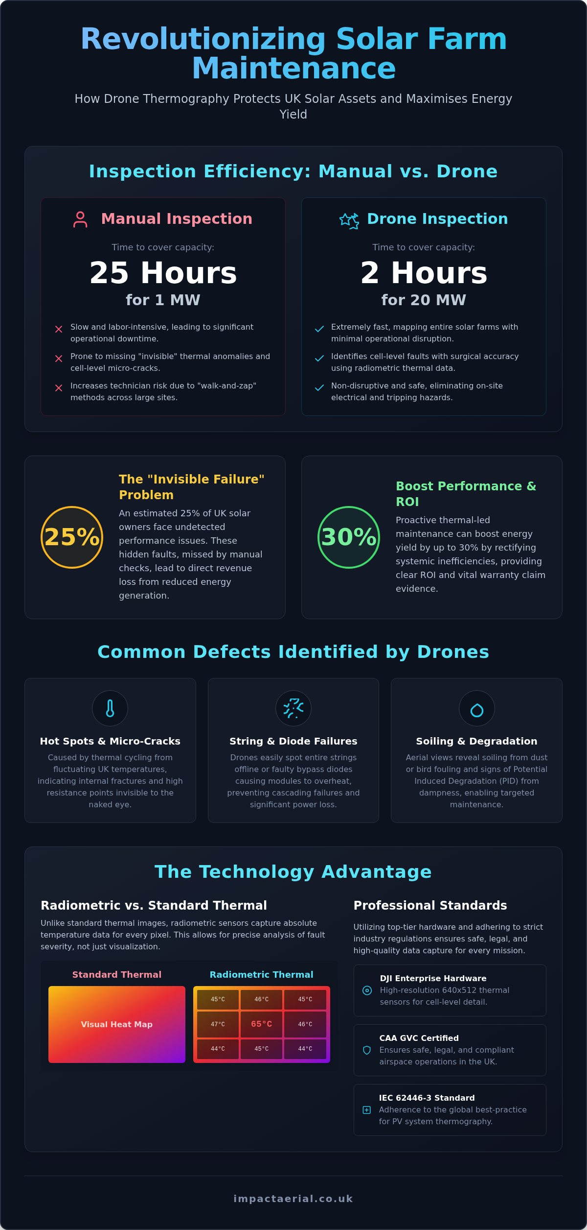
A single technician performing a manual inspection can take up to 25 hours to cover just one megawatt of solar capacity, yet a professional drone can survey 20 megawatts in as little as two hours. For UK solar farm operators, this isn’t just about speed; it’s about the financial risk of undetected string failures and the high cost of traditional “walk-and-zap” methods. You understand that maintaining peak efficiency is essential, but manual checks often leave your investment vulnerable to hidden defects and insurance non-compliance.
Choosing a professional solar panel drone inspection uk service provides the technical precision needed to protect your assets and maximise energy yield. By leveraging DJI Enterprise hardware and CAA GVC certified expertise, you can identify cell-level faults that are invisible to the naked eye. This guide details how drone thermography identifies defects with surgical accuracy, protects your revenue, and ensures a safe, non-disruptive inspection process. We’ll examine the 2026 regulatory requirements, the importance of the IEC 62446-3 standard, and how high-resolution data translates into a clear, actionable report for your maintenance team.
Key Takeaways
- Learn how radiometric thermal sensors pinpoint “invisible failures” and electrical resistance that manual checks often miss.
- Discover why a professional solar panel drone inspection uk can map a 5MW farm in hours, significantly reducing technician risk and operational downtime.
- Understand the essential pre-flight documentation and CAA airspace compliance needed to ensure a safe, legal, and non-disruptive aerial survey.
- See how high-resolution data capture and post-production reporting provide the precise evidence required for manufacturer warranty claims and insurance audits.
- Explore how central UK deployment and specialist DJI Enterprise hardware guarantee rapid, high-tier technical surveying for national solar assets.
Why Solar Panel Drone Inspections are Essential for UK Asset Managers
Asset management in the UK solar sector has moved beyond simple visual checks. A professional solar panel drone inspection uk utilizes Unmanned Aerial Vehicles (UAVs) equipped with high-resolution radiometric thermal sensors to map the health of photovoltaic (PV) assets. Unlike standard photography, these sensors capture temperature data for every single pixel. This allows technicians to see electrical resistance and thermal anomalies that are invisible to the naked eye. This transition to data-centric monitoring is no longer optional; it’s a financial necessity for protecting large-scale investments.
The “Invisible Failure” problem is a significant threat to UK solar farms. It’s estimated that 25% of UK solar owners currently face undetected performance issues that skip past traditional manual inspections. When a string fails or a bypass diode malfunctions, the loss in kilowatt-hours translates directly to lost revenue. Relying on “walk-and-zap” methods is often too slow and misses the subtle heat signatures that indicate a failing component. By the time a manual crew finds a fault, months of peak generation may have already been lost.
The UK’s unique climate also plays a critical role in asset degradation. Coastal installations are constantly battered by corrosive salt spray, while rural sites deal with aggressive lichen growth and bird fouling. British dampness can lead to potential induced degradation (PID) and insulation faults that are difficult to pinpoint from the ground. The Science of Aerial Thermography allows asset managers to detect these environmental impacts early, ensuring that small issues don’t escalate into site-wide failures.
Common Defects Found in UK Solar Arrays
- Hot Spots and Micro-cracks: These are often caused by thermal cycling, where the UK’s fluctuating temperatures cause cells to expand and contract, leading to internal fractures.
- String and Diode Failures: Drones can identify entire strings that have dropped offline or faulty bypass diodes that are causing modules to overheat.
- Specific Soiling Patterns: Aerial views reveal how industrial soot or agricultural dust settles across an array, allowing for more targeted cleaning schedules.
The ROI of Proactive Aerial Thermography
Proactive inspections offer a clear path to increased energy output. Early detection doesn’t just prevent total module failure; it significantly reduces fire risks associated with electrical arcing. Having high-resolution thermal data provides the “burden of proof” required to support manufacturer warranty claims before they expire. Booking a regular solar panel drone inspection uk ensures your portfolio remains compliant and profitable. Some industry professionals report that thermal-led maintenance can lead to a performance boost of up to 30% by identifying and rectifying systemic inefficiencies that were previously hidden.
The Science of Aerial Thermography: How Thermal Drones Detect Defects
Thermal drones identify defects by detecting infrared radiation emitted by solar modules. When a cell or component develops high electrical resistance, it generates excess heat. This heat signature is captured by the drone’s sensor, allowing us to visualize faults that aren’t apparent in the visible spectrum. The Science of Aerial Thermography demonstrates that these temperature variations are direct indicators of electrical health. High-tier hardware, such as the DJI Enterprise series, provides the resolution needed to move beyond simply seeing a hot spot. With a 640×512 thermal sensor, we can identify specific faulty cells within a single module from a safe flight altitude, providing the granular detail necessary for precise maintenance.
Radiometric Data vs. Standard Thermal Imaging
Standard thermal imaging produces a visual map of heat, but it lacks the underlying data required for technical analysis. Radiometric thermography is the gold standard for PV inspections because it captures absolute temperature values for every single pixel in the image. This data allows asset managers to quantify the severity of a defect. If a cell is 20°C hotter than its neighbors, it indicates a far more critical failure than a 5°C variance. Our PV solar farm thermal surveys provide this level of quantitative detail, ensuring your maintenance reports are based on hard data rather than visual estimation.
Environmental Conditions for a Successful UK Survey
Precision in a solar panel drone inspection uk depends heavily on environmental variables. To achieve valid thermal contrast, the IEC 62446-3 standard requires a minimum irradiance of 600 W/m². We typically aim for “solar noon” to ensure the sun is at its highest point, minimizing shadows and maximizing thermal signatures.
- Irradiance Levels: High solar radiation is essential to create the thermal “stress” required to reveal defects.
- Wind Speeds: We monitor wind carefully, as high speeds can cause convective cooling that masks heat signatures.
- Cloud Cover: Consistent sky conditions are vital. Intermittent clouds cause fluctuating irradiance, which can lead to false positives.
- Emissivity and Angles: We adjust for how different glass materials reflect heat to ensure the sensor captures true temperature values.
Managing the British weather window is a meticulous process. We don’t just fly when it’s sunny; we fly when the atmospheric conditions meet the strict technical criteria for data integrity. This ensures that every report we deliver is both accurate and legally compliant for insurance or warranty purposes.
Drone Surveys vs. Manual Inspections: A Cost and Safety Comparison
Traditional manual inspections are increasingly viewed as a legacy approach that introduces unnecessary risk and expense. When you commission a solar panel drone inspection uk, you’re replacing a slow, subjective process with a high-speed, data-driven methodology. Research indicates that a manual technician can take up to 25 hours to inspect a single megawatt of capacity. In contrast, a professional drone crew can cover 20 megawatts in just two to four hours. This isn’t just a marginal gain; it’s a fundamental shift in how UK asset managers maintain portfolio health.
Speed and Efficiency on Large-Scale PV Farms
Automated flight paths ensure that every asset is captured with 100% coverage, leaving no gaps in the data. Unlike manual crews who may miss modules due to fatigue or difficult terrain, a drone follows a precise GPS-guided grid. This efficiency allows for inspections that don’t require system shutdowns, ensuring your farm continues to generate revenue while the survey is underway. For a 10-hectare site, the timeline moves from several days of ground-based labor to a single afternoon of aerial data collection. This rapid turnaround is essential for catching faults during the specific “weather windows” required for valid thermal contrast.
Safety Standards and Insurance Compliance
Safety is the most compelling reason to transition away from manual “walk-and-zap” inspections. For commercial rooftop solar, drones completely eliminate “working at height” risks. There’s no longer a need for technicians to navigate fragile roof structures or carry heavy equipment across steep pitches. Utilizing a professional drone survey also provides a robust digital trail for commercial insurance audits. Our CAA GVC certified pilots operate under strict safety protocols, backed by £5m commercial liability insurance, which offers the level of reassurance that major UK insurers now demand.
Handheld thermography is often hindered by the “human error” factor. A technician on the ground may struggle to maintain the correct viewing angle or distance, leading to inconsistent data. Drones maintain a consistent altitude and angle of incidence, producing objective, repeatable results. This consistency is vital when comparing year-on-year degradation. By choosing a solar panel drone inspection uk, you’re investing in a safer, more reliable, and significantly more cost-effective asset health check that satisfies both internal safety boards and external stakeholders.
Planning Your Solar Inspection: Best Practices for UK Site Managers
Successful execution of a solar panel drone inspection uk begins long before the aircraft arrives on site. For asset managers, the preparation phase is critical to ensure data integrity and operational safety. A professional drone team requires a comprehensive pre-flight information pack, including high-resolution site maps, total MWp capacity, and precise inverter locations. This allows the pilot to program autonomous flight paths that guarantee 100% asset coverage. In the UK’s complex airspace, we also conduct thorough checks for NOTAMs (Notice to Airmen) and Flight Restriction Zones (FRZs), particularly for assets located near airports or military installations.
Industry standards for 2026 have solidified around the annual “health check” model. Conducting a full thermal survey once a year ensures that your asset remains compliant with insurance requirements and manufacturer warranty terms. This regular cadence allows for trend analysis, where year-on-year degradation can be measured with scientific precision. If you’re managing a portfolio across England or Wales, our Birmingham hub provides a central base for rapid deployment to ensure these annual windows aren’t missed due to the unpredictable British weather.
Understanding the Deliverables and Data Integration
The output of a modern survey is far more than just a collection of images. We provide a hierarchy of deliverables designed for different stakeholders. This includes high-resolution orthomosaic maps, which act as a “digital twin” of the entire array. Every detected anomaly is tagged and categorized by severity, from minor cell-level hotspots to critical string failures. By utilizing a high-specification survey drone, we produce data that integrates seamlessly into your existing GIS platforms or asset management software, allowing your maintenance teams to navigate directly to faulty modules using GPS coordinates.
Regulatory Compliance in the UK
Compliance is the cornerstone of professional aerial surveying. It’s a legal requirement that any pilot conducting commercial work in the UK holds a valid drone license, specifically the CAA GVC (General Visual Line of Sight Certificate). Beyond flight permissions, site managers must ensure that the drone operator provides site-specific Risk Assessments and Method Statements (RAMS) that account for the unique hazards of an industrial environment. We also prioritize GDPR and privacy compliance, ensuring that data capture is strictly limited to the site boundaries, which is especially vital for rooftop solar in residential or public-facing areas.
Ensuring your site meets these rigorous standards protects your business from liability and ensures the resulting data is legally defensible. If you’re ready to schedule your annual health check, contact us for a professional PV solar farm thermal survey tailored to your specific site requirements.
Maximising PV ROI with Impact Aerial’s Specialist Drone Surveys
Securing a high return on investment for solar assets requires more than just identifying faults; it requires a partner who understands the operational nuances of the UK energy sector. At Impact Aerial, we bridge the gap between technical data collection and actionable maintenance reporting. While our sensors capture cinematic-grade detail, our primary focus remains the technical accuracy required for a solar panel drone inspection uk. Our Birmingham headquarters serves as a strategic central hub, allowing our teams to deploy rapidly to solar assets across England and Wales as soon as an optimal weather window opens.
Safety and compliance aren’t just checkboxes for our operation; they’re the foundation of our service. Operating with £5m commercial liability insurance and full CAA GVC certification provides the reassurance and tangible legal protection that asset managers require. We understand that large-scale PV farms are high-value industrial environments where a “zero-incident” approach is non-negotiable. This meticulousness extends to our post-production phase, where raw thermal data is transformed into prioritized maintenance reports.
Expertise You Can Trust
We utilize DJI Enterprise hardware specifically for its mission-critical reliability and high-resolution thermal capabilities. This technology, combined with our extensive experience across the construction and property sectors, allows us to navigate complex industrial sites with precision. Our professional drone services are designed to move from data collection to decision-making as efficiently as possible. We don’t just deliver a folder of images; we deliver a prioritized list of defects that empowers O&M teams to act immediately, restoring lost yield and protecting long-term revenue.
- Strategic Deployment: Rapid response from our Birmingham base to sites across the UK.
- Technical Precision: Utilizing radiometric sensors for cell-level fault identification.
- Full Compliance: CAA GVC certified pilots and £5m commercial liability insurance.
- Actionable Reporting: Data formatted for immediate integration into asset management platforms.
Request Your 2026 Solar Health Audit
Every solar portfolio has unique technical requirements, whether you’re managing a single commercial rooftop or a multi-site ground-mount array. Our consultation process begins by matching our sensor payloads to your specific data needs, ensuring the resulting report meets the exact standards of your insurance provider or manufacturer warranty terms. By choosing a specialist solar panel drone inspection uk, you’re investing in the long-term health and efficiency of your renewable energy assets.
Don’t let undetected string failures or micro-cracks erode your generation revenue. Secure your asset’s future by partnering with a technologically adept surveying team. Contact us today to receive a tailored quote for your solar health audit and discover how professional drone thermography can transform your maintenance strategy.
Securing Peak Performance for Your Solar Portfolio
As the UK solar market matures, the transition to aerial thermography has become a fundamental requirement for efficient asset management. A professional solar panel drone inspection uk offers the speed and technical depth necessary to pinpoint cell-level defects that manual teams simply cannot detect. This data-centric approach doesn’t just improve safety; it directly protects your bottom line by identifying revenue-draining failures before they escalate into critical system shutdowns.
Impact Aerial brings together CAA GVC Certified Pilots and specialist DJI Enterprise thermal hardware to ensure every survey meets the highest industry standards. Backed by £5m commercial liability insurance, we offer the reassurance that your high-value assets are in expert hands. We’re ready to help you move from reactive maintenance to a proactive, data-driven strategy that guarantees peak performance across your entire portfolio.
Book your professional UK solar panel drone inspection with Impact Aerial today and secure the future of your energy investment.
Frequently Asked Questions
How often should solar panels be inspected by a drone in the UK?
Annual health checks are the recommended industry standard for 2026. Regular 12-month intervals allow asset managers to track degradation trends and provide the necessary documentation for manufacturer warranty claims. This cadence ensures that minor cell defects don’t escalate into site-wide string failures, maintaining consistent energy output throughout the lifecycle of the array.
Can a drone detect a single faulty cell in a large solar farm?
Yes, high-resolution radiometric sensors can identify a single faulty cell within a large-scale array. By utilizing hardware with a minimum thermal resolution of 640×512 pixels, pilots can pinpoint individual hotspots and micro-cracks from a safe flight altitude. This granular level of detail is essential for precise maintenance, allowing O&M teams to navigate directly to the specific module requiring repair.
What weather conditions are required for a thermal solar survey?
Valid thermal data requires a minimum irradiance of 600 W/m² to create sufficient thermal contrast. Surveys should be conducted during “solar noon” with clear skies or consistent cloud cover to avoid false positives caused by fluctuating light. Wind speeds must remain low to prevent convective cooling from masking heat signatures, while rain or high humidity will invalidate the radiometric readings.
Is a drone solar inspection cheaper than a manual inspection?
Drone inspections are significantly more cost-effective than manual methods, primarily due to the massive reduction in labor hours. While a manual crew might take 25 hours to inspect a single megawatt, a drone can cover 20 megawatts in under four hours. This speed reduces site downtime and eliminates the expensive safety equipment and insurance premiums associated with technicians working at height.
Do I need to shut down my solar farm during the drone flight?
No, the solar farm must remain fully operational during the flight. For a solar panel drone inspection uk to be effective, the panels need to be under electrical load to generate the heat signatures that indicate resistance or failure. Shutting down the system would cool the components, making it impossible for the thermal sensors to detect anomalies or faulty cells within the strings.
What qualifications should a drone pilot have for solar inspections?
For commercial solar surveys in the UK, the pilot must hold a General Visual Line of Sight Certificate (GVC) issued by the Civil Aviation Authority. This qualification demonstrates the pilot’s competency in managing complex flights in the “Specific Category.” Additionally, operators should carry specialist commercial drone insurance, with a minimum of £5m public liability coverage being the standard for industrial site access.
How long does it take to receive the final thermal inspection report?
The turnaround time for a final thermal inspection report typically ranges from three to five working days, depending on the site’s total capacity. This period allows for the rigorous post-production phase, where raw radiometric data is processed into high-resolution orthomosaic maps and annotated PDF reports. Large-scale portfolios may require additional time for AI-assisted anomaly tagging and severity categorization.
Can drones inspect both rooftop and ground-mounted solar panels?
Drones are highly versatile and can inspect both large-scale ground-mounted solar farms and complex commercial rooftop arrays. Aerial surveys are particularly beneficial for rooftops as they eliminate the need for scaffolding or fragile roof access, reducing safety risks for personnel. Whether the asset is a sprawling rural site or an industrial warehouse roof, the solar panel drone inspection uk process provides total coverage without the logistical challenges of ground-based surveying.
 2 Norton Drive, Wythall, Birmingham, B47 6HH Company registration number: 11138586. VAT Number: 366 9068 55


