
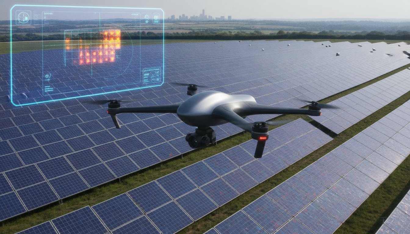
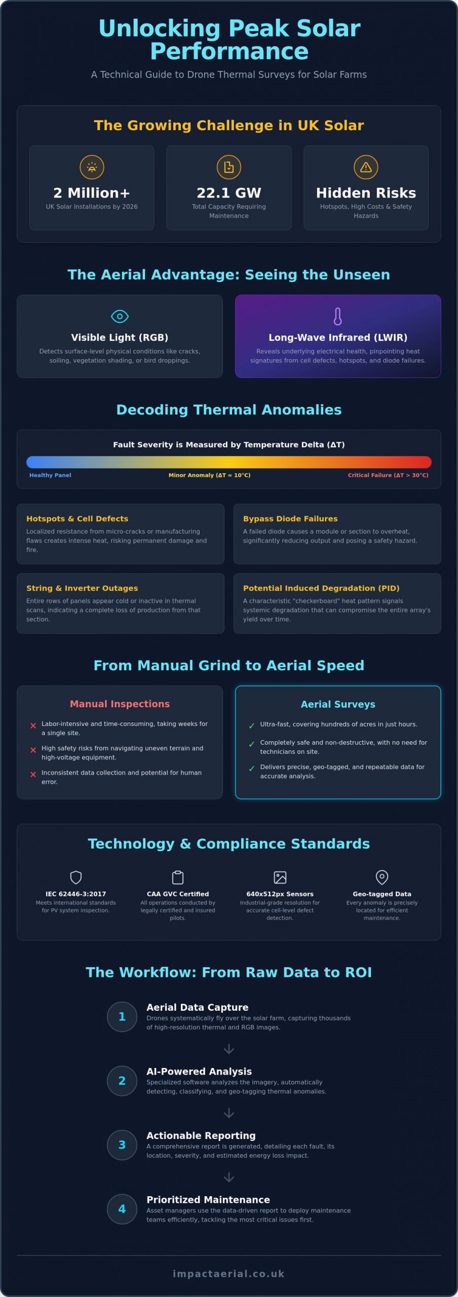
With the UK surpassing 2 million solar installations in early 2026, the challenge of maintaining peak efficiency across 22.1 GW of capacity has reached a critical tipping point. You likely recognize the frustration of watching energy yields decline due to unidentified hotspots, while the high cost and safety risks of manual IV curve testing make traditional inspections feel like a liability. Relying on inconsistent reporting from previous providers only adds to the uncertainty of your asset’s long-term health. A professional drone thermal survey for solar farms changes this dynamic by converting raw aerial data into a prioritized maintenance roadmap.
This guide explores how advanced thermography identifies critical faults with precision, ensuring you meet the internationally recognized IEC 62446-3:2017 standards for safety and performance. You’ll discover how to leverage AI-powered analysis to increase energy output and extend the longevity of your PV assets. We will cover everything from the latest 2026 CAA regulatory requirements to the specific hardware and software that turn complex thermal imagery into actionable ROI. By the end of this article, you’ll understand how to transition from reactive repairs to a meticulous, data-driven strategy that guarantees your solar farm remains a high-performing, compliant asset.
Key Takeaways
- Distinguish between visible light and long-wave infrared data to pinpoint thermal anomalies that are invisible to the naked eye.
- Identify specific cell-level defects, such as hotspots and bypass diode failures, alongside broader string and inverter outages.
- Understand why commissioning a professional drone thermal survey for solar farms requires CAA GVC certified pilots and industry-standard liability insurance.
- Learn how to translate raw aerial mapping data into actionable maintenance reports that prioritize repairs based on energy loss impact.
- Discover the precise workflow and specialist hardware needed to maximize the long-term ROI and operational safety of your PV assets.
What is a Drone Thermal Survey for Solar Farms?
A drone thermal survey for solar farms is a specialized diagnostic process that uses aerial platforms to capture high-resolution temperature data across photovoltaic installations. By integrating thermal sensors with advanced flight systems, operators can visualize heat signatures that remain invisible to the naked eye. This process relies on What is Thermography? to convert infrared radiation into a visual map of an asset’s thermal profile. Unlike standard photography, which uses visible light (RGB) to document physical surface conditions like cracks or bird droppings, long-wave infrared (LWIR) data capture identifies the underlying electrical health of individual cells and components.
For industrial compliance in 2026, professional surveys now mandate sensors with a minimum resolution of 640×512 pixels. This level of detail is necessary to distinguish between minor surface debris and genuine internal cell defects from a safe flight altitude. The drone acts as a stabilized, GPS-locked platform, ensuring that sensors are deployed at precise angles to maintain data consistency across thousands of panels. This meticulous approach ensures that every anomaly is geo-tagged for exact location identification during subsequent maintenance.
To better understand how these advanced systems operate in a real-world environment, watch this demonstration of high-speed aerial inspection:
The Shift from Manual to Aerial Inspections
Manual inspections, including handheld thermography and IV curve tracing, are increasingly seen as obsolete for utility-scale sites. These traditional methods are labor-intensive and often take weeks to complete for a single farm. In contrast, aerial surveys can cover hundreds of acres in a matter of hours. Beyond speed, the safety benefits are undeniable. Technicians no longer need to navigate uneven terrain or work in close proximity to high-voltage equipment, significantly reducing the risk of on-site accidents during routine maintenance audits.
How Thermal Sensors Detect Solar Inefficiency
The core physics of a thermal survey involve identifying where electrical energy is being converted into heat rather than current. When a solar cell or internal bypass diode fails, it creates resistance. This resistance generates a heat signature known as a hotspot. By measuring the “Delta T,” or the temperature difference between a fault and the surrounding healthy panels, specialists can categorize the severity of the issue. A drone thermal survey for solar farms serves as a non-destructive testing (NDT) method for verifying asset health without interrupting energy production.
Identifying Critical Faults: What Aerial Thermography Reveals
Thermal anomalies within a solar array are categorized by their temperature delta (Delta T) compared to the surrounding panel baseline. A temperature difference of 10°C might indicate a minor efficiency drop, while a Delta T exceeding 30°C often signals a critical failure requiring immediate intervention. This classification is vital for prioritizing maintenance. Without understanding the severity of these temperature variances, asset managers risk wasting resources on non-critical issues while ignoring potential fire hazards. A meticulous drone thermal survey for solar farms provides the granular data needed to make these distinctions with technical certainty.
Faults at the cell level, such as micro-cracks or manufacturing flaws, create localized resistance that manifests as heat. According to academic research on UAV thermal imaging, the precision of modern aerial sensors allows for the detection of these anomalies across massive arrays with high repeatability. Systemic issues like Potential Induced Degradation (PID) show up as a characteristic checkerboard pattern of heat across multiple modules, usually located near the negative pole of the string. Identifying these signatures early prevents the gradual degradation of the entire array’s energy yield.
Hotspots and Cell Failures
A single failing cell isn’t just a localized drop in production. It acts as a resistor, dissipating power from healthy cells as heat. If you leave these hotspots unaddressed, they can lead to backsheet browning or catastrophic fire risks. Distinguishing between temporary shading and permanent cell damage is a core part of professional diagnostic reporting. Precise thermal data identifies which modules are nearing the end of their functional life before they compromise the safety of the entire rack.
String Errors and Large-Scale Outages
When an entire string or row goes dark, the financial impact is immediate and significant. Aerial views are the only efficient way to visualize these large-scale patterns across thousands of panels simultaneously. A dead string often points to a blown fuse, a disconnected cable, or a faulty inverter. Detecting these outages early in a financial quarter can save thousands in lost energy production. Owners looking to secure their infrastructure should consider a professional PV solar farm thermal survey to ensure no string goes unmonitored and every fault is documented for rapid repair.
The UK Regulatory Landscape: Safety, Compliance, and Insurance
A professional drone thermal survey for solar farms requires more than high-end sensors; it demands a rigorous adherence to UK aviation law and electrical inspection standards. Operating on industrial sites involves managing risks associated with high-voltage equipment, public footpaths, and sensitive local infrastructure. To ensure data integrity and site safety, surveys must align with BS EN ISO 62446. This international standard governs the documentation and inspection of grid-connected photovoltaic systems, providing a legally defensible framework for warranty claims and safety audits. Meticulous compliance isn’t an optional extra; it’s the foundation of a reliable asset management strategy.
Risk mitigation begins long before the drone takes flight. Every project starts with a detailed pre-flight site assessment (PFSA) to identify local hazards, restricted airspaces, and ground-level obstacles. Emergency procedure protocols are established to manage potential equipment failures or unexpected site intrusions. This structured approach ensures that the survey process remains non-intrusive and safe, allowing the solar farm to continue generating power without interruption while the inspection is underway.
Why CAA GVC Certification is Non-Negotiable
The General Visual Line of Sight Certificate (GVC) is the mandatory qualification for pilots operating drones in the “Specific” category under Civil Aviation Authority (CAA) regulations. This certification proves that the pilot has undergone rigorous theoretical and practical testing to manage complex flight operations. Certified pilots are trained to handle airspace coordination and ground risk management, which is critical when flying near substations or residential boundaries. For a detailed breakdown of the latest requirements, you can read our UK Drone License: A Simple Guide to CAA Rules in 2026. Choosing an uncertified operator doesn’t just risk a fine; it potentially invalidates your site’s operational insurance.
Insurance and Liability for Solar Asset Managers
Hobbyist drone insurance is entirely insufficient for commercial solar environments. Professional surveys require specialist commercial-grade liability insurance that specifically covers aerial work and professional indemnity. While some providers offer lower tiers of coverage, £5m commercial liability insurance is the recognized industry standard for accessing utility-scale solar farms. Impact Aerial maintains a minimum of £5m liability for every project to provide total reassurance to asset managers. This coverage protects the client against third-party claims, accidental equipment damage, and business interruption, ensuring that your investment is fully protected from the moment our team arrives on site.
The Workflow: From Raw Data to Actionable Maintenance Reports
Executing a successful drone thermal survey for solar farms depends on a structured, multi-stage workflow. It isn’t just about flying; it’s about capturing data that is technically valid and legally defensible. The process begins with meticulous planning to align flight schedules with precise meteorological windows. Without the correct environmental variables, the resulting thermal imagery can produce false negatives, leading to missed faults and continued energy loss. This systematic approach ensures that every flight delivers a high-tier data set suitable for long-term asset optimization.
Optimal Conditions for Thermal Accuracy
For a survey to meet international standards like IEC TS 62446-3:2017, solar irradiance must be at least 600W/m². This level of sunlight ensures that the panels are operating at a sufficient capacity to generate detectable heat signatures from internal resistance. In the UK, managing this “window of opportunity” requires constant monitoring of cloud-free intervals. Cloud shadows create thermal noise that obscures genuine defects. Additionally, wind speeds must remain below certain thresholds. High winds cause convective cooling on the panel surface; this can mask subtle hotspots and skew the Delta T measurements required for fault classification.
Data Processing and Post-Production
Once the on-site data capture is complete, the raw thermal video and thousands of individual orthomosaic images move into post-production. This stage uses high-end analytic software to stitch the data into a single, geo-referenced map of the entire site. While AI-powered tools are excellent for the initial detection of anomalies, they aren’t infallible. Meticulous manual verification by a qualified thermographer is essential to filter out false positives caused by reflections or surface debris. This human oversight ensures that the maintenance team only receives accurate, verified data rather than raw, unrefined algorithmic guesses.
This level of technical precision is a hallmark of high-tier operations. You can learn more about how these processes integrate into broader industrial needs in our A Complete Guide to Professional Drone Services in the UK.
The final output is a comprehensive report featuring a “Red, Amber, Green” (RAG) severity rating system. Every identified fault is geotagged with sub-meter accuracy, allowing ground teams to navigate directly to the specific module requiring repair. This prioritized roadmap converts complex aerial data into a clear plan for asset optimization. If you are ready to secure your site’s energy output, book a professional drone thermal survey for solar farms today.
Maximising Solar Farm ROI with Impact Aerial
Maximising the return on investment for a utility-scale solar asset requires a shift from viewing maintenance as a cost to seeing it as a performance driver. A professional drone thermal survey for solar farms provides the empirical evidence needed to eliminate energy leakage. By identifying underperforming strings and faulty modules, asset managers can recover lost generation capacity that would otherwise remain hidden for years. Impact Aerial facilitates this transition by providing high-fidelity data that bridges the gap between aerial observation and electrical rectification. Our Birmingham-based team serves the entire UK renewable sector, ensuring that distance is never a barrier to high-tier technical surveying.
Our commitment to precision is supported by the use of DJI Enterprise drones, which are the industry standard for industrial-grade data capture. These platforms allow us to deploy high-resolution thermal and RGB sensors simultaneously, providing a dual-layered view of asset health. This hardware ensures that every pixel of data is geo-referenced and technically accurate, meeting the stringent requirements of O&M teams who need to execute immediate, targeted repairs. We don’t just provide images; we deliver a bespoke reporting suite tailored to the specific operational needs of your site technicians.
The Financial Case for Annual Thermal Audits
Annual audits are essential for maintaining the long-term viability of a solar portfolio. These surveys allow asset managers to support warranty claims against panel manufacturers by providing undeniable proof of manufacturing defects or premature cell degradation. It’s much easier to secure a replacement module when you have a geo-tagged thermal report showing a clear bypass diode failure. Impact Aerial provides the technical data needed for insurance and warranty validation. By moving to a proactive maintenance model, you can significantly reduce long-term O&M budgets and prevent minor faults from escalating into costly, large-scale outages.
Why Partner with Impact Aerial?
Choosing a survey partner is a matter of trust, compliance, and technical capability. Impact Aerial is defined by a meticulous approach to every project, from the initial pre-flight assessment to the final data delivery. Our credentials provide total reassurance for site owners and managers. We operate with full CAA GVC certification and maintain £5m in commercial liability insurance as standard. This professional foundation, combined with our high-spec hardware and data-centric processes, makes us a trusted specialist for the UK’s leading renewable energy firms.
If you’re looking to secure the longevity and output of your PV assets, the next step is a technical consultation. We can review your solar portfolio and design a survey schedule that aligns with your maintenance windows and regulatory obligations. To discuss your requirements and request a detailed proposal, contact the Impact Aerial team today.
Secure the Future of Your Solar Portfolio
Ensuring site safety and regulatory compliance is central to our process. Our team of CAA GVC Certified Pilots works within a framework of £5m Commercial Liability Insurance, providing total reassurance for every project. Combined with our expert post-production data analysis, we deliver the technical precision required for both warranty validation and operational excellence. It’s time to take control of your asset health with a partner dedicated to technical surveying standards.
If you’re ready to optimize your energy yield and extend the longevity of your installation, request a professional solar farm thermal survey quote from Impact Aerial today. We look forward to helping you maintain a high-performing and compliant solar portfolio.
Frequently Asked Questions
How often should a solar farm undergo a drone thermal survey?
Annual surveys are recommended to maintain a proactive maintenance schedule. This frequency allows asset managers to track degradation over time and catch bypass diode failures before they cause significant energy loss. Regular inspections also ensure that your site remains compliant with insurance requirements and safety standards.
What is the best time of year to conduct a thermal solar inspection in the UK?
The optimal window for a drone thermal survey for solar farms in the UK is between April and September. During these months, the sun is high enough in the sky to provide the necessary irradiance levels for accurate data. Clear, blue-sky days with low wind speeds are ideal to avoid thermal cooling or cloud reflections that can obscure faults.
Can a drone survey detect micro-cracks in solar panels?
Aerial thermography detects micro-cracks by identifying the localized heat they generate. While the crack itself might be microscopic, the resulting electrical resistance creates a distinct thermal signature. Using industrial-grade 640×512 sensors ensures these anomalies are captured clearly even from a standard flight altitude.
How long does it take to receive the final thermal report after the flight?
You can typically expect to receive a comprehensive, actionable report within five to ten working days after the data capture is complete. This timeline accounts for the meticulous post-production process. Our experts manually verify AI detections to ensure every identified fault in the RAG-rated report is accurate and ready for your O&M team.
Do I need to shut down the solar farm during the drone survey?
There is no need to shut down your site during the inspection process. In fact, the solar farm must be fully operational and under load for the thermal sensors to detect anomalies. This non-intrusive method allows you to maintain peak energy production while we conduct our safety and performance audit.
What is the minimum irradiance required for an accurate thermal reading?
An irradiance level of at least 600W/m² is required to ensure valid thermal data. This threshold is set by international standards to guarantee that panels are under enough electrical stress to reveal internal defects. We monitor local weather and irradiance levels constantly to ensure every flight occurs within these specific technical parameters.
Are drone thermal surveys accepted for manufacturer warranty claims?
Major panel manufacturers increasingly accept high-quality drone thermal data as evidence for warranty claims. To be valid, the survey must follow recognized standards like IEC 62446-3 and provide geo-tagged, high-resolution imagery. Our meticulous reporting provides the technical proof needed to hold manufacturers accountable for component failures.
How does the cost of a drone survey compare to manual panel testing?
A professional drone thermal survey for solar farms offers a significant cost advantage over manual IV curve tracing on utility-scale sites. While manual testing is labor-intensive and covers only a fraction of the panels, a drone captures data for 100% of the asset in a fraction of the time. This efficiency reduces total O&M expenditure while providing a more complete picture of site health.
 2 Norton Drive, Wythall, Birmingham, B47 6HH Company registration number: 11138586. VAT Number: 366 9068 55


