
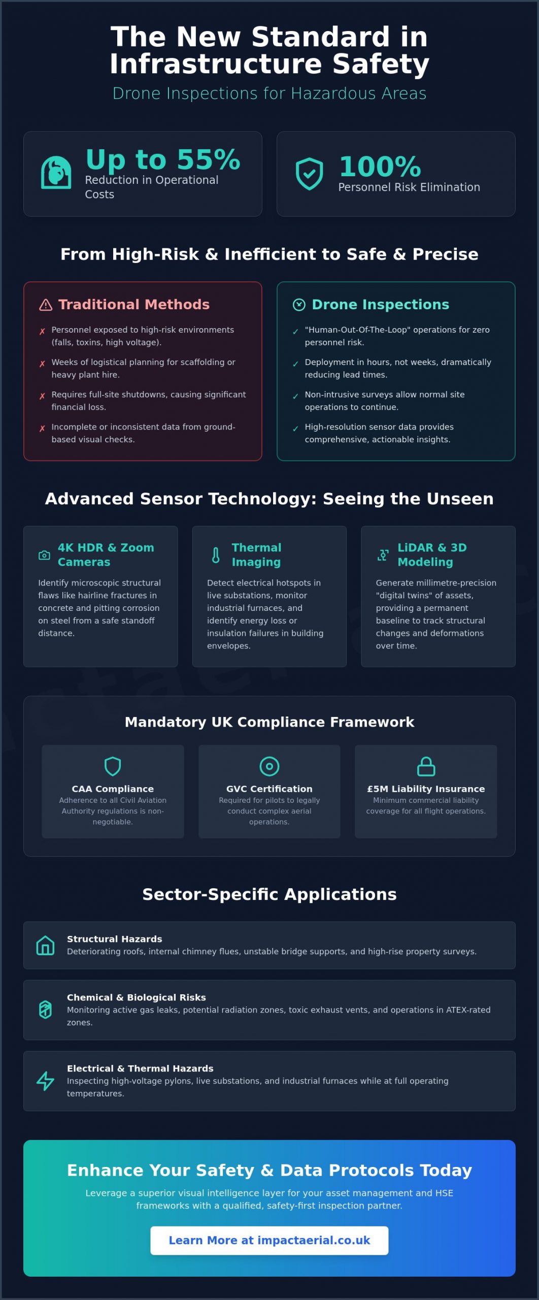
Did you know that integrating specialized UAV technology into infrastructure surveys can reduce operational costs by as much as 55% while completely removing personnel from high-risk environments? For asset managers and safety officers, the liability of sending a team into a confined space or onto high-altitude scaffolding is a constant pressure on both the budget and the conscience. You’re likely familiar with the logistical delays of traditional access and the frustration of receiving incomplete data from ground-based inspections.
This professional guide explores how a drone inspection for hazardous areas acts as a superior visual intelligence layer, not just a safety alternative. You’ll learn how to leverage advanced sensors like LiDAR and thermal imaging to gain precision insights that were previously unreachable. We’ll also break down the critical 2026 regulatory landscape, including mandatory GVC certifications and the new UK-specific drone classifications. By the end of this article, you’ll have a clear framework for choosing a qualified inspection partner who prioritizes meticulous compliance and high-tier data delivery.
Key Takeaways
- Understand how “Human-Out-Of-The-Loop” operations eliminate personnel risk in ATEX zones and high-voltage environments.
- Learn how 4K HDR and thermal sensors identify microscopic structural defects and electrical hotspots that ground-based teams might miss.
- Verify the latest 2026 CAA compliance requirements, including the necessity of GVC certification and £5 million commercial liability insurance.
- Discover why a professional drone inspection for hazardous areas is now the industry standard for safe construction monitoring and high-rise property surveys.
- Gain a framework for integrating UAV data into your existing HSE protocols through a structured consultation and safety-first flight planning process.
Why Drone Inspection for Hazardous Areas is the New Industry Standard
A professional drone inspection for hazardous areas is the deployment of specialized Unmanned Aerial Vehicles (UAVs) to survey, map, and analyze high-risk industrial zones. This technology has shifted from a niche alternative to a primary requirement for asset managers who prioritize safety and data precision. By implementing a “Human-Out-Of-The-Loop” strategy, organizations can conduct detailed visual assessments in ATEX-rated zones and high-voltage environments without ever placing a technician in harm’s way.
Global Drone Regulations have matured alongside these hardware advancements, providing a legal framework that supports complex aerial operations in sensitive locations. This regulatory clarity allows businesses to replace traditional, high-risk access methods with a process that is both faster and more reliable.
To better understand how these specialized units operate in challenging environments, watch this helpful video:
The speed of deployment is perhaps the most immediate advantage. Traditional inspections often require weeks of logistical planning, scaffolding erection, or the hire of heavy plant equipment like cherry pickers. A professional UAV team can often be site-ready and airborne within hours. This agility directly impacts site downtime. Because aerial methods are non-intrusive, many industrial facilities can continue their standard operations while the inspection is underway, avoiding the massive financial losses associated with full-site shutdowns.
Defining Hazardous Environments for UAV Operations
Modern drone inspection for hazardous areas covers a broad spectrum of risks that would otherwise require intensive safety protocols for human entry. These include:
- Structural hazards: Surveying deteriorating roofs, internal chimney flues, and unstable bridge supports.
- Chemical and biological risks: Monitoring active gas leaks, potential radiation zones, and toxic exhaust vents.
- Electrical and thermal hazards: Inspecting high-voltage pylons, live substations, and industrial furnaces while they remain at operating temperatures.
The Economic Case: ROI Beyond Safety
Utilizing UAVs provides a significant return on investment by eliminating the recurring costs of heavy plant hire and the extensive labor hours required for manual access. Beyond the immediate savings, proactive hazard identification can lead to reduced insurance premiums, as it proves a commitment to rigorous maintenance and risk management. Additionally, the data collected can be used to generate “digital twins.” These 3D models serve as a permanent baseline for long-term asset management, allowing your team to track structural changes with millimetre precision over several years.
Advanced Sensor Technology: Capturing High-Resolution Data in Extreme Conditions
Successful drone inspection for hazardous areas relies on more than just flight stability. It requires a sophisticated sensor suite capable of capturing granular detail from a safe distance. High-resolution 4K HDR cameras are now the essential standard for identifying microscopic structural flaws. These sensors allow engineers to spot hairline fractures in concrete or the earliest stages of pitting corrosion on steel surfaces that are otherwise inaccessible. When combined with high-powered zoom lenses, pilots can maintain significant standoff distances. This capability reduces the risk of electromagnetic interference or physical collision while still delivering the visual clarity required for technical sign-offs.
The transition from raw imagery to actionable intelligence is where professional UAV operations provide the most value. A National Safety Council report on drone safety highlights that the ability to conduct these assessments remotely is a primary driver in reducing workplace fatalities. Raw data isn’t enough; it’s the readability that counts. Professional post-production processes ensure that technical metadata is overlaid correctly, making complex data sets accessible for stakeholders who weren’t on-site during the flight.
Visual Precision with DJI Enterprise Hardware
Commercial-grade hardware is a non-negotiable requirement for industrial environments. Platforms like the DJI Mavic 3 Enterprise are specifically engineered for these heavy-duty tasks. Unlike consumer models, these units feature mechanical shutters. This is a critical technical detail; it eliminates rolling shutter distortion, ensuring every frame is blur-free even when the aircraft is moving at speed. For a deeper look at the technical specifications of these aircraft, you can explore our survey drone guide, which details how specific hardware choices impact data quality.
Thermal and Multi-Spectral Analysis
Visual light is only one part of the spectrum used during a drone inspection for hazardous areas. Radiometric thermal sensors are essential for detecting sub-surface defects, such as insulation breaches or electrical hotspots in live substations. This technology is particularly transformative for renewable energy assets. Our specialized PV solar farm thermal surveys use these sensors to identify individual cell failures across thousands of panels in minutes. By converting raw thermal data into detailed engineering reports, asset managers can prioritize maintenance based on actual heat signatures. If you’re ready to enhance your safety protocols, our team offers the expert aerial surveying needed to secure your high-risk sites.
Navigating UK Regulations: CAA Compliance and Risk Mitigation
Operating a drone inspection for hazardous areas in the UK isn’t just about technical skill; it’s a strictly regulated legal activity. The Civil Aviation Authority (CAA) oversees all commercial UAV operations, requiring pilots to adhere to rigorous safety standards that protect both the public and critical infrastructure. For high-risk industrial sites, the previous ‘Permission for Commercial Operation’ (PfCO) has transitioned into specific categories that demand higher levels of training and operational oversight. Every flight must be backed by a comprehensive Operations Manual. This document is a legal requirement that details how the pilot manages high-risk flight profiles, equipment failure protocols, and emergency procedures specific to the aircraft being used.
The complexity of these missions is supported by a Systematic Review of Drone Sensors, which underscores the technical demands placed on hardware and operators in extreme conditions. This level of technical oversight ensures that data collection doesn’t compromise site safety, directly meeting the stringent requirements of UK aviation law. When you hire a professional team, you aren’t just paying for a flight; you’re investing in a legally compliant framework that mitigates liability.
The Importance of GVC Certified Pilots
Commercial industrial work requires a pilot who holds a CAA GVC certified status. This certification involves rigorous theoretical exams and practical flight assessments specifically designed for complex visual line of sight operations. These pilots don’t just fly; they conduct site-specific risk assessments and may operate under an Operating Safety Case (OSC) for missions that fall outside standard permissions. Certification is the primary differentiator between a hobbyist and a professional. It guarantees that the operator understands the legal and safety nuances of working around high-value assets, ensuring that every drone inspection for hazardous areas is conducted with meticulous precision.
Risk Management and Insurance
Standard business insurance policies rarely cover the complexities of industrial hazardous areas. In this sector, £5 million in commercial liability insurance is the industry minimum for professional UAV work. This coverage provides the necessary financial security for clients operating in high-value environments like refineries, chemical plants, or power stations. At Impact Aerial, we combine this high-level insurance with site-specific Risk Assessment Method Statements (RAMS) for every project. This meticulous approach ensures that our safety protocols integrate seamlessly with your own HSE requirements, providing psychological comfort and tangible protection. For more details on the current legislative environment, you can consult our UK drone license guide.
Sector-Specific Applications: Where UAVs Excel
While the technical specifications of modern aircraft are impressive, their true value is realized through sector-specific deployment. A drone inspection for hazardous areas provides a unique vantage point that ground-based teams simply cannot replicate safely. In 2026, research indicates that 67% of UK construction companies have adopted drone technology for site surveying and monitoring, moving away from expensive and slow manual methods. This adoption is driven by the need for real-time data in high-risk zones where heavy machinery and unstable ground make human entry a significant liability. The versatility of these systems allows them to excel in several key areas:
- Construction Site Monitoring: Tracking progress in areas with heavy machinery or unstable ground.
- Property and Roof Surveys: Inspecting high-rise structures without the need for rope access.
- Energy Infrastructure: Conducting preventative maintenance on pylons and solar farms.
- Industrial Chimneys and Flare Stacks: Visualizing internal and external integrity while the site remains live.
Construction and Civil Engineering
In the construction sector, UAVs serve as a continuous monitoring tool. They allow project managers to track progress across vast sites without halting work or risking personnel in active plant areas. Beyond simple monitoring, specialized drone property surveys are now standard for pre-acquisition reports on commercial real estate. These surveys provide an exhaustive visual record of an asset’s condition, from foundation stability to roof integrity. In hazardous environments like quarries, drones perform volumetric measurements of stockpiles with precision, keeping staff away from unstable slopes and heavy transport routes.
Renewable Energy and Utilities
The utility sector benefits from the speed of aerial surveys, particularly when managing sprawling assets like solar farms or national grid pylons. Inspecting hundreds of solar assets in a single flight is now a routine procedure, identifying faulty cells that would take days to find manually. For wind energy, UAVs detect bird strikes or lightning damage on turbine blades without requiring technicians to perform dangerous rope access maneuvers. Similarly, high-resolution photography is used for telecommunications mast inspections, allowing for the identification of loose fixings or weather damage from a safe standoff distance.
Industrial chimneys and flare stacks represent some of the most challenging environments for any surveyor. UAVs allow for the visualization of both internal and external integrity while these structures are live. This capability eliminates the need for costly shutdowns and the inherent risks of internal scaffolding. If your project requires high-resolution data in a high-risk environment, you can book a professional drone inspection today to secure your assets and ensure site safety compliance.
Implementing Drone Inspections with Impact Aerial
Integrating a drone inspection for hazardous areas into your operational workflow requires more than technical flight skills; it demands a seamless alignment with your existing site safety protocols. Precision doesn’t happen by accident. It’s the result of a structured, methodical approach that prioritizes regulatory compliance and technical excellence. A critical component of industrial safety is the integration with existing site management systems. We don’t just show up and fly; we ensure our operations are fully embedded within your “Permit to Work” (PTW) framework. This coordination ensures that aerial activity is synchronized with ground-based maintenance, preventing conflicting tasks and maintaining the integrity of the exclusion zone.
Our consultation process begins with a deep dive into your specific site hazards and data goals. Whether you’re managing a chemical plant or a high-rise construction site, we work alongside your HSE team to ensure every flight path is vetted and every risk is mitigated. Once the mission is complete, you receive high-tier data output, including 4K HDR video and ultra-high-resolution stills. For stakeholders who cannot be on-site, our post-production team can transform this data into immersive virtual tours, allowing for remote site visits and collaborative analysis from any location. For those managing mission-critical infrastructure from a central hub, you can discover Activu Corporation and their specialized visualization platforms for control rooms.
Our Professional Workflow
We follow a meticulous three-stage process to ensure 100% asset coverage and safety:
- Pre-flight planning: This involves detailed airspace checks, weather monitoring, and the preparation of site-specific Risk Assessment Method Statements (RAMS).
- On-site execution: Our pilots execute precise, repeatable flight patterns designed to capture every angle of the asset while maintaining safe standoff distances.
- Post-flight: Data is processed and delivered via secure cloud platforms, ensuring your engineering teams can access the information they need without delay.
Why Choose Impact Aerial?
Choosing the right partner for a drone inspection for hazardous areas is a decision rooted in trust and proven competence. Based in Birmingham, we provide a unique combination of local expertise and a comprehensive UK-wide reach. We don’t just claim to be professional; we back our operations with £5 million in commercial liability insurance and full CAA GVC certification. These aren’t just badges; they’re our commitment to your site’s security and the quality of the data we deliver. If you’re ready to eliminate human risk and gain superior visual intelligence for your high-risk assets, contact us today for a professional consultation and let our team help you secure your industrial future.
Securing Future-Proof Visual Intelligence for High-Risk Assets
The shift toward aerial surveying in industrial environments is a necessary evolution in workplace safety and operational efficiency. By removing personnel from dangerous zones and utilizing 4K HDR cinema-grade hardware, businesses can capture structural data with unprecedented clarity. Navigating the complex 2026 UK regulatory landscape requires a partner who understands the nuances of CAA compliance and rigorous risk mitigation. You’ve seen how these specialized UAVs transform data collection from a liability into a strategic advantage.
A professional drone inspection for hazardous areas ensures that your site remains operational while identifying critical defects that ground-based methods often miss. Impact Aerial provides the meticulous oversight needed for these high-stakes missions, backed by CAA GVC certified pilots and £5 million in commercial liability insurance. This combination of technical expertise and legal protection gives you the reassurance that your assets are in expert hands. It’s time to replace outdated access methods with precision aerial intelligence.
Ready to enhance your maintenance protocols? Request a Professional Drone Inspection Quote from Impact Aerial to secure the superior data your project deserves. We look forward to helping you achieve your safety and data goals.
Frequently Asked Questions
Is drone inspection safe for chemical plants or explosive atmospheres?
Yes, specialized UAVs are designed to operate safely in volatile environments without the risk of ignition. By utilizing a “Human-Out-Of-The-Loop” strategy, you eliminate the danger of sending personnel into potentially explosive or toxic zones. Our pilots use collision-tolerant hardware and follow strict safety protocols to ensure that every drone inspection for hazardous areas meets the highest industrial safety standards.
What kind of data do I receive after a hazardous area drone survey?
You receive a comprehensive package of high-resolution digital assets tailored to your engineering needs. This typically includes 4K HDR video and ultra-high-resolution still imagery for identifying structural defects. Depending on the mission, we also provide radiometric thermal maps to locate heat anomalies and 3D digital twins. These digital records allow your stakeholders to perform detailed analysis from a safe, remote office environment.
How long does a typical drone inspection take compared to traditional methods?
A drone survey is significantly faster, often completing in a single afternoon what would take days or weeks using scaffolding. Because there’s no need for complex assembly or heavy plant hire, the setup time is minimal. This speed doesn’t just save labor costs; it provides your team with rapid, actionable intelligence that allows for faster decision-making and maintenance scheduling.
Do I need to shut down my site during a drone inspection?
In most cases, site shutdowns are unnecessary because drone operations are non-intrusive. Unlike traditional methods that require large exclusion zones for scaffolding or cranes, a UAV can operate from a safe distance or overhead without interrupting your standard workflow. This ability to maintain production while conducting a drone inspection for hazardous areas is a major factor in reducing overall project costs.
What are the UK legal requirements for drone pilots in hazardous zones?
Commercial pilots must hold a valid General Visual Line of Sight Certificate (GVC) issued by the CAA. Additionally, the operator must possess a valid Operator ID and Flyer ID, alongside a minimum of £5 million in commercial liability insurance. These legal requirements ensure that the pilot is trained to handle complex flight profiles and manage site-specific risks according to the latest UK aviation standards.
Can drones operate in high-wind or poor weather conditions for inspections?
Professional enterprise drones are built with high IP ratings and wind resistance, allowing them to fly in light rain and winds up to 12 meters per second. While the hardware is robust, we prioritize data quality and safety. If weather conditions threaten to compromise the precision of the visual or thermal data, our pilots will reschedule the flight to ensure you receive the most accurate results possible.
How much does a professional drone inspection for hazardous areas cost?
Pricing is determined by the complexity of the site, the specific sensors required, and the level of risk involved. While basic surveys are more affordable, complex missions involving thermal imaging or confined spaces require specialized planning and hardware. We provide bespoke quotes based on your specific asset requirements, ensuring you receive a professional service that prioritizes both safety and high-end data delivery.
What is the maximum height a drone can reach for an industrial survey?
The standard legal height limit for drone operations in the UK is 400 feet (120 meters) above ground level. This is sufficient for the vast majority of industrial chimneys, flare stacks, and high-rise structures. For assets that exceed this height, we can apply for specific CAA permissions or an Operating Safety Case (OSC) to ensure the mission is conducted legally and safely within UK airspace.
 2 Norton Drive, Wythall, Birmingham, B47 6HH Company registration number: 11138586. VAT Number: 366 9068 55


