
Drone Survey for Property Portfolio Management: A Strategic Guide for UK Asset Managers

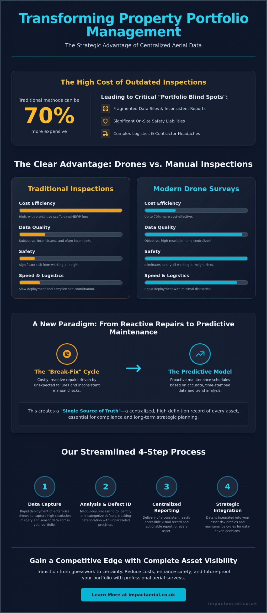
Did you know that traditional survey methods requiring scaffolding or mobile elevating work platforms can be up to 70% more expensive than modern aerial alternatives? For UK asset managers overseeing dozens of diverse sites, these manual inefficiencies don’t just drain maintenance budgets; they create fragmented data silos and significant safety liabilities. You’ve likely experienced the logistical headache of coordinating regional contractors and the frustration of receiving inconsistent reports that make long-term planning nearly impossible. Managing a complex estate requires a level of precision and oversight that manual inspections simply cannot deliver at scale.

Implementing a professional drone survey for property portfolio management allows you to transition from expensive reactive repairs to a streamlined, predictive maintenance model. You’ll discover how to transform multi-site oversight with data-driven surveys that reduce operational risk and provide a centralised, high-definition record of every asset. This guide explores the strategic integration of aerial data into your workflow, ensuring your portfolio remains compliant with evolving CAA regulations while significantly lowering your survey-related health and safety risks. We’ll examine how meticulous data capture and technical expertise provide the psychological comfort and tangible financial benefits your business requires.

Key Takeaways

  • Learn why traditional regional inspections create data silos and how a centralised aerial approach provides a consistent visual record across your entire estate.
  • Understand how enterprise-grade hardware and specialised sensors enable high-precision defect detection that manual site visits often miss.
  • Compare the significant time and cost advantages of rapid drone deployment versus the logistical complexity of scaffolding for multi-site inspections.
  • Discover a step-by-step framework for integrating a drone survey for property portfolio management into your existing asset risk profiles and lease cycles.
  • Explore how professional certification and centralised UK operations ensure consistent, compliant reporting that meets the highest safety and regulatory standards.

The Evolution of Property Portfolio Management: Why Drones are Essential

Property management has moved beyond simple facility maintenance into a complex era of asset lifecycle optimisation. A drone survey for property portfolio management represents a fundamental shift in how UK asset managers oversee large-scale estates, moving away from subjective manual checks toward objective, high-resolution digital data. By utilising advanced aerial survey technologies, managers can now obtain a comprehensive view of every asset, regardless of its location or height. This approach ensures that decision-making is rooted in technical precision rather than anecdotal evidence.

Many organisations suffer from what we call the “Portfolio Blind Spot.” This occurs when high-level financial data is disconnected from the actual physical condition of the buildings. Without a centralised visual record, asset managers often rely on disparate reports from various regional contractors, leading to inconsistent data and reactive, costly “break-fix” cycles. This lack of visibility often results in minor defects escalating into major capital expenditures because they weren’t identified during the early stages of deterioration.

To better understand how this technology is applied on-site, watch this helpful video demonstrating aerial data capture:

Modern compliance requirements, such as the Building Safety Act 2022, demand a “golden thread” of information that is transparent and easily accessible. Drones facilitate this by providing repeatable, time-stamped evidence of building integrity, which is essential for both ESG reporting and long-term safety audits. This transition to proactive maintenance helps preserve capital and ensures that high-value assets remain compliant with national standards. It’s about building a reliable database that supports both daily operations and long-term strategic goals.

The Limitations of Traditional Multi-Site Inspections

Traditional inspections often fail at scale due to the prohibitive costs of hiring scaffolding or mobile elevating work platforms for every site visit. When managing multiple properties across the UK, the logistical headache of coordinating these inspections is immense. Manual surveys are also inherently subjective; different surveyors may interpret the same defect in varied ways, creating a fragmented picture of the portfolio’s health. Working at height remains one of the primary safety liabilities for property owners, making traditional roof and facade inspections a significant risk factor that requires rigorous mitigation.

The Data-Centric Approach to Asset Oversight

Transitioning to a digital model allows stakeholders to access a “single source of truth” across the entire estate. High-resolution aerial data provides a meticulous visual history of every asset, allowing for side-by-side comparisons over several years to track deterioration rates accurately. This level of detail enables predictive maintenance schedules based on real-world evidence rather than guesswork or generic timelines. Drone surveys provide a non-intrusive method for gathering building data without tenant disruption, ensuring that business operations continue smoothly while critical inspections take place.

Key Drone Survey Technologies for Diverse Property Portfolios

Professional asset management requires more than just a standard camera in the sky. The effectiveness of a drone survey for property portfolio management depends heavily on the deployment of enterprise-grade hardware, such as the DJI Matrice or Mavic 3 Enterprise series. These platforms are designed for the rigours of commercial environments, offering the stability and flight endurance necessary to cover multi-acre industrial sites or complex retail parks in a single mobilisation. High-resolution 4K HDR imagery is the baseline requirement for dilapidation reports; it provides the clarity needed to identify hairline fractures in masonry or failing gutter seals that lower-tier equipment would simply overlook.

Precision is maintained through the use of RTK (Real-Time Kinematic) positioning and GPS-tagged data. This technology ensures that every captured image is georeferenced with centimetre-level accuracy, allowing managers to overlay aerial data onto existing site plans or GIS systems. All flight operations must be conducted by pilots who strictly follow UK drone safety regulations to ensure the legality and insurance validity of the data collected. Integrating these advanced sensors into your annual maintenance plan ensures a high-tier level of quality, which is why many asset managers opt for specialised drone commercial property surveys to secure their long-term data strategy.

Thermal Imaging for Energy Efficiency and Leak Detection

Radiometric thermal sensors are essential for identifying energy loss and sub-surface moisture across a portfolio. These cameras detect minute temperature variances, making them highly effective at spotting insulation gaps or water ingress on flat industrial roofs before leaks penetrate the building envelope. For portfolios with extensive solar PV arrays, thermal drones can rapidly identify malfunctioning cells that reduce energy yield. This data is invaluable for asset managers aiming to improve BREEAM ratings or EPC scores, as it provides documented evidence of thermal performance and targeted areas for remediation.

3D Modelling and Digital Twins for Asset Lifecycle Planning

Photogrammetry allows for the creation of high-fidelity 3D models and digital twins of every asset in a portfolio. By processing hundreds of overlapping aerial images, we generate accurate digital replicas that allow stakeholders to take precise measurements of facade areas or roof pitches from their desks. These models are particularly useful during tender processes for maintenance contracts; providing contractors with an accurate 3D model reduces the need for multiple site visits and ensures more competitive, accurate quotes. This digital record serves as a foundation for long-term lifecycle planning, ensuring that every repair is based on verified spatial data.
Drone Survey for Property Portfolio Management: A Strategic Guide for UK Asset Managers

ROI Analysis: Drone Surveys vs. Traditional Portfolio Inspections

The financial case for integrating a drone survey for property portfolio management becomes clear when you examine the logistical mobilisation required for traditional inspections. Compare the timeline for ten regional sites. Conventional methods often require multiple weeks of coordination, scaffolding permits, and physical site access that disrupts tenants. In contrast, a professional drone team can mobilise and complete the same ten surveys in a fraction of the time, often within a single week of favourable weather. Industry data suggests that drone mapping can be up to 400 times faster than traditional ground surveys, allowing asset managers to move from data collection to decision-making at an accelerated pace.

Cost savings are equally compelling. Professional drone surveys are typically 30% to 70% cheaper than traditional methods that require scaffolding or mobile elevating work platforms. These savings aren’t just limited to equipment hire. By identifying minor defects early, such as a slipped tile or a blocked parapet gutter, you prevent the type of large-scale water ingress that results in expensive capital expenditure and tenant compensation claims. A documented history of proactive maintenance can also lead to “hidden” savings, such as more favourable insurance premiums, as underwriters recognise the reduced risk profile of a well-monitored estate.

Manual surveying hours are often inflated by the sheer difficulty of accessing high-value commercial assets. Drones reduce these professional fees by providing surveyors with all the necessary visual data upfront. Instead of spending hours on a roof, a surveyor can review high-definition imagery from their office, focusing their expertise on analysis rather than the logistics of access. This efficiency ensures that your professional budget is spent on expert insight rather than site mobilisation.

Standardising Data Across a National Portfolio

Consistency is often the greatest challenge for managers overseeing assets from London to Birmingham. Using a single, specialised drone service provider ensures that every report follows the exact same technical standard and visual format. This comprehensive drone survey methodology serves as the baseline for all data collection across your estate. All reports are hosted in a centralised digital portal, providing stakeholders with instant access to the physical condition of any building in the portfolio without searching through disparate regional files.

Risk Mitigation and Health & Safety Compliance

The “Work at Height” regulations remain a primary concern for any property professional. Traditional manual surveys carry inherent safety liabilities that drones almost entirely eliminate. By keeping personnel on the ground, you remove the logistical and safety headaches associated with roof access. Drones eliminate the need for physical roof access, thereby removing the #1 cause of major workplace injuries in the sector. To ensure total portfolio-wide protection, we operate with £5m commercial liability insurance, providing you with the psychological comfort that all operations are fully covered and strictly compliant with national safety standards.

Implementing Drones into Your Property Management Strategy

Successful implementation of a drone survey for property portfolio management requires a shift in perspective. You shouldn’t view aerial inspections as isolated, one-off events. Instead, they must be integrated as a recurring data stream within your broader asset management framework. This starts with a clear operational plan that addresses scheduling, tenant liaison, and data integration. By establishing a standardised workflow, you ensure that the high-resolution data captured on-site translates directly into actionable maintenance tasks within your existing CAFM (Computer-Aided Facility Management) systems.

Scheduling should be driven by asset risk profiles rather than arbitrary dates. A warehouse roof in a coastal environment, for instance, may require a more frequent inspection cadence than a modern retail unit in a sheltered urban area. You should also align these surveys with lease cycles. Conducting an aerial audit six months before a lease expiry provides the documented evidence needed for accurate dilapidation claims. Privacy is paramount in urban environments. Asset managers must develop a clear communication plan for tenants, ensuring they are notified of flight times and the strict privacy protocols followed by the flight crew. Modern software allows for the automatic blurring of faces and sensitive information, maintaining compliance with UK data protection standards.

Step 1: Portfolio Audit and Priority Mapping

The first phase involves categorising your estate to identify high-priority assets. Focus on buildings with aging facades, complex roof structures, or known historical issues. By mapping these risks, you can set a logical inspection cadence, such as annual surveys for high-value industrial units and bi-annual checks for newer office blocks. This proactive mapping ensures that your budget is allocated where the risk of failure is highest. Aligning these surveys with your planned maintenance cycles allows you to verify that previous repairs were completed to the required standard, creating a continuous loop of quality control across the portfolio.

Step 2: Choosing a Qualified UK Drone Partner

Selecting the right operator is a matter of regulatory compliance and operational reliability. A valid General Visual Line of Sight Certificate (GVC) from the Civil Aviation Authority is non-negotiable for commercial work. Beyond licensing, you must evaluate a provider’s capacity for national multi-site mobilisations. A partner with a centralised base can offer consistent reporting standards across the UK, ensuring that a survey in Manchester is identical in quality to one in Southampton. It’s often beneficial to partner with drone services that provide end-to-end project management, from initial risk assessments to final data delivery. This meticulous approach provides the psychological comfort that your assets are being monitored by experts who value safety as much as you do.

To begin standardising your asset oversight with a data-driven approach, contact the specialists at Impact Aerial to discuss your portfolio requirements.

Impact Aerial: The Professional Standard for UK Portfolio Surveys

Impact Aerial provides a sophisticated solution for asset managers seeking a reliable drone survey for property portfolio management. From our central hub in Birmingham, we offer nationwide coverage, ensuring a rapid response to multi-site requirements across the UK. Our operations are built on a foundation of technical excellence and regulatory strictness. We don’t just capture images; we provide a high-tier visual record that serves as a strategic asset for your business. This centralised approach eliminates the inconsistency of regional contractors, providing you with a uniform data standard from one site to the next.

Our hardware fleet is equipped for the most demanding commercial environments. We deliver qualitative outputs including 4K HDR video for detailed dilapidation assessments, radiometric thermal reports for energy efficiency audits, and high-fidelity 3D digital twins for precise spatial planning. Every mission is preceded by a meticulous risk assessment and executed by CAA GVC certified pilots who understand the operational complexities of live commercial sites. This technical expertise ensures that the data we provide is not only visually impressive but also legally and technically robust for your long-term records.

Expertise in Commercial and Industrial Sectors

Our team possesses deep experience in high-stakes environments, ranging from expansive PV solar farms to active construction sites. We serve the West Midlands and the wider UK with professional drone photography that captures the necessary detail for complex insurance and maintenance reports. We recognise that asset managers require more than just raw data. We provide custom reporting formats designed specifically for your stakeholders, ensuring the information is actionable and integrates seamlessly into your existing management systems. This focus on the industrial sector allows us to provide insights that generalist operators often overlook.

Compliance, Insurance, and Peace of Mind

In a market that is rapidly evolving, our commitment to officialdom and safety remains constant. We strictly adhere to the latest drone license regulations, including the 2026 Remote ID mandates and updated night flying protocols. This meticulousness extends to our financial protections; we maintain £5m commercial liability insurance. This coverage provides you with the psychological comfort that every flight is fully insured and conducted under the highest professional standards. Our focus on risk mitigation ensures that your drone survey for property portfolio management is not only effective but also fully compliant with national aviation authority standards.

Contact Impact Aerial to discuss your property portfolio survey requirements and discover how our data-centric approach can optimise your maintenance budget and reduce your operational risk.

Future-Proofing Your Estate with Precision Aerial Data

Adopting a digital, aerial-first strategy is a fundamental requirement for maintaining a competitive and compliant estate. By integrating a drone survey for property portfolio management into your recurring maintenance schedule, you replace fragmented regional reports with a high-definition, centralised visual record. This data-centric approach doesn’t just reduce immediate survey costs compared to traditional scaffolding; it provides the predictive insights needed to extend the lifecycle of every asset in your care.

Impact Aerial is ready to support your national mobilisation with technical precision and meticulous safety standards. Our Birmingham-based team provides UK-wide coverage, operating with CAA GVC Certified Pilots and £5m Commercial Liability Insurance to ensure total reliability. Whether you oversee industrial parks or complex retail portfolios, our 4K HDR and thermal reporting will help you eliminate data silos and secure your maintenance budgets for the long term.

Request a tailored drone survey quote for your property portfolio today and take the first step toward proactive asset optimisation. We look forward to helping you transform your property oversight with industry-leading aerial intelligence.

Frequently Asked Questions

How much does a drone survey for a property portfolio cost?

Costs for aerial inspections are bespoke and depend on the portfolio size, location complexity, and the specific sensors required for the mission. Factors such as the number of assets and the need for specialised thermal data or 3D modelling will influence the final investment. While commercial pricing is tailored to each project, asset managers often find that mobilisation efficiencies across multiple sites provide a significant cost advantage over traditional access methods.

Are drone surveys legal in congested UK urban areas?

Drone surveys are entirely legal in congested urban areas when conducted by a professional operator holding the necessary Civil Aviation Authority (CAA) certifications. Our pilots are GVC certified, which allows for commercial flight in complex environments following a rigorous pre-flight risk assessment. We manage all necessary airspace notifications and ensure that operations strictly adhere to national safety standards to protect the public and your assets.

How long does it take to survey a typical commercial property?

A standard commercial property survey is typically completed within two to four hours on-site. This timeline can vary based on the building’s total footprint and the complexity of the architectural features being inspected. Larger industrial estates or retail parks may require a full day of flight operations, but this remains significantly faster than the days or weeks needed to deploy traditional scaffolding or high-access platforms.

What kind of reports will I receive for my portfolio management software?

You’ll receive a suite of high-resolution deliverables including 4K HDR imagery, orthomosaic maps, and comprehensive thermal reports. These data sets are provided in industry-standard formats that integrate seamlessly with CAFM and other property management software. For advanced planning, we also provide 3D digital twins that allow stakeholders to take precise measurements of facades and roof areas from any digital device.

Do I need to notify tenants before a drone survey takes place?

It’s standard practice to notify tenants at least 48 to 72 hours before any flight operations begin on-site. Clear communication ensures that tenants are aware of the non-intrusive nature of the survey and understand the strict privacy protocols we follow, such as blurring sensitive information. Providing a scheduled window for the survey helps maintain positive tenant relations while ensuring our flight crew has unrestricted access to the site.

Can drones identify specific roof defects like solar panel micro-cracks or water ingress?

Specialised radiometric sensors can accurately identify sub-surface water ingress and malfunctioning solar cells that are invisible to the naked eye. By detecting minute temperature variances, a drone survey for property portfolio management can pinpoint insulation failures and moisture traps before they cause structural damage. This technical precision allows for targeted repairs, ensuring that your maintenance budget is spent where it’s most effective.

What insurance coverage should a professional drone operator have for portfolio work?

A professional operator must carry a minimum of £5 million in commercial liability insurance that is fully compliant with EC 785/2004 regulations. This level of coverage is essential for protecting asset managers and property owners against potential third-party risks during multi-site mobilisations. Always verify that your provider’s insurance specifically covers commercial UAV operations to ensure your portfolio remains protected under all circumstances.

How do drone surveys help with dilapidation claims and lease negotiations?

Aerial surveys provide an objective, high-definition visual record of an asset’s condition at a specific point in time. This time-stamped evidence is invaluable during lease negotiations and dilapidation claims, as it removes the subjectivity often found in manual surveyor reports. Using a drone survey for property portfolio management ensures that all parties have access to a “single source of truth,” which can significantly accelerate the settlement process and reduce legal disputes.

Aerial Inspection of Power Lines: The Professional Guide to Drone Utility Surveys

Georgia Power recently reported cutting annual inspection costs by 60% while identifying four times more critical issues compared to traditional methods. This data illustrates why the aerial inspection of power lines has transitioned from a niche innovation to a critical requirement for grid stability. You’re likely familiar with the inherent dangers of manual tower climbs and the inconsistent data often produced by ground-based visual checks, not to mention the logistical strain of coordinating helicopter surveys in remote terrain.

It’s clear that the utility sector requires a more precise, repeatable, and safety-conscious approach to asset management. This professional guide demonstrates how drone technology is revolutionising maintenance through thermal precision and high-resolution digitisation. We’ll examine the technical requirements for 2026, including mandatory Remote ID and GVC certifications, while exploring how advanced sensors like the DJI Zenmuse H30T deliver the granular data needed for predictive maintenance. By the end of this article, you’ll understand how to integrate these compliant, data-centric processes into your existing workflow to secure your infrastructure and protect your personnel.

Key Takeaways

  • Understand how the transition to drone-led aerial inspection of power lines enhances data accuracy while replacing high-risk manual climbing and expensive helicopter hire.
  • Explore the precision of multi-sensor payloads that combine thermal imaging and 4K HDR visual data to identify corrosion and structural defects invisible to the naked eye.
  • Recognise the safety and efficiency gains achieved through non-contact surveys, which eliminate high-altitude hazards for personnel and reduce operational downtime.
  • Identify the critical regulatory requirements for commercial drone operations, including CAA GVC certification and the importance of industry-standard liability insurance.
  • Discover how leveraging industrial-grade hardware and meticulous data collection processes supports digitised asset management and proactive maintenance strategies.

The Evolution of Aerial Inspection of Power Lines

Modern infrastructure management has moved far beyond ground-based visual checks and manual reporting. In its contemporary form, the aerial inspection of power lines utilises sophisticated Unmanned Aerial Vehicles (UAVs) to perform detailed, repeatable audits of transmission and distribution networks. This process is rooted in the principles of a professional aerial survey, where high-resolution sensors capture data that was previously inaccessible or too dangerous to obtain. By 2026, the UK regulatory landscape has matured to support this shift, with the Civil Aviation Authority (CAA) implementing mandatory Remote ID and class markings (UK0–UK6) that provide a clear safety framework for industrial-grade operations.

To better understand this concept, watch this helpful video:

The role of high-resolution 4K imagery is central to this evolution. It allows engineers to identify structural fatigue, such as hairline fractures in ceramic insulators or “bird-caging” in wire strands, from a safe standoff distance. The transition toward the aerial inspection of power lines represents a fundamental move from reactive “fix-on-fail” maintenance to a data-driven, proactive strategy that prioritises network resilience and personnel safety.

The Limitations of Traditional Inspection Methods

Traditional methods are increasingly viewed as inefficient and high-risk. Helicopter-based surveys carry a significant carbon footprint and involve prohibitive hiring costs that often limit the frequency of inspections. Beyond the financial burden, sending lineworkers to climb towers in “live” electrical environments presents inherent safety risks that modern utility companies can’t ignore. Manual inspections also suffer from subjective data collection. A technician’s handwritten notes or handheld photographs often lack the geospatial precision required to build a true digital twin of the asset, making it difficult to track degradation over time accurately.

Why Drones are the New Standard for Utility Surveys

Drones have set a new benchmark for ROI and operational flexibility. They offer rapid deployment capabilities, which are essential during emergency storm damage assessments where every minute of downtime impacts thousands of customers. Unlike traditional aircraft, a UAV can hover steadily to capture multi-angle perspectives of pylons, cross-arms, and insulators. This level of detail ensures that even the smallest signs of corrosion are documented. Because drone surveys require smaller teams and no aviation fuel, they provide a much higher ROI, allowing utility providers to increase inspection frequency without inflating their operational budgets. The result is a more reliable grid and a significantly safer working environment for maintenance teams.

Advanced UAV Sensors: Visual, Thermal, and LiDAR Analysis

The technical efficacy of a utility survey depends entirely on the payload. Modern enterprise platforms, such as the DJI Matrice 350 RTK, utilise multi-sensor payloads that allow operators to capture visual and thermal data simultaneously. This synchronised approach is essential for the aerial inspection of power lines because it provides immediate context. While a thermal sensor might detect an abnormal temperature spike, the high-resolution visual camera confirms whether the cause is a physical defect, such as a loose connection or a corroded clamp. Using 4K HDR cameras, teams can identify “invisible” issues including hairline cracks in porcelain insulators and structural fatigue in pylon cross-arms from a safe standoff distance.

Research into an automated drone inspection system by national laboratories highlights how these advanced sensors are becoming the backbone of grid resilience. By automating the data capture process, utilities can ensure that every centimetre of the conductor is analysed with mathematical precision. This level of detail is simply not achievable through traditional ground-based binoculars or rapid helicopter flyovers.

Detecting Thermal Anomalies in Live Infrastructure

Infrared thermography allows our teams to see the heat signatures emitted by electrical components. In a live environment, equipment like knife switches and transformers shouldn’t exhibit significant temperature variances from their surroundings. When a “hotspot” appears, it typically indicates high electrical resistance or impending component failure. Identifying these anomalies early prevents catastrophic grid outages and costly emergency repairs. Maintenance tasks are prioritised by calculating the thermal delta-T, which is the temperature difference between the suspect component and a functional reference point on the same circuit. For complex assets, our post-production services provide the detailed analysis required to turn these thermal readings into actionable maintenance reports.

LiDAR and Digital Twins for Grid Resilience

LiDAR (Light Detection and Ranging) integration has revolutionised how we map the physical relationship between power lines and their environment. By emitting thousands of laser pulses per second, LiDAR sensors create highly accurate 3D point clouds of transmission towers and the surrounding terrain. These models are used to develop digital twins, allowing engineers to simulate weather impact, such as wind-induced “galloping” of lines or heavy ice loading. This data is easily integrated into existing Geographic Information Systems (GIS), providing asset managers with a georeferenced, centimetre-accurate overview of their entire network. This digitised approach ensures that vegetation management and structural reinforcements are based on objective, high-fidelity data rather than seasonal estimates.

Aerial Inspection of Power Lines: The Professional Guide to Drone Utility Surveys

The Strategic Advantages of Drone-Led Utility Surveys

Adopting a drone-first strategy offers more than just technical precision; it provides a structural shift in how utilities manage risk. The aerial inspection of power lines allows for non-contact assessments, meaning infrastructure remains “live” while data is collected. This significantly reduces operational downtime compared to traditional methods that might require circuit isolation for safe manual access. It’s an approach that mirrors the efficiencies seen by global energy leaders who’ve reported identifying four times more critical issues than traditional ground-based methods.

Safety remains the primary driver for this technological transition. By eliminating the need for high-altitude manual work, companies protect their most valuable assets: their people. Personnel no longer need to scale towers in hazardous conditions when a UAV can deliver sub-millimetre visual detail from the air. This reduction in physical risk is coupled with an increase in data quality, ensuring that no defect goes undocumented due to human fatigue or perspective limitations.

We’re seeing a rapid transition toward predictive maintenance models. Instead of fixing components after they fail, digital data allows engineers to spot trends and intervene early. This data-centric approach to the aerial inspection of power lines is becoming more accessible as the UK government streamlines CAA compliance for drone inspections, particularly for operations in atypical air environments. These regulatory shifts enable more frequent surveys, creating a denser data set for long-term asset management.

There’s also a clear environmental advantage. Drones produce negligible noise pollution and have zero direct carbon emissions during flight. This stands in stark contrast to the heavy fuel consumption and acoustic disruption associated with industrial helicopters, making UAVs the preferred choice for utilities aiming to meet strict ESG (Environmental, Social, and Governance) targets.

Foliage Encroachment and Vegetation Management

Overgrown vegetation is a leading cause of network faults, especially during the UK storm season. Drones equipped with high-resolution cameras or LiDAR can quickly identify encroaching branches that pose a direct risk to overhead lines. This automated foliage analysis allows for targeted trimming schedules rather than broad, expensive clearance programmes. For a broader look at how these techniques apply to other sectors, our guide on drone survey methodologies provides extensive context on professional data collection.

Emergency Response and Storm Damage Assessment

When severe weather hits, speed is everything. Drones can be deployed within minutes of a storm passing to assess damage in flooded or otherwise inaccessible areas. They provide real-time situational awareness to ground repair crews, identifying exactly where a line is down or a pylon is compromised. This targeted intelligence ensures that resources are sent to the most critical points immediately, shortening the duration of power outages and ensuring that technicians don’t enter dangerous zones without prior knowledge of the hazards.

Operational Safety and CAA Compliance in the UK

Safety in utility environments isn’t just a protocol; it’s a legal and operational mandate. For any organisation commissioning the aerial inspection of power lines, compliance with the UK Civil Aviation Authority (CAA) is the first metric of professional competence. As of January 1, 2026, the regulatory landscape has become significantly more stringent. Every commercial operation now requires a specific class-marked drone and mandatory Remote ID broadcasting. Navigating these requirements requires a partner who understands the nuances of the latest drone license regulations, ensuring that all flights are fully documented and legally compliant.

The Importance of GVC Certified Pilots

Operating a UAV within the high-electromagnetic fields of a pylon network requires specialised training that exceeds standard flyer IDs. A General Visual Line of Sight Certificate (GVC) is essential for this work. This certification demonstrates that the pilot has undergone rigorous theoretical and practical testing, specifically regarding risk mitigation in complex airspaces. For critical national infrastructure, uncertified or “hobbyist” pilots represent an unacceptable risk. GVC-certified pilots are trained to handle signal interference and maintain precise control in the congested environments typical of utility surveys. They possess the technical expertise to manage the unique flight dynamics encountered near high-voltage conductors.

Insurance and Liability for High-Voltage Environments

Standard drone insurance policies often exclude or limit coverage when operating near high-voltage assets. In the utility sector, £5m commercial liability insurance has become the industry standard for professional contractors. This isn’t just a figure; it’s a comprehensive indemnity package that protects asset managers from operational risks. Our coverage at Impact Aerial is designed specifically for industrial applications, providing reassurance that all liabilities are managed according to EC Regulation 785/2004. This level of protection ensures that even in the unlikely event of equipment failure, the client’s financial and structural interests are fully shielded.

Every survey begins long before the drone leaves the ground. Professional risk mitigation involves detailed pre-flight planning and site-specific assessments. We evaluate local topography, weather patterns, and potential “live” hazards to create a robust flight plan. This methodical approach ensures that the aerial inspection of power lines is conducted without compromising the integrity of the grid or the safety of the public. We prioritise transparency and meticulous documentation throughout the project lifecycle.

If you require a compliant, safety-first partner for your next infrastructure project, contact Impact Aerial today to discuss our certified utility inspection services.

Partnering with Impact Aerial for Utility Infrastructure Monitoring

Impact Aerial provides comprehensive expertise in high-resolution data collection for the UK utility sector. Our approach to the aerial inspection of power lines is built on a foundation of technical precision and regulatory compliance. We don’t just capture images; we provide a structured pathway from raw data to actionable maintenance insights. Through our dedicated post-production services, we transform complex thermal and visual captures into detailed reports that asset managers use to prioritise repairs and justify infrastructure investments. This methodical process ensures that every pylon and conductor is accounted for within a digitised management framework.

Our capabilities extend beyond the energy sector to provide specialised drone services for property and construction clients. Whether it’s monitoring a large-scale development or conducting a commercial property survey, our team applies the same industrial-grade standards to every project. We’re committed to delivering high-tier quality that supports long-term asset health and operational safety.

Our Technology Stack: DJI Matrice and Beyond

We utilise the DJI Matrice 350 RTK as our primary platform for the aerial inspection of power lines. This commercial-grade drone is equipped with 4K HDR cameras and specialised thermal sensors, allowing us to document structural details with exceptional clarity. The integration of Real-Time Kinematic (RTK) positioning is a critical feature of our technology stack. It provides centimetre-level geospatial accuracy for every data point collected, which is essential for building accurate digital twins. For clients requiring high-end visual documentation or marketing materials, our aerial filming drone capabilities deliver cinematic-quality output without sacrificing technical detail.

Start Your Utility Inspection Project Today

Every project begins with a technical consultation to understand your specific grid or pylon requirements. We assess the scope of the network and identify any unique site challenges to ensure a safe and efficient deployment. Operating from our central base in Birmingham, we provide UK-wide coverage, delivering professional surveys to the West Midlands and across the country. We’re proud of our professional affiliations and our commitment to maintaining the highest industry standards for every client. Our meticulous planning process ensures that we meet all regulatory requirements while delivering tangible benefits to your business.

Our team is ready to assist you in transitioning to a more proactive, data-driven asset management strategy. Contact Impact Aerial for a professional utility survey quote to secure your infrastructure with the precision of drone technology.

Securing the Future of Utility Infrastructure

The transition from reactive maintenance to a proactive, digitised strategy is no longer a luxury for utility providers; it’s an operational necessity. By integrating advanced sensors and automated data analysis, the aerial inspection of power lines provides a level of structural insight that traditional methods simply cannot match. These technologies don’t just identify defects; they build a foundation for long-term grid resilience while keeping your personnel out of high-risk environments.

Impact Aerial is ready to support your infrastructure goals with a meticulous, safety-first approach. Our team of CAA GVC Certified Pilots operates with £5m commercial liability insurance, ensuring full indemnity and compliance for every survey. Based in Birmingham, we provide a rapid response service across the UK to help you maintain critical assets with absolute precision. Whether you’re managing a local distribution network or a national transmission grid, we deliver the high-tier data you need to make informed decisions.

Request a Professional Power Line Inspection Quote

We look forward to helping you modernise your asset management workflow and secure your network for the years ahead.

Frequently Asked Questions

How much does a drone power line inspection cost in the UK?

Project costs are determined by the specific scope of the survey, including the total mileage of the network and the number of individual structures requiring assessment. Factors such as terrain complexity and the requirement for multi-sensor payloads like LiDAR or thermal imaging also influence the final investment. We provide bespoke quotes that reflect the technical requirements and regulatory compliance of each project to ensure a high-tier, professional output for our clients.

Can drones inspect power lines while they are live?

Drones are specifically engineered to conduct an aerial inspection of power lines while the infrastructure remains fully operational. This non-contact method eliminates the need for costly circuit isolation and prevents service interruptions for end-users. Professional enterprise UAVs are equipped with electromagnetic interference (EMI) shielding, allowing them to maintain stable flight and capture high-fidelity data even when operating in close proximity to high-voltage conductors.

What is the accuracy of thermal imaging in detecting power line faults?

Thermal sensors used in professional utility surveys are incredibly precise, often capable of detecting temperature variances as small as 30mK. This level of sensitivity allows our analysts to identify subtle hotspots in components like insulators and bushings that aren’t visible to the naked eye. By measuring the thermal delta-T, we provide objective data that helps maintenance teams prioritise interventions before a catastrophic equipment failure occurs on the grid.

Do I need a special permit for drone surveys near pylons?

Commercial drone operations near critical national infrastructure require specific legal authorisations. In the UK, pilots must hold a General Visual Line of Sight Certificate (GVC) and operate under an Operational Authorisation from the Civil Aviation Authority (CAA). For complex or congested areas, additional risk assessments and flight notifications are mandatory to ensure the legality and safety of the survey. We manage all regulatory compliance and site-specific permissions as part of our professional service.

How long does it take to complete an aerial inspection of a transmission line?

The speed of an aerial inspection of power lines is significantly higher than traditional ground-based or manual climbing methods. Verified industry data shows that a professional drone team can inspect an average of 14 miles of line per day, with individual pylon assessments typically taking about seven minutes. This efficiency allows utility providers to complete entire network audits in a fraction of the time required for legacy inspection cycles, reducing overall operational strain.

What happens if a drone detects a fault during a survey?

If a fault is identified during a flight, it’s immediately documented with high-resolution visual and thermal imagery. Every capture is georeferenced, providing the exact coordinates of the issue for maintenance crews. Following the survey, our post-production team conducts a detailed analysis to categorise the severity of the defect. This information is compiled into a prioritised report, allowing asset managers to deploy repair teams to the most critical points first to maintain grid stability.

Can drones perform inspections in bad weather or high winds?

Industrial-grade drones like the DJI Matrice 350 RTK are designed with high IP ratings, allowing them to operate in light rain and winds up to 12 metres per second. While the hardware is robust, we typically schedule surveys during stable weather conditions to ensure the highest possible data quality. High winds or heavy precipitation can degrade thermal readings and visual clarity, so we prioritise safety and precision by monitoring local forecasts meticulously before every deployment.

How is the data from a power line drone survey delivered to the client?

We deliver survey data through secure digital platforms, providing clients with a comprehensive suite of high-resolution visual and thermal reports. This data is formatted for seamless integration into existing Geographic Information Systems (GIS) or asset management software. By providing georeferenced 4K imagery and detailed thermal analysis, we ensure that your engineering teams have a clear, actionable overview of the grid’s health that’s easy to share, archive, and use for predictive maintenance.

Drone Inspection for Wind Turbines UK: The 2026 Asset Manager’s Guide

Relying on traditional rope-access technicians for routine blade checks is no longer a viable strategy for a competitive UK energy portfolio. You already know that specialized drone inspection for wind turbines uk is the standard for modern safety, but the real challenge lies in capturing data that is actually actionable. It’s a common frustration to see turbine downtime stretch into days while waiting for manual climbers, only to receive inconsistent reports that don’t meet strict insurance requirements.

This guide explains how advanced UAV inspections can reduce your turbine downtime by up to 75% while ensuring total CAA compliance. We promise to show you how to transition from reactive fixes to a predictive maintenance model using high-resolution thermal and 4K HDR data. You’ll discover how to achieve a zero-incident safety record while significantly lowering your annual O&M expenditure through more precise asset monitoring.

We will examine the latest 2026 regulatory shifts and the technical requirements for GVC certified pilots in this niche but increasingly diverse market. For added peace of mind, we have included a checklist for verifying the specific photogrammetry outputs your insurers now demand for long-term integrity. This is your technical roadmap to more efficient, data-driven site management across the United Kingdom.

Key Takeaways

  • Learn how transitioning from traditional rope-access to UAV technology significantly reduces turbine downtime while eliminating the safety risks of manual high-altitude inspections.
  • Discover the technical advantages of utilizing DJI Enterprise fleets with 4K HDR imagery to detect hairline structural fractures and thermal integrity issues with precision.
  • Navigate the latest CAA regulations and GVC certification requirements to ensure a fully compliant and safe drone inspection for wind turbines uk.
  • Follow a professional step-by-step framework for implementing drone-led maintenance, from pre-flight NOTAMs and risk assessments to 360-degree data acquisition.
  • Understand the value of high-resolution data for predictive maintenance, providing the peace of mind that your assets are monitored by meticulous, UK-based specialists.

The Shift to Drone-Led Wind Turbine Inspections in the UK

Drone wind turbine inspection is a specialized form of non-destructive testing (NDT) that has transformed how UK asset managers maintain renewable energy infrastructure. By using high-resolution thermal and RGB sensors, these systems identify structural flaws without touching or damaging the asset. In the 2026 energy market, the adoption of an unmanned aerial vehicle (UAV) has largely replaced the need for technicians to physically scale towers. This transition is essential for meeting the UK’s aggressive net-zero targets, as it ensures turbines remain operational for longer periods. Modern drone services now provide a level of precision that reduces turbine downtime from three days to just four hours per unit.

To better understand how these automated systems function in the field, watch this helpful video:

Why Traditional Inspection Methods are Failing Asset Managers

Traditional rope-access methods carry significant safety risks that lead to high insurance premiums. Forcing technicians to work at heights of 100 meters in unpredictable UK weather is no longer a viable standard. Ground-based telescope inspections are also proving insufficient; they often suffer from “blind spots” because blade pitch and angles obscure internal structural issues. For a 100-turbine UK wind farm, the hidden costs of extended downtime during manual drone inspection for wind turbines uk projects can exceed £150,000 in lost generation revenue annually. Relying on outdated methods means missing subtle signs of wear that eventually lead to total component failure.

The Economic Case for UAV Integration

Based on 2025-2026 industry benchmarks, integrating drone technology into O&M cycles delivers a 400% return on investment by preventing catastrophic component failure through early data-gathering.

  • Cost Comparison: A standard drone survey typically costs between £500 and £800 per turbine, whereas a traditional three-person rope-access crew can cost upwards of £2,500 per day including mobilization.
  • Early Detection: Identifying leading-edge erosion in its infancy is critical. By spotting microscopic pitting before it develops into structural delamination, asset managers avoid repair bills that often reach £30,000 per blade if left unchecked.
  • Data Precision: Digital twins created during a drone inspection for wind turbines uk allow for year-on-year degradation tracking, which is impossible with manual paper-based reporting.

For added peace of mind, using CAA GVC certified operators ensures that every flight adheres to strict UK aviation safety standards. This meticulous approach to data collection provides a reliable audit trail for insurers and stakeholders alike. It’s clear that the move toward autonomous and piloted UAV surveys isn’t just a trend; it’s a fundamental requirement for modern asset management.

Advanced Drone Technologies for Structural and Thermal Integrity

Impact Aerial utilizes a DJI Enterprise fleet specifically engineered to withstand the turbulent conditions of the UK’s offshore and coastal wind farms. These platforms maintain flight stability in wind gusts up to 12 metres per second, ensuring that data capture remains precise even in challenging North Sea environments. For a professional drone inspection for wind turbines uk, the ability to hover steadily is the difference between a blurry image and actionable intelligence.

4K HDR and Zoom: Seeing the Invisible

High-resolution 4K HDR imagery is essential for detecting hairline fractures that often escape traditional ground-based telescopes. We deploy a survey drone equipped with 30x optical and 200x hybrid zoom sensors. This technology allows our pilots to maintain a safe standoff distance of 30 to 50 metres while still capturing sub-millimetre detail on the blade surface.

HDR is particularly vital in the high-contrast environment of a wind farm. It balances the dark undersides of a turbine blade against the bright, often overcast UK sky, preventing “blown-out” pixels that might hide structural fatigue. This high-fidelity data feeds directly into structural analysis software, allowing asset managers to track the growth of specific defects over multiple inspection cycles. This level of detail provides the technical foundation for predictive maintenance strategies that save thousands in emergency repair costs.

Thermography for Electrical and Internal Faults

Visual inspections only tell half the story. We use thermal imaging as the gold standard for identifying internal blade delamination and moisture ingress. Thermal sensors detect minute heat signatures caused by friction in internal moving parts or electrical resistance within the nacelle. If a blade’s internal structure has separated, the resulting air pocket creates a distinct thermal signature that our sensors pick up during the “thermal transition” periods of sunrise or sunset.

Our team follows BINDT-aligned (British Institute of Non-Destructive Testing) standards for all thermal data collection. This ensures that every report we generate is technically robust and meets the strict requirements of insurance providers. Recent regulatory shifts from the UK Civil Aviation Authority regarding infrastructure inspections have made it easier to deploy these advanced sensors across larger arrays. Beyond the blades, we use thermal drones to monitor the internal electrical components of the nacelle, identifying hot spots in transformers or gearboxes before they lead to a total system shutdown. For asset managers looking to modernise their workflow, we offer a bespoke technology consultation to help you choose the right sensor package for your specific fleet.

Asset managers often question the legality and safety of flying enterprise-grade drones at the extreme heights required for turbine nacelle inspections. In 2026, the regulatory framework in the UK is clearer than ever. The Civil Aviation Authority (CAA) mandates that all commercial operators in this sector hold a GVC (General Visual Line of Sight Certificate). This isn’t just a basic permit; it represents a high standard of airmanship, including detailed knowledge of meteorology and emergency procedures. When selecting a partner for drone inspection for wind turbines uk, checking their Operational Authorisation is the first step in due diligence. You can find more detail on these standards in our guide to the uk drone license system.

Understanding Atypical Air Environments (AAE)

The introduction of Atypical Air Environments (AAE) by the CAA has changed the economics of wind farm maintenance. AAE refers to the volume of airspace within 50 metres of a structure where the presence of manned aircraft is highly unlikely. This policy allows for more flexible Beyond Visual Line of Sight (BVLOS) operations. Instead of a pilot needing to keep eyes on the drone at all times, they can operate from a central hub or vessel. This is particularly vital for offshore arrays where distance and visibility are constant challenges. Research into drone-based inspection technologies shows that automated path-planning within these environments leads to more consistent data capture. To manage risks, we use drones equipped with 360-degree obstacle avoidance and ADS-B technology to signal our position to other aircraft.

The Importance of £5m Commercial Liability Insurance

High-value energy assets require high-value protection. While a standard drone operator might carry £1 million in insurance, this falls short of the requirements for the UK energy grid. Most site managers now demand a minimum of £5 million in commercial liability cover. This isn’t just a box-ticking exercise; it’s a vital safeguard for the site’s financial stability. Our £5 million cover provides added peace of mind, ensuring that every flight is backed by a policy that understands the complexities of industrial aerial work. We ensure our insurance is fully compliant with EC 785/2004, which is the legal standard for aviation insurance in the UK. This level of meticulousness ensures that our clients are never exposed to unnecessary risk during a drone inspection for wind turbines uk.

Implementing a Drone-Led Maintenance Strategy: Step-by-Step

Transitioning from traditional rope access to a drone-led maintenance strategy requires a methodical workflow that prioritizes safety and data integrity. For asset managers overseeing portfolios in the UK, this shift isn’t merely about adopting new hardware; it’s about implementing a structured data pipeline. A successful drone inspection for wind turbines uk relies on precision at every stage, from the initial risk assessment to the final software integration.

Stage 1: Pre-Site Consultation and Risk Assessment

The workflow begins with a comprehensive site evaluation to identify environmental and regulatory constraints. Our team assesses local hazards such as nesting birds, which are protected under the Wildlife and Countryside Act 1981, and potential electromagnetic interference from the turbine’s nacelle. We manage all necessary landowner permissions and file NOTAMs (Notice to Airmen) to ensure the local airspace is coordinated. A critical component is the “weather window” analysis; we typically require wind speeds below 22 knots (approx. 11m/s) and zero precipitation to maintain the stability needed for high-resolution imaging.

Stage 2: From Raw Data to Engineering Insights

During the flight, we execute a flight path that ensures 360-degree coverage of the blades and nacelle. Executing a precision drone survey allows for volumetric and structural mapping that manual inspections simply can’t match. We use photogrammetry to transform thousands of individual 4K images into accurate 3D digital twins. This process enables engineers to measure surface defects or leading-edge erosion to the nearest millimeter within a virtual environment. Post-production editing further enhances these results, using high-contrast filters to highlight hairline fractures that might be invisible to the naked eye under flat lighting conditions.

The final step involves data integration. We don’t just provide raw video files; we deliver actionable structural reports compatible with existing asset management software like SAP or specialized wind farm platforms. By tagging every image with telemetry and GPS data, we create a historical record that allows you to track defect progression over multiple years. This level of detail provides the peace of mind that your assets are being monitored with the highest degree of technical accuracy. Our CAA GVC certified pilots ensure that every operation is compliant with the latest UK civil aviation regulations, reducing your liability while increasing your ROI.

Ready to modernize your turbine maintenance schedule with precision aerial data? Contact Impact Aerial today for a professional consultation.

Why Impact Aerial is the UK Leader in Turbine Inspections

Impact Aerial stands at the forefront of the drone inspection for wind turbines uk market. Our Birmingham headquarters serves as a central hub, allowing our teams to coordinate rapid deployment to any site across the country. We recognize that downtime for a turbine translates directly to lost revenue; therefore, our logistical framework is designed to get experts on-site without delay. We don’t just offer a flight service. We provide a comprehensive technical solution that prioritizes data integrity and operational safety.

Meticulous Standards and Professional Peace of Mind

For added peace of mind, every mission we undertake is led by a CAA GVC Certified pilot. We’ve stayed ahead of the curve by transitioning our qualifications to meet the latest Civil Aviation Authority standards, ensuring every survey is fully compliant with UK law. Our fleet consists of the latest DJI Enterprise technology, capable of capturing 4K High Dynamic Range (HDR) imagery that reveals the finest details of structural wear.

Our heritage in high-end aerial filming gives us a unique edge in the technical inspection space. While many operators focus solely on the flight, we apply cinematic precision to technical data-gathering. This background ensures that the visual evidence we provide for blade leading-edge erosion or nacelle damage is sharp, well-lit, and easy for your engineers to interpret. We use professional post-production techniques to ensure data clarity, making it simple to spot anomalies that lower-quality sensors would miss.

Nationwide Support for the UK Renewable Sector

Our operational reach extends from the West Midlands to the furthest wind farms in the Scottish Highlands. We’ve built our reputation by supporting a niche but increasingly diverse market that ranges from independent landowners to major utility providers. Whether you’re managing a single 500kW turbine or a multi-megawatt array, our approach to drone inspection for wind turbines uk remains rigorous and methodical.

  • Rapid Deployment: Central Birmingham base for efficient travel to any UK grid reference.
  • Advanced Sensors: Use of DJI Enterprise drones for high-resolution thermal and RGB data.
  • Regulatory Expertise: Full CAA GVC certification and comprehensive commercial liability insurance.
  • Actionable Reporting: Professional data processing that turns raw footage into maintenance schedules.

The Impact Aerial difference lies in our commitment to being more than just a vendor. We act as your technical partner, providing the precision needed to extend the lifecycle of your assets. We’re ready to help you minimize risk and maximize output through smarter aerial surveys.

Contact us today for a bespoke consultation. We’ll provide a detailed quote tailored to your specific turbine portfolio and help you implement a world-class inspection regime.

Future-Proofing Your Wind Energy Assets

The transition to autonomous, data-driven maintenance is no longer a choice for UK asset managers; it’s a strategic necessity. By 2026, the integration of BVLOS operations and AI-enhanced thermal imaging will define the standard for operational efficiency across the energy sector. Adopting a professional drone inspection for wind turbines uk strategy allows you to identify structural flaws early, preventing the costly failures that often plague ageing offshore and onshore sites. This proactive approach reduces technician risk and ensures your site remains compliant with evolving CAA regulations.

Impact Aerial provides the technical expertise required to navigate this complex regulatory landscape. Our team of CAA GVC Certified Pilots operates a Specialist DJI Enterprise Fleet capable of delivering high-resolution datasets for precise structural and thermal analysis. For added peace of mind, we carry £5m Commercial Liability Insurance, ensuring every survey meets the highest safety and professional standards in the industry. We’re committed to providing the clarity you need to make informed maintenance decisions.

Take the next step in optimizing your maintenance lifecycle and protecting your ROI. Contact Impact Aerial for a Professional Wind Turbine Survey Quote today. It’s time to elevate your asset management with precision and reliability.

Frequently Asked Questions

How much does a drone wind turbine inspection cost in the UK?

Pricing depends on the total number of assets and the specific data requirements of your campaign. Asset managers typically report that a drone inspection for wind turbines uk provides a 30% to 50% cost saving compared to traditional rope access methods. We provide bespoke quotes based on site location and the level of sensor resolution required for your specific maintenance strategy.

How long does it take to inspect a single wind turbine using a drone?

A comprehensive aerial survey of a single turbine usually takes between 30 and 45 minutes to complete. This rapid turnaround allows our teams to inspect up to 15 turbines in a single day under optimal conditions. It’s a significant improvement over manual inspections; those often require a full 6-hour window per asset to ensure technician safety and thoroughness.

Can drones detect internal blade damage or just surface issues?

While standard visual sensors identify surface cracks and erosion, we use thermal imaging to detect internal defects like delamination or moisture ingress. Our fleet carries high-resolution sensors that capture structural anomalies without physical contact. These non-destructive testing methods identify issues within the composite layers that are invisible to the naked eye during a standard ground-based or rope-access check.

What weather conditions are required for a safe drone turbine survey?

Safe flight operations require sustained wind speeds below 12 metres per second and a minimum visibility of 5 kilometres. We don’t operate in active rain, snow, or heavy mist because moisture can interfere with the high-quality data-gathering process. Our pilots monitor real-time meteorological data to ensure every flight meets the strict safety standards required for UK wind farm environments.

Is a drone inspection as accurate as a manual rope-access check?

Drone surveys often exceed the accuracy of manual checks because they capture high-definition imagery from angles that are physically impossible for a technician to reach. We use 45-megapixel sensors to identify hairline fractures as small as 1 millimetre in width. Every image is GPS-tagged, creating a precise digital record that allows for millimetre-accurate tracking of defect progression over time.

Does the drone pilot need special certification for wind farm sites?

Every pilot must hold a valid CAA GVC certification and have comprehensive commercial liability insurance. For added peace of mind, our team is fully vetted and adheres to the latest UK Civil Aviation Authority regulations for commercial operations. We also ensure all personnel have the necessary site-specific inductions and safety qualifications required to operate on high-voltage industrial sites.

What happens to the data after the drone flight is completed?

The raw data undergoes professional processing through AI-assisted software to categorise every identified defect by its severity. You’ll receive a structured report within 72 hours that includes high-resolution imagery and actionable insights for your maintenance team. This digital approach to data-gathering makes it simple to integrate findings into your existing asset management software for long-term trend analysis.

Can drones inspect offshore wind turbines as effectively as onshore ones?

Drones are exceptionally effective for offshore environments and significantly reduce the need for expensive support vessels and dangerous manual climbs. We use IP-rated enterprise drones specifically designed to handle the salt spray and turbulent airflows found in the North Sea. This technology is vital for monitoring the 14 gigawatts of offshore wind capacity currently powering the UK’s green energy grid.

Using Drone Data for Preventative Maintenance: A Strategic Guide for 2026

What if your next major structural repair bill wasn’t a surprise, but a calculated decision you made six months ago? Most facility managers in the United Kingdom spend over 70% of their maintenance budget on reactive “firefighting” rather than planned improvements. You likely already know the frustration of hiring expensive scaffolding or cherry-pickers, only to find that the suspected defect was a minor issue, or worse, that you missed a critical fault elsewhere. These traditional methods are slow, costly, and introduce unnecessary health and safety risks to your workforce.

By using drone data for preventative maintenance, you can transition from guesswork to a precision-led predictive strategy. High-fidelity aerial data provides the clarity needed to identify hairline fractures or moisture ingress long before they require a full site shutdown. This guide provides a strategic roadmap for 2026, showing you how to integrate CAA-compliant aerial surveys to reduce long-term repair costs by as much as 25% according to recent industry benchmarks. We will explore the technical workflow for turning raw 4K imagery into actionable maintenance schedules, ensuring your site stays safe and your budget stays under control.

Key Takeaways

  • Learn why transitioning from reactive “firefighting” to a predictive model is the most cost-effective strategy for asset management in 2026.
  • Discover how high-fidelity 4K HDR and thermal sensors identify invisible structural wear and overheating components before they lead to critical failure.
  • Identify high-ROI applications for using drone data for preventative maintenance within the UK solar and commercial property sectors.
  • Navigate essential UK compliance standards, including the necessity of CAA GVC certification and £5m commercial liability insurance for onsite operations.
  • Understand how professional aerial surveying provides the meticulous precision required to ensure long-term asset integrity and business peace of mind.

The Evolution of Maintenance: From Reactive Firefighting to Predictive Foresight

In 2026, waiting for an asset to fail isn’t just risky; it’s a financial liability that modern UK firms can’t afford. Traditional “firefighting” methods, where repairs only happen after a breakdown, represent the most expensive strategy for asset managers. Using drone data for preventative maintenance allows organisations to transition from reactive guessing to predictive knowing. By integrating high-resolution aerial sensors into the Industrial Internet of Things (IIoT), businesses create a live, responsive ecosystem of structural health. This intelligence acts as a sophisticated early warning system, identifying mechanical and structural weaknesses long before they threaten operational safety.

The following video demonstrates how automated drone systems identify network faults in real-time:

The High Cost of Reactive Maintenance

Emergency repairs often cost 3 to 4 times more than planned interventions. In the UK energy and infrastructure sectors, manual inspections frequently overlook early-stage corrosion or 1.5% deviations in thermal signatures that indicate failing components. These micro-faults eventually escalate into catastrophic failures that halt business continuity and trigger significant increases in insurance premiums. Relying on a technician with a ladder or scaffolding is no longer a viable safety standard. Manual methods are slow and often fail to capture the granular detail required for 2026 compliance standards. The hidden expenses of downtime, combined with the logistical nightmare of emergency parts procurement, make reactive maintenance a failing model for competitive enterprises.

Predictive Maintenance: A Data-First Approach

True predictive models rely on data consistency and precision. By conducting a regular drone survey, operators establish a high-resolution digital baseline for every asset. This allows engineers to track the rate of decay with millimetre accuracy over several months. If a crack in a concrete pylon grows by 3mm between January and July 2026, the software flags the anomaly immediately. Using drone data for preventative maintenance means you can repair a minor fault for £800 today, rather than facing a £60,000 structural replacement next year. This shift moves the industry away from “if it breaks, fix it” towards a meticulous “fix it because the data confirms it will fail.”

  • Digital Baselines: Creating 3D models to compare asset health over time.
  • Thermal Intelligence: Identifying heat leaks or electrical hotspots invisible to the human eye.
  • Risk Mitigation: Lowering insurance costs by proving a proactive inspection regime.
  • Operational Continuity: Scheduling repairs during planned shutdowns to avoid £10,000-per-hour downtime costs.

How Drones Capture High-Fidelity Maintenance Data

Drones provide a level of detail that traditional manual inspections simply cannot match. By using drone data for preventative maintenance, asset managers across the UK can identify structural issues before they escalate into expensive, unplanned downtime. This precision relies on a combination of high-resolution sensors and stable flight platforms that operate regardless of the asset’s height or complexity.

  • 4K HDR Sensors: Documenting surface corrosion, rust patterns, and mechanical wear.
  • Thermal Imaging: Detecting heat signatures from faulty electrical components or insulation leaks.
  • LiDAR: Generating millimetre-accurate 3D point clouds for structural deformation analysis.

Visual Inspection with 4K HDR Precision

Modern inspections rely on 4K High Dynamic Range (HDR) sensors to document surface-level wear with absolute clarity. These sensors capture the subtle textures of hairline cracks in concrete or loose components on a telecommunications mast from a safe distance. High-zoom capabilities are vital for inspecting high-voltage lines or tall chimneys where physical access is dangerous. 4K resolution allows for “digital zooming” during post-analysis, which enables technicians to crop into specific pixels to verify a defect without losing structural context.

Thermal and LiDAR: Beyond the Visible Spectrum

Preventative maintenance often involves spotting what the human eye misses. Thermal sensors identify “hot spots” in electrical substations or solar arrays, highlighting failing components before they combust. For structural health, LiDAR creates precise point clouds to monitor movement over time. This FHWA report on UAS for bridge inspection highlights how these digital models allow teams to measure structural deformation with extreme accuracy. Combining visual and thermal data provides a comprehensive view of asset health that traditional methods can’t replicate.

Achieving this level of accuracy requires commercial-grade DJI Enterprise drones. These platforms offer the flight stability and GPS precision needed to ensure data is repeatable and reliable for year-on-year comparisons. For added peace of mind, our professional aerial inspection services are delivered by CAA GVC Certified pilots who understand the technical requirements of high-stakes infrastructure. Using drone data for preventative maintenance ensures that every bolt, weld, and circuit is accounted for, providing a meticulous record of your asset’s condition.

Sector-Specific Applications: Where Drone Data Delivers Maximum ROI

Implementing a digital-first strategy isn’t just about adopting new tech; it’s about measurable returns. Across the UK, industries with high-value assets are using drone data for preventative maintenance to slash downtime. This approach is particularly vital in a niche but increasingly diverse market where traditional manual inspections often lead to safety risks and inflated costs. By moving from reactive repairs to data-led foresight, operators can protect their bottom line.

Maximising Yield with PV Solar Farm Thermal Surveys

Efficiency in renewable energy relies on the health of individual components. A single defective cell within a photovoltaic (PV) panel can cause a hotspot, which often degrades the performance of an entire string by up to 30%. Our CAA GVC Certified pilots use high-resolution thermal sensors to identify these anomalies instantly. While manual testing of a 50MW site could take a ground crew several weeks, a drone survey completes the task in a fraction of that time, often within two days. Integrating this thermal data into preventative maintenance programmes ensures that energy yield remains at peak capacity throughout the asset’s lifecycle.

Commercial Property and Construction Site Monitoring

For developers and landlords, water ingress is a primary cause of structural failure. Drones provide a high-definition view of flat roofs to detect standing water or membrane cracks before they manifest as internal leaks. Using drones for construction site monitoring allows project managers to track progress against BIM models and ensure safety compliance without the expense of scaffolding. This data-gathering provides high-quality visual evidence, which is essential when validating warranty claims or conducting pre-acquisition surveys. It offers stakeholders total peace of mind through documented precision.

Critical infrastructure requires constant vigilance against environmental wear. Utilities and infrastructure operators benefit from inspecting power lines and bridges for signs of corrosion or sagging. A Caltrans research note on UAS inspections highlights how drones significantly improve safety when assessing rural communications towers. By keeping personnel on the ground, companies reduce their liability while gaining a more granular view of structural integrity. This extends to industrial chimneys and silos, where drones safely assess internal linings and external masonry in hazardous environments. They can identify cracks as small as 1mm without requiring human confined space entry, which is a major leap for safety and efficiency. Using drone data for preventative maintenance in these sectors ensures that minor structural issues are caught before they become catastrophic failures.

Implementing a Drone-Led Maintenance Strategy in the UK

Adopting a drone-centric approach requires more than just hardware; it’s about building a compliant, data-driven workflow that satisfies both insurers and regulators. In the UK, this starts with strict adherence to Civil Aviation Authority (CAA) standards. Professional operators must hold a valid drone license and GVC (General Visual Line of Sight Certificate) to operate legally in commercial environments. For added peace of mind, we maintain £5m in commercial liability insurance. This level of cover is a non-negotiable baseline for Tier 1 contractors and facility managers who require protection against onsite operational risks.

Effective scheduling is the next pillar of a successful strategy. Using drone data for preventative maintenance works best when survey frequency reflects asset criticality. High-risk assets, such as aging roof structures or external HVAC systems, benefit from quarterly aerial inspections. More stable assets might only require annual checks. Integrating this data into your existing Building Management System (BMS) allows for a seamless transition from identifying a defect to generating a work order.

Compliance, Safety, and the CAA

The UK regulatory landscape has evolved significantly. The transition from the old PfCO (Permission for Commercial Operation) to the GVC represents a shift toward more rigorous safety assessments and standardized pilot competency. While “off-the-shelf” consumer drones are popular for hobbyists, they lack the high-resolution thermal sensors and 4K HDR capabilities required for professional data-gathering. Under UK law, a GVC-certified pilot is legally required to operate drones in congested areas to ensure the highest standards of public safety and operational discipline.

Bridging the Data Gap: From Pixels to Reports

Using drone data for preventative maintenance produces massive datasets, often exceeding 15GB per flight session. Managing this requires a robust strategy for cloud storage and local processing. Post-production is where raw pixels become actionable insights. Our technicians use specialized software to highlight structural defects, water ingress, or thermal anomalies, providing maintenance teams with clear, annotated reports. This prevents “data fatigue” by only showing your team what needs fixing.

Data security and GDPR compliance are central to our operations. When filming commercial sites in the West Midlands or beyond, we ensure all imagery is captured and stored in accordance with UK privacy laws. Any incidental footage of the public or neighbouring properties is carefully managed to maintain total site integrity. This meticulous attention to detail ensures your maintenance strategy is as legally sound as it is technically advanced.

Ready to upgrade your asset management with professional aerial insights? Contact Impact Aerial today for a compliant, expert-led survey.

The Impact Aerial Advantage: Professional Data for Asset Integrity

Impact Aerial delivers meticulous data gathering through precision aerial surveying, specifically tailored for the West Midlands and the wider UK market. We don’t just capture images; we capture high-resolution datasets that form the backbone of your asset management strategy. For added peace of mind, our operations are backed by £5m commercial liability insurance and full CAA GVC certification. This ensures every flight meets the highest safety standards while protecting your business interests and reputation.

Our role extends far beyond the flight itself. We provide comprehensive post-production services that transform raw 4K HDR footage into actionable insights. Through advanced photogrammetry and 3D mapping, we deliver the technical clarity required for property, construction, and renewable energy sectors. This level of detail is essential when using drone data for preventative maintenance to identify microscopic fissures or thermal anomalies before they escalate into structural failures. Our customised solutions cater to the specific demands of UK infrastructure, ensuring your maintenance budget is spent where it’s needed most.

Expertise Grounded in Birmingham and the West Midlands

While our roots are firmly planted in Birmingham, our reach covers national infrastructure projects throughout the UK. We understand the “niche but increasingly diverse market” of drone technology, which allows us to act as a trusted specialist rather than a generalist provider. Our local knowledge of West Midlands topography and airspace regulations ensures efficient deployment; meanwhile, our technical expertise provides a sophisticated perspective on your maintenance strategy. We help clients move from reactive repairs to proactive cycles, often reducing manual inspection costs by 30% or more.

Get Started with a Professional Drone Survey

The process begins with a detailed consultation to define your specific data requirements and safety protocols. During a site visit, an Impact Aerial pilot conducts a thorough risk assessment before deploying our fleet of DJI Enterprise drones. You’ll receive a clear timeline for data delivery and a breakdown of the technical outputs. Using drone data for preventative maintenance reduces site downtime by up to 40% compared to traditional scaffolding or rope access methods. Contact Impact Aerial today for a professional maintenance survey quote to secure your assets for 2026 and beyond.

Securing Asset Longevity through Aerial Intelligence

The transition from reactive repairs to predictive foresight isn’t just a trend; it’s a strategic necessity for UK asset managers in 2026. By using drone data for preventative maintenance, organizations can identify structural anomalies before they escalate into costly failures. High-fidelity 4K HDR and thermal imaging provide a level of detail that traditional manual inspections can’t match. This data-driven approach ensures maintenance budgets are allocated with precision, protecting both your infrastructure and your bottom line.

Safety and compliance remain the cornerstones of any successful aerial operation. For added peace of mind, ensure your data collection is handled by specialists who understand the rigorous standards of the UK aviation landscape. Impact Aerial provides a meticulous service backed by CAA GVC Certified Pilots and £5m commercial liability insurance. Our expertise in thermal data collection and high-resolution imaging delivers the actionable insights required to maintain total asset integrity across your portfolio.

Don’t wait for a critical failure to take action. Book your professional drone maintenance survey with Impact Aerial today and gain the technical advantage your business deserves. It’s time to elevate your maintenance strategy with confidence.

Frequently Asked Questions

Is drone data accurate enough to replace manual structural inspections?

Yes, high-resolution drone data often exceeds manual accuracy by capturing sub-millimetre detail across 100% of a structure. Traditional manual checks might only sample 15% of a facade due to access constraints or safety risks. Our photogrammetry creates digital twins with 2mm spatial resolution, providing a comprehensive data set for engineers to review without the inherent dangers of working at height.

How often should we use drones for preventative maintenance on a commercial roof?

Commercial roofs require drone inspections at least twice per year, typically in autumn and spring. Using drone data for preventative maintenance allows you to identify blockages or membrane fatigue before winter storms cause catastrophic failure. Regular 6-month cycles ensure your 25-year warranty remains valid by providing documented evidence of proactive care and professional data-gathering.

Can drones detect internal leaks or just surface-level damage?

Drones detect internal leaks indirectly by identifying thermal anomalies and moisture trapped beneath the surface. While a visual camera sees surface cracks, a thermal sensor identifies temperature differentials that indicate water ingress. This method catches leaks 3 to 6 months before they manifest as visible drips inside the building, giving you the peace of mind that your assets are protected.

What UK regulations apply to using drones for industrial maintenance?

Operations must comply with CAA CAP 722 regulations, requiring pilots to hold a GVC (General Visual Line of Sight Certificate). Since January 2021, UK drone laws focus on the risk of the operation rather than the aircraft weight. We operate under a redundant safety framework and hold £10 million in commercial liability insurance to ensure every flight meets strict legal standards.

How much can drone data reduce our annual maintenance budget?

Using drone data for preventative maintenance can reduce annual facility costs by 25% to 40% according to industry benchmarks from 2023. By eliminating the need for scaffolding, which often accounts for 60% of a repair bill, companies save thousands on access alone. Early detection prevents minor £500 repairs from escalating into £50,000 emergency replacements or full roof failures.

Do I need to clear my site before a drone maintenance survey begins?

You don’t need to shut down operations, but we require a 30-metre safety exclusion zone directly beneath the flight path. Our team coordinates with your site manager to ensure personnel are briefed on the flight plan. This allows the business to remain 90% operational while we gather high-quality data, unlike traditional methods that require total site closure and heavy machinery.

What is the difference between a visual drone survey and a thermal drone survey?

A visual survey uses 4K HDR sensors to capture high-resolution imagery of physical defects like rust or loose bolts. Thermal surveys use infrared sensors to detect heat signatures and energy loss. Combining both provides a complete health profile, showing you exactly where heat is escaping or where insulation is failing across your entire estate for better energy efficiency.

How long does it take to receive the final maintenance report after the drone flight?

We deliver a comprehensive digital report within 48 to 72 hours of the flight completion. This includes processed orthomosaic maps and high-definition imagery categorized by severity for easy interpretation. For urgent structural concerns, we can provide raw data sets on the same day to ensure your maintenance team can act immediately on critical repairs and maintain site safety.

Thermal Drone Survey Birmingham: The Expert Guide to Aerial Thermography

How much of your operational budget is vanishing into the West Midlands sky through invisible heat leaks? For many facility managers, the answer is a staggering 25% of their total energy spend. Investing in a professional thermal drone survey Birmingham represents a shift from reactive repairs to predictive maintenance. You’re likely already aware that traditional scaffolding for roof inspections can cost upwards of £2,000 before a single tile is even checked. It’s a slow, expensive, and high-risk approach to asset management that often misses the microscopic defects causing your utility bills to skyrocket.

At Impact Aerial, we understand that protecting your commercial assets requires more than just a standard camera. You need high-resolution radiometric data that provides clear evidence for insurance claims and repair schedules. This expert guide will demonstrate how our CAA GVC certified pilots use precision aerial thermography to identify heat loss and solar farm inefficiencies with absolute accuracy. We’ll explore the technical requirements of modern surveys and how you can achieve a measurable ROI while ensuring total compliance with the latest 2024 UK aviation safety standards for added peace of mind.

Key Takeaways

  • Understand the vital distinction between visual imagery and radiometric data to ensure your infrastructure inspections capture precise, actionable temperature variations.
  • See how a professional thermal drone survey birmingham delivers superior ROI by eliminating the need for costly scaffolding and high-risk manual “at-height” inspections.
  • Master the logistics of aerial thermography, from identifying ideal “thermal crossover” windows to navigating Birmingham’s strict HS2 and airport airspace regulations.
  • Learn how dual-sensor 4K and thermal payloads provide the necessary context to pinpoint heat loss and structural anomalies with enterprise-grade accuracy.
  • Gain peace of mind by partnering with CAA GVC Certified specialists who provide £5m commercial liability insurance for secure, compliant operations across the West Midlands.

Understanding Thermal Drone Surveys in the Birmingham Landscape

A thermal drone survey birmingham provides a non-invasive method for inspecting the city’s diverse built environment. Unlike standard aerial photography, which relies on visible light, aerial thermography captures the heat signatures emitted by objects. This allows our CAA GVC Certified pilots to identify anomalies invisible to the naked eye. This technology is now a cornerstone of West Midlands infrastructure management, supporting the region’s goal to become a net-zero economy by 2041.

The distinction between a visual drone inspection and a radiometric thermal survey is significant. While a visual-only drone can spot a cracked tile, a radiometric sensor records the precise temperature of every pixel in the frame. This allows for quantitative analysis, moving beyond simple heat maps to provide professional engineering data. We use Infrared thermography to transform raw thermal data into actionable insights for asset managers and surveyors across the city.

To better understand the practical application of this technology in the field, watch this video demonstrating a specialized survey:

Birmingham presents a unique challenge for thermal diagnostics. The city’s architectural profile features a complex mix of 19th-century Victorian industrial heritage and modern glass towers like 103 Colmore Row. Each material reacts differently to heat. A thermal drone survey birmingham must account for these variations to ensure accuracy, especially when inspecting high-density areas where heat “canyons” can occur between buildings.

The Science of Radiometric Thermal Imaging

For professional engineering reports, “pretty pictures” aren’t enough. We utilize high-resolution radiometric sensors that capture thousands of individual temperature points in a single flight. This data is essential for identifying the exact severity of a fault. In the context of Birmingham’s metallic structures, emissivity refers to the efficiency with which a surface emits thermal energy, a factor that must be calibrated to avoid false readings on reflective steel or aluminium cladding. Without this technical calibration, a report lacks the precision required for insurance or structural sign-off.

Key Applications for Birmingham Businesses

For businesses and organisations across Birmingham, thermal drone surveys offer invaluable insights. From identifying critical heat loss in historic buildings to pinpointing electrical faults in industrial complexes, Impact Aerial provides precise data. Our services are crucial for property managers seeking to improve energy efficiency, construction companies requiring pre-purchase assessments, and infrastructure providers monitoring the integrity of assets. We help Birmingham businesses make informed decisions, reduce operational costs, and ensure compliance with safety and environmental standards.

The Technology: Enterprise-Grade Drones and Sensors

Impact Aerial employs a fleet of advanced, enterprise-grade drone platforms to deliver high-accuracy results. These professional aircraft are a significant departure from hobbyist drones that offer basic “thermal modes.” Professional-grade hardware is essential for a thermal drone survey birmingham because it provides the stability and power required to carry heavy, dual-sensor payloads in varied UK weather conditions. Precision is the primary differentiator here. By using Real-Time Kinematic (RTK) enabled drones, we achieve positioning accuracy of ±2cm. This level of detail ensures that every thermal anomaly is mapped to its exact physical coordinate, which is vital for large-scale industrial inspections.

Operating this advanced machinery requires strict adherence to safety protocols. Every mission we conduct follows the UK Civil Aviation Authority Drone Code to ensure total compliance and public safety. Our GVC certified pilots manage the complex airspace around Birmingham’s urban and industrial centres, providing the technical expertise needed to capture clean, usable data without compromising site security. For added peace of mind, our operations are backed by comprehensive commercial liability insurance tailored for high-value asset inspections.

Sensors and Payloads: The Impact Aerial Advantage

The quality of a thermal survey depends entirely on the sensor’s resolution and sensitivity. We deploy sensors with a minimum 640 x 512 thermal resolution, which is the industry standard for commercial diagnostic work. Low-resolution sensors found on consumer drones often mask small defects, such as individual failing cells on a solar farm or minor moisture ingress in a flat roof. Our sensors operate at a 30Hz frame rate. This high refresh rate prevents motion blur, allowing us to capture crisp data even when monitoring moving assets or flying in gusty conditions.

We use dual-sensor payloads to capture 4K HDR visual imagery alongside thermal data. This approach provides essential context. A hotspot on a thermal map might look like a leak, but the 4K visual overlay might reveal it’s actually a reflective piece of debris or a glass skylight. Our advanced thermal-visual fusion technology overlays structural outlines onto the thermal feed, making it much easier for facility managers to interpret the findings. If you need technical clarity on your next project, you can view our full equipment specifications to see how we maintain these high standards.

Data Processing and Thermography Software

Gathering data is only the first step in a thermal drone survey birmingham. The real value lies in the post-production phase. We use specialist thermography software to convert thousands of raw infrared images into a single, georeferenced thermal orthomosaic. This high-resolution map allows clients to see their entire site in one view while retaining the ability to zoom in on specific components to see exact temperature readings.

Our processing workflow generates temperature-scaled PDF reports that are easy to digest. We ensure all data is compatible with existing Building Information Modelling (BIM) and property management software, such as Autodesk Revit or ArcGIS. This compatibility allows your engineering teams to import our findings directly into their maintenance schedules. We provide actionable insights, not just pictures, ensuring that your repair budgets are spent where they are needed most.

ROI: The Cost-Benefit of Aerial Thermography

Investing in a professional thermal drone survey birmingham is a strategic financial decision rather than a mere maintenance expense. The primary value lies in the “1:100 rule” of preventative maintenance. Industry data suggests that £1 spent on thermal imaging today frequently saves £100 in emergency structural repairs or energy wastage over the following 24 months. By adhering to UK Thermography Authority guidelines, we provide the high-quality data needed to identify moisture ingress, insulation gaps, or electrical hotspots before they compromise a building’s fabric. This proactive approach allows facility managers to move away from reactive “break-fix” cycles toward a more predictable, data-driven budget. Using high-resolution DJI Enterprise drones, we capture thermal data that is invisible to the naked eye, providing a level of precision that traditional walk-through inspections simply cannot match.

Scaffolding vs. Drones: A Birmingham Cost Comparison

Traditional inspections in Birmingham city centre often involve complex logistics and significant overheads. Scaffolding requires “licenses to occupy” the highway from the local council, which can take weeks to approve and cost thousands of pounds before work even begins. A drone survey bypasses these hurdles entirely. Where a manual team might take three days to inspect a complex facade, our pilots complete the task in three hours. This speed removes the need for high-risk “at-height” manual work, keeping your staff safely on the ground. Drone-based surveys also offer a significant environmental advantage, reducing the carbon footprint of a typical building inspection by approximately 90% compared to using heavy access machinery and transport for scaffolding teams.

Insurance and Compliance Benefits

For added peace of mind, our professional thermal reports serve as authoritative documentation for commercial property insurance providers. Demonstrating a proactive maintenance schedule through aerial data can lead to reduced premiums by lowering the risk profile of the asset. In the renewable sector, we use this technology to survey 50+ acres of solar panels in a single day, identifying specific faulty cells that would take weeks to find with hand-held sensors. These reports are essential to validate warranty claims against manufacturers, ensuring you receive the performance you paid for. As a CAA GVC Certified operator, we ensure every thermal drone survey birmingham meets the strict standards of the Drone Safe Register, providing you with legally robust data that stands up to scrutiny from both insurers and regulatory bodies.

Planning Your Birmingham Thermal Survey: Timing and Rules

Success in a thermal drone survey birmingham depends on meticulous preparation and an understanding of thermodynamics. We don’t just launch a drone; we synchronise our operations with specific environmental conditions to ensure every pixel of data is actionable. Accurate thermal imaging requires more than just a high-resolution sensor, it demands the right atmospheric conditions and strict adherence to UK aviation law.

The Ideal Window for Thermal Data Collection

For building heat loss surveys, the window of opportunity is narrow. We primarily operate between October and April to achieve the required 10-degree Celsius temperature delta between the building’s interior and the outside air. Without this temperature difference, thermal anomalies like missing insulation or cold bridging won’t show up clearly. We also avoid “thermal crossover,” which occurs twice daily when different materials reach the same temperature, rendering the thermal camera unable to distinguish between them. Early morning flights are preferred. This timing ensures we avoid solar loading, where the sun’s energy heats the building envelope and masks internal heat loss. Our team monitors West Midlands weather patterns using hyper-local forecasting to identify these precise windows of stability.

Navigating CAA Regulations in the West Midlands

Birmingham’s airspace is among the most complex in the UK. With the Birmingham Airport (BHX) Flight Restriction Zone (FRZ) and various Restricted Area (Temporary) zones related to HS2 construction, legal compliance is non-negotiable. Impact Aerial holds full CAA GVC certification, allowing us to operate safely in congested urban environments like the Jewellery Quarter or Colmore Row. We manage all necessary permissions, including NATS coordination and local authority notifications. For added peace of mind, every mission is backed by a comprehensive risk assessment and £10 million in commercial liability insurance. We handle the bureaucracy so you can focus on the results. We ensure every flight is conducted within the law, protecting both the public and your corporate reputation.

The process from initial contact to data delivery follows a rigorous four-stage workflow:

  • Initial Consultation: We define the survey objectives and identify site-specific constraints.
  • Pre-Flight Planning: Our pilots conduct digital desktop studies and secure CAA airspace clearances.
  • On-Site Execution: We deploy our DJI Enterprise fleet during the optimal thermal window.
  • Data Analysis: We process the raw thermograms into a detailed, professional report with clear recommendations.
Looking for expert data? Contact Impact Aerial today to schedule your professional thermal inspection and secure your survey window.

Impact Aerial: Birmingham’s Leading Thermal Drone Specialists

Impact Aerial operates at the intersection of technical precision and local West Midlands insight. Our base in Birmingham allows for rapid mobilisation, often within 24 hours for urgent structural assessments or leak detection tasks. We understand the city’s unique architectural landscape, from the historic industrial units in the Jewellery Quarter to the high-rise developments surrounding Curzon Street. This regional presence means we don’t just provide raw data; we provide the local context that national providers often miss.

For added peace of mind, we carry £5 million in commercial liability insurance. This level of cover is a prerequisite for working on major infrastructure projects and provides essential protection when operating near high-value assets or busy public spaces in the city centre. Our experience with major West Midlands construction firms and property developers ensures that every thermal drone survey birmingham project is executed with a focus on safety, compliance, and technical accuracy. We’ve successfully delivered data for large-scale logistics hubs and retail parks across Solihull and the Black Country, helping stakeholders identify heat loss and structural defects before they become costly liabilities.

Certified Pilots and Enterprise Equipment

All our operations are conducted by CAA GVC certified pilots who possess the technical training required for complex urban environments. We don’t use consumer-grade hardware. Instead, we invest in the latest DJI Enterprise technology, specifically the Matrice series equipped with high-resolution radiometric sensors. These systems capture temperature differentials as small as 0.05°C, providing the granular detail necessary for electrical substation inspections or solar farm analysis. You can learn more about the regulatory standards our team maintains in our UK Drone License guide.

Tailored Reporting for Commercial Success

Raw thermal imagery is only useful if it’s actionable. We provide a complete end-to-end service, moving from meticulous flight planning to detailed post-production editing. Our reports present thermal anomalies in a clear, layered format that facility managers can use to prioritise maintenance schedules. We focus on delivering a clear return on investment by highlighting exactly where energy is being wasted or where moisture ingress is compromising a roof’s integrity. For a deeper look at our data collection methodology, see our Drone Survey pillar. Whether you’re managing a single warehouse or a diverse commercial portfolio, our thermal drone survey birmingham services provide the clarity you need for 2026 and beyond. Contact our team today to request a bespoke quote tailored to your specific site requirements.

Secure Your Infrastructure with Birmingham’s Thermography Specialists

Adopting aerial thermography is no longer a luxury; it’s a strategic necessity for high-performing asset management. By converting thermal anomalies into clear, actionable insights, you’re protecting your bottom line from the costs of undetected structural failures or energy inefficiencies. Our approach combines enterprise-grade DJI hardware with a meticulous focus on data accuracy. Choosing a professional thermal drone survey birmingham ensures your project benefits from specific West Midlands geographical expertise and strict adherence to UK aviation laws.

Impact Aerial prioritises safety and compliance above all else. For added peace of mind, every flight is managed by CAA GVC Certified Pilots and protected by £5m commercial liability insurance. We deliver the technical depth needed for complex industrial inspections while maintaining the agility required for urban environments. It’s time to replace guesswork with precision data that drives real results for your business.

Book Your Professional Birmingham Thermal Survey Today

We look forward to helping you gain a new perspective on your assets.

Frequently Asked Questions

What is the best time of year for a thermal drone survey in Birmingham?

The most effective period for a thermal drone survey in Birmingham is between November and March. Reliable thermographic data requires a temperature difference of at least 10°C between the building interior and the external environment. We typically conduct these operations at night or during the early morning hours to avoid solar loading. This ensures that the thermal signatures we capture represent genuine heat loss rather than residual heat from the sun.

How much does a thermal drone survey cost in the West Midlands?

Costs for a professional survey in the West Midlands vary based on the project’s complexity and the specific airspace restrictions involved. A standard commercial inspection depends on the number of flight hours and the level of data analysis required for the final report. Because we operate under strict CAA GVC certification and carry £5 million in commercial liability insurance, our pricing reflects the high standard of safety and technical expertise provided for every project.

Can drones detect leaks in flat roofs?

Drones are highly effective at identifying trapped moisture and leaks within flat roof systems. Water retains heat longer than dry insulation materials, which creates a distinct thermal signature after sunset. Our thermal drone survey birmingham services use high-resolution radiometric sensors to pinpoint these anomalies with sub-centimetre precision. This allows asset managers to target specific areas for repair instead of replacing an entire roof surface prematurely.

Do I need a permit for a drone survey in Birmingham city centre?

Conducting a drone survey in Birmingham city centre requires specific flight permissions and adherence to CAA regulations. As a CAA GVC certified operator, we manage all necessary risk assessments and flight notifications through the relevant authorities. While the UK Open Category limits flights near people, our professional certifications allow us to operate safely in congested urban environments. We ensure every flight complies with the latest safety standards to provide you with total peace of mind.

How accurate is the temperature data from a drone?

Modern radiometric thermal sensors provide temperature data accurate to within plus or minus 2°C or 2% of the reading. These advanced DJI Enterprise drones capture metadata for every pixel in the image, allowing for detailed post-flight analysis. We calibrate our equipment to account for atmospheric conditions and material emissivity. This level of technical precision ensures that the thermal drone survey birmingham provides actionable data for structural engineers and facility managers.

What is the difference between a visual survey and a thermal survey?

A visual survey captures high-resolution 4K imagery to identify physical defects like cracks, slips, or debris. In contrast, a thermal survey uses infrared radiation to detect temperature variations invisible to the naked eye. While a visual camera might show a perfectly intact wall, a thermal sensor reveals the hidden heat bridge or moisture ingress behind it. Combining both methods provides a comprehensive overview of a building’s structural and thermal health.

How long does it take to get the thermal report back?

Most clients receive their comprehensive thermal inspection report within 72 to 120 hours of the flight completion. This timeframe allows our technicians to process the raw radiometric data and cross-reference it with visual high-resolution imagery. We provide a detailed breakdown of all thermal anomalies, including prioritised recommendations for maintenance. If your project has an urgent deadline, we can often expedite the data-gathering and analysis process to meet your requirements.

Can thermal drones find missing insulation in commercial buildings?

Thermal drones are the industry standard for identifying missing or degraded insulation in commercial properties. By scanning the building envelope, the infrared sensor highlights cold spots where insulation is insufficient or has shifted over time. These gaps are clearly visible as distinct thermal signatures on the high-quality imagery we produce. Rectifying these issues can reduce a commercial building’s energy consumption by up to 15% annually based on typical UK energy audits.

