Drone Photography for Construction Disputes: A Guide to Forensic Evidence

A 2026 survey revealed that 67% of construction companies now use drones for site surveying and progress monitoring, signaling a major shift toward data-driven project management. When a project grinds to a halt due to a disagreement over work quality or a boundary line, the resulting litigation costs often dwarf the original dispute. Utilizing professional drone photography for construction disputes provides a definitive, high-fidelity visual record that removes ambiguity from the conversation.

It’s incredibly difficult to prove the status of a site once concrete has been poured or scaffolding is removed, and we understand how stressful these emotive arguments can become for all parties involved. This guide demonstrates how to secure objective proof of work to resolve conflicts efficiently through mediation. You’ll learn how high-accuracy aerial data aligns with Land Registry records and why professional forensic imagery is now the gold standard for protecting your business from costly legal delays.

Key Takeaways

  • Understand how professional drone photography for construction disputes provides forensic-grade evidence that is superior to traditional, ground-level site notes.
  • Learn the importance of 4K HDR imagery and embedded metadata in proving the exact “when” and “where” of site activities for legal admissibility.
  • Discover how consistent construction site monitoring captures critical “hidden” work, such as foundations and drainage, before they are permanently covered.
  • Identify why partnering with a CAA-certified operator is essential for ensuring aerial data meets the strict regulatory and insurance standards required in court.
  • Compare the efficiency of aerial surveys against traditional methods to gain an unobstructed, comprehensive view of complex site boundaries and progress.

The Cost of Conflict: Why Construction Disputes Need Objective Visual Evidence

Construction disputes represent a massive financial drain on the UK industry. When disagreements arise, they often hinge on subjective interpretations of site progress or quality. Traditional site diaries and ground-level photos often lack the necessary context to satisfy a court or mediator. This is where professional drone photography for construction disputes becomes a critical asset. By utilizing advanced aerial photography techniques, stakeholders can secure a comprehensive, time-stamped visual record that serves as a single source of truth.

These high-fidelity records transition from basic progress monitoring into forensic documentation. This shift is essential for Construction Dispute Resolution (CDR) because it provides the granular detail needed to verify structural integrity or site boundaries without relying on memory or incomplete paperwork. Our approach emphasizes precision and technical compliance, ensuring that every frame captured is a reliable asset for your legal or management team.

To better understand how aerial tools provide precise site data, watch this helpful video:

A 2026 survey indicated that 67% of construction companies now use drones for site surveying and progress monitoring. This widespread adoption is driven by the need to avoid the “He said, She said” trap. For example, a contractor might claim a foundation was poured to specification, while the client disagrees. Once that work is buried, resolving the issue becomes a matter of expensive legal debate. High-accuracy drone photography for construction disputes eliminates this ambiguity. It reduces legal billable hours by providing experts with clear evidence, often leading to faster settlements before a case reaches litigation.

Common Triggers for Construction Disputes in the UK

Disputes in the UK often stem from three specific areas where visual clarity is paramount:

  • Practical Completion: Disagreements over whether a project has reached the contractual milestone required for handover.
  • Workmanship and Hidden Defects: Issues with structural elements that are no longer visible to the naked eye after the build progresses.
  • Scope Creep: Unrecorded variations in work that lead to unexpected billing or timeline delays.

The Psychology of Objective Evidence

High-resolution imagery does more than just provide data; it changes the tone of the negotiation. When all parties look at the same high-fidelity map or 4K photo, emotive arguments tend to fade. It establishes a “common operating picture” for stakeholders and mediators alike. This shift from an adversarial stance to a data-driven resolution allows projects to move forward with minimal friction. It ensures site boundaries and work quality are documented with clinical precision, providing the psychological comfort that comes from having an indisputable record.

Forensic Aerial Photography: How Drones Capture Admissible Evidence

Capturing a high-resolution image is only the first step in creating a legally robust record. For drone photography for construction disputes to hold weight in a courtroom or mediation room, it must meet strict forensic standards. This involves preserving a meticulous chain of custody from the moment the sensor captures data to the point it’s presented as evidence. Every digital file contains embedded metadata, including precise GPS coordinates and UTC time stamps, which eliminates any doubt regarding the authenticity or timing of the visual record.

Advanced techniques like Lidar and photogrammetry allow for the creation of 3D “Digital Twins” of a site. These models are far more than visual aids; they’re measurable environments where experts can verify volumes, distances, and structural alignments long after the site has changed. As highlighted in a systematic review on UAVs in claim management, this level of data-centric documentation is vital for resolving complex claims related to delays and site conditions. When data is handled with this degree of technical care, it becomes a powerful tool for de-escalating conflict and proving “hidden” flaws before they’re buried under new layers of construction.

High-Resolution Imagery vs. Consumer Drones

Forensic clarity requires DJI Enterprise-grade hardware rather than standard consumer models. A larger sensor and 4K HDR capability are essential for identifying micro-cracks or subtle material defects that a lower-quality camera would miss. Thermal imaging also plays a role in identifying “invisible” disputes. It can pinpoint water ingress behind facades or heat loss in structural elements, providing objective proof of workmanship issues that ground-level inspections often overlook.

Geospatial Accuracy and Boundary Mapping

Boundary disputes often become emotive and divisive because they lack a common, objective reference point. We solve this by using GPS-tagged data to overlay site images directly onto official Land Registry maps. RTK (Real-Time Kinematic) positioning provides the centimetre-level accuracy required to ensure that aerial maps align perfectly with official Land Registry records. This technical precision is what makes drone photography for construction disputes an indispensable asset for surveyors and legal professionals. If you need this level of forensic detail for your project, our drone commercial property surveys deliver the accuracy required to protect your interests.

Drone Photography for Construction Disputes: A Guide to Forensic Evidence

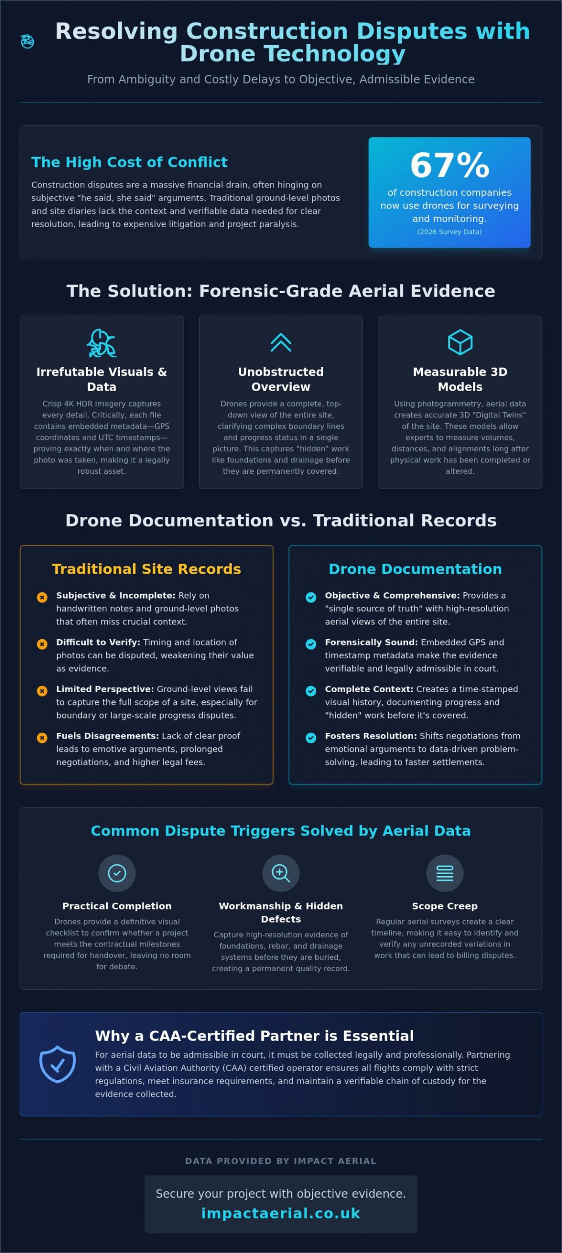
Drone Documentation vs. Traditional Site Records: A Comparative Analysis

Traditional site records often rely on ground-level photography and manual site diaries, which are frequently prone to obstruction and human error. When deploying drone photography for construction disputes, the contrast in data quality and efficiency is stark. Surveying a 10-hectare site manually can take days of exhaustive site walks; an enterprise drone completes the same task in minutes. This speed doesn’t just save time. It ensures that the visual record is a precise snapshot of a specific moment, preventing the “data drift” that occurs when manual surveys are spread across several days.

The perspective provided by a “God’s eye view” offers a comprehensive understanding that ground cameras simply cannot replicate. While a ground-level photo might show a specific defect, it often lacks the surrounding context necessary to prove how that defect impacts the wider project. Consistent, time-stamped progress intervals allow legal teams to rewind the clock. They can see exactly how a site evolved, providing a level of transparency that traditional records lack. This chronological clarity is often the deciding factor in resolving claims related to project delays or sequencing errors.

Data Depth and Context

Ground-level photos frequently miss the “big picture” of site logistics, such as the placement of heavy machinery or the flow of materials. Aerial data allows experts to zoom into specific snagging list items while maintaining a wide geographic context. This dual-layer approach provides a much higher cost-per-data-point value than traditional surveyors. Research indicates that drone usage can lead to a 55% cost reduction for infrastructure inspections compared to traditional methods. This makes it a financially sound choice for firms looking to tighten their dispute resolution processes.

Safety and Risk Mitigation

Safety is a cornerstone of professional site management, especially during an active dispute where tensions may be high. Using drones reduces the need for personnel to conduct “at height” inspections or enter hazardous, unreachable areas of a site. Capturing data remotely minimizes the requirement for expensive scaffolding or specialized access equipment just to verify a claim. The impact of professional drone surveys on site-wide safety protocols is significant. By removing human inspectors from high-risk environments, contractors often benefit from lower insurance premiums and a reduced likelihood of secondary health and safety disputes. This meticulous approach to data collection provides psychological comfort to all stakeholders, knowing that the evidence is gathered without compromising site safety.

Implementing Drone Data in Mediation, Boundary Disputes, and Litigation

Deploying professional drone photography for construction disputes follows a structured lifecycle, moving from preventative site records to forensic presentation in legal settings. This methodical approach ensures that data is not just captured, but is technically robust enough to withstand scrutiny by RICS surveyors, mediators, or high-court judges. By integrating aerial data early, project managers can resolve disagreements before they escalate into full-scale litigation.

The implementation process typically follows four critical steps:

  • Step 1: Pre-construction Baselines. We establish a definitive “before” state of the site and its boundaries. This aerial benchmark prevents future arguments regarding pre-existing damage to neighboring properties or site conditions.
  • Step 2: Periodic Progress Monitoring. Regular flights document “hidden” work, such as the placement of steel reinforcement or drainage systems. Capturing these elements before they’re buried under concrete is essential for proving compliance with building standards.
  • Step 3: Evidence Pack Preparation. We compile high-fidelity imagery and metadata into structured evidence packs. These are designed for immediate use by legal teams and expert witnesses during mediation.
  • Step 4: Courtroom Presentation. In complex cases, we present 3D models and orthomosaics that allow a judge to virtually “walk” the site. This provides a level of clarity that static, ground-level photos can’t match.

Resolving Boundary Disputes with Land Registry Overlays

Boundary arguments are often the most emotive and divisive issues in property law. We resolve these by matching current high-resolution aerial imagery with historical Land Registry title plans. This process identifies “boundary drift” caused by the gradual movement of hedges, fences, or unauthorized new builds. Using drone data as a neutral third-party record provides mediators with an indisputable foundation for settlement, often saving parties thousands in protracted legal fees. If your project requires this level of oversight, our construction site monitoring services provide the continuous data stream needed to protect your boundaries.

Proving Delays and Liquidated Damages

Proving why a project fell behind schedule is notoriously difficult without objective records. We use time-stamped aerial data to verify subcontractor presence and actual site progress against the master schedule. This documentation is vital for supporting Extension of Time (EOT) claims or defending against liquidated damages. When a contractor claims weather-related delays, our records provide the visual proof of site conditions on those specific dates. This shift toward data-driven resolution ensures that financial settlements are based on forensic facts rather than anecdotal site diaries.

Securing Your Project: Why CAA-Certified Drone Partners are Essential

The admissibility of drone photography for construction disputes depends entirely on the legality of the operation. Hiring an uncertified pilot creates a significant risk that your evidence will be dismissed in court or mediation. If a pilot fails to adhere to UK Civil Aviation Authority (CAA) regulations, the data they capture is often viewed as illegally obtained, rendering it useless for forensic purposes. Professional operators ensure that every flight is conducted within the law, providing the psychological comfort that your evidence is beyond reproach.

As of 2026, UK regulations require anyone operating a drone over 100g to hold a valid Flyer ID and Operator ID, with the latter requiring an annual fee of £12.34. For complex construction environments, a General Visual Line of Sight Certificate (GVC) is the industry standard. This certification proves the pilot has the technical training to manage high-risk sites safely and legally. Furthermore, professional partners maintain £5m commercial liability insurance as a baseline. This level of coverage is essential for construction projects, protecting all stakeholders from the financial fallout of unforeseen operational incidents.

Our meticulous approach extends to our geographic reach. Based in the West Midlands, we leverage our central location to provide comprehensive nationwide coverage across the UK. This allows us to maintain a consistent standard of forensic data collection for clients with multiple sites, ensuring that the methodology used to resolve a dispute in Birmingham is identical to one in London or Manchester.

Compliance and Legal Robustness

A valid UK drone license is more than a regulatory hurdle; it’s your guarantee that data is gathered ethically and legally. Every professional operation is underpinned by detailed Risk Assessment and Method Statements (RAMS), which are critical for site safety and insurance compliance. We also handle the complexities of GDPR and privacy laws. By ensuring that aerial data collection doesn’t infringe on the rights of neighboring properties, we prevent the creation of new legal liabilities that could complicate an existing dispute.

Why Impact Aerial for Construction Disputes?

We combine technical expertise in drone photography with a deep understanding of the property and commercial sectors. Our team manages the entire project lifecycle, from the initial consultation and flight planning to high-end post-production services. This end-to-end management ensures that the “digital truth” we provide is accurate, high-fidelity, and ready for use in any legal framework. Don’t leave your project’s resolution to chance with amateur data. Protect your project and resolve disputes with Impact Aerial today.

Resolving Site Disagreements with Forensic Precision

The shift toward data-centric resolution is no longer a luxury; it’s a necessity for modern construction management. High-fidelity visual evidence provides the “digital truth” needed to move past subjective site arguments and costly delays. Professional drone photography for construction disputes transforms complex site data into admissible forensic assets, ensuring that project timelines and workmanship are documented with clinical accuracy. By establishing a clear visual record, you don’t just win arguments; you prevent them from escalating in the first place.

Impact Aerial provides the technical expertise and regulatory compliance required for these sensitive cases. Our team of CAA GVC Certified Pilots utilizes advanced 4K HDR and Lidar capabilities to capture every detail with centimetre-level precision. We’re Birmingham-based with full UK-wide coverage and carry £5m commercial liability insurance to provide complete operational security. Whether you’re facing a boundary disagreement or a complex structural claim, we deliver the objective data you need to reach a resolution.

Request a Forensic Drone Survey Quote from Impact Aerial and secure the objective proof required to protect your project’s future. We’re here to help you move forward with confidence.

Frequently Asked Questions

Is drone photography admissible as evidence in a UK court?

Yes, aerial imagery is admissible provided it meets strict legal and technical standards. The data must be captured by a CAA-certified pilot who maintains a clear chain of custody and adheres to all safety regulations. Metadata such as embedded GPS coordinates and UTC time stamps are vital for verifying the authenticity and timing of the records in a legal setting.

How much does drone photography for a construction dispute cost?

Costs for these services vary significantly based on the site’s geographic size and the complexity of the data required. Factors such as the number of flight hours, the need for specialized sensors like Lidar, and the depth of post-production analysis all influence the final investment. We recommend requesting a bespoke quote to ensure the survey meets the specific forensic requirements of your case.

What is the difference between a standard photo and a forensic drone survey?

A standard photo is a simple visual snapshot, but a forensic drone survey provides measurable geospatial data. Forensic surveys use photogrammetry or Lidar to create 3D models with centimetre-level accuracy. This allows experts to verify precise volumes, distances, and structural alignments that a ground-level or non-specialized photo simply cannot provide.

Can drones help with boundary disputes involving the Land Registry?

Yes, drones are highly effective for resolving boundary issues by overlaying current high-resolution imagery onto official Land Registry title plans. This process identifies “boundary drift” caused by the movement of fences or hedges over time. It provides a neutral, objective record that helps mediators and legal teams settle disagreements based on technical facts rather than anecdotal claims.

Do I need my neighbour’s permission to use a drone for a boundary dispute?

You don’t always need explicit permission for the flight itself, but you must comply with privacy and trespass laws. Professional pilots follow strict CAA flight path regulations and data protection protocols to ensure the survey is legal. Ensuring that the drone photography for construction disputes is conducted ethically prevents the risk of the evidence being dismissed due to privacy violations.

What certifications should a drone pilot have for construction site work?

A professional pilot must hold a valid Flyer ID and Operator ID, along with a General Visual Line of Sight Certificate (GVC) for complex site operations. These qualifications prove the pilot is trained in meticulous risk assessment and safety management. It is also essential to verify they carry professional commercial liability insurance to protect all stakeholders during the operation.

Can drones identify structural defects that are invisible from the ground?

Yes, drones equipped with thermal sensors or high-zoom 4K cameras can pinpoint issues that ground inspections miss. Thermal imaging is particularly useful for identifying water ingress or heat loss behind building facades. Using drone photography for construction disputes allows you to document micro-cracks and material defects in hard-to-reach areas, providing proof of workmanship flaws before they lead to structural failure.

How quickly can I get drone evidence for an ongoing construction dispute?

Data collection is often completed in a single day once site permissions and safety assessments are finalized. The delivery of the final evidence pack depends on the complexity of the 3D modelling or post-production required. Most professional firms provide a structured timeline, ensuring that high-fidelity visual records are ready for use in mediation or litigation as quickly as possible.

Hire Professional Drone Photographer: The 2026 Guide to UK Aerial Services

What if the “affordable” drone pilot you just booked doesn’t actually have the legal right to fly near your commercial premises? You’re likely aware that high-resolution aerial data is no longer a luxury; it’s a competitive necessity for everything from construction site monitoring to PV solar farm thermal surveys. However, with the 2026 UK drone regulations now in full effect, the gap between a hobbyist and a certified expert has never been wider. It’s why more businesses now choose to hire professional drone photographer services that prioritize technical precision and risk mitigation over basic flight.

You shouldn’t have to worry about legal liability for non-compliant flights or hidden post-production costs that blow your budget. This guide will show you exactly how to secure 4K HDR imagery while ensuring total CAA compliance, including the latest Remote ID and UK class marking requirements. We’ll explore the critical steps to seamless project management, from initial flight planning and mandatory night-flying green lights to the final post-production edit. Discover how to leverage professional aerial filming and photography to gain a clear, compliant, and technically superior perspective on your next commercial project.

Key Takeaways

  • Understand the critical legal distinction between hobbyist flights and commercial operations to protect your business from shared liability under 2026 UK regulations.
  • Learn why enterprise-grade hardware featuring mechanical shutters and 4K HDR sensors is mandatory for high-precision technical surveys and commercial property marketing.
  • Use our professional checklist to verify a pilot’s CAA GVC status and Operational Authorisation before you hire professional drone photographer experts for complex urban projects.
  • Explore how specialized aerial data, from PV solar farm thermal surveys to construction site monitoring, provides measurable ROI and technical clarity for stakeholders.
  • Discover the importance of a structured workflow that integrates meticulous flight planning with high-tier post-production services for a seamless project delivery.

Why Hiring a Professional Drone Photographer is Essential in 2026

The decision to hire professional drone photographer services is no longer just about capturing a unique angle; it’s a fundamental requirement for corporate risk management. In 2026, the distinction between a hobbyist and a commercial operator is defined by strict regulatory compliance and technical capability. While the history of aerial photography began with tethered balloons and rudimentary cameras, modern operations involve sophisticated systems like Remote ID and UK class markings. These technical layers ensure that every flight is accountable to the Civil Aviation Authority (CAA), providing a level of transparency and safety that hobbyist flights simply can’t match.

To better understand the visual impact of professional aerial work, watch this helpful video:

Commercial projects carry inherent risks that a casual pilot isn’t equipped to handle. Since January 1, 2026, all new drones must carry specific UK class markings, from UK0 to UK6, which dictate where they can fly and their proximity to the public. If you hire professional drone photographer experts who use “legacy drones” without the proper Operational Authorisation for urban areas, you aren’t just risking poor results. You’re assuming legal risk. The CAA can hold both the pilot and the client liable for non-compliant flights, particularly in built-up areas where safety protocols are paramount.

The Hidden Risks of Using Uncertified Operators

Uncertified operators often lack the specific insurance required for commercial work. Standard hobbyist policies fail when a drone is used for financial gain, leaving a massive “insurance gap” if an incident occurs. Professional operators carry public liability coverage, often ranging from £1 million to £5 million, to protect your assets and your reputation. Beyond the legal threat, an unsafe flight can cause irreparable damage to your brand’s public image. Meticulous planning is the only way to mitigate these operational dangers.

The Commercial Advantage of Professional Perspectives

Professional aerial filming and photography provide a measurable return on investment. High-resolution 4K HDR imagery can increase online click-through rates for property listings by nearly 70% based on verified industry data. In the industrial sector, construction site monitoring allows project managers to track progress with high precision, potentially shortening project timelines by identifying errors early. The psychological impact of high-end visuals is undeniable. They signal to your clients that you value quality, safety, and technical excellence.

The Technical Edge: What Separates Pro Drone Services from Hobbyists

Technical superiority isn’t just a marketing claim; it’s the foundation of every successful aerial project. When you hire professional drone photographer specialists, you’re paying for enterprise-grade hardware that far exceeds the capabilities of standard consumer models. For example, the DJI Mavic 3 Enterprise series features mechanical shutters. These are essential for eliminating rolling shutter distortion when capturing high-speed architectural data or mapping large sites. Consumer drones often rely on electronic shutters, which can lead to warped imagery that doesn’t meet rigorous technical standards.

Professional equipment provides several critical advantages for commercial clients:

  • Mechanical Shutters: Prevents image “jello” effect during high-speed motion, ensuring crisp architectural lines.
  • RTK Precision: Real-Time Kinematic positioning provides centimeter-level accuracy for repeatable site monitoring.
  • Omnidirectional Sensing: Advanced obstacle avoidance allows for safe navigation in complex industrial environments.
  • Dual-Sensor Payloads: The ability to switch between high-resolution visual and radiometric thermal data on a single flight.

Reliability in the field is equally dependent on flight stability. Professional systems utilize RTK positioning to achieve a level of precision that consumer GPS simply cannot match. This accuracy is critical for repeatable construction site monitoring where images must be captured from the exact same coordinates over several months. Furthermore, these systems operate within the strict safety parameters defined by Civil Aviation Authority (CAA) regulations, ensuring that every flight is both stable and legally compliant.

Commercial-Grade DJI Enterprise Technology

High-resolution 4K HDR sensors are standard for capturing the fine architectural details required in high-end property marketing. However, the true value of enterprise technology lies in specialized applications. For instance, PV solar farm thermal surveys require radiometric thermal cameras to detect micro-cracks and cell failures that are invisible to the naked eye. These enterprise drones also boast superior wind resistance and signal stability, allowing for successful operations in weather conditions that would ground a hobbyist aircraft.

The Professional Project Lifecycle

Managing the lifecycle of a commercial project requires more than basic flight skills. When businesses hire professional drone photographer teams, they’re investing in a structured workflow that prioritizes safety and data integrity. This begins with rigorous pre-flight site assessments and airspace coordination. Once the data is captured, the work transitions to our post-production services. Editing accounts for approximately 50% of the final product quality, transforming raw data into cinematic video or 3D models. If you require a technical partner rather than just a pilot, explore our drone commercial property surveys for comprehensive data delivery.

Hire Professional Drone Photographer: The 2026 Guide to UK Aerial Services

Commercial Applications: From Property Marketing to Technical Surveys

The decision to hire professional drone photographer teams often moves beyond aesthetic appeal into the realm of actionable business intelligence. While the hardware discussed previously provides the foundation, the true value lies in how this technology integrates into specific industry workflows. From high-end residential marketing to complex industrial inspections, professional aerial services offer a level of detail and safety that ground-based methods cannot replicate. Adhering to UK Civil Aviation Authority drone regulations is mandatory for these commercial applications, ensuring that data collection doesn’t compromise public safety or legal standing.

Real Estate and Property Development

In the competitive UK property market, high-resolution imagery is essential for contextualising a building within its wider landscape. Professional pilots capture cinematic “hero shots” that highlight proximity to local infrastructure, green spaces, and transport links. This goes beyond simple photography; it includes creating immersive virtual tours that allow luxury listings to stand out to international investors. For commercial developers, these perspectives are vital for site planning and showcasing the scale of a project to stakeholders before the first brick is laid.

Technical Data and Construction Surveys

Construction site monitoring has been transformed by the ability to track progress from the air over time. Regular aerial flyovers provide project managers with a chronological record of development, helping to identify potential delays or logistical bottlenecks. Using drones for commercial property surveys allows for the identification of structural issues in high-access areas, such as church spires, chimneys, or expansive warehouse roofs, without the need for expensive scaffolding or risky manual inspections.

Industrial inspections also benefit from specialized sensors. Thermal analysis is increasingly used to assess energy efficiency by identifying heat loss in commercial buildings or detecting faults in PV solar arrays. This data-centric approach ensures that maintenance teams can target specific problem areas, reducing operational costs and downtime. In creative advertising, these same technical skills are used to capture sweeping, high-tier visuals for brand campaigns, proving that a meticulous, compliant approach to flight is the key to unlocking both creative and technical success.

The Professional Checklist: How to Vet Your Drone Pilot

Choosing to hire professional drone photographer services requires a shift in mindset from creative procurement to technical vetting. In 2026, the regulatory environment is too complex for casual hires based on a flashy Instagram feed alone. You need a verifiable paper trail that proves competence, legal standing, and operational safety. Vetting is your primary tool for risk management, ensuring that your commercial project remains compliant with national aviation standards while delivering high-tier data.

Understanding CAA Certifications in 2026

The foundational requirement for any commercial operator is their specific certification. While an A2 Certificate of Competence (A2 CofC) allows for basic flights in lower-risk environments, a General Visual Line of Sight Certificate (GVC) is the hallmark of a true professional. A GVC pilot has undergone rigorous practical assessments and is qualified to handle more complex operations. This certification is a prerequisite for obtaining an Operational Authorisation from the CAA, which is mandatory for flights in built-up urban areas or near uninvolved people. A valid UK drone license is non-negotiable; always verify a pilot’s credentials against the official CAA register before signing a contract.

Insurance and Risk Mitigation

Insurance is where uncertified operators frequently fail. Standard public liability policies often specifically exclude aviation activities or contain restrictive clauses that void coverage during commercial work. Professional operators maintain insurance that is strictly compliant with EC 785/2004 regulations. While some entry-level pilots carry £1 million in coverage, the industry gold standard for high-stakes commercial projects is £5 million. This level of protection ensures your business is shielded from significant financial loss in the event of hardware failure or accidental property damage.

Beyond the insurance certificate, a meticulous pilot will provide a comprehensive Risk Assessment and Method Statement (RAMS). This document should detail:

  • Site-specific hazard identification and mitigation strategies.
  • Emergency procedures and “lost link” protocols.
  • Airspace coordination and local authority permissions.
  • Specific hardware and software versions used for the mission.

Finally, examine a recent portfolio for technical consistency rather than just a few “lucky” shots. Look for crisp imagery across the entire frame and balanced exposure in challenging lighting conditions. Professional work should show no signs of rolling shutter distortion or pixelation in 4K HDR outputs. If you are ready to secure a fully vetted and insured partner for your next project, contact us for high-precision aerial filming and photography services across the UK.

Impact Aerial: Your Partner for Precision Drone Photography in the UK

Impact Aerial operates as a specialized technical consultancy rather than a standard creative agency. Based in Birmingham and serving the entire United Kingdom, we provide national coverage for organizations that require absolute regulatory compliance and high-tier visual data. When you decide to hire professional drone photographer specialists, you’re choosing a partner that understands the nuances of the 2026 UK aviation landscape. We don’t just fly; we manage complex aerial operations that prioritize data integrity and site safety.

Our commitment to excellence is reflected in our hardware choices and insurance standards. We utilize the latest DJI Enterprise drone technology, ensuring every mission benefits from RTK precision and high-resolution 4K HDR sensors. This technical foundation is backed by £5 million in commercial liability insurance, which is the industry gold standard for professional operators. This level of coverage provides the reassurance needed when operating near sensitive infrastructure or high-value commercial property. It’s a level of protection that consumer-level pilots simply cannot offer.

The Impact Aerial Difference

Our methodology is built on meticulous planning and adherence to safety-first protocols. Every project begins with a detailed site assessment and airspace coordination, ensuring that all flights are fully compliant with current CAA standards. We offer bespoke solutions tailored to the property, construction, and advertising sectors, providing a seamless transition from raw data capture to final delivery. Our in-house post-production services ensure that the final imagery or 3D models are polished, precise, and ready for stakeholder review. This includes technical color grading for cinematic video and the careful stitching of high-resolution stills for expansive drone commercial property surveys.

Get Started with Your Aerial Project

We provide a structured project lifecycle that values your time and project deadlines. From the initial consultation, we work to understand your specific data requirements, whether you need construction site monitoring or sophisticated virtual tour creation. Our team handles all necessary local permissions and risk assessments, removing the administrative burden from your internal staff. This allows your team to focus on the insights our data provides rather than the logistics of the flight itself.

Our typical project timeline is designed for efficiency, moving from the site flight to the final edit with transparent communication at every stage. We provide tailored quotes that reflect the technical complexity and scale of your mission. Hire Impact Aerial for your professional drone photography today to secure a compliant, expert partner for your next UK aerial project. We’re ready to deliver the high-precision imagery your commercial project demands.

Future-Proof Your Operations with Professional Aerial Intelligence

The landscape of UK aerial services has shifted toward a more structured and accountable model. Choosing to hire professional drone photographer experts ensures your projects benefit from 2026-compliant technology and meticulous risk management. You gain more than just a visual perspective; you secure data accuracy and legal protection that hobbyist operations cannot provide. Whether it’s for PV solar farm thermal surveys or construction site monitoring, the technical requirements of modern industry demand a specialist approach.

Impact Aerial provides the technical edge your business requires. Our CAA GVC Certified Pilots use the latest DJI Enterprise Hardware to deliver high-resolution results across the UK. With £5m Commercial Liability Insurance and specialized Birmingham-based national coverage, we offer the reliability needed for complex commercial missions. We’re proud of our track record in delivering high-precision data that supports informed decision-making.

Book Your Professional Drone Photography Consultation Today to discuss your specific requirements for technical surveys or high-end property marketing. We look forward to helping you achieve a superior perspective on your next project.

Frequently Asked Questions

How much does it cost to hire a professional drone photographer in the UK?

Pricing for aerial services depends on project complexity, location, and the specific technical requirements of the mission. Factors such as the use of specialized thermal sensors for PV solar farm surveys or the need for high-resolution 4K HDR imagery for property marketing will influence the final investment. Most professional operators provide bespoke quotes after an initial consultation to account for airspace coordination and post-production editing needs.

Do I need to get permission from my neighbours for drone photography?

You don’t strictly require permission from neighbours to fly over their property, but you must adhere to privacy laws and Civil Aviation Authority (CAA) regulations. Professional pilots ensure they don’t capture identifiable images of people or private data without consent, following the Data Protection Act 2018. When you hire professional drone photographer services, the pilot conducts a thorough risk assessment to ensure all flights remain respectful and legally compliant.

What happens if the weather is bad on the day of the drone shoot?

Professional pilots monitor weather conditions meticulously and will reschedule if wind speeds or precipitation exceed the safe operating limits of the hardware. Enterprise-grade drones generally have higher wind resistance than consumer models, but operational safety remains the absolute priority. Most professional operators include a weather clause in their agreements to allow for a flexible rescheduling window without financial penalty to the client.

Is it legal to fly drones in London or other major UK cities?

It is legal to fly in major cities, but it requires specific certifications and often an Operational Authorisation from the CAA. Flying in congested urban areas like London involves navigating restricted airspace and maintaining safe distances from uninvolved persons. Professional operators manage all necessary permissions and coordination with local authorities to ensure every urban flight is fully authorized and insured for your peace of mind.

How long does a typical professional drone photography session take?

A standard on-site session usually lasts between one and three hours, depending on the scope of the project. Simple property shots might be completed quickly, while comprehensive construction site monitoring or large-scale commercial property surveys require more time for systematic data capture. This timeframe excludes the essential pre-flight planning and the extensive post-production editing required to deliver high-tier professional assets.

What file formats will I receive for my aerial photos and videos?

Clients typically receive high-resolution JPEG or TIFF files for photography and MP4 or MOV files for video production. For technical projects, we can provide specialized data formats such as RAW files for advanced editing or radiometric thermal data for solar inspections. We ensure all deliverables are compatible with your existing marketing or project management software during the final post-production phase.

Can drones be used for indoor photography or filming?

Drones are highly effective for indoor use provided the space is sufficiently large and the pilot uses aircraft equipped with omnidirectional obstacle avoidance. Indoor filming is ideal for showcasing expansive warehouse interiors or large commercial developments. These flights require exceptional pilot skill and specific safety protocols because GPS signals are often unavailable or unreliable inside large structures.

What is the maximum height a professional drone can fly in the UK?

The legal height limit for drone operations in the UK is 120 meters, which is approximately 400 feet above the earth’s surface. This limit is strictly enforced by the Civil Aviation Authority to prevent conflicts with manned aircraft. If a specific commercial project requires a higher altitude, the operator must apply for a specific exemption or an enhanced Operational Authorisation involving additional safety coordination.

Drone Photography for Landscape Architects: Enhancing Design and Site Analysis

How much time does your practice lose correcting design errors caused by the low-resolution, outdated perspective of satellite imagery? For many professionals, the gap between a digital map and the physical reality of a site is a constant source of friction. You already know that successful landscape architecture depends on absolute precision. Whether you’re assessing complex topography or trying to convey the true scale of a masterplan to a stakeholder, static 2D data often fails to tell the whole story. With 67% of site monitoring and construction firms now utilizing aerial technology, the industry is rapidly shifting toward a more data-centric approach to site analysis.

Professional drone photography for landscape architects changes this dynamic by providing a data-rich visual narrative that bridges the gap between conceptual design and site reality. By leveraging high-resolution aerial imagery and drone-derived surveys, you can transform your workflow from the first site visit to the final client pitch. You’ll discover how to integrate topographic data directly into your CAD or BIM software, capture cinematic portfolio shots that win bids, and stay ahead of the 2026 UK CAA regulatory requirements. This guide explains how to use aerial technology to ground your designs in reality while ensuring every flight is safe, insured, and compliant.

Key Takeaways

  • Move from static ground-level perspectives to holistic aerial-first site analysis to better understand environmental stressors and site circulation.
  • Integrate professional drone photography for landscape architects into your full project lifecycle to enhance site analysis, concept development, and final handover.
  • Distinguish between simple marketing imagery and technical data collection, including how photogrammetry supports precise CAD and BIM integration.
  • Ensure project safety and legal compliance by understanding the specific CAA regulations and licensing required for commercial drone operations in the UK.
  • Streamline your workflow by partnering with technical specialists for end-to-end services, from pre-flight planning to high-end post-production editing.

The New Vantage Point: Why Landscape Architects are Adopting Drone Photography in 2026

Landscape design in 2026 requires more than a simple aesthetic vision; it demands a precise, technical understanding of the land. Professional drone photography for landscape architects has evolved into a sophisticated toolset that captures high-resolution visual data and georeferenced information. This technology marks a departure from traditional ground-level site analysis. Instead of relying on restricted views from the perimeter, architects now adopt an aerial-first methodology. This shift allows for a holistic understanding of site boundaries, neighboring infrastructure, and environmental stressors that are invisible from the ground.

To see how this technology transforms a site’s visual narrative, watch this helpful video:

One of the most significant advantages is the move away from outdated satellite imagery. Standard digital maps often rely on data that is years old, failing to account for recent construction or vegetation changes. Drones provide real-time site context, which is critical for 2026 Sustainable Drainage Systems (SuDS) planning. By identifying natural water flow paths and existing drainage bottlenecks from above, designers can create more resilient landscape interventions that respond to the actual conditions of the terrain.

The Evolution of the Site Visit

Manual site measurements often involve days of walking the terrain with tape measures and handheld cameras. Professional drone services significantly reduce this timeframe. Using high-specification DJI Enterprise hardware, pilots can capture comprehensive data across sprawling or hazardous terrain that would be unsafe for manual inspection. This efficiency doesn’t sacrifice the “genius loci” of a project. Aerial perspectives reveal the spirit of a place by highlighting how light, shadow, and topography interact across the entire site simultaneously, providing a perspective that was previously impossible to document.

Bridging the Gap Between Concept and Reality

Architects often struggle to explain complex spatial relationships to clients who can’t read a technical 2D plan. Aerial views provide an intuitive bridge. By showing a proposed design overlaid on high-resolution Photogrammetry data, stakeholders see exactly how the project fits into the wider environment. This clarity is vital for planning applications, where documenting “before” conditions with precise imagery can prevent costly delays. In 2026, site context is defined as a fusion of 4K HDR visuals and GPS-tagged data that provides a single, undisputed source of truth for the entire design team.

From Concept to Completion: Enhancing the Design Workflow with Aerial Imagery

Integrating drone photography for landscape architects into a project’s lifecycle provides a consistent data stream that links conceptual ideas to physical outcomes. While the previous section highlighted the initial vantage point, the true value lies in how this imagery evolves through the design stages. During site analysis, aerial views reveal circulation patterns and environmental stressors that are often invisible from the ground. You can observe how pedestrians interact with existing boundaries or identify hidden desire lines that should inform your new layout. This high-level perspective ensures your design responds to actual human behavior rather than static assumptions.

Site Analysis and Environmental Context

Before the first sketch is drawn, a comprehensive drone survey establishes a baseline of existing conditions. High-resolution imaging allows you to map tree canopies and vegetation with centimeter-level precision, which is essential for biodiversity net gain assessments. Thermal sensors can also detect drainage issues or specific micro-climates by identifying areas of moisture retention or heat concentration. This technical data informs more accurate feasibility studies, reducing the risk of expensive design changes later in the process. When operating in these complex environments, we always adhere to UK Civil Aviation Authority drone regulations to ensure site safety and legal compliance.

Client Presentations and Emotional Buy-in

Winning approval for a visionary masterplan requires more than technical drawings. It demands an emotional connection. Using a professional aerial filming drone, you can produce cinematic narratives that guide stakeholders through the proposed space. By overlaying 3D renders onto actual 4K HDR site photos, you create “verified view” montages that demonstrate the project’s real-world impact. This level of visual fidelity is often the deciding factor in winning high-value commercial tenders or securing planning permission from local authorities. If you want to elevate your next proposal, consider how professional aerial filming can articulate your design intent.

The workflow doesn’t end at the construction phase. Drones provide an efficient way to monitor progress and document “as-built” conditions. These final records are invaluable for long-term maintenance contracts, providing a clear visual map of underground services, irrigation systems, and planting layouts before they are covered by growth. This comprehensive documentation ensures that designers using drone photography for landscape architects can provide clients with a precise record of the completed works, ensuring the design vision is maintained throughout the project’s operational life.

Drone Photography for Landscape Architects: Enhancing Design and Site Analysis

Beyond the ‘Pretty Picture’: Photogrammetry and 3D Modelling for Site Analysis

While high-resolution visuals win pitches, the true engineering value of drone technology lies in its ability to generate measurable, actionable data. Professional drone photography for landscape architects has transitioned from simple visual documentation to precise technical collection. This shift moves the drone from the marketing department into the core design team. By capturing data that is georeferenced and scaled, we provide a foundation for precision engineering that traditional photography lacks. It’s no longer just about the view; it’s about the data that lives within the image.

Achieving this level of precision requires specific hardware and expertise. By utilizing a specialized survey drone equipped with Real-Time Kinematic (RTK) technology, we achieve centimetre-level accuracy that standard consumer drones cannot replicate. These data sets integrate seamlessly into AutoCAD, Revit, and BIM workflows. This allows for a “single source of truth” where architects, engineers, and contractors all work from the same high-fidelity model. This integration reduces errors during the construction phase and ensures that the final build aligns perfectly with the initial site analysis, saving both time and project budget.

Understanding Photogrammetry and Point Clouds

Photogrammetry involves processing hundreds of overlapping high-resolution images into a cohesive 3D model. This process creates a digital twin of the landscape, including existing structures, vegetation, and terrain features. From this data, we generate high-density point clouds and topographic maps that are essential for accurate grading and drainage planning. Point clouds allow architects to measure distances and volumes directly from their desktop, eliminating the need for repeated site visits to verify minor measurements. This digital approach to site analysis provides a level of detail that ground-based surveys often miss, especially in large-scale masterplanning projects.

LiDAR vs. Photogrammetry for Landscape Design

Choosing the correct sensor is a matter of technical necessity and project scale. For most landscape projects, photogrammetry provides excellent visual detail and sufficient accuracy for design purposes. However, when a project involves penetrating thick canopy or dense undergrowth to understand the underlying topography, LiDAR (Light Detection and Ranging) becomes essential. LiDAR sensors emit laser pulses that “see” through gaps in foliage to map the true ground surface. Impact Aerial utilizes DJI Enterprise sensors to deliver high-fidelity data across both methods. As discussed in A Guide to Drones for Landscape Architects, understanding these technical differences is key to selecting the right service for your project’s specific environmental challenges. We provide the technical consultancy needed to ensure you receive the most cost-effective data for your specific site requirements.

Safety is the primary concern for any professional architecture practice. While the visual benefits of drone photography for landscape architects are undeniable, the operational risks must be managed through strict adherence to UK aviation law. Commissioning an unlicensed pilot doesn’t just risk a fine; it places your entire firm at a significant liability disadvantage. Professional drone operations require a methodical approach to risk management that hobbyist flights simply cannot provide. This ensures that every flight over a project site is conducted with the same level of professional oversight as the design work itself.

The Importance of CAA GVC Certification

For commercial work in congested urban areas, a pilot must hold a specific drone license known as the General Visual Line of Sight Certificate (GVC). This qualification demonstrates that the operator has undergone rigorous training and assessment approved by the Civil Aviation Authority. Unlike hobbyists, GVC-certified pilots are authorised to operate in complex environments, provided they follow a documented Operations Manual. At Impact Aerial, we combine this certification with £5m commercial liability insurance as standard. This level of coverage is essential for architecture firms to protect against third-party risks during site visits or construction monitoring. We don’t just fly; we execute a meticulous flight plan that includes airspace checks, weather monitoring, and emergency protocols for every mission.

Data Privacy and Public Relations

Filming in public or residential spaces introduces complex GDPR and privacy considerations. A professional operator acts as a liaison between your project and the local community. We manage the legal requirements for data capture, ensuring that any identifiable information is handled according to current privacy laws. As of January 2026, new UK Remote ID requirements mean that most commercial drones must broadcast their identity and location in real-time. This increases transparency and accountability, making it even more vital to use compliant hardware and registered operators. Our pilots are trained to communicate effectively with local authorities and the public, maintaining the professional reputation of your firm while capturing the data you need.

Adhering to these regulations ensures your project data is legally defensible and safe to use in public pitches or planning applications. If you are planning a project in a high-density area, our Drone Commercial Property Surveys provide the compliant, high-resolution data required to move your design forward without regulatory friction.

Every mission begins with a comprehensive risk assessment. For urban landscape projects, this involves identifying potential hazards such as overhead power lines, public footpaths, and restricted airspace. By documenting these factors before the drone leaves the ground, we eliminate the uncertainty that often surrounds aerial data collection. This disciplined approach to safety is what separates professional drone photography for landscape architects from casual aerial snapshots, providing you with psychological comfort and tangible project benefits.

Partnering for Precision: Professional Drone Services for Landscape Design Projects

Impact Aerial acts as a technical extension of your design practice. While some firms consider a DIY approach, the opportunity cost of an architect attempting to become a full-time pilot is often overlooked. Professional drone photography for landscape architects requires more than just owning a device; it demands continuous technical training, hardware maintenance, and strict regulatory compliance. By partnering with us, you can remain focused on design and client engagement while we handle the complexities of flight operations and data processing.

We utilise professional-grade DJI Enterprise hardware that far exceeds the capabilities of consumer models. These systems are designed for stability in varied weather conditions and carry superior sensors that deliver the high-fidelity data required for professional site analysis. Our end-to-end service covers everything from pre-flight safety planning to sophisticated post-production editing. This ensures you receive assets that are ready for immediate use in your design presentations or technical reports.

Why Hire a Professional Drone Service?

The primary advantage of outsourcing is cost-efficiency. You avoid the significant overheads associated with specialist commercial insurance, hardware depreciation, and the annual fees for pilot certifications. Our team provides quality assurance through guaranteed 4K HDR output and meticulously processed technical data that aligns with your project standards. Whether you’re managing a small residential garden or a massive urban regeneration project, we provide the scalability to meet your specific project requirements without you needing to invest in additional internal resources.

Getting Started with Impact Aerial

Our process begins with a detailed consultation to match the right sensor and flight plan to your specific design goals. We don’t just capture images; we provide data in formats that are ready for integration into your AutoCAD, Revit, or BIM software. This ensures a seamless transition from our aerial data collection to your digital design environment. We invite you to view our portfolio of drone photography tailored specifically for the built environment to see the quality of our output first-hand.

The final stage of our partnership involves delivery and comprehensive support. Our post-production services ensure that every video or survey is polished and professional, reflecting the high standards of your architectural practice. If you’re ready to enhance your workflow with precise, data-rich imagery, contact us today for a bespoke quote for your next landscape project.

Elevating Your Design Workflow with Precision Aerial Data

Adopting an aerial-first approach to site analysis is no longer a luxury for modern practices; it’s a technical necessity for those who demand precision and efficiency. By transitioning from static satellite maps to real-time, high-resolution data, you ensure that every design decision is grounded in the physical reality of the site. We’ve explored how professional drone photography for landscape architects bridges the gap between conceptual sketches and as-built accuracy, providing a single source of truth for your entire design team. This data-rich visual narrative doesn’t just win client pitches; it mitigates risk throughout the project lifecycle.

Impact Aerial provides the technical expertise and operational security your projects deserve. Our CAA GVC Certified Pilots utilise DJI Enterprise Grade Hardware to deliver centimetre-level accuracy while maintaining £5m Commercial Liability Insurance for your peace of mind. We handle the complexities of UK aviation regulations so you can focus on creating resilient, visionary landscapes. If you’re ready to transform your site analysis with high-fidelity imagery and technical surveys, request a bespoke drone photography quote for your landscape project today. We look forward to supporting your next project with the precision it requires.

Frequently Asked Questions

Do I need a special license to use drone photography for my landscape architecture firm?

Yes, any commercial use of drones in the UK requires specific registration and, in most professional cases, a qualification from the Civil Aviation Authority (CAA). You must have an Operator ID and the pilot must hold a Flyer ID. For projects in congested areas or near people, a General Visual Line of Sight Certificate (GVC) is legally required to ensure the operation remains compliant with safety standards.

Can drone data be integrated into AutoCAD or Revit for site analysis?

Professional drone data is designed for seamless integration with industry-standard design software. We provide processed outputs such as georeferenced orthomosaics in .TIFF format and 3D point clouds in .LAS or .OBJ formats. These files allow you to overlay high-resolution site context directly onto your existing CAD drawings or BIM models, ensuring your design is built upon an accurate digital twin of the landscape.

What is the difference between photogrammetry and a standard aerial photo?

A standard aerial photo is a single, static image used primarily for visual reference or marketing. Photogrammetry is a technical process that uses hundreds of overlapping images to create a measurable 3D model. While a photo shows you what a site looks like, photogrammetry provides a data-rich environment where you can calculate volumes, distances, and precise elevation changes across the entire project area.

How much does professional drone photography for a landscape project cost in the UK?

The cost of drone photography for landscape architects depends on several technical factors, including the size of the site, the complexity of the airspace, and the specific data outputs required. A simple visual progress shoot involves different planning requirements than a full topographic survey with RTK accuracy. You should check with a professional operator for a bespoke quote that accounts for your specific project scale and location.

Is it safe to fly drones on busy urban construction sites?

It is safe to fly in complex urban environments when you use a pilot who follows strict CAA-approved risk management protocols. We use DJI Enterprise hardware equipped with 360-degree obstacle avoidance and redundant systems to maintain flight stability. Every mission on a busy site is preceded by a detailed risk assessment to identify hazards such as cranes, power lines, and public footpaths, ensuring the safety of all personnel on the ground.

What happens if it rains on the day of the scheduled drone shoot?

We monitor weather forecasts meticulously and will typically postpone a flight if rain or high winds exceed the safe operating limits of the hardware. High-quality data collection requires clear visibility and stable conditions to ensure the 4K visuals and technical sensors perform optimally. If a shoot is cancelled due to weather, we work closely with your team to reschedule for the next available clear window to avoid project delays.

How long does it take to receive the processed 3D models or edited footage?

Standard aerial photography and unedited video files are typically delivered within 24 to 48 hours of the flight. More complex datasets, such as processed 3D point clouds or topographic maps, require significant computational time and usually take three to five working days to complete. We provide these files via secure digital transfer, ensuring your design team can begin using the data as quickly as possible.

Can drones help with tree surveys and TPO (Tree Preservation Order) assessments?

Drones are highly effective tools for assessing vegetation and managing Tree Preservation Orders across large sites. High-resolution imagery allows for the precise mapping of tree canopies and the identification of specific species from an inaccessible vantage point. This data provides a clear visual record of tree health and position, which is invaluable when submitting planning applications or conducting biodiversity net gain assessments for sensitive landscape projects.

Aerial Site Overview Photography: The Professional Guide to Site Intelligence in 2026

What if the most critical data for your 2026 project planning is currently three years out of date and blurred beyond recognition? You likely recognize that relying on generic satellite imagery often leads to costly planning errors and significant coordination delays. It’s frustrating when you can’t get a clear, real-time view of your assets without worrying about the complexities of UK drone laws or potential trespassing. Utilizing professional aerial site overview photography provides a living dataset that static maps and historical archives simply cannot replicate.

This guide will help you master the technical and regulatory requirements for capturing high-resolution imagery that drives project efficiency and safety. You’ll learn how to navigate the permanent UK drone framework established in January 2026, including the latest Remote ID mandates and UK class markings. We will cover everything from producing 4K HDR imagery for stakeholder presentations to ensuring your operations meet EC 785/2004 insurance standards for total site intelligence. By the end, you’ll understand how to integrate compliant, high-tier visual data into your professional workflows to ensure your projects remain on track and fully transparent.

Key Takeaways

  • Learn why 4K HDR imagery and orthorectification are essential for converting visual data into precise, actionable site measurements.
  • Understand the critical advantages of bespoke aerial site overview photography over outdated satellite data for real-time project decision making.
  • Identify the mandatory 2026 UK compliance standards, including CAA GVC certification and the necessity of £5m public liability insurance for high-risk environments.
  • Master the planning process by defining specific project goals and establishing the ideal frequency for recurring construction site monitoring.
  • Discover how professional site overviews across the UK combine meticulous safety protocols with high-tier data quality to protect your project’s ROI.

What is Aerial Site Overview Photography and Why Does it Matter?

Professional aerial site overview photography represents the transition from static, historical records to dynamic site intelligence. Unlike traditional mapping, this process involves deploying advanced drone platforms to capture bespoke, high-resolution imagery specifically tailored to the current state of a project. It’s not just a photograph; it’s a data-rich asset that provides stakeholders with a comprehensive visual understanding of their assets in real-time. This level of clarity is essential for modern project management where precision is a non-negotiable requirement.

By leveraging these visual datasets, project managers can significantly reduce the requirement for frequent, expensive, and time-consuming site visits. This “site intelligence” allows teams to identify potential hazards, verify contractor progress, and coordinate logistics from a remote office. It’s a precise method for ensuring that every stakeholder is looking at the same, up-to-date reality rather than outdated archives. When everyone has access to the same high-resolution perspective, the risk of miscommunication and planning errors drops significantly.

To better understand the evolution and impact of this technology, watch this helpful overview:

Bespoke Photography vs. Satellite Imagery

The difference in quality between bespoke drone data and satellite imagery is stark. While typical satellite services offer resolutions measured in meters per pixel, professional drone captures achieve sub-centimeter accuracy. This level of detail is critical for orthophotography, where images are geometrically corrected to allow for accurate measurements directly from the photo. Satellite imagery is often years out of date and frequently obscured by cloud cover. Bespoke aerial site overview photography allows you to choose the exact time, weather conditions, and specific low-altitude angles required to highlight critical site features that a vertical satellite orbit simply cannot see. This ensures you’re working with current facts rather than historical approximations.

Key Applications Across the Project Lifecycle

Professional aerial data provides tangible value at every stage of a development. It serves as a single source of truth that evolves alongside the project, supporting various departments from engineering to marketing. The primary applications include:

  • Pre-construction: Aerial surveys are used for initial site planning, baseline environmental assessments, and identifying existing site constraints before any ground is broken.
  • Construction phase: Regular flights facilitate weekly or monthly construction site monitoring. This provides stakeholders with clear, chronological evidence of progress and helps to resolve contractor disputes quickly with visual proof.
  • Post-construction: Once the project is complete, drones capture high-end 4K HDR visuals for commercial property marketing, virtual tours, and final handover documentation to the client.

By integrating these high-tier visual perspectives early in the project lifecycle, firms can ensure a higher standard of safety and operational transparency. It’s an investment in precision that pays dividends through reduced rework and streamlined stakeholder reporting.

The Technical Standards of Professional Site Photography

High-tier sensor technology is the foundation of professional aerial site overview photography. We employ 4K HDR cameras to preserve critical detail in deep shadows and bright highlights. This is particularly vital on active construction sites where reflective materials and dark excavations exist side-by-side. Visual depth serves as a technical requirement for identifying structural anomalies or safety hazards that lower-resolution equipment might miss. Precision is our priority.

Our team utilizes DJI Enterprise hardware to maintain maximum stability and data consistency. These industrial-grade platforms offer superior wind resistance and flight precision compared to consumer models. This hardware reliability allows us to follow UK Civil Aviation Authority (CAA) guidance with total compliance. Capturing high-resolution aerial site overview photography requires a clear understanding of the difference between vertical and oblique perspectives. While vertical shots provide the basis for mapping, oblique angles offer the depth needed for stakeholder visualization.

Understanding Orthorectification and Accuracy

Orthorectification is the technical process of removing lens distortion and the “lean” of tall buildings to create a geometrically correct image. By processing nadir (top-down) imagery through specialized software, we generate a 2D map where every pixel represents a precise coordinate. This step is essential for any drone survey aimed at extracting measurements. Integrating RTK-enabled GPS metadata ensures that these site maps are accurate to within centimeters. This allows for reliable volume calculations and site boundary verification without the need for manual ground-based measurements.

Perspective and Cinematic Angles for Marketing

Vertical maps are excellent for data, but oblique (angled) photography provides the context necessary for stakeholder engagement. These shots highlight how a site interacts with surrounding infrastructure like roads and rail links. We often schedule these captures during “golden hour” to maximize property appeal, using techniques detailed in our guide on the aerial filming drone. This combination of technical data and cinematic perspective ensures your site intelligence serves both engineering and commercial teams. If you require this level of technical precision for your next project, our aerial photography services provide the high-end output required for professional site management.

Compliance and Safety: The UK Regulatory Framework

Safety is the primary concern for any commercial flight operation. In 2026, the legal landscape for drone flights is more structured than ever before. Commissioning professional aerial site overview photography requires a partner who understands the intricacies of the law. It’s not just about getting the shot; it’s about protecting your business from liability and ensuring everyone on site remains safe. Professional operators differentiate themselves through rigorous certification and comprehensive insurance coverage that hobbyists simply don’t possess.

A non-negotiable standard for any construction project is £5m public liability insurance. This level of coverage provides the necessary security for high-value environments and complex infrastructure. In dense urban settings, a standard license isn’t enough. Pilots often require specific Operational Authorization from the CAA to fly closer to people or buildings than standard rules allow. Adhering to UK Civil Aviation Authority regulations ensures that every flight is conducted within a legal framework that prioritizes public safety and data privacy. This meticulousness provides the reassurance that your project remains compliant and fully protected.

CAA Regulations and the GVC Standard

The General Visual Line of Sight Certificate (GVC) is the benchmark for professional competency in 2026. This certification proves that a pilot has undergone formal training and practical assessment. It covers advanced airmanship, meteorology, and emergency procedures. For a deeper look at these requirements, see our UK drone license guide. Every mission begins with a detailed pre-flight risk assessment. This document identifies potential hazards, from overhead power lines to nearby schools, and outlines the specific mitigation steps taken to ensure a safe flight. We don’t leave safety to chance.

Risk Mitigation on Active Construction Sites

We understand that construction sites are busy, high-stakes environments. Our operations are designed to integrate seamlessly without causing delays or disrupting your workforce. We use a structured approach to manage risk during every flight:

  • Exclusion Zones: We establish temporary takeoff and landing areas to keep personnel at a safe distance from the aircraft.
  • Dedicated Spotters: Our team uses visual observers to maintain 360-degree awareness of the airspace and ground activity.
  • Site Coordination: Pilots coordinate directly with site managers before takeoff to confirm active crane movements or scheduled deliveries.
  • Technical Fail-safes: Modern DJI Enterprise drones include multiple sensors for obstacle avoidance and automatic Return to Home (RTH) protocols.

This meticulous approach allows us to deliver high-quality aerial site overview photography while your team remains focused on their work. It’s about providing psychological comfort alongside tangible data. By prioritizing these safety protocols, we ensure that site intelligence never comes at the expense of operational security.

How to Plan a Successful Aerial Site Overview Shoot

Effective planning ensures that aerial site overview photography delivers a tangible return on investment. It’s not enough to simply fly a drone; you must align the flight path with your specific project objectives. Start by defining the scope. Are you looking for cinematic visuals to drive commercial property marketing, or do you require technical imagery for construction site monitoring? This distinction dictates everything from the hardware used to the timing of the flight.

Establish your desired shoot frequency early. A one-off baseline capture provides a vital historical record, but recurring progress shots offer the most value for long-term project management. Coordination with site staff is equally critical. Ensuring the site is ‘photo-ready’ involves clearing unnecessary vehicles or debris that might obscure key features. This meticulous preparation guarantees that the final output is professional and ready for stakeholder review.

Defining Your Visual Requirements

You need to determine the required resolution and identify specific areas of interest (AOIs) before the pilot arrives. High-resolution stills are standard, but you might also require 3D modeling or virtual tour creation for a more immersive site overview. Utilizing professional drone services allows for a more integrated approach to project management. This ensures that the data captured meets the technical needs of your engineering team while also satisfying the visual requirements of your marketing department.

Timing and Environmental Considerations

Weather monitoring is a non-negotiable part of the planning process. High winds or heavy rain don’t just impact safety; they degrade image quality. We monitor local forecasts to choose the optimal window for flight. The time of day is just as important. We aim to avoid long shadows that can hide critical site details, unless a specific ‘golden hour’ look is requested for marketing purposes. For multi-site projects, we prioritize consistent angle replication. This allows stakeholders to compare different locations with a standardized visual perspective, making it easier to track progress across your entire portfolio.

The final step is determining your post-production needs. Do you require RAW files for maximum editing flexibility, or are high-resolution TIFFs and PDF reports more suitable for your internal documentation? We provide a range of post-production services to ensure your aerial site overview photography is delivered in the format that best supports your workflow. If you’re ready to implement a data-driven approach to your next project, explore our professional construction site monitoring solutions to see how we can streamline your operations.

Impact Aerial: Professional Site Overviews Across the UK

Based in Birmingham and providing comprehensive nationwide coverage, Impact Aerial delivers a specialized approach to site intelligence. We recognize that high-resolution visual data is a critical asset for modern project management. Our team doesn’t just capture images; we provide a structured data service that integrates seamlessly into your professional workflow. By combining our regional expertise with a broad operational reach, we ensure that your projects receive consistent, high-tier results regardless of their location in the UK.

The “Impact” difference is rooted in our commitment to meticulous technical standards. We utilize 4K HDR technology to ensure that every aerial site overview photography project results in crisp, actionable data. Beyond the flight itself, we provide extensive post-production services. This includes everything from detailed image editing to the development of immersive virtual tour creation. This end-to-end service model ensures that the data we collect is ready for immediate use in stakeholder presentations or internal progress reviews.

Why Industry Leaders Trust Impact Aerial

Our reputation for excellence is built on a foundation of reliability and technical proficiency. We understand the high-stakes nature of commercial environments and prioritize risk mitigation in every mission. Industry leaders choose us because we provide:

  • Industrial Hardware: We exclusively use commercial-grade DJI Enterprise hardware to ensure flight stability and superior data output.
  • Verified Compliance: Every pilot is CAA GVC certified, operating under strict safety protocols that meet the latest 2026 standards.
  • Comprehensive Protection: We provide the psychological comfort of £5m public liability insurance, a mandatory requirement for most UK construction and infrastructure sites.
  • Technical Focus: Our operations are grounded in a meticulous, data-centric approach that prioritizes precision over flashy visuals.

Get Started with Your Site Overview

Initiating a project with Impact Aerial is a structured and transparent process. We begin with a detailed consultation to assess your site’s specific requirements and any unique operational constraints. Once we’ve established the project scope, our team handles all necessary flight planning and regulatory notifications. After the flight, our post-production team processes the raw data into your required formats, ensuring a smooth transition from capture to delivery. If you’re ready to enhance your project’s transparency and efficiency with professional aerial site overview photography, Contact Impact Aerial for a Professional Quote today.

Elevating Your Site Intelligence for 2026 and Beyond

Professional site management in 2026 demands a level of precision that only bespoke aerial data can provide. You’ve seen how 4K HDR imagery and orthorectified maps replace outdated satellite imagery with real-time site intelligence. By prioritizing technical standards and rigorous planning, your project teams can significantly reduce physical site visits while maintaining total transparency for all stakeholders. This structured approach ensures that every decision is based on current facts rather than historical approximations. It’s about moving beyond simple photos towards a comprehensive, data-driven workflow.

Success in this expanding industry relies on an unwavering commitment to safety and regulatory compliance. Utilizing professional aerial site overview photography ensures that your operations are backed by CAA GVC certified pilots and the security of £5m commercial liability insurance. Using industrial-grade 4K HDR DJI Enterprise equipment, Impact Aerial delivers the high-tier output required for complex urban and industrial environments. We provide the technical expertise and meticulous attention to detail that drives project efficiency and safety across the UK.

Ready to transform your project data into actionable intelligence? Request a Bespoke Site Overview Quote from Impact Aerial and secure the precise insights your project deserves. We look forward to helping you master your site’s visual data and protecting your project’s ROI.

Frequently Asked Questions

What is the difference between aerial photography and a drone survey?

Aerial photography focuses on capturing high-quality visual representations for marketing, stakeholder presentations, or basic progress monitoring. A drone survey is a data-centric process that uses photogrammetry to create 2D or 3D maps with measurable accuracy. While photography provides a clear visual perspective of a project, a survey provides the technical data required for precise engineering and volume calculations. Both services are essential components of modern site intelligence.

How much does professional aerial site overview photography cost in the UK?

Professional fees for aerial site overview photography are structured according to the complexity, duration, and technical requirements of each mission. Costs typically depend on whether you require a short site visit for a handful of high-resolution stills or a full day of cinematic filming and technical mapping. We recommend requesting a bespoke quote to ensure the pricing reflects your specific project requirements and any unique safety constraints involved.

Do I need to notify my neighbors before a drone shoot?

There’s no universal legal requirement to notify neighbors for every flight, but it’s a critical part of our risk assessment process. Adhering to UK GDPR and data privacy regulations means we must ensure that we don’t capture identifiable personal data of individuals outside the site boundary. We often advise clients to inform local residents as a matter of professional courtesy to maintain positive community relations during the project.

Can drones fly over active construction sites in urban areas?

Flights over active urban construction sites are permissible provided the operator holds the correct permissions from the aviation authorities. Professional pilots utilize specific Operational Authorisation to manage the increased risks of built-up environments. This involves establishing strict exclusion zones and using dedicated spotters to ensure the aircraft remains a safe distance from personnel and third-party property at all times during the operation.

How often should I have site overview photos taken for progress monitoring?

The frequency of progress monitoring depends on your project’s specific milestones and the pace of structural change. High-intensity builds often benefit from weekly captures to track rapid developments and logistical shifts on the ground. For larger infrastructure projects with longer timelines, monthly site overviews are usually sufficient to provide stakeholders with an accurate and reliable chronological record of the project’s progress.

What file formats will I receive for my site overview?

You’ll receive your final data in formats that best suit your internal professional workflows. We typically provide high-resolution JPEGs or TIFFs for presentations and RAW files if your team requires maximum editing flexibility in post-production. For technical site reports or 3D modeling, we deliver PDF summaries and industry-standard data files that are fully compatible with most modern CAD and BIM software platforms.

How long does a typical aerial site overview shoot take?

A standard mission for aerial site overview photography typically requires between one and four hours on-site. The exact duration depends on the site’s total acreage and the number of specific areas of interest we need to capture. This timeframe includes essential pre-flight safety checks, site walk-throughs with the manager, and the actual flight time required to secure all necessary high-resolution angles.

Are your drone pilots CAA certified and insured?

Every pilot in our team is fully CAA GVC certified and operates under our strict organizational safety protocols. We maintain £5m in commercial public liability insurance to provide total reassurance and protection for our clients. This level of certification and coverage is a non-negotiable standard for any professional drone operation on UK commercial or industrial sites in 2026.

Using Drone Photography for Property Listings in the UK: The 2026 Seller’s Guide

UK properties utilizing professional drone photography for property listings uk now sell up to 68% faster than those relying solely on traditional ground-level imagery. In a competitive 2026 market, a stagnant listing on Rightmove or Zoopla is often the result of failing to capture a property’s true scale and environmental context. You’ve likely felt the frustration of trying to convey the grandeur of a sprawling estate or a unique garden layout through a standard lens, only to see potential buyers scroll past without a second thought.

It’s understandable to feel anxious about evolving drone laws or potential privacy complaints, but professional aerial cinematography has transitioned from a luxury to a tactical necessity. This guide demonstrates how to leverage 4K HDR footage to achieve a 43% higher click-through rate while ensuring your marketing remains fully CAA compliant. We’ll explore how to navigate GVC certification, insurance mandates, and the latest Remote ID requirements to provide total peace of mind. You’ll learn how to transform your agency’s brand image, increase offer-to-viewing ratios, and secure significantly faster completion times.

Key Takeaways

  • Master the “3-second rule” on major property portals to significantly increase engagement and secure a 43% higher click-through rate for your listings.
  • Learn how cinematic ‘Orbit’ and ‘Reveal’ shots provide a comprehensive exterior condition report and showcase the property’s relationship with the surrounding landscape.
  • Understand the critical legal shift from PfCO to GVC and why using a CAA-certified operator is mandatory for professional liability and safety compliance.
  • Maximise your return on investment in drone photography for property listings uk by strategically timing shoots for the ‘Golden Hour’ to achieve the most flattering light.
  • Discover the technical benefits of professional-grade drone hardware and expert post-production editing in creating a high-prestige brand image for your agency.

Table of Contents

The Science of First Impressions: Why Drone Footage Sells UK Property 68% Faster

Professional property marketing has moved beyond simple aesthetics. In the 2026 market, drone photography for property listings uk functions as a sophisticated hybrid of cinematic storytelling and architectural documentation. It’s no longer enough to show what a house looks like; you must demonstrate how it sits within its environment. The history of aerial photography illustrates a clear trajectory from specialized surveyance to an essential commercial tool. Today, this technology provides the technical precision required to justify premium valuations while delivering the visual impact needed to stop the scroll.

On major portals like Rightmove and Zoopla, the “3-second rule” is absolute. Potential buyers make a subconscious decision to click or skip within moments of seeing a thumbnail. Static, ground-level images often struggle to compete in a saturated feed. By contrast, high-quality 4K HDR footage triggers an immediate emotional response. It captures the “lifestyle” element of a listing by offering perspectives that feel immersive rather than observational. This shift from static imagery to cinematic video has become a standard buyer expectation, particularly for high-value UK estates.

To better understand how these technical elements translate into effective marketing, watch this helpful video guide:

The ROI of Aerial Cinematography in Real Estate

The cost-to-speed ratio for aerial services is remarkably efficient. While professional drone packages in the UK typically range from £150 to £600, the impact on liquidity is profound. Properties featuring aerial cinematography sell up to 68% faster than those without. This isn’t just about “pretty pictures”; it’s about data-driven filtering. Immersive video tours allow prospective buyers to conduct a comprehensive visual inspection before they ever book a viewing. This process reduces “wasted” appointments by ensuring that only serious, informed leads progress to the physical viewing stage. Contextual Value is the measurable increase in a property’s perceived worth derived from clearly illustrating its physical relationship with its environment, boundaries, and local infrastructure.

Capturing the ‘Dream’ Beyond the Front Door

Aerial perspectives allow agents to highlight proximity to local amenities, schools, and transport links with total clarity. A single elevated shot can confirm a property’s distance from a desired park or a commuter station, providing the geographical proof buyers crave. This is a core component of professional drone photography. It accurately showcases the true scale of gardens, outbuildings, and land boundaries that ground-based wide-angle lenses often distort. For large estates or rural properties, this bird’s eye view is the only way to provide an honest and prestigious representation of the land on offer.

Beyond the Bird’s Eye View: Cinematic Techniques to Showcase Property Value

Effective drone photography for property listings uk requires more than just launching a aircraft and capturing a static image from 40 metres. To truly differentiate a listing in the 2026 market, we utilise specific cinematic flight patterns that serve as both marketing assets and technical records. These maneuvers provide a level of detail that ground photography simply cannot replicate, offering a comprehensive view of the asset’s condition and its relationship with the surrounding environment.

The Orbit shot is a foundational technique where the drone circles the property at a consistent radius. This provides a 360-degree exterior condition report, allowing prospective buyers to inspect the roof, chimney stacks, and elevations from every angle. For properties in the West Midlands or rural UK, the Reveal shot is particularly effective. We start at ground level, often focused on the front entrance, before ascending to showcase the property’s position within the wider landscape. To provide an immersive experience, Fly-Through sequences using FPV (First Person View) drones create seamless transitions from interior hallways out into the gardens. Finally, Top-down ‘Map’ shots provide a zenith perspective, offering an accurate architectural representation of the entire plot and its boundaries.

Commercial Property Surveys vs. Residential Marketing

While residential sales focus on emotion, commercial marketing demands precision. For developers and investors, we deploy a specialised survey drone to gather technical data alongside aesthetic footage. Using photogrammetry, we create detailed 3D models that potential investors can explore remotely from anywhere in the world. This integration of data-gathering with high-quality filming ensures the shoot serves a dual purpose: attracting interest while providing the technical due diligence required for commercial transactions. To ensure these maneuvers are performed safely, all operations must strictly adhere to UK drone regulations regarding flight in congested areas.

Post-Production: Making the Footage ‘Pop’ in 2026

Post-production is where raw data becomes a persuasive marketing tool. We use professional colour grading and High Dynamic Range (HDR) processing to ensure the footage looks exceptional on modern 4K displays. In 2026, adding subtle text overlays is a standard way to highlight key selling points, such as ‘Underfloor Heating’ or ’10 mins to Station’, directly onto the aerial view. We also tailor the pacing and music of our edits specifically for social media platforms like TikTok and Instagram Reels, where fast-paced, high-impact visuals drive the most engagement. If you’re unsure which cinematic technique best suits your specific plot, you can view our portfolio of professional services for inspiration.

Compliance, Safety, and Insurance: The Hidden Risks of Unlicensed Drone Operators

Engaging a “friend with a drone” or an uncertified hobbyist for drone photography for property listings uk represents a significant legal and financial risk for estate agencies. While the initial cost may seem lower, the potential liability in the event of an accident is immense. If an unlicensed pilot operates commercially and causes property damage or personal injury, the estate agent who commissioned the work can be held legally responsible. Professionalism in 2026 requires more than just a high-quality camera; it demands a deep understanding of the regulatory framework that governs UK airspace.

The regulatory landscape has evolved significantly. The older PfCO (Permission for Commercial Operations) has been fully replaced by the GVC (General Visual Line of Sight Certificate) as the primary standard for professional operators. This qualification ensures the pilot has undergone rigorous training and examination by a CAA-approved entity. Beyond basic flight skills, a GVC holder understands complex commercial real estate drone applications, including how to safely navigate congested residential environments. For added peace of mind, we maintain £5 million in commercial liability insurance, which is the professional standard for any property shoot in the UK. This coverage is compliant with regulation EC 785/2004, protecting all parties involved from the financial fallout of unforeseen incidents.

The Impact Aerial Safety Protocol

Operating in urban environments like Birmingham and across the West Midlands requires meticulous planning. Our safety protocol begins with a comprehensive pre-flight risk assessment for every location. We identify potential hazards such as overhead power lines, tall trees, or high-traffic pedestrian areas before the drone ever leaves the ground. Managing Flight Restricted Zones (FRZs) is another critical aspect of our service. We handle all necessary coordinate clearances when working near airports or sensitive government sites. You can rest assured that all our operations strictly adhere to the latest 2026 CAA regulations regarding the protection of uninvolved persons and property.

Why CAA GVC Certification Protects Your Brand

Using a certified professional isn’t just about avoiding fines; it’s about brand protection. High-net-worth clients and sensitive neighbouring residents are increasingly aware of privacy laws and the Data Protection Act. An unlicensed operator filming over private gardens can quickly lead to formal complaints or legal action against your agency. By hiring a GVC-certified pilot, you demonstrate a commitment to legality and respect for the community. This meticulous approach provides a “peace of mind” factor that enhances your reputation as a trusted specialist. For a more detailed breakdown of these requirements, refer to our UK drone license guide which explains the current rules in depth.

Maximising Your ROI: A Checklist for a Successful Property Drone Shoot

Achieving a high return on investment with drone photography for property listings uk depends on the synergy between technical flight skill and meticulous site preparation. A successful shoot isn’t a matter of chance; it’s the result of a structured workflow that accounts for environmental variables and aesthetic precision. In the 2026 market, where high-resolution sensors and High Dynamic Range (HDR) processing are standard, every detail on the ground is magnified. Proper preparation ensures that the final assets justify a premium valuation and accelerate the sales process.

Timing is the most critical factor for cinematic quality. We recommend scheduling shoots during the ‘Golden Hour’, the period shortly after sunrise or before sunset. The low angle of the sun provides soft, directional light that creates depth through gentle shadowing, avoiding the harsh, flat highlights of midday sun. Weather conditions also dictate the technical feasibility of the operation. While our DJI Enterprise fleet offers superior stability, we strictly adhere to safety limits regarding wind speeds, typically staying below 20mph, and avoid precipitation to prevent water droplets from compromising the lens clarity or damaging sensitive electronics.

Proactive communication with neighbours is a vital step in our safety protocol. Informing residents of a planned shoot prevents privacy complaints and ensures a smooth operation. This transparency builds trust and maintains the prestige of your agency. Before our pilot arrives, a ‘clean sweep’ of the grounds is essential to remove any visual distractions that could detract from the property’s appeal. To ensure your listing is ready for capture, you can book a professional site consultation with our team.

The Pre-Shoot Property Prep List

  • Window Clarity: Ensure all windows are professionally cleaned. High-resolution drone sensors easily pick up reflections, streaks, and dirt, which can be difficult to correct in post-production.
  • Landscaping: Mow lawns and trim hedges 24 hours before the shoot. From an aerial perspective, a manicured garden creates a strong sense of order and care.
  • De-cluttering: Hide all ‘eye-sores’ including wheelie bins, vehicles, garden hoses, and children’s trampolines. These items break the cinematic flow and anchor the property in the mundane rather than the aspirational.

Working with Your Pilot on the Day

Effective collaboration on-site is key to capturing the property’s unique selling points (USPs). We begin each session with a briefing to identify the ‘best side’ of the building and any specific features, such as solar arrays or custom outbuildings, that require detail shots. During the operation, we maintain ‘sterile zones’ to ensure the safety of all persons on site. This allows the pilot to focus entirely on the flight path and the composition of the 4K footage. Before concluding the shoot, we review the raw data on-site to confirm that every critical angle for the listing has been captured to our leading quality standards.

Elevating Your Listings with Impact Aerial’s Professional Services

Impact Aerial provides a comprehensive end-to-end service designed to transform standard listings into high-performance marketing assets. We utilize the latest 4K HDR DJI Enterprise commercial drones. These systems offer superior stability and image quality compared to consumer-grade hardware, ensuring that every frame is sharp, vibrant, and professional. Our process begins with an in-depth airspace consultation to ensure every flight is legal and safe. We then move through precise data-gathering to cinematic post-production editing. This integrated approach ensures that drone photography for property listings uk becomes a seamless addition to your marketing workflow.

Our expertise extends beyond simple photography. We offer a range of specialized drone services that can be tailored to meet the specific requirements of any asset. Based in Birmingham, we provide expert coverage across the West Midlands and the wider UK. Every client benefits from our meticulous attention to detail and unwavering commitment to regulatory compliance. We don’t just fly drones; we provide a technical consultancy that adds tangible value to your business.

Bespoke Packages for Every Property Type

We recognize that a single-family home requires a different tactical approach than a multi-unit commercial development. Our Residential ‘Starter’ packs are specifically engineered for high-end home listings. These focus on highlighting the architectural beauty and garden scale that attract discerning buyers. For commercial property developers, our ‘Master’ packs provide the high-volume data and sweeping perspectives needed for new-build estates and large-scale sites. We also offer seamless virtual tour integration. This allows potential buyers to transition from an aerial overview to a fully immersive 3D experience, providing an interactive viewing that is becoming the 2026 standard for high-prestige listings.

Book Your Aerial Property Shoot Today

The tactical advantage of professional aerial cinematography is clear. In a market where listings with drone footage sell up to 68% faster, failing to utilize this technology is a significant commercial disadvantage. Impact Aerial offers more than just breath-taking end results; we provide the reassurance of full CAA GVC certification and £5 million in commercial liability insurance. This ensures your agency remains compliant and your clients’ assets are protected during every operation.

For added peace of mind, our team handles every aspect of the operation, from risk assessment to final delivery. Whether you’re an estate agent in the West Midlands or a developer looking for national coverage, we’re ready to elevate your brand. Contact our Birmingham-based team today for a professional consultation. Discover how we can accelerate your property sales and enhance your agency’s reputation in this niche but increasingly diverse market.

Future-Proof Your Real Estate Marketing Strategy

The transition toward immersive, data-driven property listings is now complete. By utilizing advanced cinematic techniques and ensuring total regulatory compliance, you can accelerate sales cycles and justify higher valuations with total confidence. High-quality drone photography for property listings uk provides the environmental context and visual prestige that today’s buyers expect from a leading agency. We’ve explored how the 68% increase in sales speed is driven by technical precision and the vital 3-second rule on digital portals.

For added peace of mind, our team of CAA GVC Certified pilots operates a 4K HDR DJI Enterprise fleet to deliver breathtaking results with surgical accuracy. We provide £5m in commercial liability insurance for every project, ensuring your agency and your clients are fully protected. As Birmingham and West Midlands specialists, we understand the local landscape and the specific airspace requirements of the region intimately.

It’s time to elevate your brand and secure a competitive edge in a crowded market. Book your professional property drone shoot with Impact Aerial today to start transforming your listings. We look forward to helping you showcase your properties from a perspective that truly sells.

Frequently Asked Questions

Do drone photos really help sell a house faster in the UK?

Properties featuring professional aerial imagery sell up to 68% faster than those relying on traditional ground-level photography. This efficiency is largely due to the increased engagement on portals like Rightmove, where listings with drone footage see a 43% higher click-through rate. By providing immediate environmental context, you filter for serious buyers who understand the property’s scale before booking a physical viewing.

How much does it cost to get drone footage of a property in the UK?

Professional fees for drone photography for property listings uk typically range from £150 to £600 per project. Prices vary based on the complexity of the shoot and regional market rates. For example, the average cost in London and southern regions is approximately £550, while northern areas often average around £350. These figures generally include high-resolution 4K capture and professional post-production editing.

Do I need permission from neighbours to use a drone for property photos?

Formal permission isn’t legally required if the pilot operates within CAA safety guidelines, but proactive communication is essential for a smooth shoot. Professional operators must adhere to the Data Protection Act and privacy laws. We ensure that our flight paths avoid capturing identifiable individuals or the private interiors of neighbouring homes, providing peace of mind for both the vendor and the community.

Can drones fly in residential areas for real estate photography under 2026 rules?

Drones can operate in residential areas provided the pilot holds the correct CAA certification and the aircraft has a valid UK class mark. Under 2026 regulations, any drone with a camera requires an Operator ID and a Flyer ID. For drone photography for property listings uk in congested areas, we use GVC-certified pilots who are qualified to fly closer to uninvolved persons than standard hobbyists.

What happens if the weather is bad on the day of the drone shoot?

We reschedule shoots at no extra cost if weather conditions compromise safety or image quality. Our pilots monitor forecasts for wind speeds exceeding 20mph or any form of precipitation, which can damage sensitive DJI Enterprise electronics. We coordinate closely with you to find the next available window with the ‘Golden Hour’ lighting required for premium property cinematography.

Is a special licence required for commercial drone property filming?

Commercial operators must hold a valid qualification from the Civil Aviation Authority, such as a GVC or A2 CofC. It’s also a legal requirement to carry specialist commercial insurance compliant with regulation EC 785/2004. We maintain £5 million in public liability insurance, ensuring that estate agents and homeowners are fully protected against any unforeseen financial or legal liabilities during the shoot.

How long does a typical property drone shoot take to complete?

Most residential property shoots take between 60 and 90 minutes to complete on-site. This timeframe allows for a comprehensive pre-flight risk assessment, the capture of multiple cinematic angles, and a review of the raw footage. Larger estates or commercial sites requiring 3D modeling and photogrammetry may require additional time depending on the specific data-gathering requirements of the project.

Can drone footage be used for commercial property surveys as well?

Drone technology is an excellent tool for conducting detailed exterior condition reports and architectural surveys. We use specialized hardware to capture high-resolution imagery of roofs, chimneys, and land boundaries that are otherwise difficult to access. This allows commercial developers to utilize a single flight for both technical due diligence and creating high-impact marketing assets for potential investors.

Drone Photography for Insurance Documentation: The 2026 Professional Guide

Did you know that utilizing professional drone photography for insurance documentation can accelerate claim processing by 43%? In a sector where time often dictates the scale of a loss, waiting weeks for a manual adjuster to climb a ladder is no longer the industry standard. You’re likely tired of the friction caused by subjective damage assessments and the inherent safety risks of traditional roof inspections. It’s frustrating when a legitimate claim is stalled by disputes over whether a defect is recent storm damage or simple wear and tear.

This guide demonstrates how high-resolution aerial data provides the undeniable evidence needed to secure faster settlements and eliminate inspection risks. We’ll explore the 2026 CAA regulatory requirements, including the new 100g registration threshold and mandatory Remote ID, while detailing how technical photogrammetry turns a visual survey into a forensic record. You’ll learn how to leverage these professional services to ensure every asset condition is documented with total precision, providing added peace of mind for both the insurer and the policyholder.

Key Takeaways

  • Discover how high-resolution aerial data streamlines claim processing by up to 43% compared to traditional manual inspection methods.
  • Learn the technical standards required for admissibility, including essential EXIF metadata and GPS-referencing for forensic accuracy.
  • Understand the strategic value of drone photography for insurance documentation in establishing pre-loss baselines and capturing immediate post-loss evidence.
  • Identify why CAA GVC certification and EC 785/2004 compliant insurance are non-negotiable for legally sound data gathering in 2026.
  • Explore how utilizing a professional fleet of DJI Enterprise drones provides the precision needed for complex commercial property inspections.

The Shift to Aerial Data: Why Drones are Essential for Insurance in 2026

By May 2026, the insurance industry has largely moved beyond the limitations of manual adjusters. Traditional methods rely on human observation, which is inherently prone to error and often provides incomplete coverage of large or complex structures. We define drone photography for insurance documentation as a forensic data-gathering tool rather than a creative pursuit. This shift ensures that every pixel serves as objective, timestamped proof that stands up to scrutiny during a claim. It turns a subjective argument into a factual discussion.

Utilizing our fleet of DJI Enterprise drones, we capture 4K HDR imagery that reveals breath-taking detail. These high-resolution files allow adjusters to zoom in on micro-fissures in masonry or subtle hairline cracks in roofing tiles that are invisible to the naked eye. This level of precision provides added peace of mind for property owners and stakeholders during the stressful aftermath of an incident. It’s about providing a definitive record that leaves no room for doubt.

To better understand the efficiency of these aerial workflows, watch this helpful video:

Eliminating Safety Risks and Access Issues

Traditional high-level roof inspections require expensive scaffolding or cherry pickers. These methods are slow and introduce significant liability to a site. Drones eliminate these requirements by accessing dangerous or unstable structures post-fire or post-flood without putting personnel at risk. By removing the need for physical climbing, drone technology fundamentally reduces risks associated with the Work at Height Regulations (WAHR). Professional operators must remain compliant with evolving international drone regulations to ensure the resulting data is legally admissible and safety-compliant.

The Speed of Digital Evidence Gathering

Speed is critical when responding to UK weather events, such as the severe wind incidents frequently seen across Birmingham and the West Midlands. A single flight session can capture 100% of a building’s envelope, including hard-to-reach gables and valleys. This comprehensive data set allows for a rapid desk-side review by loss adjusters, often reducing processing times by 43%. Our drone services ensure that evidence is captured before temporary repairs, such as tarpaulin covers, obscure the primary damage. Digital delivery means the entire claim cycle moves faster, from the initial site visit to the final settlement.

Technical Admissibility: What Insurers Require from Drone Imagery

For an insurer to accept aerial data, the files must be more than just clear images; they must be forensic records. High-quality drone photography for insurance documentation relies on embedded EXIF metadata. This data includes the exact date, time, and altitude for every frame captured. Without these verifiable markers, an image is merely a picture without context. In a legal or insurance dispute, these timestamps prove the condition of the asset at a specific moment, preventing claims that damage occurred after the inspection date.

Repeatable flight paths represent another vital technical requirement. By using automated waypoint missions, we can return to the exact same spatial coordinates months or years later. This allows adjusters to compare “before and after” imagery from identical angles and altitudes. This consistency is essential for tracking the progression of structural issues or verifying that repairs were completed to the required standard. While UK operators adhere to CAA standards, those operating in the US must follow FAA Part 107 regulations to ensure their data remains legally sound and admissible in international claims.

Geotagging and Spatial Accuracy

By embedding precise GPS coordinates into every frame, we create an undeniable link between the digital image and the physical location of the asset. This level of spatial accuracy is critical on large commercial sites where identifying a specific roof leak among dozens of identical units is difficult. Our team utilizes DJI Enterprise technology to maintain centimetre-level precision during data collection. This ensures that every defect found is mapped accurately, allowing for seamless integration with existing property management software. If you require this level of forensic detail, our professional drone services provide the technical rigour necessary for complex claims.

Visual Fidelity and Zoom Capabilities

Commercial-grade sensors are non-negotiable for professional evidence gathering. We utilize high-resolution sensors that allow adjusters to identify missing granules on shingles or hairline cracks in masonry from a safe distance. Standard resolution often blurs these fine details, leading to inconclusive reports. High Dynamic Range (HDR) is critical for documenting never-before-seen angles in dark structural recesses, such as under eaves or within charred internal voids. This technology ensures that details in both deep shadows and bright highlights are preserved, providing drone photography for insurance documentation that captures the full extent of the damage without loss of clarity.

Strategic Documentation: Pre-Loss Baselines vs. Post-Loss Claims

Proving the exact moment damage occurred is one of the most difficult challenges in any claim. Without a documented baseline, insurers may attribute structural defects to pre-existing wear and tear rather than a specific event. This is where strategic drone photography for insurance documentation becomes a critical asset for property managers and developers across the UK. By maintaining a chronological record of an asset’s condition, you move from a position of defense to one of undeniable evidence.

Timing is everything. Capturing high-resolution data immediately after a loss event ensures the adjuster sees the raw damage before temporary repairs, such as tarpaulins or emergency boarding, obscure the site. This proactive approach eliminates ambiguity and streamlines the entire settlement process. Understanding the broader context of drone use in the insurance industry reveals that carriers are increasingly favoring policyholders who provide high-quality, professional aerial data over those relying on ground-based snapshots.

The Pre-Loss Baseline Strategy

Establishing a “gold standard” record of your property is the most effective way to mitigate future risk. We recommend conducting annual drone property surveys to create a digital twin of your assets. This digital record serves as a benchmark for long-term structural monitoring, allowing you to track subtle changes in roof health or masonry over time. Proactive documentation often aids in reducing insurance premiums by demonstrating a commitment to meticulous maintenance and risk management. For commercial property developers, this data provides added peace of mind, ensuring that any future claims are backed by a verifiable history of the building’s envelope.

Post-Event Damage Assessment

When a storm hits the West Midlands or other parts of the UK, the damage is rarely uniform. High-velocity winds can cause localized wind uplift, while hail impact might only affect specific elevations. Our drone photography for insurance documentation captures a comprehensive bird’s eye view of the entire site, revealing devastation that is often invisible from the ground. We use advanced photogrammetry to calculate the exact square footage of damaged areas, providing adjusters with precise metrics for material replacement costs. This level of forensic detail prevents disputes over the scale of the loss and ensures your settlement reflects the true cost of restoration. Digital delivery of this data allows for a rapid desk-side review, which is a primary reason why drone-assisted claims are processed 43% faster than traditional manual inspections.

Compliance & Liability: Ensuring Your Drone Data is Legally Sound

Data gathered through drone photography for insurance documentation is only as valuable as its legal admissibility. If an operator fails to meet the stringent UK Civil Aviation Authority (CAA) standards, an insurer has every right to reject the evidence entirely. This is a significant risk when hiring uncertified hobbyists. These individuals often lack the necessary operational authorizations and commercial insurance required to fly in complex environments. In a niche but increasingly diverse market, the distinction between a professional service and a casual flyer is defined by their adherence to the law.

The danger of using uncertified pilots extends beyond simple data rejection. If a drone incident occurs on your site, the lack of professional-grade insurance can leave property managers personally liable for third-party damages. Statistics from 2024 show that 97% of commercial clients now mandate proof of valid insurance and certification before any flight operations begin. Ensuring your pilot is fully vetted is the only way to protect your business interests during a claim.

The Importance of CAA GVC Certification

The General Visual Line of Sight Certificate (GVC) is the professional benchmark in 2026. This certification replaced the older PfCO and ensures that pilots are trained in the latest safety protocols and risk assessments. Certified operators must stay current with the January 1, 2026, regulations, which lowered the registration threshold to 100g and made Remote ID mandatory for all new drones. By working with a pilot who holds a valid UK drone license, you ensure that every flight is logged and conducted within a strict safety framework. This meticulous record-keeping is essential for proving the validity of your data to an insurance adjuster.

Commercial Liability and Professional Indemnity

For added peace of mind, Impact Aerial maintains £5m in commercial liability insurance. This level of coverage is essential when operating high-precision drones on high-value commercial sites or near public infrastructure. Professional operators must carry EC 785/2004 compliant insurance to ensure that all stakeholders are protected. Before commissioning a survey, always ask for a copy of the operator’s insurance certificate and their CAA operator ID. Our affiliations with the Drone Safe Register and ARPAS-UK serve as a non-verbal signature of our commitment to industry standards and reliability.

Data protection is equally vital. Handling high-resolution drone photography for insurance documentation requires strict adherence to GDPR, especially when capturing imagery near third-party properties or public spaces. We ensure that any identifiable data not relevant to the claim is redacted or handled securely. This comprehensive approach to compliance ensures your documentation is both technically superior and legally bulletproof. Contact our CAA GVC Certified team to secure a compliant aerial survey for your next claim.

Impact Aerial: Expert Insurance Documentation in the UK

Impact Aerial operates as a specialized technical consultant within a niche but increasingly diverse market. We recognize that drone photography for insurance documentation requires more than just a pilot; it demands a forensic mindset and a deep understanding of structural data. Our meticulous approach to drone services ensures that property developers, building services, and insurers receive data that is both technically superior and legally sound. From the initial consultation to the final delivery of post-production reports, we manage every detail of the evidence-gathering process.

Our safety-first culture is the foundation of our reputation. We don’t just claim to be safe; we demonstrate it through our CAA GVC Certification and rigorous adherence to the 2026 UK drone regulations. By maintaining a fleet of the latest DJI Enterprise drones, we provide our clients with the reassurance that their assets are being documented by the best technology available. This commitment to precision turns a complex claims process into a manageable, data-driven workflow, providing added peace of mind for all stakeholders involved.

Commercial-Grade Technology

The quality of your evidence depends entirely on the sensors used during the flight. We utilize 4K HDR sensors to capture breath-taking detail, ensuring that even the smallest structural defects are visible in high-contrast environments. For subsurface damage detection, our thermal imaging capabilities reveal heat signatures that indicate moisture ingress or insulation failure behind facades. The precision of our survey drone fleet allows us to generate customized reporting formats. These reports are specifically tailored for the technical requirements of insurance adjusters and structural engineers, featuring GPS-tagged imagery and annotated damage maps that leave no room for misinterpretation.

Your Trusted West Midlands Partner

While we serve the entire UK, our regional expertise in Birmingham and the West Midlands allows us to respond rapidly to local loss events. We understand the specific architectural challenges and weather patterns of the region, from industrial complexes in the Black Country to modern commercial developments in the city centre. This local knowledge, combined with our national reach, makes us a leading partner for comprehensive asset documentation. If you require undeniable evidence for an active claim or wish to establish a pre-loss baseline for your property portfolio, you can Request a Quote through our website. We remain dedicated to providing top-quality results that combine technological innovation with absolute regulatory compliance.

Secure Your Claims with Forensic Aerial Data

The integration of aerial technology into the insurance lifecycle has transformed how we document asset condition. By moving away from manual inspections, you reduce safety risks and capture data that is 43% faster to process than traditional methods. High-resolution drone photography for insurance documentation serves as a forensic record, providing the undeniable evidence needed to settle disputes over wear and tear. It’s no longer just about taking photos; it’s about gathering objective data that stands up to scrutiny.

Maintaining compliance with the latest 2026 CAA regulations ensures your data remains legally sound and admissible. Professional operators provide the technical rigour that hobbyists can’t match, particularly when handling complex commercial property surveys. Our team combines regional expertise in the West Midlands with a national reach, ensuring every flight is backed by meticulous risk assessments. Secure your property’s evidence, contact Impact Aerial for a professional insurance documentation quote today. With our CAA GVC Certified pilots, £5m commercial liability insurance, and a fleet of DJI Enterprise 4K HDR drones, we provide the precision you need for total peace of mind. You can trust our experts to protect your interests through every stage of the claim.

Frequently Asked Questions

Is drone photography admissible in UK insurance claims?

Yes, drone photography for insurance documentation is fully admissible in the UK provided it is captured by a CAA GVC Certified pilot. For the data to be legally sound, it must include forensic EXIF metadata such as date, time, and precise GPS coordinates. 2024 industry data indicates that this objective evidence helps process claims 43% faster than traditional manual methods by removing subjective disputes.

How much does a drone survey for insurance cost in the UK?

In 2026, drone roof inspections for insurance claims typically cost between $0.15 and $0.45 per square foot. This is significantly more cost-effective than manual inspections, which can range from $0.75 to $1.25 per square foot due to scaffolding and labour requirements. Adding thermal imaging capabilities for subsurface damage detection generally adds between $0.08 and $0.15 per square foot to the total survey cost.

What certifications should a drone pilot have for insurance work?

A professional pilot must hold a General Visual Line of Sight Certificate (GVC) and a valid CAA Operator ID, which carries an annual fee of £12.34 as of May 2026. They must also ensure compliance with the 100g registration threshold that took effect on January 1, 2026. These credentials prove the operator is trained in the latest safety protocols and understands mandatory Remote ID broadcast requirements.

Can drones detect internal water damage or just external roof issues?

Drones equipped with thermal sensors can detect subsurface moisture and internal water ingress by identifying temperature anomalies in the building envelope. While standard 4K HDR sensors are perfect for external issues like hairline cracks or slipped tiles, thermal data enhances underwriting accuracy by 40% to 60%. This allows adjusters to see trapped moisture that hasn’t yet manifested as visible internal staining.

Do I need to inform my neighbors if a drone is documenting my building?

You aren’t strictly required by law to obtain neighbor consent for a legal flight, but you must comply with GDPR and privacy regulations regarding data storage. Professional operators use meticulous flight paths to ensure third-party properties aren’t the focus of the drone photography for insurance documentation. Since January 1, 2026, all new drones utilize Remote ID, which provides public transparency regarding the drone’s identity and position.

How long does it take to receive the drone documentation report?

Most digital documentation reports are delivered within 24 to 72 hours following the flight session. This rapid turnaround is essential for responding to storm events in the West Midlands where evidence must be captured before temporary repairs begin. The speed of digital delivery is the primary reason why drone-assisted claims move through the settlement cycle 43% faster than those relying on ground-based adjusters.

What happens if a drone crashes during an insurance inspection?

Professional operators carry EC 785/2004 compliant insurance to handle any incidents, providing total protection for the property owner. Impact Aerial maintains £5m in commercial liability insurance for added peace of mind on high-value sites. A 2025 report showed that one in seven commercial drone incidents lead to third-party claims, making professional-grade insurance a non-negotiable requirement for any commercial contract.

Can drones be used for pre-loss risk assessments to lower premiums?

Yes, establishing a “gold standard” pre-loss baseline can enhance underwriting accuracy by up to 60%. By providing insurers with high-resolution evidence of a well-maintained roof or structure, property owners can often negotiate more favourable premiums. This proactive documentation eliminates disputes over pre-existing wear and tear, ensuring that any future claim settlements are based on the actual damage sustained during a specific event.

Drone Photography for Planning Disputes: Using Aerial Evidence to Win Appeals

How much can a subjective opinion about a property’s scale cost you when a local planning authority rejects a project based on a perceived overlooking issue? You likely know the frustration of he-said-she-said arguments where the lack of clear evidence stalls a vital development for months. Traditional land surveys are often prohibitively expensive. Relying on standard Land Registry maps is also a gamble, as they frequently lack the granular detail needed for modern boundary conflicts.

Using professional drone photography for planning disputes changes the narrative by providing precise, high-resolution aerial data that subjective assessments can’t ignore. As CAA GVC Certified operators, we provide the technical accuracy and commercial liability insurance necessary to ensure your evidence stands up in a formal appeal. You’ll discover how our 4K DJI Enterprise fleet and advanced photogrammetry techniques deliver the peace of mind required to resolve complex disputes. This guide details how to leverage aerial surveys to overturn rejections and secure the planning permissions your project deserves.

Key Takeaways

  • Learn why professional drone photography for planning disputes provides superior, measurable aerial data that surpasses the limitations of traditional ground-level photography.
  • Discover how technical photogrammetry transforms high-resolution 4K HDR imagery into accurate 2D and 3D maps to pinpoint critical boundary markers.
  • Understand the significant cost and speed advantages of deploying drones compared to traditional land surveying methods or erecting expensive scaffolding.
  • Find out how to ensure your evidence is legally admissible in a UK planning appeal by hiring CAA-certified pilots with GVC credentials.
  • Gain insights into working with planning professionals to identify the specific “angles of proof” required to build a compelling, data-driven case.

The Role of Drone Photography in UK Planning and Boundary Disputes

In the UK legal system, drone photography for planning disputes has evolved from a luxury to a technical necessity. It isn’t just a simple snapshot. It’s a precise data-gathering tool that provides a definitive record of land use and site conditions. To understand how these tools have developed, it’s helpful to look at the history of aerial photography, which shows the transition from basic observation to the centimetre-accurate photogrammetry used by professional operators today.

Traditional ground-level photography often fails because it’s limited by physical obstructions like hedges, walls, or steep topography. These perspectives are inherently subjective and can be easily contested in court. By contrast, aerial imagery offers an objective view that captures the entire site context in a single frame. This shift from anecdotal claims to objective data is vital for property law. As a CAA GVC Certified operator, Impact Aerial ensures that all data is captured following strict safety and regulatory standards, providing a level of professional credibility that ground-based snapshots cannot match.

To better understand the technical power of these visuals, watch this helpful video:

Common Types of Disputes Solved by Aerial Imagery

Boundary line disagreements involving fences, walls, and encroaching structures are the most frequent applications for our professional services. We use high-resolution sensors to overlay current site conditions onto Land Registry title plans. In Right of Way and Access cases, drones are used to identify historical usage patterns or physical obstructions that aren’t visible from the road. For planning application appeals, aerial views demonstrate the site context and the exact distances between neighbouring properties, often proving that a proposed development won’t be as intrusive as objectors claim.

Why Visual Evidence is Essential for the Planning Inspectorate

The Planning Inspectorate relies on clarity to make informed decisions. Aerial views simplify complex site layouts for planning officers, allowing them to see the relationship between buildings and the wider landscape. Our use of 4K HDR imagery is particularly effective for “overlooking” and “overshadowing” claims; the high dynamic range ensures details in shadows are visible, providing a fair assessment of light impact. Additionally, we use drones to document the “commencement of works.” This provides a timestamped, visual record that protects planning permissions from expiring, offering our clients added peace of mind during long-term projects.

Using drone photography for planning disputes ensures that your evidence is rooted in technical fact rather than personal opinion. This methodical approach to data-gathering is what separates a professional survey from a casual photograph.

While the technical requirements of drone surveys are specific to planning, the value of hiring a professional photographer translates to all fields, including personal milestones. For readers who may also be looking for high-end family portraiture in the Sydney area, you can visit Moments In Bloom Photography to explore their newborn and maternity sessions.

Technical Precision: Moving from Photos to Measurable Aerial Data

Planning inspectors and local authorities require more than just a visual overview. They need evidence that is quantifiable. Professional drone photography for planning disputes bridges the gap between anecdotal claims and hard data. By utilizing 4K HDR sensors, we capture imagery with enough clarity to identify minute details like historic boundary markers, survey pegs, or specific vegetation types from a height of 30 metres. Every pixel in these files contains embedded metadata, including the exact GPS coordinates and the precise altitude of the drone at the moment of capture.

This metadata creates a verifiable ‘point in time’ record that is difficult to challenge in a legal setting. To ensure these operations remain compliant and the data remains admissible in an appeal, all flights must strictly follow UK drone regulations as defined by the Civil Aviation Authority. Adhering to these standards ensures that the evidence is gathered safely and legally, providing necessary peace of mind for developers and legal counsel during a high-stakes dispute.

Photogrammetry and 3D Site Modelling

Photogrammetry is the technical process of making measurements from photographs. By capturing hundreds of overlapping images from various angles, we create digital twins of a site. These 3D models allow developers to simulate proposed structures within a real-world context, proving exactly how a new build affects the light or scale of neighbouring properties. High-density point clouds are a core component of professional drone surveying, offering a level of spatial accuracy that traditional ground-based photography simply cannot replicate.

Orthomosaic Mapping for Boundary Accuracy

Standard aerial shots often suffer from perspective distortion where objects further from the centre appear tilted. Orthomosaic mapping solves this by stitching hundreds of images into a single, top-down (nadir) view that is geometrically corrected. The result is a map where the scale is uniform across the entire image, allowing for centimetre-accurate measurements. We can overlay these maps directly onto HM Land Registry titles to identify discrepancies in boundary lines. If a dispute involves a claim of adverse possession or a change in land use over a 10-year period, comparing current orthomosaics with archival data provides a clear, chronological narrative for the inspector. If you need to establish a definitive record of your site, you can book a technical consultation with our specialist team to discuss your requirements.

Drones vs. Traditional Methods: Why Aerial Evidence Wins

Traditional evidence collection often relies on ground-level photography or expensive physical infrastructure. In complex planning appeals, these methods frequently fail to provide the clarity required by the Planning Inspectorate. Utilizing drone photography for planning disputes offers a more rigorous, data-driven alternative that addresses the limitations of human-scale observation. It’s a shift from subjective snapshots to objective, technical data-gathering.

  • Cost-efficiency: Traditional scaffolding for a standard two-storey commercial property can exceed £900 just for the initial setup and hire. A professional drone deployment provides superior visual data for a fraction of that investment, with no fixed infrastructure required.
  • Rapid Deployment: We can often mobilise and capture site conditions within a 24-hour window. This speed is vital when capturing evidence before site conditions change or before a local authority conducts a site visit.
  • Safety and Access: Our CAA GVC Certified pilots safely access hazardous rooflines, fragile structures, or boggy terrain that would be inaccessible to land surveyors. We don’t need to put personnel at risk to get the perfect shot.
  • Contextual Clarity: A single flight captures the entire site boundary, its topography, and its relationship to neighbouring infrastructure in one cohesive dataset.

Ground-Level vs. Aerial Perspectives

Ground-level photos often suffer from perspective distortion. They make distances look shorter or longer depending on the lens focal length. This is a common point of contention in disputes regarding “overlooking” or “loss of light.” A bird’s-eye view eliminates these ambiguities. It provides a geometrically accurate representation of the relationship between multiple properties. We capture angles that are physically impossible to reach from the ground, ensuring no “blind spots” exist in your appeal documentation. This perspective allows planners to see exactly how a proposed development sits within the wider landscape.

Historical Archives vs. Real-Time Data

Planning enforcement cases often hinge on proving how land was used over a specific period, such as the 4-year or 10-year rules. Combining historical satellite imagery with modern, high-resolution drone photography creates a powerful, chronological timeline of evidence. Our 4K HDR sensors provide real-time verification of current site status, which is essential for active enforcement cases. This meticulous approach gives our clients the technical data needed to challenge inaccurate assertions from local authorities. For added peace of mind, all our professional services are backed by specialist commercial liability insurance, ensuring every flight is compliant and protected.

How to Prepare Drone Evidence for a Planning Appeal

High-quality evidence for a planning appeal isn’t a result of luck. It requires a methodical approach that starts long before the drone leaves the ground. You must first consult with a qualified planning professional to identify the specific angles of proof required for your case. This strategic alignment ensures that the drone photography for planning disputes targets the exact points of contention, such as precise ridge heights, sightlines, or the perceived massing of a proposed structure. By developing a flight plan that addresses these technical requirements, you create a visual narrative that is difficult for opposing parties to refute.

Ensuring Legal Admissibility

Hobbyist footage is frequently dismissed in formal planning hearings or court proceedings because it lacks the necessary technical rigour. To ensure your data is accepted, you must hire a CAA-certified pilot who can provide verifiable metadata and GPS coordinates for every frame captured. This technical data forms a clear chain of custody, proving the authenticity of the digital evidence. The Planning Inspectorate requires assurance that images haven’t been manipulated or misrepresented. Professional operators use high-resolution sensors and precision flight logs to provide this peace of mind, ensuring the evidence stands up to intense scrutiny.

Addressing Privacy and Data Protection

Privacy is a critical hurdle in any aerial survey. You must navigate the complexities of GDPR and Article 8 of the Human Rights Act, which protects an individual’s right to respect for their private and family life. Professional pilots manage these concerns by conducting thorough pre-flight risk assessments and implementing neighbour notification protocols where necessary. Holding a valid drone license and GVC certification is a legal requirement for this type of commercial work. It demonstrates that the operator is trained to handle sensitive data and understands the legalities of overflight rules in congested areas.

Once the footage is captured, the post-production phase must be handled with extreme care. Any annotations, such as height markers or boundary lines, should be applied as overlays. You must never alter the original pixel data of the raw files, as this can lead to claims of evidence tampering. The final evidence package should be submitted to the local authority or the Planning Inspectorate as a structured, professional report. This package usually includes high-resolution stills, 4K video clips, and a signed statement of truth from the certified pilot. This level of professionalism transforms a simple photo into a powerful legal instrument.

To secure the professional aerial evidence you need for your next appeal, contact the experts at Impact Aerial today.

Why Impact Aerial is the Trusted Choice for Planning Evidence

Impact Aerial provides the technical precision required for high-stakes legal appeals. We utilise commercial-grade DJI Enterprise hardware to capture data with sub-centimetre accuracy. This level of detail is vital when drone photography for planning disputes must stand up to scrutiny in a public inquiry or court setting. Our pilots hold the CAA GVC (General Visual Line of Sight Certificate) qualification, ensuring every flight adheres to the latest UK Specific Category regulations. This certification demonstrates our commitment to staying current with Civil Aviation Authority standards and safety protocols.

For added peace of mind, we maintain £5m commercial liability insurance as standard. This level of coverage is essential for sites involving complex commercial infrastructure or high-density residential developments. We don’t just provide raw footage; we deliver a comprehensive service. This includes initial feasibility consultations and the production of expert witness reports that translate aerial data into persuasive evidence. Our meticulous approach ensures that every pixel of data gathered serves a specific purpose in your planning strategy.

  • High-resolution 4K and HDR imaging for maximum clarity.
  • CAA GVC Certified pilots with extensive operational experience.
  • Full compliance with UK drone laws and privacy regulations.
  • Expert witness reporting tailored for legal professionals.

Our Birmingham and UK-Wide Reach

Based in Birmingham, we provide rapid deployment across the West Midlands and the wider UK. Our team regularly collaborates with architects, solicitors, and developers to resolve boundary disagreements or height restriction challenges. In a 2024 case involving a commercial property dispute, our high-resolution orthomosaic maps provided the definitive proof needed to settle a long-standing access rights issue. We understand the local planning nuances within the West Midlands, making us a strategic partner for regional projects. Our ability to mobilise quickly means we can capture site conditions before they change, preserving vital evidence for your case.

Get a Professional Consultation Today

Every planning appeal is unique. We tailor our flight paths and data-gathering techniques to your specific legal requirements. Our post-production team provides detailed annotation services, highlighting key site features or proposed changes with absolute clarity. This professional approach ensures your evidence is presented in a format that planning inspectors can easily interpret. You can rely on our drone services to deliver the quality your case demands. Precision is not optional in legal disputes; it’s the foundation of a successful appeal. Contact Impact Aerial to secure your drone evidence and strengthen your position with authoritative aerial data.

Leverage Precision Data to Strengthen Your Planning Appeal

Winning a planning appeal requires more than subjective claims; it demands indisputable, measurable evidence. By transitioning from traditional ground-level photography to advanced aerial data, you provide the Planning Inspectorate with a clear, birds-eye perspective that ground-based methods simply can’t replicate. Professional drone photography for planning disputes transforms complex boundary or impact arguments into high-resolution visual facts that are difficult to contest.

Technical accuracy and legal compliance are critical when your project’s future is at stake. Impact Aerial utilizes a 4K HDR DJI Enterprise fleet to capture every site detail with meticulous precision. For added peace of mind, all operations are conducted by CAA GVC Certified Pilots and are fully protected by £5m commercial liability insurance. This professional rigor ensures that every piece of evidence we provide is credible, compliant, and ready for use in formal UK legal proceedings. Don’t leave your appeal to chance when you can present the most authoritative view of your site.

Secure Professional Aerial Evidence for Your Dispute – Contact Impact Aerial

We’re ready to help you build a stronger, data-driven case today.

Frequently Asked Questions

Is drone photography legally admissible in UK courts for boundary disputes?

Yes, drone photography is legally admissible in UK courts and tribunals provided the data meets Civil Procedure Rules Part 35 requirements for expert evidence. High-quality aerial imagery provides an objective, bird’s-eye view that clarifies property lines more effectively than ground-level photos. To ensure the evidence holds up in a planning appeal, it’s essential that the data-gathering process is documented by a professional who can verify the time, date, and GPS coordinates of every shot.

How much does drone photography for a planning dispute cost?

Professional drone photography for planning disputes typically ranges from £300 to £1,500 depending on the project’s complexity and the required deliverables. A basic site survey might sit at the lower end, while detailed photogrammetry or orthomosaic mapping for large developments requires more flight time and data processing. For added peace of mind, these costs often include pre-flight risk assessments and the provision of a full safety report alongside the high-resolution imagery.

Do I need my neighbor’s permission to fly a drone for evidence?

You don’t generally need a neighbor’s permission to fly a drone for evidence as long as the pilot complies with CAA GVC or A2 CofC regulations and UK privacy laws. Under the Data Protection Act 2018, we focus on capturing the disputed land while minimizing the collection of private data from surrounding properties. Our pilots use professional-grade equipment to zoom into specific boundary details from a legal distance, ensuring the survey remains compliant and respectful of privacy rights.

What is the difference between a standard photo and an orthomosaic map?

A standard photo captures a single perspective with inherent lens distortion, whereas an orthomosaic map is a top-down, geometrically corrected image created from hundreds of overlapping photos. We use advanced photogrammetry software to stitch these images together, resulting in a map that’s accurate to within 3 centimeters. This provides a measurable, high-quality record of the site that planners can use to verify distances and land use with absolute precision.

Can drones prove a ‘Right of Way’ has been used for 20 years?

While a drone flight today only captures current conditions, the high-resolution imagery can reveal physical evidence of long-term use, such as established track marks or worn paths. By comparing our modern drone photography for planning disputes with historical satellite data or older aerial surveys, legal teams can build a chronological case for a 20-year Right of Way claim. This visual evidence often proves more compelling to a Planning Inspector than verbal testimony alone.

What happens if the weather is bad on the day of the survey?

If weather conditions like high winds over 20mph or heavy rain make flying unsafe, we’ll reschedule the survey for the next available clear day. Safety is our primary concern, and our CAA-certified pilots constantly monitor meteorological data to ensure we don’t risk the equipment or the quality of your evidence. We don’t charge extra for weather-related delays, ensuring you receive the high-quality, clear imagery required for your planning appeal without additional financial risk.

How quickly can I receive the aerial evidence after the flight?

You’ll typically receive raw high-resolution images within 24 hours of the flight completion. More complex data sets, such as 3D models or orthomosaic maps, usually require 3 to 5 working days for processing and quality checks. This rapid turnaround ensures that your legal team has the necessary evidence to meet strict planning appeal deadlines, providing a significant advantage in time-sensitive disputes.

Why should I hire a CAA-certified pilot instead of using my own drone?

Hiring a CAA-certified pilot is essential because evidence gathered by an unlicensed operator may be dismissed in court and likely lacks valid commercial liability insurance. Our pilots hold the GVC (General Visual Line of Sight Certificate), which allows us to operate professionally in more complex environments. For added peace of mind, we provide a full audit trail of the flight, ensuring the data is gathered safely, legally, and to a standard that planning authorities trust.

Professional Property Drone Photography in Manchester: The Complete 2026 Guide

A drone hovering over a Deansgate development is more than just a camera; it’s a sophisticated piece of aeronautical equipment operating within one of the UK’s most complex air traffic zones. You likely understand that high-quality aerial perspectives are no longer a luxury but a necessity for competitive listings. However, the logistical hurdles of the Manchester Airport CTR and the unpredictable North West rain often make professional results feel like a gamble. Finding a pilot who is actually insured and GVC certified shouldn’t be the hardest part of your marketing strategy.

This guide explains how to secure property drone photography manchester that delivers breathtaking visuals and precise survey data while ensuring 100% CAA compliance. We’ll show you how professional imagery can increase listing engagement by up to 60 percent based on 2024 industry data. You’ll learn how to navigate restricted airspace, verify pilot credentials for added peace of mind, and utilize the latest 4K HDR technology to bypass the need for expensive scaffolding. We provide a clear roadmap for achieving stunning results regardless of the Manchester weather or complex local regulations.

Key Takeaways

  • Understand how professional property drone photography manchester transforms “Northern Powerhouse” developments by providing high-quality perspectives that elevate market listings.
  • Learn the critical importance of CAA GVC certification and how to navigate the Manchester Airport Flight Restricted Zone (FRZ) for compliant city centre operations.
  • Discover the distinct differences between residential lifestyle imagery and the technical, data-heavy requirements of commercial structural surveys.
  • Master the logistics of a North West shoot, including how to manage unpredictable weather patterns and essential pre-flight checklists for added peace of mind.
  • Explore why “Gold Standard” safety protocols and professional services are essential for delivering high-quality aerial data in complex urban environments.

The Impact of Property Drone Photography in Manchester’s Market

Professional property drone photography in Manchester has evolved from a luxury add-on into a critical data-gathering tool for the city’s real estate sector. While the history of aerial photography dates back to the 19th century, today’s 4K HDR DJI Enterprise drones provide a level of precision that was previously impossible. In 2026, Manchester’s “Northern Powerhouse” status demands high-quality visual assets to compete in a global market. It’s no longer enough to show a building’s facade; investors want to see the context of the entire district.

To better understand the visual scale these tools provide, watch this demonstration of professional aerial filming in the city:

Elevated angles do more than just look impressive; they create a psychological advantage by increasing a property’s perceived value. Data from UK property markets in 2024 indicated that listings featuring professional aerial shots sold 32% faster than those relying solely on ground-level images. By 2026, property drone photography manchester has transitioned from an optional feature to an industry standard for any development exceeding a £500,000 valuation. It provides a sense of prestige and scale that traditional tripod-mounted photography cannot replicate.

Transforming Manchester’s Skyline Listings

Manchester’s urban core is currently defined by the rapid expansion of high-rise residential towers in Deansgate and Ancoats. Drones allow agents to showcase a property’s proximity to key economic hubs like MediaCityUK, Salford Quays, and the Northern Quarter within a single frame. Capturing the scale of a 50-storey tower requires the technical expertise of CAA GVC Certified operators who can safely navigate congested city centre environments. This perspective highlights transport links and local amenities, proving the location’s value to potential buyers instantly.

Beyond Marketing: The Rise of Aerial Surveys

Beyond aesthetics, drone property surveys deliver rapid ROI for Manchester landlords and estate managers. Using thermal imaging and high-resolution zoom, specialists identify roof defects or heat leaks in industrial heritage buildings without the prohibitive expense of scaffolding. In 2025, city centre survey costs were reduced by an average of 60% when switching from traditional access methods to drone-based inspections. This provides peace of mind for commercial asset managers responsible for large portfolios across the region.

Flying drones in a major metropolitan hub requires more than technical skill; it demands strict adherence to UK Civil Aviation Authority drone regulations to ensure the safety of both property and the public. Manchester presents a unique challenge for property drone photography manchester due to the Manchester Airport Flight Restricted Zone (FRZ). This zone extends in a 5km radius from the airport, with additional 5km by 1km approach corridors that cover significant portions of South Manchester and Cheshire. Operating within these boundaries requires specific ATC (Air Traffic Control) clearance, a process our team manages entirely to provide clients with absolute peace of mind.

The Legal Framework for Manchester Drone Flights

Our pilots have transitioned from the older PfCO (Permission for Commercial Operation) to the current General Visual Line of Sight Certificate (GVC). This certification is essential for operating in the “canyons” of Deansgate or the Greengate area, where high-rise buildings create complex wind patterns and signal obstacles. Every mission begins with a site-specific risk assessment (RAMS) that details emergency landing zones and weather thresholds, ensuring a meticulous approach to every project. Under UK law, it’s a mandatory requirement for all commercial drone operators to hold valid EC 785/2004 compliant insurance. Our £5m commercial liability insurance covers every flight, protecting our clients from unforeseen liabilities in this niche but increasingly diverse market.

Managing Public Safety in Busy Urban Centres

Safety is our primary metric for success. In high-footfall areas such as Piccadilly Gardens or the Northern Quarter, we implement physical ground-level cordons to maintain a clear sterile area during takeoff and landing. This proactive management prevents unauthorized access to the flight controller’s immediate vicinity. Privacy is equally paramount; our post-processing workflows ensure GDPR compliance by blurring faces and vehicle registrations in residential neighborhoods.

To maintain control in the RF-heavy environment of the city centre, we utilise a DJI Enterprise fleet. These aircraft use O3+ transmission systems to ensure signal stability despite the massive radio frequency interference found in urban settings. This technology allows us to deliver the high-quality data-gathering services our clients expect without compromising on operational security. If you are planning a development project, you can contact our specialist team to review your site’s specific airspace requirements and ensure a compliant shoot.

Comparing Drone Services for Residential and Commercial Assets

Executing professional property drone photography manchester requires a tailored approach that shifts based on the asset class. Residential and commercial projects demand different flight altitudes, camera sensors, and data outputs. For residential listings, our focus remains on aesthetic appeal and lifestyle positioning. We capture high-end homes in areas like Didsbury or Altrincham during the “golden hour” to ensure the property looks inviting. High Dynamic Range (HDR) processing ensures that shadows are balanced and highlights don’t blow out, which is vital for premium estate agency marketing.

Commercial assets require a more technical perspective. Investors and facility managers in Manchester city centre prioritise site context and structural integrity over purely artistic shots. We provide wide-angle aerial views that show a building’s proximity to transport links like the M60 or Piccadilly Station. For industrial assets, particularly the massive warehouse footprints in Trafford Park, we deploy thermal imaging sensors. These specialised drones identify heat signatures that indicate roof leaks or insulation failures across 250,000 square foot facilities. This data-gathering capability provides a level of detail that traditional ground-based inspections cannot match.

Large-scale developments also benefit from recurring flight paths. By capturing consistent progress shots, stakeholders and investors track construction milestones against projected timelines. This provides a transparent record of work for professional services and ensures project accountability from breaking ground to completion.

Marketing Visuals vs. Technical Data

The choice of equipment depends on whether the goal is promotion or precision. For marketing, we utilise the DJI Mavic 3 Pro for its triple-camera system, delivering 4K HDR cinematic video that outperforms standard ground photography. However, for technical surveys, we use Enterprise models equipped with RTK (Real-Time Kinematic) modules for centimetre-level accuracy. While 3D virtual tours are excellent for interior walkthroughs, drone photography provides the essential external context. We often combine photogrammetric survey data with visual assets to give clients a complete digital twin of their property. This approach is becoming standard in this niche but increasingly diverse market.

Sector-Specific Benefits in Greater Manchester

  • Retail: We monitor car park utilisation and footfall patterns at major retail parks, providing owners with 98% accurate occupancy data during peak trading hours.
  • Hospitality: Our pilots showcase Manchester’s boutique hotels by capturing them within their vibrant urban context, highlighting nearby landmarks to attract international guests.
  • Construction: On cramped city sites near Deansgate, aerial views are indispensable for managing logistics, crane clearances, and site safety without interrupting ground operations.

Our CAA GVC Certified pilots ensure every flight adheres to strict safety protocols. For added peace of mind, we maintain £10 million in commercial liability insurance, ensuring that every property drone photography manchester project is handled with the highest level of professionalism and regulatory compliance.

Planning Your Manchester Drone Shoot: Preparation and Logistics

Executing high-quality property drone photography manchester requires more than just a pilot and a flight plan. Success depends on meticulous preparation and a deep understanding of the North West’s unique environmental challenges. With Manchester receiving an average of 867mm of rainfall annually, we monitor weather windows using high-resolution meteorological data to ensure optimal flight conditions. Our operations team works with clients to establish a 48-hour weather-watch window; this provides the flexibility needed to capture clear, crisp imagery between the region’s frequent rain showers.

Pre-flight logistics are a critical component of our professional services. Before any deployment, our CAA GVC Certified pilots conduct a comprehensive site assessment. We require clients to provide detailed site maps and point-of-contact information for on-site managers. This transparency ensures we maintain our 100% safety record while operating in complex urban environments. For added peace of mind, our operations are backed by £5 million in commercial liability insurance, specifically tailored for high-density aerial work.

Site Preparation for Property Owners

To achieve breath-taking results, the property must be staged correctly before the drone arrives. We advise clearing all non-essential vehicles from the foreground and ensuring communal areas are free of debris or maintenance equipment. Notifying neighbours and local stakeholders is essential. It prevents operational delays and ensures the shoot remains compliant with privacy regulations. If the project involves commercial assets like the NOMA district or MediaCity, coordinating with onsite security for roof access or designated take-off zones is a mandatory step in our pre-flight checklist.

Urban Flight Logistics: Dealing with Density

Manchester’s skyline is increasingly dominated by steel-framed architecture, which can create significant magnetic interference for drone navigation systems. Our fleet utilizes the latest DJI Enterprise hardware to maintain stable GPS locks even near high-density structures like the towers at Deansgate Square. Finding safe, legal take-off and landing points in a busy city centre requires local expertise and precise data-gathering. We use 4K HDR technology to overcome overcast Manchester skies, ensuring that even on grey days, the final imagery retains vibrant colours and professional-grade contrast. This technical precision is what allows us to serve a niche but increasingly diverse market with consistent excellence.

Ready to showcase your Manchester assets from a new perspective? Contact Impact Aerial today for a professional site assessment and quote.

Why Impact Aerial is Manchester’s Leading Drone Provider

Impact Aerial delivers a specialized approach to property drone photography manchester by combining technical precision with rigorous safety protocols. Our operations adhere to the highest CAA standards, utilizing what we call “Gold Standard” safety checks before every flight. This meticulousness ensures that even the most complex urban environments in Manchester, from the crowded streets of Deansgate to new developments in Salford Quays, are captured without risk. We understand that in a niche but increasingly diverse market, professional standards are the only way to ensure project success.

Our Birmingham-based hub serves as a central deployment point for the entire North West. This strategic location allows our teams to mobilize quickly, providing Greater Manchester clients with responsive service and consistent results. We don’t just deliver raw files; our in-house post-production suite utilizes advanced software to turn 4K HDR footage into cinematic marketing assets. We also bridge the gap between exterior and interior marketing by integrating our high-altitude shots with immersive virtual tour creation. This holistic approach provides a seamless visual journey for potential buyers or stakeholders.

Expertise You Can Trust

For added peace of mind, every project we undertake is backed by £5 million in commercial liability insurance. Our pilots are not hobbyists. They are a GVC-certified roster with extensive experience operating DJI Enterprise drones. These units are designed for high-stakes property surveys and detailed inspections where accuracy is non-negotiable. We maintain a culture of transparent reporting, providing clients with full data delivery and comprehensive flight logs. This level of professionalism is essential for maintaining our reputation as a trusted technical consultant in the drone industry.

Start Your Manchester Project Today

Requesting a bespoke quote for your Manchester property is a straightforward process. Our consultation begins with an initial brief to understand your specific site requirements, followed by a thorough pre-flight risk assessment. We cover the entire Greater Manchester region, including Bolton, Stockport, Oldham, and Trafford. Once the brief is finalized, we handle all airspace permissions and local notifications. From the first contact to the final delivery of your high-resolution assets, Impact Aerial provides a structured, methodical service that prioritizes your project goals and legal compliance.

Elevating Your Manchester Property Strategy for 2026

As the Manchester skyline continues its 2026 expansion, the demand for high-caliber visual data has never been higher. Integrating property drone photography manchester isn’t just about aesthetics; it’s a strategic requirement for navigating a competitive real estate market. You’ve seen how strict adherence to CAA GVC standards ensures operational safety, while professional logistics streamline the path from flight planning to final delivery. Success in this niche but increasingly diverse market depends on technical precision and verified credentials.

Impact Aerial provides this expertise through our team of CAA GVC Certified Pilots and a comprehensive £5m commercial liability insurance policy. We don’t just capture raw footage. Our service includes expert post-production to ensure every asset meets professional broadcasting standards. For added peace of mind, we handle every detail of the region’s complex airspace regulations so you can focus on your project’s results.

Request a Professional Drone Photography Quote for Your Manchester Property

Let’s transform your property’s perspective today.

Frequently Asked Questions about Property Drone Photography in Manchester

Do I need permission from the council for drone photography in Manchester?

You don’t typically need council permission to fly over Manchester if the pilot complies with Civil Aviation Authority (CAA) regulations. However, Manchester City Council requires prior authorisation if the drone takes off or lands on council-owned land, such as public parks or the city’s pedestrianised zones. We manage these specific permissions as part of our professional service to ensure every flight is fully compliant with local byelaws.

How much does property drone photography cost in Manchester?

The cost for property drone photography manchester services depends on the project’s complexity, location, and required deliverables. While we provide bespoke quotes, industry reports from the Drone Safe Register indicate that professional aerial photography packages vary based on insurance levels and equipment specs. Factors like proximity to Manchester Airport and the need for specific airspace clearances will influence the final investment required for your project.

What happens if the weather is bad on the day of my Manchester drone shoot?

We reschedule shoots at no extra cost if weather conditions exceed safe operating limits. Our DJI Enterprise drones have a maximum wind resistance of 12 metres per second, and we don’t fly in rain or heavy fog to protect the equipment and image quality. We monitor Met Office forecasts 48 hours in advance to give you plenty of notice if a Manchester weather front looks likely to disrupt the schedule.

Can drones fly in the Manchester Airport Flight Restricted Zone?

Yes, we can operate within the Manchester Airport Flight Restricted Zone (FRZ) by obtaining specific clearance from National Air Traffic Services (NATS). This zone extends in a 5km radius around the airport, covering areas like Wythenshawe and parts of Altrincham. We handle the entire application process, which usually requires at least 14 days of lead time to secure the necessary flight permissions from the airport’s air traffic control.

Is drone photography legal for residential properties in Manchester?

It’s entirely legal for residential properties when conducted by a pilot holding the correct CAA certifications. Since 2021, UK regulations allow drones to fly in residential areas as long as the pilot maintains a safe distance from uninvolved persons. For high-density areas in Manchester city centre, we use sub-250g drones or operate under a specific Category authorisation to ensure we meet all legal safety requirements for urban environments.

How long does a typical property drone shoot take to complete?

A standard residential shoot usually takes between 45 and 90 minutes on-site. This timeframe allows our pilot to conduct a pre-flight safety assessment, capture multiple 4K aerial angles, and ensure we have sufficient coverage of the property’s boundaries. Larger commercial sites or industrial estates in Greater Manchester may require 3 to 4 hours to capture the detailed photogrammetry data or comprehensive marketing footage required.

Do you provide edited photos or just the raw drone footage?

We provide fully edited, high-resolution images and 4K video as our standard deliverable. Our post-production team uses professional software to colour grade the footage and enhance the architectural details of your property drone photography manchester project. While we can provide raw files upon request for your internal marketing teams, most clients prefer our ready-to-use files that are optimised for web listings and print brochures.

Are your drone pilots CAA GVC certified and insured?

Every pilot at Impact Aerial is CAA GVC certified and holds valid commercial liability insurance. For added peace of mind, our insurance coverage meets EC 785/2004 standards, providing at least £5 million in public liability protection. This level of certification is the industry standard for professional operators, ensuring we can safely navigate the complex airspace and regulatory requirements of the Manchester metropolitan area.

Drone Photography Portfolio Examples: What Professional Aerial Excellence Looks Like in 2026

What if the most visually stunning image in a pilot’s gallery is actually a regulatory liability waiting to happen? You likely recognise that a “pretty” sunset shot doesn’t prove an operator can safely navigate a £50 million infrastructure project or provide the centimetre-accurate photogrammetry required for modern building surveys. It’s frustrating when you can’t tell if a portfolio represents genuine commercial expertise or just high-end hobbyist gear.

By exploring these industry-leading drone photography portfolio examples for 2026, you will gain the exact framework needed to evaluate technical precision and visual impact. We’ll provide peace of mind by showing you how to verify CAA GVC certifications and £10 million public liability insurance markers within a professional gallery. We are going to break down the specific shots required for property, construction, and industrial inspections so you can hire with absolute confidence. This guide ensures your next aerial project achieves maximum impact while remaining fully compliant with the latest UK flight regulations and safety standards.

Key Takeaways

  • Understand why modern professional portfolios must transition beyond basic high-altitude shots to incorporate 4K HDR technology and precise technical data.
  • Explore diverse drone photography portfolio examples that demonstrate how to capture “hero shots” and essential contextual data for commercial property and estate marketing.
  • Learn to distinguish between marketing-led galleries and technical industrial portfolios used for high-resolution roof inspections and structural assessments.
  • Identify critical red flags such as inconsistent colour grading or the use of stock footage to ensure you are hiring a legitimate, CAA GVC certified operator.
  • Discover how specialised expertise in the West Midlands combined with meticulous post-production ensures your project achieves maximum visual impact and technical precision.

Defining Quality in a Professional Drone Photography Portfolio

A professional portfolio doesn’t just show the ground from 120 metres. It proves technical competence and commercial utility. When you examine drone photography portfolio examples, look for shots that serve a specific business purpose, such as a £5 million construction site progress report or a detailed structural survey for a West Midlands developer. Hobbyists often focus on altitude for its own sake. Professionals focus on the subject, using height as a tool rather than a novelty.

Modern commercial imagery relies on 4K High Dynamic Range (HDR) technology. Impact Aerial’s fleet is equipped with industry-leading drone technology to capture over 12 stops of dynamic range, ensuring detail remains visible in both deep shadows and bright highlights. Consistency is the primary indicator of a reliable operator. A portfolio featuring 30 high-quality, consistent images suggests a CAA GVC certified pilot who follows strict pre-flight checklists and safety protocols. This reliability provides peace of mind for clients who need repeatable results across multiple sites.

  • Commercial Utility: Images that highlight site access, boundaries, and surrounding infrastructure.
  • Certification: Visible evidence of CAA GVC compliance and professional insurance standards.
  • Technical Breadth: Mastery of different lighting conditions and complex urban environments.

Composition and Lighting: The ‘Golden Hour’ Standard

Professional aerial photography often happens during the ‘Golden Hour’, the period shortly after sunrise or before sunset. This low-angle light adds depth to architectural features and highlights textures that flat midday sun washes out. We use the rule of thirds and leading lines to guide the viewer’s eye toward key assets, like site entrances or primary structures. High-end, rectilinear optics are essential. We avoid the ‘fisheye’ distortion common in budget drones, ensuring that structural lines stay perfectly straight in every frame.

Technical Precision and Sharpness

Image clarity must be consistent across the entire frame. Budget sensors often blur at the edges, but professional-grade glass maintains sharpness from corner to corner. Our drones use mechanical shutters and advanced gimbal stabilisation to counteract 20mph wind gusts, preventing motion blur in stills. We always shoot in 14-bit RAW format rather than compressed JPEG. This allows for precise colour grading and maximum data recovery during post-production. It’s the difference between a simple snapshot and a high-fidelity asset suitable for large-scale physical signage.

When reviewing drone photography portfolio examples, check for clear definition in fine textures like roof tiles or brickwork. If the edges of the image look muddy or soft, the equipment or the pilot’s settings aren’t up to professional commercial standards. Sharpness is a non-negotiable requirement for surveys and high-end marketing alike.

Commercial Property and Real Estate Portfolio Examples

A powerful drone photography portfolio examples section must lead with the ‘Hero Shot’. This single, high-altitude frame captures the entire estate, providing a sense of grandeur that ground photography cannot replicate. For a £3.5 million Cotswolds estate or a 60,000 sq ft distribution hub in the West Midlands, this perspective establishes the property’s footprint and architectural intent instantly. We utilise 4K HDR DJI Enterprise drones to ensure every slate on a roof and every line in a car park is crisp, offering the technical precision professional developers demand for their marketing collateral.

Effective portfolios also prioritise contextual photography. Buyers don’t just purchase a building; they invest in a location. Capturing the property in relation to transport links, such as being within 400 metres of a motorway junction or a 5-minute walk from a mainline railway station, provides vital logistical data. By integrating these aerial views with ground-level 360-degree virtual tours, we create a seamless transition from the wide-angle environment to the interior details, giving 78% of prospective buyers the confidence to book a physical viewing after seeing the online listing.

To see these principles in action, it’s often useful to look at specialized real estate photography portfolios. While based in the US, the work of Houzpics | Real Estate Photographers in Hilton Head, SC provides an excellent example of how to blend hero shots, contextual images, and interior details to create a compelling property listing.

High-end residential needs differ significantly from large-scale commercial requirements. While a residential client seeks an emotional connection through aesthetics, a commercial asset manager focuses on site boundaries, access points, and roof condition. Our professional aerial services cater to both, ensuring the data gathered meets the specific objectives of the stakeholder while maintaining strict adherence to CAA GVC safety standards for added peace of mind.

The Lifestyle Angle for Residential Marketing

Luxury residential marketing relies on selling a dream. Drones allow us to highlight intricate garden layouts, tennis courts, and outdoor living spaces that are often invisible from the street. By capturing the surrounding neighbourhood and local parks, we build a narrative about the community. Aerial lifestyle photography is a specialised visual technique that uses elevated perspectives to showcase the synergy between a luxury home and its surrounding environment to drive high-value sales.

Commercial Site Context and Scale

For industrial units and retail parks, drones demonstrate sheer scale and accessibility. We use aerial overlays to clearly define site boundaries and illustrate future development phases on 2D maps. This level of clarity is essential for planning applications and investor pitches where spatial awareness is paramount. For a deeper look at how these techniques accelerate transactions, read our real estate photography guide which details the strategies used by leading UK firms to move assets 31% faster than using traditional methods.

Technical and Industrial Portfolio Examples: Surveys and Inspections

Technical drone photography portfolio examples look fundamentally different from marketing-led galleries. While a marketing portfolio focuses on light, composition, and brand narrative, a technical gallery prioritises data integrity and measurable detail. For UK professionals in construction, surveying, and asset management, the value of an aerial image lies in its resolution and accuracy. A high-quality technical portfolio demonstrates the pilot’s ability to capture 45-megapixel imagery of structural components, such as roof tiles or masonry cracks, providing a level of detail that traditional manual inspections cannot match without significant cost and risk.

In structural assessments, precision is the primary metric. Portfolios should showcase clear, sharp images of bridge bearings, chimney stacks, and high-rise cladding where the pixel density allows for millimetre-level analysis. For ongoing construction projects, the portfolio must highlight the use of repeatable flight paths. By utilising GPS-locked waypoint missions, operators ensure the drone follows the exact same coordinates and altitude every 14 or 30 days. This consistency allows site managers to create accurate time-lapse overlays that track progress against architectural blueprints with 100% spatial alignment.

Photogrammetry and 3D Mapping Examples

A professional technical portfolio illustrates the difference between a standard aerial photo and an orthomosaic map. These examples show how hundreds of overlapping nadir shots, taken at a 90-degree downward angle, are stitched together to create a georeferenced 2D map or a 3D textured model. This process enables surveyors to take volume measurements and distance calculations directly from the digital data. For more information on the equipment required for these high-precision tasks, refer to our survey drone guide which covers the necessary technical specifications for commercial operations.

Solar Farm and Infrastructure Inspections

Thermal imaging is a vital component of industrial drone photography portfolio examples. By using radiometric thermal sensors, pilots can identify “hot spots” in solar PV panels that indicate cell failure or bypass diode issues. Portfolio examples in this sector often include side-by-side comparisons of RGB (visual) and thermal imagery to show how faults invisible to the naked eye are easily detected from the air. Beyond solar, close-up inspections of telecommunications towers and high-voltage power lines demonstrate the drone’s ability to operate in complex electromagnetic environments. Integrating thermal drone data into a maintenance schedule saves asset owners an average of £12,000 per year by detecting minor faults before they escalate into catastrophic equipment failure.

Evaluating a Portfolio: Red Flags and Green Flags

When you examine drone photography portfolio examples, you must look beyond the initial aesthetic appeal. A professional portfolio should demonstrate both technical mastery and strict adherence to UK aviation law. One immediate red flag is a lack of consistency in post-production. If the colour grading varies wildly between shots, or if the sharpness drops significantly in certain images, the operator might be padding their gallery with stock footage or content “borrowed” from other creators. Professional photographers in any field maintain a signature style that proves they handled the project from flight to final edit; this is as true for technical aerial work as it is for creative fields, which you can see in the curated blog of One Vision Photography | South Wales Wedding Photographer.

You should also perform a “safety audit” of the imagery. Look for shots that appear to be taken directly over large crowds or within Flight Restriction Zones (FRZs) such as those surrounding Birmingham Airport or Heathrow. Unless the pilot can explain the specific permissions obtained for those flights, these images represent a massive legal risk. Professional operators prioritise safety over a “cool” shot every time. Verify their equipment list too. A hobbyist drone like a DJI Mini 3 is a capable tool for personal use, but commercial projects often require the stability and sensor quality of DJI Enterprise grade machinery to deliver the high-quality data-gathering results your brand requires.

The Compliance Green Flag: CAA GVC Certification

A reputable pilot will proudly display their CAA GVC (General Visual Line of Sight Certificate) credentials. This certification, which became the industry standard following regulatory changes in December 2020, is essential for flying drones in the “Specific Category” within the UK. It proves the pilot has undergone rigorous theoretical and practical testing. Without this, any commercial work they perform is likely illegal, which could void your own corporate liability. You can read our UK drone license guide to understand these legalities in more detail.

Insurance and Liability: The £5m Benchmark

For added peace of mind, always check for commercial-grade insurance. While the legal minimum for drone operators under EC 785/2004 is relatively low, industry leaders maintain £5 million in public liability protection as a standard benchmark. This level of cover is often a mandatory requirement for working on major construction sites or high-value commercial properties in the West Midlands. A portfolio might look impressive, but it’s effectively worthless if the operator isn’t backed by a robust policy. Don’t be afraid to ask for a copy of their current insurance schedule during the enquiry stage. A professional will have this document ready to share immediately.

Ensure your next project is handled by vetted experts. Contact Impact Aerial today for a professional consultation and a bespoke quote.

Why Impact Aerial’s Portfolio Sets the Standard in the UK

Impact Aerial doesn’t just capture images; we deliver high-precision data and cinematic visuals that define industry benchmarks. Our commitment to 4K HDR quality ensures that every frame in our drone photography portfolio examples meets the stringent requirements of modern commercial clients. Based in Birmingham, we provide localised expertise across the West Midlands, understanding the unique lighting and structural challenges of the region’s urban and industrial landscapes. Our work reflects a deep knowledge of the local terrain, from the bustling city centre to sprawling industrial estates.

Safety and compliance are the foundations of our operation. We hold full CAA GVC certification, allowing us to operate legally and safely in complex environments where others cannot. For added peace of mind, we carry £5 million in commercial liability insurance. This level of professional compliance is why 95% of our construction and solar energy clients return for repeat surveys. Our portfolio spans a niche but increasingly diverse market, including:

  • Detailed solar farm inspections using advanced thermographic sensors.
  • High-end commercial property marketing for national developers.
  • Weekly progress monitoring for construction projects valued at over £10 million.
  • Precision inspections for building services and difficult-to-reach infrastructure.

From Consultation to Post-Production

Success starts long before the propellers spin. We manage every project through a structured, methodical workflow. This begins with the initial flight plan and risk assessment and carries through to the final post-production edit. We use DJI Enterprise drones to capture superior data and images that consumer-grade equipment simply cannot match. By tailoring our “visual behaviour,” we adapt our flight paths to suit your brand’s aesthetic or a surveyor’s technical needs. Whether you require a sweeping cinematic shot for a marketing campaign or a precise 2D orthomosaic map for a site survey, our technical precision remains consistent.

Ready to Start Your Project?

Securing a professional drone service in the UK is straightforward when you partner with experts who value regulation as much as creativity. If you need to see industry-specific results, we can provide a bespoke portfolio sample that aligns with your sector’s requirements. Our team is ready to help you showcase your brand or inspect your assets from a perspective that traditional photography cannot reach. It’s time to elevate your visual standards with a team that understands the technicalities of the UK’s flight environments.

Secure Your Competitive Edge with Professional Aerial Precision

Selecting the right partner requires looking beyond basic imagery to find technical mastery and strict regulatory adherence. A leading portfolio in 2026 doesn’t just show pretty pictures; it demonstrates 4K HDR precision across complex industrial surveys and high-end commercial property developments. When you examine drone photography portfolio examples, prioritise operators who back their creative output with the highest safety standards. At Impact Aerial, our CAA GVC Certified pilots maintain £5m commercial liability insurance to provide total peace of mind on every site. This level of protection is essential for projects involving building services or regional developments across the UK. We focus on delivering high-quality data-gathering and breathtaking perspectives that meet the rigorous demands of an evolving aerial market. It’s about combining the latest DJI Enterprise technology with a meticulous approach to compliance. Our team ensures every flight adheres to the latest Civil Aviation Authority regulations, ensuring your data is both legal and professional. View our full commercial drone photography portfolio and request a quote to get your project off the ground today. We look forward to bringing your vision to life with unparalleled clarity and expertise.

Frequently Asked Questions

What should I look for in a drone photography portfolio?

Look for high-resolution imagery that demonstrates creative composition and technical precision across diverse environments. Quality drone photography portfolio examples should showcase a pilot’s ability to handle different lighting conditions and complex subjects like active construction sites or heritage assets. Ensure the portfolio includes 4K or HDR samples to verify the equipment’s capability and the pilot’s eye for detail.

Are all drone photographers in the UK required to be licensed?

Any pilot operating a drone for commercial purposes in the UK must hold valid certification from the Civil Aviation Authority (CAA). Since January 2021, the General Visual Line of Sight Certificate (GVC) or A2 Certificate of Competency (A2 CofC) has replaced the older PfCO. Hiring an unlicensed operator is illegal and risks a £2,500 fine for the pilot and significant liability for the client.

What is the difference between a 4K and an HDR drone photo?

4K refers to the resolution of the image, providing approximately 8 million pixels for sharp detail in large prints or digital displays. HDR, or High Dynamic Range, is a technique where the drone captures multiple exposures of the same scene to balance highlights and shadows. This process ensures that 100% of the visual detail is retained in both the brightest skies and the darkest foregrounds.

Can drone photography be used for formal building surveys?

Drone photography is a standard tool for formal building surveys and roof inspections across the UK. Professional operators use high-resolution sensors to identify defects like hairline cracks or blocked guttering without the £1,500 daily cost of scaffolding. We provide detailed data-gathering through photogrammetry, allowing surveyors to inspect assets from a safe, ground-based position.

How much does professional drone photography cost in the UK?

Professional drone photography rates in the UK typically range from £350 for a basic half-day shoot to £1,200 for complex industrial projects. These prices cover the pilot’s expertise, CAA compliance, and post-production time. For added peace of mind, ensure your quote includes VAT and all necessary airspace permit fees to avoid hidden charges.

Is it safe to hire a drone photographer for a city centre project?

It’s safe to hire a drone photographer for city centre projects provided they hold a GVC and have completed a robust risk assessment. Urban environments require specific CAA authorisations to fly closer to people and buildings than standard rules allow. We follow strict safety protocols and coordinate with local authorities to manage the 30-metre or 50-metre separation distances required in congested areas.

What insurance should a professional drone pilot have?

A professional pilot must carry specialist commercial drone insurance that is compliant with EC 785/2004 regulations. Standard public liability insurance often excludes aviation activities, so you must verify the policy specifically covers “Unmanned Aerial Systems.” Most reputable UK operators carry at least £5 million in commercial liability insurance to protect clients and the public during operations.

How long does it take to get the edited photos back?

Most professional drone photographers deliver initial proofs within 24 to 48 hours of the flight. Final edited sets, including colour grading and retouching, are typically completed within 3 to 5 working days. This timeline ensures every image in your drone photography portfolio examples meets the high-quality standards required for commercial marketing or technical reporting.

Aerial Progress Photos for Developers: A Strategic Guide to Site Monitoring in 2026

Could a single missing visual update cost your project £50,000 in avoidable delays? For UK developers managing complex sites in 2026, the gap between ground-level reporting and reality is where budgets often disappear. You already know that relying on manual inspections or inconsistent aerial progress photos for developers leads to miscommunication with remote stakeholders. It’s a frustrating bottleneck that stalls decision-making and leaves your firm vulnerable to expensive project disputes. In an industry where 98% of large-scale projects face cost overruns, guessing is no longer a viable strategy.

This guide demonstrates how professional drone data transforms site monitoring from a reactive chore into a strategic asset. By using CAA GVC certified pilots and 4K HDR drone technology, you’ll gain high-resolution visual evidence that reduces project risk by up to 20% through better oversight. We’ll examine how repeatable visual data improves stakeholder transparency and provides the added peace of mind required to keep your 2026 developments on schedule and within budget. Discover how to leverage technical precision for better results.

Key Takeaways

  • Understand why traditional site monitoring is outdated and how aerial perspectives capture the full scale of complex 2026 development projects.
  • Discover how to utilise GPS-locked flight paths and 4K HDR imagery to produce consistent aerial progress photos for developers that integrate with BIM software.
  • Learn how to significantly reduce project risk and physical inspection time while improving safety by keeping personnel away from hazardous site areas.
  • Explore the technical process of using photogrammetry to transform high-resolution 2D imagery into actionable 3D site models for enhanced data-gathering.
  • Identify the non-negotiable compliance requirements for UK drone partners, including mandatory CAA GVC certification and £5m commercial liability insurance for added peace of mind.

The Evolution of Construction Site Monitoring: Why Developers are Looking Up

Construction monitoring has moved beyond the clerk of works walking a site with a clipboard and a handheld camera. Today, aerial progress photos for developers represent a systematic, data-driven method of documenting every stage of a build from a precise, repeatable vantage point. By deploying a professional unmanned aerial vehicle (UAV), project managers gain a high-altitude perspective that ground-based teams simply can’t replicate. This isn’t about capturing a single “hero shot” for a marketing brochure. It’s a strategic shift toward weekly or monthly captures that provide an unbiased, chronological record of a project’s lifecycle.

The current industry standard has evolved from occasional photography to rigorous visual data gathering. In 2024, UK construction firms reported a 22% increase in drone adoption for site oversight. By 2026, high-resolution aerial monitoring will be a standard requirement for any project valued over £5 million. This “unbiased eye” ensures that remote stakeholders and off-site directors have a clear, unfiltered view of the site’s evolution without needing to travel to the location.

To see how these reports streamline the construction process, watch this helpful video:

Limitations of Traditional Site Reporting

Ground-level inspections often miss critical details. Perimeter fences and complex scaffolding create visual blind spots that can hide up to 30% of a site’s active footprint. Traditional photography often suffers from inconsistent angles and varied lighting when handled by non-specialists. Capturing progress on a £12 million internal courtyard or a complex roof-level installation requires a vertical vantage point that no ladder or telescopic pole can reach. Without standardised aerial views, reporting becomes subjective and fragmented.

Meeting the Demands of 2026 Stakeholders

Modern investors demand absolute transparency. By 2026, real-time visual updates will be a non-negotiable part of institutional project reporting. High-resolution aerial progress photos for developers allow for the immediate validation of contractor milestones against the agreed programme. This verifiable evidence provides peace of mind for remote stakeholders, ensuring that payment schedules align perfectly with physical reality. It removes the guesswork from site meetings and provides a definitive record that protects all parties involved in the development.

Technical Precision: How Drone Progress Photography Works

Modern site monitoring has evolved significantly from the manual history of aerial photography programs. Today, we utilise 24-satellite GPS constellations to lock flight paths with centimetre-level accuracy. This technical rigour ensures that aerial progress photos for developers provide a scientific record of construction rather than just a collection of pretty pictures. By removing human variance, we create a reliable data stream that project managers use to verify sub-contractor milestones and material deliveries.

GPS-Locked Repeatability

Automated flight plans eliminate the 15% margin of error typical of manual piloting. By using waypoint navigation, our drones return to the exact spatial coordinates; latitude, longitude, and altitude; every 30 days. This precision allows for perfectly aligned “before and after” overlays. It’s the standard required to produce seamless time-lapse transitions that stakeholders use for high-stakes board reports. Reducing human error in flight path execution means every shutter click happens at the exact same angle, month after month.

High-Resolution Deliverables and Post-Production

We deploy professional-grade drones, equipped with advanced sensor technology, to capture 45-megapixel stills and 4K HDR imagery. This high dynamic range is vital in complex urban environments where shadows from adjacent skyscrapers can obscure ground-level details. Raw footage isn’t enough for professional presentations. Our post-production workflow includes:

  • Colour Grading: We ensure visual consistency across a 24-month project timeline, regardless of seasonal light changes.
  • Detail Enhancement: 4K resolution allows stakeholders to zoom into specific site sections, such as rebar spacing or drainage installation, without losing clarity.
  • Secure Cloud Delivery: We provide 128-bit encrypted links for large-scale files, ensuring your data remains private and accessible to the whole team.

Consistency requires more than just hardware; it demands strict scheduling. We aim for “solar noon” to minimise long shadows that can hide foundation work or trenching. Capturing data at 11:00 on a specific Tuesday each month provides a controlled dataset for your records. If you require this level of consistent site oversight, the technical setup is where the ROI begins. Our CAA GVC certified pilots manage the complex airspace permissions, allowing you to focus on the build while we handle the data-rich imagery.

The ROI of Aerial Progress Photos vs. Traditional Site Inspections

Traditional site inspections often require multiple personnel to spend hours, or even days, navigating active construction zones. This manual approach is not just slow; it’s expensive. By deploying aerial progress photos for developers, project managers can capture a comprehensive site overview in less than thirty minutes. This speed doesn’t sacrifice quality. Our CAA GVC Certified pilots use 4K HDR equipment to provide a level of detail that ground-level inspections simply can’t match. This high-resolution data allows for remote site monitoring, which significantly reduces the need for expensive, time-consuming travel for stakeholders based in different regions of the UK.

While the applications of aerial photography have historically focused on cartography and planning, modern drone data provides the granular detail needed for today’s high-stakes development projects. Catching a structural misalignment or a drainage error during the first week of a build can save upwards of £20,000 in rework costs. Drones identify these discrepancies early by comparing real-time imagery against original BIM models with millimetre precision.

Cost Savings and Efficiency Gains

Manual inspections for a five-acre site typically involve a two-person team and a full day of labour, costing approximately £800 to £1,200 per visit. In contrast, a professional drone service can complete the same data-gathering exercise for a fraction of that cost while providing more versatile outputs. Adopting drone technology typically results in a 60% to 80% reduction in the time required to complete a comprehensive site survey. Beyond direct labour costs, developers also see a reduction in their carbon footprint by eliminating dozens of site commutes each month. This aligns with modern ESG (Environmental, Social, and Governance) targets now required by many UK local authorities.

Risk Mitigation and Insurance Benefits

Safety is a non-negotiable priority on any UK site. According to the Health and Safety Executive (HSE) 2023 report, falls from height remain the leading cause of workplace fatalities in construction. Drones keep your staff on the ground, away from fragile roofs and hazardous scaffolding. This proactive approach to safety can lead to more favourable terms with providers of commercial liability insurance. Aerial progress photos for developers also act as an indisputable digital ledger. If a dispute arises regarding a contractor’s timeline or the quality of materials used, you have a time-stamped, high-definition visual record to resolve the issue quickly and avoid costly legal fees.

Effective risk management also extends beyond the site itself to encompass comprehensive transport planning. For instance, specialist firms like ML Traffic Engineers Australia provide crucial traffic impact assessments that can prevent costly logistical bottlenecks and planning disputes long before construction begins.

  • Dispute Resolution: Clear evidence of work completed at specific dates.
  • Compliance: Visual proof of health and safety adherence for HSE audits.
  • Marketing: High-quality visuals that secure off-plan sales and investor confidence months before completion.

Integrating Aerial Data into Your Development Workflow and BIM

Modern construction demands more than just visual updates. Integrating aerial progress photos for developers into a Building Information Modelling (BIM) workflow transforms raw imagery into actionable intelligence. Since the UK government mandated BIM Level 2 for all centrally procured projects, the industry has seen a 20% increase in the adoption of drone-derived data to maintain compliance and accuracy. It’s no longer about simple snapshots. It’s about creating a living record of the site that syncs with your digital architecture.

From Photos to 3D Models

Photogrammetry is the engine behind this digital transformation. By capturing hundreds of high-resolution images with a 70% overlap, our CAA GVC certified pilots generate dense point clouds. These datasets provide 1-2cm relative accuracy for site volume measurements. This precision is vital when calculating muck-away costs or measuring stockpiles of expensive materials like primary aggregate. Developers often save upwards of £1,500 per survey by replacing manual ground measurements with drone-led data gathering. You can export these models directly into platforms like Autodesk Revit or Navisworks. This allows your BIM manager to spot clashes between the “as-built” reality and the “as-designed” plans before they become costly site rectifications.

Streamlining Stakeholder Communication

Clear communication is the backbone of any successful £10m+ development. Aerial data bridges the gap between the site office and the boardroom. Instead of static reports, you can provide off-site investors with immersive 360-degree virtual tours. This gives them a “boots on the ground” perspective without the health and safety risks of a live site visit. Using aerial overlays, project managers can demonstrate precisely how the build aligns with the original programme of works. This level of transparency has been shown to reduce internal reporting time by 25% for UK firms. Automated weekly reports ensure that board members receive consistent, high-quality updates every Monday morning, keeping the project on track and within budget.

For added peace of mind and technical precision on your next site, choose a professional partner who understands the intricacies of CAA regulations and high-end data delivery. Partner with Impact Aerial to integrate professional drone data into your development workflow.

Choosing a Compliant Partner for Aerial Progress Photos in the UK

Selecting a drone operator isn’t just about capturing the right angles. It’s about mitigating risk on high-value construction sites. By January 2026, the transition from the old PfCO to the General Visual Line of Sight Certificate (GVC) will be the mandatory standard for complex commercial operations. Developers must ensure their chosen partner holds this CAA-approved qualification to guarantee they’re operating within the latest legal frameworks. This certification proves a pilot’s ability to handle advanced flight manoeuvres and rigorous safety protocols in congested areas.

Navigating UK Drone Regulations

The shift from PfCO to GVC ensures that pilots possess the technical skills required for high-risk urban environments. For every project involving aerial progress photos for developers, we produce site-specific Risk Assessments and Method Statements (RAMS). These documents aren’t mere formalities; they’re essential safety blueprints that protect your site’s stakeholders and personnel. We also strictly adhere to the Data Protection Act 2018. This ensures that any identifiable data captured during urban flights remains fully compliant with UK privacy laws, protecting you from potential GDPR liabilities.

Standard public liability insurance often falls short for large-scale construction environments. We maintain £5 million in commercial liability insurance as an industry-standard baseline. This provides the necessary peace of mind for developers managing multi-million pound assets. Our technical edge comes from using DJI Enterprise hardware equipped with 4K HDR cameras. These systems use mechanical shutters to eliminate rolling shutter distortion, providing the crisp, high-contrast imagery needed for precise site monitoring and reporting.

The Impact Aerial Advantage

Choosing a specialist based in Birmingham or the West Midlands allows for rapid deployment when specific weather windows open. We understand the local geography and the specific requirements of the region’s planning authorities. Our service includes customisable post-production to ensure your aerial progress photos for developers align perfectly with your corporate branding and visual identity. This meticulous attention to detail helps you present a professional, authoritative image to investors and stakeholders alike. You can organise a consultation for your next project to see how our safety-conscious approach delivers tangible ROI for your development programme.

Optimise Your Development Oversight for 2026

Adopting advanced drone technology isn’t just about capturing visuals; it’s about securing a 20% improvement in project transparency across your entire supply chain. Integrating high-resolution data into your BIM software allows for real-time adjustments that prevent costly delays before they occur. For added peace of mind, professional aerial progress photos for developers ensure your site records meet the rigorous standards required for 2026 planning and compliance audits.

Impact Aerial provides the technical expertise your project demands. Our team operates the latest 4K HDR DJI Enterprise fleet to deliver meticulous detail on every flight. Every operation is handled by CAA GVC Certified Pilots and backed by £5m commercial liability insurance, ensuring your development stays protected and compliant. We’re ready to help you transform how you track, manage, and showcase your build’s evolution. Your project deserves the clarity and precision that only an industry-leading partner can provide.

Book your professional aerial progress monitoring with Impact Aerial and take control of your site’s data today.

Frequently Asked Questions

How often should a developer book aerial progress photos?

Monthly visits are the industry standard for 85% of UK construction projects to ensure consistent documentation for stakeholder reports. Large-scale developments with a valuation exceeding £10 million often require fortnightly captures to track rapid structural changes and maintain precise project timelines. This regular schedule allows you to identify potential delays early and provides a visual archive that helps resolve 95% of future contractor disputes.

Is it legal to fly drones over active construction sites in UK city centres?

Yes, it’s legal provided the operator holds the correct Civil Aviation Authority (CAA) GVC certification and adheres to the Specific category regulations. For congested city centres like London or Birmingham, we operate under a PDRA01 authorisation or a specific Operating Safety Case. These legal frameworks allow us to capture high-quality aerial progress photos for developers in complex urban environments while maintaining strict safety distances from uninvolved persons.

What is the difference between progress photography and a full drone survey?

Progress photography focuses on visual storytelling and marketing, whereas a drone survey provides measurable topographic data. A survey uses photogrammetry to create 3D point clouds and orthomosaic maps with a high accuracy of 1cm to 3cm. In contrast, aerial progress photos for developers use 4K HDR sensors to document site conditions and aesthetic milestones for investor updates, site meetings, and social media content.

Can aerial progress photos be integrated into BIM software?

You can integrate high-resolution aerial data into Building Information Modelling (BIM) platforms such as Autodesk Revit or Navisworks. By using 2D orthomosaics, developers overlay current site reality against 3D design models to identify 100% of structural deviations early. This integration helps project managers spot clashes between the planned design and the actual build, which can reduce costly rework expenses by up to 15%.

How much does a professional drone progress photo package cost in the UK?

Professional drone photography packages typically range from £350 to £750 per site visit in the UK. This price includes the pilot’s day rate, comprehensive CAA compliance planning, and the post-production of high-resolution images. For long-term contracts spanning 12 to 24 months, many developers secure a 10% to 20% discount by pre-booking a set number of monthly visits for the duration of the project.

What happens to the flight schedule if the British weather is poor?

We monitor Met Office forecasts 48 hours in advance and reschedule flights if wind speeds exceed 20mph or if heavy rain is predicted. Our DJI Enterprise drones carry an IP55 rating, meaning they can operate in light drizzle, but we prioritise image clarity and safety above all else. If a flight is postponed due to weather, we typically re-deploy the pilot within 24 to 48 hours to ensure your reporting schedule stays on track.

Do I need to notify neighbours or local councils before drone flights?

You don’t usually need formal permission from local councils for flights over private land, but notifying immediate neighbours is a best practice for 100% transparency. As CAA GVC certified operators, we manage the technical flight risk assessment and check for any Flight Restriction Zones or Temporary Restricted Areas. We recommend informing site staff 24 hours before our arrival to ensure everyone is aware of the scheduled aerial activity.

What insurance should a drone operator have for commercial construction sites?

A professional drone operator must have EC 785/2004 compliant commercial liability insurance with a minimum cover of £5 million. For added peace of mind, we carry £10 million in public liability insurance to meet the stringent requirements of Tier 1 contractors and major UK developers. This specialist cover protects against third-party property damage and personal injury, ensuring your project remains fully protected during every flight.

360 Virtual Tour for Venues: The Ultimate Guide to Immersive Marketing

A 2024 study by Google reveals that 67% of users want more virtual tours on business listings, yet 58% of UK event spaces still lose significant traffic to outdated, static galleries. You’ve likely felt the drain of hosting three physical site visits in a single afternoon only for none of them to progress to a contract. It’s a common frustration. Venue managers need to showcase their space effectively without disrupting daily operations or staff schedules. This guide explains how a professional 360 virtual tour for venues creates a high-quality, 24/7 digital “open house” that filters out non-serious enquiries and builds immediate trust.

We’ll detail the technical precision required for these immersive experiences, covering everything from CAA-regulated aerial integration to the specific ways interactive media provides a competitive edge in the £70 billion UK events industry. You’ll learn how to transform your digital presence into a reliable, high-performing lead generation tool that offers potential clients total peace of mind before they even step through your doors.

Key Takeaways

  • Understand how a 360 virtual tour for venues acts as a 24/7 digital twin, significantly increasing “time on page” and boosting your site’s SEO performance.
  • Compare the benefits of Matterport 3D scanning versus high-altitude aerial panoramas to determine the most effective technology for your specific property type.
  • Learn how to qualify leads more efficiently and reduce unproductive “tyre-kicker” site visits by providing prospective clients with a transparent, immersive walk-through experience.
  • Discover the critical safety requirements and CAA-certified procedures necessary for conducting professional drone surveys within indoor spaces and public venues.
  • Master the hybrid marketing approach that combines cinematic aerial views with technical precision to showcase large UK estates and multi-building venues with total clarity.

What is a 360 Virtual Tour for Venues and Why Does it Matter?

A 360 virtual tour for venues is a photorealistic digital environment that allows users to control their perspective and movement. This technology creates an interactive, navigable digital twin of a physical space, allowing prospective clients to explore every corner of a property from their own device. By 2026, the UK hospitality and events industry will have fully transitioned from static photography to these immersive walk-through experiences to meet rising consumer expectations. Professional venues must adapt to this shift to maintain their market position and provide the transparency that modern clients demand.

Understanding What is a 360 Virtual Tour is essential for any business owner looking to remain competitive in a digital-first market. It serves as a 24/7 open house, removing the geographical barriers that often limit venue bookings. A study from 2023 showed that 67% of site visitors want more virtual tours on business listings, as it provides peace of mind and allows for a more informed decision-making process. This level of accessibility builds immediate trust and accelerates the booking cycle by providing a reliable representation of the site.

To better understand how these tours function in practice, watch this helpful video:

The primary advantage of a 360 virtual tour for venues is the ability to offer global reach. Whether you manage a heritage site in the West Midlands or a modern conference centre in London, international planners can verify your facilities without the carbon footprint or cost of travel. This technology ensures that the property is always “showroom ready,” regardless of what is happening on-site during a physical visit. It is a meticulous, high-quality solution that provides tangible benefits to a client’s business by increasing engagement and reducing wasted site visits.

The Evolution of Venue Marketing

User behaviour has shifted significantly toward self-service viewing. Data suggests that 75% of event planners prefer to conduct their initial research and site viewing before they ever contact a sales team. We use high-definition 4K HDR imagery to establish a sense of luxury and quality that standard photography cannot match. While traditional video provides a curated, passive view, it often fails where a 360 virtual tour for venues succeeds. Interactive tours allow the user to judge distances and room scales for themselves, providing the essential spatial context required for planning complex events or large-scale conferences.

Key Industries Benefiting from Virtual Tours

  • Wedding and event spaces: Couples use these tours to visualise their “big day” layout from home. This often leads to a 30% increase in conversion rates for venues that provide immersive digital twins.
  • Educational institutions and schools: Providing safe, remote campus tours for prospective parents is now a standard requirement. These tours allow for exploration while maintaining strict safeguarding protocols on-site.
  • Commercial and construction sites: Stakeholders use these environments for monitoring progress and showcasing completed developments. Using high-resolution sensors and photogrammetry, we provide a level of detail that aids in both marketing and technical site inspections.

Matterport vs. Aerial 360: Choosing the Right Technology

Ground-based 3D scanning, typically powered by Matterport technology, provides an exceptional level of detail for interior walkthroughs. It uses infrared sensors or LiDAR to create a “dollhouse” view of a room, allowing users to navigate through spaces with millimetre precision. This is a vital component of a 360 virtual tour for venues where the layout of a ballroom or conference suite is the primary selling point. Aerial 360 panoramas, captured from altitudes between 50 and 120 metres, offer a completely different perspective. They showcase the venue’s setting, parking capacity, and surrounding grounds. A 2023 survey of event planners found that 72% prioritised understanding the total site layout before they would even consider booking a physical viewing.

A hybrid approach is the gold standard for large estates or multi-building venues. By linking ground-level 3D scans with high-altitude panoramas, you provide a seamless transition from the front gates to the bridal suite. This context is vital for sites where guests need to understand the walking distance between a ceremony hall and overnight accommodation. We utilise 4K HDR resolution to ensure every architectural detail remains crisp. High Dynamic Range is particularly important for venues with large windows; it prevents the bright outdoor light from washing out the interior details, a common flaw in lower-quality amateur photography. Our advanced aerial imaging equipment captures 12-bit colour depth, ensuring that the textures of stone, wood, and fabric are rendered with lifelike accuracy.

Interactive “Hotspots” transform a static tour into a functional sales tool. These digital tags allow users to click on a fireplace to see a video of it lit, or tap a dining table to view a £75-per-head wedding menu. You can even embed direct booking links to your reservation system. For those looking to integrate these features, our professional aerial imaging services offer bespoke hotspot customisation tailored to your specific business goals. This interactivity keeps users on your page for 5 times longer than static image galleries, directly influencing your site’s search engine ranking.

The Power of Interior Drone Videography

We use specialised “cinewhoop” drones to create cinematic fly-throughs that ground cameras cannot achieve. These drones are small, encased in protective guards, and flown by CAA GVC certified pilots. They can glide through a 1.5-metre wide doorway and soar up to a 10-metre high vaulted ceiling in a single shot. This provides a “sense of place” that static cameras miss. Our professional aerial equipment captures high-dynamic-range data, ensuring that shadows in a grand hall don’t lose their texture or depth.

Technical Data and Photogrammetry

A 360 virtual tour for venues offers more than just a marketing boost. By employing photogrammetry, we convert aerial imagery into accurate 3D models with 20-millimetre spatial accuracy. This data is invaluable for venue managers planning a £250,000 renovation or needing Building Information Modelling (BIM) data for structural surveys. Professional data collection ensures that every measurement is precise; it simplifies maintenance schedules and provides a digital twin for future architectural planning or insurance valuations.

Calculating the ROI of a Virtual Venue Tour

Investing in a 360 virtual tour for venues isn’t just a creative choice; it’s a strategic financial decision. For venue managers in the UK, the most immediate return on investment comes from lead qualification. Statistics from industry leaders like Matterport indicate that immersive listings can reduce “tyre-kicker” site visits by up to 40%. When a potential client explores every corner of your space online, they’ve already performed a mental walkthrough. This means by the time they request a physical viewing, they’re already 70% of the way toward a booking. You’re no longer wasting staff hours on tours for people whose requirements don’t match your physical layout.

Search engine performance provides another measurable boost to your bottom line. Google’s algorithm prioritises user engagement metrics, specifically “dwell time.” A standard gallery of static images might hold a user’s attention for 30 seconds. In contrast, data shows that users spend 5 to 10 times longer on pages containing interactive 360-degree content. This increased time on page signals to Google that your website is a high-value resource, which helps improve your organic search rankings for local event hire terms. It’s a self-sustaining cycle of visibility and engagement.

Transparency builds immediate credibility. In a market where wide-angle photography can sometimes be misleading, a 360 virtual tour provides a “source of truth.” It shows the proximity of the bar to the dance floor, the exact height of the ceilings, and the location of fire exits. For corporate event planners, this level of detail is essential. They often work on tight deadlines and need to confirm logistics without multiple site visits. Providing this data upfront can reduce the traditional sales cycle by 20%, allowing your team to close bookings faster and move on to the next lead.

Direct Bookings and Conversion Rates

A 2022 study by TIG revealed that venues utilising immersive media saw a 30% increase in direct enquiries compared to those using traditional photography alone. We recommend integrating “Book Now” or “Enquire Today” buttons directly into the virtual environment. This allows a planner to click a hotspot while standing in the middle of your ballroom and jump straight to the booking form. There’s a powerful psychological element at play here called “mental ownership.” When a client navigates the space themselves, they begin to mentally place their guests and decorations, making them far more likely to commit to the venue.

Cost vs. Value: Long-term Marketing Assets

While a professional 360 virtual tour requires an initial investment, it’s vital to compare this to ongoing costs. A high-quality shoot typically starts from £500 to £1,500 for most UK venues, which is a one-off fee for an asset that lasts for years. Compare this to a monthly Google Ads or social media spend of £300 to £500 that stops delivering results the moment you stop paying. A professional tour is a multi-channel asset that you can use in email signatures, social media posts, and digital brochures. We strongly advise against low-quality DIY tours. Poorly stitched images or grainy resolution can actively damage a luxury brand’s reputation, suggesting a lack of professionalism that might reflect on your event management standards. High-quality, precise imagery is the only way to provide true peace of mind to your high-value clients.

Planning and Safety: The Professional Drone Approach

Creating a high-quality 360 virtual tour for venues requires more than just a camera and a drone. It demands a structured, five-step methodology to ensure the final product delivers a return on investment while maintaining site safety. We don’t believe in guesswork. Our process is designed to be transparent and efficient, allowing venue managers to focus on their guests while we handle the technical complexities.

  • Step 1: Initial Consultation. We identify your “hero” shots, such as the grand ballroom or a panoramic terrace view. We map out the navigation paths to ensure the user experience is intuitive and leads directly to your booking enquiry page.
  • Step 2: Site Survey and Risk Assessment. Safety is our priority. We conduct a detailed survey to identify hazards, particularly for indoor drone flight where ceiling heights and signal interference are factors. This is vital for public spaces where footfall must be managed.
  • Step 3: The Shoot Day. Our professional crew works with precision. A typical shoot takes between 4 and 7 hours, depending on the venue size. We coordinate with your team to ensure we don’t disrupt your daily operations or guest experiences.
  • Step 4: Post-Production. This is where the magic happens. We use 4K, High Dynamic Range (HDR) processing and meticulous colour grading to ensure every frame looks breath-taking. We also integrate interactive hotspots, allowing users to view menus or check availability within the tour.
  • Step 5: Delivery and Hosting. We provide the final assets for seamless embedding on your website. We also handle the integration with Google Street View, which can increase click-through rates from search results by 16% according to recent industry data.

Execution is everything. A 360 virtual tour for venues must be polished and professional to reflect the quality of your brand. We use the latest DJI Enterprise commercial drones to capture data with a level of detail that consumer-grade equipment simply cannot match.

The Importance of CAA GVC Certification

Hiring a CAA GVC certified pilot is a legal requirement for commercial drone work in the UK. Since the regulation changes in December 2020, the General Visual Line of Sight Certificate (GVC) has become the industry standard for operating drones in congested areas or near people. This certification isn’t just a piece of paper; it proves the operator has undergone rigorous flight examinations and understands complex UK air law. It ensures your venue isn’t exposed to the legal risks and potential fines associated with unauthorised or hobbyist flights.

Insurance and Peace of Mind

We carry £5 million in commercial liability insurance as a standard for every project. This level of cover is essential for protecting your venue’s assets and the general public during the filming process. Professional insurance is a hallmark of a vetted, reliable operator. For added peace of mind, we provide all documentation before we arrive on-site, ensuring your health and safety department is fully satisfied. We take the operational rigour of our work as seriously as the final visual result.

Ready to showcase your space from a new perspective? Contact Impact Aerial today to discuss your professional 360 virtual tour requirements.

Impact Aerial: Bespoke 360 Tours for UK Venues

Impact Aerial operates from a central Birmingham hub, providing a strategic advantage for national UK coverage. We aren’t just photographers; we’re technical drone specialists who understand the intricate balance between aesthetic appeal and operational safety. Our team delivers a high-end 360 virtual tour for venues by leveraging DJI Enterprise technology. These aren’t consumer-grade gadgets. Our fleet utilizes 4K High Dynamic Range (HDR) sensors that capture 20-megapixel stills and 10-bit D-Log M video, ensuring every architectural detail of your property is rendered with absolute clarity.

The “Aerial-to-Interior” transition is our signature capability. We bridge the gap between a sweeping 400ft bird’s-eye view and the intimate details of a banquet hall or conference suite. This creates a single, fluid journey for the viewer. Instead of clicking through disjointed galleries, a potential client starts at the venue gates and “flies” directly into the heart of the building. This continuity builds a spatial understanding that standard photography simply cannot replicate. We manage the entire lifecycle of the project, from initial Civil Aviation Authority (CAA) compliant flight planning to the final post-production stitch.

Our workflow is built on a foundation of data-gathering precision. Every flight is preceded by a site-specific risk assessment and a review of UK NATS airspace restrictions. This meticulous approach ensures that even complex urban venues in city centres can be captured safely and legally. We handle the technical heavy lifting, allowing venue managers to focus on their core operations while we build a digital asset that works 24/7 to secure bookings.

Why Choose a Technical Specialist?

The distinction between a creative agency and a technical drone survey specialist is significant. While many can take a “nice photo,” Impact Aerial brings a meticulous, safety-first mindset to every project. We hold full CAA GVC Certification, which is the current UK standard for professional remote pilots. This provides essential peace of mind for venue owners. Our Birmingham roots allow us to serve the West Midlands with local expertise, yet our infrastructure supports large-scale deployments across the UK with consistent, top-quality results.

Safety protocols aren’t a hurdle for us; they’re a core service. We carry £5 million in commercial drone liability insurance as standard, ensuring your property and guests are protected. This technical rigour extends to our post-production, where we use advanced photogrammetry and stitching software to eliminate the “warping” often seen in amateur 360-degree content. You receive a polished, professional tool that reflects your venue’s prestige.

Start Your Venue Transformation Today

Securing a 360 virtual tour for venues starts with a consultation to assess your site’s specific layout. We don’t believe in “one size fits all” pricing. We provide tailored quotes based on the number of transition points and the complexity of the airspace. Once you book, the typical timeline from the initial site visit to the final tour going live is just 10 to 14 working days. This rapid turnaround ensures you can start seeing a return on investment almost immediately. Our team handles the hosting and provides a simple embed code for your website, making the integration process seamless.

Ready to elevate your digital presence? Contact Impact Aerial to discuss your 360 virtual tour project and discover how our technical expertise can drive your venue’s growth.

Elevate Your Venue Booking Potential Today

Implementing a 360 virtual tour for venues is no longer a luxury; it’s a fundamental requirement for modern marketing. By combining interior Matterport scans with our 4K HDR DJI Enterprise aerial technology, you provide potential clients with a comprehensive view that static photography simply can’t match. This level of transparency builds trust and significantly increases ROI by filtering for high-intent leads before they even step foot on your property.

Safety and compliance remain at the heart of our operations. Impact Aerial provides professional services across Birmingham and the West Midlands, led by CAA GVC Certified pilots. We operate with £5m commercial liability insurance to ensure every project is delivered with total precision and legal adherence. You don’t just get high-quality imagery; you get the peace of mind that comes from working with a vetted, industry-leading specialist.

Your venue deserves to be seen from its best angles, whether that’s a sweeping 360-degree panorama of the grounds or a detailed walkthrough of your main hall. Take the first step toward a more immersive digital presence. Request a bespoke quote for your venue virtual tour and let’s showcase your space with the technical excellence it requires.

Frequently Asked Questions

How much does a 360 virtual tour for a venue cost in the UK?

A 360 virtual tour for venues typically starts from £450 for a small space and can reach £3,500 for large estates. Costs depend on the total square footage and the number of scan points required to cover the area. A standard 2,500 square foot function room usually averages £750. This fee covers the site visit, professional equipment hire, and all post-production work.

Will the drone filming disrupt my venue’s daily operations or events?

Drone filming doesn’t disrupt your daily operations because we typically schedule flights during “golden hour” or before your opening times. We coordinate with your site manager to ensure a 30 minute window for aerial captures. Our pilots are trained to operate efficiently; a standard exterior shoot takes 45 minutes. This ensures your guests and staff aren’t disturbed while we capture top-quality footage.

How long does it take to film and produce a full 360 virtual tour?

A full 360 virtual tour for venues usually takes 4 to 6 hours to film on-site. The post-production phase, including stitching and data-gathering, takes 3 to 5 business days. For a 10,000 square foot venue, you can expect the final delivery within 7 days of the initial shoot. We prioritise precision to ensure the end results are breath-taking and accurate.

Can I embed the virtual tour on my website and social media channels?

You can easily embed the virtual tour on your website using a simple iframe code. We provide direct links for social media platforms like Facebook and LinkedIn to help you reach more clients. These tours integrate with Google Street View in 95% of cases, which helps boost your local search rankings. Most clients see a 40% increase in website engagement after adding a tour.

Do I need special insurance or permits for a drone tour of my venue?

You don’t need to provide insurance because we carry £5 million in commercial liability insurance for every project. As CAA GVC Certified operators, we handle all flight permissions and risk assessments ourselves. We follow the UK Civil Aviation Authority’s CAP 722 regulations strictly to ensure total safety. For added peace of mind, we provide a full safety brief 48 hours before the flight.

What is the difference between a Matterport tour and a 360 video tour?

A Matterport tour is an interactive 3D dollhouse model that lets users walk through a space at their own pace. In contrast, a 360 video tour is a linear film where the viewer looks around while the camera moves on a set path. 82% of venue owners prefer Matterport for its measurement tools and navigation. Both formats provide high-quality visuals for your digital marketing suite.

Can you update the virtual tour if I renovate or change the venue layout?

We can update specific sections of your virtual tour without reshooting the entire venue. If you renovate a single 500 square foot room, we only need to scan that specific area again. We then stitch the new data into the existing model seamlessly. This modular approach saves you 60% of the cost compared to starting a completely new tour from scratch.

Is a 360 tour compatible with mobile devices and VR headsets?

Every 360 virtual tour for venues we produce is 100% compatible with mobile devices and VR headsets. The interface automatically scales for iOS and Android, which accounts for 65% of all web traffic today. Users can also toggle “VR Mode” to view the space through Meta Quest or Google Cardboard. This immersive experience helps potential clients feel they’re already standing at your location.

Drone Photography for Listed Buildings: The Complete Conservation Guide 2026

Traditional scaffolding for a routine chimney inspection on a Grade II listed manor often exceeds £3,500 before a surveyor even sets foot on the roof. For the guardians of the UK’s 378,000 listed entries, this financial burden is only matched by the physical risk that heavy access equipment poses to fragile, historic masonry. Utilizing professional drone photography for listed buildings has become the modern standard for mitigating these risks while maintaining the highest levels of structural oversight.

You likely understand the stress of managing these historic assets while navigating strict heritage regulations and tightening conservation budgets. This guide reveals how aerial surveying provides a safer, more precise alternative that delivers the millimetre-accurate data required for National Lottery Heritage Fund applications. We’ll examine the technical requirements for CAA GVC certified operations near heritage sites and show you how to capture high-resolution imagery of inaccessible parapets and leadwork for your conservation records with total peace of mind.

Key Takeaways

  • Understand how UAV technology has evolved from simple filming into an essential, data-driven conservation tool for protecting the UK’s historic assets.
  • Learn why professional drone photography for listed buildings is a legal necessity to mitigate the significant insurance and regulatory risks associated with uncertified hobbyist pilots.
  • Discover how to significantly reduce maintenance overheads by replacing costly “access only” scaffolding with rapid, high-resolution aerial surveys that deliver insights in hours rather than weeks.
  • Master the practicalities of heritage site assessments, from identifying environmental hazards to liaising effectively with local conservation officers and planning authorities.
  • Explore how utilising Impact Aerial’s advanced drone fleet allows for the simultaneous capture of cinematic promotional media and precision technical data for comprehensive structural analysis.

Table of Contents

What is Drone Photography for Listed Buildings?

Drone photography for listed buildings involves the deployment of Unmanned Aerial Vehicles (UAVs) to capture high-resolution imagery and precise technical data of protected heritage structures. This process isn’t merely about taking “aerial photos”; it’s a sophisticated data-gathering exercise. We use 4K High Dynamic Range (HDR) DJI Enterprise commercial drones to document every centimetre of a structure, from its weather-worn chimney stacks to its intricate stonework. This specialised field bridges the gap between creative media and structural engineering, providing a level of detail that was historically impossible to achieve without significant capital expenditure.

This technology has undergone a massive shift in the UK over the last decade. Back in 2014, aerial filming was often viewed as a novelty or a luxury reserved for high-budget cinema. Since the 2016 update to Civil Aviation Authority (CAA) regulations and the subsequent introduction of the GVC (General Visual Line of Sight Certificate), drones have become an essential conservation tool. For the 400,000 plus structures on the National Heritage List for England, these UAVs provide a safe, repeatable, and highly accurate way to monitor the “health” of our nation’s history.

A Listed Building is categorised by its significance, with Grade I, Grade II*, or Grade II status dictating the level of protection. Modern warehouses or office blocks are built with standard materials and accessible designs, but heritage assets are often fragile and geographically complex. They require a specialised approach because the stakes are higher. One wrong move with a ladder can cause irreparable damage to 16th-century timber or 18th-century masonry. When commissioning drone photography for listed buildings, it’s vital to work with operators who understand these risks and hold the necessary commercial liability insurance.

The role of the drone is dual-purpose. It serves a marketing and storytelling function, creating breath-taking visuals that help heritage sites attract visitors or secure funding. Simultaneously, it serves a technical function, acting as the “eyes” for conservation officers and architects. This allows for a proactive maintenance programme rather than a reactive, and often more expensive, repair schedule.

The Three Pillars of Heritage Drone Services

  • Visual Documentation: We produce high-resolution 4K HDR photography and 5.2K video content. These assets are vital for digital archives, providing a historical record that can be used for promotion or to prove the building’s condition for insurance purposes.
  • Condition Surveys: Our drones perform detailed close-up inspections of high-level areas. We focus on common failure points like leadwork, valley gutters, and ridge tiles, where water ingress often starts.
  • Photogrammetry: This involves taking hundreds of overlapping images to create 3D digital twins. These models allow architects to plan restorations with millimetre precision and monitor structural movement over time.

Why Traditional Methods Fall Short

Traditional access methods like ladders, cherry pickers, or full-scale scaffolding carry inherent physical risks. Scaffolding a medium-sized church can easily cost between £5,000 and £15,000 before a single repair even begins. Beyond the cost, the sheer weight and pressure of these structures against fragile stone or timber can lead to “crushing” or surface scarring. Drones eliminate this contact entirely, removing the risk of accidental damage during the inspection phase.

Ground-based photography also suffers from “blind spots” that can hide serious conservation issues. A surveyor standing in a courtyard cannot see the internal state of a parapet gutter or the hidden side of a chimney stack. These hidden areas are often where the most significant decay occurs. Drone technology provides a completely non-invasive method of data collection that eliminates physical contact with sensitive heritage materials. By identifying a slipped tile or a blocked hopper early, we help clients avoid the catastrophic costs of internal rot or structural failure.

Operating a drone near a Grade I or Grade II* structure isn’t just about pilot skill; it’s about strict legal compliance. The Civil Aviation Authority (CAA) governs all UK airspace, and their regulations become significantly more complex when dealing with historic assets. Property owners often underestimate the legal weight of The Drone and Model Aircraft Code, which dictates how and where unmanned aircraft can fly. Failing to adhere to these rules can result in unlimited fines or even imprisonment for both the pilot and the person who commissioned the work.

Hiring a “hobbyist” pilot for drone photography for listed buildings is a gamble that rarely pays off. Most recreational drone insurance policies explicitly exclude commercial work and won’t cover damage to historic fabric. If a drone strikes a 16th-century chimney stack, a hobbyist policy will likely be void. This leaves the property owner liable for restoration costs that can easily exceed £50,000. Professional operators understand that heritage sites often sit within restricted zones or require specific permissions from bodies like Historic England and English Heritage. These organisations frequently maintain their own byelaws regarding take-off and landing on their land, which must be negotiated weeks in advance.

The Importance of CAA GVC Certification

The General Visual Line of Sight Certificate (GVC) is the current gold standard for professional drone operations. It replaced the old PfCO (Permission for Commercial Operations) following the regulatory transition that began on 31st December 2020. By 2026, the GVC will be the primary requirement for pilots flying in the “Specific Category,” which is where most heritage work occurs. This qualification proves a pilot can safely manage a flight in congested or sensitive areas. Our pilots use professional flight planning software to identify heritage-specific restrictions, site-specific hazards, and local weather patterns. This data-driven approach ensures every flight is legal, safe, and efficient.

Insurance and Liability for Historic Assets

Standard drone insurance is insufficient for a Grade I listed manor or a complex industrial heritage site. We maintain £5 million in commercial liability insurance as a minimum standard. This level of cover provides essential peace of mind when operating multi-rotor aircraft near fragile masonry or lead roofing. You should always verify a pilot’s insurance and certification through a vetted body. You can find qualified aerial specialists who carry the correct level of cover for high-value assets. This verification protects you from the catastrophic financial risks associated with unlicensed or under-insured operators.

  • Verify the GVC: Ensure the pilot’s CAA Flyer ID and Operator ID are current and valid for 2026 standards.
  • Check Liability: Confirm the insurance policy specifically covers commercial aerial work and not just general public liability.
  • Site Permissions: Confirm if the site is a Scheduled Monument, as this may require additional consent from the Department for Culture, Media and Sport.

Professional drone photography for listed buildings requires a meticulous approach to risk management. It’s not just about capturing the perfect shot; it’s about protecting the integrity of the UK’s most precious architectural landmarks through rigorous adherence to CAA protocol.

ROI: Comparing Drones to Traditional Scaffolding

Traditional methods for inspecting Grade I or Grade II listed structures often rely on “access only” scaffolding. For a standard chimney or roof valley inspection, scaffolding costs frequently range between £2,500 and £6,000 before a single repair even begins. These figures represent sunk costs that provide no permanent value to the building. By contrast, professional drone photography for listed buildings delivers a comprehensive visual assessment for a fraction of that investment, with typical daily rates for a CAA GVC certified pilot falling between £600 and £1,200. This shift in expenditure allows estate budgets to be redirected from temporary metal poles toward actual conservation work.

The time-to-insight is equally transformative. Erecting a scaffold tower requires a 10-day lead time for planning, permit acquisition, and assembly. A drone survey team can arrive, conduct a pre-flight safety briefing, and capture every angle of a roofline in under 3 hours. This speed allows for rapid decision-making. According to 2023 Health and Safety Executive (HSE) data, falls from height remain the leading cause of workplace fatalities in the UK, accounting for 33% of all fatal accidents. Using drones removes the necessity for personnel to traverse unstable parapets or ancient leadwork, significantly lowering the risk profile of any maintenance project.

Preventative maintenance offers the highest return on investment. A single loose slate identified via 4K aerial imagery might cost £200 to fix using a cherry picker. If left undetected, that same slate leads to water ingress that can cause £15,000 of damage to historic lime plasterwork or structural timber frames within 12 months. Drones find these “needle in a haystack” issues before they become catastrophic financial burdens.

Cost-Benefit Analysis for Estate Managers

Direct costs are only one part of the equation. Estate managers must also account for indirect savings. Closing a heritage site to visitors for three days to allow for scaffold installation can result in a loss of £4,500 in ticket and gift shop revenue. Drones operate without requiring site closures or unsightly hoarding that ruins the visitor experience. Additionally, high-quality aerial data is a powerful tool for grant applications. Historic England and the National Lottery Heritage Fund often require detailed condition reports; providing 4K visual evidence can accelerate the approval process for funding by 25% compared to written reports alone.

The Value of Digital Records in Conservation

Deploying drone photography for listed buildings creates a permanent digital twin of the structure. Using 4K imagery allows conservationists to track the rate of decay through longitudinal studies, comparing the exact state of masonry in 2024 against data captured in 2026. This evidence is vital when working with specialist restoration contractors, as it provides “before and after” proof of craftsmanship and material stability. Precise digital data and regular aerial monitoring cycles can reduce long-term insurance premiums for historic buildings by up to 15% because they demonstrate a proactive approach to risk management and structural integrity.

  • Scaffolding Cost: £2,500 – £8,000+ (Site dependent)
  • Drone Survey Cost: £600 – £1,500 (Typically 70% cheaper)
  • Lead Time: 10-14 days for scaffolding vs 24-48 hours for drones
  • Site Impact: Heavy disruption and visual blight vs zero footprint

Planning a Heritage Drone Shoot: A Practical Checklist

Success in heritage aviation depends on 80% preparation and 20% flight execution. When we manage drone photography for listed buildings, the planning phase begins weeks before the propellers spin. A professional site assessment identifies more than just physical hazards like 33kV power lines or overhanging oak trees. It must account for the Wildlife and Countryside Act 1981, particularly if the structure hosts nesting birds or bat roosts. Disturbing these species during a survey can lead to significant legal delays and fines exceeding £5,000 per offence. We use high-resolution ground-based optics to scout for these biological constraints during our initial walk-around.

Weather windows are equally critical. While a standard drone can fly in winds up to 22mph, heritage masonry demands absolute stability. We cap our flight operations at 15mph to ensure that 45MP sensors produce pin-sharp imagery without the micro-blur caused by gimbal vibration. Lighting is the final piece of the environmental puzzle. We often schedule shoots for the “golden hour” or slightly overcast days. This avoids the harsh, 12 o’clock shadows that hide structural defects in dark eaves or under ornate cornices. Our goal is to provide data that architects can immediately use in CAD software or 3D photogrammetry models.

Gaining Approval from Conservation Officers

You shouldn’t treat a heritage flight as a standard commercial job. It’s vital to present a comprehensive Method Statement to the local Conservation Officer. This document acts as a technical guarantee that the aircraft won’t impact the building’s fabric. It details our CAA GVC certification, our £10 million commercial liability insurance, and our fail-safe “Return to Home” protocols. When operating in historic town centres, we also address the 2018 Data Protection Act. We provide neighbouring residents with a clear flight schedule. This transparency often turns potential privacy complaints into community interest. Sharing a few high-resolution aerial prints with the parish council or local history society builds significant goodwill for the project.

Technical Requirements for Heritage Imagery

The difference between standard and professional heritage imagery lies in the sensor. A 12MP sensor is sufficient for social media, but it fails when a surveyor needs to identify a 1mm hairline crack in lime mortar. We utilise 45MP full-frame sensors that provide 3.5 times the resolution of standard drones. This allows for a 400% digital zoom during post-inspection without losing clarity. High Dynamic Range (HDR) processing is also essential. Historic buildings often feature dark flint or timber alongside bright Portland stone. HDR ensures we capture detail in both the brightest highlights and the deepest shadows in a single frame. Every image we deliver includes embedded GPS metadata. This allows historians to pinpoint the exact coordinates and altitude of a defect, making it easy to track structural movement over a five-year maintenance cycle.

For added peace of mind and technical precision on your next project, you can book a professional heritage survey with our CAA-certified team.

Impact Aerial: Specialist Drone Services for UK Heritage

Our team at Impact Aerial brings years of technical expertise to the West Midlands and the wider UK heritage sector. We understand that historic assets require a different level of care than modern infrastructure. Our operations focus on delivering high-resolution data while respecting the physical integrity of Grade I, II*, and II structures. By using our DJI Enterprise fleet, we provide a dual-purpose service. We capture 45-megapixel stills for structural analysis and 4K HDR cinematic footage for high-end marketing. This allows property owners to achieve two goals in a single flight session.

The Impact Aerial promise centres on safety and precision. Every pilot we deploy holds a CAA GVC (General Visual Line of Sight Certificate), ensuring we operate within the latest UK drone regulations. We carry £10 million in commercial liability insurance for added peace of mind. Our approach isn’t just about taking pictures; it’s about providing a professional service that translates complex aerial views into actionable conservation data. We produce breath-taking results that reveal perspectives previously hidden from ground-level inspections.

We support your conservation goals throughout the entire project lifecycle. From the initial consultation to the final post-production phase, we work closely with architects and heritage consultants. Our workflow is designed to be efficient. We typically deliver processed data within 48 hours of a flight, allowing site teams to make informed decisions without delay. Our expertise in drone photography for listed buildings ensures that every detail, from weathered leadwork to crumbling masonry, is documented with absolute clarity.

Meticulous Planning for Peace of Mind

Listed buildings often sit in sensitive environments. Our bespoke risk assessment process accounts for unique vulnerabilities like fragile stonework and nesting wildlife. We meticulously organise flight centres to ensure zero disruption to visitors or daily operations. For larger estates, we coordinate with local authorities to manage airspace safety. If you’re managing broader portfolios, our Drone Property Surveys for Commercial Real Estate provide a scalable solution for diverse assets. We don’t take risks with your history; we protect it through rigorous pre-flight planning and technical excellence.

Case Studies: Success in the Heritage Sector

In 2023, we assisted a Grade II* manor house in the West Midlands facing significant water ingress. Traditional scaffolding quotes exceeded £5,500 just for access. We deployed a DJI Enterprise drone and identified 14 slipped tiles and a blocked valley gutter within 90 minutes. This saved the client over £4,000 in unnecessary access costs and allowed for targeted repairs. Our high-resolution imagery provided the exact evidence needed for the subsequent insurance claim and heritage consent application.

Another project involved a 14th-century church seeking to boost its restoration fund. We produced a 4K cinematic film that highlighted the intricate stone carvings on the spire. This visual content increased social media engagement by 215% and directly contributed to a successful heritage grant application. We provide the tools to tell your building’s story while securing its future. Contact Impact Aerial for a heritage-specific quote to see how our drone photography for listed buildings can support your next project.

  • CAA GVC Certified: Fully compliant with all UK flight regulations.
  • High-Resolution Data: 45MP imagery for technical inspections.
  • Cost Efficiency: Significant savings compared to traditional scaffolding or cherry pickers.
  • Niche Expertise: Specialist knowledge of the UK heritage and conservation sector.

Secure the Future of Your Heritage Asset

Protecting the UK’s architectural legacy requires a balance of traditional conservation values and modern technical precision. Transitioning from costly scaffolding, which often starts at £3,000 for complex heritage sites, to aerial surveys can reduce your inspection budget by up to 70%. Our team uses 4K HDR DJI Enterprise drones to capture every weathered stone and lead flashing detail without touching the fragile fabric of the building. This non-invasive approach ensures your Grade I or Grade II listed property remains undisturbed during critical maintenance assessments.

Impact Aerial provides the specialist expertise needed to navigate strict CAA regulations and heritage site constraints. Our pilots are CAA GVC Certified and backed by £5m commercial liability insurance for added peace of mind. By choosing professional drone photography for listed buildings, you gain access to high-quality data-gathering that informs better restoration decisions. We’re here to help you document the past while planning for the future.

Request a professional heritage drone survey quote from Impact Aerial to start your next conservation project with confidence. Your historic property is in expert hands.

Frequently Asked Questions

Do I need permission from Historic England to fly a drone over my listed building?

You don’t need direct permission from Historic England to fly in the overhead airspace because the Civil Aviation Authority (CAA) regulates all UK flight paths. However, you must obtain the landowner’s consent to take off and land on the property itself. For added peace of mind, our CAA GVC certified pilots coordinate with local authorities if the building sits within a restricted flight zone or a sensitive heritage site.

Will the drone disturb the historic fabric or cause vibrations?

Drone operations don’t cause physical vibrations or damage to the historic fabric because the aircraft remains at a safe standoff distance. Our DJI Enterprise drones use high-resolution optical zoom lenses to capture 4K detail from 5 to 10 metres away. This non-contact method is far safer than traditional scaffolding, which causes a significant percentage of accidental masonry damage during manual inspections.

What is the difference between a recreational drone flight and a professional survey?

The primary difference lies in the legal requirement for CAA GVC certification and commercial liability insurance. Professional drone photography for listed buildings involves meticulous risk assessments and technical data-gathering that recreational flyers aren’t qualified to perform. We provide high-quality photogrammetry and 20-megapixel imagery that meets the strict evidentiary standards required by conservation officers.

Can drones be used for internal inspections of historic cathedrals or halls?

We use specialised drones equipped with 360-degree obstacle avoidance and protective cages for internal inspections of cathedrals and historic halls. These compact units safely navigate confined spaces like timber-framed ceilings or vaulted stone roofs without the need for ladders. This technology allows us to identify damp or structural decay in areas that haven’t been viewed closely since the original construction.

How much does a drone survey for a Grade II listed building cost?

A standard drone survey for a Grade II listed building typically costs between £450 and £1,200 depending on the site’s complexity. This fee covers the pre-flight site assessment, 4 hours of on-site data collection, and the delivery of a comprehensive high-definition image report. More complex projects involving thermal imaging or 3D mapping may increase the final investment by 25% or more.

What happens if the drone crashes into a historic structure?

If an incident occurs, our £5 million commercial liability insurance covers any damage to the structure or third-party property. We mitigate this risk by following strict CAA safety protocols and using redundant flight systems that prevent flyaways. Our pilots maintain a 100% safety record across all heritage projects, ensuring your asset remains protected throughout the operation.

How do you handle privacy and GDPR when filming in historic town centres?

We manage privacy by conducting a Data Protection Impact Assessment (DPIA) before flying in busy historic town centres. Our post-processing workflow involves blurring faces and vehicle registrations to comply with the UK General Data Protection Regulation (GDPR). We also display clear signage to inform the 100 or more pedestrians who might pass the site during a typical hour of filming.

Can drone data be used for Listed Building Consent (LBC) applications?

Drone data is a powerful tool for Listed Building Consent (LBC) applications because it provides objective, date-stamped evidence of a structure’s condition. Planning departments often require 12-megapixel or higher imagery to justify proposed repairs or alterations to roofscapes. Providing these detailed aerial perspectives can speed up the approval process by 15% by reducing the need for follow-up site visits from conservation officers.

Drone Photography Prices UK 2026: The Complete Cost Guide

Planning a project and trying to determine a realistic budget for aerial imagery can be a complex task. As you look ahead, understanding the key factors that influence drone photography prices uk 2026 is the first step toward making a sound investment. You are likely asking crucial questions: What does a professional quote actually include? How can I identify potential hidden costs? And most importantly, how do I ensure I am hiring a fully insured, CAA GVC Certified operator rather than a legal and financial liability?

This comprehensive guide is designed to provide clarity and give you complete peace of mind. We will break down every component that contributes to the final cost of professional drone services, from pilot qualifications and advanced equipment to complex risk assessments and high-quality post-production editing. By the end of this article, you will be equipped to confidently evaluate quotes, recognise the immense value behind a professional fee, and budget effectively for your 2026 project, guaranteeing you receive breath-taking, legally compliant aerial results.

Key Takeaways

  • Understand the typical pricing models-including hourly, half-day, and full-day rates-to accurately budget for your professional aerial photography project.
  • Discover the key variables, from project complexity to location, that will shape your final quote for drone photography prices uk 2026.
  • Learn to identify a professional quote and understand the essential CAA compliance, insurance, and planning that are included in a legal operator’s fee.
  • Move beyond cost and learn actionable strategies to plan your project effectively, ensuring you maximise the return on your aerial imaging investment.

Average Drone Photography Prices in the UK: A 2026 Forecast

Understanding the future landscape of drone photography prices UK 2026 requires a look at current rates and projected market shifts. As a professional service, costs are influenced by pilot expertise, equipment quality, insurance, and operational complexity. While technology evolves, the fundamental costs of providing a safe, legal, and high-quality service remain. Expect a modest but steady increase in professional rates, driven by inflation and the demand for more advanced data-gathering capabilities.

To see how drone technology is becoming more accessible, this video offers a look at the budget-friendly models anticipated for the market:

The market in 2026 will be shaped by two opposing forces. On one hand, advancements in Unmanned Aerial Vehicle (UAV) technology could make sophisticated equipment more accessible. However, this is balanced by rising operational costs, including specialised insurance, rigorous CAA (Civil Aviation Authority) recertification, and software subscriptions. Therefore, while hobbyist drones may become cheaper, the cost of professional, compliant commercial operations is projected to rise accordingly.

Projected 2026 Drone Photography Pricing Tiers (Table)

Below is a forecast of standard pricing structures for professional drone services in the UK for 2026. These figures account for pre-flight planning, on-site operation, insurance, and basic image processing.

Service Type Projected Price Range (£) Best For…
Basic Property Pack £250 – £400 Estate agents needing 10-15 high-quality aerial stills of a single property.
Half-Day Rate (up to 4 hours) £450 – £700 Construction site progress reports, small commercial video shoots, or multiple property shoots.
Full-Day Rate (up to 8 hours) £800 – £1,200+ Large-scale projects, cinematic filming, comprehensive site surveys, or events coverage.
Specialist Services £750+ (Project Specific) Technical data-gathering such as thermal inspections, 3D photogrammetry, or agricultural surveys.

Hourly Rates vs. Project Packages: Which Offers Better Value?

Choosing the right pricing model depends entirely on your project’s scope. Hourly rates (typically starting from £150-£200) are ideal for short, specific tasks like capturing a single key shot. For more involved work, half-day and full-day packages provide significantly better value, bundling operational time at a reduced rate. For complex, multi-faceted projects, a bespoke project-based quote is the best approach, as it provides absolute cost certainty and is tailored to your exact deliverables.

The ‘£50 Pilot’: Why Unusually Low Quotes Are a Major Red Flag

Extremely low quotes are a clear warning sign in the professional drone industry. A price point of £50-£100 per hour often indicates a non-compliant operator lacking two critical elements: valid commercial liability insurance and the required CAA GVC certification. Hiring an uncertified pilot exposes you to significant risks, including poor quality results, legal liability in the event of an accident, and potential fines. A professional service invests in top-tier equipment, continuous training, and comprehensive insurance, providing you with high-quality results and complete peace of mind.

The 8 Key Factors That Determine Your Final Quote

When you receive a quote from a professional drone operator, you are investing in a comprehensive service, not just a day rate. The final figure reflects the meticulous planning, specialist equipment, and technical expertise required to deliver high-quality, legally compliant results. Understanding these components is key to appreciating the value behind the cost and helps in forecasting drone photography prices uk 2026 for your specific needs. Here are the eight primary factors that shape your final quote.

1. Project Complexity & Scope

1. Type of Media: The foundational element of your quote is what you need captured. A set of high-resolution still photographs for a property listing requires a different operational approach and post-production workflow than producing a cinematic 4K promotional video with dynamic camera movements.

2. Deliverable Volume: The sheer number of assets required directly influences on-site flight time and editing hours. A project requiring 10-15 professionally edited photos will be quoted differently from a comprehensive package of 50+ images, a 2-minute edited video, and several short social media clips.

3. Advanced Techniques: Standard aerial shots are one thing, but if your project needs complex manoeuvres like First-Person View (FPV) fly-throughs, dynamic subject tracking, or technical hyperlapses, this requires a higher level of pilot skill, often a second camera operator, and more sophisticated planning.

2. Location, Risk & Airspace Permissions

4. Operational Environment: A flight over open, rural land is far less complex than one in a congested urban area. City-based operations demand exhaustive risk assessments, management of public safety, and navigation of complex obstacles, which increases planning time and operational costs.

5. Risk Assessment & Planning: For every commercial flight, a CAA GVC Certified pilot must produce detailed pre-flight documentation, including a Risk Assessment and Method Statement (RAMS). This non-negotiable safety process ensures every potential hazard is identified and mitigated, providing you with essential peace of mind.

6. Airspace Authorisation: All UK drone operations are governed by strict regulations, as detailed in the CAA’s The Drone and Model Aircraft Code. If your location is near an airport, in a restricted zone, or requires flying at non-standard altitudes, obtaining special authorisation from the CAA or NATS is a time-consuming but legally required process that is factored into the cost.

3. Equipment & Technology Used

7. Drones & Payloads: The hardware required directly impacts the quote. While our standard professional drones deliver exceptional 4K quality, some projects may demand a heavy-lift drone carrying a cinema camera with interchangeable lenses. Furthermore, specialist data-gathering missions using expensive payloads like thermal imaging cameras or LiDAR sensors for surveys require a significant investment in both equipment and operator training.

4. Post-Production & Editing

8. Editing & Final Output: The work doesn’t end when the drone lands. The level of post-production required is a major cost variable. This can range from basic colour correction on still images to a full video edit complete with motion graphics, licensed music, professional colour grading, and sound design. For technical projects, this phase could involve processing thousands of images to create precise 3D models or virtual tours.

Deconstructing a Professional Quote: What Should Be Included?

When evaluating drone photography prices uk 2026, the cheapest quote is rarely the best value. A professional, transparent quote details every stage of the project, ensuring there are no hidden costs and that every operation is safe, legal, and insured. Understanding these components empowers you to compare suppliers effectively, separating hobbyists from certified commercial operators. A comprehensive quote is typically broken down into four key phases.

Pre-Flight: Planning & Risk Assessment

This is the critical, often unseen, work that guarantees a safe and successful mission. Before a drone even leaves its case, a professional operator undertakes meticulous planning. This includes:

  • Detailed Site & Airspace Survey: Using specialist software to check for flight restrictions, nearby airports, potential hazards, and to plan safe take-off and landing zones.
  • Risk Assessment & Method Statement (RAMS): A formal document outlining all potential risks and the procedures to mitigate them. This is a legal requirement for professional commercial operations.
  • Contingency Planning: Establishing backup dates for poor weather and having protocols in place for any unforeseen on-site challenges.

On-Site: Flight Operations & Data Capture

This section covers the tangible costs associated with the day of the shoot. A clear quote will specify the costs for the pilot’s time and expertise on location. Expect to see line items for:

  • Travel Time & Costs: A transparent calculation for travel to and from your location, often based on mileage.
  • Time On-Site: A clearly defined period, such as a half-day (up to 4 hours) or full-day (up to 8 hours) rate.
  • Personnel: The cost for the CAA-certified pilot and, if the project requires it, a dedicated camera operator or spotter for enhanced safety and more complex shots.

Post-Flight: Editing & Delivery

Capturing the data is only half the job. The value of professional aerial imagery is truly realised in post-production. Your quote should clearly state:

  • Post-Production Level: The agreed amount of editing, from basic colour correction and sharpening for photos to full video editing with music, graphics, and branding.
  • Secure Digital Delivery: How you will receive the final, high-resolution assets, typically via a secure online gallery or file transfer service.
  • Revisions Included: The number of amendment rounds included in the price, so you can provide feedback and ensure the final product meets your vision.

Admin: Insurance & Image Licensing

This final part of the quote provides crucial peace of mind and legal clarity. Any professional operator must provide proof of their credentials and define how you can use the final images. This includes verification of their adherence to official drone safety and registration rules. Look for:

  • CAA Certification & Insurance: Proof of current CAA operational authorisation (such as a GVC) and commercial public liability insurance of at least £5 million.
  • Image Licensing / Usage Rights: Clear terms detailing where and for how long you can use the supplied photos and videos (e.g., for web, social media, print).

See how our professional process ensures peace of mind for your project.

When reviewing quotes, a common question arises: “Why is professional drone photography so expensive?” The answer lies in the significant and ongoing investment required to operate a legal, safe, and high-quality commercial drone business in the UK. The price reflects not just the operator’s time on-site, but a deep commitment to professionalism and compliance. When you hire a certified professional, you are investing in reliability, safety, and superior results.

Understanding these operational costs is essential for clients evaluating the drone photography prices UK 2026 will likely present. These are not optional extras; they are the foundations of a legitimate service that protects your project and reputation.

High-End Equipment Investment & Maintenance

A professional’s toolkit extends far beyond a consumer drone. The initial outlay for equipment is substantial, ensuring the capture of top-quality, reliable data.

  • Commercial-Grade Drones: A professional aerial platform capable of carrying specialist payloads can cost anywhere from £3,000 to over £20,000. These systems offer greater stability, redundancy, and flight time than hobbyist models.
  • Specialist Payloads: High-resolution cameras, interchangeable lenses, thermal sensors, and LiDAR scanners are significant additional investments tailored to specific tasks like cinematic filming or detailed inspections.
  • Ongoing Costs: The investment doesn’t stop at purchase. Regular maintenance, firmware updates, and the replacement of intelligent flight batteries (often costing £200+ each) are crucial for safe and reliable operation.

Certification, Insurance & Ongoing Training

Operating commercially in UK airspace is a privilege governed by strict Civil Aviation Authority (CAA) regulations. Adherence is non-negotiable and carries significant costs.

  • CAA Certification: All legitimate commercial operators must hold a GVC (General Visual Line of Sight Certificate), which involves intensive training, theory exams, a flight assessment, and the creation of a detailed Operations Manual. This certification also requires annual renewal fees.
  • Commercial Insurance: Standard insurance is not sufficient. A specialist commercial drone insurance policy with public liability coverage (typically £1 million to £10 million) is a legal requirement. Premiums often range from £600 to £1,500+ per year. This is for your peace of mind as much as ours.
  • Continuous Professional Development (CPD): Regulations and technology evolve rapidly. Reputable pilots invest in ongoing training to stay current, ensuring they always operate to the highest safety standards.

Essential Software Subscriptions

The flight itself is only part of the process. A suite of professional software is necessary to plan missions safely and deliver polished final assets. These recurring subscriptions are a key operational cost that influences professional drone photography prices uk 2026. This includes flight planning software for airspace mapping, professional editing suites like Adobe Creative Cloud for post-production, and for technical surveys, advanced photogrammetry software to create accurate 3D models and maps. By choosing a provider like Impact Aerial, you ensure every stage of your project is handled with industry-leading tools.

How to Budget and Maximise the ROI of Your Aerial Photography

When evaluating drone photography prices uk 2026, the most effective approach is to shift the conversation from cost to investment. Professional aerial imagery is not an expense; it is a strategic asset that delivers a measurable return. By planning carefully and choosing a certified operator, you can ensure every pound spent contributes directly to your business objectives, whether that’s accelerating a property sale, improving site safety, or elevating your brand’s digital presence.

Defining Your Brief for an Accurate Quote

The foundation of a successful project is a clear and detailed brief. Before approaching an operator, prepare a shot list, storyboard, or even a collection of inspirational images that capture the style you want to achieve. This clarity allows for a precise quote, preventing scope creep and unexpected costs down the line. A well-defined brief ensures the operator understands your vision and can execute it efficiently, delivering maximum value for your budget.

How Professional Drone Imagery Delivers Tangible Value

High-quality aerial data and imagery provide a distinct competitive advantage across numerous sectors. The return on investment is often swift and significant:

  • Property & Real Estate: Showcase a property’s full context, including its grounds and surrounding area. Listings with professional drone photography are proven to sell faster and command higher asking prices.
  • Construction & Development: Enhance site safety with remote inspections, monitor project progress with precision, and create compelling, data-rich presentations to win lucrative tenders.
  • Marketing & Branding: Generate breath-taking, dynamic content for websites, social media, and corporate videos. Aerial perspectives capture attention, boost engagement, and solidify your brand’s perception as a modern industry leader.

Key Questions to Ask Any Drone Operator Before Hiring

For your complete peace of mind, conducting due diligence is essential. A professional and compliant operator will readily provide answers to the following:

  • Can I see your valid CAA GVC certification and commercial liability insurance documents?
  • What is your safety record, and can you outline your emergency procedures?
  • Do you have a portfolio demonstrating experience with projects similar to mine?
  • What level of editing and post-production is included in your quote?

Choosing a partner based on their commitment to safety, compliance, and quality is the surest way to protect your investment. To ensure your project is handled with the utmost professionalism and delivers measurable results, contact the certified experts at Impact Aerial to discuss your requirements.

Partner with Certified Experts for Your 2026 Aerial Project

Navigating the world of aerial imagery requires understanding the value behind the price tag. As this guide has detailed, a final quote is shaped by complex factors like project risk and deliverables, not just flight time. When budgeting for drone photography prices uk 2026, remember that a professional’s fee covers non-negotiable overheads: rigorous training, specialist equipment, and comprehensive insurance. This investment is your guarantee of stunning visuals, full legal compliance, and operational safety.

At Impact Aerial, we are built on this principle of professionalism and assurance. As fully CAA GVC Certified & Insured operators, we provide £5m Commercial Liability Insurance for Your Peace of Mind. Our expertise in commercial property, construction, and surveying ensures we deliver technically precise data and high-quality results you can trust. Ready to plan with confidence? Request a transparent, no-obligation quote for your 2026 project.

Let’s work together to capture the unique perspective your project deserves.

Frequently Asked Questions About Drone Photography Prices UK

How much does a basic drone property photography shoot cost in the UK?

A basic drone property photography shoot in the UK typically starts from £200 to £400. This price generally includes a comprehensive pre-flight risk assessment, the pilot’s time on-site for up to two hours, and the delivery of 10-15 professionally edited, high-resolution still images. Factors such as the property’s location, size, and any airspace complexities can influence the final quotation. Always request a detailed breakdown of what is included in the base price to ensure complete clarity.

Will drone photography prices increase or decrease by 2026?

Predicting exact figures is challenging, but the consensus is that professional drone photography prices uk 2026 will likely see a modest increase. While hardware costs may decrease, the operational expenses for certified, insured pilots-including advanced training, insurance premiums, and compliance with evolving CAA regulations-are rising. The demand for higher-quality data from more sophisticated drones will also support a stable to increasing price structure, ensuring clients continue to receive a safe, legal, and high-quality professional service.

Do I need to pay extra for video editing and post-production?

Yes, video editing and post-production are almost always quoted as a separate service. The initial flight cost covers capturing the raw, unedited footage. Post-production is a skilled process involving colour grading, audio mixing, adding graphics, and assembling the final narrative. This service is typically billed at an hourly or day rate depending on the project’s complexity. We recommend discussing your specific editing requirements beforehand to receive an accurate and all-inclusive project quotation.

What are the legal risks if I hire an uncertified drone operator?

Hiring an uncertified and uninsured drone operator exposes you and your business to significant legal and financial risks. If an accident occurs, you could be held liable for property damage or personal injury. Uncertified operators are likely flying illegally, violating CAA regulations, which can result in severe penalties. For complete peace of mind, always verify your chosen operator holds a valid CAA General VLOS Certificate (GVC) and carries comprehensive commercial liability insurance for their operations.

Is it cheaper to hire a drone pilot for a full day versus an hourly rate?

Hiring a professional drone pilot on a half-day or full-day rate typically offers significantly better value than an hourly rate. A day rate provides a cost-effective solution for larger projects, multiple sites, or when weather flexibility is required. It ensures the pilot’s dedicated availability, whereas hourly billing can quickly accumulate with essential on-site tasks like setup, battery changes, and pre-flight safety checks. For any project lasting more than a couple of hours, a day rate is the more economical choice.

Does the final price typically include the pilot’s travel costs?

Most professional drone service quotes will include travel within a specified radius, often around 30-50 miles from the operator’s base. For projects located beyond this area, travel is usually charged at a standard mileage rate, such as 45p per mile, in line with HMRC guidelines. It is standard practice to clarify travel costs during the initial quoting stage to ensure the final price is transparent and contains no unexpected fees. Overnight accommodation may also be required for distant or multi-day projects.

How far in advance should I book a drone photography service?

We strongly recommend booking a professional drone service at least two to four weeks in advance. This lead time is crucial for conducting thorough pre-flight surveys, risk assessments, and securing any required authorisations from air traffic control or landowners. Advanced booking also provides a necessary buffer to accommodate potential postponements due to adverse weather conditions, ensuring the operation can be conducted safely and effectively to achieve the highest quality results for your project.

Professional Drone Photography UK: The Complete 2026 Hiring Guide

The demand for stunning aerial imagery has never been greater, yet navigating the complexities of UK drone regulations can present a significant challenge for businesses. Hiring the wrong operator not only risks a substandard final product but can also expose your project to serious legal and financial liabilities. In a market where it’s difficult to differentiate between hobbyists and certified experts, how do you confidently select a provider for professional drone photography uk services that guarantees both compliance and quality?

This complete 2025 guide is designed to provide that essential peace of mind. We will demystify the key credentials every legitimate UK drone company must hold, from Civil Aviation Authority (CAA) certification to robust commercial liability insurance. You will learn precisely how to evaluate a provider’s portfolio, safety procedures, and technical capabilities to ensure you receive the breath-taking, high-impact results your commercial project demands. By the end, you will be fully equipped to commission a qualified aerial partner with absolute confidence.

Key Takeaways

  • Verify a provider’s professionalism by looking beyond their equipment; check for valid CAA certification, comprehensive insurance, and a strong technical portfolio.
  • Follow a structured checklist to confidently hire the right service for professional drone photography uk, ensuring you assess a provider’s credentials and value, not just their price.
  • Discover the key commercial applications where aerial imagery provides a unique advantage, from marketing large-scale properties to inspecting critical infrastructure.
  • Understand the end-to-end project process, from initial risk assessments to final asset delivery, so you know what to expect from a reliable and safety-conscious operator.

What Defines ‘Professional’ Drone Photography in the UK?

In the rapidly growing field of aerial imaging, the term ‘professional’ signifies far more than just owning an expensive drone. While a hobbyist may capture pleasant images, a true professional operator delivers consistent, high-quality, and legally compliant results that add tangible value to a commercial project. The distinction between an enthusiast and a certified expert is built upon three foundational pillars: stringent legal compliance, advanced technical skill, and the use of commercial-grade equipment.

To better understand the practical techniques that elevate drone imagery, this video offers some excellent tips:

Pillar 1: Mandatory Legal & Safety Compliance

All commercial drone operations in the UK are governed by the Civil Aviation Authority (CAA). A professional pilot must hold a General Visual Line of Sight Certificate (GVC) to operate legally. This is backed by comprehensive Commercial Liability Insurance, typically with a minimum of £5 million in coverage, for your complete peace of mind. Every flight is preceded by meticulous risk assessments and pre-flight safety checks, a non-negotiable procedure that protects your assets, the public, and your reputation.

Pillar 2: The Pilot’s Technical and Creative Skillset

Beyond legal certification lies the pilot’s craft. This includes a deep understanding of camera settings-mastering the interplay of ISO, aperture, and shutter speed to capture crisp, perfectly exposed aerial shots in varying light conditions. This technical knowledge, which builds upon the long history of aerial photography, is combined with a creative eye for composition, cinematic movement, and using light to create impactful imagery. Sector-specific experience, such as in construction or property marketing, is invaluable.

Pillar 3: Commercial-Grade Drones and Equipment

Professional services utilise equipment that far surpasses consumer models. Specialised professional drone systems offer superior stability, system redundancy, and the ability to carry specialised payloads such as high-resolution zoom or thermal cameras. Their larger sensors and high-quality lenses capture significantly more data, resulting in greater clarity, dynamic range, and detail-essential for commercial applications from site inspections to promotional videography. This reliability is critical for delivering consistent results on a deadline.

Engaging an uncertified operator exposes your business to significant legal liability and financial risk, often resulting in substandard imagery that fails to meet your objectives. Investing in genuine professional drone photography uk services ensures not only stunning visuals but also a safe, insured, and compliant operation from start to finish.

How to Choose the Right Drone Photography Company: A 4-Step Checklist

Selecting the right provider for professional drone photography UK services goes beyond comparing day rates. A cheap quote can hide a lack of insurance, experience, or legal compliance, putting your project and reputation at risk. This structured, four-step checklist will help you vet potential partners, ensuring you hire a safe, reliable, and highly skilled operator who delivers true value.

Step 1: Scrutinise Their Portfolio and Case Studies

A portfolio is the most direct evidence of a company’s capabilities. Move beyond the “wow factor” and look for technical quality. Are the images sharp and well-composed? Do they demonstrate experience relevant to your sector, such as detailed roof inspections or cinematic real estate videography? A strong portfolio shows:

  • High-resolution, sharp, and well-composed images.
  • Experience in your specific industry (e.g., construction, events, property).
  • A variety of shots, proving creative and technical capability.
  • A visual style that aligns with your brand’s aesthetic.

Step 2: Verify Credentials and Insurance

This step is non-negotiable for any commercial drone operation in the UK. A professional operator must be able to provide proof of their credentials without hesitation. For your added peace of mind, ask for:

  • CAA Operational Authorisation: A copy of their GVC certificate, the current standard for commercial operations.
  • Commercial Liability Insurance: Proof of a valid policy that covers aerial work.
  • Industry Affiliations: Membership with bodies like ARPAS-UK or Drone Safe Register indicates a commitment to professional standards and adherence to all UK drone laws.
  • Company Registration: Confirming they are a registered UK limited company adds a layer of accountability.

Step 3: Evaluate Their Briefing and Quoting Process

The initial consultation reveals a lot about a company’s professionalism. A true expert will ask detailed questions about your objectives, the location, and desired outcomes. Their quote should be transparent and itemised, breaking down costs for pilot day rates, editing, and travel. Be sure to clarify deliverables (e.g., 4K video, high-resolution RAW images) and, crucially, their policy for weather-related postponements or cancellations.

Step 4: Read Reviews and Testimonials

Independent reviews on platforms like Google or Trustpilot offer unfiltered insight into the client experience. Look for comments that mention communication, reliability, and problem-solving skills, not just the quality of the final images. Client testimonials can be particularly valuable, often highlighting how the provider handled unexpected challenges on a project. This feedback is a strong indicator of the service level you can expect.

See how our meticulous process ensures a smooth project from start to finish. Get in touch to discuss your requirements.

Key Applications for Professional Drone Photography in Business

Harnessing aerial imagery provides a unique perspective that ground-level photography simply cannot replicate. For businesses across the country, professional drone photography uk offers a powerful tool to showcase the scale of projects, provide essential data safely, and elevate marketing materials with high-impact visuals. Beyond simple aesthetics, it’s about delivering actionable intelligence and a compelling narrative, whether you’re demonstrating construction progress to stakeholders or creating cinematic brand stories.

Commercial Real Estate & Property Marketing

For the property sector, aerial imagery is a game-changer. It allows for stunning ‘hero shots’ that capture entire properties, estates, and surrounding landscapes in a single, compelling frame. This perspective is invaluable for showcasing a property’s location relative to key local amenities like transport links, parks, and schools. Advanced services can create immersive 3D virtual tours for remote viewings or overlay digital boundary lines to clearly highlight land development potential for prospective buyers and investors.

Construction Site Monitoring and Surveys

In construction and engineering, drones are indispensable tools for data-gathering and progress monitoring. A qualified operator can track a project’s evolution from a consistent bird’s-eye view, creating time-lapse videos and detailed orthomosaic maps. This provides a transparent and easily digestible progress report for stakeholders. Drones also significantly improve site safety by inspecting hard-to-reach or hazardous areas remotely. These complex operations require strict adherence to UK drone operator regulations, ensuring all data is captured safely, legally, and to a professional standard.

Marketing, Advertising, and Corporate Events

Dynamic aerial content can transform marketing and advertising campaigns, providing a viewpoint that captivates and holds audience attention. Drones are perfectly suited to capturing the true scale and energy of large-scale events, from music festivals and corporate functions to sporting fixtures. This footage can be crafted into breathtaking cinematic video content for brand storytelling or used to provide a unique ‘behind-the-scenes’ perspective for engaging social media posts. This unique viewpoint helps brands stand out in a crowded digital landscape, producing content that is inherently more shareable and memorable.

The Project Workflow: From Initial Enquiry to Final Delivery

Understanding the end-to-end process of a drone photography project demystifies the service and highlights the value of a meticulous, safety-first approach. A reputable provider of professional drone photography UK services operates with a structured workflow built on clear communication, rigorous planning, and regulatory compliance. This ensures not only breath-taking results but also a safe, efficient, and predictable experience from your first call to the final delivery of your high-quality assets.

Phase 1: Consultation and Pre-Flight Planning

The foundation of any successful aerial project is laid long before the drone takes flight. This critical phase is entirely focused on safety and achieving your specific objectives. It typically involves:

  • Initial Consultation: A detailed discussion to define your project’s scope, key objectives, and desired shot list. This ensures everyone is aligned on the creative and commercial goals.
  • Site & Airspace Survey: We conduct a thorough remote survey of the location using advanced software and CAA airspace charts to identify flight restrictions, ground hazards, and potential obstacles.
  • Risk Assessment: A comprehensive risk assessment is completed to identify and mitigate any potential hazards, ensuring the operation can be conducted safely and in full compliance with UK regulations.
  • Scheduling: A primary date for the shoot is scheduled, along with contingency dates to account for unpredictable British weather, giving you added peace of mind.

Phase 2: On-Site Operations and Image Capture

On the day of the shoot, our certified pilot arrives with ample time to prepare. A safe take-off and landing area is established, and a mandatory on-site safety briefing is conducted with you and your team. Once all checks are complete, the pre-agreed flight plan is executed with precision. You can view a live feed from the drone’s camera on a ground station monitor, allowing you to provide real-time feedback and ensure the captured shots perfectly match your vision before we leave the site.

Phase 3: Post-Production and Asset Delivery

Capturing the images is only half the story. Back in the studio, your raw aerial photographs are professionally processed to maximise their impact. This includes expert colour grading, sharpening, and enhancement to produce vibrant, top-quality final images. The assets are then exported in high-resolution formats suitable for both print and digital use. You will receive your final photos via a secure digital download link, and we maintain a clear feedback process to handle any requested revisions, ensuring your complete satisfaction with the end result.

Why Choose Impact Aerial for Your UK Drone Photography Needs?

When selecting a provider for your project, you need more than just a pilot with a drone. You need a dedicated partner who combines technical mastery with an unwavering commitment to safety and regulatory compliance. At Impact Aerial, we deliver a comprehensive service designed to provide exceptional results and complete peace of mind. Based in the West Midlands, our expert team serves clients across the entire United Kingdom, bringing a professional, structured process to every operation.

Our commitment to quality is reflected in our equipment. We operate a fleet of state-of-the-art DJI Enterprise drones, renowned for their stability and ability to capture superior, high-resolution imagery. This advanced technology, combined with our extensive experience across key sectors from construction and surveying to commercial property marketing, ensures we deliver visuals that are not just stunning, but actionable and insightful.

Fully Certified and Insured for Your Peace of Mind

Operating safely and legally is the cornerstone of our professional service. We provide complete assurance for every project through our strict adherence to UK aviation regulations and a deep-rooted, safety-first culture. For your protection and confidence, our operations are:

  • Fully authorised for commercial work with a CAA GVC (General Visual Line of Sight Certificate) Operational Authorisation.
  • Covered by specialist £5m commercial liability insurance.
  • Preceded by a thorough on-site risk assessment to identify and mitigate any potential hazards before flight.

A Proven Partner for UK Businesses

Our extensive portfolio is a testament to the high-quality results we consistently deliver for businesses nationwide. We understand that commercial clients require a seamless, reliable service that integrates smoothly with their project timelines and objectives. From the initial consultation to final asset delivery, we manage the entire process, making us a trusted provider of professional drone photography uk. Our proven track record demonstrates our ability to understand specific commercial needs and translate them into breath-taking, valuable aerial data. Ready to elevate your project with a leading expert? Request your free quote today.

Elevate Your Project: Partnering with a UK Drone Professional

Navigating the world of aerial imagery is straightforward when you know what to look for. The key is to partner with a provider whose professionalism is backed by verifiable credentials. As we’ve covered, this means prioritising operators with current CAA certification and comprehensive insurance to ensure every flight is safe, legal, and effective. This diligence is the foundation of successful professional drone photography uk.

At Impact Aerial, we deliver on these non-negotiable standards. Our team consists of CAA GVC Certified operators, fully covered by £5m in commercial liability insurance for your complete peace of mind. From our base in the West Midlands, we provide a UK-wide service, bringing specialist expertise to the Property and Construction sectors and delivering breath-taking, high-quality results.

Ready to see how our professional approach can transform your project’s perspective? Discuss your project with our certified drone pilots today.

Frequently Asked Questions

How much does professional drone photography cost in the UK?

The cost of professional drone photography services varies based on project complexity, location, and the required deliverables. A straightforward property shoot may start from £250, while larger commercial projects requiring extensive planning and risk assessments will be quoted individually. We provide a detailed, no-obligation quote that accounts for all pre-flight planning, operational time, CAA-certified pilot expertise, and post-production editing, ensuring complete transparency with no hidden fees.

What happens if the weather is bad on the scheduled day of the shoot?

Safety and quality are our primary concerns. We cannot operate our drones in adverse weather conditions such as high winds or rain, as per Civil Aviation Authority (CAA) regulations. If the weather is unsuitable on the scheduled day, we will not proceed. We will work closely with you to reschedule the flight for the next mutually convenient date at no additional charge, ensuring we can capture the highest quality results for your project.

Are you able to fly drones in cities like London or Birmingham?

Yes, as CAA GVC Certified operators, we are qualified to plan and execute drone operations in congested urban environments like London and Birmingham. These flights require detailed pre-flight surveys, comprehensive risk assessments, and sometimes additional permissions from local authorities or air traffic control. Our expertise in regulatory compliance ensures that all urban operations are conducted safely and legally, providing you with total peace of mind while capturing stunning city perspectives.

How long does it take to receive the final edited photographs?

Our standard turnaround time for delivering fully edited, high-resolution photographs is typically within 3-5 working days following the shoot. This process includes professional culling, colour grading, and optimisation of the images to ensure they meet our exacting quality standards. For larger or more complex projects, this timeline may be extended, but this will always be clearly communicated and agreed upon before the project commences.

What information do I need to provide to get an accurate quote?

To provide you with a precise and comprehensive quote, we require several key details. Please provide the full address and postcode of the location, a clear description of the subject to be photographed, the number of images required, and their intended use (e.g., marketing materials, website, survey). Any specific deadlines or a brief outlining the desired angles and perspectives will also help us tailor the quote to your exact operational needs.

Can you fly drones over private property or near people?

Flying over private property requires permission from the landowner. We handle this as part of our pre-flight planning process. Regarding flying near people, our CAA GVC Certification allows us to operate with reduced separation distances compared to recreational pilots. However, every operation is governed by a strict risk assessment where public safety is the absolute priority. We implement robust safety measures to mitigate all risks when operating in any proximity to uninvolved persons.

What is the difference between drone photography and a drone survey?

While both use drones, their purpose and output are fundamentally different. The goal of professional drone photography UK services is to capture aesthetically pleasing, high-quality images for marketing, real estate, or creative purposes. In contrast, a drone survey is a technical data-gathering operation. It uses techniques like photogrammetry or thermal imaging to create measurable outputs such as 2D orthomosaic maps, 3D models, or inspection reports for analysis and decision-making.

Real Estate Drone Photography: A Guide to Selling Properties Faster

In the highly competitive UK property market, are your listings struggling to capture the attention they deserve? When standard ground-level images fail to convey the full scale, context, and value of a property, potential buyers can easily scroll past, leaving you with stagnant listings and missed opportunities. This common challenge requires a professional solution that elevates your portfolio above the noise and presents properties from a truly compelling perspective.

This guide is designed to demonstrate the transformative power of integrating professional drone services into your real estate photography strategy. We will explore how high-quality, CAA-compliant aerial imagery provides breath-taking views that not only showcase a property in its entirety but also its relationship to the surrounding landscape and local amenities. Discover how this strategic investment can make your listings irresistible, attract more qualified buyers, and secure faster, higher-value sales, all while enhancing your brand as a leading, technologically adept agent.

Why Professional Imagery is No Longer Optional in Real Estate

In today’s digital-first market, the modern property search begins not in an estate agent’s window, but on portals like Rightmove and Zoopla. This fundamental shift means your listing’s visual presentation is the single most critical first impression. Poorly lit, out-of-focus photos can cause a potential buyer to scroll past in seconds, dismissing a property before they have even read the description. Professional real estate photography transcends mere documentation; it crafts a narrative, sells a lifestyle, and creates an emotional connection that compels buyers to book a viewing.

To better understand the principles of high-quality property marketing in action, consider the techniques discussed in this video:

The Tangible ROI of High-Quality Photography

The investment in professional imaging services delivers a measurable and significant return. Data from across the property industry consistently shows a direct correlation between the quality of photography and a listing’s performance on the market. Key advantages include:

  • Increased Engagement: Listings featuring professional photos can generate up to 93% more leads and receive substantially more online views than those with amateur images.
  • Faster Sales: Industry studies indicate that properties marketed with high-quality images can sell up to 32% faster, reducing the time a property sits on the market.
  • Higher Perceived Value: Buyers instinctively associate professional marketing with a well-maintained, high-value property, which can support a stronger asking price and negotiating position.
  • Enhanced Agent Reputation: Consistently presenting polished, professional listings builds your brand as a quality agent dedicated to achieving the best results for your clients.

Ground-Level vs. Aerial: A Two-Part Strategy

A comprehensive marketing package utilises two distinct but complementary perspectives. Professional ground-level shots-both interior and exterior-are essential. They create a sense of space and light inside, while highlighting key features and curb appeal outside, adhering to the core principles of architectural photography. These images allow a buyer to mentally walk through the home.

However, aerial drone photography provides the crucial context that ground shots simply cannot capture. It showcases the property’s full size, its exact boundaries, and its relationship to the surrounding neighbourhood, local parks, and amenities. Combining both ground and aerial views creates a complete and compelling visual narrative that answers buyers’ questions before they even need to ask them.

The Aerial Advantage: How Drone Photography Transforms Listings

In a competitive property market, standard ground-level images are no longer enough to capture a buyer’s attention. Professional drone photography provides an immediate and powerful advantage, offering unique perspectives that were once prohibitively expensive or impossible to achieve. These aerial shots instantly elevate the perceived value and prestige of a property, creating a ‘wow factor’ that makes your listing unforgettable and helps justify a premium price point.

Showcasing Property Scale and Context

Standard photography often fails to convey the true scale and setting of a property. Aerial imaging solves this by capturing the full scope of large estates, extensive gardens, and precise land boundaries in a single, comprehensive shot. More importantly, it provides crucial context, clearly showing the property’s position within its neighbourhood and its proximity to key amenities like parks, schools, and transport links. This gives potential buyers a genuine understanding of the location before they even arrange a viewing.

Highlighting Premium Features and Amenities

Drones are the most effective tool for showcasing a property’s most desirable features. This high-impact form of real estate photography provides stunning, cinematic views that highlight key selling points and add significant appeal. A professional aerial service can effectively capture:

  • Expansive gardens, swimming pools, or tennis courts in their entirety.
  • A clear, top-down perspective of the roof condition and overall layout.
  • Desirable proximity to coastlines, lakes, or prestigious golf courses.
  • For commercial properties, an overview of car parking, access routes, and nearby infrastructure.

Creating a Compelling Marketing Narrative

A striking aerial image should be your ‘hero’ shot-the first photograph buyers see on portals like Rightmove and Zoopla. This single image can dramatically increase click-through rates and initial interest. Beyond the listing, this content is perfect for creating engaging, shareable videos and posts for social media marketing campaigns. By consistently using high-quality aerial real estate photography, you differentiate your listings and build a reputation for handling premium properties. This level of quality requires a certified operator who understands regulations; just as US operators follow strict FAA drone regulations, UK professionals are governed by the CAA to ensure safe and legal flights. See examples of our transformative property photography.

Beyond Still Photos: Using Video and Virtual Tours to Captivate Buyers

While high-quality still images are the foundation of any property listing, today’s competitive market demands more dynamic and engaging content. Professional real estate photography has evolved to include motion and interactivity, tools proven to hold user attention significantly longer than static pictures. These advanced formats move beyond simply showing a property; they create an immersive experience that builds an emotional connection and helps pre-qualify serious buyers before they even step through the door.

Executing these advanced techniques requires not only creative skill but also stringent adherence to operational safety and regulations. In the UK, this means hiring a CAA GVC Certified pilot. The importance of certified operation is a global standard; for instance, US-based professionals must comply with strict FAA regulations for commercial drone pilots to operate legally. This level of compliance ensures your project is conducted safely and to the highest professional standard, providing you with added peace of mind.

Cinematic Drone Video Tours

A cinematic video tour transforms a property viewing into a compelling narrative. By skillfully combining sweeping aerial shots that establish the property’s context with smooth, stabilised interior walkthroughs, we tell a story about the lifestyle the home offers. This technique is particularly effective for high-value residential listings and large commercial properties where showcasing scale and surroundings is paramount. Furthermore, video content is consistently favoured by social media algorithms, dramatically increasing the reach and engagement of your listing online.

Immersive 360° Virtual Tours

Virtual tours offer the ultimate in buyer convenience and agent efficiency. This technology empowers potential buyers to digitally explore every room of a property at their own pace, from anywhere in the world, 24/7. This is an indispensable tool for attracting overseas or out-of-town buyers and significantly reduces the number of physical viewings with non-serious parties. By offering this feature, you demonstrate a commitment to using leading technology, positioning yourself as a modern, client-focused agent who values a buyer’s time. This high-calibre approach to real estate photography sets your listings apart.

How to Choose a Professional and Compliant Drone Photography Provider

In the rapidly growing field of aerial imaging, not all drone operators are created equal. The difference between an amateur and a professional extends far beyond the quality of the final images; it encompasses legality, safety, and accountability. Hiring an uncertified or uninsured pilot for your real estate photography needs exposes you, your agency, and your client to significant financial and legal risks. To ensure you receive high-quality, safe, and legally compliant services, it is crucial to ask the right questions and partner with a true professional who acts as both a creative and technical expert.

Essential Non-Negotiables: CAA Certification and Insurance

Before engaging any drone service, you must verify their credentials. This is non-negotiable for protecting all parties involved. A professional operator in the UK must be able to provide clear documentation for the following:

  • CAA Operational Authorisation: This proves they are legally permitted by the Civil Aviation Authority (CAA) to conduct commercial drone operations. This includes holding a valid GVC (General Visual Line of Sight Certificate).
  • Commercial Drone Insurance: Standard business insurance is insufficient. They must hold specialist commercial drone liability insurance, with a minimum coverage of £5 million being the industry standard for professional services.

Requesting to see this documentation will give you complete peace of mind that you are working with a compliant and responsible provider.

Evaluate their Portfolio and Technical Equipment

A provider’s portfolio is the ultimate proof of their skill and experience. When reviewing their past work, assess whether the style and quality align with your brand and the properties you represent. Do their images possess the clarity, composition, and professional finish you require? A credible provider will use professional-grade drones equipped with 4K High Dynamic Range (HDR) cameras to capture stunning detail. Furthermore, inquire about their post-production capabilities, as expert editing is what transforms raw footage into compelling marketing assets.

Assess Their Professionalism and Process

A professional drone pilot is also a meticulous project manager. Their process should always begin with detailed planning, including pre-flight site surveys and comprehensive risk assessments to ensure every operation is conducted safely. They will demonstrate a thorough understanding of local airspace restrictions and flight regulations. Clear communication, transparent pricing, and a collaborative approach are hallmarks of a top-tier service. A true partner in your marketing efforts will be committed to a safe, compliant, and seamless process from start to finish. Verify our credentials and commitment to safety.

Elevate Your Listings: The Final Word on Aerial Property Marketing

In today’s competitive UK property market, the conclusion is clear: high-quality, professional imagery is no longer a luxury but a necessity for a swift sale. As we’ve explored, the unique perspectives offered by drones provide an unparalleled advantage, showcasing a property’s full context, scale, and appeal in a way ground-level shots simply cannot. This elevated approach to real estate photography, combined with immersive video and virtual tours, is a proven strategy to captivate potential buyers and generate serious interest.

Choosing the right partner is paramount to achieving these results safely and legally. At Impact Aerial, our professional services provide complete peace of mind. We are CAA GVC Certified, fully insured, and utilise state-of-the-art 4K HDR DJI Enterprise drones to deliver breath-taking results. With extensive experience in both commercial and residential property marketing, we understand precisely how to make your listing stand out from the competition.

Ready to give your portfolio the compelling, aerial advantage it deserves? Contact us for a professional consultation on your next property listing.

Frequently Asked Questions

How much does real estate drone photography cost in the UK?

The cost for professional real estate drone photography in the UK varies based on project requirements. A standard package for a typical residential property, including a set of high-quality edited images, generally starts from £150 to £300. Prices are influenced by the property’s size, location, and the complexity of the flight plan. More extensive projects requiring video production or operating in complex airspace will be quoted on an individual basis to reflect the specific brief.

Is it legal and safe to use drones for photography in residential areas?

Yes, it is both legal and safe when conducted by a fully qualified and insured operator. Professional drone pilots hold a CAA GVC (General Visual Line of Sight Certificate) and conduct thorough pre-flight risk assessments for every operation. This ensures all flights adhere to strict UK regulations, including maintaining safe distances from uninvolved people and respecting privacy. For added peace of mind, all professional services should be covered by comprehensive commercial liability insurance.

How long does a typical property drone photography session take?

A typical drone photography session for a standard residential property is an efficient process, usually taking between 1 to 2 hours on-site. This timeframe allows for a comprehensive pre-flight safety check, the execution of several flight patterns to capture the property from optimal angles and elevations, and a final review of the captured data. Larger estates or more complex video sequences may require additional time to ensure complete coverage and top-quality results.

What happens if the weather is bad on the day of the shoot?

Safety and quality are our primary concerns, so we do not fly in adverse weather conditions such as high winds, rain, or poor visibility. If the forecast is unsuitable on the scheduled day, we will contact you to reschedule the shoot for the next available suitable date, at no additional charge. We continuously monitor weather patterns leading up to the appointment to provide as much notice as possible and ensure we capture your property in the best possible light.

Can you fly drones near airports or in other restricted flight zones?

Operating within Flight Restriction Zones (FRZs), such as those near airports, is highly regulated but can be possible for certified professionals. A pilot with the correct CAA operational authorisation must engage in detailed pre-planning and apply for specific permission from Air Traffic Control (ATC) or the relevant authority. This process requires significant lead time and is not guaranteed. Unauthorised flights in these areas are illegal and unsafe, which is why hiring a certified operator is essential.

What files and formats will I receive after the photoshoot?

Following the session, you will receive a curated selection of professionally edited, high-resolution images. These are typically delivered as JPEG files, optimised for both web listings and high-quality print marketing. If your package includes video, you will receive a fully edited film in a standard MP4 format, usually in 4K or 1080p HD. All digital assets are delivered securely via a private online gallery or a dedicated file transfer link for easy download.

Drone Photography Services: What to Expect from a Professional Provider

Hiring a drone operator can feel like navigating a complex new territory. You might be wondering about the legal requirements and CAA regulations, or concerned about finding a pilot who is both qualified and commercially insured. The fear of investing in low-quality, unusable images is a real one. That’s why understanding what to expect from professional drone photography services is crucial-it’s about ensuring a safe, compliant, and seamless operation that delivers tangible results and complete peace of mind.

This guide will walk you through the entire process from start to finish. We will cover everything from the initial consultation and meticulous pre-flight safety checks to the technology used on the day and the delivery of your final, breath-taking aerial images. By the end, you will have the confidence and knowledge to partner with a professional provider, fully aware of the procedures, quality standards, and value you should expect for your investment.

Beyond the Hype: What Are Professional Drone Photography Services?

In today’s market, the term “drone photography” is ubiquitous. However, professional drone photography services offer far more than simply launching a consumer drone into the air. They represent a complete, end-to-end imaging solution, combining advanced flight skills with the principles of professional photography. This modern practice is an evolution of traditional aerial photography, leveraging sophisticated technology to capture data and create high-impact visuals from unique perspectives. It’s a service built on a foundation of safety, legal compliance, and technical expertise.

To better understand the skills involved, this video provides an excellent overview of the fundamentals.

The Professional vs. Amateur Difference

The distinction between a certified professional and an amateur hobbyist is critical, not just for quality but for legality and safety. A professional operator provides complete peace of mind by adhering to strict operational standards. This includes:

  • Legal Compliance: Holding a valid General Visual Line of Sight Certificate (GVC) from the Civil Aviation Authority (CAA), a legal requirement for most commercial drone work in the UK.
  • Comprehensive Insurance: Carrying extensive public liability insurance, typically of £5 million or more, to protect you, your property, and the public.
  • Superior Equipment: Utilising commercial-grade drones, such as those from the DJI Enterprise series, which offer greater reliability, enhanced safety features, and higher-quality imaging sensors.
  • Expert Skillset: Possessing proven expertise in meticulous flight planning, conducting thorough on-site risk assessments, and executing advanced camera techniques to achieve the desired outcome.

Typical Deliverables and Image Formats

When you invest in professional services, the final output is tailored to your specific needs. Beyond just “some pictures,” you can expect a range of high-quality, usable assets. Common deliverables include:

  • High-Resolution Still Images: Crystal-clear photographs, often 20 megapixels or higher, suitable for large-format printing and digital use.
  • RAW Image Files: Unprocessed DNG or similar RAW files that provide maximum flexibility for your in-house post-production team.
  • Edited Photos: Fully processed and colour-graded images delivered as JPEGs or TIFFs, ready for immediate use in marketing materials or reports.
  • Specialised Data: For technical applications like surveying or inspections, deliverables can include high-accuracy orthomosaic maps, 2D site plans, or detailed 3D models created through photogrammetry.

Key Applications: How Industries Leverage Aerial Photography

Modern professional drone photography services extend far beyond capturing beautiful images. They are a powerful data-gathering tool, providing actionable business intelligence that saves time, reduces costs, and enhances safety across a diverse range of sectors. The unique aerial perspective offers insights that are simply impossible to gain from the ground, transforming how businesses approach marketing, project management, and asset maintenance.

Commercial and Residential Property Marketing

For estate agents and property developers, aerial imagery is a game-changer. It provides the ‘hero shot’ that grabs attention and elevates a listing above the competition. By showcasing a property in its entirety, potential buyers gain a comprehensive understanding of its scale, boundaries, and relationship to the surrounding environment.

  • Contextual Views: Highlight proximity to local amenities like parks, schools, and transport links.
  • Key Feature Showcase: Capture stunning views of gardens, swimming pools, and architectural details.
  • Immersive Panoramas: Create interactive 360° aerial tours for compelling virtual viewings that drive engagement.

Construction Site Monitoring and Progress Reports

On a busy construction site, maintaining oversight is critical for efficiency and safety. Drones provide a consistent and documented aerial record of a project’s lifecycle, offering unparalleled clarity for stakeholders. This level of professional oversight is governed by strict operational standards. In the UK, operators must hold CAA certification, while counterparts in the US must follow FAA regulations for commercial drone pilots, ensuring a global benchmark for safety and quality.

  • Progress Tracking: Document project milestones with high-resolution imagery for accurate reporting.
  • Stakeholder Updates: Provide clear, visual updates to investors and clients, improving communication.
  • Enhanced Safety: Inspect scaffolding, structures, and other hard-to-reach areas without putting personnel at risk.

Building Surveys and Roof Inspections

Traditional building inspections, particularly for roofs and high-level facades, are often costly, time-consuming, and carry inherent risks. Our drone photography services offer a safer, faster, and more cost-effective alternative. Using high-resolution cameras, we can capture detailed imagery to identify potential issues before they escalate into expensive problems.

  • Risk Reduction: Eliminate the need for scaffolding or ladders, significantly improving on-site safety.
  • Detailed Analysis: Identify issues such as damaged tiles, blocked gutters, or water ingress with crystal-clear photos.
  • Insurance and Maintenance: Provide essential visual evidence for insurance claims and proactive maintenance planning.

The Project Workflow: What to Expect When You Hire Us

Understanding the process behind professional drone photography services is key to appreciating the value and ensuring a successful outcome. We believe in complete transparency, providing a structured workflow that guarantees safety, compliance with all CAA regulations, and exceptional results. Our four-stage process demystifies the operation, setting clear expectations from our initial conversation to the final delivery of your stunning aerial imagery.

Step 1: Initial Consultation and Scoping

Every successful project begins with a clear understanding of your vision. During our initial consultation, we discuss your specific goals, desired outcomes, and the key subjects you want to capture. We will identify the precise location, assess any potential challenges, and perform an initial feasibility check. Based on this detailed scope, we provide a comprehensive, no-obligation quote outlining all aspects of the project.

Step 2: Pre-Flight Planning and Risk Assessment

This is where our commitment to safety and compliance truly shines. Before any drone takes flight, our team conducts meticulous pre-flight planning. This includes detailed airspace checks for any restrictions, such as those near airports or protected sites. We develop a comprehensive safety plan and risk assessment that adheres to both CAA regulations and recognised industry standards for drone services. We also secure any necessary permissions from air traffic control or landowners and continuously monitor weather conditions to ensure a safe flight window.

Step 3: The On-Site Flight Operation

On the day of the shoot, our CAA-certified pilot arrives on-site to conduct a final safety briefing with you and any relevant personnel. We establish a secure take-off and landing zone to ensure the safety of everyone involved. The pilot then executes the pre-planned flight paths, expertly capturing the high-resolution imagery and data required for your project. Where possible, we can review the initial shots with you on-site to ensure we are capturing your vision perfectly.

Step 4: Post-Production and Delivery

Once the flight is complete, the work continues back in our studio. All captured data is securely transferred and backed up. Our post-production specialists then professionally edit, colour correct, and retouch the images to bring out their full potential and ensure they meet our exacting quality standards. The final, high-resolution files are delivered to you via a secure, private online gallery, ready for you to download and use. Ready to start your project? Contact our team for a consultation.

How to Choose the Right Drone Photography Service

In a niche but increasingly diverse market, not all drone operators are created equal. Choosing a provider based on price alone can expose you to significant legal and financial risks. To ensure you partner with a company that can deliver exceptional quality, safety, and full legal compliance, it is essential to conduct thorough due diligence. This checklist provides the key criteria for vetting any potential provider.

Essential: CAA Certification and Insurance

Before discussing any project, you must verify the operator’s legal credentials. In the UK, any commercial drone operation is illegal without the correct certification and insurance. This is non-negotiable and protects both the operator and you, the client. For complete peace of mind, always ask for:

  • A valid General Visual Line of Sight Certificate (GVC) issued by the Civil Aviation Authority (CAA). This proves the pilot is trained, competent, and legally permitted to fly commercially.
  • Proof of commercial liability insurance. A professional operator will hold a policy with a minimum of £1 million in public liability coverage.

At Impact Aerial, our credentials are fully transparent, providing you with the assurance that your project is in safe, compliant hands from the outset.

Review Their Portfolio and Industry Experience

A provider’s portfolio is a direct reflection of their technical skill and creative vision. Look beyond simple aerial snapshots and assess the quality of their work. Do the images look crisp, well-composed, and professionally edited? Crucially, does their portfolio showcase experience relevant to your industry, whether it’s for property marketing, construction progress, or detailed roof inspections? A strong portfolio, supported by client testimonials and case studies, demonstrates a proven track record of delivering high-quality, professional drone photography services.

Enquire About Their Equipment and Safety Procedures

The quality of the final images is directly linked to the quality of the equipment used. A professional service will use commercial-grade drones and high-resolution cameras, not consumer-level hobbyist equipment. Furthermore, do not hesitate to ask about their commitment to safety. A reputable operator will welcome questions about their standard operating procedures, pre-flight risk assessments, and emergency protocols. This commitment to safety demonstrates a meticulous approach and a dedication to protecting people, property, and your reputation.

Choosing a Professional Partner for Your Aerial Vision

As we’ve explored, selecting a professional provider is about much more than just a camera in the sky. It’s about a structured project workflow, a commitment to safety, and an understanding of how to capture data that delivers tangible value. The key takeaway is that true professionals are defined by their credentials, experience, and the comprehensive process they bring to every project, ensuring both compliance and exceptional results.

At Impact Aerial, we provide the assurance you need. As specialists in property, construction, and commercial surveys, we deliver top-quality results using professional DJI Enterprise drones. For your complete peace of mind, our operations are fully CAA GVC Certified and Insured. When you need reliable and expert drone photography services, partnering with a proven professional is the key to success and security.

Ready to see your project from a new, powerful perspective? Request a professional quote for your aerial photography project. We look forward to helping you achieve breath-taking results with the precision and reliability your work deserves.

Frequently Asked Questions

What happens if the weather is bad on the scheduled day for the drone flight?

Safety is our paramount concern for all aerial operations. We cannot fly in rain, high winds, or other adverse weather conditions as per CAA regulations. We meticulously monitor forecasts leading up to the shoot. If the weather is deemed unsuitable, we will contact you to reschedule for the next available date at no additional cost. This professional approach ensures we capture top-quality imagery without compromising the safety of the operation or our equipment.

Are you fully insured for commercial drone operations?

Yes, we are fully insured for all commercial operations. Impact Aerial holds a comprehensive commercial liability insurance policy that is fully compliant with EC 785/2004, a mandatory requirement set by the Civil Aviation Authority (CAA). For your added peace of mind, our coverage extends up to £10 million, protecting people, property, and the project itself. We are happy to provide a copy of our insurance certificate upon request before any work commences.

How high and how far can you legally fly the drone for a photography project?

In strict accordance with UK Civil Aviation Authority (CAA) regulations, we are legally permitted to operate our drones up to a maximum altitude of 120 metres (400 feet) above ground level. The drone must also remain within the pilot’s direct Visual Line of Sight (VLOS) at all times, which is typically up to 500 metres horizontally. These limitations are legally mandated to ensure the safety of all airspace users and people on the ground.

Do I need to be on-site during the drone photography shoot?

While your presence on-site is not mandatory, it can be highly beneficial. Being present allows you to provide real-time feedback and direct specific shots to ensure the final images perfectly match your vision. However, we understand this is not always possible. Through a detailed pre-flight consultation and an agreed shot list, our professional pilots can execute the project to your exact specifications without you needing to be there on the day.

How long does it take to receive the final edited photographs?

Following the completion of the flight, our standard turnaround time for delivering the final, professionally edited photographs is typically between 3 to 5 business days. This timeframe allows our team to meticulously review all captured data, select the most impactful shots, and perform high-quality post-production and colour grading. We deliver the finalised images to you via a secure digital download link for your convenience and immediate use.

What areas do you provide drone photography services in?

We are based in Birmingham and primarily provide our professional drone photography services throughout the West Midlands and surrounding counties. Our team has extensive operational experience across this region, from urban centres to rural landscapes. For larger or specialised commercial projects, we are fully equipped and prepared to travel to locations across the United Kingdom. Please contact us directly to discuss the specifics of your project’s location and requirements.

Drone Photography: The Ultimate Guide to Aerial Imagery

Have you ever considered the significant business advantage of a bird’s-eye view, only to be stopped by concerns over complex regulations, safety, and the actual process of commissioning a flight? You’re not alone. While the visual appeal is undeniable, many businesses are unsure how to translate stunning aerial shots into tangible results. This is where understanding the full scope of professional drone photography becomes crucial, moving it beyond just ‘nice pictures’ to a powerful data-gathering and marketing tool that offers a genuine competitive edge.

This ultimate guide is designed to provide clarity and confidence. We will demystify the technology behind high-quality aerial imagery and explore key business applications, from detailed site inspections to compelling property marketing. Crucially, we will navigate the specifics of UK aviation law, ensuring you understand the legal requirements set by the Civil Aviation Authority (CAA). By the end, you’ll know exactly what to look for when hiring a certified professional and have a clear picture of the end-to-end process, giving you the peace of mind to harness the power of aerial perspectives for your business.

What is Drone Photography? A Modern Perspective

At its core, drone photography is the professional practice of capturing high-resolution still images using an unmanned aerial vehicle (UAV). However, to define it merely as ‘taking photos from the air’ is to overlook its profound commercial impact. It represents a significant evolution in aerial imaging, offering unprecedented flexibility and perspective. Unlike traditional aerial photography, which often requires chartering a helicopter or light aircraft at a cost of thousands of pounds, professional drone services provide a highly responsive and cost-effective solution for acquiring critical visual data from unique, low-altitude vantage points.

This accessibility has transformed the practice from a niche hobby into an essential commercial tool across numerous UK industries. It is the latest, most dynamic chapter in the long history of aerial photography, democratising a viewpoint that was once reserved for high-budget productions. To better understand the fundamentals, this video provides an excellent introduction:

Beyond Pretty Pictures: The Business Value

While the results are often visually breath-taking, the true value of professional drone photography lies in the actionable data it provides. For businesses, this translates into tangible benefits:

  • Scale and Context: For commercial property and construction projects, aerial images provide an unparalleled view of a site’s scale, boundaries, and surrounding environment.
  • High-Impact Marketing: Dynamic, elevated shots create compelling content for property listings, advertising campaigns, and corporate branding that immediately captures attention.
  • Safety and Efficiency: Conducting surveys and inspections of roofs, towers, or infrastructure with a drone eliminates the need for personnel to work at height, reducing risk and saving time.
  • Data for Planning: High-resolution imagery is crucial for site planning, progress monitoring, and creating detailed maps for logistical and architectural purposes.

Key Types of Aerial Images and Their Uses

Different project goals require specific types of aerial imagery. A professional operator will utilise several key techniques to deliver the required data:

  • Oblique Photography: Captured at an angle, these images are ideal for marketing as they highlight a property’s facade, features, and depth, providing a natural, human-like perspective from the air.
  • Top-Down (Orthomosaic): This involves stitching together numerous high-resolution, georeferenced images to create a single, distortion-free, map-like view of a site, essential for accurate measurements and planning.
  • 360° Panoramas: These immersive images offer a complete, interactive view from a single point in the sky, allowing stakeholders to explore a location virtually.

Top Commercial Applications for Drone Photography

Once a niche technology, professional drone services are now an indispensable tool across a diverse range of UK industries. The ability to capture high-resolution aerial data and stunning cinematic visuals provides a significant competitive advantage. By offering unique perspectives, improving safety, and streamlining operations, drone photography delivers tangible value. At Impact Aerial, we specialise in providing these top-quality services to sectors where the benefits are most profound: property, construction, and marketing.

Real Estate & Commercial Property

In a crowded property market, first impressions are critical. Drone photography elevates a listing from standard to standout, providing ‘hero shots’ that capture the full scale and context of a property in a single, compelling image. For potential buyers, seeing a building’s proximity to local amenities, transport links, and green spaces provides invaluable context that ground-level shots cannot. This service is also essential for documenting large tracts of land, showcasing development potential, and generating immersive content for virtual tours and high-end marketing brochures.

Construction & Site Development

On a modern construction site, efficiency and safety are paramount. Drones have become a vital data-gathering tool for project managers, surveyors, and architects. All commercial operations must be conducted by a certified operator adhering to strict UK drone laws and safety regulations, ensuring site integrity and personnel safety. Key applications include:

  • Pre-construction Surveys: Conducting rapid and accurate topographical mapping to inform planning and design.
  • Progress Monitoring: Capturing regular, consistent aerial imagery to track progress, verify work, and keep stakeholders informed.
  • Safety Inspections: Safely inspecting roofs, facades, and tall structures without the cost or risk associated with scaffolding or manual access.
  • As-Built Records: Creating detailed visual records of the completed project for handover documentation and future facility management.

Marketing, Advertising & Events

For brands looking to make a powerful visual impact, aerial imagery offers a perspective that captivates audiences. It allows marketers to tell a more dynamic and engaging story, whether for a corporate video, a national advertising campaign, or social media content. Drones can provide sweeping panoramic coverage of outdoor events like festivals and sporting occasions, create breath-taking visuals for the tourism and hospitality sectors, or showcase the impressive scale of commercial premises like manufacturing plants, distribution centres, and hotel grounds.

The Professional Process: From Initial Brief to Final Delivery

Executing a successful commercial drone photography project involves far more than simply launching a drone into the air. A professional, CAA-certified operator follows a meticulous, multi-stage process designed to guarantee safety, legal compliance, and the delivery of top-quality results. This structured approach is the key differentiator between a hobbyist flight and a reliable commercial service, providing clients with complete peace of mind from start to finish.

Phase 1: Consultation and Flight Planning

This foundational phase ensures every operation is planned for success and tailored to your specific goals. It begins with a detailed consultation to understand your objectives, whether for cinematic property marketing or technical data gathering for one of the many commercial applications for drones. Our pre-flight process includes:

  • Understanding Objectives: Defining the client’s vision and creating a detailed shot list to match.
  • Desktop Survey & Risk Assessment: Analysing the location remotely for potential hazards, obstacles, and environmental factors.
  • Airspace & Compliance Checks: Verifying the location is clear of flight restriction zones (FRZs) and applying for any necessary permissions from the CAA or Air Traffic Control.
  • Flight Plan Development: Creating a precise operational plan that outlines flight paths, altitudes, and camera angles.

Phase 2: On-Site Operations and Data Capture

With a robust plan in place, our focus shifts to safe execution on location. Every flight begins with a dynamic on-site risk assessment to account for any new hazards. Our certified pilots adhere to a strict operational checklist as mandated by the CAA to ensure the safety of people and property at all times.

  • On-Site Assessment: Establishing a sterile take-off and landing zone and briefing all personnel.
  • Pre-Flight Checks: Conducting comprehensive inspections of the drone, batteries, and control systems.
  • Mission Execution: Flying the pre-planned mission to capture high-resolution RAW images and data with precision.
  • Safety Protocols: Maintaining a visual line of sight (VLOS) with the aircraft and adhering to all safety procedures.

Phase 3: Post-Production and Image Delivery

The final stage transforms the captured data into polished, high-impact assets. Raw aerial images contain a vast amount of information, and professional post-production is essential to unlock their full potential. This critical step ensures the final deliverables meet the highest professional standards and are ready for immediate use in your marketing campaigns, reports, or presentations.

UK Drone Laws & Safety: Why a Certified Pilot is Non-Negotiable

When commissioning aerial work, one of the most significant concerns for any business is legal compliance and safety. The UK’s airspace is a highly regulated environment, and for professional drone photography, entrusting your project to an uncertified operator exposes your business to significant legal and financial risk. Understanding this regulatory landscape is crucial for protecting your investment and reputation. This is why partnering with a fully certified and insured pilot is not just a preference-it’s a non-negotiable requirement for a successful project.

Navigating CAA Regulations in the UK

All drone operations in the United Kingdom are governed by the Civil Aviation Authority (CAA). The CAA sets the rules to ensure that all flights are conducted safely and responsibly. A professional pilot must adhere to strict operational guidelines, which include:

  • A maximum flight altitude of 400ft (120m) above ground level.
  • Maintaining specific separation distances from people and property not involved in the operation.
  • Respecting privacy laws and operating in a manner that does not cause a nuisance.

A professional operator will conduct a thorough risk assessment before every flight to ensure full compliance.

The Importance of GVC Certification

For most commercial drone operations in the UK, the pilot must hold a General Visual Line of Sight Certificate (GVC). This qualification is far more than a simple registration; it is a professional certification awarded after a pilot has undergone intensive theoretical training and passed a practical flight examination. A GVC demonstrates a pilot’s proven competence in critical areas such as air law, flight planning, risk management, and emergency procedures. Hiring a GVC-certified pilot ensures you are working with an expert who is qualified to operate safely and legally.

Commercial Drone Insurance Explained

Standard business insurance policies do not cover the unique risks associated with commercial drone flights. It is a legal requirement for any commercial operator to hold specialist drone insurance. This must include comprehensive public liability coverage, protecting you and your property in the unlikely event of an incident. For added peace of mind, the professional industry standard is a minimum of £5 million in coverage. An uncertified operator is almost certainly uninsured, placing all liability directly on you, the client. Verify our credentials and fly with confidence.

Understanding the Technology: Not All Drones Are Equal

The rapid growth of the drone market means that high-street retailers now sell consumer drones for a few hundred pounds. While impressive for hobbyists, this equipment is worlds apart from the technology used for professional drone photography. The quality, reliability, and safety of the final product depend entirely on the calibre of the tools used for the job.

Investing in a professional service ensures you are not just hiring a certified pilot, but also gaining access to leading-edge equipment designed for commercial precision and outstanding image quality.

Consumer vs. Professional ‘Enterprise’ Drones

The difference between a consumer model and a professional ‘enterprise’ drone is significant. Commercial-grade systems, like those used by Impact Aerial, are built for reliability and performance in challenging conditions. They are not toys; they are sophisticated data-gathering tools.

  • Superior Stability & Safety: Enterprise drones feature advanced GPS and multiple redundant systems, allowing them to hold a perfectly steady position, even in gusty winds. This stability is critical for sharp, clear imagery. They also have sophisticated multi-directional obstacle avoidance sensors for added peace of mind.
  • Longer Flight Times: Extended battery life allows for more comprehensive shoots. A professional drone can survey a large construction site or commercial property in a single flight, ensuring consistent lighting and a more efficient workflow.
  • Interchangeable Payloads: Unlike consumer drones with fixed cameras, professional systems can carry specialised payloads. This means we can switch from a high-resolution camera for marketing shots to a thermal sensor for an inspection, using the same reliable drone platform.

Why Camera and Sensor Quality Matters

The drone is simply the platform; the camera and sensor are what capture your final image. This is where professional drone photography truly distinguishes itself. A larger sensor, measured in inches rather than just megapixels, captures significantly more light. This results in cleaner, more detailed images with richer colours, especially in the variable light of a UK morning or an overcast day.

Furthermore, professionals shoot in RAW format. A standard JPEG image is compressed and processed by the camera, discarding a huge amount of data. A RAW file is the digital equivalent of a photographic negative-it contains all the original, unprocessed sensor data. This gives us maximum flexibility during editing to perfect the colour, exposure, and dynamic range, pulling detail from the darkest shadows and brightest highlights to deliver a truly breath-taking final image.

Ultimately, this combination of superior drone technology and high-end camera systems ensures the results we deliver are not just pictures, but valuable, high-quality assets for your business. To see how our equipment can benefit your next project, contact the team at Impact Aerial.

Elevate Your Project with Expert Drone Photography

As we’ve explored, aerial imagery has moved far beyond a novelty, offering tangible commercial advantages across diverse industries. From understanding the sophisticated technology involved to navigating the strict UK legal landscape, the key to success lies not just in the drone, but in the certified professional operating it. This distinction is what separates amateur snapshots from high-quality, legally compliant visuals that deliver real value.

This is where our expertise in professional drone photography becomes your greatest asset. At Impact Aerial, our pilots are fully CAA GVC Certified and insured, backed by £5m in commercial liability insurance for your complete peace of mind. As specialists in property, construction, and commercial surveys, we have the technical skill and regulatory knowledge to bring your vision to life safely and effectively.

Ready to see the difference a professional team can make? Discuss your aerial photography project with our certified experts. Let’s work together to capture the breath-taking aerial perspectives your project deserves.

Frequently Asked Questions About Drone Photography

How much does professional drone photography cost in the UK?

The cost for professional drone services in the UK typically ranges from £350 to over £1,000. A standard half-day rate often falls between £350 and £750. This price reflects not just the flight time, but also the extensive pre-flight planning, risk assessments, equipment maintenance, and commercial liability insurance. Project complexity, location, and the specific deliverables required will all influence the final quotation. Always ensure you are hiring a fully qualified and insured operator for your project.

What happens if the weather is bad on the day of the scheduled shoot?

Safety is our primary operational concern. We cannot fly our drones in adverse weather conditions, such as high winds (typically above 20-25 mph) or persistent rain. If the forecast is unsuitable for safe flight operations, we will contact you in advance to reschedule the shoot for the next suitable date. There is no additional charge for postponements due to weather, ensuring we can capture the best possible imagery for your project without compromising safety standards.

How long does a typical drone photography session take?

A typical on-site session is booked as a half-day, which usually lasts around four hours. This includes time for a final on-site risk assessment, equipment setup, multiple flights to capture various angles and altitudes, and equipment pack-down. The actual flight time within this period may be around 60-90 minutes, spread across several batteries. This structured approach ensures every aspect of the drone photography operation is conducted safely and efficiently, delivering high-quality results.

Are there any locations where you cannot legally fly a drone?

Yes, there are significant restrictions governed by the Civil Aviation Authority (CAA). Drones cannot be flown in Flight Restriction Zones (FRZs) around airports, near prisons, military sites, or over large crowds without specific permissions. Flying in congested urban areas also requires careful planning and potential authorisations. As CAA GVC Certified operators, we conduct thorough pre-flight surveys to check for all airspace restrictions, ensuring every operation is fully compliant and legal for your peace of mind.

What is the difference between drone photography and drone videography?

The core difference lies in the final output. Drone photography captures high-resolution still images from an aerial perspective, perfect for property marketing, site inspections, or promotional materials. Drone videography, on the other hand, captures moving video footage, often in 4K or higher resolutions. This is ideal for creating cinematic promotional films, dynamic event coverage, or compelling visual narratives. While the flight skills are similar, the creative approach and end product are distinct for each service.

How far in advance do I need to book a drone photography service?

We recommend booking at least one to two weeks in advance. This lead time is crucial for conducting the necessary pre-flight planning, which includes detailed site surveys, airspace checks, and comprehensive risk assessments. For more complex projects that may require special authorisations from Air Traffic Control or landowners, a longer lead time of three to four weeks is advisable. This ensures all regulatory and safety requirements are meticulously met before any flight takes place.