
Did you know that hiring an uncertified drone operator could potentially invalidate your entire corporate insurance policy if an accident occurs? It’s a legitimate concern for any project manager or site lead who needs high-end aerial data without the shadow of legal liability. You want the precision of 4K filming or thermal mapping, but the complexity of UK aviation laws can make the process feel overwhelming. When you choose to hire caa approved drone pilot experts, you’re securing more than just a service; you’re ensuring that every flight is backed by rigorous risk assessments and official oversight.
We understand that you need reliability and technical excellence above all else. This professional guide will show you exactly how to vet operators, verify GVC certifications, and confirm that your pilot carries the essential £5m commercial liability insurance required for modern industry standards. We’ll walk you through the vetting process for 2026, covering everything from regulatory compliance to choosing the right hardware for specialized tasks like solar farm surveys or construction monitoring. You’ll learn how to secure a local expert who handles the technicalities so you can focus on the results.
Key Takeaways
- Understand the critical legal distinction between hobbyist and commercial flight to protect your business from liability and insurance invalidation.
- Learn how to verify GVC vs. A2 CofC certifications so you can confidently hire caa approved drone pilot specialists for complex or built-up environments.
- Discover why enterprise-grade hardware and high-accuracy thermal data are necessary for professional property surveys and construction site monitoring.
- Recognize the essential pre-flight steps, including mandatory risk assessments (RAMS), that ensure a seamless and compliant project execution.
- Gain peace of mind by understanding the importance of professional affiliations and substantial commercial liability insurance in the 2026 regulatory landscape.
Why Hiring a CAA Approved Drone Pilot is a Legal Necessity
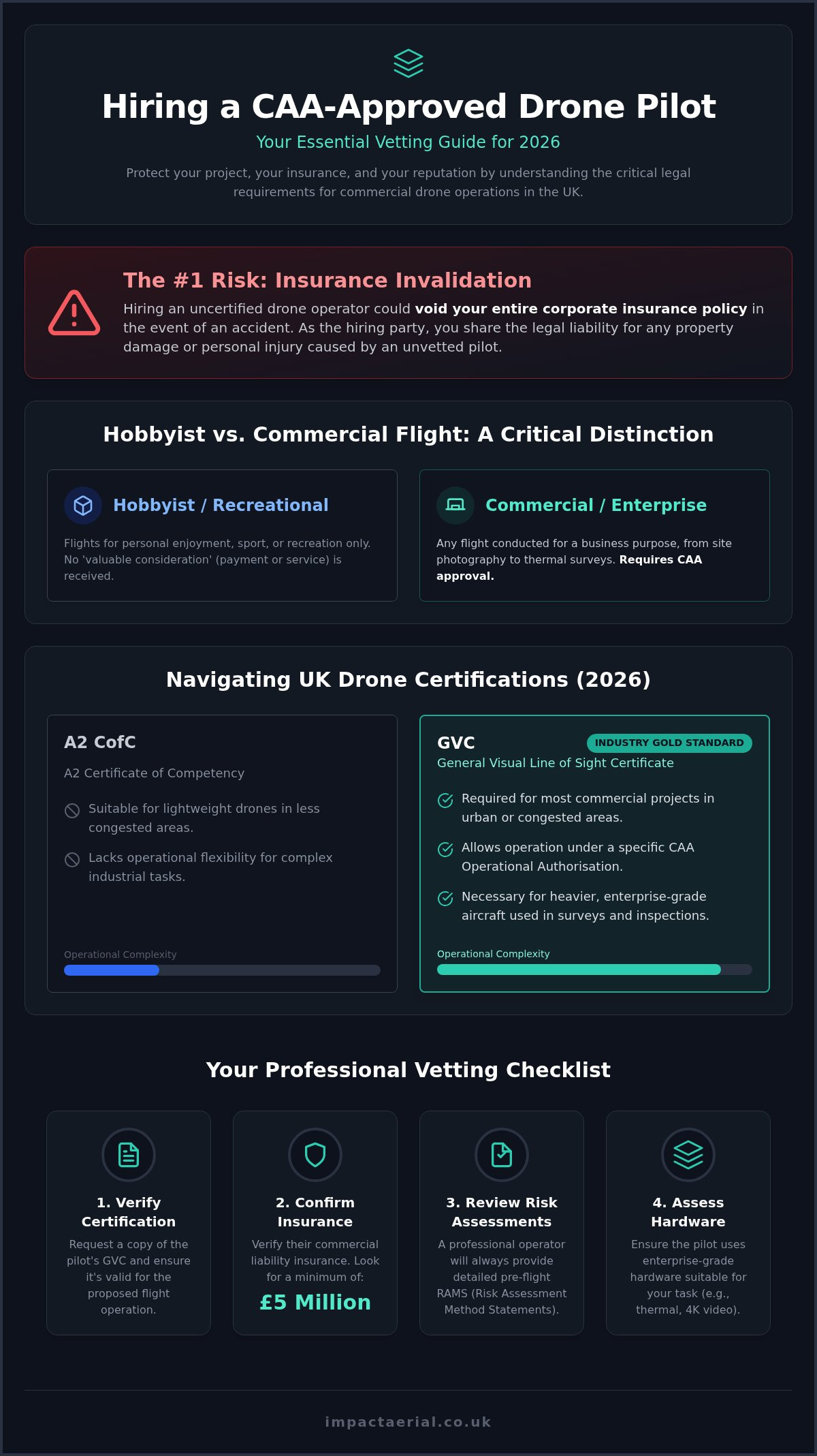
In the United Kingdom, a CAA approved pilot is an operator holding specific permissions and certifications to fly drones for commercial gain. While many people own drones for recreation, the legal distinction between a hobbyist and a commercial operator is strictly defined. If you’re commissioning aerial work for a business, whether it’s a simple site photograph or a complex thermal survey, the flight is classified as commercial. This requires the pilot to hold valid credentials issued by the Civil Aviation Authority (CAA). When you look to hire caa approved drone pilot experts, you’re ensuring that the individual has been vetted for both technical competency and safety knowledge under the current UK drone regulations.
The concept of “Duty of Care” is a significant factor for any project manager or business owner. As the hiring party, you hold a legal responsibility to ensure that any contractor working on your behalf is operating within the law. Hiring an unapproved pilot isn’t just a minor oversight; it’s a breach of safety protocols that can lead to shared liability if an incident occurs. If an unvetted operator causes property damage or personal injury on your site, the legal and financial repercussions often fall back on your organization. Choosing a certified professional mitigates these risks from the outset.
To better understand the professional requirements for operators, watch this helpful video:
The Risks of Using Unlicensed Operators
The Civil Aviation Authority has the power to issue substantial fines and legal penalties to both the pilot and the company that hired them for unauthorized commercial flights. Beyond the immediate financial impact, a drone accident involving an unlicensed operator can severely damage your brand reputation and corporate safety record. Most Tier 1 contractors and large-scale property firms will not permit an unvetted pilot on-site because the risk to their safety standing is too great. CAA approval is the mandatory legal framework for all UK commercial drone flights.
The Critical Link Between Approval and Insurance
The most dangerous trap for businesses is the assumption that a pilot’s insurance is always active. In reality, specialist commercial drone insurance, which must comply with EC 785/2004 standards, is typically contingent on the pilot holding a valid CAA certification. If the pilot lacks the correct license for the task, their insurance is immediately voided, leaving your business fully exposed to any claims. For sectors such as construction and commercial property surveys, £5m liability insurance is the recognized industry standard. Before any work begins, you should meticulously verify the pilot’s insurance certificate and their GVC or A2 CofC credentials to ensure your project remains fully protected and legally compliant.
Navigating UK Drone Certifications: GVC vs. A2 CofC in 2026
Understanding the regulatory framework is the first step toward a compliant mission. The Civil Aviation Authority (CAA) categorises drone operations based on risk, splitting them into ‘Open’ and ‘Specific’ categories. For most commercial projects, the General Visual Line of Sight Certificate (GVC) remains the gold standard. It allows pilots to operate under a specific Operational Authorisation, which is necessary for flying larger enterprise aircraft in urban or congested environments. When you prepare to hire caa approved drone pilot teams, understanding these certification tiers is essential for project safety.
The A2 Certificate of Competency (A2 CofC) is often sufficient for lightweight drones in less congested areas. However, it lacks the operational flexibility required for high-stakes industrial tasks or heavier hardware. You can find a detailed breakdown of these requirements in our guide on the UK Drone License: A Simple Guide to CAA Rules in 2026. To ensure complete compliance, you should always check the CAA’s list of registered operators to verify a pilot’s credentials before they arrive on your site.
When You Need a GVC Certified Pilot
A GVC is mandatory when your project involves flying heavier enterprise drones, such as those used for drone services like complex industrial inspections or large-scale construction site monitoring. These aircraft provide the stability and sensor quality needed for high-accuracy data, but their weight puts them into the ‘Specific’ category. If your site is located in a congested area or requires flight near people, a GVC certified pilot is the only legal choice. It’s the most reliable way to hire caa approved drone pilot experts who can legally manage the complexities of 2026 airspace.
Verifying Operational Authorisation and IDs
Every professional operator should be able to produce an ‘Operational Authorisation’ document. This PDF, issued by the CAA, outlines exactly what the pilot is permitted to do, including flight heights and distances from uninvolved people. You must also verify two specific identification numbers: the Flyer ID, which proves the pilot’s personal competency, and the Operator ID, which identifies the person or business responsible for the drone. These should be clearly displayed on the aircraft itself. During your initial consultation, ask the pilot to explain how their specific authorisation applies to your site’s geography. A meticulous professional will welcome these questions as a chance to demonstrate their compliance. If you need assistance determining the right certification for your project, our team at Impact Aerial can provide a comprehensive regulatory review.
- Flyer ID: Proves the individual has passed the basic theory and competency tests.
- Operator ID: The registration number for the business entity, linked to their insurance and legal accountability.
- Operational Authorisation: The specific permission document that allows for commercial work in the ‘Specific’ category.
Beyond the License: Technical Hardware and Industry Standards
Professionalism in the drone industry isn’t just about the pilot’s license; it’s about the precision of the hardware they deploy. A professional drone platform is a sophisticated data acquisition tool, far removed from the consumer models found in retail stores. When you hire caa approved drone pilot teams, you expect results that meet strict corporate standards, which often requires the use of DJI Enterprise aircraft. These systems offer enhanced flight stability, redundant safety controllers, and specialized sensors designed for the rigorous demands of the property and building sectors.
Matching the equipment to the specific project task is crucial for achieving high-end results. While a standard 4K HDR camera is perfect for creative aerial filming, it may lack the geometric precision required for a detailed structural survey. Enterprise-grade sensors differ from consumer drone cameras because they offer significantly higher data precision, larger sensor sizes for better low-light performance, and mechanical shutters to eliminate distortion during high-speed mapping. This technical distinction ensures that the data you receive is accurate and fit for purpose.
Before any mission begins, a professional operator must ensure all hardware is correctly registered and maintained. You can review the current CAA drone registration requirements to understand the identification standards every commercial aircraft must meet. This technical compliance ensures that the data collected is not only high-quality but also legally defensible in a corporate environment.
Industry-Specific Drone Requirements
Construction site monitoring requires more than just occasional photography. It demands consistent GPS-tagged imagery and 3D mapping capabilities to track project progress against architectural models. Similarly, commercial property surveys focus on capturing high-detail roof and façade data safely, often using high-magnification zoom lenses to inspect defects from a safe standoff distance. For a deeper look at these technical methodologies, read our Drone Survey: The Complete Guide to Aerial Data Collection.
Specialist Capabilities: Thermal Surveys and Virtual Tours
Specialized tasks like PV Solar Farm Thermal Surveys require radiometric thermal sensors. These sensors don’t just show heat signatures; they record temperature data for every individual pixel, allowing for the precise identification of faulty cells or failing strings. For property marketing, we use 360-degree aerial capture to create immersive virtual tours, providing a comprehensive perspective of a property’s location and surroundings. To achieve these results, you must hire caa approved drone pilot specialists who possess the post-production expertise to turn raw sensor data into actionable reports. Actionable insights are the true value of professional drone work, moving beyond simple imagery to provide tangible business intelligence for your stakeholders.
The Professional Workflow: What to Expect On-Site
A professional drone operation is a structured sequence of technical events designed to maximize safety and data quality. When you hire caa approved drone pilot teams, you aren’t just paying for the flight time; you’re investing in a comprehensive safety and data management workflow. This meticulous process begins long before the aircraft leaves the ground, ensuring that every mission is compliant with UK aviation law and your specific project requirements.
- Step 1: Initial Consultation and Feasibility: We analyze the flight location to ensure the mission goals are legally and technically achievable within the current airspace.
- Step 2: Pre-flight Site Assessment: A detailed desk-based survey of the area identifies permanent hazards and land ownership requirements.
- Step 3: Airspace Coordination: We check for temporary restrictions and, if necessary, obtain NOTAMs (Notice to Airmen) to alert other aircraft in the vicinity.
- Step 4: On-site Execution: The pilot follows strict safety protocols, including real-time weather monitoring and site cordoning.
- Step 5: Data Processing: Raw sensor data is transformed through post-production into final 4K video, 3D models, or thermal reports.
This structured approach ensures that the high-end results you require are delivered without exposing your business to liability. If you’re ready to begin your mission, contact us for a professional drone project consultation today.
Pre-Flight Risk Assessment (RAMS) Explained
The Risk Assessment and Method Statement (RAMS) is the cornerstone of a safe commercial flight. This document identifies specific hazards such as overhead power lines, uninvolved people, and sensitive buildings. For every identified hazard, we implement clear mitigation strategies, which may include the use of visual observers (spotters), physical cordons, and established emergency procedures. A pilot who cannot or will not provide a detailed, site-specific risk assessment is a major red flag. It suggests a lack of professional oversight that could invalidate their insurance and put your site at risk.
Managing Airspace Restrictions and Weather
Safe flight is heavily dependent on environmental conditions and airspace permissions. Professional pilots monitor wind limits and precipitation constraints constantly; enterprise drones have specific tolerances that must never be exceeded. We also manage the complexities of Flight Restriction Zones (FRZs) near airports and military sites, which require specific coordination with Air Traffic Control. This level of technical planning is essential for high-stakes work. For projects focusing on visual storytelling, you can learn more about these technical requirements in our guide to Aerial Filming Drone: The Ultimate Guide to Professional Cinematic Video. By managing these variables, we ensure a seamless project execution from start to finish.
Partnering with Impact Aerial for Your UK Drone Project
Impact Aerial provides a streamlined solution for businesses looking to hire caa approved drone pilot specialists who prioritize regulatory compliance and technical precision. Based in Birmingham, our team operates nationwide, bringing local West Midlands expertise to high-stakes projects across the UK. We maintain a meticulous focus on safety, backed by £5m in commercial liability insurance and a roster of CAA GVC certified pilots. This level of professional coverage provides total psychological comfort for our clients, ensuring that every aerial mission is fully insured and legally compliant with the standards we’ve outlined in this guide.
Our capabilities span a diverse range of sectors, including commercial property, large-scale construction, and specialized energy infrastructure. Unlike a standard directory or hobbyist operator, we provide end-to-end project management. We don’t just capture data; we translate it into actionable business intelligence through our high-end post-production services. Whether you require precise thermal data for a solar farm or cinematic 4K footage for a national advertising campaign, our workflow is designed to deliver excellence without compromise.
Expertise in Visual and Technical Data Collection
Our operational experience ranges from creative cinematic filming projects to technical PV solar farm thermal surveys. We handle the entire project lifecycle, managing every detail from the initial feasibility consultation to the delivery of the final assets. By utilizing the latest DJI Enterprise technology, we ensure that every flight captures the highest possible level of detail, whether that’s radiometric thermal data or high-resolution structural imagery. Our commitment to using industry-leading hardware means your data is consistently accurate and suitable for professional analysis. You won’t have to worry about the technicalities of sensor calibration or flight permissions; our team manages the entire process.
The Impact Aerial Difference: Safety, Scale, and Quality
At the heart of our business is a safety-first culture that places your project’s compliance above all else. We understand that your corporate safety record is paramount, so we integrate the rigorous risk mitigation strategies discussed earlier into every stage of our process. Impact Aerial is a trusted specialist in the West Midlands and beyond, known for maintaining transparent pricing and clear communication throughout the hiring process. We avoid the ambiguity often found in the drone industry, providing you with a reliable partner that understands the nuances of 2026 aviation standards. When you choose to hire caa approved drone pilot experts from our team, you’re securing a partner dedicated to delivering high-tier quality and absolute operational reliability for your business.
Securing Your Project’s Future with Professional Drone Data
Navigating the complexities of UK aviation law ensures your project remains protected and productive. By prioritizing legal compliance and technical precision, you eliminate the risks associated with unauthorized flights and voided insurance policies. You now understand that verifying GVC certifications and ensuring comprehensive liability coverage are the most critical steps when you look to hire caa approved drone pilot specialists. Whether you require high-accuracy thermal data for solar farms or detailed structural surveys, the right partner manages the regulatory burden so you can focus on actionable insights.
Impact Aerial stands ready to support your mission with CAA GVC Certified Pilots and £5m Commercial Liability Insurance. Based in Birmingham, we provide expert aerial services across the entire UK, utilizing advanced DJI Enterprise hardware to deliver superior results for the property and construction sectors.
Request a Professional Drone Consultation from Impact Aerial today to ensure your next project is safe, compliant, and technically flawless. We look forward to helping you reach new perspectives with confidence.
Frequently Asked Questions
Is it illegal to hire a drone pilot without a CAA licence in the UK?
It is a breach of UK aviation law to hire an unlicensed operator for commercial gain. Both the pilot and the hiring organization can face significant legal penalties and fines from the Civil Aviation Authority if an unauthorized flight is conducted. Beyond the legal risk, using an uncertified operator typically voids any insurance coverage, leaving your business fully liable for any damages or injuries that occur during the flight.
How much does it cost to hire a professional drone pilot for a day?
Professional day rates vary significantly based on the technical complexity of the task and the specialized hardware required for the mission. A high-end thermal survey using radiometric sensors for a solar farm will command a different rate than a standard architectural photography session. Clients should request a project-specific quote that includes pre-flight planning, site assessments, and post-production data processing to ensure a transparent breakdown of costs.
Can a drone pilot fly in a restricted area or near an airport?
Qualified pilots can operate in Flight Restriction Zones (FRZs) and other restricted airspaces, provided they have the correct Operational Authorisation and coordinate directly with Air Traffic Control. This process involves filing a flight plan and obtaining a specific permit for the mission. When you hire caa approved drone pilot experts, they manage these complex permissions and NOTAM filings as part of their professional service.
What insurance should a professional drone pilot have for commercial work?
A professional operator must carry specialist commercial drone insurance that is compliant with EU Regulation (EC) 785/2004. For industrial sectors like construction and commercial property, a minimum of £5m public liability insurance is the recognized industry standard. You should always request to see a valid insurance certificate before any work commences to ensure your organization is fully protected against third-party claims.
What is the difference between an A2 CofC and a GVC qualification?
The A2 Certificate of Competency (A2 CofC) allows for lower-risk flights with smaller drones, while the General Visual Line of Sight Certificate (GVC) is the professional standard for complex commercial operations. A GVC is required for pilots using heavier enterprise aircraft in congested areas or near people. It serves as the prerequisite for obtaining a specific Operational Authorisation from the CAA, which is essential for high-level industrial tasks.
What happens if a drone pilot crashes on my property during a shoot?
If a crash occurs, a professional pilot’s commercial liability insurance should cover the resulting property damage or personal injury. The pilot must have followed the pre-flight risk assessment and mitigation strategies outlined in their RAMS document for the insurance to remain valid. This is why verifying a pilot’s CAA credentials and insurance status is the most critical step when you hire caa approved drone pilot teams for your site.
Do I need to notify my neighbours before hiring a drone pilot?
There is no strict legal requirement to notify neighbors in every scenario, but it is considered best practice to inform adjacent property owners to manage privacy concerns. Professional pilots adhere to strict GDPR and privacy guidelines, ensuring that data is only collected for the intended project scope. A thorough pre-flight assessment will identify any sensitive areas, and the pilot will implement cordons or flight path adjustments to respect surrounding boundaries.
How do I verify if a drone pilot is actually CAA approved?
You can verify an operator’s status by requesting their CAA Operational Authorisation document and checking their unique Operator ID. This document lists the pilot’s permissions, the aircraft they are authorized to fly, and the validity dates of their certification. A legitimate professional will always be able to provide these documents alongside their GVC certificate and proof of insurance during the initial consultation phase.
 2 Norton Drive, Wythall, Birmingham, B47 6HH Company registration number: 11138586. VAT Number: 366 9068 55


