
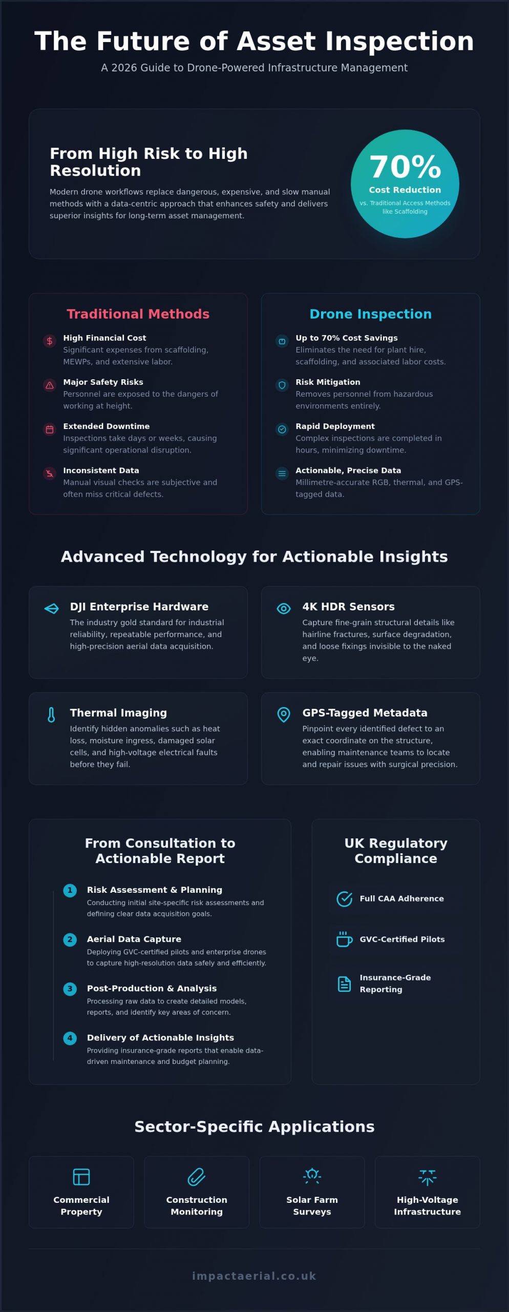
Did you know that modern drone asset inspection can reduce your survey costs by as much as 70% when compared to traditional scaffolding and high-access equipment? For many UK facility managers, the financial burden of plant hire and the safety risks of personnel working at height are constant, expensive headaches. You’ve likely struggled with inconsistent data from manual visual inspections that leave your long-term maintenance planning in a state of guesswork.
We agree that structural integrity and site safety shouldn’t be a compromise. This 2026 industry guide reveals how professional drone asset inspection provides millimetre-accurate RGB and thermal data while maintaining full CAA compliance and risk mitigation. You’ll learn how to eliminate inspection downtime and leverage high-resolution advanced drone technology to generate actionable insights for your infrastructure. We’ll examine the latest UK class marking mandates, the importance of GVC-certified pilots, and how to integrate high-tier data into your maintenance strategy. By the end of this guide, you’ll understand how to transition from basic aerial photography to a rigorous, data-centric approach that protects both your budget and your assets.
Key Takeaways
- Learn how transitioning from traditional access methods to UAV workflows can reduce inspection costs by up to 70% while eliminating the safety risks associated with working at height.
- Understand the critical role of DJI Enterprise hardware and 4K HDR sensors in capturing the millimetre-accurate structural data required for insurance-grade reporting.
- Navigate the 2026 UK regulatory landscape, ensuring your drone asset inspection remains fully compliant with Civil Aviation Authority (CAA) GVC standards and insurance requirements.
- Discover sector-specific applications for construction site monitoring and commercial property surveys that provide high-resolution thermal and RGB data for maintenance planning.
- Explore the end-to-end operational workflow, from initial site-specific risk assessments to the delivery of actionable post-production data.
What is Drone Asset Inspection and Why is it Essential in 2026?
Professional drone asset inspection is a sophisticated remote sensing methodology that replaces traditional, high-risk manual surveys with precise aerial data acquisition. By deploying an Unmanned aerial vehicle (UAV) equipped with high-specification sensors, surveyors can capture comprehensive visual data without the logistical burden of scaffolding or Mobile Elevated Work Platforms (MEWPs). This technological leap is essential for modern infrastructure management. It allows for rapid emergency structural assessments and the implementation of robust preventative maintenance schedules that were previously cost-prohibitive.
The Shift from Manual to Digital Asset Management
The year 2026 represents a definitive tipping point for the UK’s industrial landscape. We’ve moved beyond simple aerial photography into an era of semi-autonomous workflows and digital twins. Utilizing high-end DJI Enterprise hardware is now the industry benchmark. These systems use 4K HDR imagery to document structural integrity with surgical precision. This digital-first approach removes the need for personnel to work at height, significantly reducing site-side liability. By capturing fine-grain detail from a safe distance, we ensure that every bolt, weld, and surface texture is accounted for in a secure, repeatable manner.
Key Benefits: ROI, Safety, and Data Fidelity
The financial argument for aerial surveys is undeniable. Industry data indicates that switching to drone-based workflows can reduce inspection costs by up to 70% compared to traditional access methods. This saving is largely achieved by eliminating the weeks of labour required to erect and dismantle scaffolding. Beyond the balance sheet, the data fidelity provided by professional sensors is superior to manual visual checks. Drones identify critical defects such as micro-cracks, early-stage corrosion, and thermal leaks that the human eye often misses from a distance.
- Reduced Downtime: Inspections that once took days are now completed in hours.
- Historical Records: Each flight creates a timestamped visual baseline for long-term asset monitoring.
- Risk Mitigation: Full CAA GVC compliance ensures that operations are conducted within the strictest safety frameworks.
Technical Capabilities: Sensors, Thermal Imaging, and DJI Enterprise Hardware
Commercial-grade DJI Enterprise drones represent the current gold standard for drone asset inspection. These systems aren’t consumer-grade toys; they’re high-precision instruments built for industrial reliability and repeatable performance. We utilize 4K HDR sensors because they capture the fine-grain structural detail necessary to identify hairline fractures, surface degradation, or loose fixings that traditional visual checks might overlook. Every frame captured is embedded with GPS-tagged metadata. This allows our team to map assets with surgical precision, ensuring that every identified defect is linked to an exact coordinate on the structure for your maintenance teams to locate and repair.
Thermal Camera Drones for Asset Integrity
Thermography is the science of using infrared sensors to detect heat signatures and temperature variations on an asset’s surface. In the context of asset health, it’s an essential tool for identifying anomalies before they escalate into catastrophic failures. Our PV solar farm thermal surveys use these specialized sensors to pinpoint ‘hot spots’, such as damaged cells or faulty string connections, that remain invisible to the naked eye. This technology is equally effective for identifying heat loss in commercial roofing or electrical faults in high-voltage infrastructure. Adhering to the UK’s regulatory framework for drones is vital here, as industrial thermal work often requires specific operational clearances when flying near complex plant machinery or in congested areas.
3D Modelling and Digital Twins
Raw data only becomes valuable when it’s actionable for your engineers and stakeholders. We convert aerial datasets into immersive 3D models and digital twins that allow you to inspect assets from the safety of your desk. These models provide a comprehensive view of remote or high-access structures, facilitating better collaborative decision-making and precise measurements. If you’re wondering what is a survey drone in a technical sense, it’s essentially a flying data-collection hub capable of millimetre-accurate reconstruction. Our virtual tour creation service further enhances this by providing a 360-degree perspective of your site. This level of data fidelity is a cornerstone of our drone commercial property surveys, ensuring that your maintenance planning is based on high-resolution evidence rather than guesswork.
UK Compliance and Safety: The Regulatory Framework for Asset Managers
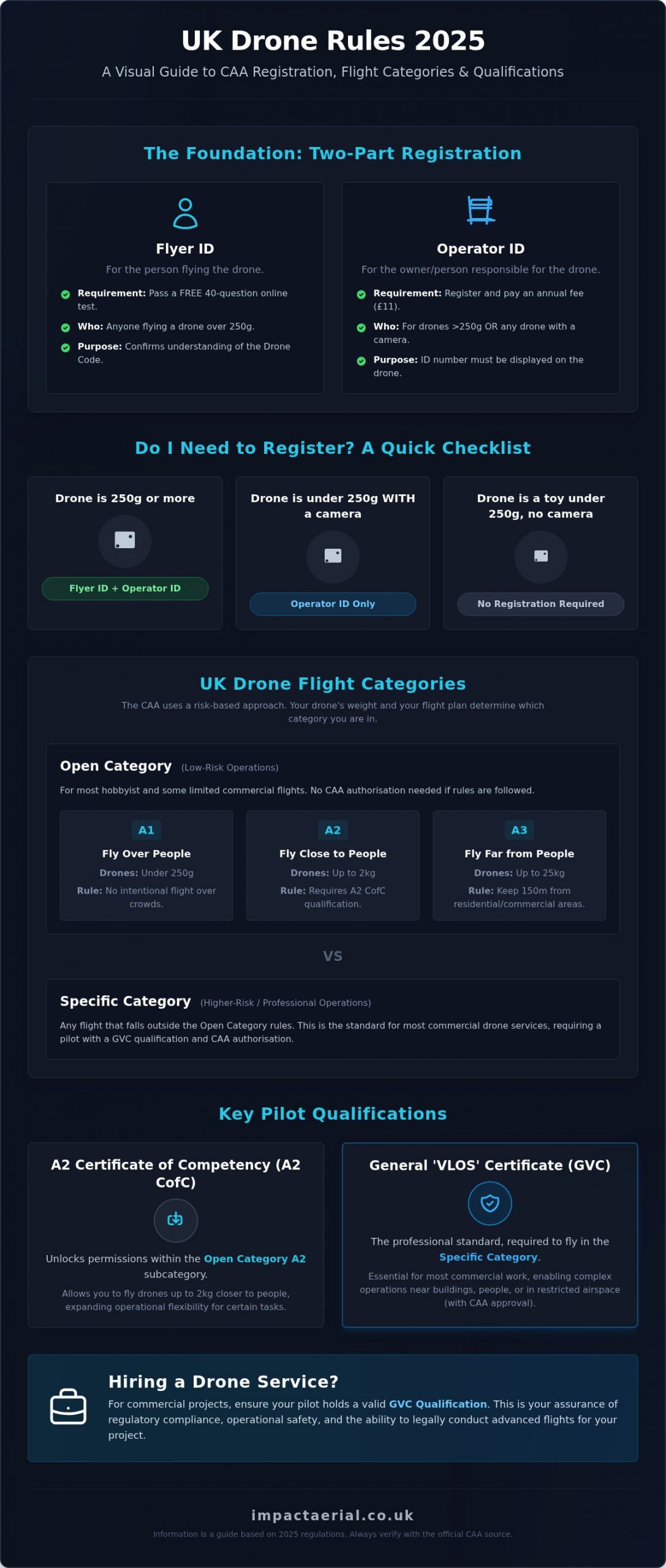
Legality isn’t just a box-ticking exercise; it’s a fundamental pillar of structural risk management. For any professional drone asset inspection, the General Visual Line of Sight Certificate (GVC) from the Civil Aviation Authority (CAA) is non-negotiable. This certification demonstrates that the pilot has undergone rigorous theoretical and practical testing to handle complex aircraft in commercial environments. Operating without these credentials doesn’t just void insurance; it exposes the asset manager to significant legal liability under the Air Navigation Order.
Flying in congested UK areas, such as city centres or busy industrial estates, requires a deep understanding of the specific permissions granted by the CAA. We manage these complexities through site-specific Risk Assessment Method Statements (RAMS) and comprehensive pre-flight surveys. These documents outline every potential hazard, from localized magnetic interference to public right-of-way management. To provide complete peace of mind, we carry £5m commercial liability insurance as standard. This ensures that your assets and personnel are fully protected against unforeseen incidents during the survey.
Vetting Your Drone Service Provider
Asset managers must be meticulous when selecting a partner. Always ask for a copy of the pilot’s Flyer ID and GVC certification, and verify that their insurance specifically covers the type of asset being inspected. If you’re unsure about the current requirements, our UK drone license guide provides a clear breakdown of the rules in 2026. Checking these credentials ensures you’re working with a vetted professional who understands the gravity of industrial safety standards. We recommend verifying these documents at the start of the procurement process to avoid project delays.
Operational Safety in High-Risk Environments
Inspecting live construction sites or active industrial zones presents unique challenges. Safety is maintained through clear communication with site managers and the use of a dedicated ‘Observer’ for complex structural flights. This second person monitors the surrounding airspace and ground hazards, allowing the pilot to focus entirely on the precision flight path. We also prioritize data privacy. Every drone asset inspection is conducted in strict accordance with GDPR, ensuring that images of the public or third-party properties are handled or redacted appropriately to maintain compliance. This meticulous approach to safety and privacy is what separates professional operators from hobbyists.
Sector-Specific Applications: Where Drone Asset Inspection Excels
The versatility of professional drone asset inspection allows it to deliver value across a broad spectrum of UK industries. While the core technology remains consistent, the specific data outputs are tailored to the unique requirements of each sector. From high-resolution visual reporting for RICS surveyors to complex thermal mapping for energy providers, the application of aerial technology is transforming how structural health is monitored. Within the transport and logistics sector, this precision data often works in tandem with the safety standards upheld by DVSA Auditors, who help fleet operators achieve regulatory compliance. It provides a non-invasive way to examine high-value assets, ensuring that maintenance budgets are allocated based on empirical evidence rather than scheduled guesswork.
In the construction sector, drones provide a continuous stream of data from site inception to completion. We use DJI Enterprise drones for initial land surveys and topographic mapping, providing a digital foundation for architects and engineers. For a deeper dive into these methodologies, see our drone survey guide. Beyond the technical data, we often capture high-end cinematic marketing shots during the same site visit. This dual-purpose workflow provides project managers with progress reports and safety compliance records while simultaneously creating promotional assets for stakeholders. For property managers, this means having a comprehensive visual record of roof condition and facade integrity without the logistical burden of plant hire.
Renewable Energy and Industrial Assets
The renewable energy sector benefits significantly from specialized aerial sensors. Thermal mapping for large-scale PV solar installations allows us to identify defective panels and string failures across hundreds of acres in a single day. This level of efficiency is impossible to match with handheld thermography. Similarly, for heavy industrial assets like flare stacks, cooling towers, and chimneys, the role of drone asset inspection is critical because it allows for close-quarters examination without requiring a facility shutdown. In dense industrial environments where visual lines are obscured, LiDAR sensors provide the necessary penetration to map complex pipework and structural supports with centimetre-level accuracy. Bridges and telecommunications towers are also inspected with minimal disruption to traffic or operations, ensuring that critical UK infrastructure remains safe and functional.
If you’re looking to optimize your maintenance programme and reduce operational risk, our team provides comprehensive drone commercial property surveys and industrial inspections across the UK.
The Impact Aerial Workflow: From Consultation to Actionable Reporting
Every professional drone asset inspection begins with a technical consultation to define the scope and structural objectives of the project. We don’t just launch aircraft; we align our flight paths with your specific maintenance requirements. This consultative phase ensures that the data we capture is relevant to your engineers and insurance providers. By defining clear goals at the start, we eliminate redundant data capture and focus on the high-value areas of your infrastructure.
Our mission planning phase is where our safety-first philosophy becomes tangible. We conduct a meticulous review of local airspace restrictions and create site-specific Risk Assessment Method Statements (RAMS) for every deployment. This rigorous preparation allows us to operate in complex industrial environments with the confidence that all risks are mitigated. During the flight, our GVC-certified pilots use high-end DJI Enterprise technology to capture 4K HDR imagery. This hardware is chosen for its reliability and its ability to maintain stable positioning in challenging weather conditions common to the UK.
Data Processing and Technical Reporting
Raw footage is only the beginning of the workflow. Our post-production team processes the data to create comprehensive, annotated reports that highlight structural anomalies. We use specialized software to identify and label defects, providing a clear visual record that your team can use for maintenance planning. The role of post-production is to distill thousands of high-resolution images into a manageable, actionable format. This data is delivered through secure, cloud-based platforms. It’s accessible to all stakeholders instantly, allowing for collaborative decision-making without the need for large file transfers or physical storage.
Regional Expertise: Why Birmingham-Based Deployment Matters
Being based in Birmingham gives us a unique advantage for UK-wide operations. We’re situated at the heart of the country’s transport and logistics network, allowing for rapid response times to projects in the West Midlands and beyond. This central location means our team understands the specific airspace complexities of the Midlands hub, from busy urban centres to active industrial corridors. Whether you require a single roof survey or a national programme of site monitoring, our regional expertise ensures a seamless service. We’re proud to support the UK’s infrastructure with meticulous, compliant, and technologically adept aerial solutions.
Ready to secure your infrastructure and reduce your operational risks? Contact Impact Aerial for a professional asset inspection quote today.
Future-Proofing Your UK Asset Management Strategy
As the UK infrastructure landscape evolves through 2026, adopting a data-centric approach to structural health is a strategic necessity. By integrating professional drone asset inspection into your maintenance cycles, you eliminate the safety risks of working at height and replace subjective visual checks with millimetre-accurate evidence. This transition ensures that every pound spent on maintenance is backed by high-resolution 4K HDR and thermal data. It’s a safer, more efficient way to manage large-scale assets.
Impact Aerial provides a complete end-to-end solution for asset managers nationwide. Our team of CAA GVC Certified Pilots carries £5m Liability Insurance as standard, ensuring your project is handled with the highest level of professional oversight and compliance. We include Full Post-Production Reporting with every survey, delivering the actionable insights you need to protect your commercial assets and long-term budget.
Request a Professional Drone Asset Inspection Quote from Impact Aerial.
Take the first step toward a safer, more efficient inspection workflow today.
Frequently Asked Questions
Is drone asset inspection legal in the UK?
Yes, provided the operator adheres to Civil Aviation Authority (CAA) regulations. Commercial work requires specific certifications, such as the GVC (General Visual Line of Sight Certificate), and valid specialist insurance. Operators must also ensure their hardware complies with the 2026 class marking mandates. Following these legal frameworks ensures your data is valid for official structural reports and insurance claims.
What is the difference between a standard drone and an inspection-grade drone?
Inspection-grade drones, such as DJI Enterprise models, feature specialized sensors and redundant safety systems that consumer drones lack. They offer 4K HDR visual clarity, thermal imaging, and RTK (Real-Time Kinematic) positioning for centimetre-level accuracy. Standard drones are built for creative photography, whereas enterprise hardware is designed for industrial reliability, repeatable flight paths, and high-fidelity data acquisition in complex environments.
How much does a drone asset inspection cost?
The cost of a professional drone asset inspection varies based on the site’s size, the complexity of the structure, and the type of data required. Factors such as the need for thermal sensors or 3D modelling influence the final project scope. While we don’t provide fixed pricing without a consultation, the efficiency of aerial surveys typically results in a 30% to 70% saving compared to traditional scaffolding.
What qualifications should a drone pilot have for asset inspection?
A professional pilot must hold a CAA GVC (General Visual Line of Sight Certificate) for commercial operations in the UK. This qualification proves they have the technical knowledge and flight proficiency to manage aircraft in industrial areas. Additionally, pilots should have specialized training in data processing and thermography for structural health surveys. Always verify their Flyer ID and insurance status before deployment.
Can drones perform inspections in bad weather or high winds?
High-end DJI Enterprise drones are built with high wind resistance, often up to 12 or 15 metres per second, but safety remains the priority. We don’t fly in heavy rain or gale-force winds as these conditions compromise data quality and operational safety. Our pilots monitor localized weather data constantly. If conditions are unsuitable, we reschedule the flight to ensure the resulting structural imagery is clear.
How accurate is the data from a drone inspection?
When using RTK-enabled hardware, the data is accurate to within a few centimetres for positioning and can provide millimetre-level detail for structural defects. This precision allows engineers to identify hairline cracks or micro-corrosion that would be missed by the naked eye. High-resolution 4K HDR sensors ensure every pixel represents a tangible part of the asset, making the reporting valid for rigorous maintenance planning.
Do I need to shut down my site during a drone inspection?
No, one of the primary benefits of a drone asset inspection is that it can usually be conducted while your site remains fully operational. Because drones operate from a distance, they don’t interfere with ground-level workflows or machinery. We coordinate with site managers to establish a safe take-off and landing zone. This non-invasive methodology eliminates the costly downtime required for traditional manual inspections or scaffolding assembly.
What kind of insurance does a drone inspection company need?
Commercial drone operators in the UK must carry specialist public liability insurance that is compliant with EC Regulation 785/2004. At Impact Aerial, we maintain £5m in commercial liability insurance to protect our clients’ interests. This coverage is essential for working on high-value infrastructure or in congested urban environments. It provides the necessary financial reassurance that your assets and personnel are fully protected during the survey.
 2 Norton Drive, Wythall, Birmingham, B47 6HH Company registration number: 11138586. VAT Number: 366 9068 55


