Hire Professional Drone Photographer: The 2026 Guide to UK Aerial Services

What if the “affordable” drone pilot you just booked doesn’t actually have the legal right to fly near your commercial premises? You’re likely aware that high-resolution aerial data is no longer a luxury; it’s a competitive necessity for everything from construction site monitoring to PV solar farm thermal surveys. However, with the 2026 UK drone regulations now in full effect, the gap between a hobbyist and a certified expert has never been wider. It’s why more businesses now choose to hire professional drone photographer services that prioritize technical precision and risk mitigation over basic flight.

You shouldn’t have to worry about legal liability for non-compliant flights or hidden post-production costs that blow your budget. This guide will show you exactly how to secure 4K HDR imagery while ensuring total CAA compliance, including the latest Remote ID and UK class marking requirements. We’ll explore the critical steps to seamless project management, from initial flight planning and mandatory night-flying green lights to the final post-production edit. Discover how to leverage professional aerial filming and photography to gain a clear, compliant, and technically superior perspective on your next commercial project.

Key Takeaways

  • Understand the critical legal distinction between hobbyist flights and commercial operations to protect your business from shared liability under 2026 UK regulations.
  • Learn why enterprise-grade hardware featuring mechanical shutters and 4K HDR sensors is mandatory for high-precision technical surveys and commercial property marketing.
  • Use our professional checklist to verify a pilot’s CAA GVC status and Operational Authorisation before you hire professional drone photographer experts for complex urban projects.
  • Explore how specialized aerial data, from PV solar farm thermal surveys to construction site monitoring, provides measurable ROI and technical clarity for stakeholders.
  • Discover the importance of a structured workflow that integrates meticulous flight planning with high-tier post-production services for a seamless project delivery.

Why Hiring a Professional Drone Photographer is Essential in 2026

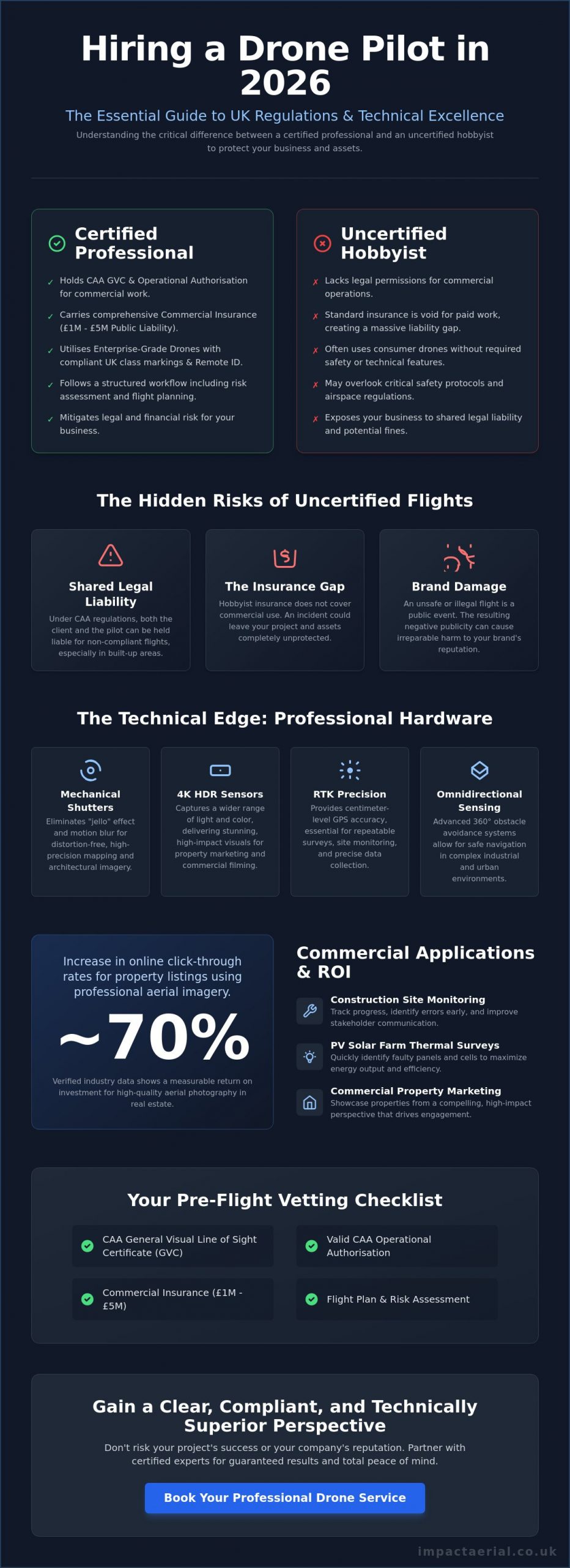
The decision to hire professional drone photographer services is no longer just about capturing a unique angle; it’s a fundamental requirement for corporate risk management. In 2026, the distinction between a hobbyist and a commercial operator is defined by strict regulatory compliance and technical capability. While the history of aerial photography began with tethered balloons and rudimentary cameras, modern operations involve sophisticated systems like Remote ID and UK class markings. These technical layers ensure that every flight is accountable to the Civil Aviation Authority (CAA), providing a level of transparency and safety that hobbyist flights simply can’t match.

To better understand the visual impact of professional aerial work, watch this helpful video:

Commercial projects carry inherent risks that a casual pilot isn’t equipped to handle. Since January 1, 2026, all new drones must carry specific UK class markings, from UK0 to UK6, which dictate where they can fly and their proximity to the public. If you hire professional drone photographer experts who use “legacy drones” without the proper Operational Authorisation for urban areas, you aren’t just risking poor results. You’re assuming legal risk. The CAA can hold both the pilot and the client liable for non-compliant flights, particularly in built-up areas where safety protocols are paramount.

The Hidden Risks of Using Uncertified Operators

Uncertified operators often lack the specific insurance required for commercial work. Standard hobbyist policies fail when a drone is used for financial gain, leaving a massive “insurance gap” if an incident occurs. Professional operators carry public liability coverage, often ranging from £1 million to £5 million, to protect your assets and your reputation. Beyond the legal threat, an unsafe flight can cause irreparable damage to your brand’s public image. Meticulous planning is the only way to mitigate these operational dangers.

The Commercial Advantage of Professional Perspectives

Professional aerial filming and photography provide a measurable return on investment. High-resolution 4K HDR imagery can increase online click-through rates for property listings by nearly 70% based on verified industry data. In the industrial sector, construction site monitoring allows project managers to track progress with high precision, potentially shortening project timelines by identifying errors early. The psychological impact of high-end visuals is undeniable. They signal to your clients that you value quality, safety, and technical excellence.

The Technical Edge: What Separates Pro Drone Services from Hobbyists

Technical superiority isn’t just a marketing claim; it’s the foundation of every successful aerial project. When you hire professional drone photographer specialists, you’re paying for enterprise-grade hardware that far exceeds the capabilities of standard consumer models. For example, the DJI Mavic 3 Enterprise series features mechanical shutters. These are essential for eliminating rolling shutter distortion when capturing high-speed architectural data or mapping large sites. Consumer drones often rely on electronic shutters, which can lead to warped imagery that doesn’t meet rigorous technical standards.

Professional equipment provides several critical advantages for commercial clients:

  • Mechanical Shutters: Prevents image “jello” effect during high-speed motion, ensuring crisp architectural lines.
  • RTK Precision: Real-Time Kinematic positioning provides centimeter-level accuracy for repeatable site monitoring.
  • Omnidirectional Sensing: Advanced obstacle avoidance allows for safe navigation in complex industrial environments.
  • Dual-Sensor Payloads: The ability to switch between high-resolution visual and radiometric thermal data on a single flight.

Reliability in the field is equally dependent on flight stability. Professional systems utilize RTK positioning to achieve a level of precision that consumer GPS simply cannot match. This accuracy is critical for repeatable construction site monitoring where images must be captured from the exact same coordinates over several months. Furthermore, these systems operate within the strict safety parameters defined by Civil Aviation Authority (CAA) regulations, ensuring that every flight is both stable and legally compliant.

Commercial-Grade DJI Enterprise Technology

High-resolution 4K HDR sensors are standard for capturing the fine architectural details required in high-end property marketing. However, the true value of enterprise technology lies in specialized applications. For instance, PV solar farm thermal surveys require radiometric thermal cameras to detect micro-cracks and cell failures that are invisible to the naked eye. These enterprise drones also boast superior wind resistance and signal stability, allowing for successful operations in weather conditions that would ground a hobbyist aircraft.

The Professional Project Lifecycle

Managing the lifecycle of a commercial project requires more than basic flight skills. When businesses hire professional drone photographer teams, they’re investing in a structured workflow that prioritizes safety and data integrity. This begins with rigorous pre-flight site assessments and airspace coordination. Once the data is captured, the work transitions to our post-production services. Editing accounts for approximately 50% of the final product quality, transforming raw data into cinematic video or 3D models. If you require a technical partner rather than just a pilot, explore our drone commercial property surveys for comprehensive data delivery.

Hire Professional Drone Photographer: The 2026 Guide to UK Aerial Services

Commercial Applications: From Property Marketing to Technical Surveys

The decision to hire professional drone photographer teams often moves beyond aesthetic appeal into the realm of actionable business intelligence. While the hardware discussed previously provides the foundation, the true value lies in how this technology integrates into specific industry workflows. From high-end residential marketing to complex industrial inspections, professional aerial services offer a level of detail and safety that ground-based methods cannot replicate. Adhering to UK Civil Aviation Authority drone regulations is mandatory for these commercial applications, ensuring that data collection doesn’t compromise public safety or legal standing.

Real Estate and Property Development

In the competitive UK property market, high-resolution imagery is essential for contextualising a building within its wider landscape. Professional pilots capture cinematic “hero shots” that highlight proximity to local infrastructure, green spaces, and transport links. This goes beyond simple photography; it includes creating immersive virtual tours that allow luxury listings to stand out to international investors. For commercial developers, these perspectives are vital for site planning and showcasing the scale of a project to stakeholders before the first brick is laid.

Technical Data and Construction Surveys

Construction site monitoring has been transformed by the ability to track progress from the air over time. Regular aerial flyovers provide project managers with a chronological record of development, helping to identify potential delays or logistical bottlenecks. Using drones for commercial property surveys allows for the identification of structural issues in high-access areas, such as church spires, chimneys, or expansive warehouse roofs, without the need for expensive scaffolding or risky manual inspections.

Industrial inspections also benefit from specialized sensors. Thermal analysis is increasingly used to assess energy efficiency by identifying heat loss in commercial buildings or detecting faults in PV solar arrays. This data-centric approach ensures that maintenance teams can target specific problem areas, reducing operational costs and downtime. In creative advertising, these same technical skills are used to capture sweeping, high-tier visuals for brand campaigns, proving that a meticulous, compliant approach to flight is the key to unlocking both creative and technical success.

The Professional Checklist: How to Vet Your Drone Pilot

Choosing to hire professional drone photographer services requires a shift in mindset from creative procurement to technical vetting. In 2026, the regulatory environment is too complex for casual hires based on a flashy Instagram feed alone. You need a verifiable paper trail that proves competence, legal standing, and operational safety. Vetting is your primary tool for risk management, ensuring that your commercial project remains compliant with national aviation standards while delivering high-tier data.

Understanding CAA Certifications in 2026

The foundational requirement for any commercial operator is their specific certification. While an A2 Certificate of Competence (A2 CofC) allows for basic flights in lower-risk environments, a General Visual Line of Sight Certificate (GVC) is the hallmark of a true professional. A GVC pilot has undergone rigorous practical assessments and is qualified to handle more complex operations. This certification is a prerequisite for obtaining an Operational Authorisation from the CAA, which is mandatory for flights in built-up urban areas or near uninvolved people. A valid UK drone license is non-negotiable; always verify a pilot’s credentials against the official CAA register before signing a contract.

Insurance and Risk Mitigation

Insurance is where uncertified operators frequently fail. Standard public liability policies often specifically exclude aviation activities or contain restrictive clauses that void coverage during commercial work. Professional operators maintain insurance that is strictly compliant with EC 785/2004 regulations. While some entry-level pilots carry £1 million in coverage, the industry gold standard for high-stakes commercial projects is £5 million. This level of protection ensures your business is shielded from significant financial loss in the event of hardware failure or accidental property damage.

Beyond the insurance certificate, a meticulous pilot will provide a comprehensive Risk Assessment and Method Statement (RAMS). This document should detail:

  • Site-specific hazard identification and mitigation strategies.
  • Emergency procedures and “lost link” protocols.
  • Airspace coordination and local authority permissions.
  • Specific hardware and software versions used for the mission.

Finally, examine a recent portfolio for technical consistency rather than just a few “lucky” shots. Look for crisp imagery across the entire frame and balanced exposure in challenging lighting conditions. Professional work should show no signs of rolling shutter distortion or pixelation in 4K HDR outputs. If you are ready to secure a fully vetted and insured partner for your next project, contact us for high-precision aerial filming and photography services across the UK.

Impact Aerial: Your Partner for Precision Drone Photography in the UK

Impact Aerial operates as a specialized technical consultancy rather than a standard creative agency. Based in Birmingham and serving the entire United Kingdom, we provide national coverage for organizations that require absolute regulatory compliance and high-tier visual data. When you decide to hire professional drone photographer specialists, you’re choosing a partner that understands the nuances of the 2026 UK aviation landscape. We don’t just fly; we manage complex aerial operations that prioritize data integrity and site safety.

Our commitment to excellence is reflected in our hardware choices and insurance standards. We utilize the latest DJI Enterprise drone technology, ensuring every mission benefits from RTK precision and high-resolution 4K HDR sensors. This technical foundation is backed by £5 million in commercial liability insurance, which is the industry gold standard for professional operators. This level of coverage provides the reassurance needed when operating near sensitive infrastructure or high-value commercial property. It’s a level of protection that consumer-level pilots simply cannot offer.

The Impact Aerial Difference

Our methodology is built on meticulous planning and adherence to safety-first protocols. Every project begins with a detailed site assessment and airspace coordination, ensuring that all flights are fully compliant with current CAA standards. We offer bespoke solutions tailored to the property, construction, and advertising sectors, providing a seamless transition from raw data capture to final delivery. Our in-house post-production services ensure that the final imagery or 3D models are polished, precise, and ready for stakeholder review. This includes technical color grading for cinematic video and the careful stitching of high-resolution stills for expansive drone commercial property surveys.

Get Started with Your Aerial Project

We provide a structured project lifecycle that values your time and project deadlines. From the initial consultation, we work to understand your specific data requirements, whether you need construction site monitoring or sophisticated virtual tour creation. Our team handles all necessary local permissions and risk assessments, removing the administrative burden from your internal staff. This allows your team to focus on the insights our data provides rather than the logistics of the flight itself.

Our typical project timeline is designed for efficiency, moving from the site flight to the final edit with transparent communication at every stage. We provide tailored quotes that reflect the technical complexity and scale of your mission. Hire Impact Aerial for your professional drone photography today to secure a compliant, expert partner for your next UK aerial project. We’re ready to deliver the high-precision imagery your commercial project demands.

Future-Proof Your Operations with Professional Aerial Intelligence

The landscape of UK aerial services has shifted toward a more structured and accountable model. Choosing to hire professional drone photographer experts ensures your projects benefit from 2026-compliant technology and meticulous risk management. You gain more than just a visual perspective; you secure data accuracy and legal protection that hobbyist operations cannot provide. Whether it’s for PV solar farm thermal surveys or construction site monitoring, the technical requirements of modern industry demand a specialist approach.

Impact Aerial provides the technical edge your business requires. Our CAA GVC Certified Pilots use the latest DJI Enterprise Hardware to deliver high-resolution results across the UK. With £5m Commercial Liability Insurance and specialized Birmingham-based national coverage, we offer the reliability needed for complex commercial missions. We’re proud of our track record in delivering high-precision data that supports informed decision-making.

Book Your Professional Drone Photography Consultation Today to discuss your specific requirements for technical surveys or high-end property marketing. We look forward to helping you achieve a superior perspective on your next project.

Frequently Asked Questions

How much does it cost to hire a professional drone photographer in the UK?

Pricing for aerial services depends on project complexity, location, and the specific technical requirements of the mission. Factors such as the use of specialized thermal sensors for PV solar farm surveys or the need for high-resolution 4K HDR imagery for property marketing will influence the final investment. Most professional operators provide bespoke quotes after an initial consultation to account for airspace coordination and post-production editing needs.

Do I need to get permission from my neighbours for drone photography?

You don’t strictly require permission from neighbours to fly over their property, but you must adhere to privacy laws and Civil Aviation Authority (CAA) regulations. Professional pilots ensure they don’t capture identifiable images of people or private data without consent, following the Data Protection Act 2018. When you hire professional drone photographer services, the pilot conducts a thorough risk assessment to ensure all flights remain respectful and legally compliant.

What happens if the weather is bad on the day of the drone shoot?

Professional pilots monitor weather conditions meticulously and will reschedule if wind speeds or precipitation exceed the safe operating limits of the hardware. Enterprise-grade drones generally have higher wind resistance than consumer models, but operational safety remains the absolute priority. Most professional operators include a weather clause in their agreements to allow for a flexible rescheduling window without financial penalty to the client.

Is it legal to fly drones in London or other major UK cities?

It is legal to fly in major cities, but it requires specific certifications and often an Operational Authorisation from the CAA. Flying in congested urban areas like London involves navigating restricted airspace and maintaining safe distances from uninvolved persons. Professional operators manage all necessary permissions and coordination with local authorities to ensure every urban flight is fully authorized and insured for your peace of mind.

How long does a typical professional drone photography session take?

A standard on-site session usually lasts between one and three hours, depending on the scope of the project. Simple property shots might be completed quickly, while comprehensive construction site monitoring or large-scale commercial property surveys require more time for systematic data capture. This timeframe excludes the essential pre-flight planning and the extensive post-production editing required to deliver high-tier professional assets.

What file formats will I receive for my aerial photos and videos?

Clients typically receive high-resolution JPEG or TIFF files for photography and MP4 or MOV files for video production. For technical projects, we can provide specialized data formats such as RAW files for advanced editing or radiometric thermal data for solar inspections. We ensure all deliverables are compatible with your existing marketing or project management software during the final post-production phase.

Can drones be used for indoor photography or filming?

Drones are highly effective for indoor use provided the space is sufficiently large and the pilot uses aircraft equipped with omnidirectional obstacle avoidance. Indoor filming is ideal for showcasing expansive warehouse interiors or large commercial developments. These flights require exceptional pilot skill and specific safety protocols because GPS signals are often unavailable or unreliable inside large structures.

What is the maximum height a professional drone can fly in the UK?

The legal height limit for drone operations in the UK is 120 meters, which is approximately 400 feet above the earth’s surface. This limit is strictly enforced by the Civil Aviation Authority to prevent conflicts with manned aircraft. If a specific commercial project requires a higher altitude, the operator must apply for a specific exemption or an enhanced Operational Authorisation involving additional safety coordination.

Aerial Site Overview Photography: The Professional Guide to Site Intelligence in 2026

What if the most critical data for your 2026 project planning is currently three years out of date and blurred beyond recognition? You likely recognize that relying on generic satellite imagery often leads to costly planning errors and significant coordination delays. It’s frustrating when you can’t get a clear, real-time view of your assets without worrying about the complexities of UK drone laws or potential trespassing. Utilizing professional aerial site overview photography provides a living dataset that static maps and historical archives simply cannot replicate.

This guide will help you master the technical and regulatory requirements for capturing high-resolution imagery that drives project efficiency and safety. You’ll learn how to navigate the permanent UK drone framework established in January 2026, including the latest Remote ID mandates and UK class markings. We will cover everything from producing 4K HDR imagery for stakeholder presentations to ensuring your operations meet EC 785/2004 insurance standards for total site intelligence. By the end, you’ll understand how to integrate compliant, high-tier visual data into your professional workflows to ensure your projects remain on track and fully transparent.

Key Takeaways

  • Learn why 4K HDR imagery and orthorectification are essential for converting visual data into precise, actionable site measurements.
  • Understand the critical advantages of bespoke aerial site overview photography over outdated satellite data for real-time project decision making.
  • Identify the mandatory 2026 UK compliance standards, including CAA GVC certification and the necessity of £5m public liability insurance for high-risk environments.
  • Master the planning process by defining specific project goals and establishing the ideal frequency for recurring construction site monitoring.
  • Discover how professional site overviews across the UK combine meticulous safety protocols with high-tier data quality to protect your project’s ROI.

What is Aerial Site Overview Photography and Why Does it Matter?

Professional aerial site overview photography represents the transition from static, historical records to dynamic site intelligence. Unlike traditional mapping, this process involves deploying advanced drone platforms to capture bespoke, high-resolution imagery specifically tailored to the current state of a project. It’s not just a photograph; it’s a data-rich asset that provides stakeholders with a comprehensive visual understanding of their assets in real-time. This level of clarity is essential for modern project management where precision is a non-negotiable requirement.

By leveraging these visual datasets, project managers can significantly reduce the requirement for frequent, expensive, and time-consuming site visits. This “site intelligence” allows teams to identify potential hazards, verify contractor progress, and coordinate logistics from a remote office. It’s a precise method for ensuring that every stakeholder is looking at the same, up-to-date reality rather than outdated archives. When everyone has access to the same high-resolution perspective, the risk of miscommunication and planning errors drops significantly.

To better understand the evolution and impact of this technology, watch this helpful overview:

Bespoke Photography vs. Satellite Imagery

The difference in quality between bespoke drone data and satellite imagery is stark. While typical satellite services offer resolutions measured in meters per pixel, professional drone captures achieve sub-centimeter accuracy. This level of detail is critical for orthophotography, where images are geometrically corrected to allow for accurate measurements directly from the photo. Satellite imagery is often years out of date and frequently obscured by cloud cover. Bespoke aerial site overview photography allows you to choose the exact time, weather conditions, and specific low-altitude angles required to highlight critical site features that a vertical satellite orbit simply cannot see. This ensures you’re working with current facts rather than historical approximations.

Key Applications Across the Project Lifecycle

Professional aerial data provides tangible value at every stage of a development. It serves as a single source of truth that evolves alongside the project, supporting various departments from engineering to marketing. The primary applications include:

  • Pre-construction: Aerial surveys are used for initial site planning, baseline environmental assessments, and identifying existing site constraints before any ground is broken.
  • Construction phase: Regular flights facilitate weekly or monthly construction site monitoring. This provides stakeholders with clear, chronological evidence of progress and helps to resolve contractor disputes quickly with visual proof.
  • Post-construction: Once the project is complete, drones capture high-end 4K HDR visuals for commercial property marketing, virtual tours, and final handover documentation to the client.

By integrating these high-tier visual perspectives early in the project lifecycle, firms can ensure a higher standard of safety and operational transparency. It’s an investment in precision that pays dividends through reduced rework and streamlined stakeholder reporting.

The Technical Standards of Professional Site Photography

High-tier sensor technology is the foundation of professional aerial site overview photography. We employ 4K HDR cameras to preserve critical detail in deep shadows and bright highlights. This is particularly vital on active construction sites where reflective materials and dark excavations exist side-by-side. Visual depth serves as a technical requirement for identifying structural anomalies or safety hazards that lower-resolution equipment might miss. Precision is our priority.

Our team utilizes DJI Enterprise hardware to maintain maximum stability and data consistency. These industrial-grade platforms offer superior wind resistance and flight precision compared to consumer models. This hardware reliability allows us to follow UK Civil Aviation Authority (CAA) guidance with total compliance. Capturing high-resolution aerial site overview photography requires a clear understanding of the difference between vertical and oblique perspectives. While vertical shots provide the basis for mapping, oblique angles offer the depth needed for stakeholder visualization.

Understanding Orthorectification and Accuracy

Orthorectification is the technical process of removing lens distortion and the “lean” of tall buildings to create a geometrically correct image. By processing nadir (top-down) imagery through specialized software, we generate a 2D map where every pixel represents a precise coordinate. This step is essential for any drone survey aimed at extracting measurements. Integrating RTK-enabled GPS metadata ensures that these site maps are accurate to within centimeters. This allows for reliable volume calculations and site boundary verification without the need for manual ground-based measurements.

Perspective and Cinematic Angles for Marketing

Vertical maps are excellent for data, but oblique (angled) photography provides the context necessary for stakeholder engagement. These shots highlight how a site interacts with surrounding infrastructure like roads and rail links. We often schedule these captures during “golden hour” to maximize property appeal, using techniques detailed in our guide on the aerial filming drone. This combination of technical data and cinematic perspective ensures your site intelligence serves both engineering and commercial teams. If you require this level of technical precision for your next project, our aerial photography services provide the high-end output required for professional site management.

Compliance and Safety: The UK Regulatory Framework

Safety is the primary concern for any commercial flight operation. In 2026, the legal landscape for drone flights is more structured than ever before. Commissioning professional aerial site overview photography requires a partner who understands the intricacies of the law. It’s not just about getting the shot; it’s about protecting your business from liability and ensuring everyone on site remains safe. Professional operators differentiate themselves through rigorous certification and comprehensive insurance coverage that hobbyists simply don’t possess.

A non-negotiable standard for any construction project is £5m public liability insurance. This level of coverage provides the necessary security for high-value environments and complex infrastructure. In dense urban settings, a standard license isn’t enough. Pilots often require specific Operational Authorization from the CAA to fly closer to people or buildings than standard rules allow. Adhering to UK Civil Aviation Authority regulations ensures that every flight is conducted within a legal framework that prioritizes public safety and data privacy. This meticulousness provides the reassurance that your project remains compliant and fully protected.

CAA Regulations and the GVC Standard

The General Visual Line of Sight Certificate (GVC) is the benchmark for professional competency in 2026. This certification proves that a pilot has undergone formal training and practical assessment. It covers advanced airmanship, meteorology, and emergency procedures. For a deeper look at these requirements, see our UK drone license guide. Every mission begins with a detailed pre-flight risk assessment. This document identifies potential hazards, from overhead power lines to nearby schools, and outlines the specific mitigation steps taken to ensure a safe flight. We don’t leave safety to chance.

Risk Mitigation on Active Construction Sites

We understand that construction sites are busy, high-stakes environments. Our operations are designed to integrate seamlessly without causing delays or disrupting your workforce. We use a structured approach to manage risk during every flight:

  • Exclusion Zones: We establish temporary takeoff and landing areas to keep personnel at a safe distance from the aircraft.
  • Dedicated Spotters: Our team uses visual observers to maintain 360-degree awareness of the airspace and ground activity.
  • Site Coordination: Pilots coordinate directly with site managers before takeoff to confirm active crane movements or scheduled deliveries.
  • Technical Fail-safes: Modern DJI Enterprise drones include multiple sensors for obstacle avoidance and automatic Return to Home (RTH) protocols.

This meticulous approach allows us to deliver high-quality aerial site overview photography while your team remains focused on their work. It’s about providing psychological comfort alongside tangible data. By prioritizing these safety protocols, we ensure that site intelligence never comes at the expense of operational security.

How to Plan a Successful Aerial Site Overview Shoot

Effective planning ensures that aerial site overview photography delivers a tangible return on investment. It’s not enough to simply fly a drone; you must align the flight path with your specific project objectives. Start by defining the scope. Are you looking for cinematic visuals to drive commercial property marketing, or do you require technical imagery for construction site monitoring? This distinction dictates everything from the hardware used to the timing of the flight.

Establish your desired shoot frequency early. A one-off baseline capture provides a vital historical record, but recurring progress shots offer the most value for long-term project management. Coordination with site staff is equally critical. Ensuring the site is ‘photo-ready’ involves clearing unnecessary vehicles or debris that might obscure key features. This meticulous preparation guarantees that the final output is professional and ready for stakeholder review.

Defining Your Visual Requirements

You need to determine the required resolution and identify specific areas of interest (AOIs) before the pilot arrives. High-resolution stills are standard, but you might also require 3D modeling or virtual tour creation for a more immersive site overview. Utilizing professional drone services allows for a more integrated approach to project management. This ensures that the data captured meets the technical needs of your engineering team while also satisfying the visual requirements of your marketing department.

Timing and Environmental Considerations

Weather monitoring is a non-negotiable part of the planning process. High winds or heavy rain don’t just impact safety; they degrade image quality. We monitor local forecasts to choose the optimal window for flight. The time of day is just as important. We aim to avoid long shadows that can hide critical site details, unless a specific ‘golden hour’ look is requested for marketing purposes. For multi-site projects, we prioritize consistent angle replication. This allows stakeholders to compare different locations with a standardized visual perspective, making it easier to track progress across your entire portfolio.

The final step is determining your post-production needs. Do you require RAW files for maximum editing flexibility, or are high-resolution TIFFs and PDF reports more suitable for your internal documentation? We provide a range of post-production services to ensure your aerial site overview photography is delivered in the format that best supports your workflow. If you’re ready to implement a data-driven approach to your next project, explore our professional construction site monitoring solutions to see how we can streamline your operations.

Impact Aerial: Professional Site Overviews Across the UK

Based in Birmingham and providing comprehensive nationwide coverage, Impact Aerial delivers a specialized approach to site intelligence. We recognize that high-resolution visual data is a critical asset for modern project management. Our team doesn’t just capture images; we provide a structured data service that integrates seamlessly into your professional workflow. By combining our regional expertise with a broad operational reach, we ensure that your projects receive consistent, high-tier results regardless of their location in the UK.

The “Impact” difference is rooted in our commitment to meticulous technical standards. We utilize 4K HDR technology to ensure that every aerial site overview photography project results in crisp, actionable data. Beyond the flight itself, we provide extensive post-production services. This includes everything from detailed image editing to the development of immersive virtual tour creation. This end-to-end service model ensures that the data we collect is ready for immediate use in stakeholder presentations or internal progress reviews.

Why Industry Leaders Trust Impact Aerial

Our reputation for excellence is built on a foundation of reliability and technical proficiency. We understand the high-stakes nature of commercial environments and prioritize risk mitigation in every mission. Industry leaders choose us because we provide:

  • Industrial Hardware: We exclusively use commercial-grade DJI Enterprise hardware to ensure flight stability and superior data output.
  • Verified Compliance: Every pilot is CAA GVC certified, operating under strict safety protocols that meet the latest 2026 standards.
  • Comprehensive Protection: We provide the psychological comfort of £5m public liability insurance, a mandatory requirement for most UK construction and infrastructure sites.
  • Technical Focus: Our operations are grounded in a meticulous, data-centric approach that prioritizes precision over flashy visuals.

Get Started with Your Site Overview

Initiating a project with Impact Aerial is a structured and transparent process. We begin with a detailed consultation to assess your site’s specific requirements and any unique operational constraints. Once we’ve established the project scope, our team handles all necessary flight planning and regulatory notifications. After the flight, our post-production team processes the raw data into your required formats, ensuring a smooth transition from capture to delivery. If you’re ready to enhance your project’s transparency and efficiency with professional aerial site overview photography, Contact Impact Aerial for a Professional Quote today.

Elevating Your Site Intelligence for 2026 and Beyond

Professional site management in 2026 demands a level of precision that only bespoke aerial data can provide. You’ve seen how 4K HDR imagery and orthorectified maps replace outdated satellite imagery with real-time site intelligence. By prioritizing technical standards and rigorous planning, your project teams can significantly reduce physical site visits while maintaining total transparency for all stakeholders. This structured approach ensures that every decision is based on current facts rather than historical approximations. It’s about moving beyond simple photos towards a comprehensive, data-driven workflow.

Success in this expanding industry relies on an unwavering commitment to safety and regulatory compliance. Utilizing professional aerial site overview photography ensures that your operations are backed by CAA GVC certified pilots and the security of £5m commercial liability insurance. Using industrial-grade 4K HDR DJI Enterprise equipment, Impact Aerial delivers the high-tier output required for complex urban and industrial environments. We provide the technical expertise and meticulous attention to detail that drives project efficiency and safety across the UK.

Ready to transform your project data into actionable intelligence? Request a Bespoke Site Overview Quote from Impact Aerial and secure the precise insights your project deserves. We look forward to helping you master your site’s visual data and protecting your project’s ROI.

Frequently Asked Questions

What is the difference between aerial photography and a drone survey?

Aerial photography focuses on capturing high-quality visual representations for marketing, stakeholder presentations, or basic progress monitoring. A drone survey is a data-centric process that uses photogrammetry to create 2D or 3D maps with measurable accuracy. While photography provides a clear visual perspective of a project, a survey provides the technical data required for precise engineering and volume calculations. Both services are essential components of modern site intelligence.

How much does professional aerial site overview photography cost in the UK?

Professional fees for aerial site overview photography are structured according to the complexity, duration, and technical requirements of each mission. Costs typically depend on whether you require a short site visit for a handful of high-resolution stills or a full day of cinematic filming and technical mapping. We recommend requesting a bespoke quote to ensure the pricing reflects your specific project requirements and any unique safety constraints involved.

Do I need to notify my neighbors before a drone shoot?

There’s no universal legal requirement to notify neighbors for every flight, but it’s a critical part of our risk assessment process. Adhering to UK GDPR and data privacy regulations means we must ensure that we don’t capture identifiable personal data of individuals outside the site boundary. We often advise clients to inform local residents as a matter of professional courtesy to maintain positive community relations during the project.

Can drones fly over active construction sites in urban areas?

Flights over active urban construction sites are permissible provided the operator holds the correct permissions from the aviation authorities. Professional pilots utilize specific Operational Authorisation to manage the increased risks of built-up environments. This involves establishing strict exclusion zones and using dedicated spotters to ensure the aircraft remains a safe distance from personnel and third-party property at all times during the operation.

How often should I have site overview photos taken for progress monitoring?

The frequency of progress monitoring depends on your project’s specific milestones and the pace of structural change. High-intensity builds often benefit from weekly captures to track rapid developments and logistical shifts on the ground. For larger infrastructure projects with longer timelines, monthly site overviews are usually sufficient to provide stakeholders with an accurate and reliable chronological record of the project’s progress.

What file formats will I receive for my site overview?

You’ll receive your final data in formats that best suit your internal professional workflows. We typically provide high-resolution JPEGs or TIFFs for presentations and RAW files if your team requires maximum editing flexibility in post-production. For technical site reports or 3D modeling, we deliver PDF summaries and industry-standard data files that are fully compatible with most modern CAD and BIM software platforms.

How long does a typical aerial site overview shoot take?

A standard mission for aerial site overview photography typically requires between one and four hours on-site. The exact duration depends on the site’s total acreage and the number of specific areas of interest we need to capture. This timeframe includes essential pre-flight safety checks, site walk-throughs with the manager, and the actual flight time required to secure all necessary high-resolution angles.

Are your drone pilots CAA certified and insured?

Every pilot in our team is fully CAA GVC certified and operates under our strict organizational safety protocols. We maintain £5m in commercial public liability insurance to provide total reassurance and protection for our clients. This level of certification and coverage is a non-negotiable standard for any professional drone operation on UK commercial or industrial sites in 2026.

4K Drone Footage for Brand Films: The Ultimate Guide to Cinematic Excellence

Is your brand narrative being diluted by the same stock aerials your competitors bought for fifty pounds? While stock footage offers a quick fix, it often lacks the narrative precision and unique perspective required to build true authority. You have likely felt the frustration of trying to match generic overhead shots with your high-end ground footage, only to end up with a disjointed final edit. Utilizing bespoke 4k drone footage for brand films isn’t just about a higher resolution; it’s a strategic investment in exclusivity and visual storytelling that sets your business apart.

We understand that the technical and legal complexities of aerial filming can feel daunting. From the January 2026 CAA regulations requiring registration for drones over 100g to the mandatory use of green flashing lights for night operations, compliance is a non-negotiable priority for professional productions. This guide explores how to achieve cinematic excellence through meticulous pre-production and advanced hardware. You’ll learn how to integrate high-impact 4K aerials into your marketing strategy while remaining fully compliant with UK law, ensuring your brand film is both breathtaking and legally sound.

Key Takeaways

  • Understand why 4K resolution has become the non-negotiable baseline for building consumer trust and establishing professional authority in modern commercial cinematography.
  • Learn how technical specifications like 10-bit color depth and High Dynamic Range (HDR) provide the essential data required for high-end post-production and seamless color grading.
  • Discover the strategic advantages of commissioning bespoke 4k drone footage for brand films to ensure your visual narrative remains exclusive and avoids the pitfalls of generic stock assets.
  • Identify the critical UK regulatory requirements, including CAA GVC certification and comprehensive liability insurance, necessary to mitigate corporate risk during aerial operations.
  • Explore the methodical process of translating brand values into a cinematic flight plan that integrates aerial perspectives perfectly with your existing marketing strategy.

Why 4K Drone Footage is the Standard for Modern Brand Films

In the current commercial market, 4K resolution is the non-negotiable baseline for any visual narrative that aims to command authority. Capturing 4k drone footage for brand films provides four times the pixel density of standard high definition, offering a level of clarity that immediately distinguishes your production from amateur efforts. This technical standard isn’t just about sharp edges; it’s about the depth of color and the professional weight that high-fidelity imagery brings to your corporate story.

High-resolution visuals have a documented psychological impact on consumer trust. When a potential client views a brand film with sharp, detailed aerial perspectives, they subconsciously attribute that same attention to detail to your core business services. This visual fidelity also serves to future-proof your assets. As 8K displays and large-format digital signage become standard, your 4K master files will retain their professional edge without looking dated or pixelated. To see the difference between standard capture and cinematic 4K output, watch this demonstration:

The Evolution of Aerial Perspective in Branding

The shift in how businesses utilize aerial perspectives has been transformative. Historically, capturing high-altitude shots required the immense expense and logistical burden of hiring full-scale helicopters. Today, advanced drone technology allows for agile, low-altitude maneuvers that were previously impossible. This evolution has moved aerial filming from a simple novelty shot to an integrated narrative tool. It allows companies to establish “The Big Picture” by showcasing corporate headquarters, construction progress, or expansive infrastructure projects in a single, cohesive frame that grounds the brand in its physical environment.

Resolution vs. Quality: Why 4K is Just the Beginning

It’s a common misconception that pixel count alone determines cinematic quality. True excellence in 4k drone footage for brand films relies on sensor size and bit-rate. A larger sensor captures more light and provides better dynamic range, ensuring that details in bright clouds and dark shadows are preserved. High bit-rate recording is equally vital because it prevents digital artifacts during fast-moving shots. Beyond clarity, 4K offers a significant advantage in post-production: the ability to crop or “digitally zoom” into a frame. This flexibility allows your editor to create two different shots from a single flight path without any loss in final HD quality.

Technical Excellence: HDR, Bit Depth, and Cinematic Sensors

While 4K resolution provides the canvas, the technical data within those pixels determines the cinematic quality. For high-end productions, 10-bit color depth is a non-negotiable requirement. Unlike standard 8-bit footage which captures 16.7 million colors, 10-bit recording stores over one billion colors. This prevents “banding” in gradients like wide skies and ensures that your specific corporate brand colors are reproduced with absolute precision. High Dynamic Range (HDR) further enhances this by preserving detail in both the brightest highlights and the deepest shadows, preventing the “blown-out” look common in consumer-grade captures.

Sensor size plays a critical role in how cinematic 4K drones handle challenging environments. Professional platforms, such as the DJI Mavic 3 series, utilize larger Four Thirds sensors that excel in low-light conditions. These sensors offer a superior signal-to-noise ratio, meaning your footage remains clean and sharp even during “golden hour” shoots where light levels are rapidly changing. This technical gap is why professional 4k drone footage for brand films consistently outperforms footage from lightweight consumer models, which often struggle with digital noise and limited dynamic range.

Color Grading and Post-Production Flexibility

To achieve a truly cohesive visual narrative, we record using Log profiles like D-Log. This “flat” image profile preserves the maximum amount of sensor data, providing the latitude needed for professional color grading. It allows your editor to match the aerial shots perfectly with ground-based “A-Roll” cameras. Handling these massive 10-bit files requires a robust workflow; we often utilize proxy files to ensure the editing process remains fluid without sacrificing the final output quality. If your team needs assistance with this technical stage, our post-production services can bridge the gap between raw capture and a polished brand film.

Stabilisation and Smooth Cinematography

The “premium” feel of a brand film is often defined by the intentionality of its movement. We rely on mechanical 3-axis gimbals rather than software-based electronic stabilisation. While software can crop and warp an image to hide shakes, a physical gimbal keeps the sensor perfectly level in real-time. This mechanical precision ensures that every sweeping orbit or slow reveal is buttery smooth. This level of stability is essential for maintaining the viewer’s immersion and projecting an image of meticulous professional quality. It’s the difference between a shaky amateur clip and a polished commercial asset.

Bespoke Drone Filming vs. Stock Footage: The Brand Identity Debate

Selecting between stock libraries and commissioned shoots is a critical decision in the production process. While stock footage offers immediate access to generic aerials, the hidden cost is often the dilution of your brand identity. Using pre-recorded clips can lead to visual overlap, where your hero film features the same coastal landscape or city skyline as a competitor’s campaign. Commissioning bespoke 4k drone footage for brand films ensures every frame is exclusive to your business, reinforcing a unique market position that stock simply cannot provide.

Consistency is the hallmark of a professional production. Bespoke filming allows for the precise matching of lighting, weather conditions, and seasonal aesthetics across your entire campaign. When aerial shots are captured specifically for your project, they integrate seamlessly with ground-based footage, avoiding the jarring transitions often seen when stock clips are forced into a narrative. This methodical approach ensures that your brand’s visual language remains coherent and high-tier throughout the film.

When Stock Footage Makes Sense (And When It Fails)

Stock footage is often suitable for placeholder content or low-budget internal mood reels where specific locations are secondary to a general feeling. However, it fails when your narrative requires specific corporate assets, UK landmarks, or live project sites. For technical applications like drone property surveys and construction site monitoring, stock is physically impossible. Bespoke filming is essential whenever the “hero” of the shot is a proprietary asset that requires a tailored flight path to showcase its scale and significance.

The ROI of Custom Aerial Cinematography

Unique visuals are a proven driver of viewer retention and social media engagement. Audiences are increasingly adept at identifying recycled stock; providing original, high-impact content signals a level of corporate investment that builds trust and authority. This investment also carries long-term value. By commissioning a shoot, you build a proprietary library of aerial assets that your brand owns indefinitely, allowing for repurposing across future marketing materials and digital signage.

Every bespoke operation we conduct is built on a foundation of safety and compliance. We ensure that all flight plans are meticulously vetted against UK drone regulations, providing the legal reassurance necessary for corporate risk mitigation. This commitment to official standards ensures that your custom content is not only visually superior but also fully compliant with national aviation laws.

The UK regulatory environment for unmanned aircraft underwent significant updates on January 1, 2026, introducing stricter requirements for commercial operations. For marketing managers and stakeholders, these changes mean that legal compliance is no longer just a checkbox; it’s a vital component of brand protection. Hiring an amateur pilot or an unlicensed operator isn’t just a safety risk. It’s a significant PR liability that can result in heavy fines and reputational damage. Professional CAA GVC certified pilots are trained to operate within these specific legal categories, ensuring your production remains fully authorized and safe.

Commercial liability insurance serves as a non-negotiable pillar of corporate risk mitigation. We maintain £5m in specialized commercial insurance to protect our clients, the public, and the integrity of the project. This level of coverage is standard for high-tier professional operations but is rarely held by hobbyists or entry-level flyers. When we capture 4k drone footage for brand films, we handle every aspect of the legal framework. This includes complex flight planning, detailed risk assessments, and obtaining specific airspace permissions from National Air Traffic Services (NATS) when operating in restricted zones.

Legality and Brand Reputation

GDPR compliance and privacy laws are often overlooked in aerial cinematography. Capturing recognizable faces or private property without proper authorization can lead to significant legal challenges for your brand. We ensure that every flight plan respects privacy regulations and local bylaws. Our team manages the meticulous process of liaising with local authorities and law enforcement to secure the necessary clearances before the propellers even spin. This professional oversight ensures that your brand film is associated with excellence rather than legal controversy.

The Impact Aerial Safety Protocol

Our safety protocol begins weeks before we arrive on site. Every project involves a comprehensive site survey and a multi-point risk assessment tailored to the specific location. Whether we’re filming in the West Midlands or across the wider UK, we follow a methodical pre-flight checklist that accounts for the latest 2026 requirements, such as green flashing lights for night operations and Remote ID compliance. This structured approach provides stakeholders with the psychological comfort that their brand is in expert hands. We believe that meticulous preparation is the only way to deliver cinematic results without compromising on safety standards.

Ready to secure a compliant, high-impact shoot for your next project? Book your professional aerial filming session today and ensure your brand film meets the highest industry standards.

Elevating Your Brand with Impact Aerial: From Concept to 4K Edit

Impact Aerial operates as a technical specialist to ensure your brand narrative is captured with meticulous precision. We don’t just provide raw files; we translate your corporate identity into a structured, cinematic flight plan. By utilizing the latest aerial filming drone platforms, we capture 4K HDR footage that meets the rigorous standards of modern broadcasting. Our end-to-end service covers every phase of production, from the initial regulatory consultation through to the final color-graded edit.

Choosing the right partner is about more than just equipment. It’s about reliability and technical competence. Based in Birmingham, we serve as a central hub for brands requiring national coverage with a local, expert touch. Many West Midlands enterprises choose us for their national campaigns because we combine regional knowledge with the capability to execute complex shoots across the UK. We ensure that your 4k drone footage for brand films is captured safely, legally, and with the narrative impact your business deserves.

Our Collaborative Creative Process

Our process is structured to provide maximum clarity and reassurance for marketing managers. We begin with an initial consultation to define your film’s specific objectives and visual style. This allows us to develop a tailored shot list that complements your ground-based “A-Roll” footage perfectly. Once the flight operations are complete, we don’t just hand over the data. We provide a comprehensive review of the raw 4K rushes and utilize our professional post-production services to finalize a cinematic edit that aligns with your brand’s visual identity.

Ready to Transform Your Visual Identity?

Securing high-tier aerial assets shouldn’t be a logistical burden. We’ve streamlined the process of booking a professional drone service, handling all CAA permissions and risk assessments on your behalf. Whether you’re showcasing a new construction project or filming a hero brand narrative, we provide a tailored quote based on your specific project requirements. Our focus is on delivering tangible value and visual authority through expert 4k drone footage for brand films. Don’t settle for generic stock when you can own an exclusive library of cinematic assets.

Book your 4K drone shoot with Impact Aerial today and discover how our meticulous approach to cinematography can elevate your brand’s visual storytelling.

Securing Your Brand’s Visual Authority

Transitioning from generic stock visuals to bespoke cinematography is a strategic move that defines your brand’s market position. We have explored how technical specifications like 10-bit color depth and High Dynamic Range provide the essential foundation for cinematic excellence. Adhering to the latest UK aviation standards isn’t just a legal necessity; it’s a commitment to operational safety and corporate risk mitigation that protects your brand’s reputation. Impact Aerial provides the expert oversight needed to navigate these technical and regulatory complexities with absolute precision.

Our team utilizes DJI Enterprise 4K HDR equipment to capture 4k drone footage for brand films that drives engagement and establishes lasting authority. As CAA GVC Certified Pilots with £5m commercial liability insurance, we offer the technical expertise and legal reassurance required for high-stakes corporate productions. Based in Birmingham with full national coverage, we’re prepared to translate your brand values into a high-impact visual narrative. Elevate your brand film with bespoke 4K drone footage from Impact Aerial and ensure your next campaign stands out with professional clarity and safety.

Frequently Asked Questions

Is 4K drone footage better than 1080p for brand films?

4K resolution is superior because it offers four times the pixel density of standard 1080p. This extra data allows editors to crop or stabilize shots in post-production without falling below professional high-definition standards. Using 4k drone footage for brand films also ensures your assets remain sharp on modern high-resolution displays and large-format digital signage.

Do I need a special license to use drone footage in my commercial marketing?

Commercial drone operations in the UK require specific authorization from the Civil Aviation Authority (CAA). As of 2026, any drone with a camera weighing 100g or more must be registered with an Operator ID. Professional pilots typically hold a GVC (General Visual Line of Sight Certificate) to operate legally in complex environments, ensuring your marketing remains fully compliant with national aviation laws.

How much does it cost to hire a professional drone pilot for a brand film in the UK?

Pricing for professional aerial filming depends on several variables, including the complexity of the flight plan, the required hardware, and the duration of the shoot. Most professional operators offer tiered rates for half-day or full-day sessions. We recommend requesting a tailored quote that accounts for your specific location and the technical requirements of your brand narrative.

Can drone footage be matched to my existing corporate video style?

We achieve a seamless match with your existing corporate video by shooting in professional Log profiles. This flat color profile preserves the maximum amount of sensor data, allowing our post-production team to grade the aerials to match the lighting and color palette of your ground-based footage. This methodical approach ensures a consistent visual identity across the entire production.

What happens if the weather is bad on the day of the drone shoot?

Safety is our primary operational priority. We monitor weather forecasts meticulously and won’t fly if conditions such as high winds or heavy rain exceed the safe operating limits of the aircraft. If adverse weather occurs, we coordinate with your team to reschedule the shoot for the next safe flight window to ensure equipment safety and visual quality.

Is stock drone footage free to use for commercial purposes?

Not all stock footage is free for commercial use, and licensing terms vary significantly between platforms. While some libraries offer royalty-free clips, these often lack the exclusivity needed for a high-tier brand film. Using free stock carries the risk of visual overlap with competitors. Bespoke 4k drone footage for brand films guarantees that your visual content is unique and proprietary.

What is the difference between consumer 4K and professional 4K drone footage?

The difference lies primarily in the sensor size and bit-depth. Professional drones utilize larger sensors and record in 10-bit color, capturing over one billion colors compared to the 16.7 million found in consumer 8-bit models. This increased data prevents color banding in gradients like skies and provides the flexibility required for professional-grade color grading and high-end output.

How do you ensure safety when filming in busy urban areas like Birmingham?

Operations in urban centers like Birmingham require meticulous planning and strict adherence to the UK Drone and Model Aircraft Code. We conduct detailed site surveys and risk assessments before every flight. This process includes coordinating with local authorities and NATS to ensure we operate safely within restricted airspaces while maintaining the required separation distances from the public.

Why Hire a GVC Certified Drone Pilot in the UK? (2026 Professional Guide)

Does a basic drone license actually protect your business from a heavy CAA fine if an incident occurs on a congested construction site? You likely recognize that aerial technology provides invaluable data for PV solar farm surveys or commercial property inspections, but the regulatory landscape in 2026 can feel like a legal minefield. With the drone registration threshold now lowered to just 100g and new Remote ID mandates in full effect, the gap between a hobbyist and a professional has never been wider.

It’s natural to worry about insurance validity or the complexities of flying near people, but hiring the right expert removes that burden. This guide explains exactly why hire a gvc certified drone pilot uk to mitigate your operational risks and ensure you receive high-tier 4K or thermal data. We’ll explore how a GVC holder navigates the Specific Category requirements, manages rigorous risk assessments, and utilizes UK class-marked hardware to keep your project fully compliant and professionally executed.

Key Takeaways

  • Understand why hire a gvc certified drone pilot uk to unlock the Specific Category, which is required for complex missions that basic licenses cannot support.
  • Learn how GVC certification permits the legal operation of enterprise drones in congested areas like town centers and active construction sites.
  • Discover how to verify a pilot’s Operational Authorisation and insurance to protect your business from legal liability and ensure policy validity.
  • Identify critical professional documentation, including the PDRA-01 and the Operations Manual, to guarantee your contractor meets 2026 CAA standards.
  • Explore how specialized hardware delivers the precision 4K HDR and thermal data necessary for commercial property and PV solar farm surveys.

Understanding the GVC: Beyond the Basic UK Drone License

The General Visual Line of Sight Certificate (GVC) represents the technical benchmark for professional drone operations in the British Isles. It isn’t a mere “license” in the traditional sense; it’s a comprehensive competency qualification. Since the regulatory shift on January 1, 2026, understanding the nuances of UK drone operational categories has become a prerequisite for any business commissioning aerial work. While anyone can obtain a basic Flyer ID for free, the GVC is the mandatory foundation for pilots seeking an Operational Authorisation from the Civil Aviation Authority (CAA).

This distinction is vital because most high-value commercial projects, such as PV solar farm thermal surveys or construction site monitoring, operate within the “Specific Category.” This category covers flights that present a higher risk than standard recreational “Open Category” operations. When you consider why hire a gvc certified drone pilot uk, the primary reason is the ability to legally fly in areas where hobbyists are strictly prohibited. A GVC holder has undergone rigorous theory and practical assessments to prove they can safely manage aircraft up to 25kg in complex environments.

To better understand how these qualifications differ and what the training involves, watch this helpful guide:

GVC vs. A2 CofC: Which Does Your Project Need?

The A2 Certificate of Competency (A2 CofC) is often sufficient for lightweight drones in low-risk environments. It’s suitable for small-scale aerial filming where the drone stays far from uninvolved people. However, the GVC is the necessary standard for heavier commercial-grade drones and complex flights near buildings or active infrastructure. Most construction and commercial property surveys require GVC-level oversight because the operational risks demand the advanced mitigation strategies only taught at this level. If your project involves a town center or a congested industrial site, an A2 CofC pilot likely won’t have the legal permissions to get the job done safely.

The Role of the Civil Aviation Authority (CAA)

The CAA regulates the UK’s airspace to ensure that every drone flight is conducted without endangering the public or manned aviation. Every professional pilot must maintain a valid Flyer ID and an Operator ID, which currently costs £12.34 per year. The GVC acts as the CAA’s verification that a pilot is qualified to operate under a specific Operational Authorisation. Hiring an uncertified pilot isn’t just a safety risk; it’s a significant legal liability. If an incident occurs, the CAA can issue unlimited fines to businesses that fail to demonstrate proper “duty of care” when selecting their contractors. It’s your responsibility to ensure the pilot you hire has the credentials to match the complexity of the task.

The Commercial ‘Unlocks’: What GVC Pilots Can Do That Others Can’t

The General Visual Line of Sight Certificate (GVC) isn’t just a badge of expertise; it’s a legal key that unlocks restricted airspace and complex operational environments. While pilots in the Open Category are often restricted by drone weight or large distance buffers from uninvolved people, GVC holders operate under a different set of rules. This qualification allows for the safe operation of commercial-grade aircraft weighing up to 25kg. This weight capacity is essential for carrying the high-end thermal sensors and cinema-grade cameras required for professional-grade output. You can review the official GVC qualification details to see how this certificate serves as the backbone for advanced UK drone operations.

The most significant advantage for your business is the pairing of a GVC with a PDRA-01 (Pre-Defined Risk Assessment). This is the standard permission that allows a pilot to fly in congested areas. If your project requires capturing data in a city center or on a busy industrial estate, this is exactly why hire a gvc certified drone pilot uk. Under the current 2026 regulations, GVC pilots can fly closer to uninvolved persons than standard hobbyist rules allow, provided they follow the strict safety protocols outlined in their CAA-approved documentation. They don’t just fly; they manage the legal and physical risks of the flight path.

Urban Operations and Congested Areas

Major infrastructure projects in cities like London or Birmingham present unique challenges that an uncertified pilot simply cannot handle. You can’t launch a drone in a busy metropolitan area without a robust, site-specific flight plan. GVC pilots use their Operations Manual to define precise safety buffers, ensuring they maintain the required “duty of care” without sacrificing shot quality. They handle the complex liaison with local authorities and manage the ground-level safety teams necessary for urban flight success. If you’re planning a project in a high-traffic area, our team can help you assess your site-specific requirements.

Industrial Applications: Surveys and Inspections

Precision is the primary requirement for industrial clients. Executing high-detail drone surveys on active construction sites requires a pilot who understands how to manage complex airspace alongside heavy machinery. Whether it’s a PV solar farm thermal inspection or LiDAR data collection for 3D mapping, GVC pilots provide the professional-grade data needed for critical engineering decisions. Their advanced training ensures they can operate safely near sensitive infrastructure where any operational failure would have significant financial or safety repercussions. They provide the reliability that a hobbyist-level operator cannot guarantee.

Risk Mitigation: Why CAA Compliance Protects Your Business

When a business commissions a drone operation, they aren’t just buying data; they’re assuming a degree of legal responsibility. Under UK law, the person or company hiring a contractor has a “Duty of Care” to ensure that the contractor is competent and legally compliant. This is the fundamental reason why hire a gvc certified drone pilot uk. If an incident occurs on your site and the pilot lacks the correct Operational Authorisation, the legal repercussions can extend directly to your organization. A GVC-certified pilot acts as a safeguard, ensuring that every flight is conducted within the strict parameters of the law.

Professional-grade data collection, such as PV solar farm thermal surveys or construction monitoring, requires more than just a skilled hand; it requires valid commercial insurance. Most businesses don’t realize that standard drone insurance policies are often voided if the pilot operates outside the scope of their legal certification. The CAA provides Official CAA GVC Information which details the rigorous competency standards pilots must meet. This certification proves to both the regulator and your insurance provider that the pilot is a “competent person” capable of managing high-risk flights in the Specific Category.

The £5m Commercial Liability Standard

Commercial sites typically require a minimum of £5 million in public liability insurance. To meet the legal requirements for commercial drone work in the UK, insurance must comply with Regulation (EC) 785/2004. Hobbyist policies simply don’t offer this level of protection. By hiring a GVC-certified professional, you ensure that the aircraft is covered for third-party damage and bodily injury. This protects your project’s financial stability and provides the psychological comfort that comes from knowing you’re working with a vetted specialist.

Safety Protocols and Risk Assessments

A GVC pilot acts as the dedicated Safety Officer for the duration of the flight. Their process begins long before the drone leaves the ground. They conduct detailed pre-flight planning, which involves reviewing aeronautical charts, NOTAMs (Notices to Airmen), and site-specific hazards. On the day of the operation, they perform dynamic risk assessments to account for shifting weather conditions or the presence of uninvolved persons. This meticulous approach mitigates the PR risk of intrusive or illegal flights that could damage your brand’s reputation. A professional pilot has the technical expertise to say “no” to a flight if it’s unsafe, prioritizing the security of your site over a risky shot.

Evaluating Drone Providers: Operations Manuals and PDRA-01

Identifying a qualified pilot requires looking beyond their portfolio of cinematic shots. In the professional drone industry, the quality of a provider’s documentation is just as critical as their flight skill. A primary reason why hire a gvc certified drone pilot uk is the assurance that they operate under a robust, CAA-approved framework. This framework is anchored by two essential components: the Operations Manual and the PDRA-01 (Pre-Defined Risk Assessment). These documents prove that the pilot has moved beyond hobbyist flying and is operating as a legitimate aviation entity.

The PDRA-01 is the standard operational authorisation for professional pilots in the UK. It grants the legal permission to conduct Visual Line of Sight (VLOS) flights in congested areas, provided the pilot maintains a safe distance from uninvolved persons. Before you sign a contract, you should verify the pilot’s credentials on the official CAA register. A professional will always be happy to provide their Flyer ID and Operator ID, which currently requires an annual renewal fee of £12.34 to remain active. If a provider cannot produce these details or explain their current authorisation status, they aren’t equipped for commercial work.

The Operations Manual: The Pilot’s ‘Bible’

The Operations Manual is a comprehensive document, often exceeding 50 pages, that details every safety protocol and emergency procedure the pilot follows. The CAA requires this manual for any operator seeking an Operational Authorisation in the Specific Category. It ensures absolute consistency across different flight teams and projects. When evaluating a provider, ask if their manual has been updated to reflect the 2026 regulations, including the new requirements for Remote ID and UK class-marked hardware. A current manual demonstrates that the pilot is meticulous and stays ahead of shifting industry standards.

Vetting Your Drone Partner

Technical proficiency in one sector doesn’t always translate to another. You should ensure your chosen pilot has specific experience with professional drone services relevant to your industry. For example, the skills required for a cinema-grade aerial film are different from those needed for a high-precision 3D mapping project. Confirm that the team uses commercial-grade hardware, such as DJI Enterprise models, which offer the redundancy and sensor quality necessary for high-stakes surveys. If you’re unsure about the technical requirements for your project, you can consult with our certified flight team to review your site-specific needs.

During your initial consultation, ask the following key questions:

  • Can you provide a copy of your current CAA Operational Authorisation?
  • Does your insurance explicitly cover the specific location and flight type?
  • How do you handle dynamic risk assessments if site conditions change suddenly?
  • What is your protocol for managing data security and client confidentiality?

Why Impact Aerial is the UK’s Trusted GVC Partner

Impact Aerial operates with a clear mandate: to provide the highest standard of aerial data while maintaining absolute regulatory compliance. While previous sections of this guide detailed the legal necessity of certification, our focus is on the practical application of these standards. Our flight teams are entirely GVC-certified, ensuring that every mission, from a complex PV solar farm thermal survey to construction site monitoring, adheres to current 2026 CAA protocols. This is fundamentally why hire a gvc certified drone pilot uk through Impact Aerial; you aren’t just hiring a camera operator, but a technical consultant who understands the intersection of aviation law and data precision.

Based in the West Midlands, we provide nationwide coverage across the UK, bringing professional-grade aerial solutions to diverse industrial and creative sectors. We manage the entire lifecycle of your project. This includes securing site-specific CAA permissions, conducting detailed risk assessments, and delivering final post-production services. By centralizing these responsibilities, we remove the administrative burden from your team, allowing you to focus on the insights our data provides. Our meticulous approach ensures that your project is not only visually impressive but also fully compliant with the retained UK Regulations (EU) 2019/945 and 2019/947.

Enterprise Technology for Better Results

Superior results require more than just a certificate; they require the right tools for the environment. We utilize DJI Enterprise hardware equipped with RTK (Real-Time Kinematic) positioning to deliver centimeter-level accuracy for survey work. This level of precision is unattainable with consumer-grade drones. When it comes to visual storytelling, our cinematic drone video stands out because we use high-end sensors capable of capturing 4K HDR detail even in challenging lighting. These enterprise sensors allow us to identify thermal anomalies in solar arrays or structural defects in commercial properties that standard equipment would simply miss.

Start Your Compliant Project Today

Every project begins with a detailed consultation to understand your specific data requirements and site constraints. We don’t believe in a one-size-fits-all approach. Instead, we provide bespoke quotes that reflect the complexity and scale of your operation. Whether you need high-resolution mapping or immersive virtual tours, our process is designed to give you peace of mind. We handle the risk and the paperwork so that you receive professional-grade, actionable data. Our commitment to safety and precision makes us the preferred partner for businesses that value technical excellence.

Don’t leave your project’s legality or data quality to chance. Contact Impact Aerial for a GVC-certified drone pilot today to discuss your next commercial project and secure the aerial perspectives your business requires.

Securing Your Project’s Future with Certified Aerial Expertise

The regulatory landscape of 2026 makes it clear that professional drone operations require more than just technical skill; they demand a rigorous commitment to aviation law and safety. You now understand why hire a gvc certified drone pilot uk to navigate the complexities of the Specific Category and protect your organization from significant legal liability. Choosing a qualified partner ensures that your data collection is legally sound, your insurance remains valid, and your project site stays secure throughout the flight operation.

Impact Aerial provides the technical consultancy and operational excellence your project deserves. Our CAA GVC Certified Pilots utilize a DJI Enterprise Hardware Fleet to deliver precision data while maintaining £5m Commercial Liability Insurance for your total peace of mind. We handle the permissions and the risk so you can focus on the results. It’s time to elevate your project standards with a team that values compliance as much as visual quality. We look forward to helping you capture the perspectives your business needs to succeed.

Book a GVC Certified Pilot for Your UK Project

Frequently Asked Questions

Is a GVC drone license a legal requirement for commercial work in the UK?

A GVC is not a blanket legal requirement for every drone flight, but it’s mandatory for any operation within the Specific Category. If your project involves flying heavier drones or operating near people in congested areas, the pilot must hold this qualification. Commercial work in the Open Category is possible with an A2 CofC, but it lacks the operational flexibility required for most industrial or urban projects.

Can a pilot with only an A2 CofC fly on a construction site?

A pilot with an A2 CofC can fly on a construction site, but they’re limited by strict distance requirements from uninvolved persons. For example, they can’t fly drones over 250g within 30 meters of people. On a busy site, these buffers are often impossible to maintain without halting work. This is why hire a gvc certified drone pilot uk for construction monitoring, as they can operate under more flexible safety buffers.

What happens if I hire a drone pilot who isn’t GVC certified?

Hiring an uncertified pilot exposes your business to significant legal and financial risks. If an incident occurs, the CAA can issue unlimited fines for a failure in your duty of care during the procurement process. Additionally, the pilot’s insurance will likely be voided if they’re operating outside their legal competency. This leaves your organization fully liable for any third-party damages or injuries sustained during the flight.

How much does it cost to hire a GVC certified drone pilot?

The cost of hiring a GVC certified pilot varies based on the project’s complexity, location, and the specific data required. Professional fees reflect the pilot’s advanced training, high-end enterprise hardware, and the comprehensive risk assessments they conduct. While their day rates might be higher than hobbyist-level operators, they provide the legal compliance and professional-grade output that protects your project’s budget from unforeseen fines or data failures.

Does a GVC pilot need separate insurance for every flight?

No, professional pilots typically hold annual public liability insurance that covers all their operations, provided they remain within the scope of their GVC and Operational Authorisation. However, they must ensure every flight complies with Regulation (EC) 785/2004. For high-value or high-risk projects, a pilot may take out additional site-specific cover to meet your organization’s internal requirements, such as a £10 million indemnity limit.

What is the difference between a GVC and an Operational Authorisation?

A GVC is the qualification held by the individual remote pilot to prove their technical competency. An Operational Authorisation (OA) is the document issued by the CAA to the drone operator, allowing them to fly in the Specific Category. Think of the GVC as the pilot’s license and the OA as the permit for the specific business mission. You should ask to see both documents before any commercial work begins.

How long is a GVC certification valid for in the UK?

A GVC certification is valid for five years from the date of issue in the UK. After this period, the pilot must undergo a renewal process to maintain their competency status. It’s also important to note that while the GVC lasts five years, the Operator ID must be renewed annually at a cost of £12.34. Always check that your pilot’s certifications and IDs are current before they arrive on-site.

Can GVC pilots fly in restricted airspace near airports?

Yes, GVC pilots can fly in Flight Restriction Zones (FRZs) near airports, but they must obtain specific permission from Air Traffic Control (ATC). Their advanced training and GVC status make it easier to coordinate these complex permissions with the relevant authorities. While an A2 CofC pilot might struggle with the liaison process, a GVC professional handles all the necessary coordination to ensure the flight is both legal and safe.

What is an Aerial? A Comprehensive Guide to Modern Technology in 2026

The traditional TV aerial is no longer the primary gateway to modern media or data; instead, a new era of high-altitude intelligence has taken its place. In 2026, the distinction between a rooftop antenna and a professional drone service involves more than just hardware. It’s about managing a complex world of UK regulations, from the 100g weight threshold for registration to the strict 10-year planning rules for masts and antennas.

We understand that this niche but increasingly diverse market can be difficult to understand, especially when safety and professional standards are your top priority. This guide promises to help you distinguish between basic consumer tools and professional drone services, covering everything from the £12.34 annual Operator ID fee to the impact of the Media Act 2024. We provide a structured overview of modern aerial solutions to ensure your project is data-rich, legally compliant, and executed with the technical precision that provides true peace of mind.

Key Takeaways

  • Understand how the term ‘aerial’ has transitioned from a stationary rooftop antenna to a dynamic category of mobile data-gathering and professional drone services.
  • Learn to mitigate modern signal challenges, such as 5G interference, by choosing the appropriate high-gain hardware for your specific geographic area.
  • Evaluate the significant cost and safety benefits of replacing traditional scaffolding or fixed masts with rapid-deployment drone surveys for building inspections.
  • Recognise the critical importance of CAA GVC certification and the industry-standard £5m liability insurance when vetting a professional operator in the UK.
  • Gain the technical insights required to secure high-resolution imagery and breath-taking cinematic content while ensuring full compliance with 2026 UK drone laws.

Defining ‘Aerial’: From TV Antennas to Drone Technology

The term aerial has undergone a profound transformation in the UK market. For decades, it referred exclusively to passive reception hardware installed on domestic and commercial rooftops. In 2026, the definition has expanded. It now encompasses a sophisticated service category where data is actively harvested from the sky rather than just received. This shift from a stationary noun to a mobile service represents a leap in how we interact with technology and the built environment.

For property owners and commercial developers, understanding this distinction is vital. A passive system focuses on signal strength for broadcasting, whereas an active platform provides high-definition visual intelligence. Choosing the right solution depends on whether your goal is media consumption or high-level data gathering. This choice impacts everything from your compliance with the Levelling-up and Regeneration Act 2023 to the overall safety of your site operations. We provide the technical expertise to help you make an informed decision for your project.

To better understand the technical components involved in traditional signal hardware, watch this helpful video:

Traditional Aerials: Signal Reception

Most UK homes still rely on Yagi-Uda or Log-periodic antennas for digital terrestrial television. These devices operate by focusing radio waves onto a central element to deliver clear broadcast signals. To maintain performance, these systems require rigid masts and brackets to ensure a direct line-of-sight to the nearest transmitter. However, in dense urban environments like Birmingham or London, signal multipath interference and physical obstructions often limit the effectiveness of these static installations. Under the Levelling-up and Regeneration Act 2023, property owners must also be aware that the planning permission exemption period for these masts has increased from four to ten years. Proper installation of F-connectors and high-quality coaxial cabling remains essential to prevent signal loss in these challenging settings.

Modern Aerial Platforms: UAVs and Drones

The most significant evolution in this sector is the rise of the Unmanned Aerial Vehicle (UAV). Unlike a fixed antenna, a UAV is a mobile platform capable of positioning high-specification sensors exactly where they are needed. Drones have effectively replaced the need for static masts in many commercial applications, such as topographical surveys and roof inspections. Our fleet utilizes the latest 4K High Dynamic Range (HDR) DJI Enterprise drones, including the Mavic 4 Pro and DJI Air 3S, to capture perspectives that were previously impossible to reach. This technology has revolutionised property management, allowing for detailed inspections without the cost and risk of scaffolding. By moving the data collection point from the roof to the sky, we provide a more comprehensive view of structural health and site progress with total technical precision.

Traditional Aerial Systems: TV, Radio, and Communication Masts

Traditional hardware remains the backbone of UK communications infrastructure, even as we transition toward mobile platforms. In 2026, the primary challenge for any fixed aerial installation is the proliferation of 5G signals. The 700MHz frequency band, now heavily used for mobile data, frequently bleeds into the frequencies used by digital terrestrial television. This requires the integration of high-rejection filters to maintain picture stability. For commercial property developers, a standard installation no longer suffices. High-gain antennas are essential in fringe reception areas to pull in a usable signal, whereas omni-directional models are reserved for high-signal urban zones where multi-path interference is less of a concern.

Commercial Integrated Reception Systems (IRS) have become the gold standard for apartment blocks and office complexes. These systems combine signals from a single high-quality array and distribute them to hundreds of points. This eliminates the “forest of antennas” on rooftops, which is a significant aesthetic and maintenance advantage. Regular maintenance of these roof-mounted masts is non-negotiable. British weather, particularly high winds and salt air in coastal regions, causes mechanical fatigue in brackets and oxidisation in coaxial cabling. If you’re managing a large-scale project, our professional services ensure these systems are installed and maintained to the highest industry standards.

Optimising Signal Strength in the UK

Correct alignment with local transmitters like Sutton Coldfield or Crystal Palace is the first step in a professional installation. We use spectrum analysers to ensure the signal-to-noise ratio remains within the 25dB to 35dB range for optimal digital performance. Amplifiers should be used sparingly. Over-amplifying a poor signal only increases noise, leading to pixelation or total signal loss. Weatherproofing is equally critical. We utilise self-amalgamating tape and UV-stable cabling to prevent water ingress, which is the leading cause of system failure in the UK.

Specialised Communication Aerials

The modern rooftop now hosts more than just TV hardware. Specialised DAB and FM arrays are required for professional-grade radio reception in commercial studios. Additionally, the rise of smart buildings has introduced LoRaWAN and IoT (Internet of Things) aerial solutions. These low-power, wide-area network antennas allow building managers to collect data from thousands of sensors simultaneously. While our current focus remains on terrestrial infrastructure, our broader expertise in data-gathering is informed by international standards, including FAA commercial drone regulations, ensuring a holistic approach to technology. Integrated arrays that combine satellite, terrestrial, and data-gathering hardware are now the preferred choice for forward-thinking developers.

The Evolution of Aerial Platforms: Why Drones are Replacing Masts

While traditional masts serve a vital purpose for signal reception, the modern aerial platform is no longer bolted to a chimney stack. For developers and property managers, the shift toward mobile data capture represents a significant cost-benefit victory. Fixed masts require permanent installation, planning considerations, and long-term maintenance. In contrast, a rapid-deployment drone survey provides a dynamic solution that can be launched in minutes. This transition isn’t just about convenience; it’s a strategic move that reduces the financial burden of site inspections by as much as 60% in many commercial cases.

Safety remains our primary driver for replacing static masts with drone technology. Traditional inspections often involve working at height on ladders or expensive scaffolding, which introduces significant risk to personnel. By using a professional drone service, you keep your team’s feet firmly on the ground while the aircraft handles the high-altitude work. Furthermore, the data density provided by a drone is incomparable. A fixed mast or rooftop camera offers a single, static perspective. A drone-captured aerial view provides ten times the detail, allowing us to zoom into specific structural defects or survey large-scale sites with millimetre precision.

Comparing Fixed and Mobile Aerial Solutions

The time savings associated with mobile platforms are substantial. Installing a commercial-grade mast can take several hours and requires physical access to the roof. A drone flight can be completed in under twenty minutes, overcoming physical obstacles like tall trees or neighbouring buildings that would otherwise block a fixed sensor. Drone-based aerial inspections deliver a superior return on investment by cutting operational costs by up to 70% compared to traditional scaffolding or cherry picker hire.

The Role of DJI Enterprise Technology

Our fleet relies on DJI Enterprise technology to deliver the high-quality results our clients expect. These aircraft are equipped with 4K HDR cameras and thermal sensors, changing the way we approach data-gathering for heat loss surveys and structural analysis. The precision of photogrammetry allows us to create detailed 3D models of construction sites, providing a level of monitoring that fixed masts simply cannot match. While we operate under strict UK CAA guidelines, the global shift toward these platforms is mirrored in the Federal Aviation Administration (FAA) drone regulations, which highlight the increasing reliance on UAS for critical infrastructure. Using professional-grade equipment isn’t just about the image; it’s a requirement for maintaining the commercial liability insurance that provides our clients with total peace of mind.

Commercial Aerial Services: Data Collection, Filming, and Surveys

Commercial aerial services have matured into a cornerstone of industrial efficiency. As of May 2026, the UK drone market is projected to grow at a compound annual rate of 10.18%, reaching a valuation of USD 2.7 billion by 2034. This growth is driven by the demand for high-precision data that informs multi-million pound decisions. For construction site monitoring, we provide a bird’s-eye view that tracks progress against architectural plans. This level of oversight ensures safety protocols are followed and helps developers avoid costly delays through real-time site intelligence.

Thermal surveys represent another high-ROI application. For PV Solar Farm operators, identifying a single failing cell via heat-signature detection can prevent systemic inefficiencies. We use radiometric thermal sensors to pinpoint these issues from the air. This allows for targeted maintenance that keeps energy production at its peak without the need for manual ground-based testing across hundreds of acres. It’s a faster, safer, and more accurate way to protect renewable energy investments.

Aerial Photography and Videography

Cinematic content is essential for modern property marketing. We capture unique perspectives for commercial developers that showcase the scale and context of a project in ways ground-level photography cannot. Delivering professional assets requires more than just a flight; our post-production process ensures every 4K HDR frame is colour-graded and optimised for high-impact advertising. You can learn more about aerial filming drone capabilities to see how we produce these breath-taking end results.

Technical Aerial Surveys and Inspections

Safety and speed are the primary benefits of our technical inspection services. A traditional roof survey often requires days of preparation and significant expense for scaffolding. We complete the same task in a few hours using high-resolution imagery to identify structural issues like water ingress or masonry cracks. This data-gathering is also the foundation for creating digital twins and 3D virtual tours, which are increasingly used in building management. Our what is a survey drone guide provides a deep dive into the technical specifications required for these precision tasks.

If you’re ready to integrate these advanced technologies into your next project, our professional aerial services provide the technical precision and peace of mind your business requires.

Hiring a Professional Aerial Specialist in the UK

Hiring a professional aerial specialist involves strict adherence to UK Civil Aviation Authority (CAA) standards. Since January 1, 2026, the regulatory landscape has tightened significantly. Any drone weighing 100g or more now requires registration, and all new hardware must carry a UK class mark (UK0 to UK6). For commercial projects, a hobbyist flyer is a liability. We hold the CAA GVC Certification, which is the legal prerequisite for complex commercial operations in the UK. This qualification demonstrates that we possess the technical knowledge and flight competence to operate safely in a niche but increasingly diverse market.

For added peace of mind, we carry £5m in commercial liability insurance. This is the industry standard for working on construction sites, infrastructure projects, and commercial properties. When vetting a pilot, you should always verify their credentials via the Drone Safe Register or ARPAS-UK. These affiliations confirm the operator is vetted, insured, and current with 2026 legislation. Choosing a specialist based in Birmingham and the West Midlands offers distinct advantages for local projects. We understand the specific airspace restrictions and geographic challenges of the region, ensuring smoother logistics and faster deployment for your site.

Compliance and Safety Standards

The transition from the old PfCO (Permission for Commercial Operation) to the current GVC (General Visual Line of Sight Certificate) was a major shift in UK law. It ensures that every pilot understands the latest safety protocols, including the mandatory use of green flashing lights for night flying and Remote ID broadcasting for UK-classed drones. Before any aircraft takes off, we conduct exhaustive risk assessments and flight planning to mitigate potential hazards. For more details, see our UK drone license compliance guide.

Requesting an Aerial Quote

Securing an accurate price for aerial services depends on a clear project scope. A cinematic filming session for a property developer requires different equipment and planning than a high-precision technical survey using photogrammetry. When preparing your brief, specify the location, the desired data resolution, and any specific site hazards. This allows us to provide a methodical, structured quote that reflects the technical requirements of your project. We recommend Contacting Impact Aerial for a professional consultation to discuss how our technical precision can benefit your specific project.

Securing the Future of Your High-Altitude Projects

The evolution of technology has redefined the concept of an aerial platform. We’ve moved beyond simple signal reception to a landscape where high-specification data collection is the industry standard. Whether you’re managing a commercial property development or conducting a technical roof inspection, the key to success lies in choosing a partner that prioritises both precision and legal compliance. It’s no longer just about seeing the site; it’s about gathering actionable intelligence that protects your investment and informs your long-term strategy.

Our team provides the expertise needed to navigate the complexities of 2026 UK aviation rules. With a fleet of 4K HDR DJI Enterprise drones and CAA GVC Certified pilots, we ensure your project is executed with the highest technical standards. For added peace of mind, we back every operation with £5m commercial liability insurance. This combination of advanced hardware and rigorous safety protocols allows us to deliver results that are both legally compliant and technically superior. We’re ready to help you capture the data required to move your project forward with total confidence.

Book Your Professional UK Drone Service Today

Frequently Asked Questions

Do I need a license to use an aerial drone for my business in the UK?

Yes, you must have a valid Operator ID and the pilot must hold a CAA GVC (General Visual Line of Sight) Certificate for commercial work. As of January 1, 2026, any drone weighing 100g or more with a camera requires registration with the Civil Aviation Authority. We maintain all necessary certifications to ensure your project remains fully compliant with UK aviation law.

What is the difference between a TV aerial and a drone survey?

A TV aerial is a stationary device designed to receive broadcast signals from a transmitter for media consumption. In contrast, a drone survey is an active data-gathering service that uses mobile sensors to capture high-definition imagery and structural data. While the former is a piece of hardware, the latter is a professional aerial service providing technical intelligence.

How much does a professional aerial filming shoot cost in 2026?

Professional filming rates in the UK typically range from £250 to £600 for a half-day session. For a full day of cinematic production, prices generally fall between £500 and £1,100 based on industry data from May 2026. These rates cover the pilot’s expertise, high-specification DJI Enterprise equipment, and the necessary safety planning for your specific site.

Can a drone aerial survey detect roof leaks or thermal loss?

Yes, drone surveys equipped with radiometric thermal sensors can accurately identify heat signatures and moisture ingress. This technology allows us to detect insulation gaps or flat roof leaks that are invisible to the naked eye. By pinpointing these defects early, property owners can implement targeted repairs and significantly improve the energy efficiency of their buildings.

What are the CAA regulations for flying drones in congested urban areas like Birmingham?

Operating in congested areas like Birmingham requires strict adherence to CAA rules which prohibit flying over crowds of people. Our pilots maintain direct visual line of sight at all times and follow the latest UK class marking requirements (UK1 to UK6) introduced in early 2026. We conduct thorough risk assessments before every flight to ensure the safety of the public and nearby infrastructure.

How high can a commercial aerial drone fly for photography?

The legal height limit for a commercial drone in the UK is 120 metres, which is approximately 400 feet, above the ground. This altitude is sufficient for capturing wide-angle property views and detailed topographical data. Flying above this limit requires specific permission from the CAA to ensure the safety of manned aircraft in the vicinity.

Do I need insurance to hire an aerial photographer?

Yes, you should only hire an operator who holds EC785/2004 compliant commercial liability insurance. We maintain £5m in coverage to provide our clients with total peace of mind during complex site operations. This insurance protects your business against unforeseen risks and is a key indicator of a professional, vetted specialist.

How long does it take to get the results from an aerial survey?

Raw imagery is often available within 24 hours of the flight. More complex data sets, such as processed photogrammetry models or detailed roof inspection reports, typically take between 48 and 72 hours to complete. This timeline ensures our technical team has sufficient time to perform the meticulous post-production required for high-quality professional assets.

The Comprehensive Guide to Drones: Technology, Law, and Professional Use in 2026

As of January 1, 2026, the threshold for mandatory UK drone registration has dropped to just 100g, effectively bringing almost every hobbyist and professional aircraft under strict CAA oversight. If you’re still operating under the old 250g mindset, you’re already out of compliance. We understand that the constant stream of new mandates, from Remote ID requirements to the £12.34 annual Operator ID fee, can feel overwhelming. You want to focus on capturing high-quality data, not deciphering complex legal frameworks or worrying about the risk of a costly hardware failure.

This guide provides the absolute clarity you need to master current technology and navigate 2026 UK CAA regulations with total confidence. We’ll help you understand the new UK0 to UK6 class markings and the mandatory green anti-collision lights required for night operations. You’ll also gain a practical framework for deciding between purchasing consumer-grade hardware or hiring a GVC certified professional for your specific commercial applications. By the end, you’ll have the knowledge to ensure every flight is safe, legal, and delivers the professional-grade results your project demands.

Key Takeaways

  • Understand how the transition from consumer gadgets to sophisticated enterprise UAVs has redefined data-gathering capabilities for 2026.
  • Clear the confusion surrounding UK CAA regulations by mastering the specific 2026 requirements for registration, class markings, and night flight compliance.
  • Apply a strategic decision framework to determine if purchasing a professional drone or hiring a certified specialist offers the best ROI for your project.
  • Explore how high-precision aerial imagery and site monitoring directly accelerate sales and improve project management efficiency in the property and construction sectors.
  • Learn the critical criteria for vetting a professional aerial partner, ensuring they possess the GVC certification and commercial insurance required for legal operations.

What is a Drone? Understanding UAV Technology in 2026

An Unmanned Aerial Vehicle (UAV), commonly referred to as a drone, is a powered aircraft that operates without a human pilot on board. By 2026, these systems have moved far beyond their origins as recreational gadgets. They’ve become sophisticated data-gathering platforms that rely on a complex synergy of flight controllers, high-torque propulsion systems, and multi-constellation GPS modules. These components allow for sub-centimetre hovering accuracy even in challenging West Midlands weather conditions.

The shift from hobbyist toys to “Enterprise” tools is defined by the quality of the output. Modern professional drones carry advanced 4K High Dynamic Range (HDR) sensors as a baseline requirement. These sensors allow us to capture a broader spectrum of light and detail, which is essential for identifying minute structural cracks or creating high-fidelity 3D models. When you’re managing a multi-million pound construction project, the precision of this data isn’t just a luxury; it’s a critical safety and financial requirement.

To better understand how these components come together, watch this helpful video:

The Anatomy of a Modern Commercial Drone

Most commercial operations in 2026 utilise quadcopters due to their vertical take-off and landing (VTOL) capabilities. These are ideal for tight urban sites where space is limited. Fixed-wing UAVs remain the preferred choice for mapping massive infrastructure projects, such as rail networks or agricultural land, because of their superior battery efficiency. The payload is what truly differentiates a professional drone. While standard RGB cameras handle marketing imagery, thermal imaging sensors provide vital data for industrial heat-loss surveys. Intelligent flight modes and omni-directional obstacle sensing provide a digital safety net, ensuring the aircraft remains stable even if a sensor fails.

The Evolution of Drone Connectivity

Transmission technology has seen a significant leap with the integration of 5G and OcuSync 5.0. These systems provide a stable, high-definition video feed over distances exceeding 15km in optimal conditions. In the context of FPV drone flying in the UK, latency refers to the time delay between the drone’s camera capturing an image and that image appearing on the pilot’s goggles. For professional DJI Enterprise models, hardware redundancy is a core safety feature. Dual IMUs and compasses ensure that if one sensor experiences interference, the backup system takes over instantly. This level of reliability provides the peace of mind required for complex commercial missions.

UK Drone Laws and Regulations: Navigating the CAA Landscape

The Civil Aviation Authority (CAA) serves as the ultimate arbiter of safety within UK airspace. Their primary objective is to integrate unmanned aircraft into a sky shared with commercial airliners and emergency helicopters. Adhering to UK drone laws is no longer optional for hobbyists, especially since the January 1, 2026, mandate lowered the registration threshold to just 100g. If your aircraft weighs more than a chocolate bar, you must obtain a Flyer ID and pay the £12.34 annual Operator ID fee. This shift ensures every aircraft is traceable through Remote ID technology, which became mandatory for all new UK class-marked hardware on the same date.

The CAA divides flight operations into three distinct risk-based categories: Open, Specific, and Certified. Most hobbyist flights occur in the Open category, which has strict limits on altitude (120 metres) and proximity to uninvolved people. Commercial projects often push these boundaries, requiring a move into the Specific category. This is where “Fly Safe” transitions from a suggestion to a rigorous operational framework. It involves detailed pre-flight site assessments and strict adherence to the Drone Code to mitigate the risks associated with complex aerial data-gathering.

Professional Qualifications: A2 CofC vs GVC

The A2 CofC (Certificate of Competency) is a common starting point, allowing pilots to fly C2 class aircraft in urban areas. However, it has significant limitations regarding weight and distance from people. For complex commercial missions in Birmingham or the West Midlands, Impact Aerial utilizes pilots with the General Visual Line of Sight Certificate (GVC). This advanced qualification is required to obtain an Operational Authorisation from the CAA. A key component of this is the Operating Manual. This document is a comprehensive safety blueprint that details every procedure we follow, from emergency battery failure protocols to public safety cordons.

Commercial Drone Insurance and Liability

Standard consumer insurance policies almost never cover commercial activities. For any professional project, insurance must be compliant with EC 785/2004, which is a mandatory legal requirement for commercial operators in the UK. We maintain £5m in commercial liability insurance as a standard practice. This level of coverage is often a non-negotiable requirement for site access on major construction or infrastructure projects. It provides our clients with essential peace of mind, knowing that every aspect of the mission is financially protected. If you’re planning a project that requires this level of professional oversight, you can view our full range of certified drone services to ensure your site remains compliant.

Buying vs. Hiring: The Real Cost of Professional Drone Results

Deciding whether to invest in internal hardware or outsource to a specialist is a pivotal financial choice for UK businesses in 2026. While the barrier to entry for hobbyist gear is low, enterprise-grade equipment requires a significant capital expenditure. For example, a high-end aerial filming drone like the DJI Inspire 3 is currently priced at £13,419 excluding VAT. This initial cost only covers the airframe and basic accessories. It doesn’t account for the specialised lens sets or high-capacity storage required for professional cinematic output.

Hidden costs often catch internal departments by surprise. Professional drone operations require a robust ecosystem of support. This includes multiple intelligent flight battery sets, which often cost several hundred pounds each, and dedicated charging stations. You must also factor in mandatory annual maintenance, the £12.34 annual Operator ID fee, and expensive software subscriptions for photogrammetry or thermal analysis. When you consider the rapid pace of technological depreciation, the total cost of ownership for a single aircraft can be difficult to justify for occasional use.

For added peace of mind, hiring a professional team removes these financial risks and the liability of a potential hardware crash. A certified pilot brings more than just the aircraft; they bring years of experience in risk mitigation and technical data-gathering. This ensures your project stays on schedule and avoids the regulatory pitfalls that can result in heavy fines from the CAA.

When Buying Makes Sense

Investing in your own hardware is often the right choice for casual hobbyists or businesses with low-risk internal marketing needs. Sub-250g aircraft, such as the DJI Mini 5 Pro priced at approximately £689, offer a cost-effective way to capture basic aerial views without the stringent requirements of larger class-marked drones. However, these consumer-grade sensors often struggle in low-light conditions or during technical surveys where high-resolution data is paramount. If your requirements are limited to social media content or simple site progress shots, a small internal fleet might suffice.

Why Professional Drone Services Win for Business

Professional services provide immediate access to the latest DJI Innovations without the burden of ownership. This is particularly critical for a complex drone survey where sub-centimetre accuracy is required. As highlighted by Forbes, commercial applications for drones have expanded significantly into infrastructure and data analytics. A professional partner handles the entire workflow, from securing airspace permissions in restricted zones to processing raw data into actionable insights. This allows your team to focus on their core objectives while we manage the technical and regulatory complexities of the flight.

Commercial Applications: How Drones Drive Industry ROI

The UK drone market’s expansion, projected to reach a value of USD 2.7 billion by 2034, is fueled by a definitive shift toward industrial utility. In the competitive real estate sector, drone photography serves as a high-impact sales tool. It accounts for nearly 40% of the commercial application market share in 2026. High-quality aerial views provide a level of context that ground-level shots simply cannot match. This helps developers showcase the scale of large estates or the precise proximity of commercial units to West Midlands transport links, often accelerating the sales cycle for high-value listings.

Within the construction industry, construction site monitoring provides a consistent, digital record of project progress. This transparency reduces stakeholder disputes and keeps management teams informed through every phase of the build. Safety-related ROI is equally significant. By deploying a drone for roof inspections, businesses avoid the high costs and logistical delays associated with erecting scaffolding or hiring cherry pickers. This approach significantly minimises work-at-height risks, which remains a primary safety concern for UK site managers.

The energy sector also sees direct financial benefits through thermal surveys of PV solar farms. By identifying “hot spots” on individual panels, we can detect faulty cells that reduce a farm’s overall energy output. This allows for targeted maintenance rather than expensive, site-wide hardware audits. If you’re ready to see how these technologies can benefit your next project, you can contact our specialist team for a professional consultation.

Surveying and Data Collection

A professional survey drone equipped with RTK (Real-Time Kinematic) technology creates high-accuracy 2D orthomosaic maps and 3D point clouds. Land developers use these models for precise volume calculations and site planning, ensuring that earthworks are accurate to within centimetres. This level of data-gathering is essential for modern photogrammetry workflows. Thermal sensors add another layer of utility by detecting moisture ingress in flat roofs or electrical faults in industrial infrastructure before they escalate into costly repairs.

Aerial Filming and Creative Production

Creative production has been transformed by the ability to achieve cinematic “never-before-seen” angles that were previously only possible with expensive helicopter charters. These high-fidelity shots are integrated into professional post-production workflows to create high-impact marketing videos for the tourism and automotive industries. Beyond traditional video, virtual tour creation uses aerial data to build immersive experiences. This allows potential buyers to explore a development’s layout and surrounding views before ground is even broken on the site.

How to Choose a Professional Drone Partner in the UK

Selecting a professional drone partner is a high-stakes decision for any project manager. In 2026, the market is saturated with hobbyists, but commercial projects require a technical consultant rather than a casual pilot. You must distinguish between a “drone operator” who simply captures footage and a “data partner” who delivers actionable insights. A true data partner understands the nuances of photogrammetry and structural analysis, ensuring that the raw imagery captured on-site translates into meaningful ROI for your business.

Local expertise in Birmingham and the West Midlands is particularly vital for maintaining project timelines. Familiarity with regional airspace, such as the complex restricted zones around Birmingham Airport, ensures that operations proceed without legal delays or groundings. Local partners can also conduct rapid site visits, which is essential for construction monitoring where site conditions change within a 24-hour window. Reviewing a portfolio for specific industry experience is the final step; a pilot who excels at cinematic filming may not have the technical precision required for a high-accuracy topographical survey.

Vetting Qualifications and Insurance

Before signing any contract, insist on seeing a current CAA GVC certificate. This document proves the pilot has undergone the rigorous training required for missions in the Specific category. Confirm the pilot has a valid Flyer ID and a deep understanding of local airspace restrictions. For added peace of mind, verify their membership in professional bodies like ARPAS-UK or the Drone Safe Register. These affiliations act as a non-verbal signature of quality, indicating a commitment to the highest industry standards and safety protocols. You should also verify that their insurance schedule specifically covers the type of work they are performing on your site.

Impact Aerial: Your UK Partner for Drone Excellence

Our fleet includes the latest 4K HDR DJI Enterprise commercial drones, specifically chosen for their reliability and sensor quality. We maintain a meticulous approach to project management, ensuring every mission is compliant with the latest 2026 regulations and backed by comprehensive commercial liability insurance. Our commitment to precision and safety has established us as a leading specialist for property developers and industrial firms across the West Midlands. We provide more than just aerial views; we deliver the technical expertise required to solve complex business challenges. Contact Impact Aerial today for a professional consultation and discover how our aerial services can transform your next project.

Elevate Your Commercial Operations with Professional Aerial Insights

The landscape of aerial technology in 2026 is defined by precision and rigorous compliance. With the registration threshold now set at 100g and the mandatory broadcasting of Remote ID, operating a drone for commercial gain requires more than just technical skill; it demands a deep commitment to UK CAA standards. We’ve explored how moving beyond consumer-grade hardware to professional enterprise platforms can significantly drive ROI in sectors like construction and property development. High-quality data-gathering through photogrammetry and thermal surveys is now a baseline requirement for competitive industrial projects.

Choosing a partner who combines local Birmingham expertise with national reach ensures your projects remain compliant and efficient. Impact Aerial provides this added peace of mind through our team of CAA GVC Certified pilots and a robust £5m commercial liability insurance policy. We’re ready to help you navigate the complexities of 2026 regulations while delivering the breath-taking perspectives your business deserves. Request a Professional Drone Service Quote today to secure high-quality results for your next mission. Your project’s success starts with expert aerial intelligence.

Frequently Asked Questions

Do I need a license to fly a drone in the UK in 2026?

Yes, any pilot flying an aircraft weighing 100g or more must register with the CAA as of January 1, 2026. You’ll need a Flyer ID, obtained by passing a free online test, and an Operator ID which costs £12.34 per year. For commercial projects in urban areas, you’ll also need a GVC qualification and an Operational Authorisation to fly legally and safely.

Can I fly a drone in a city like Birmingham or London?

You can fly in major cities, but it’s highly restricted by Flight Restriction Zones and proximity rules for uninvolved people. London and Birmingham have complex airspace requirements due to international airports and government buildings. Professional operators handle the necessary CAA permissions and local risk assessments to ensure your urban project stays within the law and avoids heavy fines.

What happens if a drone crashes during a professional shoot?

If a crash occurs during a professional mission, the operator’s commercial liability insurance covers any third-party damages or injuries. Impact Aerial maintains £5m in coverage to comply with EC 785/2004 regulations, providing our clients with total peace of mind. This financial protection is a critical reason to hire certified professionals rather than relying on uncertified hobbyists who lack commercial-grade insurance.

How much does it cost to hire a professional drone survey team?

Hiring costs are determined by the project’s scale, the specific data output required, and the technical sensors used for the mission. While we don’t provide flat rates, we offer bespoke quotes based on your site’s location and the complexity of the flight plan. Contact us for a transparent assessment that reflects the expert certification and high-end enterprise hardware required for your specific project.

What is the difference between a consumer drone and an enterprise drone?

Enterprise models are technical tools featuring high-accuracy RTK positioning, thermal sensors, and redundant flight systems for industrial use. A consumer drone is typically designed for recreational photography and lacks the hardware reliability and data-gathering precision found in a professional fleet. Enterprise aircraft allow us to deliver sub-centimetre accuracy for surveys and structural inspections that consumer hardware simply cannot achieve.

Can drones fly in the rain or high winds?

Most professional aircraft can handle wind speeds up to 12-15 metres per second, but rain remains a significant operational risk. While some enterprise models have IP55 ratings for light moisture, we typically ground flights during heavy precipitation to protect the 4K HDR sensors. We monitor West Midlands weather patterns meticulously to ensure every flight is conducted in conditions that guarantee high-quality data and aircraft safety.

How long can a professional drone stay in the air?

A professional drone typically stays airborne for 30 to 45 minutes on a single high-capacity battery set. To ensure a seamless service on your site, we carry multiple intelligent batteries and field charging stations for continuous operation throughout the day. This methodical approach allows us to complete large-scale surveys or filming schedules without the delays associated with waiting for hardware to recharge.

Do I need permission from my neighbours to fly a drone over their house?

You don’t generally need a neighbour’s permission to fly through the airspace, but you must strictly comply with privacy laws and the CAA Drone Code. This code requires a 50-metre horizontal distance from uninvolved people and properties during the flight. Professional operators manage these legalities through detailed pre-flight planning and data protection policies to ensure every mission respects local privacy and GDPR requirements.

What to Expect from a Professional Drone Survey Provider in 2026

What if a single flight in 2026 could provide 40% more actionable data than today’s standard inspections while eliminating every regulatory headache? You likely agree that as the UK’s drone industry matures, the difference between a basic flyover and a professional technical survey has never been more critical. When you invest in aerial data, you’re looking for precision, not just pictures. Understanding what to expect from a drone survey provider is the first step in ensuring your site remains safe and your data remains compliant with the latest Civil Aviation Authority (CAA) standards.

We’ll show you the exact benchmarks for safety, insurance, and data quality you must demand to protect your business. For added peace of mind, we’ve detailed why GVC certification and £10 million in commercial liability insurance are non-negotiable standards. This guide previews the technical requirements and safety protocols that will define the industry in 2026, ensuring your next project delivers high-resolution results with a zero-incident safety record.

Key Takeaways

  • Understand the legal necessity of CAA GVC certification and comprehensive commercial insurance to ensure your project remains fully compliant and protected.
  • Learn exactly what to expect from a drone survey provider during the pre-flight phase, including essential airspace notifications and meticulous risk assessments for total peace of mind.
  • Discover why enterprise-grade hardware and 4K HDR imaging are non-negotiable for generating the high-precision data required for technical site analysis.
  • Explore how advanced data deliverables like 3D photogrammetry and orthomosaic maps can be seamlessly integrated into your existing BIM and CAD workflows.
  • Identify the specific vetting criteria and regional expertise needed to maximise ROI when hiring specialists across Birmingham and the West Midlands.

The Professional Standard: Compliance, Certification, and Insurance

The UK drone industry in 2026 is no longer a niche market in its infancy; it’s a highly regulated field where safety and data precision are paramount. When considering what to expect from a drone survey provider, the first point of evaluation must be their adherence to Civil Aviation Authority (CAA) standards. A professional specialist isn’t just a hobbyist with a high-end camera. They’re technical consultants who use advanced tools for an unmanned aerial photogrammetric survey to deliver measurable business results.

Professionalism is defined by a meticulous approach to risk management. This involves detailed site assessments, pre-flight checklists, and a robust understanding of UK airspace restrictions. High-quality providers don’t just show up and fly. They integrate into your project workflow with a focus on safety and reliability, ensuring that every data-gathering mission is conducted within the legal framework of the UK’s “Specific Category” of operations.

To better understand the technical depth of these operations, watch this helpful video:

CAA Regulations and GVC Certification

By 2026, the transition from the old PfCO (Permission for Commercial Operation) to the GVC (General Visual Line of Sight Certificate) is complete. The GVC certification is the primary UK commercial standard for pilots operating in the Specific Category. It demonstrates a pilot’s competency in flight safety, meteorology, and regulatory knowledge. You can verify a pilot’s credentials through the Drone Safe Register to ensure they’re vetted and legal. If a provider cannot produce a valid GVC and an updated Operational Authorisation from the CAA, they aren’t a professional commercial entity.

Insurance and Risk Mitigation

Standard public liability insurance is insufficient for complex aerial work. Professional providers carry a minimum of £5m commercial liability insurance as an industry standard. This specific cover is essential because it accounts for the unique risks of aviation, protecting the client from third-party claims. For added peace of mind, this insurance is backed by a commitment to Airmanship and a strict adherence to the company’s CAA-approved Operations Manual. This level of protection is a key part of what to expect from a drone survey provider who takes their commercial responsibilities and your project’s safety seriously.

The Pre-Flight Phase: Meticulous Planning and Risk Assessment

A professional drone operation begins long before the propellers spin. When considering what to expect from a drone survey provider, the depth of their initial consultation is a primary indicator of quality. In 2026, providers focus on defining specific data outputs, whether that’s a centimetre-accurate 3D mesh or a high-resolution thermal map. This phase ensures the technology matches the project goals, preventing wasted site visits and ensuring the data is compatible with your existing BIM software or GIS platforms.

Meticulous planning involves more than just a calendar date. It requires a detailed analysis of the site’s unique characteristics and the specific requirements of the client. Whether you’re managing a 50-hectare development or a complex bridge inspection, the pre-flight phase sets the standard for the entire project’s success.

Desktop Surveys and Airspace Management

Safety is the cornerstone of every flight. Your provider will conduct a thorough desktop survey using digital tools to identify permanent and temporary flight restrictions. They’ll coordinate with NATS or local Air Traffic Control if the site sits within a Flight Restriction Zone (FRZ). A CAA GVC certified pilot manages these complexities, ensuring every flight is legal and coordinated. This level of preparation provides peace of mind that your project won’t face sudden shutdowns or legal complications from the Civil Aviation Authority. They’ll also check for local hazards like high-voltage power lines or microwave transmission towers that could interfere with drone telemetry.

RAMS: Risk Assessment and Method Statements

For construction and industrial sites, a robust RAMS document is non-negotiable. This document outlines how the team will manage ground safety, specifically during the critical take-off and landing phases. A professional provider will establish clear cordons and use spotters to manage public or site-worker incursions. This meticulous approach is part of the standard set by a qualified operator holding a valid uk drone license.

Beyond human factors, weather monitoring is constant. UK conditions can shift rapidly; therefore, providers use hyper-local forecasting to ensure wind speeds stay within the safe operating limits of their enterprise fleet. Most commercial drones are rated for winds up to 22 knots, but a professional provider will always build in a contingency plan. They’ll monitor the K-index for solar activity and local precipitation levels to ensure the sensors capture the highest quality data without risk to the equipment or the site. If you want to see how these safety standards translate into results, you can explore our professional survey solutions for your next project.

On-Site Operations: Enterprise Technology and Methodology

By 2026, the technical gap between consumer gadgets and enterprise-grade hardware is vast. When considering what to expect from a drone survey provider, the first indicator of quality is the equipment they deploy on-site. Professional operators use dedicated commercial fleets rather than standard retail models. These systems provide the stability and sensor quality required for millimetre-accurate technical analysis. Impact Aerial maintains a small operational footprint, ensuring we don’t disrupt your daily site activities while we capture 4K HDR video and high-resolution stills for your project records.

Commercial-Grade Hardware

Modern surveying demands more than just a camera in the air. We utilise the DJI Mavic 3 Enterprise series for its mechanical shutter and integrated RTK (Real-Time Kinematic) module. This technology delivers centimetre-level accuracy without the need for traditional ground control points. For complex environments, dual-operator setups allow one pilot to focus on flight safety while a second technician controls the sensor. This ensures every detail is captured. High-wind resistance is also vital. Our enterprise drones can operate safely in gusts up to 12 metres per second, preventing weather-related delays that often stall consumer-grade equipment.

Specialised Survey Techniques

Specialised sensors have transformed how we inspect infrastructure. Thermal imaging drones are now standard for PV solar farm inspections and identifying heat loss in commercial buildings. These radiometric sensors detect temperature variances as small as 0.05 degrees Celsius. We use automated flight paths to guarantee repeatable data collection. This is essential for monitoring site progress over several months. You can find more technical details in our drone survey guide. This methodical approach provides the data-gathering precision necessary for professional engineering reports. Understanding what to expect from a drone survey provider means looking for this level of technical rigour. We prioritise safety and compliance, holding all necessary CAA GVC certifications to give you peace of mind during every flight operation.

Data Deliverables: From Raw Imagery to Actionable Insights

Professional drone surveys in 2026 represent a shift from simple aerial photography to complex data intelligence. When you’re assessing what to expect from a drone survey provider, the quality of the final assets is the most critical metric. You shouldn’t receive a disorganised folder of images. Instead, a leading provider delivers a suite of high-resolution orthomosaic maps, where thousands of individual frames are corrected for perspective to create a single, georeferenced site overview with ground sampling distances (GSD) as fine as 1cm per pixel.

These deliverables provide a foundation for diverse applications, including:

  • Detailed condition reports: Targeted inspections for roofs and structural elements that highlight defects with centimetre-level precision.
  • Immersive virtual tours: 360-degree aerial and ground-level views that facilitate stakeholder engagement and property marketing.
  • Topographical datasets: Digital Terrain Models (DTM) and Digital Surface Models (DSM) that inform initial site planning and earthworks.

Photogrammetry and 3D Modelling

The core of modern aerial data lies in photogrammetry. This process involves stitching hundreds of overlapping 2D images to create a high-density point cloud. For architects and property developers, these digital twins are invaluable. They allow for accurate clash detection and volumetric analysis within a virtual environment before a single brick is laid on site. By 2026, UAV photogrammetry consistently delivers sub-10mm absolute spatial accuracy, providing a level of precision that eliminates the need for traditional manual measurements on 95% of site areas.

Post-Production and Reporting

Raw data is only useful if it’s accessible. A professional service includes meticulous post-production where data is cleaned, filtered, and hosted on secure cloud platforms. You should be able to access your drone survey reports via a web browser, allowing you to measure distances, areas, and volumes without specialist software. This seamless integration into existing Common Data Environments (CDE) and project management workflows ensures that aerial insights lead to immediate action. For added peace of mind, ensure your provider uses encrypted hosting that meets UK GDPR standards.

High-quality data reduces project risk and accelerates decision-making across the construction lifecycle. To see how these professional deliverables can transform your next project, explore our comprehensive drone survey solutions today.

Choosing the Right Provider: Vetting and ROI

Selecting a specialist partner in 2026 requires looking beyond the hardware. Understanding what to expect from a drone survey provider helps you avoid “cowboy” operators who lack the necessary legal credentials. A professional provider doesn’t just fly; they manage the entire data lifecycle. In regions like Birmingham and the West Midlands, where complex urban airspace and proximity to Birmingham Airport (BHX) create strict flight restrictions, regional expertise is non-negotiable. Local providers understand the specific permissions required for congested areas, ensuring your project isn’t halted by regulatory breaches.

The financial argument for drone technology is undeniable. Traditional scaffolding for a standard three-storey commercial roof inspection can cost between £2,000 and £5,000 depending on the scale and duration. A drone survey typically reduces these initial outlays by 60% to 70%. While “cheap” hobbyist operators might offer lower quotes, they often lack the £5 million to £10 million commercial liability insurance required for high-value construction sites. One safety incident or a data error from an uncertified pilot can result in legal fees that far outweigh any initial savings.

Vetting Your Drone Partner

During your initial consultation, ask for a copy of their CAA GVC (General Visual Line of Sight Certificate). This is the gold standard for professional operations in the UK. Review their portfolio for industry-specific experience; a provider skilled in cinematic filming might not understand the technical nuances of photogrammetry or thermal heat loss reporting. Ensure they offer full project management, including risk assessments (RAMS) and airspace deconfliction, so your team can focus on the core build. Check recent case studies to verify they’ve delivered high-resolution, actionable data on similar UK sites.

Maximising Value and Efficiency

Drone data speeds up decision-making by delivering site maps and 3D models within 24 to 48 hours. This rapid turnaround prevents project bottlenecks that cost developers thousands in daily overheads. Safety remains the biggest dividend. By eliminating the need for personnel to work at height, you remove the primary cause of workplace fatalities in the UK construction sector. Professional data gathering provides a permanent digital record that is far more accurate than manual notes. For expert guidance on your next project, Contact Impact Aerial for a professional consultation to see how we integrate safety with high-quality aerial intelligence.

Future-Proofing Your Operations with Precision Aerial Data

As the industry matures toward 2026, the gap between hobbyist operators and professional specialists has never been wider. Knowing what to expect from a drone survey provider means looking beyond the flight itself to the rigorous standards of CAA GVC Certified Pilots and the security of £5m commercial liability insurance. You’re no longer just buying raw imagery; you’re investing in a meticulous process that begins with detailed risk assessments and ends with high-precision photogrammetry that drives measurable ROI.

Impact Aerial provides this level of technical consultancy from our Birmingham headquarters, offering UK-wide coverage for complex commercial projects. For added peace of mind, our team combines enterprise-grade DJI technology with a commitment to legal compliance that protects your assets and your reputation. Don’t settle for less than the professional standard when your project’s data is on the line.

Request a professional drone survey quote from Impact Aerial to start your next project with confidence. We’re ready to help you unlock the full potential of your site with the precision and quality your business deserves.

Frequently Asked Questions

What qualifications should a drone surveyor have in the UK?

A professional drone surveyor must hold a valid General Visual Line of Sight Certificate (GVC) or an A2 Certificate of Competency (A2 CofC) issued by the Civil Aviation Authority (CAA). For complex commercial operations, the provider should also possess an Operational Authorisation (OA) to ensure they’re legally permitted to fly in specific environments. These certifications prove the pilot has passed rigorous flight tests and understands the latest UK air laws updated in 2024.

How much does a professional drone survey cost in 2026?

Costs depend on the project’s scale and required data accuracy. According to industry data from the Drone Safe Register, a standard residential roof inspection typically starts between £300 and £500. For larger commercial sites requiring detailed topographic data or 3D mapping, daily rates often range from £800 to £1,500. This fee covers the pilot’s expertise, high-end hardware, and the intensive data processing required to deliver actionable insights.

Can drones fly in rain or high winds during a survey?

Most enterprise drones like the DJI Matrice series carry an IP55 rating, which allows for operation in light rain and drizzle. However, safety is our primary concern; we don’t fly if wind speeds exceed 22mph or 10 metres per second. High winds introduce vibration that degrades the quality of photogrammetry and thermal data. If conditions are unsafe, we’ll reschedule the flight to ensure the precision of your final report.

Do I need to notify my neighbours before a drone survey?

You aren’t legally required to get permission from neighbours under CAA regulations if the drone stays within the survey site’s boundaries. However, the Information Commissioner’s Office (ICO) guidelines suggest informing nearby residents to address privacy concerns and comply with UK GDPR. Part of what to expect from a drone survey provider is a clear communication plan that provides peace of mind for everyone involved in the vicinity.

What is the difference between a visual inspection and a thermal survey?

Visual inspections use high-resolution 4K or 8K cameras to capture physical defects like cracked tiles or structural corrosion. Thermal surveys utilise infrared sensors to detect heat variations that are invisible to the naked eye. This technology is essential for identifying water ingress in flat roofs or heat loss in industrial buildings. While visual data shows what’s broken, thermal data explains why a structure’s performance is failing.

How long does it take to receive the final survey data?

Standard visual reports and high-definition imagery are usually delivered within 24 hours of the flight. More complex data sets, such as 3D point clouds or orthomosaic maps, require significant processing time and are typically ready within 3 to 5 business days. We use dedicated workstations to ensure the data-gathering process translates into high-quality, accurate models that you can integrate directly into your existing BIM software.

What insurance coverage is required for commercial drone work?

UK law requires all commercial drone operators to have public liability insurance that’s compliant with EC 785/2004. Most professional providers carry at least £5 million in coverage, though we often increase this to £10 million for high-risk infrastructure projects. This insurance protects you against accidental damage or third-party claims, ensuring that every flight is conducted with full financial and legal protection.

Are drone surveys legal in city centres like Birmingham or London?

Drone surveys are legal in major city centres, but they require meticulous planning and specific CAA permissions. In restricted zones like London’s R157 or near Birmingham International Airport, we must coordinate with National Air Traffic Services (NATS) to secure flight windows. Understanding these complex airspace restrictions is exactly what to expect from a drone survey provider who prioritises compliance and safety in congested urban environments.

Professional Aerial Filming for Events in London: The 2026 Guide

Did you know that nearly 100% of the London Control Zone is restricted airspace, where an unauthorised flight can lead to a fine of up to £2,500? For organisers planning a high-profile launch or festival, securing professional aerial filming for events london requires more than just a drone; it demands a meticulous approach to safety and legality. You likely recognise that breath-taking cinematic footage is the most effective way to showcase your event’s scale on social media, yet the fear of heavy fines or noise complaints often stalls the creative process.

We understand that you need total peace of mind when integrating technology into a live environment. This 2026 guide provides a clear roadmap for capturing stunning aerial perspectives while adhering to the latest GVC certification standards and commercial liability insurance requirements. We will detail how to manage complex flight permits, mitigate the unpredictable British weather, and ensure your production remains fully compliant with current UK drone regulations.

Key Takeaways

  • Understand the stringent safety standards and CAA GVC certification required for operating drones in London’s complex “congested areas” to ensure your event remains fully compliant.
  • Discover why utilising DJI Enterprise commercial equipment is vital for capturing high-quality 4K HDR footage that stands out on large-screen event displays.
  • Learn how professional aerial filming for events london can transform your production by capturing the immense scale and energy of crowds in iconic urban spaces.
  • Follow our comprehensive planning roadmap, including detailed desktop site surveys and risk assessments, to provide added peace of mind for your flight operations.
  • Find out how to maximise your investment by turning raw aerial data into a high-impact marketing asset through professional colour-grading and cinematic editing.

Capturing professional aerial filming for events in London requires navigating one of the most complex flight environments in the world. By 2026, the Civil Aviation Authority (CAA) has refined the categorisations for drone operations, making the distinction between a hobbyist and a professional operator clearer than ever. While a consumer drone might seem capable, professional event storytelling demands the stability and redundancy found in Enterprise-grade aircraft. These machines provide the reliability needed for brand building, offering perspectives that ground-based cameras simply cannot replicate.

To better understand the impact of professional drone services, watch this demonstration of event-based aerial filming:

Distinguishing between a hobbyist flight and a commercial operation is vital for event organisers. A hobbyist often lacks the £5 million to £10 million public liability insurance typically required by major London venues. Professional operators hold a GVC (General Visual Line of Sight Certificate) and carry comprehensive commercial insurance for added peace of mind. This expertise ensures that your brand’s visual content is not only “breath-taking” but also fully compliant with current safety standards in a niche but increasingly diverse market.

Understanding London’s Restricted Airspace

London is blanketed by Flight Restriction Zones (FRZs). Major hubs like Heathrow, London City, and RAF Northolt create vast areas where unauthorised flight is strictly prohibited. Before any booking, a professional operator must consult NATS (National Air Traffic Services) maps to identify potential conflicts. Operating within the London Controlled Zone (CTR) is not impossible, but it demands meticulous scheduling and coordination with Air Traffic Control. For a comprehensive UK drone law overview, clients should understand that specific CAA authorisations are non-negotiable for commercial work in these high-traffic zones.

The Density Challenge: Filming in Urban Environments

Urban environments like the City of London or Southbank present significant “congested area” hurdles. Managing take-off and landing points in a city where 9.6 million people live and work requires more than just skill; it requires a robust safety management system. CAA regulations dictate strict horizontal distances from uninvolved persons. These distances are often 30 metres or more depending on the aircraft’s weight and the operator’s specific permissions. Professional teams also focus on noise mitigation. A DJI Mavic 3 Pro produces approximately 80 decibels at close range. We manage this by using high-altitude positioning or low-noise propellers to ensure the drone doesn’t distract from the event programme.

Safety Standards and Professional Equipment for Event Success

Impact Aerial utilizes DJI Enterprise commercial drones to ensure every project meets the highest industrial standards. These aircraft differ significantly from consumer models, offering the stability and reliability required for aerial filming for events london. Our fleet delivers 4K HDR footage with 10-bit colour depth, which is essential when content is projected onto large-scale event displays or high-definition stadium screens. This technical edge ensures that highlights from a 2026 corporate summit or outdoor festival remain crisp, vibrant, and professional even when scaled up to massive proportions.

Safety is built into our hardware through sophisticated redundancy systems. Professional drones feature dual batteries, multiple Inertial Measurement Units (IMUs), and redundant compasses to prevent mid-air failures. If one system encounters an error, the backup takes over instantly to maintain flight stability. This level of hardware reliability is vital when operating in London’s unpredictable micro-climates. The city’s “wind tunnel” effects around skyscrapers in Canary Wharf or sudden rain showers require equipment with high IP ratings and wind resistance. Our enterprise-grade drones stay airborne and stable in conditions that would ground lesser equipment, ensuring your event schedule remains uninterrupted.

Why CAA GVC Certification is Non-Negotiable

The regulatory landscape for UK drone flight has evolved, moving away from the old PfCO (Permission for Commercial Operations) towards the GVC (General Visual Line of Sight Certificate). By 2026, any professional pilot must hold a current GVC to operate legally in the “Specific” category. This certification is critical for London events because it allows for more flexible flight permissions in congested areas, such as South Bank or the City. The GVC is the gold standard for UK commercial drone operations, ensuring pilots possess the theoretical knowledge and practical skills required for complex missions. Following Civil Aviation Authority drone regulations is not just a legal requirement; it is the foundation of our safety-first approach.

The Importance of £5m Commercial Liability Insurance

High-profile London venues, from the O2 Arena to historic Royal Parks, rarely accept standard £1m or £2m insurance policies. We carry £5m in commercial liability insurance specifically tailored for drone operations. This level of coverage provides genuine peace of mind for event organisers, covering everything from accidental property damage to third-party liability. Our comprehensive insurance status acts as a badge of credibility, often helping us secure venue permissions and local authority permits faster than unverified operators. For those planning high-profile gatherings, our team at Impact Aerial provides the technical expertise to navigate these requirements seamlessly. This professional backing ensures that your only focus remains on the success of the event itself.

Transforming Diverse Event Types with Aerial Perspectives

Aerial perspectives provide a sense of scale that ground-based crews simply cannot replicate. When you’re planning aerial filming for events london, you’re investing in a vantage point that captures the collective energy of a crowd within the city’s most iconic spaces. Whether it’s a gathering in Trafalgar Square or a private function on a rooftop in the City, drones bridge the gap between the individual experience and the grander atmosphere. This high-altitude context creates an immediate sense of place by featuring landmarks like the Shard or the River Thames as the backdrop, grounding your event in a world-class setting.

Engagement metrics from 2025 industry reports indicate that video content featuring professional aerial cinematography sees a 40% higher interaction rate on LinkedIn compared to standard ground-level footage. On platforms like Instagram, the “birds-eye” reveal has become a standard requirement for high-end event reels. It provides a professional, cinematic finish that signals quality and prestige to potential clients and stakeholders.

Corporate Events and Product Launches

Drones are essential for showcasing the magnitude of new office building launches or large-scale corporate retreats. We use dynamic “reveal” shots to introduce brand activations, starting with a close-up of the product and pulling back to show the entire London skyline. Our team integrates this high-quality 4K footage into corporate highlight reels, providing a sophisticated asset for both internal communications and external marketing. In 2026, a professional aerial shot is no longer a luxury; it’s a core component of a brand’s visual identity.

Festivals, Concerts, and Sporting Events

For large-scale festivals and outdoor sporting events in London’s parks, drones serve a dual purpose. We map the entire site to show attendance density and layout, which is invaluable for future planning and sponsorship pitches. Capturing the atmosphere of 50,000 people from the air provides a powerful visual testament to the event’s success.

Safety remains our primary focus during these high-density operations. Our pilots strictly adhere to the UK’s Drone and Model Aircraft Code to ensure every flight is compliant and secure. Beyond filming, drones are increasingly used for real-time crowd monitoring. This allows organisers to identify bottlenecks or safety concerns as they happen, providing a layer of oversight that ground security cannot achieve alone. This meticulous approach to aerial filming for events london ensures that your production is both breath-taking and fully compliant with CAA regulations.

The Planning Roadmap: From Site Survey to Flight

Executing professional aerial filming for events london requires a meticulous, multi-stage planning process that begins long before the propellers spin. We start with a comprehensive creative consultation to define your specific brief and identify the high-impact “hero” shots required for your production. Our team then conducts a rigorous desktop site survey using the latest 2026 satellite imagery and 3D mapping data to evaluate the local environment. This digital rehearsal allows us to anticipate obstacles before arriving on-site.

Safety is our absolute priority. We perform physical risk assessments to identify urban hazards such as overhead power lines, temporary event structures, or London’s iconic skyscrapers. These findings inform a detailed flight plan. We coordinate this plan directly with your event security team to ensure our operations are seamlessly integrated into the wider event management strategy. Our approach to aerial filming for events london prioritises data-driven decisions to ensure every flight is both spectacular and compliant.

Securing Permits and Venue Permissions

Operating in the capital involves navigating complex regulatory layers. We liaise directly with London boroughs, such as Westminster, Southwark, or Tower Hamlets, to secure necessary ground permits and filming licences. For added peace of mind, our CAA GVC Certified pilots handle the entire NOTAM (Notice to Airmen) process. This digital notification alerts other airspace users to our presence, which is a legal necessity in London’s crowded skies. We also collaborate with venue managers to establish “sterile zones.” These are cordoned areas for take-off and landing where public access is strictly prohibited during flight operations.

Weather Monitoring and Contingency Planning

London’s weather is notoriously fickle. We utilise high-accuracy meteorological applications to monitor wind speeds and precipitation in real-time, focusing on hyper-local data. Our safety protocol establishes a clear “Go/No-Go” window based on the specific technical tolerances of our DJI Enterprise fleet. If wind gusts exceed 22mph or heavy rain is detected, we trigger pre-arranged contingency plans. Our flexible scheduling allows us to work around shifting weather patterns, ensuring we capture your event in the best possible light while maintaining total operational safety.

Our team is ready to provide the technical expertise and regulatory knowledge your production requires. Contact Impact Aerial today to discuss your project requirements with our specialist pilots.

Maximising the Value of Your Aerial Event Footage

Capturing high-resolution data is only the initial phase of aerial filming for events london. While the flight itself requires technical precision, the final output depends heavily on what happens once the drones are back on the ground. Impact Aerial provides a full end-to-end service, moving seamlessly from the flight deck to the editing suite. This ensures that the technical quality of our 4K, High Dynamic Range (HDR) footage is fully realised in the final cut.

Raw footage and a professionally graded cinematic film are worlds apart. Raw files are often captured in a “flat” profile to retain maximum detail in highlights and shadows. Without expert post-production, these files look washed out. Our team applies meticulous colour grading to bring out the vibrancy of the London skyline and the energy of your event. We focus on creating a cohesive story by integrating aerial perspectives with your ground-based videography. This multi-angle approach provides the scale and context that ground cameras simply cannot reach, creating a more immersive experience for the viewer.

Post-Production and Cinematic Editing

Our editing process is methodical. We don’t just provide a data dump of every minute flown; we curate the most impactful “hero shots” that define the day. Our post-production workflow includes several key elements to ensure a professional finish:

  • Brand Integration: We add your logos, brand colours, and custom graphics to ensure the film aligns perfectly with your corporate identity.
  • Audio Synchronisation: We use licensed, high-energy music and professional sound design to match the rhythm of the visual transitions.
  • Social Media Optimisation: We produce bespoke short-form edits specifically for TikTok and Instagram Reels. These vertical crops are essential for reaching modern audiences who consume content primarily on mobile devices.

Partnering with Impact Aerial

Selecting a national specialist with specific London expertise is a strategic investment. While we are based in the West Midlands, our reach extends across the UK. This geographical flexibility allows us to bring a consistent, high-standard service to any location. Our commitment to breath-taking end results is matched only by our dedication to safety and compliance. We are fully CAA GVC Certified and hold comprehensive commercial liability insurance for added peace of mind.

We understand that the drone industry is a niche but increasingly diverse market. That’s why we act as technical consultants for our clients, ensuring every flight adheres to the latest UK regulations. To understand the technology behind our work, learn more about our aerial filming drone capabilities and how they can elevate your next project. We don’t just fly drones; we deliver professional services that provide tangible value and a significant return on your marketing investment.

Secure a Competitive Edge for Your 2026 London Productions

Capturing high-quality perspectives in the capital requires more than just a drone; it demands a meticulous approach to safety and a deep understanding of the city’s complex regulatory landscape. By 2026, the integration of advanced 4K HDR technology and rigorous pre-flight planning will be the non-negotiable standard for any successful production. Success hinges on balancing creative ambition with strict technical compliance to ensure every frame adds tangible value to your brand.

Our team brings the technical precision needed to navigate these unique challenges. With CAA GVC Certified Pilots and £5m commercial liability insurance, we provide the essential peace of mind required for high-stakes environments. We specialise in aerial filming for events london, managing every detail from initial site surveys to securing complex permissions within London’s Restricted Airspace. This methodical process ensures your footage isn’t just breath-taking, but fully compliant with the latest UK aviation standards. Transforming your event into a cinematic experience starts with expert coordination and the right equipment.

Contact Impact Aerial today for a bespoke London event filming quote

We look forward to helping you showcase your event from a perspective that truly stands out.

Frequently Asked Questions

Do I need a special permit to fly a drone for an event in London?

You must obtain specific flight authorisation from the Civil Aviation Authority (CAA) and National Air Traffic Services (NATS) for most event locations in the capital. London’s airspace is heavily restricted, particularly within the Heathrow and London City Airport Flight Restriction Zones (FRZs). We manage all necessary permit applications and safety filings as part of our service, ensuring every flight is legal and fully authorised before the rotors start spinning.

How much does aerial filming for an event in London cost?

The cost for professional aerial filming for events in London varies based on the location’s airspace complexity and the required flight duration. While basic half-day shoots in less restricted areas might start at £500, complex city centre projects requiring bespoke NATS permissions often reach £1,500 or more. We provide a fixed-fee quotation after reviewing your venue’s specific coordinates and the technical requirements of your project.

What happens if the weather is bad on the day of my event?

We monitor high-accuracy aviation forecasts 48 hours before your event to assess wind speeds and precipitation levels. If wind gusts exceed 20mph or heavy rain is forecast, we’ll consult with you to reschedule the flight to a backup date or provide a refund for the operational portion of the fee. Safety is our absolute priority, and we don’t operate in conditions that breach our strict CAA-approved operations manual.

Can you fly drones indoors for London venue events?

Yes, we can conduct indoor aerial filming for events in London using specialised “cinewhoop” drones that feature 360-degree propeller guards for total safety. These compact aircraft don’t rely on GPS, allowing them to fly through halls, over dining tables, and through architectural features without risk to guests. It’s an excellent way to capture the scale of venues like the ExCeL or the Grand Hall at Billingsgate from a unique perspective.

How long can a drone stay in the air during an event?

Our commercial DJI Enterprise drones typically offer a flight time of 25 to 30 minutes per battery. To ensure we don’t miss any critical moments of your programme, we use a continuous flight rotation system with multiple batteries and rapid charging stations. This approach allows us to maintain an aerial presence throughout the day by landing one aircraft for a fresh battery while another takes its place immediately.

Is drone filming in London noisy or disruptive to guests?

Modern professional drones use low-noise propeller technology that generates less than 70 decibels at a 3-metre distance, making them no louder than a normal conversation. We plan our flight paths to maintain a respectful distance from speakers and stages so the drone doesn’t interfere with your event’s audio or distract the audience. Our pilots operate with a discreet, professional manner to ensure the technology enhances the event without becoming the focus.

What insurance do you carry for London event filming?

We carry £10 million in specialist commercial drone liability insurance that’s fully compliant with the EC 785/2004 regulation standard. This high level of coverage is often a mandatory requirement for major London venues and provides essential protection for organisers, guests, and the public. For added peace of mind, we provide a full copy of our insurance certificate and a site-specific risk assessment to your venue manager 14 days before the event.

How soon after the event will I receive the edited footage?

You’ll receive a 60-second “social media ready” highlight reel within 48 hours of the event’s conclusion to help you maintain marketing momentum. The full suite of high-resolution 4K HDR files and the final edited master film are typically delivered via secure cloud link within 7 working days. If your project requires a faster turnaround for news or live broadcasts, we can arrange for immediate data transfer on-site directly after the flight.

Drone Video for Social Media Marketing: The 2026 Strategy Guide

According to Cisco’s latest data, video content will account for 82% of all IP traffic by 2026, meaning your brand is now competing against more than 3.5 billion daily social media posts. You’ve likely noticed that standard ground-level footage often fails to grab attention in a saturated feed. It’s a common frustration to spend your marketing budget on content that people simply scroll past. This guide demonstrates how to leverage professional drone video for social media marketing to capture the breath-taking perspectives that skyrocket engagement. We provide the peace of mind you need by detailing how to stay fully compliant with UK Civil Aviation Authority (CAA) standards.

You’ll gain a clear understanding of aerial marketing ROI, learn the vital differences between GVC and A2 CofC certifications, and discover platform-specific content ideas to future-proof your 2026 strategy. We’ll also explain how to hire a compliant UK drone operator so you can focus on results without worrying about the legalities.

Key Takeaways

  • Understand how “scroll-stopping” aerial perspectives disrupt standard browsing behaviour to significantly increase brand authority and user engagement.
  • Identify when to utilise 9:16 vertical formats for Reels versus 16:9 for YouTube to ensure your 4K HDR content is optimised for every platform.
  • Learn why a professional drone video for social media marketing strategy must prioritise CAA GVC certification to avoid the legal risks and fines associated with hobbyist equipment.
  • Explore industry-specific content strategies, from immersive lifestyle tours for real estate to high-impact LinkedIn progress updates for the construction sector.
  • Discover the benefits of partnering with a certified operator to ensure technical precision and full regulatory compliance for added peace of mind.

Why Drone Video is Non-Negotiable for Social Media Marketing in 2026

Aerial perspectives disrupt the habitual horizontal thumb-swipe that defines modern browsing. In 2026, data from the UK Digital Marketing Association indicates that posts featuring drone video for social media marketing achieve 3.2 times the engagement rate of standard ground-level clips. This shift is driven by the technical evolution of the unmanned aerial vehicle (UAV) from a niche tool into a high-precision asset for commercial storytelling. Brands now compete in a visual economy where the first 1.5 seconds determine whether a viewer stays or skips. Professional aerial content delivers sensory storytelling by replacing static frames with fluid, sweeping motion that mimics high-budget cinematic production.

To better understand how this visual disruption works in practice, watch this helpful video showing the impact of aerial views in a commercial context:

The Psychology of High-Angle Content

Psychologically, drone footage triggers the “overview effect,” a cognitive shift that creates an emotional connection through scale. For UK property developers and hospitality brands, using aerial views establishes location and trust instantly by showing a site in its true context. This perspective provides a sense of transparency that ground-level photos cannot match. Professional drone cinematography signals a brand’s premium status by demonstrating a commitment to high-production investment within the first three seconds of playback. By showcasing never-before-seen angles, businesses move beyond simple advertising into the realm of immersive experience.

Overcoming Content Saturation Challenges

Social media feeds are currently saturated with millions of smartphone-captured videos posted daily. Differentiating your brand requires a level of quality that the average user cannot replicate with handheld devices. Utilising professional 4K HDR content is essential for high-end positioning, as it ensures your media remains sharp on the latest high-resolution displays. The use of unique, complex flight paths significantly increases “save” and “share” metrics on platforms like Instagram and TikTok. Recent 2025 analytics show that 68% of UK consumers perceive brands using professional aerial footage as more authoritative and reliable than those relying solely on mobile content. To maintain this edge, we focus on several key factors:

  • Precision Flight: Using stabilised gimbals to ensure smooth, professional-grade motion.
  • Regulatory Compliance: Operating under CAA GVC certification to ensure every shot is legal and safe.
  • Technical Superiority: Leveraging High Dynamic Range (HDR) to capture detail in both shadows and highlights, even in challenging UK weather.
  • Strategic Angles: Moving beyond simple “top-down” shots to include reveal shots and low-altitude tracking.

By integrating these professional standards, businesses don’t just join the conversation; they lead it with a level of production value that commands attention and builds long-term brand authority.

Technical Standards and Platform-Specific Requirements

High-quality drone video for social media marketing in 2026 requires more than just flight skills; it demands a deep understanding of sensor physics and platform algorithms. Quality is non-negotiable. While hobbyist equipment often struggles with high-contrast environments, our DJI Enterprise fleet captures 10-bit D-Log M footage to ensure every shadow and highlight remains crisp on the latest OLED mobile screens. This technical headroom allows for professional colour grading that makes visuals pop without looking artificial or over-saturated.

Achieving a cinematic “film look” depends on the 180-degree shutter rule. For the 24fps or 25fps standard used in UK broadcast and high-end social content, the shutter speed must remain at 1/50th of a second. We use physical Neutral Density (ND) filters to maintain this motion blur in bright daylight. Without these, aerial footage appears jittery and “digital,” which immediately signals a lack of professional oversight to discerning viewers.

Vertical Video Strategy (TikTok, Reels, and Shorts)

Social-first content now accounts for 85% of mobile data traffic. Capturing footage in a native 9:16 vertical format is essential to maximise screen real estate. We frame shots with a “safe zone” in mind, ensuring the subject stays central so that TikTok UI elements or Instagram captions don’t obscure the focal point. FPV (First Person View) styles are particularly effective here; they provide a high-octane, immersive perspective that increases Gen Z watch time by an average of 40% compared to static aerial shots. If you want to see how these techniques look in practice, you can view our latest social-first projects here.

Cinematic Horizontal for LinkedIn and YouTube

B2B marketing on LinkedIn demands a different psychological approach. Here, viewers value authority and stability. We utilise “survey-style” cinematic movements, such as slow orbits and reveal shots, to build trust and showcase the scale of corporate infrastructure. This horizontal 16:9 format is perfect for “About Us” videos where the drone footage acts as a high-production-value b-roll.

Professionalism in this sector also means strict adherence to legal standards. While we operate under full CAA GVC certification in the UK, firms with a global presence must ensure their partners understand international variations, such as FAA drone regulations in the United States. We optimise all horizontal exports for web performance, using H.265 codecs to maintain 4K fidelity while keeping file sizes manageable for fast page-loading speeds. This balance ensures your corporate storytelling remains visually stunning without compromising your website’s technical SEO performance.

Professional Drone Services vs. DIY: Risk, Reward, and Regulation

The “Mini Drone” trap has caught out dozens of UK businesses throughout 2025. Many marketing managers assume that because a drone weighs under 249g, it’s exempt from strict oversight. This is a costly misconception. While the hardware is small, the purpose of the flight determines the legal framework. If you use a drone to promote a business, it’s a commercial operation. Using a hobbyist drone for drone video for social media marketing without the correct permissions can result in criminal prosecution or fines exceeding £2,500 under current UK Civil Aviation Authority (CAA) regulations.

A “skilled flyer” is not a substitute for a qualified professional. Impact Aerial pilots hold the GVC (General Visual Line of Sight Certificate), a qualification that requires rigorous theory examinations and practical flight assessments. This certification proves the pilot understands complex airspace, risk management, and emergency procedures. We also carry £5 million in commercial liability insurance. This provides essential protection for your business from unforeseen operational risks. If a marketing agency hires an uncertified pilot who causes property damage or personal injury, the agency itself faces significant legal exposure for negligence.

Professional-grade equipment like the DJI Mavic 3 Enterprise provides a level of stability that consumer drones simply cannot replicate. While a hobbyist drone might struggle in a 15mph breeze, our enterprise fleet maintains rock-steady 4K footage in winds up to 12 metres per second. This hardware also excels in low-light conditions, which is vital for winter campaigns or evening events in the West Midlands where natural light is limited.

The Legal Reality of Commercial Drone Use in the UK

As of January 2026, the definition of a “Commercial Operation” is clear: if the flight facilitates, promotes, or benefits a business in any way, it is commercial. You must verify a pilot’s drone license and insurance certificate before any rotors spin. Hiring an uncertified pilot puts a marketing agency at direct risk of vicarious liability, potentially leading to a total loss of professional indemnity coverage if an incident occurs during an illegal flight.

Why Post-Production is 50% of the Success

Raw footage is rarely enough to stop the scroll on Instagram or TikTok. Impact Aerial treats the flight as only the first half of the process. We specialise in transforming raw 4K data into high-converting drone video for social media marketing through meticulous post-production. Our editors use professional colour grading to match your specific brand HEX codes, ensuring the aerial sequences feel like a seamless part of your wider identity. We also prioritise sound design and bespoke audio layering, as sound is often what triggers the emotional connection in a high-quality social media advert. This meticulous approach ensures your content doesn’t just look professional, but performs as a strategic business asset.

Strategic Content Ideas for Every Industry

Successful drone video for social media marketing requires more than just high-altitude shots. Different sectors demand specific visual strategies to engage their target demographics effectively. In the UK real estate sector, generic fly-overs are no longer enough to capture buyer attention. 2026 trends focus on immersive lifestyle tours. Instead of just showing the roof, we fly from the local park, through the front gates, and up to the balcony. This connects the property to its environment and local amenities, providing a narrative that static photography cannot match.

Construction and development firms benefit from high-speed time-lapse progress videos. These are ideal for LinkedIn updates to show project milestones. Sharing a 30-second clip that compresses a six-month build into a few seconds demonstrates efficiency and scale. It proves to stakeholders that the project is on track. For hospitality venues, capturing the “vibe” of a fully booked outdoor terrace or a large-scale wedding can increase direct bookings. Data from 2025 indicates that venues using aerial “vibe” reels saw a 24% increase in enquiry rates compared to those using traditional ground-based video.

Manufacturing and logistics centres use aerial views to showcase massive scale and operational precision. Showing a fleet of HGVs moving in synchronisation at a Midlands distribution hub highlights the power of your supply chain. It turns a functional facility into a visual testament of industrial strength.

High-Impact Ideas for B2B (LinkedIn)

Professionalism and technical expertise drive LinkedIn engagement. Share “Behind the Scenes” footage of a drone survey to demonstrate the precision of your data-gathering process. Use 30-second case study teasers of major infrastructure projects to prove your firm’s capability. Stakeholders value the use of DJI Enterprise drones and CAA GVC certified pilots, as these details provide peace of mind regarding safety and compliance. Aerial data visuals, such as 3D point clouds or thermal maps, prove your commitment to innovation and technical accuracy.

Engaging B2C Content (Instagram & TikTok)

B2C audiences crave fast-paced, exciting visuals. The “Reveal” shot is a staple for 2026; start with a close-up of a product or person and pull back rapidly to reveal a stunning UK landscape. FPV (First Person View) drones are essential for “fly-through” tours of gyms, retail spaces, or hotels. These shots provide a seamless, high-energy tour that feels like a single continuous take. Incorporating user-generated content (UGC) style drone shots makes your brand feel authentic. It bridges the gap between professional production and the relatable content users expect on their feeds.

To ensure your project meets the highest safety standards, book a consultation with our professional drone pilots today.

Partnering with a CAA GVC Certified Operator for Your Social Strategy

Choosing a partner for your drone video for social media marketing requires more than just a pilot with a camera. Impact Aerial bridges the gap between technical surveying precision and creative marketing flair. We operate as a CAA GVC Certified team, ensuring every flight adheres to the latest UK Civil Aviation Authority standards. This certification is vital for commercial operations in 2026, as it demonstrates a professional level of competence and safety management. For added peace of mind, we carry £5 million in public liability insurance. This protects your brand and the public during every shoot across Birmingham, the West Midlands, and the wider UK.

Our approach treats every social media project with the same meticulousness as a high-stakes industrial survey. We recognize that the drone industry is a niche but increasingly diverse market, and we’ve adapted our workflows to meet the rapid pace of digital content cycles. By combining 4K data-gathering capabilities with cinematic storytelling, we deliver results that are both technically perfect and emotionally resonant.

From Consultation to Post-Production

We don’t just launch a drone and hope for the best. Our methodology begins with a deep-dive consultation to understand your campaign goals. We meticulously organise flight paths to capture the most engaging marketing angles, ensuring the footage is optimised for the vertical formats favoured by 92% of mobile social media users. Our fleet of aerial filming drones includes the latest 4K and HDR DJI Enterprise models. These aircraft offer superior stability and image quality even in challenging West Midlands weather. Every shot we deliver aligns with your existing brand guidelines, maintaining consistency across your digital presence.

Requesting Your Bespoke Quote

Pricing for professional drone services depends on several logistical variables. We calculate quotes based on the specific location, the duration of the flight, and the complexity of the post-production required. A local shoot in Birmingham city centre involves different airspace permissions than a rural project in the Cotswolds. We provide transparent, fixed-fee proposals so there are no hidden costs. Our Birmingham operations centre is ready to provide a free initial consultation to map out your project requirements. Use the link below to get started.

  • Location: Coverage across Birmingham, the West Midlands, and nationwide.
  • Compliance: Full CAA GVC certification and £5m insurance.
  • Quality: High-bitrate 4K and HDR delivery as standard.

High-quality drone video for social media marketing is an investment in your brand’s authority. With Impact Aerial, you gain a partner dedicated to safety, legality, and breath-taking visual results. Contact Impact Aerial today to discuss your next social media campaign and elevate your brand’s visual identity.

Take Your Social Media Strategy to New Heights in 2026

By 2026, the benchmark for digital engagement will shift decisively towards high-resolution, aerial perspectives. Simply owning a consumer drone isn’t sufficient; capturing market share requires navigating complex UK airspace regulations and mastering 4K HDR technical standards for vertical platforms. Integrating professional drone video for social media marketing ensures your brand avoids the significant legal risks of unlicensed flight while delivering the precision that stops a user’s scroll. We provide total peace of mind through our £5m commercial liability insurance and our team of CAA GVC certified pilots. Based in Birmingham and the West Midlands, Impact Aerial offers UK-wide coverage to capture your projects with meticulous attention to detail. Whether you’re showcasing a £10m commercial development or a complex construction site, the right aerial partner provides the technical expertise and safety compliance your brand requires to stand out. Don’t leave your 2026 strategy to chance when you can rely on proven, certified specialists.

Elevate your brand with professional drone video; contact Impact Aerial today

Frequently Asked Questions

Do I really need a professional drone pilot for social media marketing?

Yes, hiring a professional ensures your brand remains legally compliant and produces high-quality results. For commercial drone video for social media marketing, the Civil Aviation Authority (CAA) requires pilots to hold specific certifications like the GVC. A professional brings 4K HDR equipment and technical expertise, providing peace of mind that you won’t face the £5,000 fines associated with illegal or unsafe operations.

How much does it cost to hire a drone for a social media video in the UK?

Professional drone filming rates in the UK typically start at £450 for a half-day session and range up to £950 for a full day. These figures include the pilot’s expertise, data-gathering, and standard commercial liability insurance. Investing in bespoke aerial content can reduce your cost-per-click by 25% compared to using generic stock footage, making it a cost-effective choice for 2026 campaigns.

Can drones fly in city centres like Birmingham or London for marketing purposes?

Drones can fly in Birmingham and London city centres, but only when operated by a CAA GVC certified pilot with the correct authorisations. We handle the complex task of securing local council permits and coordinating with National Air Traffic Services (NATS). Our team follows strict safety protocols to operate in these congested areas, ensuring your urban marketing project stays within the law.

What is the best aspect ratio for drone video on social media?

The best aspect ratio for drone video for social media marketing is 9:16 vertical for platforms like TikTok and Instagram Reels. We capture footage in 4K or 5.1K resolution, which allows us to crop horizontal aerial shots into vertical formats without losing clarity. This strategy ensures your content occupies 100% of the mobile screen, which 87% of users prefer for immersive viewing.

Is drone footage better than traditional video for engagement?

Aerial footage generates 12 times more social shares than standard ground-level video. The unique perspectives provided by a drone stop the scroll and increase average watch times by 40% on platforms like LinkedIn and Facebook. By showcasing your assets from the air, you create a sense of scale and professional polish that traditional tripod-mounted cameras simply cannot match.

What happens if a drone pilot is not insured or certified?

If a pilot lacks CAA certification or commercial liability insurance, the hiring business faces significant legal and financial risks. Unauthorised commercial flights violate the Air Navigation Order 2016, potentially leading to unlimited fines or criminal prosecution. Using an unvetted operator also voids your own business insurance, leaving you liable for any property damage or personal injury that occurs during the shoot.

How long does a typical drone filming session take for a social media project?

A standard drone filming session for social media usually takes between 2 and 4 hours on-site. This duration allows our team to conduct a final safety briefing, swap batteries, and capture approximately 20 different aerial angles. We work methodically to ensure we gather all the necessary data-points, allowing us to complete most property or event shoots within a single morning window.

Can I use drone footage for both my website and social media?

You can certainly use the same drone footage across your website and social media channels to maximise your return on investment. We provide high-bitrate 4K files for stunning website hero banners and optimised, shorter clips for social feeds. Repurposing your aerial assets in this way can increase your website conversion rates by 30% while maintaining a consistent brand aesthetic across all platforms.

The Essential Hiring a Drone Pilot Checklist for 2026: A UK Buyer’s Guide

What if the “affordable” drone operator you hired for your 2026 site survey costs your firm a £50,000 Civil Aviation Authority (CAA) fine before the first battery is even charged? It is a sobering thought for any UK project manager, yet many still struggle to distinguish between a hobbyist with a gadget and a fully qualified professional. You probably already recognise that high-quality aerial data is essential for modern construction and property management. But with 2026 regulations becoming increasingly stringent, the risk of site accidents or insurance gaps is higher than ever.

We understand that you need absolute certainty when commissioning aerial services. This article provides a comprehensive hiring a drone pilot checklist designed to navigate the complexities of GVC certifications and £5 million commercial liability requirements. You will learn exactly how to vet an operator’s technical credentials and safety protocols to ensure peace of mind. We’ll guide you through a clear “yes/no” vetting process to guarantee your project receives professional 4K or thermal data without any legal compromises.

Key Takeaways

  • Understand why the GVC has replaced the PfCO as the essential CAA qualification for professional aerial operations in the UK.
  • Identify the specific commercial drone insurance requirements needed to protect your organisation from vicarious liability and ensure total peace of mind.
  • Utilise our definitive 2026 hiring a drone pilot checklist to vet operators based on safety standards, technical accuracy, and data-gathering capabilities.
  • Learn how to match advanced drone hardware to your project’s specific needs, from high-resolution inspections to complex photogrammetry.
  • Master the five non-negotiable pillars of drone procurement to ensure every aerial project is delivered with professional precision and full regulatory compliance.

Table of Contents

The 2026 Hiring a Drone Pilot Checklist: Quick Reference

Professional drone procurement in 2026 requires more than a cursory glance at a creative portfolio. You need a robust hiring a drone pilot checklist to filter out high-risk hobbyists and identify technical experts. The five non-negotiable pillars of procurement include valid Civil Aviation Authority (CAA) certification, specialist commercial insurance, rigorous risk assessment protocols, data protection compliance, and industry-specific technical expertise. These pillars ensure that your project remains legal and your brand reputation stays intact.

Using an unvetted pilot exposes your organisation to vicarious liability. Under the 1982 Civil Aviation Act and updated 2021 safety frameworks, the hiring entity can be held legally accountable for damages if they fail to perform due diligence. You aren’t just commissioning a photographer; you’re managing a flight operation. A formalised vetting process provides the necessary paper trail to prove you’ve met your legal obligations as a responsible contractor.

To better understand the risks involved in this process, watch this helpful video:

There’s a sharp distinction between a visual artist and a commercial drone operator. An artist focuses solely on the aesthetic quality of a shot. A commercial operator prioritises the safety of the 2.8 million people living in the West Midlands while delivering high-accuracy data. In 2026, the CAA enforces strict digitised flight logs and Remote ID requirements. Professional operators use these tools to maintain transparency, whereas hobbyists often bypass these essential safety layers.

The 5-Minute Pre-Hire Verification

Before signing any contract, perform three essential checks. First, ensure the aircraft displays a valid CAA Operator ID. Second, verify the pilot holds a General Visual Line of Sight Certificate (GVC) or an A2 Certificate of Competency (A2 CofC). These certifications are the bedrock of current UK drone regulations and prove the pilot has passed theoretical and practical exams. Finally, confirm the presence of EC 785/2004 compliant commercial insurance. Standard public liability policies don’t cover aviation-specific risks.

Why “Hobbyist” Pilots Pose a Corporate Risk

Hiring a hobbyist for “valuable consideration” is a criminal offence under UK law. Valuable consideration includes any form of payment, even if it’s just a gift or a promise of future work. If an uncertified pilot flies for your firm, it’ll likely void your existing site or business insurance policies. This creates a massive financial vulnerability for your company.

The hiring a drone pilot checklist becomes even more vital in complex urban environments like Birmingham city centre. Flying near the Bullring or the West Midlands Metro requires specific permissions and advanced safety systems like flight terminators. Professional operators use DJI Enterprise hardware and specialised software to ensure every flight stays within the law. Hobbyists lack the training to manage these high-pressure environments, putting your project and the public at risk. For added peace of mind, always demand a detailed RAMS (Risk Assessment and Method Statement) before any rotors start spinning.

Verifying CAA Compliance and Professional Qualifications

The UK drone regulatory framework underwent its most significant transformation on 31 December 2020. This shift replaced the old PfCO (Permission for Commercial Operations) with a risk-based system aligned with European standards. Understanding these layers is a vital component of any hiring a drone pilot checklist. Operations now fall into the “Open” or “Specific” categories based on the level of risk and proximity to uninvolved people. Most standard photography falls under the Open category, while complex industrial work requires the Specific category.

You should always verify a pilot’s credentials before they arrive on site. The Civil Aviation Authority (CAA) drone rules mandate that all commercial operators hold valid insurance and the correct competency certificates. You can request their Operational Authorisation document, which is a PDF issued by the CAA. This document lists the specific conditions the pilot must follow. If a pilot cannot produce this for “Specific” category work, they’re operating illegally. Checking these documents is the only way to ensure your project doesn’t fall foul of the law.

GVC vs. A2 CofC: Which Does Your Project Need?

The A2 Certificate of Competency (A2 CofC) allows pilots to fly “C2” rated drones or “legacy” drones under 2kg in more populated areas. It’s suitable for residential real estate or basic marketing shots. For high-stakes environments, the General Visual Line of Sight Certificate (GVC) is required. This involves a rigorous flight test and a detailed Operations Manual. The GVC is the gold standard for industrial site monitoring. It provides the legal basis for flying heavier aircraft or operating closer to people in congested areas. If your project involves construction sites or busy urban centres, the GVC is non-negotiable.

The Operator ID vs. Flyer ID Distinction

Every professional setup requires two distinct registrations. The Operator ID belongs to the business or individual responsible for the drone’s maintenance and management. This ID must be physically labelled on the aircraft body, usually in a visible position or within the battery compartment. In contrast, the Flyer ID is the individual pilot’s licence, earned by passing the CAA theory test. Both must be current for any flight to be legal. Your hiring a drone pilot checklist should include a physical inspection of the drone to ensure the Operator ID matches the paperwork provided.

The UK drone industry faces a major milestone in early 2026. This is when the first wave of original five-year GVC and A2 CofC certificates will hit their renewal dates. Always check the expiry dates on the certificates provided to you. A pilot flying on an expired licence voids their insurance immediately, leaving your business exposed to massive financial risk. Professional operators will have these documents ready for inspection as part of their standard onboarding process.

For added peace of mind, ensure the operator is listed on the CAA’s list of authorised commercial pilots. This level of due diligence ensures your project remains compliant and safe. Choosing a professional aerial service that prioritises these legal standards protects your business from liability and ensures top-quality data collection.

Assessing Insurance and Operational Safety Standards

Safety isn’t a buzzword in the drone industry; it’s a legal mandate. When you’re ticking boxes on your hiring a drone pilot checklist, insurance and safety protocols must sit at the top. UK law is uncompromising on this. Under Regulation (EC) 785/2004, any pilot flying for “valuable consideration” must possess commercial-grade insurance. Standard public liability policies held by general contractors or photographers often specifically exclude aviation risks. If a drone causes property damage or personal injury without a specialist UAV policy in place, the financial and legal liability could fall directly on your business.

Before any propellers spin, you must verify that your pilot understands the current CAA requirements for commercial drone operations. This includes holding a valid Flyer ID and Operator ID, alongside the relevant competency certificates like the A2 CofC or the GVC. A professional operator won’t hesitate to provide these documents. They treat safety as the foundation of their service, not an administrative hurdle.

Why £5m Commercial Liability is the Industry Standard

While some hobbyist-turned-pro pilots carry the minimum £1m cover, this is frequently inadequate for commercial environments. Consider a drone incident on a heritage restoration project or a live construction site. A minor collision with a Grade II* listed facade or a high-voltage asset can result in repair costs and business interruption claims exceeding £100,000 in hours. Impact Aerial maintains a £5m commercial liability policy to provide our clients with absolute peace of mind. We utilise specialist providers like Moonrock and Coverdrone because they offer bespoke UAV cover that includes “fly-away” scenarios and cyber-hijacking, which generic insurers don’t address.

Pre-Flight Surveys and Risk Assessments (RAMS)

Professionalism is visible long before the drone leaves the ground. A vetted pilot will always produce a Site Survey and a Risk Assessment Method Statement (RAMS) tailored to your specific location. These documents aren’t generic templates. They should detail specific local hazards such as magnetic interference from steel structures, overhead power lines, or public rights of way. For operations in the West Midlands, this must include a NOTAM (Notice to Airmen) check. This ensures the flight doesn’t conflict with low-flying emergency helicopters or the restricted airspace around Birmingham International Airport.

Managing “Meters from People” rules is another hallmark of an expert. In congested urban centres like Birmingham or Coventry, a pilot must demonstrate how they will maintain legal separation distances. They might use the “1:1 rule,” where the drone’s distance from uninvolved people is always equal to or greater than its altitude. You can spot a high-quality operator by their proactive approach to ground safety, including the use of:

  • Marshals and Spotters: To manage public access during take-off and landing.
  • Signage and Cordons: Clearly defining the operational area to prevent unauthorised entry.
  • Anemometers: Handheld devices to verify that wind speeds are within the aircraft’s safe 12m/s limits.

By scrutinising these safety standards, you ensure that hiring a drone pilot checklist items protect your brand reputation as much as your physical assets. A pilot who prioritises these technical details is one who will deliver high-quality data without compromising site integrity.

Technical Capabilities: Equipment, Portfolios, and Data

The hardware a pilot brings to your site determines the quality and accuracy of your final deliverable. You shouldn’t expect a consumer-grade hobbyist drone to provide the same precision as a professional platform. For UK commercial surveys, DJI Enterprise drones like the Matrice 350 RTK or the Mavic 3 Enterprise are the industry gold standard. These aircraft integrate Real-Time Kinematic (RTK) positioning, which offers centimetre-level accuracy that standard GPS drones simply cannot achieve. When you are reviewing your hiring a drone pilot checklist, ensure the equipment matches the complexity of your project. A pilot’s portfolio should demonstrate more than just “pretty” cinematic shots. Look for technical clarity, sharp edges in high-contrast environments, and evidence of successful data-gathering in challenging weather conditions.

Filming vs. Surveying: Different Tools for Different Jobs

Project requirements dictate the sensor type. A high-end cinematic drone focusing on 10-bit colour depth won’t help if you need to detect heat loss on a commercial roof. Your pilot must own or have access to the specific technology required for your sector. Use these specific criteria to vet their technical readiness:

  • Cinematic Filming: Demand 4K HDR at 60fps, 10-bit colour profiles (like D-Log) for post-production flexibility, and 3-axis gimbal stability for fluid movement.
  • Property Surveys: Require 20MP to 45MP high-resolution stills, orthomosaic capability for detailed site maps, and the ability to generate 3D point clouds.
  • Solar Farm Inspections: Ensure the pilot uses thermal imaging sensors with radiometric data capabilities, such as the FLIR Tau 2 or DJI Zenmuse H20T, to identify specific cell failures.

Post-Production and Delivery Formats

Data is useless if you can’t open the files or if they don’t integrate with your existing software. Professional operators provide more than just an SD card full of images. They should offer a structured workflow for data delivery. Ask if they provide raw files for your internal team or if they handle the full post-production process, including colour grading or photogrammetry processing. For property developers, virtual tours and interactive 360-degree panoramas are now standard requirements for marketing 2026 developments.

Data security is equally vital. UK drone operators must comply with the Data Protection Act 2018 and UK GDPR when capturing imagery that includes identifiable individuals or private property. A professional pilot will have a clear policy on how they store, process, and delete your sensitive site data. They should use encrypted storage and secure transfer methods like WeTransfer Pro or private cloud servers. This level of detail provides the professional assurance necessary for high-stakes commercial projects. For added peace of mind, ensure your pilot can explain their data retention policy before the first flight begins.

Selecting a pilot with the right technical credentials ensures your project is completed safely and accurately. If you need a team that uses the latest DJI Enterprise technology to deliver high-quality results, you can book a professional drone survey with our CAA GVC certified operators today.

Why Impact Aerial Ticks Every Box for Your UK Project

Choosing the right operator shouldn’t be a gamble. Impact Aerial provides a safety-first approach to aerial filming and photography that spans Birmingham and the wider UK. We don’t just fly; we deliver data-driven results using a fleet of DJI Enterprise drones. By integrating this high-end technology with our CAA GVC-certified pilots, we ensure every flight meets the highest regulatory standards. This is the final and most critical step in your hiring a drone pilot checklist, ensuring your project moves from a concept to a high-quality reality without legal or safety risks.

We manage the entire project lifecycle to save you time. Our team handles everything from the initial consultation and risk assessment to the final post-production edit. You won’t need to worry about the complexities of airspace permissions or technical data processing. We’ve built our reputation on being a meticulous, compliant, and technologically adept partner for businesses that require precision and reliability.

Expertise Across the West Midlands and the UK

Our team brings deep-sector knowledge to every mission. In the construction industry, we provide detailed site progress reports for projects valued up to £50 million. For the renewable energy sector, our thermal imaging capabilities allow for efficient PV solar farm inspections, identifying cell defects that would otherwise remain hidden from ground-level view. We’ve refined our processes across property, infrastructure, and environmental sectors to ensure we deliver exactly what your stakeholders need.

Our local knowledge of Birmingham airspace is a significant asset. We understand the specific restrictions around Birmingham Airport and the city’s complex flight zones. This expertise often reduces project lead times by 15% to 20% compared to operators unfamiliar with the region’s specific requirements. For added peace of mind, every operation is backed by £5 million in commercial liability insurance and full CAA compliance. We handle the complex paperwork and flight permissions so your project stays on schedule.

Request Your Personalised Drone Service Quote

Transparency is the foundation of our pricing. We provide bespoke quotes based on your specific risk profile and data requirements rather than using a rigid model. Our process starts with an initial consultation to define your specific goals. From there, we take the necessary steps to ensure your project is legal, safe, and breathtaking. We use the latest 4K, High Dynamic Range (HDR) DJI Enterprise commercial drones to capture every detail with absolute clarity.

Your project deserves a partner that values precision as much as you do. We follow a strict operational manual to ensure every frame is captured safely. Whether you need high-resolution photogrammetry for a 10-acre development or cinematic footage for a commercial property launch, we have the technical proficiency to deliver results that exceed expectations. It’s the most reliable way to complete your hiring a drone pilot checklist with total confidence.

Ready to elevate your next project with a professional aerial partner? Contact Impact Aerial to discuss your aerial project today and receive a comprehensive, transparent quote tailored to your specific needs.

Future-Proof Your Aerial Projects for 2026

Securing high-quality aerial data in the UK requires more than just a pilot; it demands a technical partner who prioritises safety and regulatory precision. Using this hiring a drone pilot checklist ensures your project remains fully compliant with the latest CAA standards while delivering the breath-taking results your stakeholders expect. Impact Aerial removes the guesswork by providing CAA GVC Certified pilots and an advanced fleet of 4K HDR DJI Enterprise drones. We back every operation with £5m commercial liability insurance to give you total peace of mind on every site. Our team focuses on meticulous data-gathering and professional photogrammetry to support your specific industry needs; we’ve designed our services to meet the rigorous demands of commercial property developers and building inspectors alike. Don’t compromise on quality or safety when professional expertise is readily available. We’re ready to help you capture never-before-seen perspectives with absolute confidence and technical accuracy.

Download our Full Compliance Checklist or Contact Impact Aerial for a Quote

Frequently Asked Questions

Is it illegal to hire a drone pilot without a CAA licence in the UK?

It’s illegal to hire a drone pilot for commercial work if they don’t hold the required Civil Aviation Authority (CAA) permissions. Under the Air Navigation Order 2016, any “valuable consideration” given for a flight classifies it as commercial. You risk a fine of up to £5,000 and the invalidation of any insurance if you hire an unlicensed operator for your project.

What is the difference between a GVC and an A2 CofC certificate?

The General Visual Line of Sight Certificate (GVC) is the professional standard for complex operations in the Specific Category, whereas the A2 Certificate of Competency (A2 CofC) is for lower-risk flights with smaller drones. A GVC allows pilots to operate drones up to 25kg and is required for an Operational Authorisation from the CAA. The A2 CofC limits pilots to Open Category flights, typically using drones under 2kg in more restricted environments.

How much insurance should a professional drone pilot have?

A professional drone pilot must hold a minimum of £1 million in commercial public liability insurance that is compliant with EC 785/2004 regulations. For high-risk sites or industrial surveys, many clients require £5 million or even £10 million in coverage. Standard hobbyist insurance is void for commercial tasks; for added peace of mind, always verify the policy specifically covers commercial UAS operations.

Do I need landowner permission for a drone to fly over my property?

You must grant permission for the pilot to take off and land on your property, as this is a legal requirement under UK law. While the drone can technically fly through the airspace above, the pilot must still comply with the Information Commissioner’s Office (ICO) data protection rules and the CCTV Code of Practice. Professional pilots include these access requirements in their hiring a drone pilot checklist to ensure the operation remains fully compliant.

Can drones fly in the rain or high winds during a scheduled shoot?

Most commercial drones can’t fly in rain unless they have an IP43 or higher weatherproofing rating, such as the DJI Matrice 300 RTK. Safe flight usually ceases when wind speeds exceed 22mph or gusts reach the manufacturer’s specified limits. Pilots use apps like UAV Forecast to monitor real-time data and will postpone a shoot if conditions threaten the safety of the aircraft or the public.

How do I verify if a drone pilot is actually insured for commercial work?

You should request a copy of the pilot’s insurance schedule and check that it explicitly mentions “Commercial Drone Operations” and “EC 785/2004 compliance.” Verify their status by asking for their CAA Operator ID and checking it against the Drone Safe Register or similar vetted databases. Valid commercial insurance is only active if the pilot also holds a valid GVC or A2 CofC and follows their approved Operations Manual.

What happens if a drone crashes on my site during a survey?

The pilot’s commercial liability insurance covers damages to third-party property or injury to persons, provided they followed all safety protocols. If a serious incident occurs, the pilot is legally required to report it to the Air Accidents Investigation Branch (AAIB) and the CAA via the ECCAIRS 2 portal. For added peace of mind, professional operators conduct a pre-flight site survey to identify hazards and mitigate risks before the rotors start turning.

Why are some drone hire prices so much lower than others?

Lower prices often indicate a lack of commercial insurance, missing CAA certifications, or the use of consumer-grade equipment rather than enterprise-level sensors. Professional rates reflect the £1,000 annual cost of insurance, regulatory fees, and the use of high-end 4K HDR technology. When using a hiring a drone pilot checklist, remember that cheap operators often skip the essential risk assessments that protect your business from legal liability in this niche but increasingly diverse market.

Drone Photography Prices UK 2026: The Complete Cost Guide

Planning a project and trying to determine a realistic budget for aerial imagery can be a complex task. As you look ahead, understanding the key factors that influence drone photography prices uk 2026 is the first step toward making a sound investment. You are likely asking crucial questions: What does a professional quote actually include? How can I identify potential hidden costs? And most importantly, how do I ensure I am hiring a fully insured, CAA GVC Certified operator rather than a legal and financial liability?

This comprehensive guide is designed to provide clarity and give you complete peace of mind. We will break down every component that contributes to the final cost of professional drone services, from pilot qualifications and advanced equipment to complex risk assessments and high-quality post-production editing. By the end of this article, you will be equipped to confidently evaluate quotes, recognise the immense value behind a professional fee, and budget effectively for your 2026 project, guaranteeing you receive breath-taking, legally compliant aerial results.

Key Takeaways

  • Understand the typical pricing models-including hourly, half-day, and full-day rates-to accurately budget for your professional aerial photography project.
  • Discover the key variables, from project complexity to location, that will shape your final quote for drone photography prices uk 2026.
  • Learn to identify a professional quote and understand the essential CAA compliance, insurance, and planning that are included in a legal operator’s fee.
  • Move beyond cost and learn actionable strategies to plan your project effectively, ensuring you maximise the return on your aerial imaging investment.

Average Drone Photography Prices in the UK: A 2026 Forecast

Understanding the future landscape of drone photography prices UK 2026 requires a look at current rates and projected market shifts. As a professional service, costs are influenced by pilot expertise, equipment quality, insurance, and operational complexity. While technology evolves, the fundamental costs of providing a safe, legal, and high-quality service remain. Expect a modest but steady increase in professional rates, driven by inflation and the demand for more advanced data-gathering capabilities.

To see how drone technology is becoming more accessible, this video offers a look at the budget-friendly models anticipated for the market:

The market in 2026 will be shaped by two opposing forces. On one hand, advancements in Unmanned Aerial Vehicle (UAV) technology could make sophisticated equipment more accessible. However, this is balanced by rising operational costs, including specialised insurance, rigorous CAA (Civil Aviation Authority) recertification, and software subscriptions. Therefore, while hobbyist drones may become cheaper, the cost of professional, compliant commercial operations is projected to rise accordingly.

Projected 2026 Drone Photography Pricing Tiers (Table)

Below is a forecast of standard pricing structures for professional drone services in the UK for 2026. These figures account for pre-flight planning, on-site operation, insurance, and basic image processing.

Service Type Projected Price Range (£) Best For…
Basic Property Pack £250 – £400 Estate agents needing 10-15 high-quality aerial stills of a single property.
Half-Day Rate (up to 4 hours) £450 – £700 Construction site progress reports, small commercial video shoots, or multiple property shoots.
Full-Day Rate (up to 8 hours) £800 – £1,200+ Large-scale projects, cinematic filming, comprehensive site surveys, or events coverage.
Specialist Services £750+ (Project Specific) Technical data-gathering such as thermal inspections, 3D photogrammetry, or agricultural surveys.

Hourly Rates vs. Project Packages: Which Offers Better Value?

Choosing the right pricing model depends entirely on your project’s scope. Hourly rates (typically starting from £150-£200) are ideal for short, specific tasks like capturing a single key shot. For more involved work, half-day and full-day packages provide significantly better value, bundling operational time at a reduced rate. For complex, multi-faceted projects, a bespoke project-based quote is the best approach, as it provides absolute cost certainty and is tailored to your exact deliverables.

The ‘£50 Pilot’: Why Unusually Low Quotes Are a Major Red Flag

Extremely low quotes are a clear warning sign in the professional drone industry. A price point of £50-£100 per hour often indicates a non-compliant operator lacking two critical elements: valid commercial liability insurance and the required CAA GVC certification. Hiring an uncertified pilot exposes you to significant risks, including poor quality results, legal liability in the event of an accident, and potential fines. A professional service invests in top-tier equipment, continuous training, and comprehensive insurance, providing you with high-quality results and complete peace of mind.

The 8 Key Factors That Determine Your Final Quote

When you receive a quote from a professional drone operator, you are investing in a comprehensive service, not just a day rate. The final figure reflects the meticulous planning, specialist equipment, and technical expertise required to deliver high-quality, legally compliant results. Understanding these components is key to appreciating the value behind the cost and helps in forecasting drone photography prices uk 2026 for your specific needs. Here are the eight primary factors that shape your final quote.

1. Project Complexity & Scope

1. Type of Media: The foundational element of your quote is what you need captured. A set of high-resolution still photographs for a property listing requires a different operational approach and post-production workflow than producing a cinematic 4K promotional video with dynamic camera movements.

2. Deliverable Volume: The sheer number of assets required directly influences on-site flight time and editing hours. A project requiring 10-15 professionally edited photos will be quoted differently from a comprehensive package of 50+ images, a 2-minute edited video, and several short social media clips.

3. Advanced Techniques: Standard aerial shots are one thing, but if your project needs complex manoeuvres like First-Person View (FPV) fly-throughs, dynamic subject tracking, or technical hyperlapses, this requires a higher level of pilot skill, often a second camera operator, and more sophisticated planning.

2. Location, Risk & Airspace Permissions

4. Operational Environment: A flight over open, rural land is far less complex than one in a congested urban area. City-based operations demand exhaustive risk assessments, management of public safety, and navigation of complex obstacles, which increases planning time and operational costs.

5. Risk Assessment & Planning: For every commercial flight, a CAA GVC Certified pilot must produce detailed pre-flight documentation, including a Risk Assessment and Method Statement (RAMS). This non-negotiable safety process ensures every potential hazard is identified and mitigated, providing you with essential peace of mind.

6. Airspace Authorisation: All UK drone operations are governed by strict regulations, as detailed in the CAA’s The Drone and Model Aircraft Code. If your location is near an airport, in a restricted zone, or requires flying at non-standard altitudes, obtaining special authorisation from the CAA or NATS is a time-consuming but legally required process that is factored into the cost.

3. Equipment & Technology Used

7. Drones & Payloads: The hardware required directly impacts the quote. While our standard professional drones deliver exceptional 4K quality, some projects may demand a heavy-lift drone carrying a cinema camera with interchangeable lenses. Furthermore, specialist data-gathering missions using expensive payloads like thermal imaging cameras or LiDAR sensors for surveys require a significant investment in both equipment and operator training.

4. Post-Production & Editing

8. Editing & Final Output: The work doesn’t end when the drone lands. The level of post-production required is a major cost variable. This can range from basic colour correction on still images to a full video edit complete with motion graphics, licensed music, professional colour grading, and sound design. For technical projects, this phase could involve processing thousands of images to create precise 3D models or virtual tours.

Deconstructing a Professional Quote: What Should Be Included?

When evaluating drone photography prices uk 2026, the cheapest quote is rarely the best value. A professional, transparent quote details every stage of the project, ensuring there are no hidden costs and that every operation is safe, legal, and insured. Understanding these components empowers you to compare suppliers effectively, separating hobbyists from certified commercial operators. A comprehensive quote is typically broken down into four key phases.

Pre-Flight: Planning & Risk Assessment

This is the critical, often unseen, work that guarantees a safe and successful mission. Before a drone even leaves its case, a professional operator undertakes meticulous planning. This includes:

  • Detailed Site & Airspace Survey: Using specialist software to check for flight restrictions, nearby airports, potential hazards, and to plan safe take-off and landing zones.
  • Risk Assessment & Method Statement (RAMS): A formal document outlining all potential risks and the procedures to mitigate them. This is a legal requirement for professional commercial operations.
  • Contingency Planning: Establishing backup dates for poor weather and having protocols in place for any unforeseen on-site challenges.

On-Site: Flight Operations & Data Capture

This section covers the tangible costs associated with the day of the shoot. A clear quote will specify the costs for the pilot’s time and expertise on location. Expect to see line items for:

  • Travel Time & Costs: A transparent calculation for travel to and from your location, often based on mileage.
  • Time On-Site: A clearly defined period, such as a half-day (up to 4 hours) or full-day (up to 8 hours) rate.
  • Personnel: The cost for the CAA-certified pilot and, if the project requires it, a dedicated camera operator or spotter for enhanced safety and more complex shots.

Post-Flight: Editing & Delivery

Capturing the data is only half the job. The value of professional aerial imagery is truly realised in post-production. Your quote should clearly state:

  • Post-Production Level: The agreed amount of editing, from basic colour correction and sharpening for photos to full video editing with music, graphics, and branding.
  • Secure Digital Delivery: How you will receive the final, high-resolution assets, typically via a secure online gallery or file transfer service.
  • Revisions Included: The number of amendment rounds included in the price, so you can provide feedback and ensure the final product meets your vision.

Admin: Insurance & Image Licensing

This final part of the quote provides crucial peace of mind and legal clarity. Any professional operator must provide proof of their credentials and define how you can use the final images. This includes verification of their adherence to official drone safety and registration rules. Look for:

  • CAA Certification & Insurance: Proof of current CAA operational authorisation (such as a GVC) and commercial public liability insurance of at least £5 million.
  • Image Licensing / Usage Rights: Clear terms detailing where and for how long you can use the supplied photos and videos (e.g., for web, social media, print).

See how our professional process ensures peace of mind for your project.

When reviewing quotes, a common question arises: “Why is professional drone photography so expensive?” The answer lies in the significant and ongoing investment required to operate a legal, safe, and high-quality commercial drone business in the UK. The price reflects not just the operator’s time on-site, but a deep commitment to professionalism and compliance. When you hire a certified professional, you are investing in reliability, safety, and superior results.

Understanding these operational costs is essential for clients evaluating the drone photography prices UK 2026 will likely present. These are not optional extras; they are the foundations of a legitimate service that protects your project and reputation.

High-End Equipment Investment & Maintenance

A professional’s toolkit extends far beyond a consumer drone. The initial outlay for equipment is substantial, ensuring the capture of top-quality, reliable data.

  • Commercial-Grade Drones: A professional aerial platform capable of carrying specialist payloads can cost anywhere from £3,000 to over £20,000. These systems offer greater stability, redundancy, and flight time than hobbyist models.
  • Specialist Payloads: High-resolution cameras, interchangeable lenses, thermal sensors, and LiDAR scanners are significant additional investments tailored to specific tasks like cinematic filming or detailed inspections.
  • Ongoing Costs: The investment doesn’t stop at purchase. Regular maintenance, firmware updates, and the replacement of intelligent flight batteries (often costing £200+ each) are crucial for safe and reliable operation.

Certification, Insurance & Ongoing Training

Operating commercially in UK airspace is a privilege governed by strict Civil Aviation Authority (CAA) regulations. Adherence is non-negotiable and carries significant costs.

  • CAA Certification: All legitimate commercial operators must hold a GVC (General Visual Line of Sight Certificate), which involves intensive training, theory exams, a flight assessment, and the creation of a detailed Operations Manual. This certification also requires annual renewal fees.
  • Commercial Insurance: Standard insurance is not sufficient. A specialist commercial drone insurance policy with public liability coverage (typically £1 million to £10 million) is a legal requirement. Premiums often range from £600 to £1,500+ per year. This is for your peace of mind as much as ours.
  • Continuous Professional Development (CPD): Regulations and technology evolve rapidly. Reputable pilots invest in ongoing training to stay current, ensuring they always operate to the highest safety standards.

Essential Software Subscriptions

The flight itself is only part of the process. A suite of professional software is necessary to plan missions safely and deliver polished final assets. These recurring subscriptions are a key operational cost that influences professional drone photography prices uk 2026. This includes flight planning software for airspace mapping, professional editing suites like Adobe Creative Cloud for post-production, and for technical surveys, advanced photogrammetry software to create accurate 3D models and maps. By choosing a provider like Impact Aerial, you ensure every stage of your project is handled with industry-leading tools.

How to Budget and Maximise the ROI of Your Aerial Photography

When evaluating drone photography prices uk 2026, the most effective approach is to shift the conversation from cost to investment. Professional aerial imagery is not an expense; it is a strategic asset that delivers a measurable return. By planning carefully and choosing a certified operator, you can ensure every pound spent contributes directly to your business objectives, whether that’s accelerating a property sale, improving site safety, or elevating your brand’s digital presence.

Defining Your Brief for an Accurate Quote

The foundation of a successful project is a clear and detailed brief. Before approaching an operator, prepare a shot list, storyboard, or even a collection of inspirational images that capture the style you want to achieve. This clarity allows for a precise quote, preventing scope creep and unexpected costs down the line. A well-defined brief ensures the operator understands your vision and can execute it efficiently, delivering maximum value for your budget.

How Professional Drone Imagery Delivers Tangible Value

High-quality aerial data and imagery provide a distinct competitive advantage across numerous sectors. The return on investment is often swift and significant:

  • Property & Real Estate: Showcase a property’s full context, including its grounds and surrounding area. Listings with professional drone photography are proven to sell faster and command higher asking prices.
  • Construction & Development: Enhance site safety with remote inspections, monitor project progress with precision, and create compelling, data-rich presentations to win lucrative tenders.
  • Marketing & Branding: Generate breath-taking, dynamic content for websites, social media, and corporate videos. Aerial perspectives capture attention, boost engagement, and solidify your brand’s perception as a modern industry leader.

Key Questions to Ask Any Drone Operator Before Hiring

For your complete peace of mind, conducting due diligence is essential. A professional and compliant operator will readily provide answers to the following:

  • Can I see your valid CAA GVC certification and commercial liability insurance documents?
  • What is your safety record, and can you outline your emergency procedures?
  • Do you have a portfolio demonstrating experience with projects similar to mine?
  • What level of editing and post-production is included in your quote?

Choosing a partner based on their commitment to safety, compliance, and quality is the surest way to protect your investment. To ensure your project is handled with the utmost professionalism and delivers measurable results, contact the certified experts at Impact Aerial to discuss your requirements.

Partner with Certified Experts for Your 2026 Aerial Project

Navigating the world of aerial imagery requires understanding the value behind the price tag. As this guide has detailed, a final quote is shaped by complex factors like project risk and deliverables, not just flight time. When budgeting for drone photography prices uk 2026, remember that a professional’s fee covers non-negotiable overheads: rigorous training, specialist equipment, and comprehensive insurance. This investment is your guarantee of stunning visuals, full legal compliance, and operational safety.

At Impact Aerial, we are built on this principle of professionalism and assurance. As fully CAA GVC Certified & Insured operators, we provide £5m Commercial Liability Insurance for Your Peace of Mind. Our expertise in commercial property, construction, and surveying ensures we deliver technically precise data and high-quality results you can trust. Ready to plan with confidence? Request a transparent, no-obligation quote for your 2026 project.

Let’s work together to capture the unique perspective your project deserves.

Frequently Asked Questions About Drone Photography Prices UK

How much does a basic drone property photography shoot cost in the UK?

A basic drone property photography shoot in the UK typically starts from £200 to £400. This price generally includes a comprehensive pre-flight risk assessment, the pilot’s time on-site for up to two hours, and the delivery of 10-15 professionally edited, high-resolution still images. Factors such as the property’s location, size, and any airspace complexities can influence the final quotation. Always request a detailed breakdown of what is included in the base price to ensure complete clarity.

Will drone photography prices increase or decrease by 2026?

Predicting exact figures is challenging, but the consensus is that professional drone photography prices uk 2026 will likely see a modest increase. While hardware costs may decrease, the operational expenses for certified, insured pilots-including advanced training, insurance premiums, and compliance with evolving CAA regulations-are rising. The demand for higher-quality data from more sophisticated drones will also support a stable to increasing price structure, ensuring clients continue to receive a safe, legal, and high-quality professional service.

Do I need to pay extra for video editing and post-production?

Yes, video editing and post-production are almost always quoted as a separate service. The initial flight cost covers capturing the raw, unedited footage. Post-production is a skilled process involving colour grading, audio mixing, adding graphics, and assembling the final narrative. This service is typically billed at an hourly or day rate depending on the project’s complexity. We recommend discussing your specific editing requirements beforehand to receive an accurate and all-inclusive project quotation.

What are the legal risks if I hire an uncertified drone operator?

Hiring an uncertified and uninsured drone operator exposes you and your business to significant legal and financial risks. If an accident occurs, you could be held liable for property damage or personal injury. Uncertified operators are likely flying illegally, violating CAA regulations, which can result in severe penalties. For complete peace of mind, always verify your chosen operator holds a valid CAA General VLOS Certificate (GVC) and carries comprehensive commercial liability insurance for their operations.

Is it cheaper to hire a drone pilot for a full day versus an hourly rate?

Hiring a professional drone pilot on a half-day or full-day rate typically offers significantly better value than an hourly rate. A day rate provides a cost-effective solution for larger projects, multiple sites, or when weather flexibility is required. It ensures the pilot’s dedicated availability, whereas hourly billing can quickly accumulate with essential on-site tasks like setup, battery changes, and pre-flight safety checks. For any project lasting more than a couple of hours, a day rate is the more economical choice.

Does the final price typically include the pilot’s travel costs?

Most professional drone service quotes will include travel within a specified radius, often around 30-50 miles from the operator’s base. For projects located beyond this area, travel is usually charged at a standard mileage rate, such as 45p per mile, in line with HMRC guidelines. It is standard practice to clarify travel costs during the initial quoting stage to ensure the final price is transparent and contains no unexpected fees. Overnight accommodation may also be required for distant or multi-day projects.

How far in advance should I book a drone photography service?

We strongly recommend booking a professional drone service at least two to four weeks in advance. This lead time is crucial for conducting thorough pre-flight surveys, risk assessments, and securing any required authorisations from air traffic control or landowners. Advanced booking also provides a necessary buffer to accommodate potential postponements due to adverse weather conditions, ensuring the operation can be conducted safely and effectively to achieve the highest quality results for your project.

Professional Drone Photography UK: The Complete 2026 Hiring Guide

The demand for stunning aerial imagery has never been greater, yet navigating the complexities of UK drone regulations can present a significant challenge for businesses. Hiring the wrong operator not only risks a substandard final product but can also expose your project to serious legal and financial liabilities. In a market where it’s difficult to differentiate between hobbyists and certified experts, how do you confidently select a provider for professional drone photography uk services that guarantees both compliance and quality?

This complete 2025 guide is designed to provide that essential peace of mind. We will demystify the key credentials every legitimate UK drone company must hold, from Civil Aviation Authority (CAA) certification to robust commercial liability insurance. You will learn precisely how to evaluate a provider’s portfolio, safety procedures, and technical capabilities to ensure you receive the breath-taking, high-impact results your commercial project demands. By the end, you will be fully equipped to commission a qualified aerial partner with absolute confidence.

Key Takeaways

  • Verify a provider’s professionalism by looking beyond their equipment; check for valid CAA certification, comprehensive insurance, and a strong technical portfolio.
  • Follow a structured checklist to confidently hire the right service for professional drone photography uk, ensuring you assess a provider’s credentials and value, not just their price.
  • Discover the key commercial applications where aerial imagery provides a unique advantage, from marketing large-scale properties to inspecting critical infrastructure.
  • Understand the end-to-end project process, from initial risk assessments to final asset delivery, so you know what to expect from a reliable and safety-conscious operator.

What Defines ‘Professional’ Drone Photography in the UK?

In the rapidly growing field of aerial imaging, the term ‘professional’ signifies far more than just owning an expensive drone. While a hobbyist may capture pleasant images, a true professional operator delivers consistent, high-quality, and legally compliant results that add tangible value to a commercial project. The distinction between an enthusiast and a certified expert is built upon three foundational pillars: stringent legal compliance, advanced technical skill, and the use of commercial-grade equipment.

To better understand the practical techniques that elevate drone imagery, this video offers some excellent tips:

Pillar 1: Mandatory Legal & Safety Compliance

All commercial drone operations in the UK are governed by the Civil Aviation Authority (CAA). A professional pilot must hold a General Visual Line of Sight Certificate (GVC) to operate legally. This is backed by comprehensive Commercial Liability Insurance, typically with a minimum of £5 million in coverage, for your complete peace of mind. Every flight is preceded by meticulous risk assessments and pre-flight safety checks, a non-negotiable procedure that protects your assets, the public, and your reputation.

Pillar 2: The Pilot’s Technical and Creative Skillset

Beyond legal certification lies the pilot’s craft. This includes a deep understanding of camera settings-mastering the interplay of ISO, aperture, and shutter speed to capture crisp, perfectly exposed aerial shots in varying light conditions. This technical knowledge, which builds upon the long history of aerial photography, is combined with a creative eye for composition, cinematic movement, and using light to create impactful imagery. Sector-specific experience, such as in construction or property marketing, is invaluable.

Pillar 3: Commercial-Grade Drones and Equipment

Professional services utilise equipment that far surpasses consumer models. Specialised professional drone systems offer superior stability, system redundancy, and the ability to carry specialised payloads such as high-resolution zoom or thermal cameras. Their larger sensors and high-quality lenses capture significantly more data, resulting in greater clarity, dynamic range, and detail-essential for commercial applications from site inspections to promotional videography. This reliability is critical for delivering consistent results on a deadline.

Engaging an uncertified operator exposes your business to significant legal liability and financial risk, often resulting in substandard imagery that fails to meet your objectives. Investing in genuine professional drone photography uk services ensures not only stunning visuals but also a safe, insured, and compliant operation from start to finish.

How to Choose the Right Drone Photography Company: A 4-Step Checklist

Selecting the right provider for professional drone photography UK services goes beyond comparing day rates. A cheap quote can hide a lack of insurance, experience, or legal compliance, putting your project and reputation at risk. This structured, four-step checklist will help you vet potential partners, ensuring you hire a safe, reliable, and highly skilled operator who delivers true value.

Step 1: Scrutinise Their Portfolio and Case Studies

A portfolio is the most direct evidence of a company’s capabilities. Move beyond the “wow factor” and look for technical quality. Are the images sharp and well-composed? Do they demonstrate experience relevant to your sector, such as detailed roof inspections or cinematic real estate videography? A strong portfolio shows:

  • High-resolution, sharp, and well-composed images.
  • Experience in your specific industry (e.g., construction, events, property).
  • A variety of shots, proving creative and technical capability.
  • A visual style that aligns with your brand’s aesthetic.

Step 2: Verify Credentials and Insurance

This step is non-negotiable for any commercial drone operation in the UK. A professional operator must be able to provide proof of their credentials without hesitation. For your added peace of mind, ask for:

  • CAA Operational Authorisation: A copy of their GVC certificate, the current standard for commercial operations.
  • Commercial Liability Insurance: Proof of a valid policy that covers aerial work.
  • Industry Affiliations: Membership with bodies like ARPAS-UK or Drone Safe Register indicates a commitment to professional standards and adherence to all UK drone laws.
  • Company Registration: Confirming they are a registered UK limited company adds a layer of accountability.

Step 3: Evaluate Their Briefing and Quoting Process

The initial consultation reveals a lot about a company’s professionalism. A true expert will ask detailed questions about your objectives, the location, and desired outcomes. Their quote should be transparent and itemised, breaking down costs for pilot day rates, editing, and travel. Be sure to clarify deliverables (e.g., 4K video, high-resolution RAW images) and, crucially, their policy for weather-related postponements or cancellations.

Step 4: Read Reviews and Testimonials

Independent reviews on platforms like Google or Trustpilot offer unfiltered insight into the client experience. Look for comments that mention communication, reliability, and problem-solving skills, not just the quality of the final images. Client testimonials can be particularly valuable, often highlighting how the provider handled unexpected challenges on a project. This feedback is a strong indicator of the service level you can expect.

See how our meticulous process ensures a smooth project from start to finish. Get in touch to discuss your requirements.

Key Applications for Professional Drone Photography in Business

Harnessing aerial imagery provides a unique perspective that ground-level photography simply cannot replicate. For businesses across the country, professional drone photography uk offers a powerful tool to showcase the scale of projects, provide essential data safely, and elevate marketing materials with high-impact visuals. Beyond simple aesthetics, it’s about delivering actionable intelligence and a compelling narrative, whether you’re demonstrating construction progress to stakeholders or creating cinematic brand stories.

Commercial Real Estate & Property Marketing

For the property sector, aerial imagery is a game-changer. It allows for stunning ‘hero shots’ that capture entire properties, estates, and surrounding landscapes in a single, compelling frame. This perspective is invaluable for showcasing a property’s location relative to key local amenities like transport links, parks, and schools. Advanced services can create immersive 3D virtual tours for remote viewings or overlay digital boundary lines to clearly highlight land development potential for prospective buyers and investors.

Construction Site Monitoring and Surveys

In construction and engineering, drones are indispensable tools for data-gathering and progress monitoring. A qualified operator can track a project’s evolution from a consistent bird’s-eye view, creating time-lapse videos and detailed orthomosaic maps. This provides a transparent and easily digestible progress report for stakeholders. Drones also significantly improve site safety by inspecting hard-to-reach or hazardous areas remotely. These complex operations require strict adherence to UK drone operator regulations, ensuring all data is captured safely, legally, and to a professional standard.

Marketing, Advertising, and Corporate Events

Dynamic aerial content can transform marketing and advertising campaigns, providing a viewpoint that captivates and holds audience attention. Drones are perfectly suited to capturing the true scale and energy of large-scale events, from music festivals and corporate functions to sporting fixtures. This footage can be crafted into breathtaking cinematic video content for brand storytelling or used to provide a unique ‘behind-the-scenes’ perspective for engaging social media posts. This unique viewpoint helps brands stand out in a crowded digital landscape, producing content that is inherently more shareable and memorable.

The Project Workflow: From Initial Enquiry to Final Delivery

Understanding the end-to-end process of a drone photography project demystifies the service and highlights the value of a meticulous, safety-first approach. A reputable provider of professional drone photography UK services operates with a structured workflow built on clear communication, rigorous planning, and regulatory compliance. This ensures not only breath-taking results but also a safe, efficient, and predictable experience from your first call to the final delivery of your high-quality assets.

Phase 1: Consultation and Pre-Flight Planning

The foundation of any successful aerial project is laid long before the drone takes flight. This critical phase is entirely focused on safety and achieving your specific objectives. It typically involves:

  • Initial Consultation: A detailed discussion to define your project’s scope, key objectives, and desired shot list. This ensures everyone is aligned on the creative and commercial goals.
  • Site & Airspace Survey: We conduct a thorough remote survey of the location using advanced software and CAA airspace charts to identify flight restrictions, ground hazards, and potential obstacles.
  • Risk Assessment: A comprehensive risk assessment is completed to identify and mitigate any potential hazards, ensuring the operation can be conducted safely and in full compliance with UK regulations.
  • Scheduling: A primary date for the shoot is scheduled, along with contingency dates to account for unpredictable British weather, giving you added peace of mind.

Phase 2: On-Site Operations and Image Capture

On the day of the shoot, our certified pilot arrives with ample time to prepare. A safe take-off and landing area is established, and a mandatory on-site safety briefing is conducted with you and your team. Once all checks are complete, the pre-agreed flight plan is executed with precision. You can view a live feed from the drone’s camera on a ground station monitor, allowing you to provide real-time feedback and ensure the captured shots perfectly match your vision before we leave the site.

Phase 3: Post-Production and Asset Delivery

Capturing the images is only half the story. Back in the studio, your raw aerial photographs are professionally processed to maximise their impact. This includes expert colour grading, sharpening, and enhancement to produce vibrant, top-quality final images. The assets are then exported in high-resolution formats suitable for both print and digital use. You will receive your final photos via a secure digital download link, and we maintain a clear feedback process to handle any requested revisions, ensuring your complete satisfaction with the end result.

Why Choose Impact Aerial for Your UK Drone Photography Needs?

When selecting a provider for your project, you need more than just a pilot with a drone. You need a dedicated partner who combines technical mastery with an unwavering commitment to safety and regulatory compliance. At Impact Aerial, we deliver a comprehensive service designed to provide exceptional results and complete peace of mind. Based in the West Midlands, our expert team serves clients across the entire United Kingdom, bringing a professional, structured process to every operation.

Our commitment to quality is reflected in our equipment. We operate a fleet of state-of-the-art DJI Enterprise drones, renowned for their stability and ability to capture superior, high-resolution imagery. This advanced technology, combined with our extensive experience across key sectors from construction and surveying to commercial property marketing, ensures we deliver visuals that are not just stunning, but actionable and insightful.

Fully Certified and Insured for Your Peace of Mind

Operating safely and legally is the cornerstone of our professional service. We provide complete assurance for every project through our strict adherence to UK aviation regulations and a deep-rooted, safety-first culture. For your protection and confidence, our operations are:

  • Fully authorised for commercial work with a CAA GVC (General Visual Line of Sight Certificate) Operational Authorisation.
  • Covered by specialist £5m commercial liability insurance.
  • Preceded by a thorough on-site risk assessment to identify and mitigate any potential hazards before flight.

A Proven Partner for UK Businesses

Our extensive portfolio is a testament to the high-quality results we consistently deliver for businesses nationwide. We understand that commercial clients require a seamless, reliable service that integrates smoothly with their project timelines and objectives. From the initial consultation to final asset delivery, we manage the entire process, making us a trusted provider of professional drone photography uk. Our proven track record demonstrates our ability to understand specific commercial needs and translate them into breath-taking, valuable aerial data. Ready to elevate your project with a leading expert? Request your free quote today.

Elevate Your Project: Partnering with a UK Drone Professional

Navigating the world of aerial imagery is straightforward when you know what to look for. The key is to partner with a provider whose professionalism is backed by verifiable credentials. As we’ve covered, this means prioritising operators with current CAA certification and comprehensive insurance to ensure every flight is safe, legal, and effective. This diligence is the foundation of successful professional drone photography uk.

At Impact Aerial, we deliver on these non-negotiable standards. Our team consists of CAA GVC Certified operators, fully covered by £5m in commercial liability insurance for your complete peace of mind. From our base in the West Midlands, we provide a UK-wide service, bringing specialist expertise to the Property and Construction sectors and delivering breath-taking, high-quality results.

Ready to see how our professional approach can transform your project’s perspective? Discuss your project with our certified drone pilots today.

Frequently Asked Questions

How much does professional drone photography cost in the UK?

The cost of professional drone photography services varies based on project complexity, location, and the required deliverables. A straightforward property shoot may start from £250, while larger commercial projects requiring extensive planning and risk assessments will be quoted individually. We provide a detailed, no-obligation quote that accounts for all pre-flight planning, operational time, CAA-certified pilot expertise, and post-production editing, ensuring complete transparency with no hidden fees.

What happens if the weather is bad on the scheduled day of the shoot?

Safety and quality are our primary concerns. We cannot operate our drones in adverse weather conditions such as high winds or rain, as per Civil Aviation Authority (CAA) regulations. If the weather is unsuitable on the scheduled day, we will not proceed. We will work closely with you to reschedule the flight for the next mutually convenient date at no additional charge, ensuring we can capture the highest quality results for your project.

Are you able to fly drones in cities like London or Birmingham?

Yes, as CAA GVC Certified operators, we are qualified to plan and execute drone operations in congested urban environments like London and Birmingham. These flights require detailed pre-flight surveys, comprehensive risk assessments, and sometimes additional permissions from local authorities or air traffic control. Our expertise in regulatory compliance ensures that all urban operations are conducted safely and legally, providing you with total peace of mind while capturing stunning city perspectives.

How long does it take to receive the final edited photographs?

Our standard turnaround time for delivering fully edited, high-resolution photographs is typically within 3-5 working days following the shoot. This process includes professional culling, colour grading, and optimisation of the images to ensure they meet our exacting quality standards. For larger or more complex projects, this timeline may be extended, but this will always be clearly communicated and agreed upon before the project commences.

What information do I need to provide to get an accurate quote?

To provide you with a precise and comprehensive quote, we require several key details. Please provide the full address and postcode of the location, a clear description of the subject to be photographed, the number of images required, and their intended use (e.g., marketing materials, website, survey). Any specific deadlines or a brief outlining the desired angles and perspectives will also help us tailor the quote to your exact operational needs.

Can you fly drones over private property or near people?

Flying over private property requires permission from the landowner. We handle this as part of our pre-flight planning process. Regarding flying near people, our CAA GVC Certification allows us to operate with reduced separation distances compared to recreational pilots. However, every operation is governed by a strict risk assessment where public safety is the absolute priority. We implement robust safety measures to mitigate all risks when operating in any proximity to uninvolved persons.

What is the difference between drone photography and a drone survey?

While both use drones, their purpose and output are fundamentally different. The goal of professional drone photography UK services is to capture aesthetically pleasing, high-quality images for marketing, real estate, or creative purposes. In contrast, a drone survey is a technical data-gathering operation. It uses techniques like photogrammetry or thermal imaging to create measurable outputs such as 2D orthomosaic maps, 3D models, or inspection reports for analysis and decision-making.

Aerial Filming Drone: The Ultimate Guide to Professional Cinematic Video

The proliferation of consumer drones has filled our screens with aerial footage, yet a significant quality gap persists between amateur clips and truly professional, cinematic video. It’s easy to feel overwhelmed by the technical specifications, confused about the capabilities of different models, and concerned about the complex legal landscape surrounding drone operations in the UK. What truly elevates a project is not just the hardware, but a deep understanding of flight dynamics, camera settings, and operational safety-the hallmarks of a professional aerial filming drone service.

While dynamic video is a cornerstone of modern marketing, creating truly immersive brand activations can sometimes involve other unique attractions. For instance, for educational events or large-scale promotions, a service like Mobile Planetarium Hire can provide a powerful, in-person experience that complements digital content.

This comprehensive guide is designed to provide clarity and confidence. We will demystify the high-end technology that sets professional drones apart and detail the essential piloting skills required to capture those breath-taking, smooth cinematic shots. Furthermore, we will navigate the critical UK Civil Aviation Authority (CAA) regulations that ensure every flight is both legal and safe. By the end, you will not only recognise the components of a top-quality aerial video production but also feel fully prepared to commission your next project with complete peace of mind.

Beyond the Hardware: What Defines a Professional Aerial Filming Drone?

When considering aerial filming, it’s crucial to understand the vast difference between the consumer drones found in high-street shops and the professional equipment used for commercial projects. A professional unmanned aerial vehicle (UAV) is far more than a recreational gadget; it is a sophisticated tool engineered for reliability, precision, and delivering superior image quality. For any serious production, performance and safety are non-negotiable, and this is where commercial-grade systems prove their value.

To appreciate the level of control and creativity possible, it’s helpful to see what these platforms can achieve. This video provides an excellent overview of cinematic drone movements:

Camera and Sensor Capabilities

The heart of any professional aerial filming drone is its camera system. Unlike the fixed, small-sensor cameras on most consumer models, our commercial drones feature advanced imaging technology. This includes:

  • Larger Sensors: Systems like Micro Four Thirds capture more light, delivering cleaner, more detailed footage, especially in challenging low-light conditions.
  • High Dynamic Range (HDR): Crucial for retaining detail in both the bright skies and dark shadows of a single shot.
  • Professional Codecs: We shoot in formats like Apple ProRes, providing maximum flexibility for colour grading and post-production.
  • Interchangeable Lenses: The ability to change lenses allows for creative control over focal length, enabling everything from wide establishing shots to compressed, cinematic perspectives.

Flight Performance and Safety Features

A breath-taking shot is worthless if it cannot be captured safely and reliably. Professional platforms are built with robust flight characteristics and redundant systems for added peace of mind. Key features include superior wind resistance for stable footage even in unpredictable British weather, extended flight times for executing complex shots without interruption, and dual-redundant systems (IMUs, batteries) that provide a fail-safe in the unlikely event of a component failure. Advanced obstacle avoidance sensors ensure safer operation near buildings and other structures.

Examples of Commercial-Grade Drones

At Impact Aerial, we utilise industry-standard equipment such as the DJI Enterprise series. These models are chosen for their powerful flight performance, advanced safety features, and ability to carry high-end camera payloads. While a consumer drone like the DJI Mini is an excellent tool for hobbyists, it lacks the wind resistance, sensor quality, and redundant safety systems required for legally compliant and high-stakes commercial work. Our commitment to using professional-grade hardware ensures we meet both creative and regulatory demands on every project.

The Pilot, Not the Drone: The Art of Cinematic Drone Piloting

In the world of aerial cinematography, the most advanced equipment is only as effective as the professional operating it. While technology provides the potential, it is the skill, precision, and artistic vision of a CAA GVC Certified pilot that transforms raw flight into a compelling visual narrative. The distinction between simply flying a drone and conducting professional aerial cinematography lies in deliberate, smooth, and meticulously planned movements. Our pilots are not just aviators; they are flying camera operators, trained to see the world from a director’s perspective and translate that vision into breath-taking footage.

Mastering Cinematic Drone Movements

A truly professional look is achieved through controlled speed and flawless execution of classic cinematic shots. Each movement is chosen to evoke a specific emotion or reveal information in a dynamic way. Our pilots are experts in a range of techniques, including:

  • Orbit: A smooth, circular flight around a subject, creating a dramatic and encompassing view.
  • Reveal: Starting with an obstructed view before moving to reveal the main subject, building anticipation and awe.
  • Tracking: Following a moving subject (a vehicle, a person) from the side, front, or back to create a sense of action and immersion.
  • Pedestal: A vertical lift or descent, used to reveal scale or transition between different levels of a scene.
  • Fly-Through: Navigating through tight spaces, such as archways or between buildings, for a high-impact, dynamic shot.

Pre-Flight Planning and Storyboarding

Exceptional results are born from meticulous preparation. Before our aerial filming drone ever leaves the ground, we collaborate with you to develop a detailed shot list that aligns with your project’s goals. Using tools like Google Earth for virtual location scouting, we can pre-visualise flight paths and identify potential challenges. This detailed planning ensures that every flight is safe, efficient, and fully compliant with all UK drone regulations. For more complex projects, we storyboard key sequences to ensure the final footage tells a cohesive and powerful story.

Single vs. Dual Operator Setups

For many projects, a single operator setup-where the pilot also controls the camera gimbal-is highly effective. However, for complex scenes requiring intricate camera work while the drone is in motion, a dual operator setup is essential. This involves one pilot focusing exclusively on the flight path and safety, while a dedicated camera operator has independent control over the camera’s pan, tilt, and zoom. This synergy allows for dynamic tracking shots and sophisticated camera movements that are impossible to achieve with a single operator, delivering a truly top-quality cinematic product.

In the United Kingdom, all aviation, including drone flights, is governed by the Civil Aviation Authority (CAA). When you commission an aerial filming drone for commercial purposes, you are entering a domain with strict legal and safety requirements. Ignorance of these extensive UK drone regulations is no defence and can result in severe penalties, including substantial fines. This is a primary reason why partnering with a fully certified and insured professional service is not just beneficial-it’s essential for protecting your project and your business.

CAA GVC Certification: The Professional Standard

The General Visual Line of Sight Certificate (GVC) is the professional qualification required by the CAA for most commercial drone operations in the UK. This certification is more than just a piece of paper; it is proof that a pilot has undergone rigorous theoretical training and a practical flight assessment, demonstrating a high level of competence in flight planning, safety procedures, and emergency protocols. Always ask to see a pilot’s GVC and Operational Authorisation before hiring them.

Operational Safety and Risk Assessments

Professional drone operations are built on a foundation of meticulous planning. Before any flight, a certified operator is legally required to conduct a detailed risk assessment. This process identifies and mitigates potential hazards, ensuring the safety of the public, property, and the flight crew. Key considerations include:

  • Airspace Analysis: Checking for restrictions such as airports, restricted zones, and temporary flight limitations.
  • On-site Survey: Evaluating ground conditions, obstacles, and public access.
  • Flight Parameters: Adhering to strict rules about maintaining safe distances from people, vehicles, and buildings.
  • Equipment Integrity: Performing comprehensive pre-flight checks on the aircraft, control systems, and batteries.

Commercial Drone Insurance Explained

Standard business insurance policies do not cover aviation-related activities. Therefore, specialist commercial drone insurance is a legal requirement. This Public Liability Insurance is designed to cover costs in the unlikely event of an incident causing injury to a person or damage to property. For our clients’ complete peace of mind, Impact Aerial maintains a comprehensive commercial liability policy with £5 million in coverage. Ensure your project is fully compliant and insured.

From Raw Footage to Final Cut: The Post-Production Workflow

At Impact Aerial, piloting the drone is only half the mission. The true value of our professional service is realised in post-production, where raw data is meticulously transformed into a powerful, cinematic asset. The footage captured directly by an aerial filming drone is intentionally flat and desaturated; this is by design, not a flaw. This process ensures we capture the maximum amount of visual information, providing a rich canvas for our editing suite.

Our comprehensive post-production workflow is an integral part of our service, turning spectacular views into a compelling story that meets your commercial objectives.

Colour Correction and Grading

We shoot in professional ‘log’ profiles to maximise dynamic range, capturing the greatest detail in both the brightest highlights and deepest shadows. The first step, colour correction, restores these flat images to a natural, vibrant state. Following this, colour grading is applied to create a specific mood or to align the footage with your brand’s aesthetic, whether it’s a high-contrast cinematic look or a clean, corporate style.

Editing, Sound Design, and Graphics

This is where the narrative takes shape. Our skilled editors assemble the best takes, pacing the shots to create a dynamic and engaging sequence. We then elevate the final product with a range of enhancements:

  • Licensed Music & Sound Effects: We add professional, royalty-free music and sound design to enhance the emotional impact and viewing experience.
  • Branding & Graphics: Your logo, key messages, and other motion graphics can be seamlessly integrated to reinforce your brand identity.
  • Footage Integration: We can expertly blend our aerial shots with any ground-based video you provide, creating a cohesive and comprehensive final film.

Delivering the Final Product

Understanding the technical requirements for delivery is crucial. We export your final video in the precise formats, resolutions, and codecs required for each intended platform, from your website’s homepage to social media channels like Instagram and YouTube. This attention to detail ensures your new asset performs flawlessly, delivering optimal quality and making an immediate impact on your audience. The result is a polished, professional video ready for your marketing campaigns. To discuss your project from flight to final cut, get in touch with our team today.

Hiring a Pro vs. DIY: A Cost and Risk Analysis

With the growing availability of consumer drones, many businesses consider an in-house approach, asking, “Why not just buy a drone and do it ourselves?” While seemingly straightforward, this overlooks the significant investment and substantial risks involved in professional aerial filming. A detailed analysis reveals that partnering with a specialist is the most cost-effective and secure solution for achieving high-quality results.

The True Cost of Professional Equipment

Achieving broadcast-quality results requires far more than an off-the-shelf drone. The initial investment in a commercial-grade aerial filming drone and camera system can easily exceed £5,000. This is just the beginning. Factoring in multiple flight batteries, specialist lens filters, a high-end controller, and essential maintenance, the costs quickly escalate. Furthermore, there are significant annual expenses for commercial liability insurance, specialised software subscriptions, and the considerable time and financial commitment required for CAA-approved GVC certification and ongoing pilot training.

The Risks of In-House Drone Operations

Operating a drone for commercial purposes without the correct qualifications and permissions carries severe consequences. The risks extend far beyond poor-quality footage and can seriously impact your business:

  • Legal Risks: Non-compliance with strict Civil Aviation Authority (CAA) regulations can result in hefty fines and legal action.
  • Safety Risks: Inexperienced piloting dramatically increases the chance of accidents, which can cause significant property damage or, in the worst case, serious injury.
  • Financial Risks: Crashing an expensive piece of equipment without the correct commercial insurance means a total loss of your investment.
  • Reputational Risks: Amateurish, shaky, or poorly composed footage reflects badly on your brand and can devalue your project or property.

The Benefits of Hiring a Specialist Company

Engaging a professional service like Impact Aerial eliminates these risks and provides exceptional value. You gain immediate access to our leading fleet of equipment without any capital investment. For added peace of mind, every operation is conducted by a CAA GVC Certified pilot and is covered by comprehensive commercial liability insurance. We combine technical piloting skill with an expert eye for cinematography, ensuring the final product is not only legally compliant but also visually stunning. By hiring a specialist, you invest in guaranteed quality, safety, and efficiency.

Ready to see the difference professional expertise can make for your project? Get a no-obligation quote for your project today.

Elevate Your Vision with Professional Aerial Cinematography

As we’ve explored, achieving professional cinematic video goes far beyond the hardware. True quality is a synthesis of expert piloting, a thorough understanding of UK aviation law, and a meticulous post-production workflow. The decision to hire a professional versus attempting a DIY approach is ultimately a crucial analysis of cost, risk, and guaranteed high-quality results.

When you partner with a dedicated service, you’re not just acquiring footage from an aerial filming drone; you are investing in a safe, compliant, and expertly managed production. For complete peace of mind, our operations are backed by fully CAA GVC Certified pilots, £5 million in commercial liability insurance, and leading expertise in DJI Enterprise drones and 4K HDR video.

If you are ready to elevate your project with stunning, legally compliant aerial footage, our team is prepared to assist. Discuss your aerial filming project with our certified experts. Let’s work together to capture the breathtaking perspectives your vision deserves.

Frequently Asked Questions About Aerial Filming

How much does professional aerial filming cost in the UK?

The cost of professional aerial filming is dependent on project specifics, including location complexity, the level of risk assessment required, and the final deliverables. As a guide, our rates typically start from £350 for a half-day shoot. This includes all pre-flight planning, on-site operation by a certified pilot, and the raw footage. For a detailed and accurate quotation tailored to your project’s unique requirements, please contact our team directly for a transparent, no-obligation quote.

What video resolution do you film in, such as 4K or 6K?

Our state-of-the-art fleet is equipped to capture stunning visuals in a range of high-definition formats. We film in resolutions up to 6K for maximum detail and post-production flexibility, with 4K Ultra HD being our standard for most projects. This ensures top-quality, cinematic footage that is crisp, vibrant, and suitable for any modern screen or application. We will consult with you to select the optimal resolution that best suits your project’s end-use and budget.

Are you legally able to fly drones in built-up areas like Birmingham or London?

Yes, we are fully qualified and authorised to conduct commercial operations in congested, built-up areas. As CAA GVC Certified operators, we possess the necessary training and operational authorisations to fly safely and legally in cities like Birmingham and London. Each flight requires a meticulous pre-flight survey and risk assessment to ensure compliance with all regulations and to guarantee the safety of the public and property. For added peace of mind, we hold comprehensive commercial liability insurance.

How long can a drone fly and film on a single set of batteries?

Each individual battery provides approximately 25-30 minutes of flight time, depending on factors like wind conditions and flight dynamics. However, this is not a limitation to our filming duration. We arrive on-site with multiple, fully charged batteries and portable charging solutions. This allows us to operate our aerial filming drone continuously throughout the scheduled shoot by simply landing to swap batteries, a process that takes only a minute and ensures minimal disruption.

What is the typical turnaround time for a finished aerial video?

The turnaround time depends on the project’s scope. Raw, unedited footage can often be delivered within 24-48 hours of the shoot. For a fully edited and colour-graded video, our standard turnaround is typically 5-10 working days. This allows our post-production team the necessary time to craft a high-quality finished product. We can accommodate tighter deadlines where required, which can be discussed during the initial consultation to ensure we meet your project’s schedule.

What information do you need from me to provide an accurate quote?

To provide you with a precise and comprehensive quote, we require a few key details. Please provide the exact location of the shoot (a postcode is ideal), a brief description of your project goals, and an outline of the specific shots or angles you wish to capture. It is also helpful to know what the final video will be used for and your required deliverables (e.g., raw footage, fully edited video). This information allows us to assess the project’s complexity and operational requirements.

Can you combine drone footage with our existing ground-level videos?

Absolutely. We frequently work with clients to integrate our breath-taking aerial footage with their existing ground-level video. Our professional post-production services ensure a seamless blend, matching colour grades, styles, and transitions to create a cohesive and dynamic final film. Combining these perspectives adds significant production value and provides a more comprehensive narrative. Simply provide us with your existing footage, and we can manage the entire editing process for you.

What is an A2 CofC? A Simple Guide to the UK Drone Qualification

Navigating the world of UK drone regulations can often feel like deciphering a complex code. With acronyms like GVC, Open Category, and various subcategories, it’s easy to feel uncertain about what is legally required for a commercial drone operation. One of the most significant qualifications within this framework is the a2 cofc, or A2 Certificate of Competency. Understanding its place is fundamental for anyone looking to fly drones or hire a professional pilot for their project.

This simple guide is designed to provide clarity and professional assurance. We will break down exactly what the A2 CofC is, the specific operational advantages it grants a pilot, and how it differs from other Civil Aviation Authority (CAA) qualifications. By the end, you will be equipped with the knowledge to ensure any drone work you commission is not only high-quality but, most importantly, fully legal, insured, and conducted with the utmost safety.

What Exactly is the A2 CofC? A Plain English Explanation

Navigating the world of drone qualifications can seem complex, but understanding the key certifications is crucial for any professional or hobbyist pilot. At its core, the A2 CofC stands for the ‘A2 Certificate of Competency’. It is a key drone qualification issued by the UK’s Civil Aviation Authority (CAA) that sits a step above the mandatory, basic Drone and Model Aircraft Registration and Education Service (DMARES) requirements, which include the Flyer ID.

To provide a practical overview of what the qualification entails, this video offers an excellent first-hand account of the journey:

Holding an A2 CofC grants you greater operational freedom, specifically allowing you to fly closer to uninvolved people, albeit with strict limitations that we will cover later. This qualification operates within a specific regulatory framework known as the ‘Open Category’, which is designed to manage low-risk drone flights across the UK and Europe.

Understanding the UK’s ‘Open Category’ for Drones

The Open Category is the foundation for most recreational and straightforward commercial drone operations. It is divided into three subcategories based on the level of risk involved. Think of it like driving licence categories, where different licences permit you to operate different types of vehicles. The overall framework is defined by comprehensive UK drone regulations, but the subcategories are:

  • A1: Flying over people (only with very light, specific drones).
  • A2: Flying close to people. This is the subcategory where the A2 CofC is required.
  • A3: Flying far from people and built-up areas.

A2 CofC vs. Flyer ID: What’s the Difference?

It is essential to distinguish between the Flyer ID and the A2 CofC. The Flyer ID is a mandatory, foundational requirement for anyone flying a drone weighing 250g or more in the UK. It is obtained by passing a simple online theory test covering basic safety rules. In contrast, the a2 cofc is an additional, optional qualification. Achieving it requires passing a more rigorous, formal examination with a CAA-approved entity, demonstrating a much deeper understanding of meteorology, flight performance, and operational risk management. This higher level of knowledge is what unlocks the privilege of operating with more freedom in the A2 subcategory.

What Can You Actually Do with an A2 CofC?

Holding an A2 Certificate of Competency, often referred to as the a2 cofc, fundamentally changes where and how you can operate your drone in the UK. Its primary benefit is granting you the permission to fly closer to uninvolved people than is permitted in the A3 (Open) subcategory, unlocking a wider range of commercial and recreational opportunities. This qualification, as detailed by the Civil Aviation Authority, is a crucial step for any pilot looking to operate with greater flexibility while maintaining full compliance with UK regulations. It signifies a higher level of theoretical knowledge, particularly concerning meteorology, drone performance, and mitigating ground risk.

Flying Closer to People: The 50-Metre Rule Explained

The core advantage of the A2 CofC is the reduction in separation distances. With this certificate, you can fly down to a horizontal distance of 50 metres from uninvolved people. It is critical to understand that you must never intentionally fly directly over them. Furthermore, if your C2-class drone is in a designated low-speed mode, you can get even closer using the ‘1:1 rule’. This allows you to reduce the horizontal separation distance to be equal to the drone’s height. For example, if you are flying at 15 metres high, you only need to be 15 metres away horizontally. This is a significant operational advantage compared to the A3 subcategory, which requires staying 150 metres away from residential, commercial, and industrial areas.

Drone Classes and Your A2 CofC

The permissions granted by your A2 CofC are directly linked to the class of drone you are flying. This certificate primarily applies to operations with C2 class drones, which have a maximum take-off mass of under 4kg. Popular examples include the DJI Mavic 3 series and the DJI Air 3. For pilots operating older drones without a C-class marking (known as ‘legacy’ drones), transitional rules apply. An A2 CofC holder can fly a legacy drone weighing up to 2kg, but must maintain a strict 50-metre horizontal separation from uninvolved people at all times; the 1:1 rule does not apply in this case. Always verify your drone’s classification before any flight to ensure compliant operations.

Practical Scenarios for A2 CofC Operations

These enhanced permissions open up numerous professional applications in lower-risk environments where maintaining a 150-metre buffer is impractical. Common scenarios include:

  • Real Estate Photography: Safely capturing high-quality images of a property in a suburban area, maintaining the required 50-metre distance from neighbouring houses and gardens.
  • Commercial Site Surveys: Conducting detailed inspections or creating photogrammetry models of a small commercial building or industrial unit where staff or the public may be nearby, but not within the immediate operational area.
  • Cinematic Filming: Flying in a park or on private land to capture establishing shots for a film or corporate video, where you can manage a 50-metre buffer from any members of the public.

The A2 CofC Exam and Training Process

Achieving your A2 Certificate of Competency is a structured and highly valuable process designed to elevate your drone piloting from a hobbyist level to a recognised standard of competence. The entire qualification, from training to examination, is delivered by Civil Aviation Authority (CAA) approved organisations known as Recognised Assessment Entities (RAEs). This ensures that every pilot holding an a2 cofc has met a consistent, high standard of theoretical knowledge and practical awareness.

The process is far more accessible than many assume and is broken down into two core components: a theoretical examination and a period of self-guided practical flight training. Upon successful completion, the certificate is valid for a period of five years, providing a long-term qualification for your operations.

What’s on the Theory Exam?

The theoretical exam is the cornerstone of the A2 CofC qualification. It is designed to ensure you have a robust understanding of the principles that govern safe flight, building upon the foundational knowledge outlined in The Drone and Model Aircraft Code. The exam is typically conducted online and consists of a minimum of 30 multiple-choice questions. Key syllabus topics include:

  • Meteorology: Understanding how weather conditions like wind, visibility, and precipitation affect drone flight.
  • UAS Flight Performance: A technical look at how a drone operates, including battery life, payload effects, and turning circles.
  • Mitigating Ground Risk: Assessing and managing risks to people and property on the ground, a critical skill for flying closer to uninvolved persons.

Self-Certified Practical Flight Training

One of the most distinct features of the A2 CofC process is the absence of a formal, in-person flight test with an examiner. Instead, candidates undertake a period of self-certified practical flight training. This means you are responsible for completing a set amount of flying practice in conditions that are representative of how you will operate under the A2 CofC.

Once you have completed this practical element and are confident in your abilities, you simply make a formal declaration to your RAE. This approach is designed to build genuine piloting skill and confidence, ensuring you have the hands-on experience needed to operate safely and effectively before you begin to utilise the privileges of the certificate.

A2 CofC vs. GVC: Which Qualification is for Professionals?

While the A2 CofC is an excellent qualification for skilled hobbyists and those undertaking very simple commercial work, its operational limits are important to understand. For professional pilots conducting complex commercial operations in the UK, the next level of certification is the General VLOS Certificate (GVC). The GVC is the key that unlocks the ability to operate in the ‘Specific Category’, which is where the vast majority of professional drone services take place.

Key Differences in Flying Permissions

The fundamental distinction between the two qualifications lies in the permissions they grant. An A2 CofC authorises a pilot to fly strictly within the rules of the Open A2 subcategory. The GVC, however, does not grant permissions directly; instead, it demonstrates a level of pilot competency that allows the holder to apply to the Civil Aviation Authority (CAA) for an Operational Authorisation. This authorisation provides bespoke permissions for flights that fall outside the standard rules, such as flying closer to buildings or people for a detailed structural inspection in a built-up area.

When is an A2 CofC Not Enough?

The limitations of an A2 CofC quickly become apparent when planning more demanding commercial projects. A GVC and an Operational Authorisation become essential for any operation that involves:

  • Flying in congested urban areas, like city centre roof surveys or construction site monitoring.
  • Operating closer than 50 metres horizontally to uninvolved people, a common requirement for detailed asset inspection.
  • Conducting specialised flights that require specific CAA permissions due to the nature of the task or the weight of the drone.

In these scenarios, relying solely on Open Category permissions would be both operationally restrictive and non-compliant.

Why Impact Aerial Operates with a GVC

At Impact Aerial, our pilots hold the GVC because it is the undisputed UK industry standard for professional drone services. This qualification is far more than a certificate; it demonstrates a deep, tested understanding of operational procedures, meticulous risk assessment, and robust safety protocols. It is the benchmark for competence and professionalism in the commercial drone sector.

For our clients, this provides complete peace of mind. It is an assurance that every operation is meticulously planned, fully compliant with CAA regulations, and backed by comprehensive commercial insurance. When precision, safety, and legality are paramount, there is no substitute for a GVC-qualified team. Trust our GVC-certified pilots for your project.

Hiring a Drone Pilot: Why Qualifications Matter

Understanding drone regulations is crucial not just for pilots, but also for clients commissioning aerial work. When you hire a drone service, you are also taking on a degree of responsibility for the operation. Pilot qualifications, from the foundational A2 CofC to the more advanced GVC, are not just certificates; they are your assurance of a pilot’s commitment to safety, legal compliance, and professionalism. Choosing a qualified operator is the single most important step in protecting your business and ensuring a high-quality result.

The Risks of Unqualified Operators

Engaging an unqualified or uninsured drone pilot exposes your business to significant and unnecessary risks. The potential cost savings are minuscule compared to the potential liabilities, which can include:

  • Invalid Insurance: If an operator lacks the correct commercial insurance, any accident or damage becomes your liability. Standard business insurance policies will not cover illegal drone flights, leaving you financially exposed.
  • Increased Accident Risk: A qualified pilot is trained in risk assessment and emergency procedures. An amateur is far more likely to cause property damage or, in the worst case, serious injury.
  • CAA Fines and Penalties: The Civil Aviation Authority (CAA) can impose significant fines for illegal commercial drone operations, which can apply to the person who commissioned the flight as well as the pilot.
  • Poor Quality Results: Professionalism goes beyond flying. It includes understanding client briefs, capturing high-quality data, and delivering a polished final product. An unqualified operator often lacks the experience to deliver on these fronts.

Checklist for Hiring a Drone Company

For your peace of mind, always verify a potential drone provider’s credentials before work begins. A professional company will expect these questions and have the answers ready. Here is a simple checklist to follow:

  • Do they hold a CAA Operational Authorisation? While an A2 CofC is an important pilot competency, most commercial work requires the operator to hold a General VLOS Certificate (GVC) and operate under a company-wide Operational Authorisation from the CAA.
  • Can they provide proof of insurance? Ask to see a current certificate of commercial drone insurance. This should show a minimum of £1 million in public liability coverage.
  • Do they have a robust safety process? A professional will always conduct detailed pre-flight site surveys and produce a comprehensive risk assessment and method statement (RAMS) for the specific operation.
  • Can they show a portfolio? Ask to see examples of their previous work to ensure their skills and quality align with your project’s requirements.

At Impact Aerial, we believe in complete transparency. We provide all our credentials upfront, ensuring every operation is safe, legal, and fully insured. To discuss your project with a fully qualified and CAA-authorised team, please contact us today.

Understanding the UK’s drone regulations is the first step towards safe and effective flight. As we’ve explored, the a2 cofc is an excellent qualification that grants greater flying freedom for hobbyists and some basic commercial work. However, the key takeaway is recognising the clear distinction between this certificate and the more comprehensive GVC, which is the standard for professional, high-risk commercial operations.

When your project demands precision, safety, and regulatory compliance, hiring a proven expert is non-negotiable. At Impact Aerial, our specialists in commercial drone surveys and filming provide exactly that. Our pilots hold the advanced CAA GVC certification, and for your complete peace of mind, every operation is covered by £5m in commercial liability insurance. We manage the complexities so you can focus on the outstanding data and visuals.

Ready to see the difference a qualified professional makes? Discuss your project with our fully-certified drone professionals.

Frequently Asked Questions About the A2 CofC

How much does an A2 CofC course cost in the UK?

The cost of an A2 CofC course in the UK typically ranges from £99 to £150. Prices vary between different CAA-approved Recognised Assessment Entities (RAEs), so it is advisable to compare providers. This fee generally covers access to online learning materials and the final theoretical examination. Always ensure the provider is officially recognised by the Civil Aviation Authority to guarantee your qualification is valid for professional and recreational drone operations within the UK.

How long is the A2 CofC certificate valid for?

An A2 Certificate of Competency (A2 CofC) is valid for a period of five years from the date of issue. This fixed duration ensures that pilots remain familiar with the latest aviation regulations and best practices for safe drone operation. Once the five-year period concludes, the pilot must undergo a renewal process to continue exercising the privileges granted by the certificate and maintain their legal status to fly in the A2 subcategory of the Open Category.

Can I fly commercially with just an A2 CofC?

Yes, you can conduct commercial drone operations with just an A2 CofC, provided your flights fall within the A2 subcategory of the Open Category. This allows for flights with C2-class drones closer to people than is permitted in the A3 subcategory. However, for more complex operations that require permissions beyond the scope of the Open Category, such as flying in restricted airspace, a General VLOS Certificate (GVC) and an Operational Authorisation from the CAA are required.

Do I need to renew my A2 CofC, and what does it involve?

Yes, renewal is mandatory every five years to keep your qualification current. The renewal process for your A2 CofC typically involves retaking the theoretical examination with a CAA-approved training provider. This ensures your knowledge of air law, meteorology, and operational procedures remains up-to-date with any regulatory changes. Some providers may offer a shorter refresher course before the exam, but passing the test is the essential component for successful recertification.

What happens if I fly a C2 drone without an A2 CofC?

Flying a C2-class drone in the A2 subcategory without a valid A2 Certificate of Competency is a serious breach of Civil Aviation Authority (CAA) regulations. The potential consequences are significant and can include substantial fines, criminal prosecution, and the seizure of your drone equipment. Furthermore, any commercial liability insurance you hold would likely be invalidated in the event of an incident, leaving you personally liable for any damages or injuries caused during the illegal flight.

Is the A2 CofC recognised outside of the UK?

The A2 CofC is issued by the UK Civil Aviation Authority (CAA) and is therefore fully valid for drone operations within the United Kingdom. While it is not a global qualification, it is currently recognised across all European Union Aviation Safety Agency (EASA) member states. This means you can use your UK-issued certificate to fly under the same A2 subcategory conditions in EU countries, Norway, Iceland, Liechtenstein, and Switzerland, providing valuable flexibility for cross-border operations.

What is FPV Drone Flying in the UK? A Complete Guide

Have you seen those incredible, fast-paced videos that swoop and dive like a bird of prey? This is the world of First-Person-View (FPV) drone flying, a discipline that’s rapidly changing aerial cinematography. Yet, for those looking to get started with FPV in UK airspace, the landscape can seem complex. You might be confused by the technical jargon, unsure of the difference between high-speed racing and professional cinematic drones, and rightly concerned about navigating the strict regulations set by the Civil Aviation Authority (CAA).

This comprehensive guide is designed to provide clarity and confidence. We will demystify FPV flying, breaking down exactly what it is and the essential equipment involved. You will gain a clear understanding of the crucial UK laws you must follow to operate safely and legally, giving you peace of mind. Furthermore, we’ll explore how professional, CAA GVC Certified operators are harnessing this technology to create breathtaking videos for businesses, and outline the first steps you can take to begin your own FPV journey correctly and responsibly.

What is FPV and How Does it Differ from Standard Drones?

In the professional drone industry, FPV, or First-Person View, represents the most immersive and dynamic method of piloting an unmanned aerial vehicle (UAV). Unlike standard drones where the pilot observes the aircraft from the ground, FPV places the pilot directly in a virtual cockpit. This is achieved through a specialised system comprising a camera on the drone, a high-speed video transmitter, and a pair of video goggles worn by the operator. The result is a real-time video feed that provides a true sense of flight, speed, and orientation. For a detailed technical breakdown of what is FPV and its underlying technology, Wikipedia offers a comprehensive overview.

To better understand this concept and its specific considerations for UK pilots, the following video provides expert guidance:

The FPV Experience: Goggles On

Wearing the FPV goggles provides a pilot with an unparalleled sense of presence and control. The key to this experience is the low-latency video transmission; the delay between the drone’s camera and the pilot’s goggles is mere milliseconds. This instantaneous feedback is critical for navigating complex environments at speed, avoiding obstacles, and executing precise, acrobatic manoeuvres that would be impossible with a standard video feed. This level of control is a primary reason why the commercial use of fpv in uk is rapidly growing for applications like dynamic property tours and action sports filming.

Standard Drones (e.g., DJI Mavic) vs. FPV Drones

While both are powerful tools, their design philosophies and operational characteristics are fundamentally different. Understanding these distinctions is crucial for selecting the right equipment for a commercial project.

  • Stabilisation: Standard commercial drones, such as those in the DJI Mavic or Enterprise series, are built for stability. They use GPS and an array of sensors to hold a fixed position automatically and avoid obstacles. FPV drones, by contrast, are designed for agility and lack these stabilising features, requiring constant pilot input to stay airborne.
  • Control: Most FPV drones are flown in “Acro” (Acrobatic) mode, which gives the pilot direct, unfiltered control over the aircraft’s pitch, roll, and yaw. This allows for flips, rolls, and dives. Standard drones operate in stabilised modes, where the flight controller limits bank angles and assists the pilot to ensure smooth, level flight.
  • Purpose: A standard drone is a flying tripod, perfect for capturing high-quality, stable aerial photographs and video. An FPV drone is a high-speed, dynamic camera platform, designed to create exhilarating, fast-paced footage that follows a subject through complex flight paths.

FPV Drone Rules in the UK: Flying Legally and Safely

Flying an FPV drone is an exhilarating experience, but it is governed by the same robust legal framework as any other unmanned aircraft. Before launching, it’s essential to understand that all standard regulations, as outlined in the CAA’s Drone and Model Aircraft Code, still apply. These foundational UK FPV drone laws ensure that operations are conducted with the highest regard for public safety. However, the unique nature of FPV flight introduces one critical, non-negotiable requirement: the use of a competent observer, or ‘spotter’.

The ‘Spotter’ Rule Explained

Because the FPV pilot’s view is limited to the camera feed, they cannot maintain direct, unaided visual line of sight (VLOS) with the aircraft. This is a core tenet of UK drone safety. To fly legally, the pilot must be accompanied by a spotter standing next to them. The spotter’s sole responsibilities are to:

  • Maintain continuous, unaided VLOS with the drone at all times.
  • Scan the surrounding airspace and environment for potential hazards, such as other aircraft, people, or obstacles.
  • Communicate any risks clearly and immediately to the FPV pilot.

Operating an FPV drone without a spotter is illegal in almost all circumstances and compromises the safety of the entire operation.

FPV Flying in the CAA’s Open Category

Most hobbyist and recreational FPV flying in the UK falls within the CAA’s Open Category. All pilots must have a Flyer ID and the drone must be labelled with an Operator ID. The specific sub-category (primarily A1 or A3 for FPV) dictates where you can fly, determined by the drone’s weight and class. For example, flying a heavier, non-compliant drone means you must remain far from uninvolved people. Organisations like the British Model Flying Association (BMFA) or FPV UK offer invaluable guidance, community support, and liability insurance for members operating in this category.

Commercial FPV Operations

For professional applications, such as cinematic filming or complex inspections, pilots must operate within the Specific Category. This requires a higher level of training and certification, culminating in the General Visual Line of Sight Certificate (GVC). A GVC allows a professional operator to apply to the CAA for an Operational Authorisation, which grants specific exemptions and permissions not available in the Open Category-essential for complex commercial projects. This ensures your project is not only visually stunning but also fully compliant and insured. For professional results with guaranteed peace of mind, trust a CAA GVC Certified pilot for your project.

The Two Worlds of FPV: Hobby vs. Professional Cinematic Use

While the underlying technology is similar, the application of First Person View (FPV) flying diverges into two distinct disciplines: the high-octane world of hobbyist racing and freestyle, and the meticulous, high-stakes domain of professional cinematic production. Understanding this distinction is crucial for any business considering FPV services, as the equipment, pilot skillset, and final output are fundamentally different. Both represent the peak of drone control, but they serve entirely separate objectives.

FPV for Hobbyists: Racing and Freestyle

The roots of modern FPV are firmly planted in the hobbyist community. Drone racing involves navigating custom-built, lightweight quadcopters through complex courses at speeds exceeding 100mph. Freestyle, by contrast, is an aerial art form, focusing on acrobatic manoeuvres and creative expression. This strong community, often supported by organisations like the FPV UK drone association, fosters innovation and pushes the boundaries of what these aircraft can do. The focus here is on raw performance, agility, and pilot reflexes.

Cinematic FPV: The Professional Application

In the commercial world, the agility of FPV has been harnessed to create smooth, dynamic, and immersive video content that is impossible to capture with conventional stabilised drones. The skillset shifts from pure speed to absolute precision and fluid control. Pilots must fly with a cinematographer’s eye, executing complex, pre-planned flight paths to produce breath-taking results. The equipment is also specialised; instead of lightweight racers, professionals use more powerful drones engineered to carry high-quality cameras like the GoPro HERO series or even compact cinema cameras.

A key innovation in commercial FPV in UK operations is the ‘cinewhoop’-a smaller, ducted drone designed for enhanced safety. These are ideal for flying indoors and in close proximity to subjects, enabling incredible one-take property tours and dynamic shots around people or valuable assets. The value for businesses is clear: FPV provides a unique and highly engaging perspective for marketing and promotional content.

  • Real Estate: Seamless indoor-to-outdoor property fly-throughs.
  • Action Sports: Tracking fast-moving subjects like mountain bikers or skiers.
  • Automotive: High-energy car commercials and track day filming.
  • Tourism & Events: Immersive tours of venues and landscapes.

Getting Started with FPV in the UK: A Beginner’s Roadmap

Embarking on your FPV journey requires a structured, safety-first approach. Unlike standard camera drones, FPV aircraft demand a high level of manual skill. This roadmap provides a methodical entry point into the exciting world of FPV in the UK, ensuring you build a solid foundation of competence before taking to the skies.

Step 1: Master the Simulator

Before spending a single pound on hardware, your first investment should be in a quality FPV simulator. Crashing a real drone can easily result in repair bills of £50-£150, whereas crashing in a simulator is free. Programmes like Liftoff and Velocidrone perfectly replicate the flight physics of a real FPV quadcopter. Your primary goal is to master ‘Acro’ mode-the fully manual flight mode that provides the fluid control FPV is known for. Dedicate at least 10-20 hours of practice; this will build crucial muscle memory and save you significant time and money.

Step 2: Choosing Your First FPV Drone

Once you are confident in the simulator, it’s time to choose your equipment. The easiest entry point is a ‘Ready-To-Fly’ (RTF) kit. These bundles typically include the three core components you will need:

  • The Drone: Start with a small, ducted “Tiny Whoop” style drone. Their low weight and protected propellers make them ideal for safe indoor and garden practice.
  • The Goggles: Your immersive view into what the drone sees.
  • The Radio Controller: Your connection to the aircraft.

An all-in-one kit ensures compatibility and simplifies the setup process. While the DIY route of building a drone from individual parts offers more customisation, it is best reserved for when you have more experience.

Step 3: Find a Safe Place to Fly

Your first outdoor flights are critical. Always choose a large, open field, completely clear of people, property, and livestock. Joining a local model aircraft or FPV club (many are affiliated with the British Model Flying Association) is an excellent way to find approved flying sites and gain advice from experienced pilots. Remember, when flying FPV in the UK, you are legally required to have a ‘spotter’ with you who can maintain a direct visual line of sight with the drone. Always adhere to the principles of the UK Drone Code to ensure every flight is safe and compliant.

Hiring a Professional FPV Service in the UK

While the dynamic, acrobatic nature of FPV flight is thrilling, translating that potential into high-quality, safe, and legally compliant commercial content requires a specialist. Complex shots through tight spaces or around people and property demand more than just a hobbyist’s skill; they require a certified professional with a deep understanding of both UK aviation law and cinematic principles.

Why Professionalism Matters for FPV

When vetting a provider for commercial fpv in uk, professionalism is paramount. A certified operator will hold a CAA General Visual Line of Sight Certificate (GVC), a legal requirement for most complex commercial operations, ensuring every flight is planned and executed safely. For added peace of mind, comprehensive commercial liability insurance is non-negotiable, protecting your project and property. Finally, a true professional is also a cinematographer, focusing on shot composition, lighting, and movement to tell a compelling story.

What Can Cinematic FPV Do for Your Business?

The unique perspective offered by FPV drones can elevate your marketing and visual content in ways traditional methods cannot. By partnering with an expert, you can unlock a range of creative possibilities:

  • Immersive Virtual Tours: Guide viewers seamlessly through commercial properties, construction sites, or event venues with a single, continuous shot.
  • High-Energy Footage: Capture the speed and excitement of action sports, vehicle tracking, or fast-paced product demonstrations.
  • Scroll-Stopping Social Media Content: Produce dynamic, attention-grabbing videos that are unlike anything your competitors are posting.

The creative applications are vast. See how we use FPV to create stunning aerial films.

Working with a professional FPV company follows a structured and meticulous process. It begins with a detailed consultation to understand your creative vision and objectives. This is followed by comprehensive pre-flight planning, which includes site surveys, airspace checks, and the creation of a detailed risk assessment to mitigate potential hazards. On the day of the shoot, the operation is conducted according to a strict operational authorisation from the CAA. The process concludes with professional post-production, where raw footage is expertly edited, colour-graded, and finished to deliver a breath-taking final product.

Ultimately, hiring an accredited FPV service is an investment in quality, safety, and reliability. It ensures your project not only looks spectacular but is also produced legally and without risk. By choosing a certified and insured operator like Impact Aerial, you gain access to top-tier equipment, technical expertise, and the creative vision needed to produce truly impactful aerial content.

Embracing the Dynamic World of FPV in the UK

From the immersive thrill of the pilot’s seat to its incredible cinematic potential, First-Person View flying offers a unique perspective unlike any other. This guide has navigated the essentials, highlighting the crucial differences from standard drones and underscoring the importance of adhering to CAA regulations for safe, legal operation. Whether you’re embarking on a new hobby or require professional results, the landscape for fpv in uk is vibrant and full of opportunity.

When your project demands the highest standards of quality, safety, and regulatory compliance, partnering with a certified specialist is non-negotiable. At Impact Aerial, we are specialists in cinematic FPV and complex aerial filming. As a fully insured and CAA GVC Certified operator, we provide complete peace of mind for clients in Birmingham, the West Midlands, and throughout the United Kingdom.

Ready to capture breath-taking, never-before-seen perspectives for your next production? Discuss your cinematic FPV project with our certified experts. Let’s create something truly spectacular together.

Frequently Asked Questions About Commercial FPV Drone Operations

Is FPV drone flying legal in the UK?

Yes, FPV drone flying is legal in the UK, but it is strictly regulated by the Civil Aviation Authority (CAA). A critical safety requirement for any FPV flight is the presence of a ‘spotter’ who maintains a direct, unaided visual line of sight (VLOS) with the drone at all times. Commercial operations, like those we conduct, must adhere to even more stringent safety protocols and require specific operational authorisations to ensure full compliance with UK aviation law.

Do I need a license to fly an FPV drone in the UK?

For any commercial operation, a specific CAA qualification is mandatory. The current professional standard is the General Visual Line of Sight Certificate (GVC), which proves a pilot has the required level of competence and safety awareness. While hobbyists operate under different rules, any professional service offering commercial FPV in UK airspace must hold a valid GVC and an Operational Authorisation from the CAA, providing clients with essential peace of mind.

How far can an FPV drone fly?

While the technical range of an FPV drone’s video signal can be several kilometres, the legal flight distance in the UK is defined by the Visual Line of Sight (VLOS) rule. The aircraft must remain within the direct, unaided sight of the spotter, which in practice is typically no more than 500 metres. All our professional flight operations adhere strictly to this CAA regulation to guarantee the safety and legality of every project we undertake.

Is it hard to learn to fly an FPV drone?

Learning to fly an FPV drone has a significantly steeper learning curve compared to standard GPS-stabilised drones. FPV drones are flown in ‘acrobatic’ or ‘acro’ mode, which provides full manual control without any self-levelling assistance. This requires extensive practice, often beginning with simulators. Mastering this skill is what allows our certified pilots to capture the unique, dynamic, and fluid shots that are simply impossible to achieve with conventional drones.

Can you wear glasses with FPV goggles?

This is dependent on the specific model of FPV goggles and the size of the glasses frames. Some larger “box” style goggles may accommodate smaller frames. However, for the best visual clarity and comfort, most professional pilots who require corrective lenses use custom diopter inserts. These are prescription lenses that fit directly into the goggle optics, removing the need for glasses and ensuring a perfectly clear, immersive view for the operator.

What’s the difference between a cinewhoop and a freestyle FPV drone?

The primary difference is their design and operational purpose. A cinewhoop is a small FPV drone, often under 250g, featuring protective ducts around its propellers. This design makes it safer for flying close to subjects or indoors and is optimised for smooth, stable cinematic footage. In contrast, a freestyle drone is larger and more powerful, built for high-speed, agile, and acrobatic manoeuvres. We select the appropriate aircraft based on the specific creative and safety requirements of a project.