Drone Thermal Survey for Solar Farms: The 2026 Guide to PV Inspection

A manual inspection of a utility-scale solar site is no longer just inefficient; it’s a financial liability that leaves your most valuable assets at risk. You likely understand that even a minor string failure or a single bypass diode fault can quietly erode profit margins while remaining invisible to the naked eye. Relying on ground-based IV curve testing is slow, dangerous, and often misses the granular degradation that leads to long-term revenue loss. This is why a professional drone thermal survey for solar farms has become the industry benchmark for asset protection in 2026.

By reading this guide, you’ll learn how centimetre-level geolocating and high-resolution radiometric data identify PV faults with surgical precision to maximise your energy yield and ROI. We’ll explore the latest UK CAA requirements, including the mandatory UK class marks and Remote ID standards that define compliant operations this year. You’ll also discover how IEC-compliant reporting transforms raw aerial imagery into a bankable roadmap for maintenance, ensuring your site meets the rigorous standards required by insurers and investors alike.

Key Takeaways

  • Learn how to transition from manual spot-checking to 100% asset coverage using radiometric sensors to detect bypass diode failures and PID.
  • Discover how a professional drone thermal survey for solar farms can inspect over 10MW of capacity per day, drastically improving efficiency compared to manual testing.
  • Understand how aerial thermography eliminates safety risks in high-voltage environments while providing the precise data needed to successfully claim on panel warranties.
  • Identify the non-negotiable UK regulatory requirements for 2026, from mandatory CAA GVC certification to the essential £5m commercial liability insurance standard.
  • Explore how centimetre-level fault geolocating with advanced RTK hardware allows your O&M teams to navigate directly to defective modules without delay.

What is a Drone Thermal Survey for Solar Farms?

A drone thermal survey for solar farms is a systematic aerial inspection using radiometric thermal sensors to detect temperature anomalies in PV modules. Historically, asset managers relied on manual ‘spot-checking’ with handheld cameras or IV curve testing, which often covered less than 5% of a site’s total modules. This fragmented approach left massive gaps in data and allowed faults to worsen over time. Today, UAV technology enables 100% asset coverage, capturing data on every single panel in a fraction of the time. A drone thermal survey is a non-destructive testing method that geolocates PV faults using high-resolution infrared sensors.

To better understand how this technology transforms site management, watch this helpful video:

It is vital to distinguish between simple thermal imaging and radiometric data. While basic thermal cameras show temperature variations, radiometric sensors capture the specific temperature value of every pixel in the image. This level of detail is essential for sophisticated photovoltaic module analysis techniques. Without radiometric data, it’s impossible to quantify the severity of a delta-T (temperature difference), which is the primary metric used to categorise faults as minor, major, or critical.

The Role of IEC 62446-3 Standards

The IEC 62446-3:2022 standard provides the international framework for outdoor infrared thermography of PV modules. It dictates everything from the minimum solar irradiance required, typically 600 W/m², to the specific viewing angles needed for accurate data. Compliance with this standard isn’t optional for serious operators. It’s a fundamental requirement for insurance providers, manufacturer warranty claims, and investor reporting. Professional operators like Impact Aerial adhere to these strict data quality protocols to ensure every report is bankable and technically sound.

Thermal vs. RGB: The Dual-Sensor Advantage

Modern drone services utilise dual-sensor payloads that capture high-resolution visual (RGB) and thermal data simultaneously. This is critical for ‘ground-truth’ verification. A hotspot on a thermal map might indicate a failing cell, but the RGB image could reveal it’s actually caused by bird droppings, surface dirt, or a stray leaf. By overlaying these data sets, we rule out false positives and ensure maintenance teams only deploy to genuine electrical faults, saving significant O&M costs.

Technical Mechanics: How Aerial Thermography Detects PV Faults

Aerial thermography operates on the fundamental principle that electrical defects generate heat. When a solar cell or internal component fails, it often creates electrical resistance, which is dissipated as thermal energy. A professional drone thermal survey for solar farms captures this energy using radiometric sensors, allowing asset managers to see what remains invisible to the human eye. By visualising these heat patterns, we can diagnose the health of an entire site without ever touching a panel.

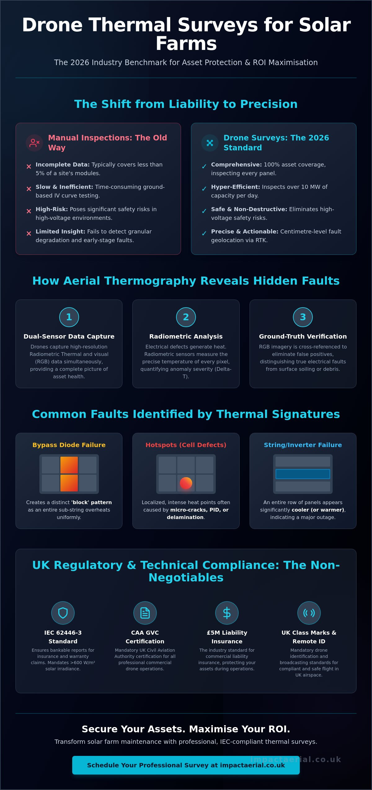
One of the most recognisable signatures is the ‘block’ heat pattern caused by bypass diode failures. When a diode fails, it can no longer bypass a shaded or defective part of the module, causing an entire sub-string to heat up uniformly. This creates a distinct rectangular thermal footprint that is easy to identify from the air. In contrast, ‘hotspots’ are usually localised and intense. These are often caused by micro-cracks in the silicon, delamination, or Potential Induced Degradation (PID). Even simple shadowing from overgrown vegetation or bird droppings can trigger these hotspots, which is why dual-sensor verification is vital to prevent unnecessary maintenance calls.

At a larger scale, thermal patterns reveal string-level outages or inverter failures. If an entire row of panels appears significantly cooler or warmer than its neighbours, it typically suggests an open circuit, a blown fuse, or a disconnected string. We categorise these anomalies using ‘Delta-T’, which is the temperature difference between the fault and a healthy reference point. A Delta-T of 10°C might indicate a minor performance issue, while a difference exceeding 30°C often signals a critical failure that poses a fire risk or significant revenue loss.

Common Fault Signatures in Solar Arrays

Defects typically fall into three categories: cell-level, string-level, and module-level. Cell-level defects like cracks or manufacturing flaws appear as small, intense points of heat. String-level issues are often systemic, appearing as entire lines of underperforming modules due to wiring faults or connector failures. Identifying whether a panel is completely ‘dead’ or merely underperforming is crucial for successful warranty claims. If you’re managing a large portfolio, our PV solar farm thermal surveys provide the granular data needed to justify these claims with manufacturers.

AI-Powered Data Analysis

The sheer volume of data from a utility-scale site is immense. We use AI-powered software to scan thousands of high-resolution images automatically. Machine learning algorithms are trained to recognise the specific signatures of bypass diodes, hotspots, and string outages with incredible accuracy. This automation reduces human error and significantly speeds up the reporting process. The final output is a digital ‘fault map’ with centimetre-level GPS coordinates, allowing your ground teams to walk directly to a problematic module rather than searching manually across acres of land.

Drone Thermal Survey for Solar Farms: The 2026 Guide to PV Inspection

Operational Benefits: ROI and Safety for Asset Managers

Transitioning to a drone thermal survey for solar farms moves your O&M strategy from reactive repair to proactive asset protection. The most immediate impact is the sheer speed of data collection. A professional drone team can survey over 10MW of capacity in a single day; a task that would take ground-based technicians weeks to complete using traditional IV-curve testing. This efficiency doesn’t just save on labour costs. It ensures that your site remains fully operational with minimal downtime during the inspection process.

Safety remains a non-negotiable priority for UK asset managers. Manual inspections require technicians to navigate uneven terrain while carrying handheld cameras in high-voltage environments. By moving the primary inspection tool into the air, you eliminate these ground-based risks. Drones capture high-resolution data from a safe distance, allowing your engineers to review findings from the safety of an office before any physical intervention is required. This methodical approach to risk mitigation is a hallmark of a mature, safety-conscious operation.

The financial justification for aerial thermography is found in revenue recovery. Research indicates that an undetected 5% yield loss on a 10MW solar farm can cost approximately £32,000 in lost revenue annually. A drone thermal survey for solar farms identifies these invisible losses by quantifying the kWh impact of every detected fault. Beyond immediate revenue, preventative maintenance catches minor hotspots before they escalate into catastrophic fire risks or total string failures, protecting the long-term integrity of your infrastructure.

Manual vs. Drone Inspections: A Comparison

Traditional manual audits are often limited to a 5% or 10% sample size due to time and budget constraints. This leaves 90% of your asset unmonitored. Drone deployment provides 100% asset inspection, ensuring no defective module is overlooked. This comprehensive data set improves site-wide health scores, which is vital for maintaining high portfolio valuations during acquisitions or refinancing. It’s the difference between guessing your site’s performance and having a verified digital record of every panel.

Warranty and Insurance Support

Securing successful warranty claims against manufacturers requires indisputable evidence. We provide timestamped, geolocated radiometric data that proves the exact nature and location of a defect. This level of ‘due diligence’ is also highly valued by insurance providers, often leading to more favourable premiums. For new sites, using a drone survey during the handover from EPC to O&M creates a ‘digital twin’ that establishes a performance baseline, ensuring you don’t inherit existing faults from the construction phase.

Regulatory Compliance: UK Drone Laws in 2026

Operating a drone thermal survey for solar farms within the United Kingdom requires more than just high-end hardware; it demands strict adherence to Civil Aviation Authority (CAA) regulations. As of 2026, the legal framework has become more stringent regarding Remote ID and operator accountability. For any commercial activity on energy infrastructure, the use of CAA GVC certified pilots is the only way to ensure your site remains compliant and fully insured. Using uncertified or hobbyist operators doesn’t just risk a fine; it can invalidate your site’s broader public liability insurance.

Professional solar surveys often take place near public rights of way or sensitive national infrastructure. This necessitates £5 million in commercial liability insurance as an absolute minimum industry standard. This level of coverage protects asset managers against the unlikely event of equipment failure or accidental damage to high-value PV strings. Data protection and GDPR compliance are also vital. Every piece of aerial imagery must be handled according to strict privacy regulations, ensuring that any incidental capture of persons or private property is managed through robust data redaction and secure storage protocols.

The Importance of GVC Certification

A standard hobbyist drone license is insufficient for the complexities of a utility-scale solar farm. The General Visual Line of Sight Certificate (GVC) is the professional benchmark, allowing for an Operational Authorisation from the CAA. This authorisation is essential when flying in congested environments or where specific distance separations from uninvolved persons must be maintained. It ensures every drone survey meets the latest 2026 safety protocols, including the mandatory use of UK class-marked aircraft and active Remote ID broadcasting.

Risk Mitigation on Solar Farms

Solar farms present unique operational challenges, specifically Electromagnetic Interference (EMI) from high-voltage inverters and substations. Our pre-flight planning involves detailed EMI assessments and weather monitoring to prevent fly-aways or data corruption. We work closely with site managers to ensure our flight paths cause zero disruption to ongoing ground maintenance. This meticulous approach includes maintaining a clear audit trail of flight logs and safety briefings, providing you with total transparency. If you need to ensure your next inspection is fully compliant, contact our team at Impact Aerial to discuss your specific site requirements.

Impact Aerial: Professional Solar Thermal Intelligence

At Impact Aerial, we don’t just provide imagery; we deliver actionable asset intelligence that protects your bottom line. Our drone thermal survey for solar farms utilises the industry-leading DJI Matrice 350 RTK equipped with the Zenmuse H20T sensor. This hardware configuration provides centimetre-level geolocating accuracy, which is essential for large-scale utility sites where traditional GPS might lead technicians to the wrong row. Based in Birmingham, we provide UK-wide coverage with a specific focus on the West Midlands, ensuring that regional asset managers have access to local, high-tier technical expertise. Our bespoke drone services are designed to integrate directly into your existing O&M software, providing a seamless transition from aerial data to ground-based repair.

The true value of our service lies in the post-production phase. We transform thousands of raw thermal images into GIS-ready orthomosaics and digital twins of your entire site. This allows you to view your solar farm as a single, high-resolution map where every fault is clearly marked and categorised. By processing data with such precision, we ensure that your maintenance teams spend less time searching for problems and more time fixing them. This methodical approach is why we are trusted by some of the UK’s leading renewable energy investors to monitor their most critical infrastructure.

Our Technical Capability

We specialise in the capture and analysis of full radiometric thermal data. Unlike standard thermal video, radiometric files allow us to re-analyse every pixel post-flight to extract specific temperature values. This is vital for calculating Delta-T accurately and determining the urgency of a repair. Our expertise in aerial filming drone technology also allows us to produce cinematic-quality site visualisations that are perfect for stakeholder presentations and investor updates. We deliver data in multiple formats to suit your needs, including GeoTIFF for GIS software, RJPEG for detailed fault inspection, and interactive cloud-based maps for mobile access in the field.

The Impact Aerial Difference

Our operation is built on a foundation of meticulous safety and regulatory compliance. We don’t just fly drones; we manage high-stakes data operations in complex environments. This dedication to quality ensures that every report we produce is ‘bankable’. Whether you are preparing for a site acquisition, filing a warranty claim, or conducting an annual health check, our data provides the technical weight required by insurers and financial institutions. We act as your technical consultants, providing the reassurance and reliability you need to manage a high-performing solar portfolio. Please contact Impact Aerial for a detailed quote on your next solar farm survey.

Securing the Future of Your Solar Infrastructure

The transition from manual audits to automated aerial intelligence is no longer optional for utility-scale sites aiming for peak efficiency. By adopting a professional drone thermal survey for solar farms, you move beyond sample-based guessing to 100% asset transparency. You’ve seen how radiometric data identifies bypass diode failures and string outages with surgical precision; this allows your O&M teams to act before minor faults become critical liabilities.

Adhering to the latest 2026 UK regulations is vital for protecting your investment. Impact Aerial provides the technical expertise needed to navigate these high-stakes operations safely. Our team utilizes DJI Enterprise grade radiometric sensors and operates with CAA GVC certified pilots, backed by £5m commercial liability insurance for your peace of mind. We transform raw thermal signatures into bankable asset intelligence that secures your ROI for years to come.

Don’t leave your site’s performance to chance. Request a quote for your solar farm thermal survey from Impact Aerial today and take the first step toward total site optimisation. We’re ready to help you maximise your energy yield with precision and reliability.

Frequently Asked Questions

What is the best time of day for a solar thermal drone survey?

The best time for a survey is between 10:00 and 14:00 when the sun is at its highest point. This ensures that solar irradiance exceeds the 600 W/m² threshold required by international IEC 62446-3 standards. Panels must be fully active and under load to reveal the thermal anomalies that indicate underlying electrical faults.

Can drones detect micro-cracks in solar panels?

Drones detect the thermal signatures created by micro-cracks rather than the physical cracks themselves. These cracks create localized electrical resistance, which shows up as distinct hotspots on a radiometric thermal map. Identifying these issues early prevents them from developing into more serious problems like delamination or total module failure.

How much does a drone thermal survey for a solar farm cost?

The investment for a drone thermal survey for solar farms depends on the total megawatt (MW) capacity and the specific reporting requirements of the asset manager. Factors such as site location, terrain complexity, and the need for centimetre-level RTK accuracy will influence the final project cost. We recommend requesting a bespoke quote to ensure all technical and safety requirements are covered.

Do I need to turn off the solar farm during the drone survey?

You must keep the solar farm fully operational and connected to the grid during the inspection. Thermal sensors rely on the heat generated by the flow of electricity to identify defective components. If the system is powered down, the faulty cells won’t exhibit the temperature differences (Delta-T) necessary for a successful diagnosis.

What is the accuracy of a drone thermal sensor for PV modules?

Professional radiometric sensors provide incredible precision, often detecting temperature variations as small as 0.05°C. When these sensors are integrated with RTK positioning hardware, we can geolocate faults with centimetre-level accuracy. This level of detail allows your O&M teams to navigate directly to a defective module without wasting time searching across the site.

How long does it take to receive the final thermal inspection report?

Final reports are typically delivered within 5 to 10 working days after the flight operation is completed. This window allows for the processing of thousands of high-resolution images through AI-powered analysis platforms followed by a manual review by certified thermographers. For multi-site portfolios, we provide a structured delivery schedule to manage data flow efficiently.

What weather conditions are required for an IEC-compliant thermal survey?

Compliance requires clear skies, no precipitation, and wind speeds typically below 15mph to maintain aircraft stability. The most critical requirement is a stable solar irradiance of at least 600 W/m². Intermittent cloud cover can cause fluctuating panel temperatures, which leads to unreliable data and potential false positives in the final report.

Is a drone survey suitable for rooftop solar or only large-scale farms?

Drone technology is equally effective for commercial rooftop installations and utility-scale ground-mount sites. For rooftops, a drone thermal survey for solar farms or commercial buildings is often safer and more cost-effective as it removes the need for scaffolding or risky roof walks. The high-resolution radiometric data remains the same regardless of the installation’s height or mounting structure.

Thermal Drone Survey for Solar Farms: A Complete Guide

Is your solar farm’s energy output consistently falling short of projections, leaving you searching for an invisible fault? When traditional manual inspections prove too slow, costly, and hazardous, a professional thermal drone survey for solar farms provides the definitive solution. These hidden inefficiencies don’t just erode your revenue; they can escalate into major system failures or fire risks if left undetected, making a proactive approach essential for asset protection and operational peace of mind.

This complete guide is designed for solar farm operators seeking to move beyond reactive, expensive maintenance. We will explore exactly how this advanced inspection method uses high-resolution aerial thermography to pinpoint specific faults-from defective cells and bypass diodes to inverter malfunctions-with unparalleled speed and accuracy. Discover how to interpret this critical, actionable data to guide your maintenance teams, significantly boost your farm’s energy output, enhance site safety, and ultimately maximise your return on investment.

Key Takeaways

  • Discover why traditional manual inspections are inefficient and how aerial surveys provide a faster, more comprehensive method for fault detection.
  • Learn how thermal data pinpoints specific anomalies-from faulty cells to inverter issues-before they escalate into significant energy and revenue loss.
  • A professional thermal drone survey for solar farms delivers a clear return on investment by reducing operational downtime and maximising your asset’s energy output.
  • Understand the non-negotiable criteria for selecting a qualified UK drone survey partner, including essential CAA certifications and commercial liability insurance.

Why Manual Solar Farm Inspections Are No Longer Viable

In the management of large-scale solar assets, maximising operational efficiency and return on investment is paramount. For years, the standard approach involved teams of technicians manually walking sites, using handheld thermal cameras to spot-check panels for defects. While once considered adequate, this methodology is now fundamentally outdated and inefficient for the scale of modern solar farms. The sheer size of these installations means ground-based inspections are incredibly slow, expensive, and present significant safety challenges.

Contrast this with the comprehensive data-gathering capabilities of modern aerial solutions. A professional thermal drone survey for solar farms can capture high-resolution data on every single panel across a vast site in a fraction of the time, providing a complete health overview rather than a fragmented sample. This shift in approach is not just an improvement; it is a necessary evolution for effective asset management.

The Inefficiency of Manual Spot-Checks

A ground team can only physically inspect a small fraction of a solar farm’s total panels in a given day. This spot-checking process is not only time-consuming, often taking weeks for larger sites, but it also leaves significant gaps in your data. Faults such as hotspots, delamination, or defective cells can easily develop and worsen between these infrequent manual checks, leading to progressive energy loss. Furthermore, drones equipped with advanced thermal imaging technology capture consistent, georeferenced data that allows for precise year-on-year comparisons, a level of accuracy manual reporting simply cannot match.

High Costs and Labour Intensity

The operational expenditure associated with manual inspections can be substantial. Deploying a team of skilled technicians for days or weeks incurs significant labour costs, accommodation, and travel expenses. There is also the inherent risk of accidental damage to panels or cabling caused by foot traffic across the site. Every hour spent on manual inspections is an hour that could be dedicated to essential repairs, and any associated downtime directly translates into lost production and reduced revenue.

Critical Safety and Liability Risks

The safety of on-site personnel is a primary concern for any responsible operator. Manual inspections expose technicians to a range of hazards, including:

  • Direct contact with high-voltage equipment.
  • Slips, trips, and falls on challenging or uneven terrain.
  • Physical strain and heat exhaustion from working in exposed conditions.

A thermal drone survey for solar farms removes these risks entirely by keeping personnel out of harm’s way. This remote approach not only protects your team but also reduces liability, providing asset managers with invaluable peace of mind.

The Thermal Drone Survey Process: From Planning to Data Capture

A high-quality thermal drone survey is far more than just a flight; it is a meticulously executed technical operation. To provide asset managers with actionable data that directly impacts ROI, we follow a rigorous, three-stage process. This methodical approach guarantees safety, full compliance with UK regulations, and the highest standard of data integrity from start to finish.

Step 1: Pre-Flight Planning and Risk Assessment

Every successful operation begins with detailed planning. We collaborate closely with your asset management team to confirm survey objectives and define the exact site boundaries. Our process includes comprehensive airspace checks to ensure no conflicts with controlled airspace or local restrictions. Crucially, we develop a site-specific operational safety case and risk assessment, identifying all potential hazards and outlining clear mitigation strategies. This isn’t just a box-ticking exercise; it’s a core part of our commitment to safety and provides you with complete peace of mind before our team even arrives on site.

Step 2: On-Site Data Acquisition

On the day of the survey, our CAA GVC certified pilots execute the pre-planned flight mission with precision. We utilise commercial-grade drones equipped with high-resolution radiometric thermal sensors and RGB cameras. Flying automated grid patterns ensures 100% systematic coverage of every panel on your solar farm. A key advantage of our approach to a thermal drone survey for solar farms is the simultaneous capture of both thermal and visual data. This dual-data method is essential for accurate fault diagnosis, allowing our analysis team to cross-reference thermal anomalies with visual evidence of soiling, physical damage, or shading.

Step 3: Optimal Conditions for Thermal Data

The quality of thermal data is entirely dependent on environmental conditions. To detect faults accurately, solar panels must be under sufficient load, which requires clear skies and high solar irradiance. We only conduct surveys when irradiance levels are above a minimum threshold of 600 W/m², ensuring that temperature differences between healthy and faulty cells are distinct and measurable. Low wind speeds are also critical to avoid convective cooling of the panels, which can mask thermal signatures. By scheduling flights during optimal times of the day, we capture the clean, high-contrast imagery necessary for the complex methodologies involved in analyzing thermal data from drones to identify specific issues like hotspots or potential-induced degradation.

Decoding the Data: Actionable Insights from Your Survey

A thermal drone survey captures thousands of high-resolution radiometric images, but this raw data is only the first step. The true value lies in expert analysis, which transforms complex thermal information into a clear, actionable strategy for your operations and maintenance (O&M) teams. This process is crucial for identifying underperforming assets and safeguarding your return on investment.

Common Faults Identified by Thermal Imaging

Our advanced thermal sensors can detect minute temperature variations that are invisible to the naked eye, revealing a wide range of issues that degrade panel efficiency. Our analysis pinpoints and classifies these anomalies, which commonly include:

  • Cell-level faults: Such as hotspots, micro-cracks, and internal short-circuits that indicate localised failures within a panel.
  • Module-level issues: Including delamination, moisture ingress, and significant soiling or vegetation shading that impacts the entire module.
  • String and system faults: We identify malfunctioning bypass diodes, which can take entire sections of a string offline, and highlight potential inverter issues.
  • Potential Induced Degradation (PID): Early identification of PID patterns allows for corrective action before it leads to widespread, irreversible power loss.

From Raw Data to Actionable Reports

Our meticulous data-gathering and processing workflow ensures nothing is missed. We stitch together thousands of individual images to create a georeferenced thermal orthomosaic map, providing a complete thermal overview of your entire site. Each identified fault is pinpointed on this map with precise GPS coordinates. Critically, we classify every anomaly by severity-from minor issues to critical failures-allowing your O&M team to prioritise repairs efficiently, focusing on the faults that cause the most significant production losses. This structured approach is what makes a professional thermal drone survey for solar farms an indispensable maintenance tool.

The Final Deliverable Package

Upon completion of our analysis, you receive a comprehensive package designed for immediate action. This high-quality report provides your team with everything needed to execute targeted, cost-effective maintenance and boost your asset’s performance. The standard package includes:

  • High-resolution visual (RGB) and thermal orthomosaic maps of the solar farm.
  • A detailed list of all identified anomalies, complete with GPS coordinates, severity classification, and thermal imagery.
  • A prioritised action list to guide your O&M team’s remedial work.

This clear, data-driven reporting gives you complete oversight of your asset’s health. See an example of our survey reports.

The Business Case: Quantifying the ROI of Drone Inspections

Investing in a professional thermal drone survey for a solar farm is not an operational expense; it is a strategic investment in asset performance and profitability. The high-resolution data gathered during an aerial inspection translates directly into tangible financial returns by boosting energy output, slashing maintenance costs, and safeguarding the long-term value of your renewable energy asset. By moving beyond simple visual checks, you can quantify performance and make data-driven decisions that directly impact your bottom line.

Boosting Energy Production and Revenue

On a utility-scale solar farm, even minor, invisible faults like hotspots, soiling, or Potential Induced Degradation (PID) can cascade into significant production losses. A single underperforming panel may seem trivial, but across thousands of modules, this can equate to tens of thousands of pounds in lost revenue annually. Industry data indicates that identifying and rectifying these faults can lead to an energy recovery of 1-5%, restoring the asset to its optimal generation capacity and maximising your revenue stream.

Reducing Operational & Maintenance (O&M) Costs

Traditional manual inspection methods are time-consuming, labour-intensive, and prone to human error. A thermal drone survey is fundamentally more efficient, delivering comprehensive data up to 97% faster than ground-based teams. This efficiency provides direct cost savings by:

  • Minimising Labour Hours: Drastically reducing the time technicians spend on-site performing routine inspections.
  • Improving Diagnostic Accuracy: Pinpointing the exact location and nature of faults, allowing maintenance teams to arrive prepared and resolve issues faster.
  • Enabling Proactive Maintenance: Shifting from a costly reactive repair model to a predictive strategy that addresses minor issues before they cause catastrophic failures.

Enhancing Asset Value and Longevity

The detailed reports generated from a thermal drone survey for solar farms are invaluable for asset management. This documentation provides the indisputable, geolocated evidence required to process successful warranty claims with panel manufacturers, which can save you significant replacement costs. Furthermore, regular surveys create a historical performance log, allowing you to track degradation over time and make informed decisions about the asset’s future. For added peace of mind, this level of professional oversight is often a requirement to maintain compliance with insurance policies, protecting your investment against unforeseen events.

How to Choose a Professional Drone Survey Partner in the UK

Selecting the right partner for your solar farm inspection is as critical as the technology itself. The quality of the data, the safety of the operation, and the ultimate value you receive all depend on the provider’s professionalism and expertise. A substandard survey can lead to missed defects and non-compliance, undermining your investment. To ensure you receive accurate, actionable insights, your chosen partner must meet a stringent set of criteria.

Essential Compliance and Certification

In the UK, commercial drone operations are strictly regulated by the Civil Aviation Authority (CAA). Never engage a provider who cannot immediately supply proof of the following non-negotiables. This is your first and most important due diligence step.

  • Valid CAA General Visual Line of Sight Certificate (GVC): This is the current standard qualification required for commercial drone operations in the UK, proving the operator is competent and understands aviation safety regulations.
  • Specialist Commercial Drone Insurance: Standard liability insurance does not cover aviation. Verify they hold a policy specifically for commercial drone use with a minimum of £5 million in public liability coverage for your peace of mind.
  • Detailed Risk Assessment and Method Statement (RAMS): For any professional operation, the provider must supply a comprehensive RAMS document outlining how they will conduct the survey safely and mitigate all potential risks on your site.

The Right Technology and Expertise

Compliance is the baseline; true value comes from a deep understanding of thermography and solar asset management. Executing a successful thermal drone survey for solar farms requires more than just a drone; it demands specialist technology and analytical skill.

  • Professional Equipment: The drone must be equipped with a high-resolution radiometric thermal sensor. Radiometric data allows for precise temperature measurement of every pixel, which is essential for accurately identifying and classifying faults like hotspots or defective cells.
  • Certified Thermography Pilots: Your pilot should be more than just a flyer; they need to be a certified thermographer (e.g., ITC Level 1 or higher). This qualification ensures they understand thermal science, can configure the equipment correctly, and can accurately interpret the thermal data they capture.
  • Advanced Reporting Capabilities: Ask for sample reports. The final deliverable should be a clear, comprehensive report that pinpoints the exact location of anomalies, classifies their severity, and provides actionable recommendations for your O&M team.

Why Choose Impact Aerial?

At Impact Aerial, we are built on a foundation of regulatory compliance, technical expertise, and a commitment to delivering tangible value. We meet and exceed all the critical criteria for a leading thermal drone survey for solar farms provider.

  • We are fully CAA GVC certified and hold comprehensive commercial insurance, ensuring every operation is safe and compliant.
  • Our expert pilots are also trained thermographers, combining elite aviation skills with a deep understanding of thermal data analysis.
  • We utilise leading radiometric thermal sensors and sophisticated software to generate detailed, actionable reports that empower you to protect your assets and maximise your ROI.

Don’t leave your solar investment to chance. Contact our expert team for a detailed consultation.

Secure Your Solar Investment with Professional Thermal Surveys

As we’ve explored, the era of manual solar farm inspections is over. The shift towards advanced aerial thermography is a strategic necessity for maximising efficiency and protecting your capital investment. A professional thermal drone survey for solar farms delivers unparalleled speed, safety, and data accuracy, transforming routine maintenance into a powerful asset optimisation tool. By identifying hidden defects like cell failures and PID before they escalate, you can secure your revenue streams and extend the operational life of your assets.

Choosing the right partner is crucial. At Impact Aerial, our team consists of fully CAA GVC Certified pilots, backed by £5m in commercial liability insurance for your complete peace of mind. As experts in aerial thermography and data analysis, we are committed to turning complex data into clear, actionable reports. Take the next step in optimising your solar farm’s performance and safeguarding its future profitability.

Request a Quote for Your Solar Farm Thermal Survey today and discover the Impact Aerial difference.

Frequently Asked Questions

How often should a solar farm have a thermal drone survey?

For optimal performance and preventative maintenance, we recommend a comprehensive thermal drone survey for solar farms on an annual basis. This establishes a regular health check to identify developing faults. Additionally, a survey is crucial immediately after commissioning to create a baseline performance report and following any significant weather events, such as severe hailstorms or high winds, to quickly assess for any potential damage and support insurance claims.

What is the ideal time of year and weather for a solar farm inspection?

The key to an effective thermal inspection is high solar irradiance, ideally above 600 W/m², to ensure thermal anomalies are clearly visible. This means inspections are best conducted on clear, sunny days with minimal cloud cover and low wind speeds (under 15 mph). While late spring and summer in the UK typically offer these conditions, our CAA GVC certified pilots can operate year-round, scheduling surveys for days when the specific meteorological requirements are met.

How much does a thermal drone survey for a solar farm cost?

The cost of a thermal drone survey is dependent on the size (MW) and complexity of the solar farm, as well as the required detail level of the final report. As a guide, prices typically range from £150 to £300 per MW. Smaller sites may have a minimum project fee. For an accurate, detailed quotation tailored to your specific asset and reporting needs, we recommend contacting our team for a professional consultation.

Can drones detect issues other than heat anomalies, like soiling or damage?

Absolutely. Our survey drones are equipped with dual payloads, carrying both a high-resolution radiometric thermal camera and a high-definition visual (RGB) camera. This allows our teams to conduct a thorough inspection that identifies not only thermal faults like defective cells or bypass diodes, but also physical issues. These include panel soiling, cracking, delamination, vegetation encroachment, and potential damage to mounting structures, providing a complete overview of your asset’s condition.

What specific drone and camera technology do you use for solar inspections?

We utilise leading commercial-grade equipment to ensure top-quality data gathering and analysis. Our fleet includes advanced enterprise-grade drones, renowned for their stability, extended flight endurance, and precision. These are paired with high-resolution radiometric thermal sensors, which allow for precise temperature measurement on a per-pixel basis. This professional services combination ensures we capture the meticulous, actionable data you require.

How long does it take to survey a 50MW solar farm and receive the final report?

Efficiency is key to our professional services. The on-site data capture for a 50MW solar farm can typically be completed by our certified pilots within one to two full days, subject to weather conditions. Following the survey, our data analysts meticulously process the thermal and visual imagery. You can expect to receive a comprehensive, detailed report outlining all findings, fault classifications, and recommended actions within 5-7 working days of the survey’s completion.