
Benefits of Thermal Imaging for Roofs: A Guide to Aerial Infrared Surveys

Why would you spend thousands on scaffolding and manual inspections when the most critical structural threats remain invisible to the naked eye? It’s a common frustration for site managers and property owners who face recurring leaks that traditional surveys simply cannot locate. You shouldn’t have to risk a roofer’s safety or blow through your maintenance budget on guesswork and invasive testing.

We understand that maintaining a large-scale facility requires technical precision and a commitment to safety. This guide explores the significant benefits of thermal imaging for roofs, showing you how aerial infrared surveys pinpoint hidden moisture, insulation failures, and structural risks with surgical accuracy. By utilizing high-resolution radiometric sensors and adhering to ASTM C1153 standards, you can justify repair budgets with hard visual data while keeping your team safely on the ground. We’ll preview how CAA-certified drone operations are transforming asset management, from identifying hot spots after sunset to meeting the latest 2026 UK Remote ID regulations. Discover how to turn an invisible problem into a clear, actionable maintenance plan.

Key Takeaways

  • Understand how infrared sensors detect subsurface moisture by identifying the unique heat signatures retained by wet insulation.
  • Explore the primary benefits of thermal imaging for roofs, including the elimination of costly scaffolding and the ability to survey vast commercial areas rapidly.
  • Learn why the timing of a survey is critical, specifically how solar loading and twilight conditions ensure the most accurate data capture.
  • Identify hidden structural risks such as moisture entrapment and insulation gaps before they develop into expensive internal damage.
  • Recognize the necessity of CAA GVC certified pilots and comprehensive commercial liability insurance to ensure a compliant and safe site survey.

What is Thermal Imaging for Roofs and How Does it Work?

Thermal imaging for roofs is a non-destructive testing method that utilizes specialized infrared cameras to capture the heat signatures emitted by a building’s structure. Unlike standard photography, which relies on visible light, thermography detects radiation in the long-wave infrared spectrum. One of the standout benefits of thermal imaging for roofs is its ability to identify anomalies that are completely invisible to the human eye. By measuring these temperature variations, surveyors can create a detailed map of a roof’s thermal performance.

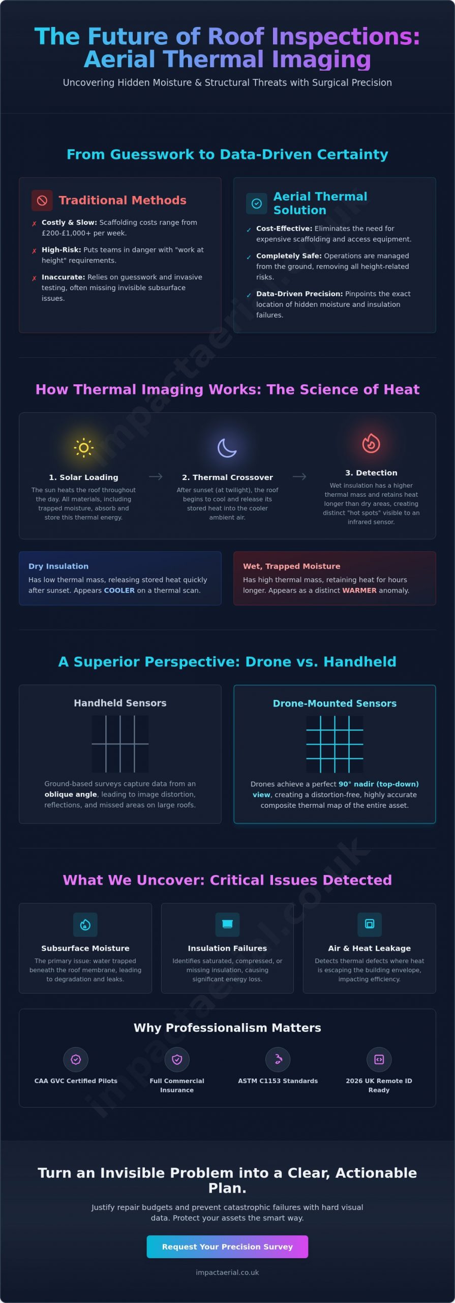
To understand the fundamentals of What is Thermography, one must recognize that every material absorbs and emits heat at different rates. When a roof is exposed to sunlight, it stores energy. As the environment cools at night, the roof begins to release that energy. Areas containing trapped moisture will appear warmer on a thermal scan because water has a higher thermal mass than dry insulation. This allows our sensors to “see” the thermal footprint of a leak through the surface-level membrane without ever cutting into the material.

To see a practical application of this technology on a commercial site, watch this thermal inspection in action:

The Science of Thermography

Thermodynamics is the core of this process. Thermal cameras don’t actually see through membranes; instead, they detect the heat energy being conducted from the materials underneath. In the context of moisture entrapment, thermal mass is the ability of wet insulation to store and retain heat energy significantly longer than the surrounding dry components. This temperature differential allows the camera to produce a thermogram, which is a visual representation where different colors correspond to specific temperature values. This data-centric approach removes the guesswork from traditional roof inspections.

Handheld vs. Drone-Mounted Thermal Sensors

Ground-based inspections using handheld cameras often struggle with perspective. On a large commercial flat roof, a surveyor on foot can only capture data from an oblique angle, which leads to image distortion and missed patches. DJI Enterprise drone sensors provide a significant upgrade in data quality. By flying at height, drones achieve a 90-degree nadir view. This top-down perspective is essential for creating an accurate, distortion-free moisture map of the entire site. This level of precision is one of the major benefits of thermal imaging for roofs, as it provides a comprehensive composite map that ground-based surveys simply cannot match.

The Primary Benefits of Aerial Thermal Roof Surveys

Transitioning from the science of thermography to practical application reveals why this technology is now a cornerstone of modern facility management. One of the most immediate benefits of thermal imaging for roofs is the sheer speed of data acquisition. A drone can survey a 50,000-square-foot industrial roof in a fraction of the time it takes a manual team to walk the site with handheld sensors. This rapid turnaround isn’t just about efficiency; it’s about capturing a snapshot of the entire roof under consistent environmental conditions, ensuring that temperature differentials aren’t skewed by changing weather during the survey.

Cost reduction is equally significant. Traditional inspections often require expensive scaffolding or cherry pickers just to gain access to high-level structures. Research indicates that scaffolding costs in the UK typically range from £200 to £1,000 per week, an expense that aerial surveys completely bypass. By choosing an aerial approach, you’re investing in data rather than temporary hardware. This method constitutes a high-tier form of non-destructive testing, allowing us to detect thermal defects such as air leakage or wet insulation without compromising the integrity of the roof’s protective membrane.

Enhanced Safety and Risk Mitigation

Safety remains the primary driver for many commercial operators. By keeping surveyors on the ground, we eliminate the inherent “work at height” risks that complicate standard inspections. Our operations align strictly with modern HSE guidelines, significantly reducing the liability for property managers. When you remove the need for personnel to navigate fragile roof surfaces or steep pitches, you create a safer work environment and simplify the logistics of your routine maintenance schedule. It’s a proactive way to manage risk while maintaining full compliance with safety protocols.

Precision and Visual Documentation

The output of an aerial survey provides more than just a list of problems; it delivers undeniable visual proof. This radiometric data is invaluable when filing insurance claims or preparing repair tenders, as it offers a clear “heat map” of the damage. Establishing this baseline of roof health allows you to track deterioration over time with meticulous detail. For those managing multiple assets, integrating these findings into broader drone property surveys ensures that every structural component is accounted for. If you’re ready to secure your building’s future, our drone commercial property surveys provide the expert oversight needed to justify your maintenance budget and protect your investment.
Benefits of Thermal Imaging for Roofs: A Guide to Aerial Infrared Surveys

Specific Issues Detected by Thermal Imaging

While the overarching benefits of thermal imaging for roofs include safety and cost-efficiency, the true value lies in the granular data it provides regarding structural failures. We don’t just look for water dripping through a ceiling. Instead, we identify the precise moment a roof’s integrity begins to fail, often years before a visible leak appears. This proactive approach allows for targeted repairs that extend the life of the entire asset. By utilizing high-resolution radiometric sensors, we can detect anomalies that traditional visual surveys consistently overlook.

Moisture Mapping and Leak Detection

In the UK, the best results occur after sunset when the roof surface cools. Wet insulation appears as distinct “hot spots” because it retains solar energy longer than dry material. This phenomenon allows us to map moisture entrapment with surgical precision. By adhering to professional standards for roof thermography, we can pinpoint the exact entry point of a leak rather than just observing where the water eventually pools inside the building. Flat roofing systems are the ideal candidates for thermal moisture scans because their uniform surface allows for a clear, unobstructed view of the thermal patterns created by subsurface anomalies. This detailed mapping prevents the common mistake of replacing an entire roof when only a specific section is compromised.

Energy Efficiency and Heat Loss

Thermal imaging is a powerful tool for businesses striving to meet ambitious ESG (Environmental, Social, and Governance) goals. By identifying “cold spots” on the roof surface during winter months, we can locate failed insulation boards that allow internal heat to escape. These insulation gaps represent a massive waste of HVAC energy and increase the building’s carbon footprint. We also look for thermal bypasses at roof-to-wall junctions, where air leakage often goes undetected. Addressing these thermal bridges ensures the building envelope remains airtight and energy-efficient. This data is essential for justifying energy-saving upgrades and proving the return on investment for insulation repairs.

Structural Anomalies and Drainage Monitoring

Beyond moisture and heat, infrared sensors reveal structural anomalies that might otherwise remain hidden. Thermal bridges, where highly conductive materials like steel beams penetrate the insulation layer, show up clearly on our scans. These areas are prone to condensation and eventual rot if left unmanaged. Additionally, we use thermal data to monitor the health of flat roof drainage systems. Pooling water has a different thermal signature than the rest of the roof, allowing us to identify blocked drains or subtle depressions in the roof deck that threaten structural stability. Integrating this data into your long-term asset management strategy ensures that minor maintenance issues don’t escalate into catastrophic failures.

Optimising Results: Timing and Conditions in the UK

Achieving high-quality radiometric data requires more than just high-end hardware. It demands a meticulous understanding of the UK’s environmental variables. The primary benefits of thermal imaging for roofs are only fully realized when the survey is conducted during the optimal “thermal window.” This window is dictated by the diurnal cycle, a 24-hour temperature swing that allows us to differentiate between dry and saturated materials. Without the correct environmental timing, even the most advanced sensors will fail to produce actionable data.

The process begins with “solar loading,” where the sun’s energy heats the roof structure throughout the day. To ensure accuracy, we strictly follow ASTM C1153 standards, which require specific conditions such as a dry roof surface for at least 24 hours and wind speeds typically below 15 mph. High winds can strip heat from the roof surface through convective cooling, which masks the subtle temperature differences we need to detect. We prioritize clear, cold nights following a day of significant solar loading to maximize the contrast between wet and dry insulation.

The Diurnal Cycle Explained

The most effective thermal scans happen at twilight or during early nightfall. After the sun sets, dry roofing materials cool down rapidly because they have low thermal mass. In contrast, wet insulation or trapped moisture retains that heat for much longer. If we launch a drone too early, the residual heat from the surface membrane can mask the underlying defects, a phenomenon known as the wash-out effect. By waiting for the peak temperature differential, usually two to four hours after sunset, we can pinpoint moisture entrapment with surgical precision. Managing the UK’s unpredictable rain patterns is the greatest challenge, as a wet surface will evaporate and cool the roof, creating false “cold spots” that invalidate the survey results.

Material Compatibility

Not all roofing materials react to infrared radiation in the same way. EPDM (rubber) and bituminous membranes are ideal for thermography because they have high emissivity, meaning they are very efficient at emitting thermal energy. Highly reflective “cool roofs” or new metal standing seams present a greater challenge because they act like mirrors, reflecting the cold temperature of the sky rather than emitting their own heat. Our pilots meticulously adjust emissivity settings and camera angles to compensate for these reflective surfaces. To ensure your asset is surveyed under these precise conditions, you can book our drone commercial property surveys to secure a data-rich report that accurately reflects your roof’s health.

Why Professional Drone Surveys are the Industry Standard

Professionalism in aerial thermography isn’t just about owning a drone; it’s about the technical rigour and regulatory compliance behind every flight. While the benefits of thermal imaging for roofs are clear, the quality of the data depends entirely on the operator’s expertise and the hardware used. We leverage DJI Enterprise systems, such as the Matrice 350 or 400 series equipped with high-resolution radiometric sensors, to capture precise temperature data. This technology allows us to measure the exact heat signature of any point on the roof surface, providing a level of detail that standard visual inspections can’t match. This data-centric approach ensures that stakeholders receive a definitive, evidence-based assessment of their property’s condition.

Compliance and Safety Standards

Operating a drone for commercial purposes in the UK requires strict adherence to aviation law. As of January 2026, regulations have become more stringent, requiring Remote ID for drones with cameras and lowering registration thresholds. We operate with full CAA General Visual Line of Sight Certificate (GVC) qualifications, which are essential for conducting surveys in complex urban or industrial environments. Understanding the specific requirements for a drone license is vital for site managers who must ensure their contractors are fully legal and current with 2026 standards. Beyond licensing, we provide detailed Risk Assessments and Method Statements (RAMS) and maintain £5m in commercial liability insurance. This meticulousness guarantees that your site survey is conducted with the highest safety standards in mind, providing the psychological comfort that your asset is in expert hands.

From Data to Decision Making

The true value of a survey lies in the transition from raw data to actionable intelligence. It’s easy to capture a thermal image, but it’s much harder to produce a report that a structural engineer or insurance provider can rely on. Our drone survey reports are designed to direct repair teams exactly where they are needed, eliminating the need for broad-spectrum “exploratory” repairs. We use advanced post-production software to analyze thermal anomalies, filtering out false positives like HVAC exhaust or solar reflections. This ensures that the benefits of thermal imaging for roofs translate into tangible cost savings and efficient maintenance schedules. By providing a clear visual baseline of roof health, we help property managers justify their repair budgets with hard evidence. If you’re ready to move away from guesswork and embrace data-driven asset management, contact Impact Aerial for a professional thermal roof survey quote and let our experts secure your building’s future.

Securing Your Building’s Future with Thermal Data

Aerial thermography has redefined how we protect large-scale commercial assets. By identifying subsurface moisture and insulation gaps long before they manifest as internal damage, you’re not just fixing leaks; you’re preserving the structural integrity of your property. The benefits of thermal imaging for roofs extend far beyond simple detection. They provide the hard evidence needed to justify maintenance budgets and ensure your site remains compliant with modern safety standards. This data-driven approach removes the high costs of scaffolding and the risks of manual inspections.

We combine high-end DJI Enterprise radiometric sensors with the expertise of CAA GVC certified pilots to deliver reports that are both technically precise and legally compliant. With £5m in commercial liability insurance, we provide the security and reliability that complex industrial sites demand. Don’t leave your roof’s health to guesswork or invasive testing that risks damaging your facility membrane. It’s time to gain total visibility over your assets with professional aerial oversight.

Request a Professional Thermal Roof Survey from Impact Aerial today to secure a comprehensive assessment of your building’s health. We’re ready to help you turn invisible risks into a clear, actionable plan for long-term success.

Frequently Asked Questions

Is thermal imaging for roofs accurate in finding all leaks?

Thermal imaging is exceptionally accurate at identifying moisture entrapment and thermal anomalies that standard visual inspections miss. However, it is a diagnostic tool that identifies temperature differentials rather than a definitive leak seeker in every scenario. To ensure 100% certainty, we recommend verifying thermal findings through non-destructive moisture meter testing or core sampling as per industry standards. This combined approach maximizes the benefits of thermal imaging for roofs by providing a verified roadmap for repairs.

Can you perform a thermal roof survey during the day?

Daytime surveys are generally ineffective because direct solar radiation creates thermal noise that masks subsurface temperature differences. For accurate results, we conduct surveys at twilight or during the night when the roof surface has cooled sufficiently. This specific timing allows the heat retained by wet insulation to become visible against the rapidly cooling dry sections. Scheduling during these hours is critical for capturing the high-contrast radiometric data required for a professional structural assessment.

What roof materials work best with infrared cameras?

Low-reflectivity materials with high emissivity, such as EPDM rubber, bituminous membranes, and modified bitumen, provide the most reliable results. These surfaces efficiently emit thermal energy, allowing our sensors to capture clear heat signatures. In contrast, highly reflective surfaces like new metal or cool roofs can act as mirrors, reflecting sky temperatures instead of emitting their own heat. Our pilots adjust camera settings and flight paths to mitigate these reflections, ensuring data accuracy across diverse commercial roofing systems.

How much does a drone thermal roof survey cost in the UK?

The cost of a drone thermal roof survey varies based on the total surface area, the complexity of the roof structure, and the specific reporting requirements. Factors such as the building’s location and the need for specialized flight permissions in restricted airspace also influence the final investment. We provide bespoke quotes that reflect the meticulous planning and high-end hardware required for a compliant, data-rich survey. Contacting us directly ensures you receive a quote tailored to your facility’s specific maintenance needs.

Do I need to shut down my building during the drone survey?

There is no need to shut down your building or interrupt daily operations during an aerial survey. Our drones operate at a safe altitude and remain entirely non-intrusive, allowing your staff and tenants to continue their work without distraction. Because we typically conduct thermal scans after sunset to optimize data quality, the impact on site activity is virtually non-existent. This operational flexibility is a key advantage for busy commercial and industrial facilities that cannot afford downtime.

What is the difference between a visual drone survey and a thermal one?

A visual drone survey uses high-resolution RGB cameras to identify surface-level defects like cracked tiles, blocked gutters, or loose flashings. A thermal survey utilizes radiometric infrared sensors to detect subsurface issues like moisture entrapment and insulation failure. While visual surveys show you what is broken on the exterior, thermal imaging reveals the hidden structural risks beneath the membrane. Combining both methods provides a comprehensive overview of your roof’s total health and energy performance.

Can thermal imaging see through standing water on a roof?

Thermal imaging cannot see through standing water or heavy ponding on a roof surface. Water on the surface acts as a thermal barrier, equalizing the temperature and masking the heat signatures of the materials underneath. For a successful survey, the roof must be completely dry for at least 24 hours prior to the flight. This ensures that the temperature differentials we detect are caused by internal moisture entrapment rather than surface-level evaporation or pooling water.

How long does it take to receive the thermal survey report?

You can typically expect to receive your comprehensive survey report within three to five working days following the flight. While the data capture itself is rapid, the post-production phase requires meticulous analysis by our technical team to identify and verify thermal anomalies. We convert raw radiometric data into actionable insights, providing you with a detailed map of leak locations and insulation gaps. This thorough process ensures the benefits of thermal imaging for roofs are translated into a clear maintenance strategy.

Thermal Leak Detection Drone Surveys: The Expert Guide to Aerial Thermography

According to the UK Green Building Council, heating and cooling account for nearly 40% of energy use in commercial spaces, yet a staggering amount of this investment literally evaporates through unidentified structural defects. You likely know that even a minor breach in a flat roof or a failing insulation seal leads to astronomical energy bills and long-term structural decay. It’s frustrating to pay upwards of £2,000 for scaffolding just to locate a problem that’s invisible to the naked eye. For added peace of mind, our CAA GVC Certified pilots use advanced thermal leak detection drone technology to pinpoint these issues without the need for manual inspections or site downtime.

In this expert guide, you’ll discover how professional thermal drone surveys identify hidden leaks, reduce maintenance costs, and provide actionable data for UK commercial assets. We’ll examine the precision of 4K High Dynamic Range thermography and how our detailed data-gathering satisfies strict insurance requirements. By the end, you’ll understand how to implement a zero-downtime inspection process that protects your building’s integrity while keeping your operational costs firmly under control.

Key Takeaways

  • Learn how high-resolution radiometric sensors detect “invisible” energy to pinpoint moisture entrapment and insulation failures in commercial roofs.
  • Discover how a professional thermal leak detection drone survey delivers a higher ROI by eliminating the need for expensive scaffolding and reducing inspection times.
  • Understand the critical role of “thermal windows” and diurnal shifts in ensuring data accuracy for complex industrial assets and solar farms.
  • See why using CAA GVC Certified pilots ensures your survey remains fully compliant with UK drone laws while providing essential “at-height” safety.
  • Gain peace of mind by learning how expert pre-flight planning and risk assessments are conducted for assets across Birmingham and the West Midlands.

What is a Thermal Leak Detection Drone and How Does it Work?

A thermal leak detection drone is a commercial-grade UAV integrated with high-resolution radiometric thermal sensors designed to visualise temperature variances across large structures. Unlike standard cameras that capture visible light, these sensors detect energy in the long-wave infrared spectrum. This allows Impact Aerial pilots to identify anomalies that are invisible to the naked eye, such as moisture trapped under roof membranes or heat escaping through failed insulation. To understand the core technology, we must look at What is Thermography?, which is the science of translating infrared energy into a visual map where every colour represents a specific thermal value.

To better understand this concept, watch this helpful video:

Professional surveys require more than just a heat-sensitive camera. We use radiometric sensors that record temperature data for every one of the 327,680 pixels in a standard 640×512 image. A basic heat map only shows relative differences, but radiometric data allows us to pinpoint the exact temperature of a specific spot to within 2 degrees Celsius. This precision is vital for commercial property managers who need to justify repair costs based on quantifiable data rather than visual guesswork. It’s the difference between seeing a “warm patch” and knowing a specific valve is operating at 75 degrees Celsius when it should be at 40.

Drones solve the massive scale issues associated with handheld thermal cameras. A technician on the ground might take 5 hours to inspect a 3,000 square metre warehouse roof using a handheld unit, often missing spots due to the shallow angle of view. Our DJI Enterprise drones cover that same area in a single 15-minute flight. By capturing data from a top-down nadir perspective, we eliminate the distortions caused by ground-level obstructions and provide a comprehensive orthomosaic map of the entire site.

Understanding Thermal Emissivity and Reflectivity

Different materials don’t radiate heat in the same way. A weathered concrete roof has high emissivity, while a new zinc or aluminium facade is highly reflective and can act like a thermal mirror, reflecting the cold sky. This often creates “false positives” where a surface looks like it’s leaking or freezing when it’s actually just reflecting its surroundings. Impact Aerial pilots use their CAA GVC training to adjust sensor parameters for these specific material properties in real-time. Emissivity is the measure of an object’s ability to emit infrared energy.

The Role of Dual-Sensor Payloads

Top-tier thermal leak detection drone operations rely on dual-sensor payloads, such as the DJI Zenmuse H20T. These systems carry a 4K visual camera and a thermal sensor simultaneously. Using a technique called MSX (Multi-Spectral Dynamic Imaging), the drone overlays high-contrast edges from the visual camera onto the thermal image. This adds structural detail, like bolts, seams, and lettering, to the heat map. It makes it significantly easier for maintenance teams to locate the exact position of a leak on a featureless flat roof. By using this DJI Enterprise hardware, we ensure that every thermal anomaly is backed by a high-resolution visual reference for 100% reporting accuracy.

Key Industrial Applications for Thermal Drone Surveys in the UK

The UK drone industry has evolved into a niche but increasingly diverse market where precision and safety are paramount. Deploying a professional thermal leak detection drone allows asset managers to move beyond reactive repairs into a regime of proactive maintenance. By using high-specification DJI Enterprise aircraft, we capture data that ground-based teams simply cannot access safely or efficiently. This technical approach is now standard practice for maintaining the integrity of large-scale infrastructure across the West Midlands and the wider UK.

Large-scale warehouses and distribution centres, particularly those exceeding 50,000 square feet, often suffer from thermal bridging. This occurs when heat bypasses insulation through structural components, leading to massive energy wastage. Mapping these air leaks provides a clear roadmap for remediation. Implementing these findings can reduce annual energy costs by 15% to 25% based on 2023 energy price benchmarks. Similarly, district heating networks in urban centres like Birmingham rely on sub-surface monitoring. Sub-surface leaks create distinct temperature anomalies in the soil that drones identify as “heat signatures” long before water reaches the surface. This prevents catastrophic pavement failures and avoids the £10,000+ costs associated with emergency utility excavations.

Roofing and Water Ingress Detection

Flat roofs on commercial properties are notoriously prone to moisture entrapment. Because water has a higher thermal mass than standard bitumen or single-ply membranes, it retains solar heat long after the sun sets. By deploying a thermal leak detection drone during the diurnal cooling period, our CAA GVC certified pilots pinpoint trapped moisture that stays invisible to the naked eye. This data is vital for BREEAM surveys and meets the rigorous standards required for commercial insurance compliance. It also identifies delamination, where layers of the roof membrane separate. Industry data suggests that delamination affects roughly 65% of UK commercial roofs over 15 years old. Technical research into aerial thermography techniques confirms that high-resolution thermal imaging is the only reliable method for detecting these subtle variances without invasive core sampling.

Solar Farm Thermal Surveys

For multi-megawatt PV installations, efficiency is the primary driver of ROI. Faulty cells or “hot spots” can reduce a farm’s total power output by as much as 30% if they aren’t replaced quickly. A ground team often takes three weeks to inspect a 100-acre site manually; our thermal drones complete the same task in a single day. This rapid data-gathering ensures asset managers have the information they need for targeted repairs without the high labour costs. For site managers looking to optimise their renewable assets, booking PV Solar Farm Thermal Surveys provides the granular detail needed to maintain peak performance. We provide high-quality reports that categorise faults by severity, giving you total peace of mind regarding your site’s operational health. If you’re managing a large portfolio, you might find that professional aerial inspections are the most cost-effective way to ensure long-term compliance and safety.

Drones vs. Traditional Leak Detection: A Comparison of ROI and Safety

Traditional leak detection often relies on manual labour and heavy machinery. For a standard 20,000 square foot industrial unit, erecting scaffolding or hiring a Mobile Elevated Working Platform (MEWP) can cost between £600 and £1,500 per day. These costs escalate quickly if the inspection takes several days. By contrast, a thermal leak detection drone can survey the same area in under 60 minutes. This speed doesn’t just save time; it slashes the capital expenditure required for basic maintenance assessments by approximately 70% in most commercial applications.

Safety is the most compelling argument for switching to aerial methods. Health and Safety Executive (HSE) data for 2023/24 shows that falls from height remain the single biggest cause of workplace fatalities in the UK. By keeping surveyors on the ground, firms eliminate the risks associated with fragile roof materials and inclement weather. While the U.S. Department of Energy explains thermography as a vital tool for identifying heat loss and air gaps, deploying this tech via drone provides a level of safety that manual inspections cannot match. Our CAA GVC certified pilots ensure every flight adheres to strict UK civil aviation regulations, providing professional results without the liability of “at-height” work.

Eliminating Business Downtime

Operational continuity is vital for any industrial site or retail park. Traditional inspections often require cordoning off car parks or shutting down loading bays to accommodate cherry pickers and safety zones. Drone surveys allow for “business as usual” because the flight path remains clear of ground-level operations. Drone surveys can be conducted without any physical contact with the asset. This non-contact approach is particularly beneficial for hazardous environments, such as chemical plants or high-voltage electrical substations, where physical proximity poses significant risks to personnel. We provide high-quality data-gathering without requiring a single minute of site closure.

Accuracy and Repeatability

Manual inspections are inherently subjective. A technician with a handheld thermal camera might miss small anomalies or fail to capture the full context of a leak. A thermal leak detection drone provides 100% site coverage, capturing thousands of data points in a single mission. We use high-resolution radiometric sensors that record the exact temperature of every pixel in the image. This data is far more robust than a simple visual report.

  • GPS-Tagged Imagery: Every thermal frame is embedded with precise coordinates. This allows our team to return to the exact same centimetre of space six months later to monitor if a leak has worsened.
  • Digital Twins: We can overlay thermal data onto 3D photogrammetry models. This gives stakeholders a clear, interactive map of their asset’s thermal health.
  • Objective Reporting: Move away from “best guesses” to digital reports that provide clear evidence for insurance claims or repair tenders.

The move from manual spot-checking to comprehensive UAV surveys represents a shift from reactive maintenance to proactive asset management. Instead of waiting for a ceiling to drip, facility managers can identify thinning insulation or moisture ingress months before it becomes a critical failure. This predictive capability is the ultimate return on investment, preventing emergency repair costs that often run into tens of thousands of pounds.

The Process: How We Organise a Professional Thermal Survey

Every successful thermal leak detection drone mission starts long before the propellers spin. For projects across Birmingham and the wider West Midlands, we begin with a rigorous pre-flight phase. This involves checking Restricted Area Zones (RAZs) and filing necessary notifications with the Civil Aviation Authority (CAA). Our GVC-certified pilots conduct a detailed site risk assessment to identify overhead hazards or privacy concerns, ensuring every flight remains 100% compliant with UK aviation law and our commercial liability insurance requirements.

Planning for the UK Climate

Thermal imaging relies on a specific “Delta T,” which is the temperature difference between the building’s interior and the outside air. We typically require a minimum differential of 10°C to produce high-contrast data. In the UK, this often means scheduling flights during “thermal windows” between 9:00 PM and 5:00 AM. During these hours, “solar loading” from the sun has dissipated, allowing trapped moisture within roof insulation to stand out clearly as it retains heat longer than dry materials.

  • Wind Speeds: We ground flights if gusts exceed 15mph to ensure sensor stability.
  • Precipitation: Surfaces must be dry; even light rain can mask thermal signatures through evaporative cooling.
  • Cloud Cover: Unlike traditional photography, 100% cloud cover is often ideal as it prevents “sky glow” reflections on metallic or glass surfaces.

Once on-site, we don’t rely on guesswork. We deploy enterprise-grade drones to fly methodical, automated grids with an 80% front and side overlap. This level of redundancy is vital. It ensures we capture every square inch of the structure from multiple angles, leaving no room for data gaps. For a standard 2,500 square metre warehouse roof, this process might generate 500 individual radiometric images, providing a comprehensive digital twin of the building’s thermal profile.

From Raw Data to Actionable Reports

The raw imagery captured by a thermal leak detection drone is just the beginning. We use specialist analytical software to process .R-JPEG files, which contain temperature data for every single pixel. This allows our technicians to retrospectively adjust emissivity settings and temperature scales to isolate specific defects. By integrating this data into our Drone Property Surveys, we provide a clear, visual map of your asset’s hidden issues.

We categorise every finding to help you manage your maintenance budget effectively. Critical defects indicate active leaks or safety risks that require immediate intervention. Major issues identify areas where the building envelope is failing and should be addressed within 90 days. Minor anomalies are flagged for monitoring during future inspections. This prioritised approach gives facilities managers the evidence they need to justify repair costs and prevent long-term structural rot.

Don’t let hidden leaks damage your property’s value and structural integrity. Book a professional thermal drone survey with our expert team to get the data you need for informed repairs.

Why Choose Impact Aerial for Your Thermal Leak Detection?

Impact Aerial operates at the intersection of technical precision and regulatory excellence. Based in Birmingham, we provide specialised aerial services across the West Midlands, from the industrial corridors of the Black Country to the commercial heart of the city. We don’t just fly drones; we provide actionable data that saves our clients thousands of pounds in unnecessary scaffolding and manual inspection costs. Our local knowledge of the region’s industrial architecture allows us to identify potential failure points before they become catastrophic expenses.

Our fleet consists of the latest DJI Enterprise hardware. These aircraft carry sensors with a 640×512 thermal resolution. This level of detail is critical for accuracy. Standard consumer drones often provide 160×120 resolution, which lacks the pixel density needed to pinpoint a 2mm crack in a steam pipe or a failing weld on a flat roof. By using a high-specification thermal leak detection drone, we ensure that every thermal anomaly is identified with surgical accuracy. We provide the clarity needed to make informed maintenance decisions without the guesswork.

A Safety-First Approach

Safety isn’t a checkbox for us. It’s our operational foundation. Every pilot at Impact Aerial is CAA GVC (General Visual Line of Sight Certificate) certified. This qualification is the gold standard for UK drone operations, allowing us to operate safely in complex, congested urban environments. We conduct a rigorous 5-step risk assessment before every take-off. This includes airspace checks, ground hazard identification, and real-time weather monitoring. Our affiliation with the Drone Safe Register and ARPAS-UK further validates our commitment to the highest industry standards. For added peace of mind, we carry £5m in commercial liability insurance, ensuring your assets and personnel are protected throughout the survey process.

Customised Solutions for Every Sector

We understand that a construction manager needs a different report than a corporate board member. Our data delivery is tailored to your specific requirements. For site engineers, we provide raw radiometric data and technical overlays that highlight precise temperature differentials. For stakeholders, we deliver breath-taking visual clarity that makes complex issues easy to understand at a glance. We bridge the gap between niche technical data and clear, high-quality business insights. Our reporting is designed to be shared across departments, ensuring everyone from the maintenance team to the CFO has the information they need.

Whether you are managing a 50,000 sq ft warehouse in Solihull or a heritage building in Coventry, our thermal leak detection drone services provide the precision you need. We’ve helped local firms reduce their inspection timelines by 80% compared to traditional manual methods. This efficiency doesn’t just save time; it reduces the carbon footprint of your maintenance operations by eliminating the need for heavy machinery and lifts.

Ready to secure your property and stop leaks in their tracks? Contact Impact Aerial for a professional thermal survey quote and see why we are the trusted choice for aerial inspections across the United Kingdom.

Secure Your Infrastructure with Precision Thermography

Traditional scaffolding or manual roof inspections often cost thousands in labour and equipment hire before a single leak is even identified. Switching to a thermal leak detection drone reduces these preliminary expenses by up to 70% while completely removing the safety risks associated with working at height. Our surveys provide high-resolution data that pinpoint heat loss or moisture ingress with sub-centimetre accuracy, allowing for surgical repairs rather than costly full-scale replacements.

Based in Birmingham, Impact Aerial serves the West Midlands and the wider UK with a focus on technical excellence and regulatory compliance. We operate as CAA GVC Certified pilots and maintain £5m commercial liability insurance to ensure every project meets the highest professional standards. You’ll receive a detailed thermal report that transforms complex aerial data into actionable insights for your maintenance team. It’s the most efficient way to protect your assets and improve energy efficiency across your entire property portfolio.

Book your professional thermal drone survey with Impact Aerial today and gain the clarity you need to manage your site effectively.

Frequently Asked Questions

Can a thermal drone find water leaks underground?

Thermal drones identify underground water leaks by detecting the specific temperature variances they create on the surface. While the sensor doesn’t see through soil, a thermal leak detection drone identifies where leaking fluid has changed the ground’s thermal mass or moisture levels. This is most effective when there’s a 5-degree temperature difference between the fluid and the surrounding earth. It allows us to pinpoint pipe bursts without invasive digging.

How much does a thermal drone survey cost in the UK?

A professional drone survey in the UK typically starts at £450 for a standard commercial roof. Larger industrial sites or complex infrastructure inspections often range from £900 to £1,600 per day. These figures include the pilot’s time, DJI Enterprise equipment hire, and the subsequent data analysis. For added peace of mind, our pricing includes £5 million in commercial liability insurance as standard for every project.

What weather conditions are needed for an accurate thermal survey?

Optimal results require dry conditions with wind speeds remaining below 18 mph and a total lack of precipitation. To find heat loss in buildings, we need a 10-degree Celsius differential between internal and external temperatures. We typically fly at dawn or dusk to avoid solar loading, which occurs when the sun heats surfaces and masks underlying anomalies. This ensures the 640×512 resolution data remains accurate and actionable.

Is it legal to fly a drone over my commercial property for an inspection?

It’s legal provided the operator holds the correct CAA GVC Certification and adheres to the UK Drone Code. We manage all necessary risk assessments and flight notifications required by the Civil Aviation Authority before arriving on-site. Our pilots are specifically trained to operate in congested areas, ensuring your 100% compliance with current aviation law. We provide all safety documentation before the flight to guarantee a professional service.

What is the difference between a standard drone and a thermal drone?

The primary difference lies in the sensor technology used to gather data during the flight. Standard drones use RGB sensors to capture visual light, whereas a thermal leak detection drone carries a radiometric microbolometer that measures infrared radiation. Our fleet uses dual-sensor payloads, allowing us to overlay thermal maps onto 4K visual images. This helps our team identify the exact tile or brick where a leak originates with millimetre precision.

Can thermal drones detect gas leaks or just heat changes?

Standard thermal sensors detect heat signatures rather than chemical compositions, though they can identify the cooling effect of escaping pressurised gas. While they’re excellent for finding hot water leaks, gas detection often requires specialised Optical Gas Imaging payloads. We use sensors capable of detecting temperature fluctuations as small as 0.05 degrees Celsius. This precision allows us to identify anomalies that are completely invisible to the naked eye or standard cameras.

How long does it take to receive the final thermographic report?

We deliver the finalised technical report within 72 hours of the site visit completion. This timeframe allows our specialists to process radiometric data and verify every thermal anomaly found during the flight. You’ll receive a detailed PDF report containing high-resolution imagery and GPS coordinates for every fault identified. We ensure the data is clear and actionable so your maintenance teams can start repairs immediately without further diagnostic delays.

Do I need to be on-site during the drone survey?

You don’t need to be present during the survey if we’ve arranged site access and permissions in advance. We perform a comprehensive pre-site assessment 48 hours before the flight to identify any hazards or restricted zones. Most of our commercial property clients prefer this remote approach because it doesn’t disrupt their daily operations or require staff downtime. We’ll send a digital confirmation once the data-gathering phase is complete.

