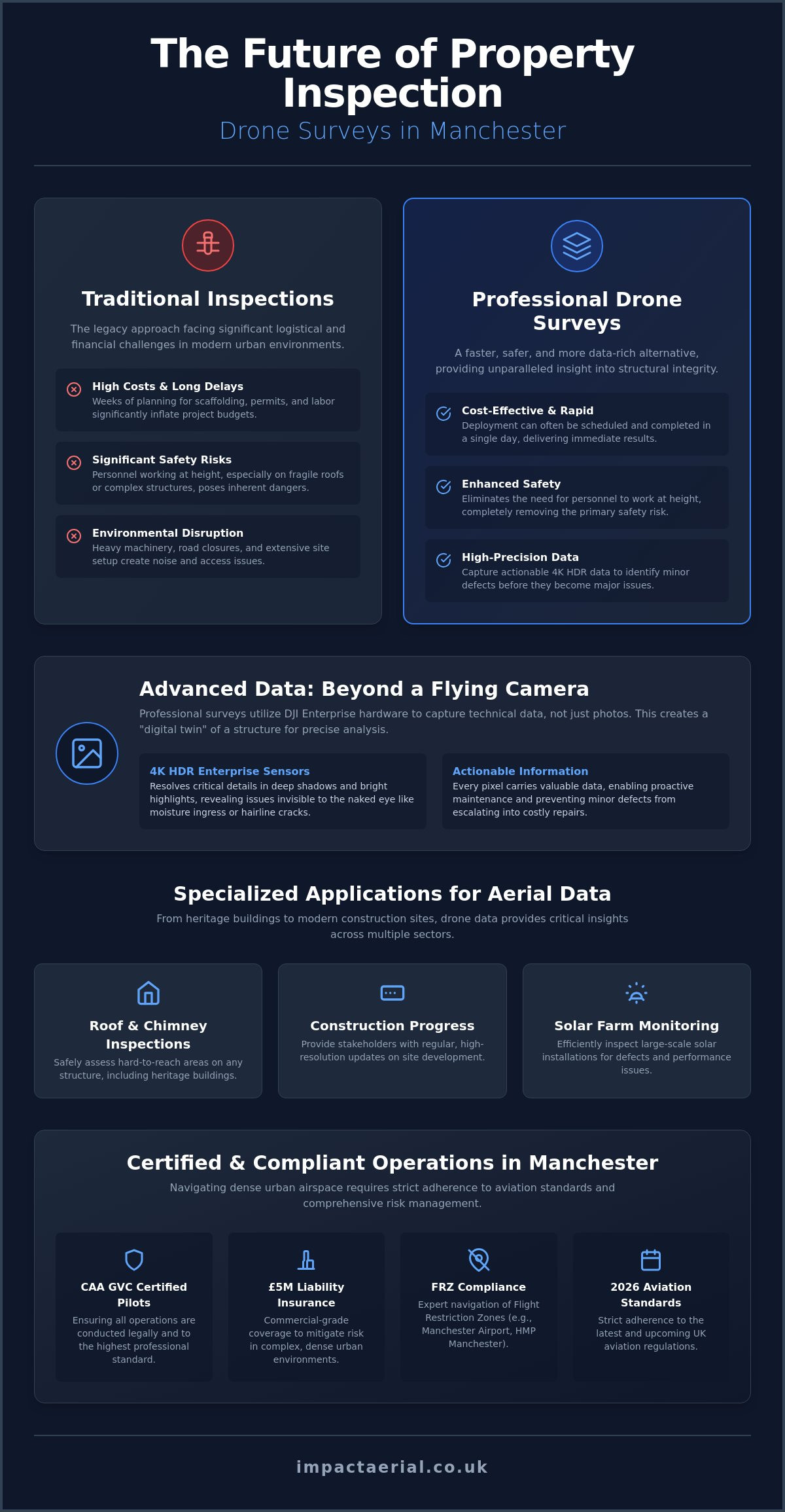
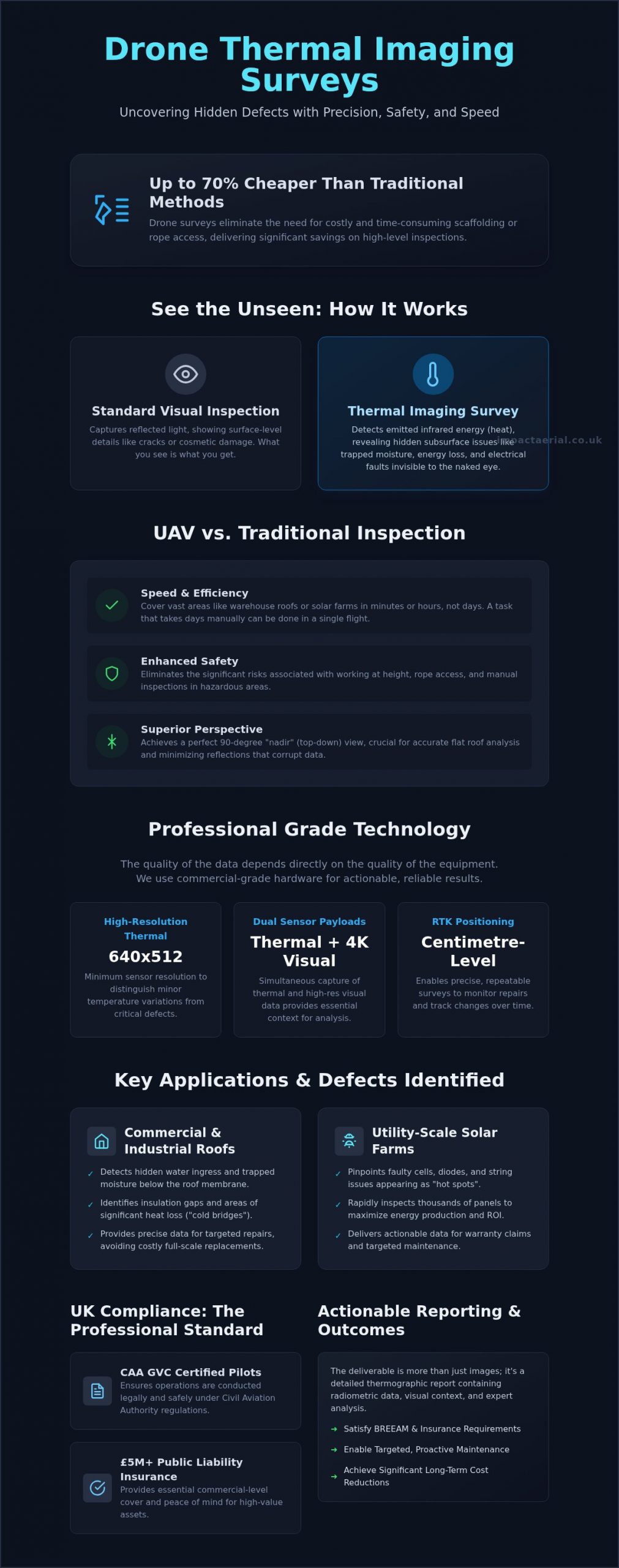
Did you know that professional drone surveys can be up to 70% cheaper than traditional inspection methods like scaffolding or rope access? For many commercial property managers and solar farm operators, the primary concern isn’t just the cost of access; it’s the invisible energy leaks and structural defects that remain hidden until they cause expensive downtime. You need a reliable way to inspect high-level assets without compromising on safety or risking the use of uncertified, under-insured pilots.
This guide explains how a drone thermal imaging survey UK identifies hidden moisture, energy loss, and solar faults with surgical precision. We’ll explore how CAA GVC certified pilots utilize commercial-grade DJI Enterprise hardware to deliver actionable thermographic data that satisfies both BREEAM and insurance requirements. You will learn how to secure a detailed, compliant report that provides the technical reassurance and long-term cost savings your business demands.
Key Takeaways
- Learn how non-destructive infrared sensors detect heat signatures and hidden defects invisible to the human eye from a safe distance.
- Understand why high-resolution sensors and commercial-grade DJI Enterprise hardware are essential for capturing accurate, actionable thermal data.
- Discover how a drone thermal imaging survey UK identifies specific issues like water ingress in commercial roofs and ‘hot spots’ on utility-scale solar farms.
- Identify the critical legal requirements, including CAA GVC certification and £5m liability insurance, necessary for compliant professional aerial inspections.
- Find out how detailed thermographic reporting provides the precise insights required for BREEAM compliance and significant long-term maintenance cost reductions.
What is a Drone Thermal Imaging Survey?
A drone thermal imaging survey UK is a specialized, non-destructive inspection method that utilizes Unmanned Aerial Vehicles (UAVs) equipped with high-resolution infrared sensors. Unlike standard photography, which captures the light reflected off a surface, thermal imaging detects the infrared radiation emitted by an object. This technology allows surveyors to visualize temperature variations across a structure, identifying anomalies that indicate underlying issues such as trapped moisture, insulation gaps, or electrical faults. It’s an essential tool for commercial property managers who require a comprehensive overview of their assets without the downtime associated with physical inspections.
The core benefit of this technology is its ability to detect heat signatures that are entirely invisible to the human eye. In a commercial context, this might reveal a “hot spot” on a solar panel or a “cold bridge” in a building’s envelope where heat is escaping. By capturing this data from a safe distance, drones eliminate the need for costly scaffolding or risky manual inspections at height. It isn’t just about taking pictures; it’s about gathering precise, technical data that informs long-term maintenance strategies and reduces operational risk.
There’s a significant difference between visual and thermal data. While a high-resolution visual camera can show you a crack in a roof tile, a thermal sensor reveals the damp insulation beneath it that has been festering for months. This layered approach to data collection provides a level of insight that traditional surveys simply cannot replicate, allowing for targeted repairs rather than expensive, site-wide replacements.
How Aerial Thermography Works
Thermal sensors convert infrared energy into a visual map known as a thermogram. Professional surveys rely on “Radiometric” data, which means the sensor records a specific temperature value for every single pixel in the image. This allows for detailed post-flight analysis where surveyors can interrogate the data to find exact temperature differentials. Accuracy depends heavily on technical calibration. Emissivity refers to the effectiveness of a material’s surface in emitting energy as thermal radiation, a variable that professional surveyors must calibrate to ensure data integrity. Without accounting for emissivity and atmospheric conditions, thermal data can be misleading or entirely inaccurate.
UAV vs. Traditional Thermal Surveys
Speed is one of the most immediate advantages of a drone thermal imaging survey UK. A warehouse roof that would take a surveyor days to inspect with a handheld camera can be covered in minutes from the air. Safety is equally paramount; by using drones, we remove the necessity for rope access or working at height, significantly lowering the risk profile of the project. Furthermore, drones provide the “nadir” or straight-down perspective. This 90-degree angle is crucial for flat roof surveys to minimize reflections and ensure the sensor captures the most accurate thermal signature possible across the entire surface area.
Advanced Technology: The DJI Enterprise Advantage
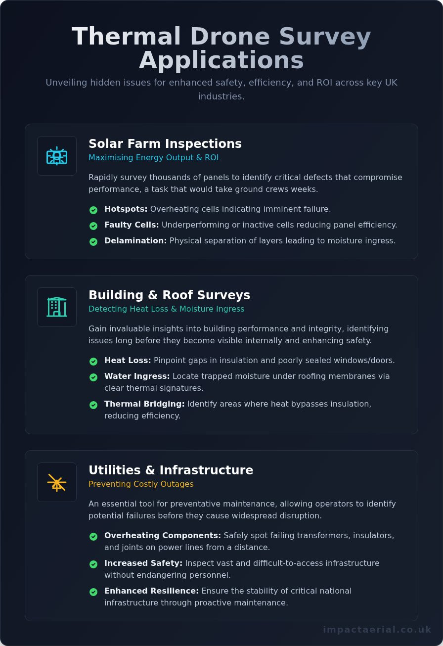
The success of a drone thermal imaging survey UK depends entirely on the caliber of the equipment used. While consumer drones might offer basic thermal capabilities, we utilize commercial-grade DJI Enterprise hardware to ensure the highest data integrity. These platforms are specifically designed for industrial applications, featuring high-resolution thermal sensors with a minimum of 640×512 resolution. This level of detail is critical; lower resolutions often fail to distinguish between minor surface temperature variations and genuine structural defects. By using professional sensors, we can identify anomalies as small as a single failing solar cell or a minor moisture leak behind a parapet wall.
Precision is further enhanced through dual-sensor capabilities and RTK (Real-Time Kinematic) positioning. Our drones capture high-resolution 4K visual imagery and thermal data simultaneously. This allows us to overlay the heat map onto a clear visual photograph, providing essential context for maintenance teams. RTK technology provides centimetre-level positioning accuracy, which is vital for repeatable surveys. If we identify a fault today, we can return to the exact coordinates months later to monitor the effectiveness of repairs. Ensuring that these advanced platforms are operated within the strict guidelines for UK Compliance, Safety, and Choosing a Provider is a core part of our operational philosophy.
The Importance of Delta T in UK Surveys
For a thermal survey to be accurate, there must be a sufficient temperature difference, known as Delta T, between the internal and external environments. In the UK, we typically require a Delta T of at least 10°C to 15°C for building envelope inspections. This makes the UK winter months and night-time operations the optimal window for survey work. Conducted after sunset, these surveys eliminate “solar loading,” where the sun warms the building surface and masks underlying defects. We carefully monitor wind speeds and surface moisture, as excessive wind can “wash away” heat signatures and rain can provide false readings due to evaporative cooling.
Radiometric Data and Reporting
Data captured during our flights is recorded in a radiometric JPEG format. This means every pixel in the image contains a specific temperature measurement that can be interrogated during post-production. Our technical team uses specialized software to analyze these heat maps, adjusting parameters like emissivity to produce a professional, actionable report. These insights are often integrated into broader drone property surveys to provide a complete digital twin of a commercial asset. If you are managing a large-scale facility, our team can help you assess your specific thermal requirements to ensure your next inspection delivers maximum value.
Key Applications for Drone Thermal Surveys in the UK
The versatility of a drone thermal imaging survey UK makes it an indispensable asset for diverse industrial sectors. From identifying energy inefficiencies in large-scale warehouses to monitoring critical infrastructure, the applications are as varied as they are vital. Operating these surveys requires strict adherence to UK Civil Aviation Authority drone regulations, particularly when navigating the complex airspaces surrounding industrial hubs or densely populated commercial zones. By integrating thermal data into standard maintenance workflows, organizations can transition from reactive repairs to a proactive, data-driven strategy.
In industrial facilities, thermal drones monitor steam pipe networks, electrical substations, and mechanical components for signs of overheating or wear. These hotspots often precede catastrophic failure, meaning a single flight could prevent thousands of pounds in lost production time. For building envelopes, thermography is a primary tool for verifying air leakage and insulation continuity, which is often required for BREEAM assessments or energy efficiency certifications. This technical oversight ensures that commercial assets remain compliant with evolving environmental standards while reducing operational overheads.
Solar Farm Efficiency and ROI
Maximizing the output of renewable assets is the primary goal of PV solar farm thermal surveys. Traditional manual testing of a utility-scale array can take weeks and involves significant labor costs. In contrast, a drone can inspect hundreds of acres in a single day, identifying bypass diode failures and string issues with absolute precision. It’s important to understand that a single faulty cell can degrade an entire string’s performance, leading to a disproportionate drop in total energy production. By pinpointing these defects early, operators can ensure their maintenance teams only replace what’s necessary, protecting the long-term ROI of the site.
Commercial Property and Flat Roofs
Flat roofs are notorious for hidden moisture entrapment, which often goes unnoticed until structural damage occurs. A drone thermal imaging survey UK identifies these wet areas by detecting the thermal mass of trapped water, which retains heat longer than dry insulation after sunset. This allows property managers to perform targeted patch repairs rather than commissioning a full roof replacement. For those looking to understand the broader context of aerial data, our drone survey guide explains how thermal data fits into a holistic asset management plan. Visualizing heat loss in this way provides the tangible evidence needed to justify energy-saving capital expenditures in large industrial warehouses.
UK Compliance, Safety, and Choosing a Provider
Compliance is the cornerstone of any professional drone thermal imaging survey UK. It isn’t merely a matter of following rules; it’s about rigorous risk mitigation and ensuring the safety of personnel and property. Every commercial flight must be preceded by a site-specific Risk Assessment and Method Statement (RAMS). These documents outline exactly how the pilot will manage hazards, from public footpaths to overhead power lines. Additionally, because thermal data can reveal sensitive information about a facility’s operations and security, professional providers must handle all data in strict accordance with UK GDPR standards.
Choosing a provider based solely on price often leads to significant legal and financial risks. A professional firm brings technical reassurance through meticulous operational standards. This includes maintaining detailed flight logs, equipment maintenance records, and up-to-date insurance certificates. When you hire an expert, you aren’t just paying for a thermal map; you’re investing in a compliant process that protects your business from liability.
Why CAA GVC Certification Matters
In the UK, the General Visual Line of Sight Certificate (GVC) is the standard legal requirement for pilots operating under an Operational Authorisation from the Civil Aviation Authority. Understanding the nuances of a drone license is vital for anyone commissioning commercial work. There’s a vast difference between a hobbyist flyer and a professional operator. Certified pilots have undergone rigorous theory and practical examinations to prove they can navigate complex UK airspace and urban environments safely. They understand how to coordinate with Air Traffic Control and other stakeholders, ensuring that your survey doesn’t interfere with local aviation activity.
Insurance and Liability
While many drone users carry basic insurance, £5m commercial liability insurance is the recognized gold standard for UK site access. Many industrial facilities, construction sites, and solar farms won’t grant gate access without proof of this specific level of indemnity. This coverage is essential because it protects the client, the public, and the property in the unlikely event of an incident. Using an under-insured or uncertified pilot exposes your organization to immense financial risk and potential breach of contract with your own insurers. Before commissioning a survey, always verify a pilot’s credentials and insurance validity. If you need a vetted partner for your next project, contact our certified team to discuss your requirements and receive a detailed safety brief.
Impact Aerial: Professional Thermal Solutions Across the UK
Based in Birmingham, Impact Aerial is strategically positioned in the West Midlands to facilitate rapid deployment for any drone thermal imaging survey UK. Our central location allows us to provide a consistent, high-tier service to commercial clients from Scotland to the South Coast. We combine the creative eye developed through years of professional aerial filming with the meticulous technical precision required for thermographic data collection. This unique blend of skills ensures that every survey we conduct isn’t just technically accurate, but also provides the visual clarity needed for stakeholders to understand complex findings quickly.
Our brand promise of reassurance and reliability is reflected in our choice to use only CAA GVC certified pilots and £5m commercial liability insurance. We don’t just provide raw data; we offer a technical partnership designed to reduce your operational risks. By handling every stage of the process in-house, we maintain total control over data quality and safety standards, giving you the peace of mind that your assets are in expert hands.
Our Survey and Reporting Process
Precision begins long before the drone leaves the ground. Our pre-flight phase involves rigorous weather monitoring and Delta T planning to ensure atmospheric conditions are optimal for thermal contrast. Once on-site, our pilots use DJI Enterprise hardware to capture radiometric data efficiently, minimizing disruption to your site operations. The most critical phase, however, is our post-production reporting. We translate complex heat maps into actionable PDF reports that feature side-by-side thermal and visual comparisons. This clear documentation allows your maintenance teams to see exactly where a defect is located in the real world, removing the guesswork from repairs and providing a verifiable audit trail for insurance or BREEAM compliance.
Book Your UK Thermal Drone Survey
Every commercial property or solar farm has unique requirements, which is why we start every project with a detailed consultation. We work with you to identify the specific questions you need the thermal data to answer, whether you’re chasing an elusive roof leak or auditing the efficiency of a utility-scale PV array. This targeted approach ensures that the final report delivers maximum value and tangible insights for your business. Our team is ready to provide a tailored quote based on your site’s scale and complexity. To secure technical reassurance for your assets, Contact Impact Aerial for a professional thermal imaging quote.
Maximise Operational Efficiency with Precision Thermography
A drone thermal imaging survey UK provides the technical clarity needed to protect commercial property and utility-scale solar farms from invisible defects. By leveraging high-resolution radiometric data, you can identify moisture ingress and electrical faults before they escalate into costly structural failures. The combination of DJI Enterprise hardware and meticulous Delta T planning ensures that every report delivers actionable insights rather than just raw imagery.
Choosing a certified partner is about more than just compliance; it’s about operational security. With our CAA GVC Certified Pilots and £5m Commercial Liability Insurance, we provide the reassurance and reliability required for complex industrial site access. Our Birmingham-based team is ready to deliver high-tier Actionable Radiometric Data Reports that support your long-term maintenance and BREEAM requirements across the UK.
Request a Professional Drone Thermal Survey Quote to start your next project with a trusted specialist. We’re here to help you turn invisible heat signatures into a clear strategy for asset protection.
Frequently Asked Questions
What is the best time of year for a drone thermal survey in the UK?
The winter months, typically between November and March, provide the optimal conditions for a drone thermal imaging survey UK. This period ensures a significant temperature differential between a building’s heated interior and the cold external environment. We often conduct these surveys at night or in the early morning to avoid solar loading, where the sun warms the building surface and masks underlying thermal anomalies.
How much does a drone thermal imaging survey cost?
The cost of a professional thermal survey is determined by factors like the total acreage of a solar farm or the complexity of a commercial roof structure. Larger industrial sites require more flight time and extensive data processing during the post-production phase. We provide bespoke quotes for every project to ensure the scope of work aligns with your specific technical requirements and the depth of reporting needed.
Can drones detect water leaks in flat roofs?
Drones are highly effective at detecting moisture entrapment within flat roof systems. Trapped water has a higher thermal mass than dry insulation, meaning it retains heat longer and creates a distinct thermal signature after sunset. This non-destructive method allows us to pinpoint the exact location of water ingress without invasive core sampling, helping property managers target repairs and avoid full roof replacements.
Is a drone thermal survey better than a handheld inspection?
Aerial surveys offer significant advantages over handheld inspections regarding perspective, safety, and speed. A drone captures the nadir, or straight-down angle, which is essential for accurate thermal mapping of flat roofs and large solar arrays. While a handheld camera is limited by ground-level obstacles, a UAV can survey an entire industrial facility in a fraction of the time while maintaining a consistent data-capture height.
Do I need to be on-site during the drone survey?
Client presence isn’t strictly required during the flight, provided our pilots have the necessary site access and safety clearances. We handle the pre-flight risk assessments and coordinate with your site manager to ensure minimal disruption to your operations. Once the flight is complete, we provide a full briefing and deliver the technical report digitally, allowing you to review the findings from any location.
What temperature difference (Delta T) is needed for a valid report?
A valid thermographic report typically requires a temperature difference of at least 10°C to 15°C between the internal and external environments. For building envelope surveys, this contrast is vital to ensure that heat loss or insulation gaps are clearly visible to the infrared sensor. We meticulously plan our flight windows around weather forecasts to ensure these technical conditions are met, providing the most accurate data possible.
Are your pilots CAA GVC certified?
Every pilot at Impact Aerial is CAA GVC certified, ensuring they meet the legal requirements for commercial drone operations in the UK. This certification, combined with our £5m commercial liability insurance, provides the professional reassurance needed for work on high-risk industrial sites. We maintain strict adherence to all aviation safety protocols, including the submission of site-specific risk assessments before every drone thermal imaging survey UK.
How long does it take to receive the thermal survey report?
We typically deliver our detailed thermographic reports within three to five business days following the site visit. This timeframe allows our technical team to process the radiometric data and overlay thermal findings onto high-resolution visual imagery. Each report is manually reviewed to ensure accuracy, providing you with a professional document that includes actionable insights and clear comparisons for your maintenance or insurance teams.