In 2026, a single non-compliant flight can cost your business significantly more in CAA fines than the entire production budget of your media campaign. You want that breathtaking 4K cinematic perspective to elevate your brand, but the technical jargon and evolving drone regulations often feel like a legal minefield. It’s stressful trying to choose a professional aerial filming company that balances creative flair with strict operational safety when your reputation is on the line.
We understand that you need both stunning visual assets and total regulatory peace of mind. This guide will show you exactly how to identify a partner that meets these high standards. We’ll help you evaluate the vital differences between A2 CofC and GVC licenses, the necessity of £5m commercial liability insurance, and the new Remote ID broadcast requirements. You’ll learn how to secure high-tier output and efficient project management while ensuring your production remains fully compliant from takeoff to post-production.
Key Takeaways
- Learn why the CAA GVC is the essential qualification for 2026 and how to verify a provider’s £5m commercial liability insurance for total risk mitigation.
- Understand how a professional aerial filming company manages the entire workflow, from 4K HDR capture to expert post-production, to ensure your project stays on budget and on brand.
- Discover the technical requirements for 2026, including mandatory Remote ID broadcasts and how they impact flight operations in controlled UK airspace.
- Identify the specific hardware capabilities needed for high-tier output, such as DJI Enterprise drones capable of cinematic marketing and technical property surveys.
- Master the selection criteria for choosing a partner that balances creative artistry with rigorous aviation safety standards across the West Midlands and the wider UK.
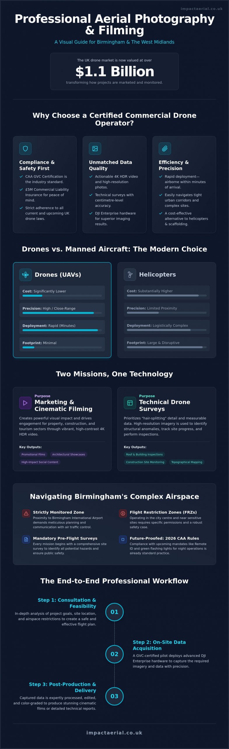
What Does a Professional Aerial Filming Company Actually Do?
A professional aerial filming company operates as a technical consultancy rather than a simple equipment hire service. While the history of aerial photography began with balloons and later transitioned to expensive, fuel-heavy helicopters, the modern industry relies on agile, high-specification drones. This shift has democratized the perspective but significantly increased the need for rigorous operational standards. Every flight is a managed project that integrates cinematic artistry with complex aviation law.
Output is driven by an Aerial Director of Photography (DOP) who understands how to translate a creative brief into precise flight paths. It’s not just about getting the drone in the air. It’s about managing light, framing, and movement to produce high-tier 4K HDR footage. This expertise ensures that the final media aligns perfectly with your marketing KPIs or technical requirements. For a professional aerial filming company, the drone is merely a tool used to achieve a specific, high-quality result under strict safety protocols.
To better understand the scale and precision involved in professional operations, watch this helpful video:
The Difference Between Amateur and Professional Drone Services
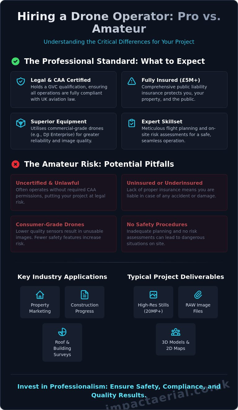
Owning a consumer drone doesn’t make someone a professional service provider. Professional companies use enterprise-grade hardware, such as the DJI Enterprise series, which offers superior stability in challenging UK weather. We focus on technical specifications like Log profiles and 10-bit colour depth. These allow for advanced colour grading in post-production, providing a cinematic look that basic 4K consumer footage simply cannot match. Reliability is key; professional systems have redundant batteries and advanced obstacle avoidance to protect both the project budget and the site.
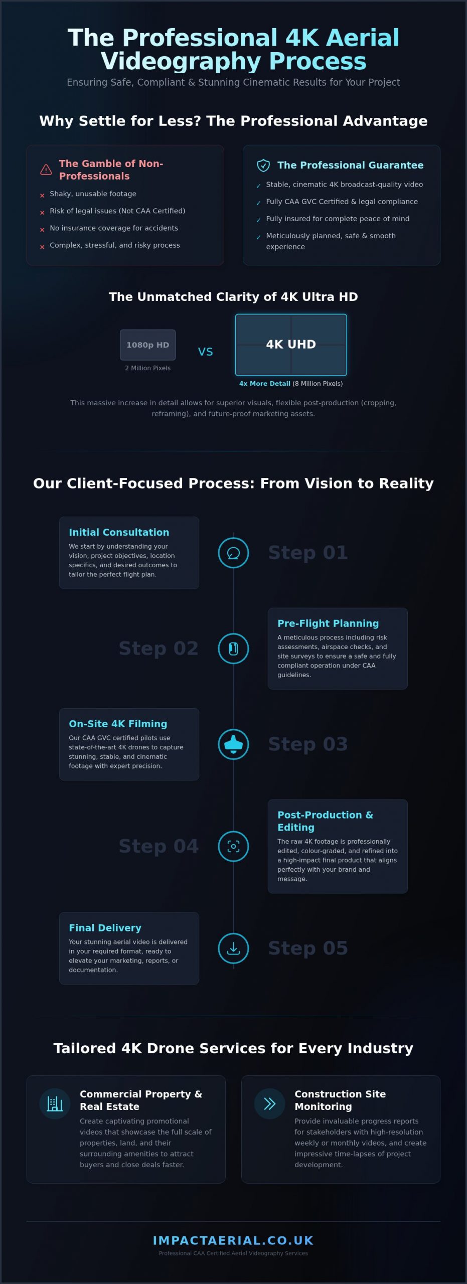
Beyond the Camera: Project Management and Planning
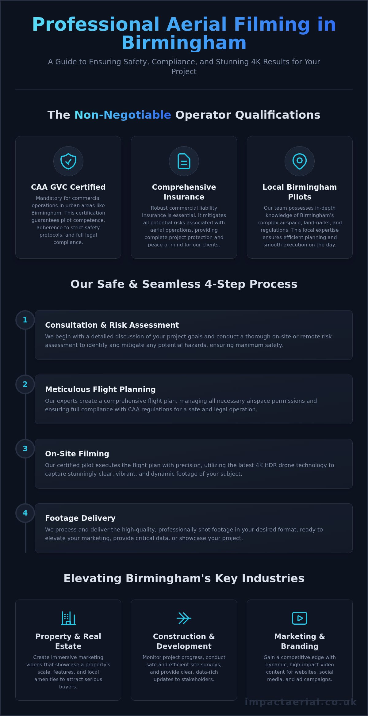
A significant portion of the work happens before the drone even leaves the ground. Meticulous pre-flight planning involves conducting site-specific risk assessments and securing necessary airspace permissions from the Civil Aviation Authority (CAA) or local air traffic control. We start with an initial consultation to define your project’s goals, whether it’s construction monitoring or high-end real estate marketing. This structured workflow ensures that every flight is legal, insured, and targeted toward delivering specific, actionable data or stunning visual content.
Core Services: From Cinematic Marketing to Technical Surveys
A professional aerial filming company provides more than just a camera in the sky; it delivers a suite of data-driven and creative solutions tailored to specific commercial outcomes. While many operators focus solely on the visual aesthetic, a comprehensive service provider bridges the gap between cinematic marketing and technical precision. This dual capability allows businesses to leverage aerial assets for everything from high-stakes advertising campaigns to granular construction site monitoring. By using DJI Enterprise hardware, we ensure that every frame captured is stable, high-resolution, and fit for purpose.
Aerial Filming for Property and Construction
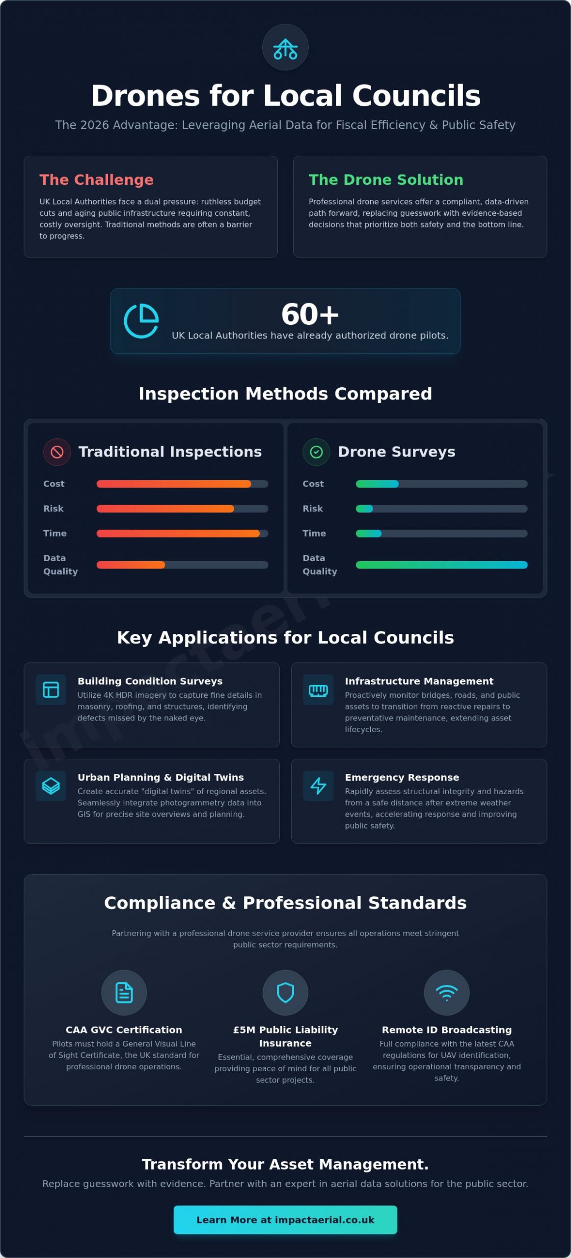
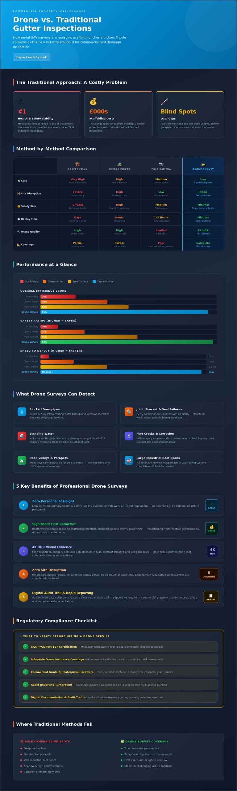
In the commercial sector, the application of drone technology has revolutionized how assets are managed and marketed. Using drone property surveys allows for incredibly detailed and safe roof inspections, removing the need for expensive scaffolding or high-risk manual climbing. For construction projects, drones provide stakeholders with regular, time-stamped visual updates that are essential for tracking progress against milestones. These operations must always adhere to the latest UK drone filming regulations to ensure that data collection doesn’t compromise site safety or legal standing. High-end real estate also benefits from this technical approach, as cinematic tours of commercial portfolios can significantly accelerate the sales cycle by providing a comprehensive sense of scale and location.
Post-Production: Turning Raw Footage into Impactful Content
The capture of 4K HDR footage is only the first step in the creative process. Post-production is the critical phase where raw 4K data and complex flight sequences are transformed into a persuasive narrative that drives audience engagement. This involves meticulous colour grading to ensure brand consistency and professional sound design that adds emotional depth to the visuals. Whether the final output is destined for a quick-hit social media campaign or a high-definition broadcast TV slot, the editing process ensures the pacing is perfect. A specialist aerial filming company will offer these services in-house to maintain quality control from the initial flight plan to the final export.
Modern businesses also utilize immersive virtual tours that seamlessly blend aerial perspectives with ground-based 360-degree views. This creates a cohesive journey for the viewer, whether they’re exploring a new tourism destination or a corporate campus. If you’re looking to elevate your next project with these capabilities, exploring the professional drone services available can help you determine the best approach for your specific needs. By integrating creative videography with technical surveys, you gain a versatile asset library that serves multiple departments within your organisation, from marketing to facilities management.
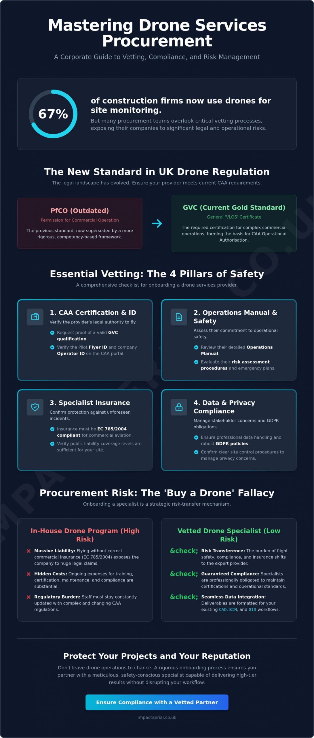
Safety and Compliance: The Legal Requirements for UK Drone Filming
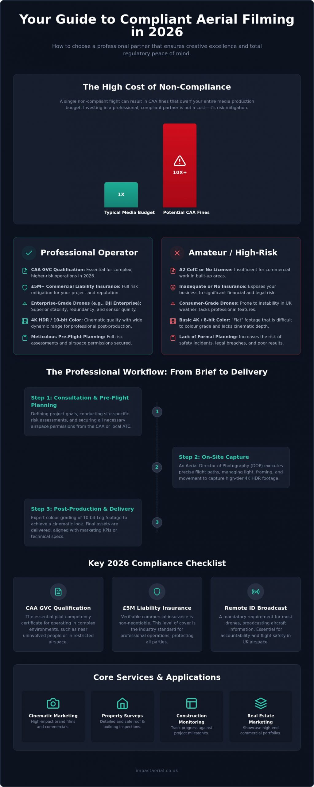
Operating as a professional aerial filming company in 2026 requires more than just technical skill; it demands a deep understanding of the Civil Aviation Authority (CAA) regulatory framework. As of January 1, 2026, all UK1, UK2, and UK3 class drones must broadcast their CAA-issued Remote ID. This transparency is a cornerstone of modern airspace management, ensuring that every commercial flight is traceable and accountable. For businesses, hiring an operator who bypasses these requirements isn’t just a safety risk; it’s a significant legal liability that can result in heavy fines and reputational damage.
Understanding Drone Licenses: GVC vs. A2 CofC
The distinction between drone certifications is critical for project safety. While the A2 CofC (Certificate of Competence) allows for basic operations, corporate clients should always insist on a CAA GVC certified pilot for complex commercial work. The General Visual Line of Sight Certificate (GVC) is the prerequisite for an “Operational Authorisation.” This permit allows a professional aerial filming company to fly in busier, more restricted environments that are often off-limits to basic flyers. If your project involves filming in built-up areas or near uninvolved people, the GVC provides the legal basis for the specific mitigations required to keep the shoot within the law.
Risk Mitigation and Insurance
A professional operation is defined by its approach to risk. Before any flight, we produce a comprehensive Risk Assessment & Method Statement (RAMS). This document outlines every potential hazard, from local obstacles to weather variables, and details the specific steps taken to neutralize them. Standard public liability insurance often excludes specialized drone activities, which is why we maintain £5m commercial liability insurance specifically tailored for aerial work. This level of coverage provides the financial reassurance that corporate legal departments require when authorizing high-profile shoots on site.
Safety also extends to data protection and ethical capture. We strictly adhere to privacy considerations for drone filming to ensure that our operations remain GDPR compliant. This includes managing how we capture, store, and process footage that may contain identifiable individuals or private property. By integrating these legal safeguards into our workflow, we provide a seamless service that protects your interests while delivering high-tier cinematic results. You don’t just get a pilot; you get a fully vetted aviation partner who prioritizes compliance as much as the final visual output.
How to Choose the Right Aerial Filming Partner for Your Project
Selecting a partner for your production isn’t just about finding someone with a drone; it’s about securing a technical consultant who understands your specific industry requirements. A methodical evaluation process ensures that your chosen aerial filming company can deliver high-tier cinematic results while maintaining full legal compliance. You should start by requesting a copy of their CAA Operational Authorisation and proof of £5m commercial liability insurance. If a provider cannot produce these documents immediately, they shouldn’t be operating on your site. Beyond the paperwork, you need to assess their project management style to ensure they can handle the complexities of a professional shoot from initial brief to final delivery.
Your evaluation should follow these five critical steps:
- Verify Credentials: Confirm their pilots hold a GVC and that their insurance is current and commercial-grade.
- Review the Portfolio: Look for industry-specific experience that matches your project’s goals.
- Assess the Technology: Ensure they utilize enterprise-grade hardware, such as DJI Enterprise drones, for maximum stability and image quality.
- Evaluate Communication: A professional partner will provide a clear workflow, including pre-flight planning and risk assessments.
- Compare Pricing: Look for transparent structures that clearly outline costs for permissions, flight time, and post-production.
Evaluating the Portfolio and Showreel
When reviewing a showreel, look beyond the initial visual impact. You should assess the variety of technical maneuvers, such as smooth orbits, dramatic reveals, and precise tracking shots. Pay close attention to the consistency of lighting and colour grading across different clips; this indicates a high level of control during both the capture and post-production phases. You should prioritize portfolios that feature projects similar in scale and industry to your own to ensure the team understands your specific visual language and operational constraints.
The Importance of Regional Expertise
Local knowledge is a significant asset when managing complex flight operations. A company with specific expertise in Birmingham and the West Midlands will already be familiar with local council requirements and police notification protocols for built-up areas. This regional insight helps streamline the permission process and reduces the risk of project delays. Additionally, hiring a UK-wide company with regional hubs offers the cost benefits of reduced travel expenses while providing pilots who understand local weather patterns and geographic challenges. If you’re ready to start your project with a vetted team, you can contact our professional drone pilots to discuss your specific requirements and receive a transparent quote.
Impact Aerial: Professional Drone Filming and Surveys Across the UK
Impact Aerial operates as a specialized aerial filming company that bridges the gap between high-end cinematic production and rigorous technical data collection. Based in Birmingham and the West Midlands, our team provides comprehensive UK-wide coverage for clients who require absolute precision. We don’t just capture images; we provide a managed aviation service that prioritizes safety and regulatory compliance above all else. By utilizing DJI Enterprise hardware, we deliver 4K HDR cinematic results that meet the exacting standards of modern marketing and industrial surveying.
Our pilots are all CAA GVC certified, ensuring they possess the highest level of qualification for commercial operations in complex environments. This expertise is backed by £5m commercial liability insurance as standard, providing the psychological comfort and financial security required by large corporate entities. Whether you’re looking for creative drone photography to elevate a brand or a technical survey to monitor site progress, our methodology remains consistent: meticulous planning followed by flawless execution. We understand the specific needs of the West Midlands region while maintaining the capacity to deploy our expertise across any UK location.
Our Approach to Your Project
Our workflow is designed to be methodical and transparent. It begins with an initial consultation where we define your specific KPIs, whether you’re in the property, construction, or advertising sector. We handle all pre-flight planning, including site-specific risk assessments and airspace permissions, so you don’t have to manage the regulatory burden. Once the flight is complete, our bespoke post-production services take over. We transform raw data into a polished, persuasive narrative through professional colour grading and sound design, ensuring the final output is ready for immediate deployment across your chosen platforms. This commitment to high-end visual output ensures that every project we undertake adds tangible value to your business.
Get a Professional Perspective Today
Choosing the right partner for your aerial filming drone operations is a decision that impacts both your project’s quality and its legal standing. Impact Aerial provides a reliable, expert-led solution that removes the guesswork from drone services. We invite you to reach out for a tailored consultation to discuss how our cinematic and technical capabilities can benefit your next project. Our team is ready to provide the professional perspective your business deserves. Contact Impact Aerial for a quote on your next project.
Elevate Your Production with Professional Aerial Standards
The landscape of aerial media in 2026 demands a sophisticated blend of creative vision and strict technical compliance. Selecting a professional aerial filming company is no longer just about the visual aesthetic; it’s about prioritizing safety through CAA GVC certification and ensuring your assets are protected by robust £5m commercial liability insurance. You now understand how the right partner manages the entire workflow, from navigating complex Remote ID requirements to delivering polished 4K HDR post-production that aligns with your brand’s KPIs.
Based in Birmingham and serving the entire UK, Impact Aerial provides the meticulous project management and high-tier output your business requires to stand out in a competitive market. We bridge the gap between stunning cinematic marketing and precision technical surveys, ensuring every flight is legal, insured, and productive. We invite you to request a bespoke quote for your aerial filming project and discover the difference that expert aviation standards can make. We look forward to helping you achieve a unique perspective on your next project with confidence and clarity.
Frequently Asked Questions
Is it legal to hire a drone filming company in the UK?
Yes, it’s entirely legal to hire a professional aerial filming company provided they hold a valid Operational Authorisation from the Civil Aviation Authority (CAA). You must verify that the pilots are GVC certified and that the business has the correct commercial insurance in place. Hiring an unlicensed operator can result in significant legal liabilities and heavy fines for your organization.
How much does a professional aerial filming company cost?
The cost of hiring an aerial filming company depends on several factors including the project duration, the technical complexity of the flight, and the level of post-production required. While basic sessions are available for smaller projects, high-end commercial productions involving specialized enterprise hardware and complex airspace permissions require a bespoke quote. We provide transparent pricing structures that account for all safety planning and regulatory filings.
What kind of insurance should a drone filming company have?
A professional provider must carry specialized commercial drone liability insurance rather than standard public liability cover. Most corporate sites and local authorities require a minimum of £5m in coverage to account for potential risks in built-up areas. This insurance provides essential protection for both the operator and the client, ensuring that all activities are financially secured against unforeseen incidents.
Can drones fly in rain or high winds in the UK?
Modern enterprise drones can operate in varied conditions, but safety remains the primary factor. Most professional systems have an IP rating that allows for flight in light rain, though heavy downpours can affect image quality and safety. Wind limits are typically around 22mph for stable cinematic capture. We always monitor live weather data to ensure every flight remains within safe operational parameters.
Do I need a special permit for drone filming in London or Birmingham?
Yes, filming in major cities often requires specific permissions due to Flight Restriction Zones (FRZs) and congested area regulations. We manage the entire application process, coordinating with local air traffic control and city councils to secure the necessary flight permits. Our regional expertise in Birmingham and the West Midlands allows us to navigate these local requirements efficiently for our clients.
What is the difference between a standard drone and an enterprise drone?
Enterprise drones are built for reliability and high-tier output, featuring redundant batteries and advanced obstacle avoidance sensors. Unlike consumer models, these systems offer superior 4K HDR capture and Log profiles that are essential for professional colour grading. They also include the mandatory Remote ID broadcast technology required for legal commercial operations in the UK throughout 2026.
How long does a typical aerial filming shoot take?
A typical shoot can range from a half-day session for simple site monitoring to multiple days for complex cinematic productions. We factor in time for initial site safety briefings, equipment setup, and multiple battery swaps to ensure we capture all required angles. The total duration is always defined during the initial consultation to ensure your project stays on schedule.
What video formats can you provide for post-production?
We deliver high-resolution 4K HDR footage in professional formats such as ProRes or h.265, depending on your editing requirements. By capturing in Log profiles, we provide maximum dynamic range for your post-production team to achieve a cinematic look. We can also provide fully edited, brand-ready content optimized for social media, corporate presentations, or broadcast television.