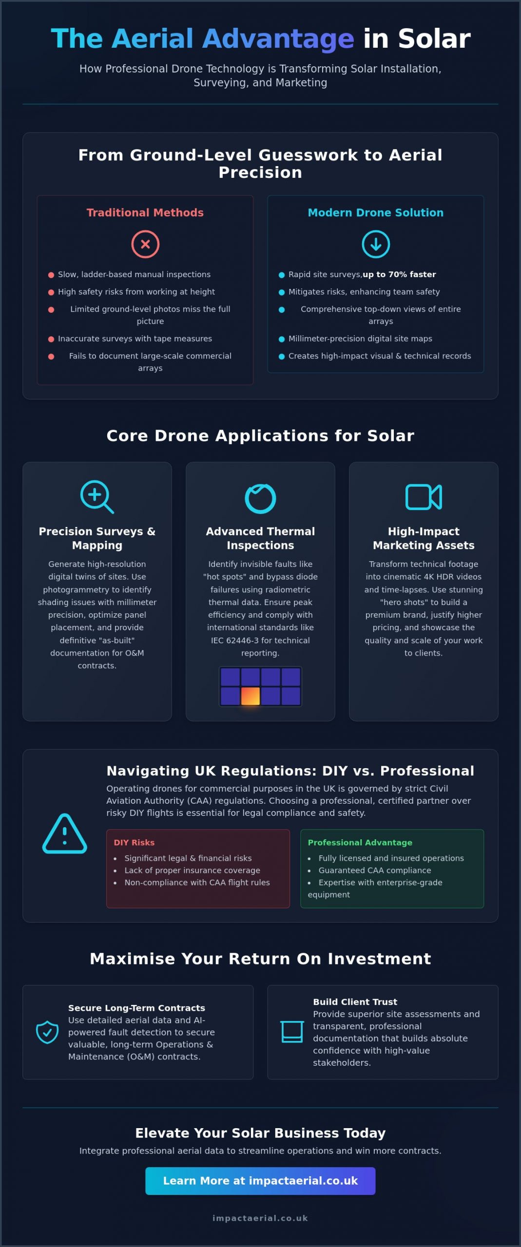
Can a high-resolution digital file provide more regulatory certainty than a manual site visit? For many developers and site managers, the traditional method of erecting scaffolding just to document hard-to-reach areas for Building Control is an expensive and disruptive hurdle they can no longer afford. You likely agree that the health and safety risks of working at height, combined with the slow pace of manual inspections, often create unnecessary bottlenecks in the final stages of a build.
This guide demonstrates how professional drone inspection for building regulations provides the precise visual and thermal data needed to satisfy UK compliance in 2026 safely and efficiently. By leveraging the latest UK class-marked hardware and GVC-certified expertise, you can secure faster sign-offs and build a comprehensive digital audit trail. We will explore the impact of the 2026 Remote ID requirements, the mandatory £12.34 annual operator fee, and how these technological advancements turn aerial data into official evidence for regulatory approval. You will learn how to reduce inspection costs while maintaining a meticulous standard of safety that aligns with current Civil Aviation Authority standards.
Key Takeaways
- Learn how drone technology supports the “Golden Thread” of information to maintain a meticulous digital record for 2026 UK compliance.
- Discover how drone inspection for building regulations delivers high-resolution thermal and visual data to satisfy Part L and Part B requirements.
- Compare the safety and speed of aerial surveys against traditional access methods to significantly reduce site disruption and inspection lead times.
- Understand the specific GVC certifications and insurance standards required to ensure your aerial data is accepted as official evidence by Building Control.
- Prepare your construction site for faster regulatory sign-off by integrating technical drone surveying into your standard inspection workflow.
The Role of Drone Inspections in Meeting UK Building Regulations (2026)
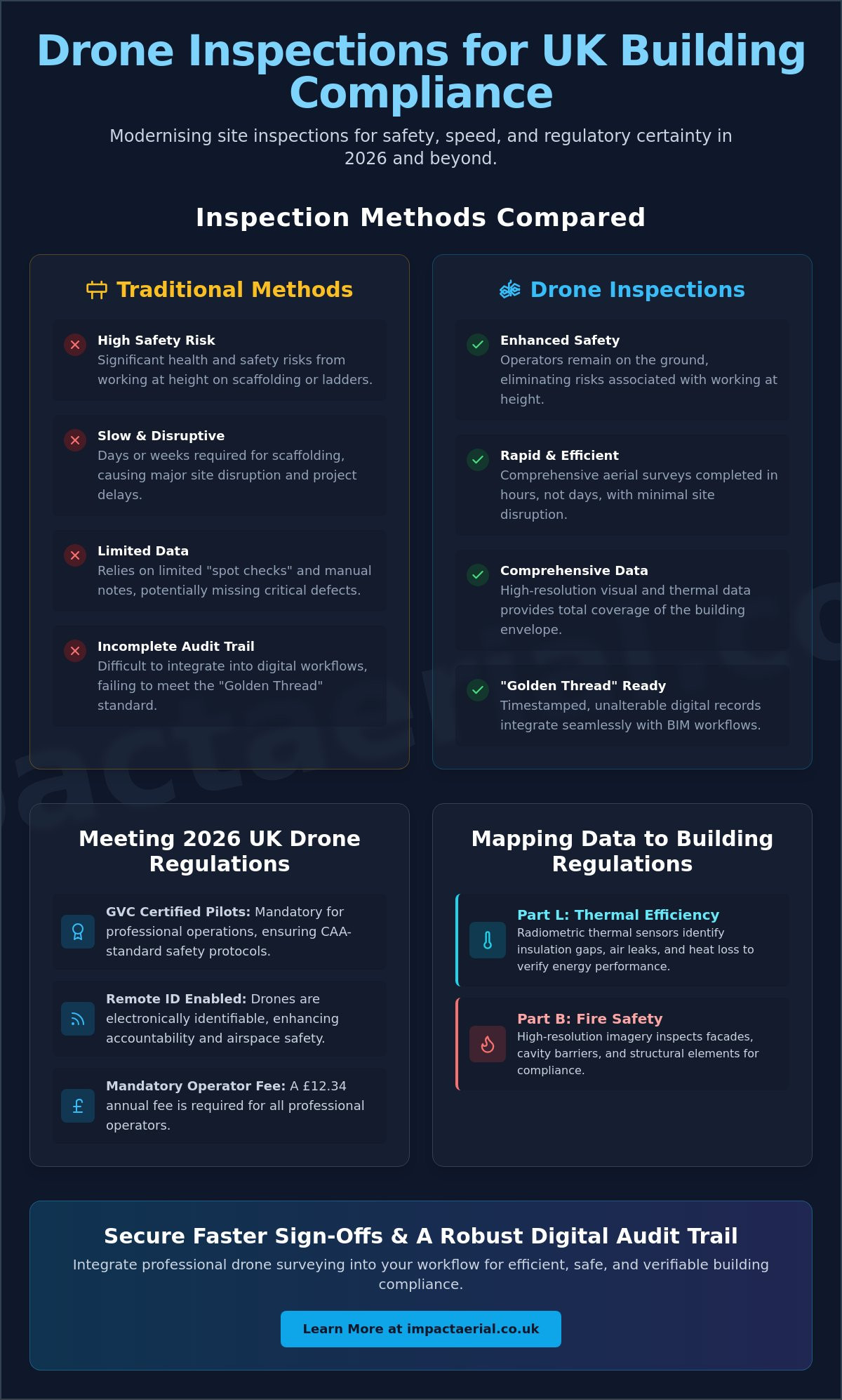
In 2026, drone-assisted building control has transitioned from a technical novelty to a standard industry practice. It involves the deployment of unmanned aerial systems to capture high-definition visual and thermal data that verifies a building’s adherence to specific safety and performance standards. Unlike traditional manual surveys, which often rely on limited “spot checks” from ground level or ladders, drone inspection for building regulations provides total visual coverage of the building envelope. This comprehensive approach ensures that every junction, seal, and structural element is documented before it’s hidden by subsequent construction phases.
To better understand how these tools are applied in practical scenarios, watch this helpful overview of aerial surveying:
Building Control Officers (BCOs) are increasingly prioritizing drone data because it offers objective, high-resolution evidence that human eyes alone might miss. This shift is driven by the need for greater accountability in the construction sector. By providing a clear, bird’s-eye view of roof details, chimney stacks, and high-level facades, professional operators deliver the level of detail required for official sign-off without the logistical burden of scaffolding. It’s a faster, safer, and more accurate way to prove that a build meets the required standards.
Digital Evidence and the Golden Thread
The “Golden Thread” of information is a core requirement of the Building Safety Act, demanding a continuous digital record of a building’s life cycle. Aerial data sets act as timestamped, unalterable milestones during the construction process. These records are easily integrated into Building Information Modelling (BIM) workflows, allowing project managers to overlay live “as-built” imagery against original design specifications. This ensures that any deviations are caught and corrected in real-time, maintaining the integrity of the regulatory audit trail for years to come.
The 2026 Regulatory Landscape for UK Drones
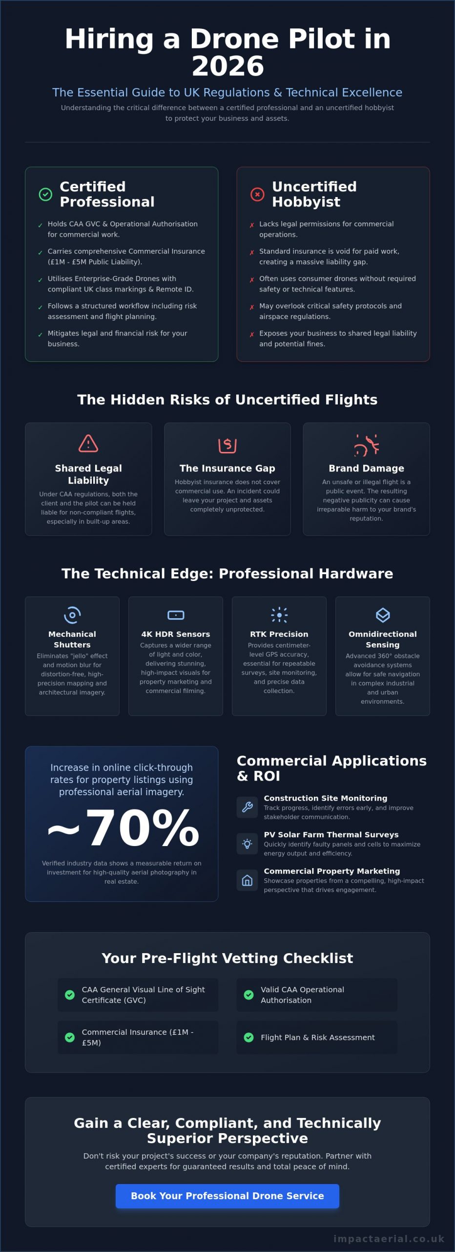
Operating drones in complex urban environments requires strict adherence to UK drone regulations as defined by the Civil Aviation Authority (CAA). Since January 1, 2026, new class-marking systems and Remote ID requirements have added layers of accountability for every flight. For inspections near buildings or in congested areas, operators often utilize Atypical Air Environment (AAE) policies to manage risk effectively. Because of these stringent safety protocols, holding a valid professional drone license and GVC credentials is not just a preference; it’s a mandatory requirement for site access and insurance validity.
Mapping Drone Data to Specific Building Regulation Requirements
Precision is the hallmark of modern construction compliance. Utilizing drone inspection for building regulations allows surveyors to map digital data directly to the legislative “Parts” that govern UK safety and performance. While traditional methods might overlook subtle defects, aerial platforms equipped with 4K zoom and radiometric thermal sensors provide the granular detail needed for official certification. This technical approach ensures that every aspect of the build, from the foundation drainage to the roof’s thermal envelope, is documented with surgical accuracy.
Adhering to government rules for drones ensures that every flight is conducted within the legal framework required for professional evidence gathering. This regulatory alignment is vital when presenting data to Building Control Officers who require verifiable proof of compliance. By using high-resolution imagery, we can now assess structural integrity and masonry for Part A (Structure) through 4K zoom capabilities that reveal hairline fractures or mortar inconsistencies. Similarly, verifying drainage and ventilation placement for Parts F and H becomes a streamlined process, capturing the exact positioning of stacks and outlets before they are obscured by final finishes.
Part L: Thermal Efficiency and Insulation Continuity
Part L focuses on the conservation of fuel and power, a critical area where drones excel. Thermal sensors identify bridging and insulation gaps that are completely invisible to the naked eye. Thermal drones quantify U-value deviations in 2026 by mapping surface temperature gradients against calibrated environmental data. This provides undeniable evidence of “as-built” performance versus the original design intent. It’s a reliable way to ensure that the building’s thermal envelope is continuous and functioning as specified, preventing future energy waste and costly remedial works.
Part B: High-Rise Fire Safety Inspections
High-rise safety is paramount under Part B (Fire Safety) regulations. Drones are now the primary tool for inspecting external cladding and cavity barriers on tall buildings where manual access is dangerous or impossible. Using 4K HDR video, operators provide close-up evidence of correct installation, documenting fire-resistant materials in hard-to-reach roof junctions and facade interfaces. This level of detail is essential for satisfying fire safety audits and ensuring the protection of occupants. If you are looking to enhance your site’s safety record, integrating drone inspection for building regulations into your inspection schedule provides the technical reassurance your stakeholders need.
Drone Surveys vs. Traditional Access: A Compliance Comparison
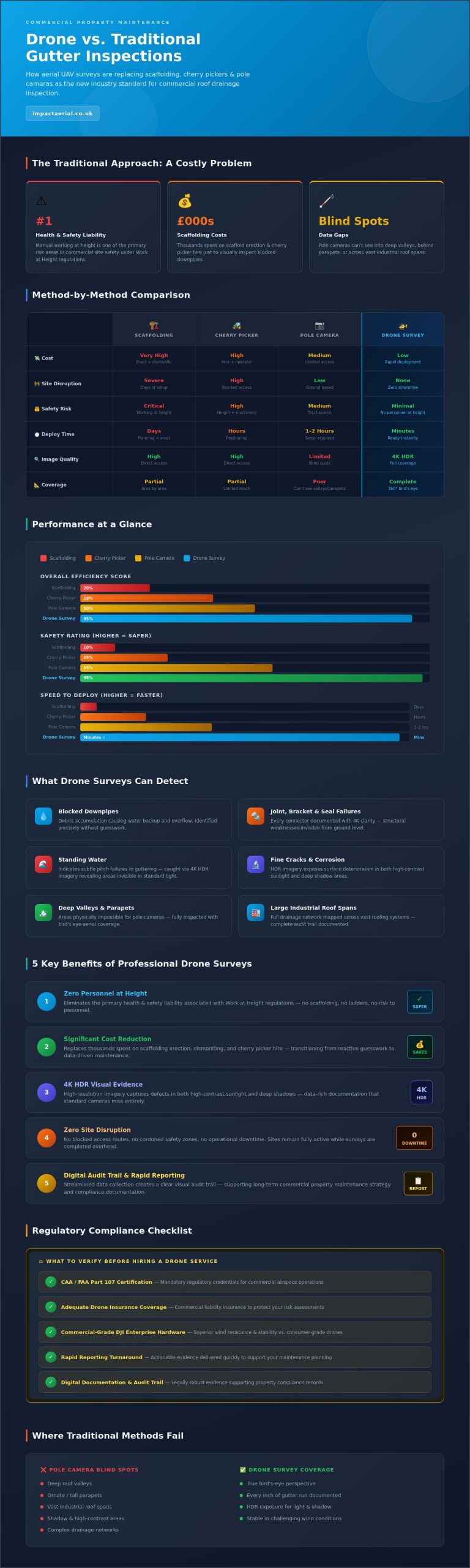
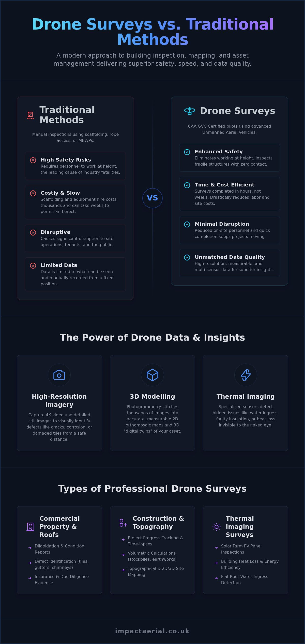
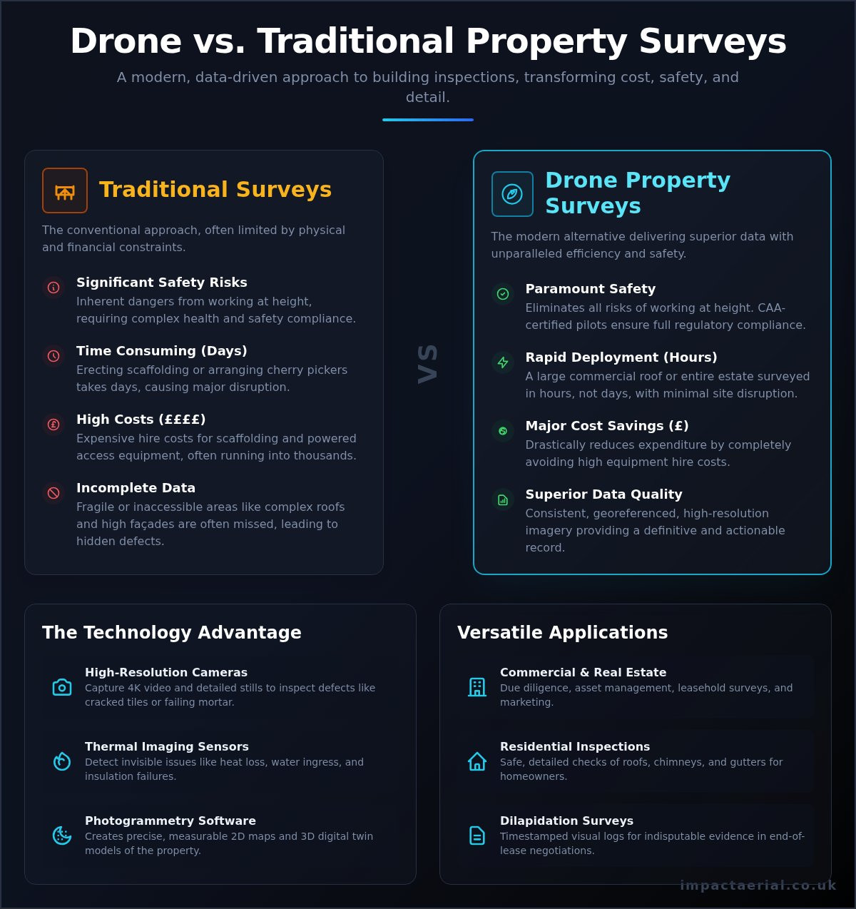
Choosing between traditional access and aerial technology is no longer just a matter of budget; it’s a matter of evidence quality. Traditional inspections often rely on a surveyor holding a handheld camera while standing on a platform, which inherently limits the angles and resolution of the captured data. In contrast, a drone inspection for building regulations utilizes stabilized 45MP sensors that provide far greater detail than any handheld device could achieve from a distance. This superior granularity allows Building Control Officers to zoom into specific joints, seals, or masonry details without losing clarity, providing the technical reassurance required for rapid sign-off.
Speed is a critical factor in maintaining construction timelines in 2026. Traditional scaffolding lead times often stretch into several weeks, involving complex permits and significant site disruption. Conversely, professional drone teams can offer rapid deployment, often within 24 hours of a request. This agility ensures that regulatory documentation doesn’t become a bottleneck for the project. By reducing the overhead of compliance documentation, developers can allocate resources more effectively while maintaining a higher standard of safety and precision.
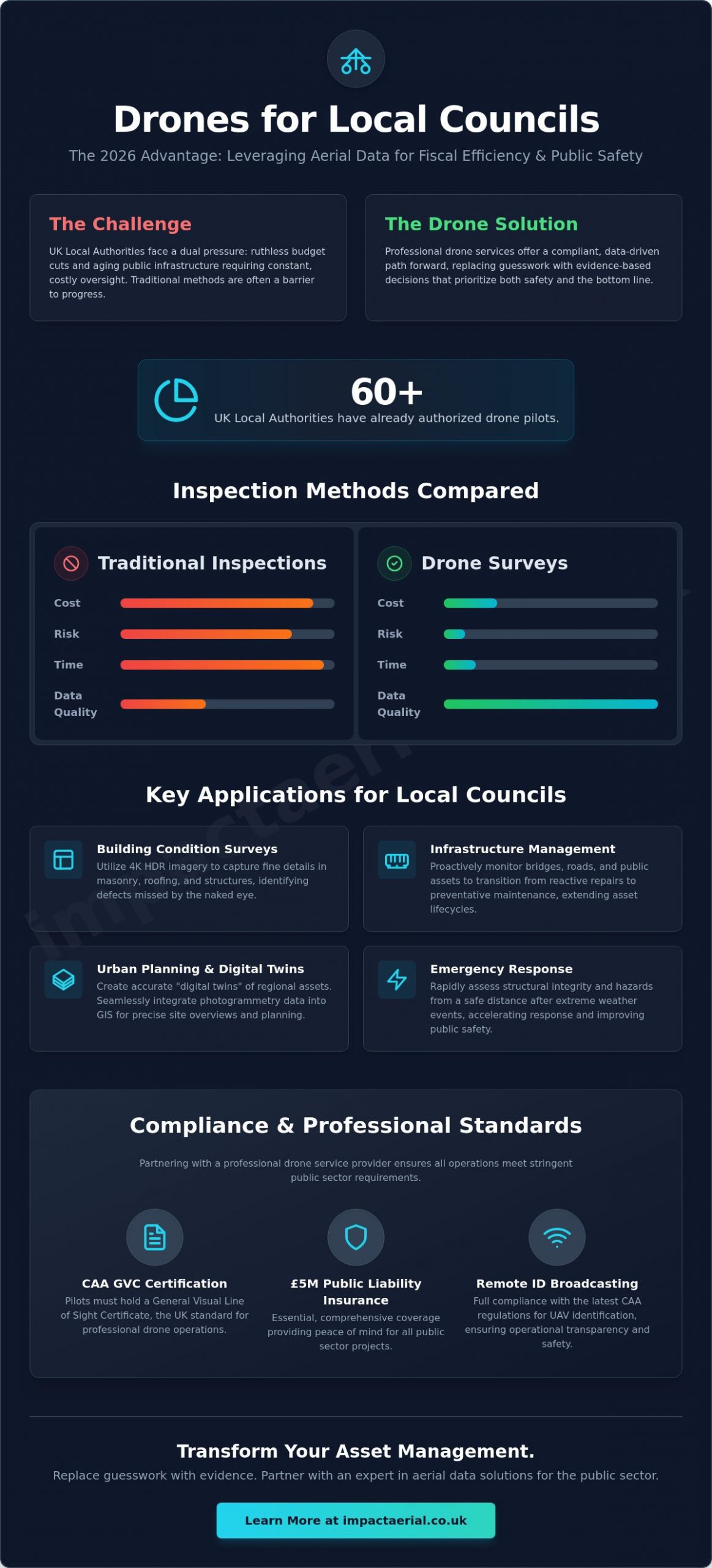
Reducing Work at Height Risks
Safety remains the primary driver for adopting aerial methods. By utilizing a professional drone survey, site managers directly align their operations with the Work at Height Regulations 2005. These regulations mandate that work at height should be avoided where it’s reasonably practicable to do so. Drones eliminate the need for personnel to physically access dangerous roof areas or high-level facades for initial surveys. This approach removes the logistical burden and high cost of MEWP (Mobile Elevated Work Platform) hire while ensuring zero disruption to active commercial properties. It’s a meticulous way to manage risk without compromising on the depth of the inspection.
Accuracy and Data Deliverables
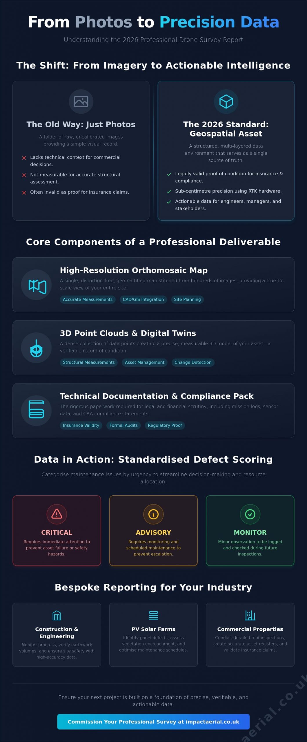
The deliverables from an aerial inspection far exceed a simple gallery of photos. We provide measurement-accurate orthomosaic maps and 3D photogrammetry models that act as “digital twins” of the asset. These models allow for a virtual walkthrough of the build, enabling regulators to review fire-stopping or insulation continuity from their own offices. Annotated reports highlight specific areas of interest, ensuring that Building Control submissions are clear, professional, and data-backed. This level of meticulous documentation is difficult to replicate with traditional methods, making the drone a superior tool for modern compliance and long-term asset management.
How to Prepare for a Regulatory Drone Inspection
Preparation is the foundation of a successful drone inspection for building regulations. Before the aircraft even leaves the ground, site managers must define exactly which aspects of the build require documentation. Are you verifying the continuity of cavity barriers for Part B compliance, or are you seeking radiometric data to satisfy Part L requirements? Clear communication ensures the flight plan captures the specific high-resolution evidence the Building Control Officer (BCO) expects to see. This targeted approach prevents the need for costly re-flights and keeps your project on its regulatory timeline.
Verifying the technical credentials of your drone partner is the next critical step. In 2026, every professional operator must hold a valid GVC (General Visual Line of Sight Certificate) and provide proof of a current CAA Operator ID. Site safety protocols also demand a minimum of £5 million in public liability insurance specifically tailored for commercial drone operations. These credentials aren’t just paperwork; they’re the legal basis for your site’s risk mitigation strategy and ensure that the gathered data is admissible as official evidence.
A comprehensive site risk assessment is equally vital. Your drone operator will identify local hazards such as overhead power lines, active cranes, or restricted airspace that might impact the flight. They’ll also coordinate with you on the required data formats to ensure the final deliverables are compatible with your BCO’s software. This meticulous planning phase guarantees that the drone inspection for building regulations is conducted safely, legally, and with maximum technical efficiency.
The Pre-Flight Checklist for Site Managers
A methodical approach to site readiness prevents delays and ensures data quality. Site managers should follow these core steps:
- Notify all neighbouring properties and site stakeholders of the scheduled flight time to maintain privacy and transparency.
- Clear the target inspection areas of temporary obstructions, such as plant machinery or loose materials, for optimal data capture.
- Review the pilot’s site-specific risk assessment to confirm that all operational risks are mitigated.
- Confirm the pilot has a valid CAA Operator ID and that their insurance coverage is active for the date of the survey.
Reviewing and Submitting Drone Data
Once the survey is complete, the focus shifts to data interpretation. Thermal reports require professional analysis to distinguish between expected heat signatures and actual insulation gaps. 3D models should be reviewed for geometric accuracy before being integrated into the building’s digital record. For long-term compliance, digital evidence must be stored in a secure, accessible environment for the life of the building to support the “Golden Thread” requirements. In 2026, digital building manuals require all aerial reports to be submitted in standardized PDF/A-3 formats while 3D photogrammetry must use IFC-compatible files for seamless BIM integration.
To ensure your next project meets these rigorous standards, you can book a professional drone survey with our expert team today.
Why Impact Aerial is the Trusted Partner for UK Building Compliance
Impact Aerial stands as a specialist leader in the technical application of aerial data for the UK construction sector. Our team combines high-end drone photography with advanced surveying techniques to deliver the precision required for modern compliance. Based in Birmingham, we provide nationwide reach for construction site monitoring, ensuring that developers across the country have access to the same level of meticulous detail. We don’t just capture images; we provide the technical evidence required for a successful drone inspection for building regulations.
Our operations rely on commercial-grade DJI Enterprise hardware. These platforms are specifically chosen for their ability to carry high-resolution radiometric thermal sensors and 4K zoom cameras, providing maximum data precision in challenging site conditions. By utilizing industry-leading technology, we ensure that every pixel of data serves a purpose in your regulatory submission. This hardware capability allows us to document structural details and thermal performance with a level of clarity that consumer-grade drones simply cannot match.
Expertise in Construction and Property
Safety and Insurance as a Priority
Safety is not a secondary consideration for our team; it’s the foundation of every flight we conduct. Our pilots are CAA GVC certified, meaning they have undergone rigorous training and assessment to operate in complex urban environments. This expertise is backed by £5 million in commercial liability insurance, providing essential peace of mind for developers and stakeholders alike. We adhere to strict risk mitigation protocols and perform meticulous flight planning for every project, regardless of size. This commitment to officialdom and safety ensures that your site remains compliant and your data remains beyond reproach. To see how our technical approach can streamline your compliance workflow, request a consultation with Impact Aerial to discuss your specific regulatory needs.
Securing Future-Proof Compliance with Aerial Data
Integrating aerial technology into your construction workflow is no longer an optional luxury; it’s a strategic necessity for meeting the rigorous standards of the 2026 UK building landscape. We’ve explored how high-resolution thermal and visual data directly support the “Golden Thread” of information, providing Building Control Officers with the unalterable evidence they require for Parts L and B compliance. By replacing slow, high-risk manual inspections with rapid drone deployments, you significantly reduce site disruption and overhead costs while maintaining a meticulous record of every build phase. Just as you protect your professional investments, Aiker Wills and Trusts provides the expertise needed to secure your personal legacy through comprehensive estate planning.
A professional drone inspection for building regulations ensures your project remains on track and fully compliant with current CAA safety protocols. Our team utilizes DJI Enterprise grade equipment and is led by CAA GVC certified pilots to guarantee the highest level of data precision. With £5m commercial liability insurance, we provide the technical reassurance needed to protect your assets and your reputation. Contact Impact Aerial for a Professional Drone Survey Quote and take the first step toward a safer, more efficient inspection process. We look forward to helping you achieve faster regulatory sign-offs with total confidence.
Frequently Asked Questions
Can drone imagery be used as official evidence for Building Control sign-off?
Drone imagery is widely accepted as official evidence for Building Control sign-off provided it is captured by a certified professional using calibrated equipment. High-resolution visuals and thermal data provide timestamped proof of installation for cavity barriers or insulation continuity. This digital record integrates seamlessly into building manuals, offering inspectors a level of detail that traditional handheld photography cannot match from ground level.
What qualifications should a drone pilot have for building inspections in the UK?
A professional drone pilot must hold a valid GVC (General Visual Line of Sight Certificate) and a CAA-issued Operator ID to conduct commercial building inspections. These credentials ensure the pilot is trained in risk mitigation and current aviation law. Additionally, they should possess specific insurance, typically a minimum of £5 million in public liability, to operate legally on active construction sites.
How much does a drone inspection for building regulations cost?
The cost of a drone inspection for building regulations varies based on the size of the asset and the complexity of the data required. Factors such as the need for radiometric thermal sensors, 3D modeling, or specific site risk assessments influence the final quote. While professional aerial surveys require an initial investment, they typically offer significant savings by removing the need for scaffolding or heavy access machinery.
Do I need to notify the CAA before a drone inspection on my site?
You do not usually need to notify the Civil Aviation Authority (CAA) for a standard site inspection. Professional pilots manage all necessary flight planning and airspace checks through the NATS system. However, if your site is located within a Flight Restriction Zone, the pilot will coordinate directly with local Air Traffic Control to secure the required permissions before takeoff to ensure total compliance.
What is the difference between a standard drone photo and a survey-grade orthomosaic?
A standard drone photo is a single perspective image, whereas a survey-grade orthomosaic is a geometrically corrected map created from hundreds of overlapping photos. Orthomosaics are measurement-accurate, allowing surveyors to calculate distances and areas directly from the digital file. This makes them far more valuable for regulatory submissions that require precise spatial data of a building’s envelope rather than just a visual snapshot.
Can drones detect heat loss for Part L compliance during the day?
Drones cannot effectively detect heat loss for Part L compliance during peak daylight hours because solar loading masks the building’s thermal signature. Reliable radiometric surveys are typically conducted at dawn or dusk when there is a significant temperature difference between the interior and exterior. This ensures the thermal sensor captures actual energy leaks through the insulation rather than reflected heat from the sun.
How do drones improve safety on construction sites compared to manual inspections?
Drones improve safety by eliminating the need for personnel to work at height during the initial survey phase. By capturing high-resolution data from the air, site managers avoid the risks associated with ladders, roof walking, or erecting temporary platforms. This approach directly aligns with the Work at Height Regulations 2005 by prioritizing remote data collection over physical human access to dangerous areas.
What happens if the building is in a restricted flight zone or near an airport?
If a building is located within a restricted zone or near an airport, a GVC-certified pilot must obtain permission from the relevant Air Traffic Control unit. This process involves submitting a formal flight plan and maintaining radio contact during the operation. Professional operators are experienced in navigating these complex requirements, ensuring that compliance data is captured legally and safely even in highly controlled urban environments.