Can a standard consumer drone deliver the centimetre-level accuracy required for a major UK infrastructure project, or is it merely an expensive toy risking a significant construction error? You aren’t alone if you feel confused about the technical divide between retail gadgets and enterprise-grade systems. Understanding exactly what equipment is used for drone surveys is the first step toward mitigating risk and ensuring your data meets professional industry standards.
We understand that navigating the 2026 UK drone regulations, including new UK class marks and Remote ID requirements, adds another layer of complexity to your decision-making process. This guide provides a definitive checklist of the hardware, sensors, and software required to produce high-tier aerial data. You’ll learn the critical differences between standard GPS and RTK technology, the role of specialized sensors like LiDAR, and the processing software that turns raw imagery into BIM-ready assets. By the end, you will have the technical insight needed to select a certified drone service provider that prioritizes precision, compliance, and operational safety.
Key Takeaways
- Learn how to select the optimal UAV platform, comparing the agility of multirotors with the endurance of fixed-wing drones for large-scale site coverage.
- Understand why specialized sensors with global shutters and high resolution are essential for technical surveys, far exceeding the capabilities of standard 4K cameras.
- Discover what equipment is used for drone surveys to achieve centimetre-level accuracy, including the critical role of RTK and GNSS hardware in correcting satellite data.
- Gain insights into the high-performance computing hardware and photogrammetry software required to process thousands of aerial images into actionable, BIM-ready data.
- Identify the mandatory safety and regulatory equipment required by the CAA to ensure your operations remain compliant and risk-mitigated on professional work sites.
Selecting the Right UAV Platform: Multirotor vs. Fixed-Wing
The term “platform” in the context of professional aerial work refers to the aircraft itself. It acts as the primary carrier for the sophisticated sensors required to generate accurate maps and models. When evaluating what equipment is used for drone surveys, the platform choice is the most fundamental decision an operator makes. A survey drone is defined as a high-precision UAV designed specifically for repeatable data collection. This ensures that every flight produces consistent results, allowing for precise temporal comparisons across different stages of a construction or environmental project.
Professional operators across the UK typically rely on DJI Enterprise drones because of their proven reliability and modular payload options. The choice of airframe depends heavily on the specific geography of the site, the required flight duration, and the total weight of the sensors being deployed. Payload weight isn’t just about the camera; it includes batteries, transmission systems, and mandatory safety hardware. This selection process is a core component of a professional unmanned aerial photogrammetric survey, where the stability of the platform directly influences the quality of the final data set.
To better understand how these platforms integrate into a professional workflow, watch this helpful video:
Multi-rotor Drones for Precision and Vertical Inspection
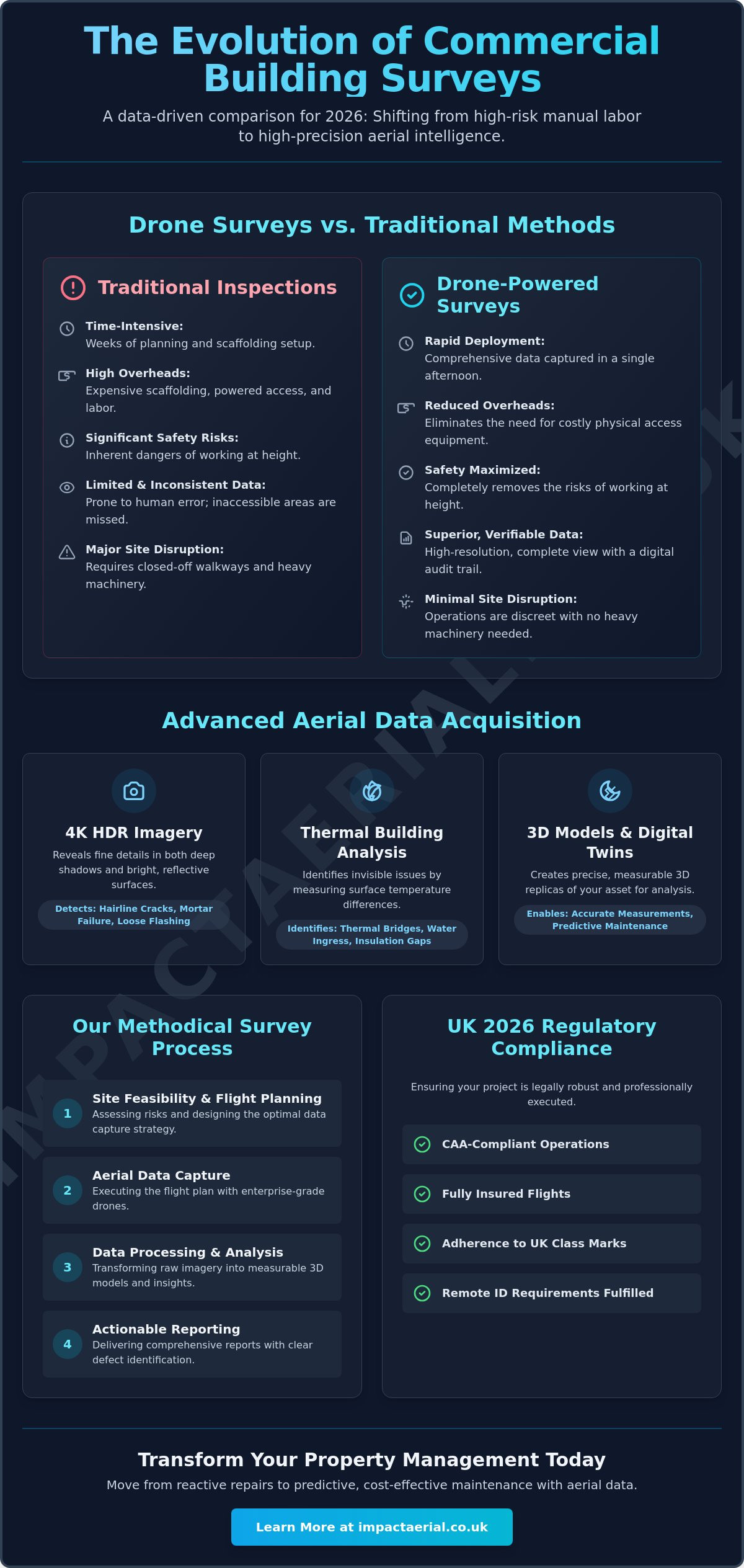
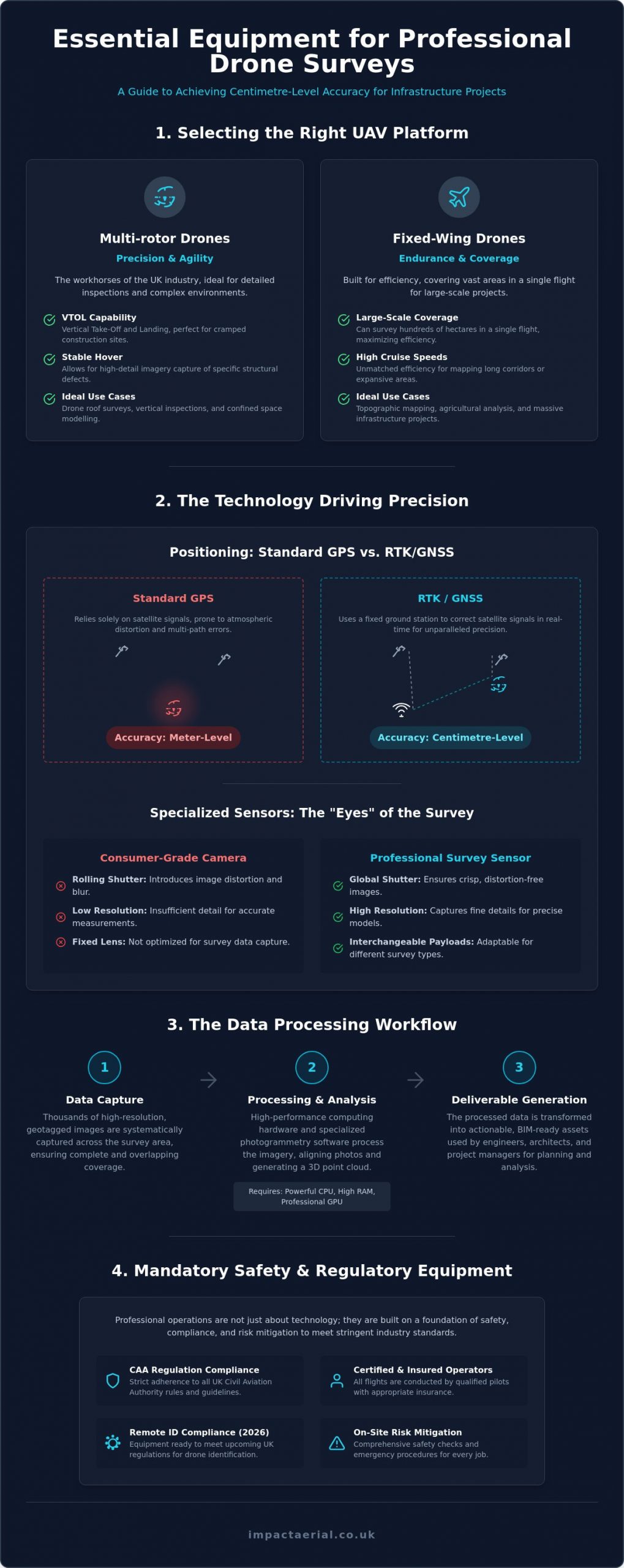
Multi-rotor aircraft are the workhorses of the UK drone industry. Their ability to hover with absolute stability makes them ideal for drone roof surveys and detailed inspections of confined spaces. Because they utilize Vertical Take-Off and Landing (VTOL) technology, they’re perfect for cramped UK construction sites where space is at a premium. The high-detail imagery captured during a hover allows engineers to identify specific structural defects that a moving aircraft might miss. Most UK firms utilize quadcopters like the Mavic 3 Enterprise for its portability or the Matrice 350 RTK for its ability to carry multiple heavy sensors simultaneously.
Fixed-Wing Drones for Large-Scale Land Mapping
While multi-rotors excel at detail, fixed-wing drones are built for endurance. These platforms can cover hundreds of hectares in a single flight, making them the preferred choice for large-scale uav land surveying and topographic mapping. Unlike their multi-rotor counterparts, they require more significant space for take-off and landing. Some models use a belly-land approach, while others have evolved to include VTOL rotors for vertical lift-off followed by horizontal flight. For massive infrastructure projects or expansive agricultural mapping, their efficiency and high cruise speeds are unmatched by traditional quadcopters.
Specialised Sensors: The “Eyes” of the Drone Survey
While the aircraft provides the means of transport, the sensors are the true workhorses of any aerial operation. They determine the resolution, accuracy, and technical utility of the collected data. Professional operators don’t rely on consumer-grade hardware; they use enterprise systems where payloads are often interchangeable to meet specific project requirements. When considering what equipment is used for drone surveys, the payload is often more important than the aircraft itself because it defines the quality of the final deliverable.
Sensor choice is dictated entirely by the specific output required, whether that’s a high-density 3D model, a topographic map, or a detailed heat map. These specialised tools allow us to capture data that exceeds the limitations of human vision and standard photography. If you’re unsure which technology fits your requirements, our experts can help you select the right aerial technology for your specific site needs.
High-Resolution RGB and Photogrammetry Sensors
Technical surveys require more than just a 4K video feed. High-resolution RGB sensors, typically featuring 1-inch CMOS sensors or larger, are the standard for professional photogrammetry. A critical distinction in identifying what equipment is used for drone surveys is the presence of a mechanical or global shutter. In consumer drones, “rolling shutters” capture images line-by-line, which causes significant geometric distortion when the drone moves at high speeds. Mechanical shutters eliminate this “jello effect,” ensuring every pixel is captured simultaneously. This precision is vital for creating high-density point clouds and accurate orthomosaics that engineers can trust for measurements.
Thermal Imaging and Multispectral Cameras
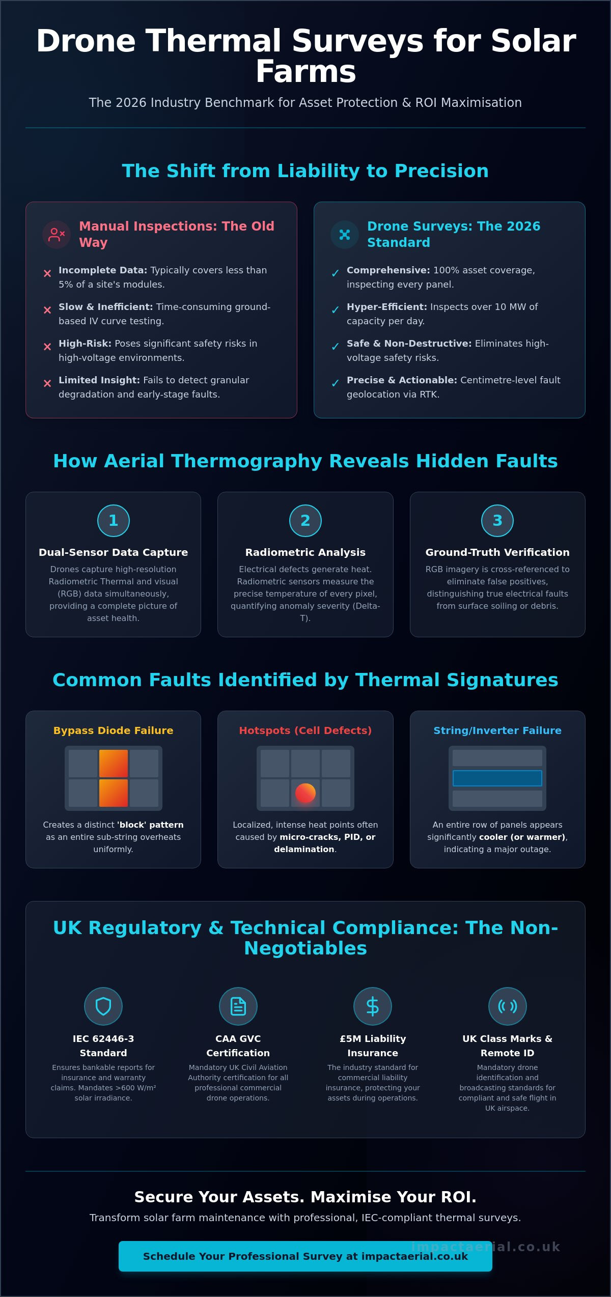
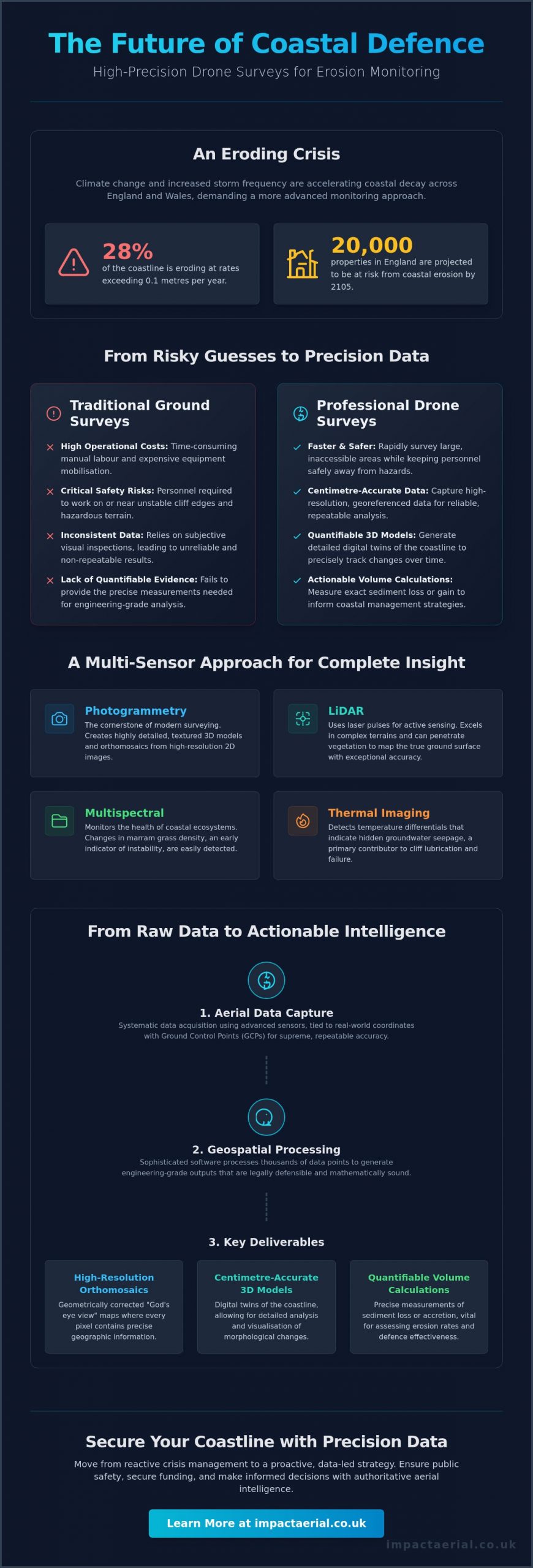
Beyond the visible spectrum, specialised sensors provide insights invisible to the naked eye. Radiometric thermal sensors are the primary tool for PV solar farm thermal surveys, where they detect minute temperature variances that indicate failing cells or electrical faults. These sensors don’t just “see” heat; they assign a specific temperature value to every pixel in the image. Similarly, multispectral sensors measure light reflection across several bands to assess plant health or environmental changes. Whether you’re identifying heat loss in a building envelope or monitoring crop stress, the choice of sensor ensures the data is both scientific and actionable.
Ensuring Survey Accuracy: GNSS and Ground Control Equipment
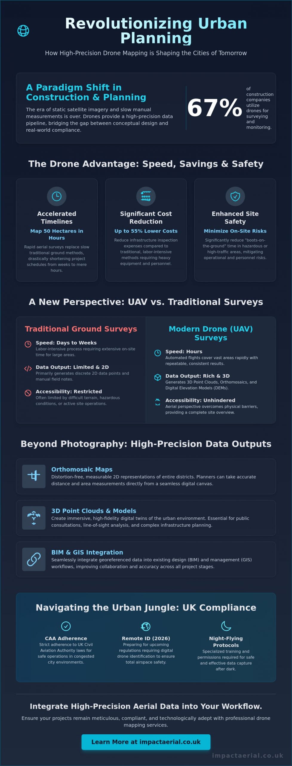
Accuracy isn’t an optional extra in the professional survey industry; it’s the core requirement that separates a visual inspection from a technical-grade deliverable. Standard Global Positioning System (GPS) technology, the kind found in consumer smartphones and entry-level drones, typically has a horizontal margin of error between 3 and 5 metres. For a construction site or a topographic map, this level of discrepancy is unacceptable and could lead to catastrophic errors in volume calculations or boundary placements. When clients ask what equipment is used for drone surveys to ensure reliability, the answer lies in the Global Navigation Satellite System (GNSS) correction hardware.
Professional surveys rely on a meticulous combination of high-frequency onboard receivers and external ground-based reference points. This ecosystem allows operators to achieve centimetre-level precision, ensuring the data is verifiable and meets RICS or specific construction industry standards. You aren’t just capturing pictures; you’re recording precise spatial data points that must align perfectly with existing site plans and legal boundaries. This level of precision is what provides the psychological comfort and tangible business benefits our clients expect.
RTK and PPK Systems for Real-Time Precision
Real-Time Kinematic (RTK) systems represent a significant leap in aerial surveying efficiency. An RTK-enabled drone maintains a constant data link with a local base station or a network of reference stations to correct satellite signal errors in real-time. This is particularly effective for projects requiring immediate data validation on-site. Alternatively, Post-Processed Kinematic (PPK) technology records raw satellite data during the flight, which is then corrected against base station data after the drone lands. PPK is often the preferred choice in environments with challenging terrain or poor signal connectivity where a constant radio link is difficult to maintain. Both technologies are essential components when considering what equipment is used for drone surveys because they drastically reduce the need for extensive manual site marking.
Ground Control Points (GCPs) and AeroPoints
Despite the advancements in onboard correction, physical Ground Control Points (GCPs) remain a staple for absolute accuracy. These are high-contrast markers placed at surveyed coordinates across the project area, serving as “anchors” that tie the digital model to a specific coordinate system like the Ordnance Survey National Grid. Modern “Smart” GCPs, such as AeroPoints, have simplified this workflow. These devices integrate their own GNSS receivers to record their precise location autonomously. Using smart markers provides a redundant, verifiable check against the drone’s data, ensuring the final output is legally and technically robust for high-stakes engineering projects.
Data Processing Hardware and Software Solutions
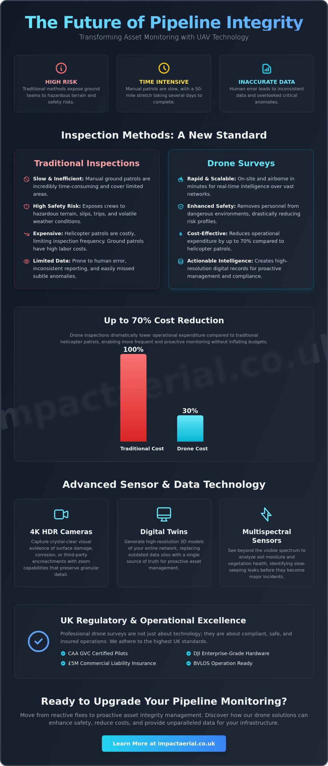
The survey mission doesn’t end when the aircraft returns to its landing pad; in many ways, the most critical work is just beginning. Raw data is merely a collection of thousands of individual files that require structured transformation to become useful. When project managers ask what equipment is used for drone surveys, they must look beyond the flying hardware to the sophisticated computing environment on the ground. High-performance workstations equipped with enterprise-grade Graphics Processing Units (GPUs) are essential for stitching these vast 4K HDR datasets into a single, cohesive output. This local processing power ensures data security while handling the massive throughput required for high-tier quality.
Modern surveying requires that all aerial data is Building Information Modeling (BIM)-ready and compatible with existing Enterprise Resource Planning (ERP) systems. This integration allows stakeholders to move from a visual perspective to a data-centric decision-making process. If you need professional-grade data that integrates seamlessly with your existing workflow, book a consultation with our technical team to discuss your project requirements.
Photogrammetry and LiDAR Processing Software
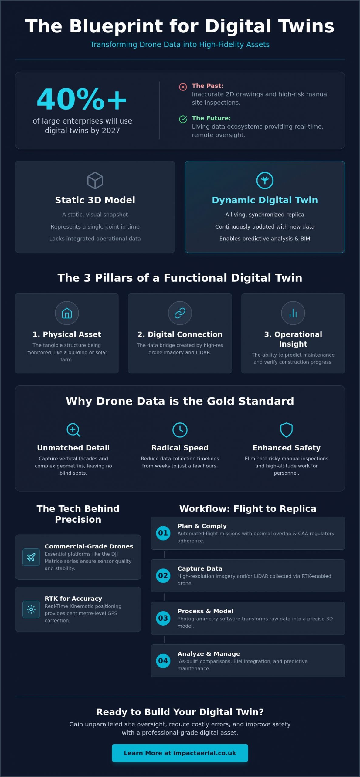
Industry-standard software like Pix4D, DJI Terra, or DroneDeploy transforms 2D images into immersive 3D models and topographical maps. These platforms are the backbone of drone data collection surveys, enabling the generation of high-density point clouds that facilitate precise measurements. For sites with significant overgrowth, LiDAR processing software is used to filter active laser pulse data, allowing us to see through canopy layers to the true ground surface. This level of technical processing ensures that the final digital twin is a meticulous and faithful representation of reality.
Post-Production and Virtual Tour Creation Gear
Beyond technical mapping, professional virtual tour creation requires specialized editing gear and 360-degree stitching software. Impact Aerial utilizes professional post-production suites to refine imagery and add interactive data layers that provide clarity to stakeholders. This process involves high-end workstations capable of rendering complex interactive environments without losing resolution. This meticulous approach to data handling ensures that your project data is not just accurate, but also actionable and easy to navigate for all team members.
The Critical Role of Safety and Regulatory Equipment
Professional drone surveys in the UK operate under the strict oversight of the Civil Aviation Authority (CAA). While high-resolution sensors and RTK systems provide the data, a comprehensive suite of safety and site management tools ensures that every mission is conducted legally and without risk to persons or property. When assessing what equipment is used for drone surveys, the conversation must include the hardware that keeps the operation within its defined safety envelope. This meticulous approach to risk mitigation is what allows us to operate on active construction sites and near critical infrastructure with absolute confidence.
The specific hardware deployed on a site is often dictated by the pilot’s operational authorizations. For instance, a CAA GVC certification enables pilots to fly in more complex environments, provided they use aircraft with the appropriate safety redundancies and site control gear. These regulations ensure that the technology is matched by professional competency and rigorous operational standards, providing clients with the reassurance that their project is in expert hands.
Essential Safety Gear for CAA-Compliant Operations
Securing a flight area requires more than just a skilled pilot; it requires a suite of specialized ground equipment. Professional operators use digital anemometers to measure real-time wind speeds, ensuring conditions remain within the aircraft’s manufacturer-specified limits before and during flight. On the ground, fire-resistant LiPo battery bags and specialized transport cases are mandatory for the safe storage and handling of high-capacity power cells. To manage the site effectively, we utilize high-visibility clothing, clear site signage, and dedicated landing pads. These tools create a visible and secure operational zone, preventing unauthorized access and ensuring a controlled environment for every take-off and landing.
Enterprise vs. Consumer Hardware: Why It Matters
The technical gap between retail drones and enterprise survey systems is most apparent in their safety architecture. Professional-grade aircraft feature omnidirectional obstacle avoidance sensors that detect hazards in all directions, providing a critical layer of protection in complex urban or industrial environments. Many enterprise models also incorporate dual-battery systems. If one cell fails mid-flight, the secondary battery provides enough power for a safe, controlled descent rather than a catastrophic failure. Additionally, these systems use encrypted data transmission to ensure that sensitive site information remains secure and private. Understanding what equipment is used for drone surveys at this level helps clients recognize the value of choosing a specialist provider that prioritizes operational integrity and data security.
Elevate Your Project Precision with Professional Aerial Data
Professional drone surveying is a sophisticated ecosystem where aircraft, sensors, and ground control hardware must work in perfect unison. By moving beyond consumer-grade tools, you ensure that every data point is accurate, compliant, and ready for immediate integration into your BIM or CAD workflows. Understanding what equipment is used for drone surveys is a critical first step for any project manager who values precision and strict adherence to UK aviation standards.
At Impact Aerial, we provide the technical expertise and high-end hardware required to deliver centimetre-level accuracy. Our operations are led by CAA GVC Certified Pilots using DJI Enterprise Grade Equipment to ensure the highest tier of data quality. We further prioritize your site security with £5m Commercial Liability Insurance, offering the reassurance that your project is in safe, expert hands.
Get a Professional Drone Survey Quote from Impact Aerial
We look forward to helping you transform your site perspective with industry-leading aerial technology and meticulous data processing.
Frequently Asked Questions
Do I need different equipment for a roof survey versus a land survey?
Yes, the choice of aircraft typically shifts between multi-rotor drones for roof inspections and fixed-wing platforms for land surveys. Roof surveys require the hovering stability of a quadcopter to capture high-detail imagery of structural defects in confined spaces. Conversely, large-scale land surveys often utilize fixed-wing drones because they can cover hundreds of hectares in a single flight with greater efficiency.
What is the difference between a standard 4K drone and a survey drone?
A survey drone is a high-precision UAV designed for repeatable data collection, whereas a standard 4K drone is primarily built for visual aesthetics. Survey-grade hardware includes mechanical shutters to prevent image distortion and integrated RTK receivers for centimetre-level positioning. These technical features ensure that the resulting data is geometrically accurate and robust enough for engineering and construction applications.
How does RTK equipment improve the accuracy of a drone survey?
RTK equipment provides live corrections to satellite signals by communicating with a local base station or a network of reference stations. This process reduces the horizontal margin of error from several metres down to just 1 to 3 centimetres. It’s a fundamental part of what equipment is used for drone surveys to ensure digital models align perfectly with real-world site coordinates and legal boundaries.
Is specialised software required to view the results of a drone survey?
You don’t necessarily need specialized software to view final PDF reports or orthomosaic images, but professional GIS or CAD software is required to manipulate 3D models and point clouds. Most providers deliver data in industry-standard formats like .LAS, .OBJ, or GeoTIFF. These files are designed for seamless integration into BIM (Building Information Modeling) environments and common architectural or engineering design tools.
What safety equipment should a professional drone pilot have on-site?
A professional pilot must deploy site management tools including high-visibility clothing, landing pads, and “Drone Operations” signage to secure the take-off area. Technical safety gear includes anemometers for real-time wind speed monitoring and fire-resistant bags for LiPo battery storage. These items are mandatory for maintaining a CAA-compliant operational environment and mitigating risks to site personnel during every mission.
Can any drone be used for thermal surveys on solar farms?
No, thermal surveys require radiometric sensors that assign a specific temperature value to every pixel in the image. Standard thermal cameras might provide a visual heat map, but they lack the scientific precision needed to identify specific failing cells or electrical faults. Professional solar farm surveys utilize enterprise platforms capable of carrying high-resolution radiometric payloads to ensure the data is scientifically actionable.
Why is a mechanical shutter important for drone surveying equipment?
A mechanical shutter is vital because it captures the entire image simultaneously, eliminating the geometric distortion caused by moving aircraft. When evaluating what equipment is used for drone surveys, a global or mechanical shutter is a non-negotiable requirement for high-speed mapping. Without it, the resulting 3D models will contain significant measurement errors that compromise the integrity of the entire survey.
What equipment is used to process drone data into a 3D model?
Processing requires high-performance computing workstations equipped with powerful GPUs and specialized photogrammetry software like Pix4D or DJI Terra. This hardware-software combination stitches thousands of individual 2D images together into a cohesive 3D point cloud or digital twin. The process is computationally intensive, requiring significant RAM and processing speed to handle large 4K HDR datasets effectively after the flight is completed.