
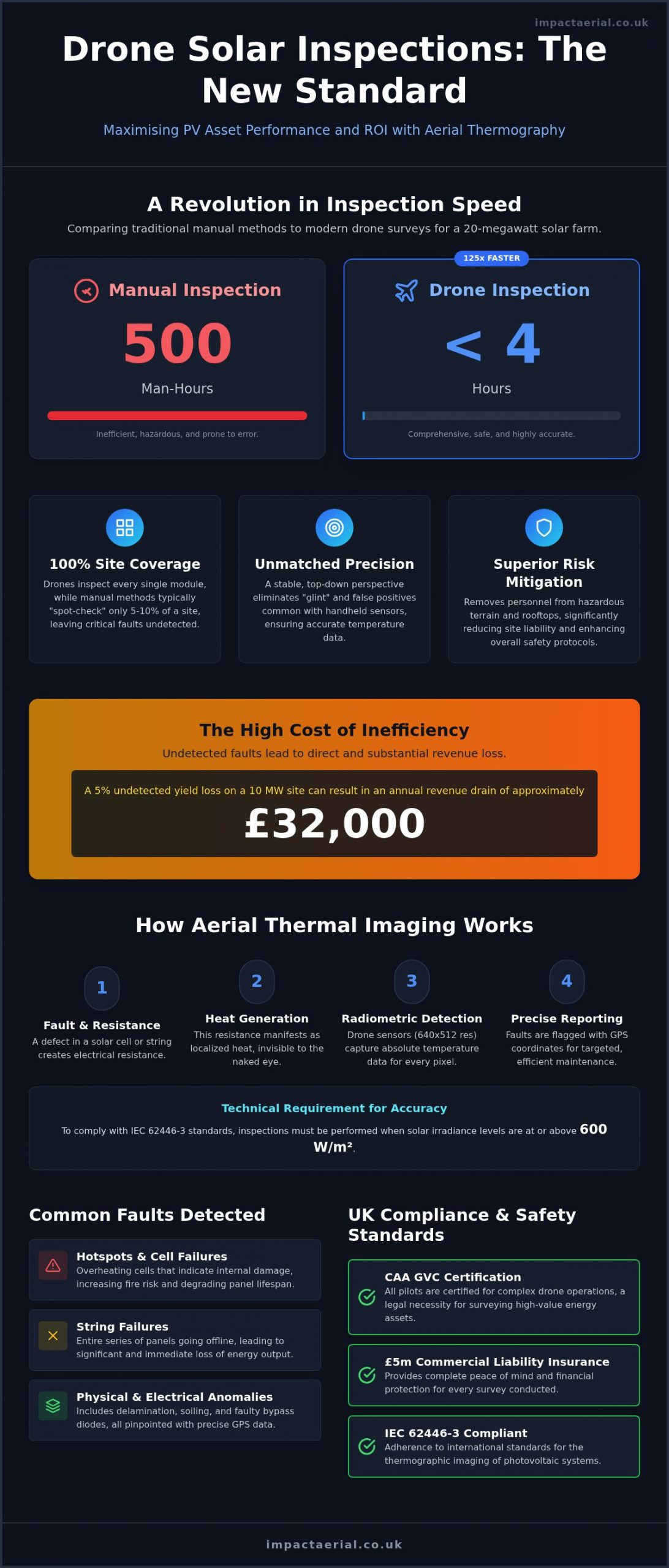
Did you know a manual inspection of a 20-megawatt solar farm can take up to 500 hours, whereas a professional drone solar panel inspection completes the same task in less than four hours? For asset managers across the UK, the struggle with slow, hazardous manual surveys and the resulting lost revenue from undetected string failures is a constant pressure. You likely understand that even a 5% undetected yield loss on a 10 MW site can lead to an annual revenue drain of approximately £32,000. It’s frustrating to know your PV assets aren’t performing at peak capacity because traditional methods are simply too costly or inefficient to deploy regularly.
This guide demonstrates how professional thermographic surveys identify faults 10x faster than manual methods while significantly improving the ROI of your PV assets. We’ll examine the technical precision of specialized drone hardware, the necessity of CAA GVC certified pilots, and how actionable reports with precise GPS coordinates can streamline your maintenance roadmap. From meeting the 2026 UK Remote ID regulations to providing comprehensive documentation for insurance claims, you’ll learn why drone technology is now the industry standard for solar site health and long-term reliability.
Key Takeaways
- Understand why a professional drone solar panel inspection is the only viable method for 5MW+ farms, using thermal and RGB sensors to detect anomalies at a scale manual methods cannot reach.
- Learn the science of radiometric thermal imaging and how it provides absolute temperature data for every pixel to pinpoint electrical resistance accurately.
- Discover how to detect critical faults like hotspots and string failures before they escalate into fire risks or significant output losses.
- Verify the essential UK compliance standards, including the necessity of CAA GVC certification and £5m commercial liability insurance for high-value energy assets.
- Explore how technical consultancy and nationwide response times from a central UK hub ensure meticulous risk mitigation for your PV portfolio.
Why Drone Solar Panel Inspections are Replacing Manual O&M
The transition from ground-based maintenance to aerial intelligence is a fundamental shift in how UK solar assets are managed. A professional drone solar panel inspection uses a combination of high-resolution RGB sensors and radiometric thermal cameras to detect anomalies within PV modules that are invisible to the naked eye. For utility-scale sites exceeding 5MW, manual inspections have become a logistical impossibility. Attempting to walk a 20-megawatt farm with a handheld sensor typically requires 500 man-hours, whereas an enterprise-grade drone completes the task in less than four hours. Drone thermography serves as a non-invasive diagnostic method that maintains full compliance with IEC 62446-3 standards for infrared imaging of photovoltaic systems.
Risk mitigation is a primary driver for this technological adoption. By removing the need for personnel to navigate uneven, hazardous terrain or work at height on commercial rooftops, asset managers significantly reduce their site liability. Our pilots operate with £5m commercial liability insurance, ensuring that every survey is conducted under the highest safety protocols. This methodical approach provides a level of reassurance that manual teams simply cannot match, especially when operating in the unpredictable UK climate.
To better understand the technical advantages of this process, watch this helpful video:
The Limitations of Traditional Handheld Inspections
Relying on technicians with handheld thermal cameras introduces substantial human error. For accurate data, the sensor must maintain a consistent viewing angle relative to the panel surface to avoid “glint” or false positives from reflections. This is nearly impossible to achieve consistently while walking through rows of panels. The Science of Thermal Drone Surveys demonstrates that a stable, top-down perspective is essential for identifying subtle heat signatures that indicate electrical resistance. Furthermore, manual IV curve tracing across thousands of individual panels is a massive time-sink. Most manual O&M providers resort to “spot-checking” just 5-10% of a site, which inevitably leaves critical string failures and hotspots undetected, leading to significant long-term revenue loss.
The Efficiency Force Multiplier: Speed vs Accuracy
By deploying high-end DJI Enterprise hardware, a single flight can capture data across 50MW of solar capacity in a single day. This isn’t just about speed; it’s about achieving 100% site coverage. Every single module is documented with precise GPS coordinates, allowing for a prioritised maintenance roadmap rather than a guessing game. This level of comprehensive data is explored further in The Complete Guide to Aerial Data Collection. When you consider that a 5% undetected yield loss on a 10MW site can drain £32,000 annually, the precision of a drone solar panel inspection pays for itself almost immediately by ensuring every fault is identified and rectified during a single site visit.
The Science of Thermal Drone Surveys: How it Works
A professional drone solar panel inspection relies on the physics of infrared (IR) thermography to visualise what the human eye cannot. When a solar cell or string develops a fault, it creates electrical resistance, which manifests as localised heat. We utilise radiometric thermal sensors, typically with a resolution of 640×512, to capture absolute temperature data for every single pixel in an image. This allows our technical consultants to calculate the “Delta-T” (the temperature difference) between a suspected fault and a healthy neighbouring cell, ensuring that only genuine defects are flagged for repair.
The accuracy of these surveys depends heavily on specific environmental conditions. To comply with international IEC standards, we perform inspections only when solar irradiance levels reach at least 600W/m². Without this level of sunlight, the thermal contrast is insufficient to reliably identify internal module failures. We simultaneously capture high-resolution RGB (visual) data to cross-reference every thermal anomaly. This is a critical step; it helps us determine if a hotspot is caused by an internal electrical failure or simply by external factors like bird droppings, dust, or “shading” from nearby vegetation.
DJI Enterprise Hardware: The Industry Standard
Impact Aerial operates using the DJI Matrice 300 and 350 RTK platforms, which are the benchmarks for stability and sensor precision in the energy sector. These aircraft utilise Real-Time Kinematic (RTK) positioning to achieve centimetre-level geolocation for every image captured. When our pilots follow the UK compliance and safety standards, they aren’t just flying safely; they’re ensuring that every fault identified is tagged with precise GPS coordinates. This meticulous data collection allows us to produce actionable PDF reports and GIS-ready files that your maintenance teams can use to walk directly to a faulty module without wasting time searching.
Photogrammetry vs Spot Inspections
Modern asset management has moved beyond simple spot checks. We use photogrammetry to build a “digital twin” of your entire solar farm. By stitching thousands of individual images together, we create an orthomosaic map, which is a high-resolution, measurable top-down view of the entire asset. This map serves as a baseline for year-on-year degradation tracking, allowing you to monitor how specific strings or sections of the farm are performing over time. For site managers looking to implement these technical standards, our PV Solar Farm Thermal Surveys provide the granular data needed to integrate drone findings directly into existing Asset Management software.
Common Faults Detected by Drone Solar Inspections
A technical drone solar panel inspection provides a level of diagnostic detail that ground-based teams cannot replicate. By identifying specific thermal signatures, we can pinpoint failures before they lead to catastrophic equipment damage or prolonged downtime. For instance, Hotspots are localised areas of high resistance within a cell. If left unaddressed, these can escalate into fire risks or cause the protective glass to shatter. We also frequently detect String Failures, where entire rows of modules are disconnected. These are often caused by inverter issues or cabling faults, and they represent the most immediate threat to your site’s energy output.
Beyond simple heat spots, our specialised thermal post-production expertise allows us to identify complex electrical issues that traditional surveys often overlook:
- Bypass Diode Issues: These appear as distinct rectangular heat signatures across a module, indicating that a section of the panel has been bypassed to protect it from further damage.
- Potential Induced Degradation (PID): This is identified by characteristic heat patterns usually found at the end of strings near the negative pole, often caused by a voltage potential between the cells and the frame.
- Physical Damage and Soiling: High-resolution RGB data allows us to distinguish between internal faults and external issues like micro-cracks, delamination, or heavy soiling from bird droppings and dust.
Categorising Anomalies by Severity
Data is only valuable if it’s actionable. We don’t just provide a list of faults; we categorise every anomaly to streamline your maintenance roadmap. Critical Faults are those presenting immediate safety risks or total string outages that require urgent intervention. Major Faults indicate significant yield loss where the cost of repair is justified by the immediate boost in revenue. Finally, Minor Faults are documented for monitoring, allowing your O&M teams to address them during the next scheduled site visit, ensuring your labour costs are managed efficiently.
The ROI of Early Detection
The “Cost of Inaction” is a tangible metric for asset managers. As previously noted, a 10MW site can lose over £32,000 annually from minor undetected failures. A drone solar panel inspection provides the indisputable evidence required for Warranty Claims against manufacturers, often paying for the survey itself through successful module replacements. Proactive risk management also serves as a powerful tool when negotiating with underwriters. By demonstrating meticulous site monitoring and fault rectification, you can often mitigate rising insurance premiums and protect the long-term valuation of your PV portfolio.
UK Compliance and Safety Standards for Drone Surveys
Operating a drone solar panel inspection on a utility-scale site requires more than just technical skill; it demands strict adherence to the UK’s evolving aviation legal framework. For any commercial operation, especially those involving high-value energy infrastructure, the pilot must hold a General Visual Line of Sight Certificate (GVC) issued by the Civil Aviation Authority (CAA). This certification isn’t merely a formality. It’s a legal requirement that proves the operator has the competency to manage complex flight paths and emergency procedures in a commercial environment. We also maintain £5m commercial liability insurance as a baseline standard. This level of coverage provides essential reassurance to asset managers that their property and professional indemnity are protected against unforeseen incidents.
Safety management on-site begins long before the drone takes off. We develop site-specific Risk Assessments and Method Statements (RAMS) for every project, accounting for local hazards such as public footpaths, nearby roads, or livestock. Privacy and data protection are equally critical. When surveying near residential areas or public rights of way, we ensure our flight plans and data capture protocols comply with UK GDPR and surveillance laws. This meticulous approach to compliance ensures that your survey data is not only technically accurate but also legally sound for use in official documentation or insurance claims.
Navigating CAA Regulations in 2026
The regulatory landscape for drones in the UK changed significantly as of January 1, 2026. It’s now mandatory for commercial operators to ensure their aircraft have the Remote ID function active, particularly when flying UK1, UK2, or UK3 class drones. Our pilots handle all aspects of operational authorisation and pre-flight planning, which includes checking for temporary flight restrictions and issuing NOTAMs (Notice to Airmen) where necessary. Understanding these nuances is vital for site managers who need to ensure their contractors aren’t operating illegally. For a deeper dive into these requirements, see our UK Drone License: A Simple Guide to CAA Rules in 2026.
Meticulous Planning for Solar Farm Safety
Solar farms present unique technical challenges, specifically regarding electromagnetic interference (EMI) from high-voltage inverters and substations. An uncertified hobbyist pilot might not understand how EMI can disrupt a drone’s internal compass or GPS link, leading to a “flyaway” risk. A GVC certified pilot is trained to maintain safe separation distances from infrastructure while still capturing the high-resolution data required for an effective drone solar panel inspection. Hiring a vetted specialist ensures that you’re not just getting a thermal map, but a safe, compliant operation that protects your professional reputation. If you’re ready to secure your site’s performance with a compliant survey, contact our technical consultants today to discuss your PV portfolio requirements.
Why Partner with Impact Aerial for Your Solar Inspections?
Choosing a partner for your PV asset maintenance requires a balance of technical proficiency and operational reliability. Impact Aerial operates as a technical consultant rather than just a drone operator, bringing years of commercial experience to every drone solar panel inspection we conduct. Our central hub in Birmingham, West Midlands, allows us to provide nationwide UK coverage with rapid response times. This strategic location ensures that we can deploy our teams to any solar farm across the country, providing the reassurance that your assets are being monitored by vetted specialists who understand the high-stakes nature of the energy sector.
We provide a comprehensive end-to-end service that manages the entire lifecycle of a survey. This begins with meticulous pre-flight planning and CAA compliance, moves through precision data capture using enterprise-grade hardware, and culminates in expert post-production analysis. Our commitment to reliability means we don’t just hand over raw data; we provide a prioritised maintenance roadmap that simplifies your decision-making process. By centralising these services, we eliminate the friction often found when working with multiple contractors, ensuring a seamless flow from the initial site visit to the final fault report.
Our Technical Expertise and High-End Output
Precision is the cornerstone of our operations. We utilise commercial-grade DJI Enterprise drones, such as the M300 and M350 RTK, equipped with high-resolution thermal sensors. These platforms offer superior thermal resolution, allowing us to identify micro-anomalies that lower-tier equipment would miss. Every fault we detect is tagged with centimetre-level GPS precision, ensuring your ground crews can navigate directly to the affected module without delay. This meticulous approach to data quality is a hallmark of our broader commitment to excellence, which you can explore in A Complete Guide to Professional Drone Services in the UK.
Get a Professional PV Thermal Survey Quote
Our consultation process is designed to be straightforward and informative. We start by understanding your specific site capacity and reporting requirements, whether you’re managing a single 5MW site or a nationwide PV portfolio. You can expect minimal site disruption during our surveys; we often operate while the farm remains fully operational, reducing downtime and protecting your generation revenue. Our final reports are designed for maximum data density, providing the comprehensive documentation needed for insurance or warranty claims. To receive a tailored proposal for your next drone solar panel inspection, contact our Birmingham office today. We’ll provide a clear, technical breakdown of how our aerial surveys can maximise the ROI of your solar assets.
Securing the Future of Your PV Portfolio
Professional aerial thermography has transformed from a luxury into a technical necessity for UK asset managers. By shifting from manual spot-checks to 100% site coverage, you gain a prioritised maintenance roadmap that addresses critical faults before they impact your bottom line. We’ve seen how high-end DJI Enterprise hardware and specialised thermal post-production expertise provide the indisputable data needed for successful warranty and insurance claims. This methodical approach ensures your assets remain compliant, safe, and high-performing.
A professional drone solar panel inspection is a strategic investment in your site’s longevity. Impact Aerial provides nationwide UK coverage from our central Birmingham hub, supported by CAA GVC certified pilots and £5m commercial liability insurance. We handle the technical complexity and regulatory compliance so you can focus on maximising generation revenue. It’s time to take the guesswork out of your O&M strategy.
Request a Professional Drone Solar Inspection Quote from Impact Aerial
We look forward to helping you protect the performance and reliability of your solar energy assets.
Frequently Asked Questions
How accurate is a drone solar panel inspection?
Professional aerial surveys are exceptionally accurate when using enterprise-grade radiometric sensors with 640×512 resolution. This hardware allows technical consultants to measure the precise temperature of every pixel, identifying “Delta-T” variations that indicate internal module failures. When combined with RTK (Real-Time Kinematic) positioning, every identified fault is geolocated to within a few centimetres, ensuring ground crews can find the exact panel without delay.
What is the best time of year for a PV thermal survey in the UK?
The ideal window for UK solar surveys is between April and September. To meet international IEC standards, the sun must provide at least 600W/m² of irradiance to create enough thermal contrast for the sensors to work effectively. We monitor weather data closely to ensure flights take place during peak solar windows, typically between 10:00 and 14:00, when the sun is at its highest angle.
Do drones need special permission to fly over solar farms?
Yes, all commercial drone operations require specific qualifications and permissions. Pilots must hold a General Visual Line of Sight Certificate (GVC) from the Civil Aviation Authority (CAA) to operate in the “Specific Category.” Beyond legal certifications, we coordinate directly with site managers to establish safety protocols and check for any local airspace restrictions or temporary flight hazards before deployment.
Can drones detect micro-cracks in solar panels?
Drones detect the thermal symptoms of micro-cracks rather than the physical cracks themselves. When a cell is compromised by a micro-crack, it creates electrical resistance that shows up as a hotspot on a thermal map. While drones don’t replace EL (Electroluminescence) testing for factory-level crack analysis, they are the most efficient way to find the resulting performance issues across thousands of modules.
How long does it take to get the final inspection report?
You can typically expect your comprehensive fault report within 5 to 10 business days. This timeframe is necessary for our specialised thermal post-production team to analyse thousands of images and cross-reference them with visual data. We produce high-resolution PDF reports and GIS-ready files that integrate directly into your existing asset management software for immediate action.
Is drone solar inspection more expensive than manual methods?
While the daily rate for a professional drone team is higher than a manual ground crew, the total project cost is significantly lower. A drone solar panel inspection is 10x faster than manual methods, meaning you pay for far fewer man-hours on site. The increased data accuracy also ensures a higher ROI by catching faults that manual “spot-checking” would likely miss.
What happens if the weather is cloudy on the survey day?
We reschedule the survey if the cloud cover prevents irradiance from reaching the mandatory 600W/m² threshold. Valid thermal data requires consistent solar loading to “heat up” the panels enough for internal faults to become visible. Our team manages the scheduling and weather monitoring as part of our end-to-end service, ensuring we only fly when the data quality will be 100% reliable.
Are Impact Aerial pilots fully insured for commercial work?
Yes, all our pilots are covered by £5m commercial liability insurance as a standard requirement. This level of coverage is essential for working on high-value energy infrastructure and provides the necessary reassurance for site owners and asset managers. We don’t just follow the law; we maintain the highest industry standards for risk mitigation and professional indemnity across all UK projects.
 2 Norton Drive, Wythall, Birmingham, B47 6HH Company registration number: 11138586. VAT Number: 366 9068 55


