
Hiring a Commercial Drone Operator in the UK for Aerial Services

A commercial drone pilot does more than take aerial images: they plan and carry out flights for specific business tasks. When hiring a commercial drone operator in the UK, look for someone with a flyer ID, an operator ID and insurance; commercial operators must have third-party liability insurance when flying for work, whatever the drone’s weight. Drones weighing 20kg or more must always have third-party insurance, regardless of use.

It’s sensible to look beyond the footage and understand how a pilot will manage the flight, meet your brief and deliver usable results. This guide explains what commercial drone operators do, how a project typically runs and what can affect its cost. It also covers how to check a pilot’s identity and CAA qualifications, helping you choose the right expertise for your aerial work.

Key Takeaways

  • Match the aerial service to the job: photography, surveys, inspections and mapping each produce different kinds of information.
  • Narrow your search by location, project requirements and the pilot’s relevant experience to find a suitable operator.
  • Learn what to review when checking a pilot’s identity, CAA credentials and insurance before a flight.
  • See how aerial filming, property surveys, solar farm thermal surveys and construction monitoring can support different project goals.

What does a commercial drone pilot do?

A commercial drone pilot plans and conducts flights for business purposes, capturing or collecting the information required. For a property survey, for example, the pilot needs to know which elevations or roof areas must be recorded. Hiring a commercial drone operator in the UK means assessing both the flight work and the preparation behind it.

UK commercial drone pilots normally need a flyer ID, an operator ID and insurance. Commercial operators must have third-party liability insurance when flying for work, regardless of whether the drone weighs less than 20kg. Drones weighing 20kg or more must always have third-party insurance, regardless of use. Employers hiring drone pilots commonly expect at least 40 hours of recorded flight experience.

A professional drone operator also prepares operational documents. An operations manual can help set out how a commercial drone pilot plans to use the drone. Pilots should make sure their training and permissions are appropriate for the work they plan to do. For work near people or buildings, ask the operator to explain which authorisation applies to the proposed flight. An ID alone does not show whether a specific operation is covered.

When choosing between a freelance drone pilot and a drone company, consider the project’s scope and how you want to work. A freelancer offers a direct relationship with the pilot; a company provides an organisation as your contracting point. Either way, compare relevant experience, documentation and planned deliverables.

Check insurance by reviewing the current certificate and policy details. Confirm that the insured name matches the operator you’re contracting, the policy is in force for the flight date, and its wording covers commercial drone work. Public liability insurance is the commonly used term; check that the policy includes third-party liability cover for the planned activity.

The fee depends on the project and is provided after a quote request. Cost factors include the site, flight complexity, equipment, deliverables and post-production. A straightforward image capture and a detailed survey require different planning and outputs, so compare quotes against the same project brief.

Aerial photography, surveys, inspections and mapping

Aerial photography creates overhead and angled images for marketing, progress records or site context. Define the subject, viewpoints and intended use in the brief. For a construction update, for example, repeatable angles can help show visible changes between visits. The final image selection and editing also affect how clearly viewers can interpret the scene.

A survey or inspection documents a particular asset or condition, rather than focusing only on attractive imagery. For a commercial roof survey, the pilot can capture views of roof coverings, drainage points and visible defects. Identify priority areas before the flight, then agree how images will be labelled and delivered. Close aerial views can support a visual review, but they don’t guarantee that concealed faults will be detected.

Drone mapping combines overlapping aerial images to create mapped or modelled site information. The brief should specify the area, required output and intended use. A map of a land or construction site, for instance, needs consistent coverage and a clearly defined boundary. Ask what files will be delivered and whether they fit your team’s mapping or design workflow.

  • Photography: define the purpose, key subjects and preferred viewpoints.
  • Inspections: list the asset areas and visible conditions you need recorded.
  • Surveys: specify the site boundary and required reporting format.
  • Mapping: explain how the mapped output will inform a project decision.

These distinctions help you match the flight plan to the result you need. For a roof or building project, commercial property survey work can provide a focused route from site requirements to aerial records. Describe the asset and intended use in your brief, so the operator can shape the capture around the task.

Hiring a Commercial Drone Operator in the UK for Aerial Services

Searching for UK drone pilots by area, service or skill

Start with the project location and the result you need. Look for pilots who work in the area and specialise in the task, such as filming, property inspection or construction monitoring. A local operator may reduce travel requirements, while relevant specialist experience can matter more than proximity for a technically demanding brief.

Compare candidates using the same project details: site address, purpose, required images or data, preferred dates and intended use. Then assess their experience against the task itself. A pilot experienced in promotional filming may not have the same skills as someone producing inspection records or monitoring a construction site.

For specialist filming and photography, describe the subject, desired viewpoints and final format. A property campaign may need polished exterior footage, while an event brief could prioritise movement and changing crowd scenes. Aerial work can create striking perspectives, but the visual approach should serve the brief rather than distract from it.

Construction projects benefit from pilots who understand repeatable site coverage and progress records. A useful brief identifies areas of interest, access arrangements and how the project team will use the images. Maritime work calls for different experience, such as capturing vessels or coastal infrastructure; specify the site and operational setting when searching.

The price of a commercial drone project depends on the work and is provided after a quote request. Key factors include location, flight complexity, equipment, deliverables, editing and travel requirements. A short filming brief and a multi-visit construction record involve different planning and post-production.

Weather, location and flight restrictions affect scheduling, safe flying conditions, access and where the aircraft can operate. Share the exact site and preferred dates early, then plan around suitable conditions and any applicable airspace constraints. An urban roof inspection, for example, may need different site coordination from filming in an open rural location.

Verification of pilot identity and CAA qualifications

Ask the pilot to show photo identification and match their name against the qualification documents and contract. Confirm that the person attending the site is the person whose credentials you reviewed. A company profile can help you understand stated experience, while documents provide a direct way to check identity and training.

UK drone pilot training with a Recognised Assessment Entity can take 2 to 4 days. Training covers UK air regulations, flight safety, flight planning, a theory test and practical flight skills assessment. Experienced pilots may pursue the Level 3 Certificate and Level 4 Diploma in the Remote Piloting of Unmanned Aircraft Systems.

GVC and A2 CofC are qualification names you may encounter in a pilot’s profile. Ask to see the actual certificate, note the holder’s name and check that it belongs to the person assigned to your project. Then ask the operator to explain how their qualification and operational authorisation relate to the planned flight. Operational authorisation must be renewed every 12 months.

To verify authorisation and insurance, request the relevant documents and compare the operator’s name, validity dates and covered activity with your booking. Read the authorisation’s scope in relation to your site, aircraft and proposed operation. For insurance, check the policy period and confirm its wording covers commercial drone work and third-party liability. Keep copies with your project records.

  • Identity: match the pilot’s photo ID to the certificate and booking documents.
  • Qualification: record the certificate name and holder.
  • Authorisation: review its scope and renewal date.
  • Insurance: check the named insured, policy period and relevant cover.

For a building project, these checks can sit alongside a clear survey brief. Arrange a drone property survey with the site and required information in mind, so the planned work and its documentation align.

Impact Aerial: Aerial Filming and Photography

Impact Aerial provides Aerial Filming and Photography for businesses that need professional aerial footage or stills. Its CAA GVC certified pilots use commercial-grade multirotor drones equipped with 4K HDR cameras, supporting detailed capture for property, construction and advertising projects.

For asset-focused projects, Impact Aerial offers PV Solar Farm Thermal Surveys, Drone Commercial Property Surveys and Construction Site Monitoring. These services address different requirements, from documenting a building’s exterior to recording construction progress or surveying solar farm panels. Set out the site, intended use and required deliverables in your brief to align the aerial capture with your needs.

If your project needs aerial filming, photography or a related survey service, contact Impact Aerial to discuss the work.

Turn your brief into a clear project plan

Start by defining what the aerial work needs to achieve. Before hiring a commercial drone operator in the UK, set out the site, purpose of the flight, areas to capture and how you’ll use the results. This creates a practical scope and makes it easier to compare proposals by the work included, rather than by a headline description alone.

For property or solar projects, specify the assets and information you need documented. For filming, describe the intended audience and visual style. A clear brief gives the operator a strong starting point for planning the capture and delivery around your objectives.

Impact Aerial can support projects requiring Aerial Filming and Photography, PV Solar Farm Thermal Surveys or Drone Commercial Property Surveys. Contact Impact Aerial to discuss your project and take the next step towards a well-planned aerial service.

Frequently Asked Questions

What services do UK commercial drone operators offer, such as photography, surveying and inspections?

UK commercial drone operators can provide aerial photography and filming, property inspections, surveys, mapping, construction progress records and thermal surveys. Some also create virtual tours or edit captured footage. Choose based on the outcome you need: a roof inspection may call for labelled condition images, while a marketing brief may need edited video. Define the deliverable first, then match the operator’s specialism to the task.

What information should I provide when requesting a quote from a UK drone operator?

Give the operator the site address, project purpose, areas to capture and preferred dates. Explain access arrangements, nearby obstacles or busy activity, and whether the work requires a single visit or repeat coverage. Specify the deliverables, such as still images, edited video or survey records, and how your team will use them. A marked-up site plan can clarify boundaries and priority viewpoints.

What are the steps for hiring a commercial drone operator in the UK?

Begin with a brief defining the site, task and required outputs. Shortlist operators with relevant experience, then review their identity, qualifications and insurance documents. Compare proposals against the same scope, including deliverables, scheduling and post-production. Agree the project details in writing, coordinate site access with the operator and review the completed files against your original brief.
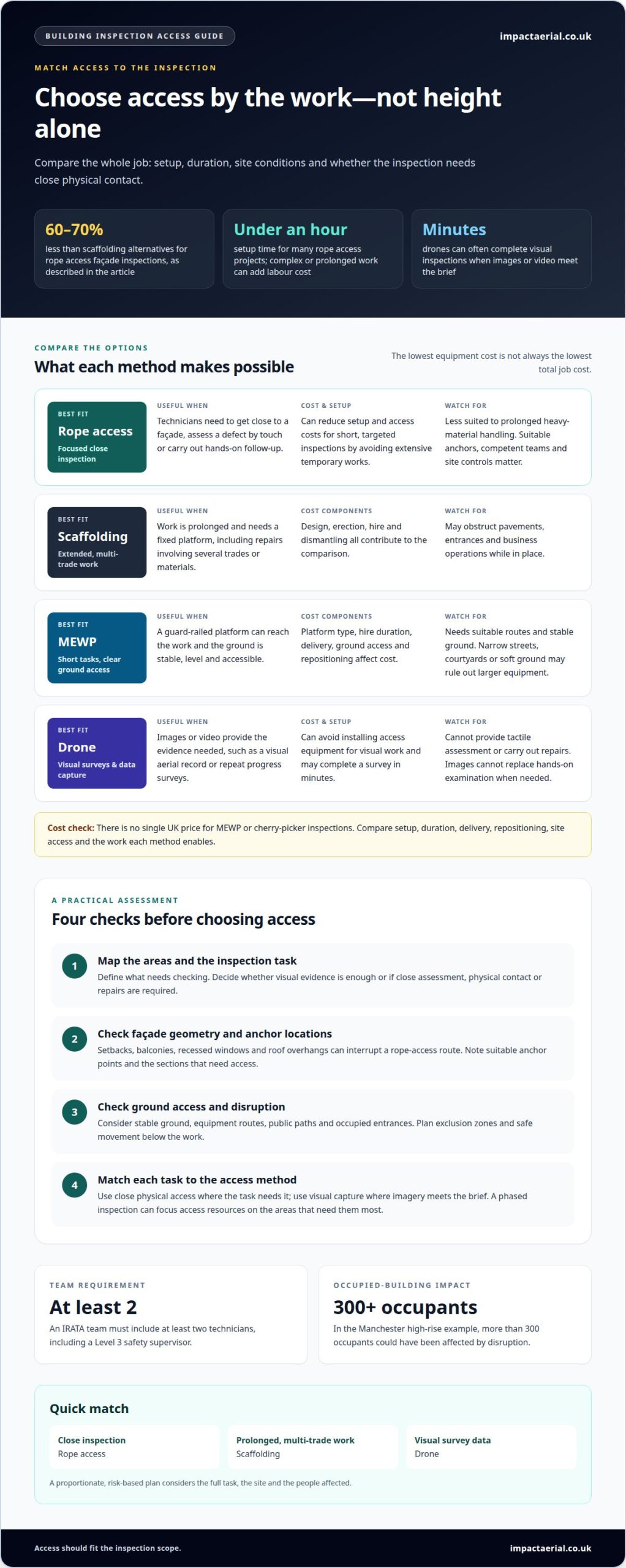
Alternatives to Rope Access Inspection Costs Compared

For short, targeted façade inspections, rope access can cost less than scaffolding because it avoids extensive temporary works. The cost of alternatives to rope access inspections depends on the task: scaffolding can suit prolonged work that needs a fixed platform, while drones can be a practical option for visual surveys without putting people at height.

The fastest way to reach a building is not always the lowest-cost option. Height, façade geometry, ground access and the level of detail required all affect the choice and the total cost.

This comparison covers rope access, scaffolding, MEWPs, drones and phased inspections. It explains when each method is useful, where its limitations matter and how to match access to the inspection, rather than paying for equipment or access the task does not require.

Key Takeaways

  • Compare access methods by the whole job, including setup, duration and the work each method makes possible.
  • Use building height, façade shape and ground access to narrow down practical options before planning an inspection.
  • Choose drones for visual survey data where suitable, and reserve physical access for tasks that need close contact or hands-on work.
  • A phased approach can help target access resources to the areas and tasks that need them most.

Is rope access really cheaper than scaffolding?

In the UK, alternatives to rope access inspections include scaffolding, mobile elevating work platforms (MEWPs), cherry pickers and drones. Some alternatives cost less for brief visual checks, but a fair comparison also considers site access, inspection scope and whether workers need physical contact with the structure.

Rope access can cost less for short, targeted inspections because it avoids extensive temporary works. Rope access façade inspections are described as typically costing 60-70% less than scaffolding alternatives. Project duration and required access affect the comparison.

Rope access can also be more cost-effective than MEWPs on taller buildings, particularly where ground access is restricted. Safety depends on suitable anchors, competent teams and site controls. An IRATA team must include at least two technicians, including a Level 3 safety supervisor.

There is no single UK price for MEWP or cherry-picker inspections. Costs depend on platform type, hire duration, delivery, ground access and repositioning. Whether an alternative to rope access costs less overall depends on the inspection scope and how long the equipment is needed.

Option Typical use Cost considerations Key limitation
Rope access Targeted inspections Can reduce setup and access costs Less suited to prolonged heavy-material handling
Scaffolding Long-duration, multi-trade work Design, erection, hire and dismantling May disrupt pavements and entrances
MEWP or cherry picker Short tasks with suitable ground access Delivery, hire and positioning Needs suitable routes and stable ground
Drone Visual surveys and data capture Can avoid installing access equipment Cannot provide hands-on inspection

Scaffolding provides a fixed platform for extended repairs; MEWPs offer a guard-railed platform but depend on suitable ground conditions. Drones capture visual data without placing inspectors at height, but cannot assess defects by touch. The Health and Safety Executive supports proportionate, risk-based planning for work at height. Choose rope access for focused close inspection, scaffolding for prolonged multi-trade work, and a MEWP where ground access is clear.

Building height, geometry and ground access

Height matters, but façade shape and access points matter too. On a tall, flat elevation, technicians may move between suitable anchor points to inspect defined sections. Setbacks, projecting balconies, recessed windows and roof overhangs can interrupt that route. A MEWP may reach a lower elevation efficiently, provided the ground is stable, level and accessible. Narrow streets, internal courtyards or soft ground can rule out large access equipment.

Ground-level disruption also affects occupied buildings. Scaffolding can obstruct entrances, pavements and business operations for the time it remains in place. In the Manchester high-rise example, more than 300 occupants could have been affected by disruption. Rope access can reduce the footprint at ground level when only selected areas need inspection, helping keep public routes and building entrances clearer. The access plan should identify exclusion zones and how people will move safely below the work.

Heritage buildings often have complex elevations and sensitive surroundings. Close visual inspection can help identify cracked masonry, deteriorating mortar, loose stone or failed sealant without placing a large temporary structure against the façade. Rope access technicians can also inspect parapets, copings, roof edges and rainwater goods. Cleaning is a separate task: inspection findings can record soiling or visible defects, but cleaning alone cannot establish whether a component is secure or needs repair.

For maintenance, match access to the work rather than the building’s height alone. A focused inspection may need close visual assessment and photographs; replacing cladding across a broad elevation may need a continuous platform for materials and several trades. A practical assessment starts by mapping the areas to inspect, noting anchor locations, checking ground access and identifying public routes or occupied entrances. Then match each task to the access method. For a visual aerial record of commercial premises, drone commercial property surveys can help document external elevations without installing ground-based access equipment.

Alternatives to Rope Access Inspection Costs Compared

Rope Access vs Drone Inspections: Which Is Right for Your Business?

For a building inspection, the choice depends on whether you need visual evidence, close physical assessment or repairs. Compare access time, equipment, team requirements and the work each method can complete.

Rope Access Inspection Costs

Rope access suits inspections that need technicians close to a façade, especially when physical contact helps assess a defect. Setup takes under an hour for many projects, but complex or prolonged work can increase labour costs. Drones can often complete visual inspections in minutes, making them more efficient when images or video meet the inspection brief. They cannot provide tactile assessment or carry out repairs.

Choose rope access for building maintenance when close inspection or hands-on follow-up is part of the task. Choose drone capture when you need visual surveying and data collection.

Upfront and Overall Access Costs

Rope access needs limited temporary infrastructure, while scaffolding involves design, erection, hire and dismantling. MEWPs also add equipment delivery and positioning to the comparison. A drone inspection avoids installing these access systems for visual work, but its images cannot replace hands-on examination when surface condition needs direct assessment.

Compare the whole job, not just mobilisation. Include setup, inspection duration, repositioning, ground access and whether findings lead to physical maintenance. On a construction site, repeat drone surveys can record visible progress; a close-up defect check may call for rope access instead.

Team Size and Supervision Costs

An IRATA rope access team must include at least two technicians, one of whom is a Level 3 rope access safety supervisor. That team structure supports planning and supervision, but labour remains a factor, especially on complex or extended projects. Drone inspections remove the need for personnel to work at height during visual data capture, changing the staffing and access requirements.

Safety planning matters for every method. Match the team and equipment to the inspection scope, then compare the evidence each can provide. Use drones for broad visual coverage and rope access when close contact or remedial work is required.

Start with the inspection objective, then assess access time, team needs and follow-up work. This comparison helps identify an efficient method for the building and task.

Drone inspections as an alternative to rope access

For visual inspections, drones can collect images and video without putting personnel at height. They can be a cost-effective option for surveys and repeat inspections, particularly when documenting visible conditions across a building or site. The right access method still depends on what the findings need to establish.

A drone can capture high-resolution views of elevations that are difficult to inspect from the ground. The images help teams record visible defects and compare areas over time. However, visual data cannot provide tactile feedback or complete repairs. If a project needs someone to test a component by touch, replace failed sealant or carry out masonry work, trained rope access technicians may be needed after the survey.

Some complex structures suit a combined approach. A drone can provide an initial visual assessment and help identify areas needing closer attention. Rope access can then provide physical inspection or remedial work at selected locations. This can avoid installing temporary access across an entire façade when only specific areas need follow-up. Drones can also inspect places that are too fragile or unsafe for people to access directly.

Safety planning applies to every method. The UK Health and Safety Executive supports proportionate, risk-based planning for work at height and consideration of safer, more efficient alternatives where reasonably practicable. A drone removes the need for inspectors to work at height during visual capture, but the inspection still needs a defined scope, a suitable operating plan and a clear record of what the images cover. Rope access remains relevant when physical contact or access inside structures is required.

For a building maintenance project, begin by listing the questions the inspection must answer. If the goal is visual surveying and data collection, plan a drone survey as the first assessment. If defects require hands-on investigation, combine aerial evidence with a specialist access method. That staged solution links the evidence gathered to the work actually required.

Impact Aerial: Aerial Filming and Photography

Impact Aerial provides Aerial Filming and Photography for projects that need clear aerial visuals, alongside drone surveys for commercial properties. These services can document visible building conditions and provide a useful visual record when close-up physical inspection is not required.

For an external property survey, Drone Commercial Property Surveys can capture imagery for review and help identify areas needing closer attention. Construction Site Monitoring can also provide aerial records of site progress. Drone imagery supports visual assessment, but does not replace hands-on inspection or repair when physical contact is required.

Impact Aerial’s commercial drones use 4K HDR cameras, operated by CAA GVC certified pilots. To discuss aerial services for your property or project, visit impactaerial.co.uk.

Turn inspection findings into a clear next step

Before planning an inspection, define how you will use the findings. A maintenance team may need images to prioritise closer checks, while a project manager may need a consistent visual record for reporting. That purpose helps determine whether aerial evidence is sufficient or physical access must follow.

When comparing the cost of alternatives to rope access inspections, keep the intended outcome at the centre of the decision. The most useful method gathers evidence suited to the task without adding access arrangements the work does not require. For projects needing aerial visuals, Impact Aerial also provides Aerial Filming and Photography and PV Solar Farm Thermal Surveys.

Discuss your inspection objectives and the type of visual information you need with Impact Aerial. A well-defined brief gives your team a practical starting point for planning the next stage.

Frequently Asked Questions

Which method is best?

The right method answers the inspection brief and provides usable evidence. For example, a drone can document visible roof conditions, while a closer assessment may be needed to investigate a suspected defect physically. Images cannot establish every material condition. Define what the inspection must determine, what evidence is required and whether follow-up work involves physical contact.

Which option should you choose?

Choose a method to suit the inspection and site. A drone suits visual records of roofs or façades; rope access suits close examination when physical contact is needed. Scaffolding may be practical for extended work involving several trades. If a project needs both broad imagery and hands-on checks, plan those stages separately and match each to its access requirements.

How much do rope access inspections cost in the UK?

There is no single UK price for every rope access inspection. Costs reflect the building layout, inspection area, access complexity, team time and any maintenance included. Alternatives to rope access inspections cost more or less depending on scope and equipment. A focused check of one elevation differs from a survey covering several elevations with follow-up visits.

What is the cost of scaffold access for inspections in the UK?

Scaffold access costs depend on the structure and how long the scaffold must remain in place. Design, erection, hire, dismantling, site access and arrangements for public space can all affect the total. Whether alternatives to rope access cost less overall depends on duration and scope. A fixed platform can suit prolonged projects involving several trades.

How do drone inspections compare with rope access for cost and accuracy?

Drone inspections can reduce access requirements for visual surveys, while rope access enables close physical examination. Drone imagery can record visible features across difficult-to-reach elevations, but cannot test whether a component moves or assess its condition by touch. The right method depends on the inspection question: image-based review documents visible conditions, while physical verification requires suitable close access.

What factors affect the cost of alternative inspection methods?

Costs depend on the structure’s size and complexity, the areas to inspect, site access, equipment setup and time on site. Required outputs matter too: visual records, close defect assessments and maintenance involve different work. Repositioning, weather delays and repeat visits may affect the programme. Define the scope and deliverables first so comparisons reflect the same inspection requirements.