
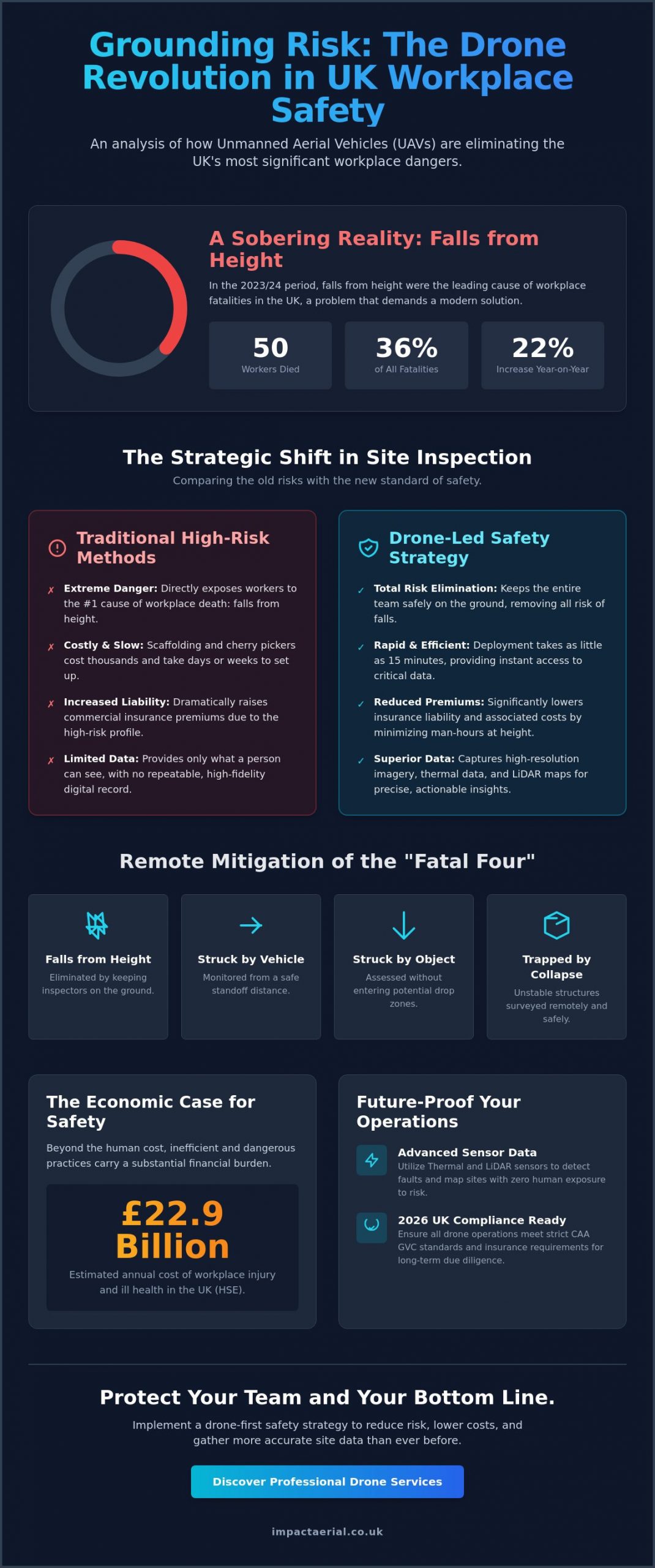
In the 2023/24 period, 50 workers in the UK died following a fall from height, accounting for a staggering 36% of all workplace fatalities. It’s a sobering statistic that highlights the inherent dangers of traditional inspection methods and the urgent necessity of reducing workplace risk with drones. You likely recognize the immense logistical pressure and financial burden of managing high-risk site surveys, especially when faced with the rising costs of scaffolding and increasing insurance liability concerns.
We’re here to show you that safety and efficiency don’t have to be a trade-off. This guide explains how commercial drone technology eliminates the need for ladders and manual climbing, providing a sophisticated path to total HSE and CAA compliance. By the end of this article, you’ll understand how to leverage the latest 2026 regulatory standards and advanced sensor data to protect your workforce while gathering more accurate site information than ever before. We’ll break down the strategic shift from hazardous manual inspections to precise, remote data collection that keeps your team firmly on the ground.
Key Takeaways
- Understand why transitioning to UAV-led inspections is a critical step in addressing the UK’s leading causes of workplace injury and fatality.
- Learn how drone commercial property surveys replace hazardous ladders and expensive scaffolding for both internal and external asset inspections.
- Discover the technical advantages of using thermal imaging and LiDAR to detect faults and map sites with zero human exposure to risk.
- Navigate the 2026 UK compliance landscape by ensuring your drone operations meet strict CAA GVC standards and insurance requirements.
- Gain actionable insights into reducing workplace risk with drones through a methodical, technology-driven safety strategy.
The State of Workplace Risk: Why Drones are Essential in 2026
Drone-based risk reduction involves deploying an Unmanned aerial vehicle (UAV) to execute complex tasks in hazardous environments that previously demanded human entry. This technology represents a fundamental shift in occupational safety. It’s about moving personnel away from the “danger zone” while maintaining high-fidelity data collection. By 2026, the integration of these systems has become a benchmark for professional site management across the UK.
The necessity for this shift is clear when examining the latest Health and Safety Executive (HSE) data. In the 2023/24 period, 50 workers in the UK died following a fall from height. This figure represents 36% of all workplace fatalities and a 22% increase from the previous year. Even with a slight decrease in total worker deaths to 124 in 2024/25, the risk associated with working at height remains the most significant threat to life in the construction and industrial sectors. Reducing workplace risk with drones provides a direct solution to these recurring tragedies.
Beyond the human tragedy, the economic impact is substantial. The HSE estimated the annual cost of workplace injury and ill health at £22.9 billion in 2025. A single incident can lead to massive insurance hikes, legal fees, and irreparable reputational damage that can haunt a business for years. Consequently, traditional access methods like scaffolding and cherry pickers are increasingly viewed as secondary options. They’re slow, expensive, and introduce unnecessary variables into the safety equation.
To better understand this concept, watch this helpful video:
The ‘Fatal Four’ and Remote Mitigation
The UK construction sector continues to grapple with the “fatal four”: falls from height, being struck by moving vehicles, being struck by moving objects, and being trapped by collapsing structures. Remote aerial perspectives allow managers to monitor these risks without placing a safety officer in harm’s way. Remote Risk Mitigation is the primary benefit of commercial UAVs, defined as the strategic removal of human personnel from high-hazard environments through the use of remote sensing technology. This proactive approach ensures that high-risk areas are inspected and managed from a safe, standoff distance.
Cost vs. Risk: The ROI of Drone Safety
The financial argument for reducing workplace risk with drones is as compelling as the safety case. Traditional scaffolding can take days or even weeks to erect, costing thousands before an inspection even begins. In contrast, a professional drone deployment can be completed in as little as 15 minutes. This drastic reduction in “man-hours at height” doesn’t just save time; it directly lowers commercial insurance premiums by minimizing the liability profile of the site. Furthermore, the data captured provides a repeatable, digital safety audit that serves as an indisputable record of compliance and due diligence for long-term regulatory requirements.
Eliminating High-Risk Activities with Drone Inspection Services
Traditional access equipment often creates more hazards than it solves. Commercial operators are increasingly reducing workplace risk with drones by replacing traditional access equipment with agile aerial platforms. This transition allows site managers to bypass the logistical nightmare of erecting scaffolding or hiring cherry pickers for routine checks. By keeping personnel on the ground, businesses don’t just speed up their workflows; they eliminate the primary variable in most site accidents. Real-time monitoring on live construction sites also allows safety officers to identify potential breaches as they happen, ensuring that protocols are followed without needing to walk through active danger zones.
Emergency assessments present another critical application for this technology. When a structure suffers fire damage or becomes unstable after a storm, sending a human inspector inside is often too dangerous. Drones provide an immediate visual link to the damage, allowing for an informed recovery plan without risking a single life. This technological shift is essential for reducing workplace risk with drones in environments where human presence is either impossible or prohibitively dangerous.
Roof and Facade Surveys: Safety at Scale
Deploying drone property surveys is the most effective method for assessing high-rise assets without the inherent dangers of manual climbing. These surveys eliminate the need for fragile roof walk-overs and manual gutter inspections, which are frequent sites of accidents. Instead of a worker balancing on a pitched roof, a pilot captures high-resolution 4K imagery from a safe distance. This detail allows for the identification of hairline cracks, loose tiles, or blocked drainage systems without any physical contact with the structure. It’s a meticulous approach that provides better data while maintaining a zero-risk profile for the workforce.
Internal and Confined Space Operations
Internal inspections present unique challenges that are often overlooked in safety discussions. Chimneys, tanks, attics, and silos are notoriously difficult to navigate. These areas often require breathing apparatus and specialist rescue teams to be on standby, adding significant cost and risk. By using protected-rotor drones, these confined spaces can be thoroughly inspected from the outside. These specialized aircraft can bounce off walls without crashing, making them ideal for internal surveys. Guidance from the UK Health and Safety Executive emphasizes the importance of avoiding confined space entry whenever a remote alternative exists.
Consider a recent project involving a large warehouse roof structure. Usually, such an inspection would require halting logistics operations below to clear a path for heavy lifting equipment. By using a drone, the survey was completed while operations continued as normal. The drone safely navigated the rafters, capturing every bolt and weld, while the ground team remained entirely out of the way. Partnering with a specialist for professional drone services ensures these high-risk tasks are handled with technical precision and total compliance.
Beyond Visuals: Specialized Sensors for Hazardous Environments
Advanced sensor payloads have transformed drones from simple cameras into sophisticated data-gathering instruments. While high-resolution video is useful for visual checks, the real power in reducing workplace risk with drones lies in the ability to “see” what’s invisible to the human eye. Thermal imaging, LiDAR, and gas detection sensors allow for the identification of structural, electrical, and chemical hazards before they manifest as critical failures. This proactive data collection keeps personnel safely outside the hazard perimeter, ensuring that interventions are planned based on precise evidence rather than guesswork.
As technology matures, AI-driven autonomous navigation plays an increasing role in flight safety. These systems can detect and avoid obstacles in real-time, significantly reducing pilot-related risks during complex maneuvers near sensitive infrastructure. By automating flight paths for repeatable missions, businesses ensure a consistent standard of data quality while minimizing the potential for human error in high-pressure environments. Gas and chemical sensing modules can also be integrated to identify leaks from a distance, preventing staff from being exposed to toxic fumes during initial site assessments.
Thermal Surveys for PV Solar Farms
Solar energy infrastructure presents unique safety challenges, particularly regarding high-voltage exposure. Professional pv solar farm thermal surveys identify “hot spots” that signify failing components or electrical imbalances. These anomalies are often precursors to fire hazards. By using thermal drones, technicians can inspect thousands of panels across vast acreage without ever walking through active high-voltage fields. It’s a meticulous process where thermal sensors identify sub-surface defects invisible to the naked eye, such as cell-level delamination or internal bypass diode failures, ensuring the site remains both productive and safe.
LiDAR and Digital Twins for Site Planning
Before any boots hit the ground on a new project, understanding the terrain is vital for safety. A specialized survey drone equipped with LiDAR can penetrate dense vegetation to map the true ground surface below. This capability is essential for identifying unstable ground, hidden pits, or steep gradients that could cause vehicle rollovers or falls. These LiDAR scans are used to create highly accurate 3D models or “digital twins” of the site. H&S managers use these models to conduct remote safety briefings, allowing teams to visualize the site’s hazards and plan safe access routes from the comfort of an office. This method of reducing workplace risk with drones ensures that every team member is fully briefed on site-specific dangers before they arrive at the location.
Implementing a Drone-First Safety Strategy: The UK Compliance Framework
Adopting an aerial strategy is a significant step toward reducing workplace risk with drones, but the hardware is only as safe as the operational framework supporting it. In the UK, commercial drone use is governed by strict Civil Aviation Authority (CAA) protocols that ensure every flight is conducted with the same level of scrutiny as manned aviation. A successful strategy requires a meticulous approach to pilot certification, comprehensive insurance, and the seamless integration of aerial data into your existing Health and Safety Management Systems (HSMS).
Professional operators don’t just launch a drone; they execute a detailed pre-flight risk assessment (PFRA) that accounts for weather, local obstacles, and airspace restrictions. This documentation is vital for maintaining a clear audit trail. It demonstrates that your business is meeting its duty of care under UK law. By standardizing these safety protocols, you ensure that reducing workplace risk with drones becomes a repeatable, reliable process rather than an ad-hoc activity.
Understanding CAA Regulations and Certifications
There’s a fundamental distinction between a basic UK drone license and professional GVC (General Visual Line of Sight Certificate) certification. While a Flyer ID is sufficient for basic operations, the GVC is the industry gold standard for complex commercial work, especially in congested areas or near restricted airspace. Hobbyist pilots often lack the specific training required to manage the unique risks of an industrial site, making them a significant liability. Professional certification ensures the pilot is current with 2026 regulations, including the mandatory use of Remote ID systems and UK class-marked hardware.
The Role of Professional Indemnity and Liability Insurance
Standard business insurance almost always excludes aviation-related activities. For high-risk industrial sites, a minimum of £5m commercial liability insurance is the baseline requirement. This specialist cover protects your business against the financial fallout of accidental damage or unforeseen incidents. When you hire a specialist, you mitigate your vicarious liability; the responsibility for the safe conduct of the flight rests with the certified operator. It’s essential to verify the validity of these certificates and insurance documents before every deployment to ensure total compliance with national safety standards.
Establishing a compliant aerial program protects your workforce and your bottom line. If you’re ready to enhance your safety protocols with expert support, contact us today to discuss our professional drone services.
Impact Aerial: Professional Risk Mitigation and Drone Services
Impact Aerial operates at the intersection of technical excellence and regulatory compliance. We don’t just provide imagery; we deliver a comprehensive framework for reducing workplace risk with drones across the UK. While we maintain a local focus on the West Midlands, our team provides nationwide coverage for sectors ranging from commercial property to large-scale energy projects. Every operation is handled by CAA GVC certified pilots who understand the nuances of industrial safety protocols. We manage the entire process from initial consultation through to post-production, ensuring that safety data is delivered in a format that’s immediately actionable for your team.
Our methodology is built on the principle of reassurance through expertise. We recognize that for a site manager, the primary concern is the legality and safety of the operation. By providing a structured service that includes detailed pre-flight planning and robust insurance coverage, we take the technical burden off your shoulders. This allows your business to focus on its core operations while we handle the complexities of aerial data collection and H&S compliance.
Commercial-Grade Hardware for Maximum Reliability
We utilize DJI Enterprise hardware because it offers the redundancy required for high-stakes environments. These aircraft feature dual-battery systems and multi-directional obstacle sensing to ensure maximum reliability during every flight. The inclusion of 4K HDR and high-zoom cameras allows for remote inspection detail that’s often superior to what a human eye can see from a ladder or scaffold. Our meticulous maintenance and safety check protocols mean that every piece of equipment is verified for airworthiness before it arrives on your site. This commitment to using high-tier hardware ensures that we capture precise data with zero compromise on safety.
Partnering for a Safer Workplace
We position ourselves as a technical extension of your own safety team. By working alongside H&S managers, we ensure that our drone commercial property surveys and construction site monitoring align with your specific risk assessments. Our track record in reducing “at-height” man-hours for UK clients demonstrates the tangible impact of an aerial-first approach. We provide the visual and thermal evidence needed to make critical decisions without exposing staff to unnecessary danger. This collaborative process ensures that the data we collect is integrated seamlessly into your existing safety management systems. Contact Impact Aerial today for a professional safety consultation to see how we can strengthen your compliance and protect your workforce through reducing workplace risk with drones.
Securing the Future of Industrial Safety
The transition toward aerial data collection is no longer a luxury for UK enterprises; it’s a fundamental requirement for maintaining a competitive and safe operational environment. By removing personnel from hazardous locations and utilizing advanced sensors like LiDAR and thermal imaging, you protect your most valuable asset: your people. Reducing workplace risk with drones represents a strategic investment in long-term compliance and operational efficiency that pays dividends in both safety and site productivity.
Impact Aerial provides the technical expertise and regulatory assurance needed to navigate this transition safely. Our team utilizes DJI Enterprise Grade Hardware and carries £5m Commercial Liability Insurance to ensure every project is fully protected. With CAA GVC Certified Pilots at the helm, we deliver the precision data your Health and Safety Management Systems require to function at peak performance.
Request a Professional Drone Safety Consultation today to integrate these advanced solutions into your site protocols. It’s time to elevate your safety standards and secure your workforce for the years ahead. We look forward to helping you build a safer, more efficient future.
Frequently Asked Questions
How do drones specifically reduce the risk of working at height?
Drones reduce the risk of working at height by removing the requirement for personnel to leave the ground. By acting as a remote eye, these aircraft capture high-definition data from positions that would otherwise require ladders or expensive access platforms. This technological shift directly addresses the leading cause of industrial fatalities in the UK by ensuring that high-altitude inspections are conducted with zero human exposure to fall hazards.
Are drones safer than traditional scaffolding for building inspections?
Drones provide a safer alternative to scaffolding because they eliminate the prolonged exposure associated with manual climbing. Scaffolding is labor-intensive to erect and introduces additional risks during the assembly phase. In contrast, a drone survey is a non-contact method that keeps your workforce safe on the ground. Reducing workplace risk with drones ensures that inspections are completed without the structural and height-related hazards inherent to traditional access methods.
What UK regulations govern the use of drones for workplace safety?
Commercial drone operations in the UK are strictly regulated by the Civil Aviation Authority (CAA). As of 2026, all operators must possess valid Flyer and Operator IDs and utilize hardware that complies with current UK class-marking and Remote ID requirements. Reducing workplace risk with drones requires pilots to hold a GVC, which allows for complex operations in congested areas while ensuring every flight meets national legal standards.
Can drones be used for internal safety inspections in confined spaces?
Specialized drones can navigate internal and confined spaces like tanks, silos, and chimneys without human entry. These aircraft often feature protective cages or collision-tolerant sensors that allow them to fly safely in dark, cramped, or structurally compromised environments. This capability is vital for identifying internal defects or leaks while keeping staff away from potentially toxic atmospheres or hazardous confined space conditions that traditionally require specialist rescue teams.
What kind of insurance should a professional drone service have?
A professional drone service must hold specialist commercial liability insurance that meets EC 785/2004 standards. For high-risk industrial or construction sites, a minimum of £5 million in public liability cover is the standard expectation. This specialist insurance is essential because standard business policies often exclude aerial activities, leaving your company vulnerable to significant financial and legal liability in the event of an incident during an inspection.
How does thermal imaging on drones improve workplace safety?
Thermal sensors improve safety by detecting heat signatures associated with electrical faults, friction, or insulation breaches. These hotspots are often precursors to fires or catastrophic equipment failures. By identifying these issues from a safe distance, drones allow managers to plan targeted maintenance. This proactive approach prevents the need for technicians to perform diagnostic checks in high-voltage areas or near pressurized systems until the site is secured.
Is it more cost-effective to use drones for safety audits than manual inspections?
Drones offer superior cost-efficiency by drastically reducing the time and equipment required for safety audits. Traditional manual inspections often involve significant downtime and the high rental costs of cherry pickers or scaffolding. A drone can often complete a comprehensive site survey in under an hour. This efficiency lowers the overall cost per inspection while providing more frequent, high-quality data for your internal health and safety records.
What qualifications should I look for when hiring a drone pilot for a high-risk site?
When hiring for a high-risk site, you should verify the pilot holds a CAA GVC (General Visual Line of Sight Certificate). This certification is the professional benchmark for commercial operators in the UK. It ensures the pilot has undergone rigorous training in risk mitigation and airspace management. Additionally, check for a valid Operator ID and proof of specialist insurance to ensure the operation is fully compliant with current 2026 aviation laws.
 2 Norton Drive, Wythall, Birmingham, B47 6HH Company registration number: 11138586. VAT Number: 366 9068 55


