Aerial Inspection of Power Lines: The Professional Guide to Drone Utility Surveys

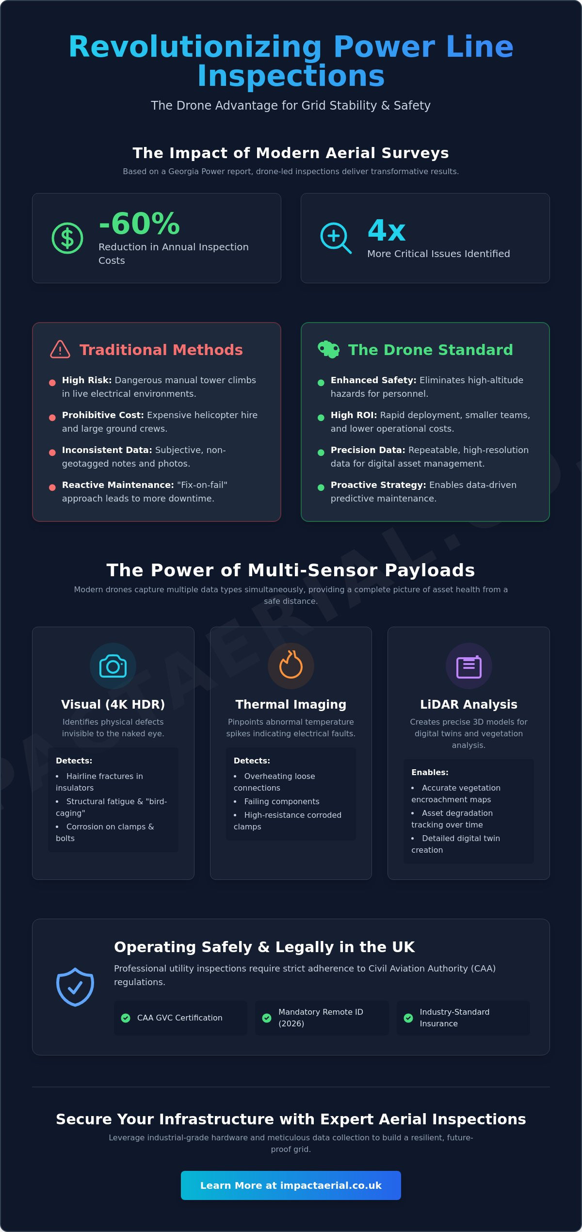
Georgia Power recently reported cutting annual inspection costs by 60% while identifying four times more critical issues compared to traditional methods. This data illustrates why the aerial inspection of power lines has transitioned from a niche innovation to a critical requirement for grid stability. You’re likely familiar with the inherent dangers of manual tower climbs and the inconsistent data often produced by ground-based visual checks, not to mention the logistical strain of coordinating helicopter surveys in remote terrain.

It’s clear that the utility sector requires a more precise, repeatable, and safety-conscious approach to asset management. This professional guide demonstrates how drone technology is revolutionising maintenance through thermal precision and high-resolution digitisation. We’ll examine the technical requirements for 2026, including mandatory Remote ID and GVC certifications, while exploring how advanced sensors like the DJI Zenmuse H30T deliver the granular data needed for predictive maintenance. By the end of this article, you’ll understand how to integrate these compliant, data-centric processes into your existing workflow to secure your infrastructure and protect your personnel.

Key Takeaways

  • Understand how the transition to drone-led aerial inspection of power lines enhances data accuracy while replacing high-risk manual climbing and expensive helicopter hire.
  • Explore the precision of multi-sensor payloads that combine thermal imaging and 4K HDR visual data to identify corrosion and structural defects invisible to the naked eye.
  • Recognise the safety and efficiency gains achieved through non-contact surveys, which eliminate high-altitude hazards for personnel and reduce operational downtime.
  • Identify the critical regulatory requirements for commercial drone operations, including CAA GVC certification and the importance of industry-standard liability insurance.
  • Discover how leveraging industrial-grade hardware and meticulous data collection processes supports digitised asset management and proactive maintenance strategies.

The Evolution of Aerial Inspection of Power Lines

Modern infrastructure management has moved far beyond ground-based visual checks and manual reporting. In its contemporary form, the aerial inspection of power lines utilises sophisticated Unmanned Aerial Vehicles (UAVs) to perform detailed, repeatable audits of transmission and distribution networks. This process is rooted in the principles of a professional aerial survey, where high-resolution sensors capture data that was previously inaccessible or too dangerous to obtain. By 2026, the UK regulatory landscape has matured to support this shift, with the Civil Aviation Authority (CAA) implementing mandatory Remote ID and class markings (UK0–UK6) that provide a clear safety framework for industrial-grade operations.

To better understand this concept, watch this helpful video:

The role of high-resolution 4K imagery is central to this evolution. It allows engineers to identify structural fatigue, such as hairline fractures in ceramic insulators or “bird-caging” in wire strands, from a safe standoff distance. The transition toward the aerial inspection of power lines represents a fundamental move from reactive “fix-on-fail” maintenance to a data-driven, proactive strategy that prioritises network resilience and personnel safety.

The Limitations of Traditional Inspection Methods

Traditional methods are increasingly viewed as inefficient and high-risk. Helicopter-based surveys carry a significant carbon footprint and involve prohibitive hiring costs that often limit the frequency of inspections. Beyond the financial burden, sending lineworkers to climb towers in “live” electrical environments presents inherent safety risks that modern utility companies can’t ignore. Manual inspections also suffer from subjective data collection. A technician’s handwritten notes or handheld photographs often lack the geospatial precision required to build a true digital twin of the asset, making it difficult to track degradation over time accurately.

Why Drones are the New Standard for Utility Surveys

Drones have set a new benchmark for ROI and operational flexibility. They offer rapid deployment capabilities, which are essential during emergency storm damage assessments where every minute of downtime impacts thousands of customers. Unlike traditional aircraft, a UAV can hover steadily to capture multi-angle perspectives of pylons, cross-arms, and insulators. This level of detail ensures that even the smallest signs of corrosion are documented. Because drone surveys require smaller teams and no aviation fuel, they provide a much higher ROI, allowing utility providers to increase inspection frequency without inflating their operational budgets. The result is a more reliable grid and a significantly safer working environment for maintenance teams.

Advanced UAV Sensors: Visual, Thermal, and LiDAR Analysis

The technical efficacy of a utility survey depends entirely on the payload. Modern enterprise platforms, such as the DJI Matrice 350 RTK, utilise multi-sensor payloads that allow operators to capture visual and thermal data simultaneously. This synchronised approach is essential for the aerial inspection of power lines because it provides immediate context. While a thermal sensor might detect an abnormal temperature spike, the high-resolution visual camera confirms whether the cause is a physical defect, such as a loose connection or a corroded clamp. Using 4K HDR cameras, teams can identify “invisible” issues including hairline cracks in porcelain insulators and structural fatigue in pylon cross-arms from a safe standoff distance.

Research into an automated drone inspection system by national laboratories highlights how these advanced sensors are becoming the backbone of grid resilience. By automating the data capture process, utilities can ensure that every centimetre of the conductor is analysed with mathematical precision. This level of detail is simply not achievable through traditional ground-based binoculars or rapid helicopter flyovers.

Detecting Thermal Anomalies in Live Infrastructure

Infrared thermography allows our teams to see the heat signatures emitted by electrical components. In a live environment, equipment like knife switches and transformers shouldn’t exhibit significant temperature variances from their surroundings. When a “hotspot” appears, it typically indicates high electrical resistance or impending component failure. Identifying these anomalies early prevents catastrophic grid outages and costly emergency repairs. Maintenance tasks are prioritised by calculating the thermal delta-T, which is the temperature difference between the suspect component and a functional reference point on the same circuit. For complex assets, our post-production services provide the detailed analysis required to turn these thermal readings into actionable maintenance reports.

LiDAR and Digital Twins for Grid Resilience

LiDAR (Light Detection and Ranging) integration has revolutionised how we map the physical relationship between power lines and their environment. By emitting thousands of laser pulses per second, LiDAR sensors create highly accurate 3D point clouds of transmission towers and the surrounding terrain. These models are used to develop digital twins, allowing engineers to simulate weather impact, such as wind-induced “galloping” of lines or heavy ice loading. This data is easily integrated into existing Geographic Information Systems (GIS), providing asset managers with a georeferenced, centimetre-accurate overview of their entire network. This digitised approach ensures that vegetation management and structural reinforcements are based on objective, high-fidelity data rather than seasonal estimates.

Aerial Inspection of Power Lines: The Professional Guide to Drone Utility Surveys

The Strategic Advantages of Drone-Led Utility Surveys

Adopting a drone-first strategy offers more than just technical precision; it provides a structural shift in how utilities manage risk. The aerial inspection of power lines allows for non-contact assessments, meaning infrastructure remains “live” while data is collected. This significantly reduces operational downtime compared to traditional methods that might require circuit isolation for safe manual access. It’s an approach that mirrors the efficiencies seen by global energy leaders who’ve reported identifying four times more critical issues than traditional ground-based methods.

Safety remains the primary driver for this technological transition. By eliminating the need for high-altitude manual work, companies protect their most valuable assets: their people. Personnel no longer need to scale towers in hazardous conditions when a UAV can deliver sub-millimetre visual detail from the air. This reduction in physical risk is coupled with an increase in data quality, ensuring that no defect goes undocumented due to human fatigue or perspective limitations.

We’re seeing a rapid transition toward predictive maintenance models. Instead of fixing components after they fail, digital data allows engineers to spot trends and intervene early. This data-centric approach to the aerial inspection of power lines is becoming more accessible as the UK government streamlines CAA compliance for drone inspections, particularly for operations in atypical air environments. These regulatory shifts enable more frequent surveys, creating a denser data set for long-term asset management.

There’s also a clear environmental advantage. Drones produce negligible noise pollution and have zero direct carbon emissions during flight. This stands in stark contrast to the heavy fuel consumption and acoustic disruption associated with industrial helicopters, making UAVs the preferred choice for utilities aiming to meet strict ESG (Environmental, Social, and Governance) targets.

Foliage Encroachment and Vegetation Management

Overgrown vegetation is a leading cause of network faults, especially during the UK storm season. Drones equipped with high-resolution cameras or LiDAR can quickly identify encroaching branches that pose a direct risk to overhead lines. This automated foliage analysis allows for targeted trimming schedules rather than broad, expensive clearance programmes. For a broader look at how these techniques apply to other sectors, our guide on drone survey methodologies provides extensive context on professional data collection.

Emergency Response and Storm Damage Assessment

When severe weather hits, speed is everything. Drones can be deployed within minutes of a storm passing to assess damage in flooded or otherwise inaccessible areas. They provide real-time situational awareness to ground repair crews, identifying exactly where a line is down or a pylon is compromised. This targeted intelligence ensures that resources are sent to the most critical points immediately, shortening the duration of power outages and ensuring that technicians don’t enter dangerous zones without prior knowledge of the hazards.

Operational Safety and CAA Compliance in the UK

Safety in utility environments isn’t just a protocol; it’s a legal and operational mandate. For any organisation commissioning the aerial inspection of power lines, compliance with the UK Civil Aviation Authority (CAA) is the first metric of professional competence. As of January 1, 2026, the regulatory landscape has become significantly more stringent. Every commercial operation now requires a specific class-marked drone and mandatory Remote ID broadcasting. Navigating these requirements requires a partner who understands the nuances of the latest drone license regulations, ensuring that all flights are fully documented and legally compliant.

The Importance of GVC Certified Pilots

Operating a UAV within the high-electromagnetic fields of a pylon network requires specialised training that exceeds standard flyer IDs. A General Visual Line of Sight Certificate (GVC) is essential for this work. This certification demonstrates that the pilot has undergone rigorous theoretical and practical testing, specifically regarding risk mitigation in complex airspaces. For critical national infrastructure, uncertified or “hobbyist” pilots represent an unacceptable risk. GVC-certified pilots are trained to handle signal interference and maintain precise control in the congested environments typical of utility surveys. They possess the technical expertise to manage the unique flight dynamics encountered near high-voltage conductors.

Insurance and Liability for High-Voltage Environments

Standard drone insurance policies often exclude or limit coverage when operating near high-voltage assets. In the utility sector, £5m commercial liability insurance has become the industry standard for professional contractors. This isn’t just a figure; it’s a comprehensive indemnity package that protects asset managers from operational risks. Our coverage at Impact Aerial is designed specifically for industrial applications, providing reassurance that all liabilities are managed according to EC Regulation 785/2004. This level of protection ensures that even in the unlikely event of equipment failure, the client’s financial and structural interests are fully shielded.

Every survey begins long before the drone leaves the ground. Professional risk mitigation involves detailed pre-flight planning and site-specific assessments. We evaluate local topography, weather patterns, and potential “live” hazards to create a robust flight plan. This methodical approach ensures that the aerial inspection of power lines is conducted without compromising the integrity of the grid or the safety of the public. We prioritise transparency and meticulous documentation throughout the project lifecycle.

If you require a compliant, safety-first partner for your next infrastructure project, contact Impact Aerial today to discuss our certified utility inspection services.

Partnering with Impact Aerial for Utility Infrastructure Monitoring

Impact Aerial provides comprehensive expertise in high-resolution data collection for the UK utility sector. Our approach to the aerial inspection of power lines is built on a foundation of technical precision and regulatory compliance. We don’t just capture images; we provide a structured pathway from raw data to actionable maintenance insights. Through our dedicated post-production services, we transform complex thermal and visual captures into detailed reports that asset managers use to prioritise repairs and justify infrastructure investments. This methodical process ensures that every pylon and conductor is accounted for within a digitised management framework.

Our capabilities extend beyond the energy sector to provide specialised drone services for property and construction clients. Whether it’s monitoring a large-scale development or conducting a commercial property survey, our team applies the same industrial-grade standards to every project. We’re committed to delivering high-tier quality that supports long-term asset health and operational safety.

Our Technology Stack: DJI Matrice and Beyond

We utilise the DJI Matrice 350 RTK as our primary platform for the aerial inspection of power lines. This commercial-grade drone is equipped with 4K HDR cameras and specialised thermal sensors, allowing us to document structural details with exceptional clarity. The integration of Real-Time Kinematic (RTK) positioning is a critical feature of our technology stack. It provides centimetre-level geospatial accuracy for every data point collected, which is essential for building accurate digital twins. For clients requiring high-end visual documentation or marketing materials, our aerial filming drone capabilities deliver cinematic-quality output without sacrificing technical detail.

Start Your Utility Inspection Project Today

Every project begins with a technical consultation to understand your specific grid or pylon requirements. We assess the scope of the network and identify any unique site challenges to ensure a safe and efficient deployment. Operating from our central base in Birmingham, we provide UK-wide coverage, delivering professional surveys to the West Midlands and across the country. We’re proud of our professional affiliations and our commitment to maintaining the highest industry standards for every client. Our meticulous planning process ensures that we meet all regulatory requirements while delivering tangible benefits to your business.

Our team is ready to assist you in transitioning to a more proactive, data-driven asset management strategy. Contact Impact Aerial for a professional utility survey quote to secure your infrastructure with the precision of drone technology.

Securing the Future of Utility Infrastructure

The transition from reactive maintenance to a proactive, digitised strategy is no longer a luxury for utility providers; it’s an operational necessity. By integrating advanced sensors and automated data analysis, the aerial inspection of power lines provides a level of structural insight that traditional methods simply cannot match. These technologies don’t just identify defects; they build a foundation for long-term grid resilience while keeping your personnel out of high-risk environments.

Impact Aerial is ready to support your infrastructure goals with a meticulous, safety-first approach. Our team of CAA GVC Certified Pilots operates with £5m commercial liability insurance, ensuring full indemnity and compliance for every survey. Based in Birmingham, we provide a rapid response service across the UK to help you maintain critical assets with absolute precision. Whether you’re managing a local distribution network or a national transmission grid, we deliver the high-tier data you need to make informed decisions.

Request a Professional Power Line Inspection Quote

We look forward to helping you modernise your asset management workflow and secure your network for the years ahead.

Frequently Asked Questions

How much does a drone power line inspection cost in the UK?

Project costs are determined by the specific scope of the survey, including the total mileage of the network and the number of individual structures requiring assessment. Factors such as terrain complexity and the requirement for multi-sensor payloads like LiDAR or thermal imaging also influence the final investment. We provide bespoke quotes that reflect the technical requirements and regulatory compliance of each project to ensure a high-tier, professional output for our clients.

Can drones inspect power lines while they are live?

Drones are specifically engineered to conduct an aerial inspection of power lines while the infrastructure remains fully operational. This non-contact method eliminates the need for costly circuit isolation and prevents service interruptions for end-users. Professional enterprise UAVs are equipped with electromagnetic interference (EMI) shielding, allowing them to maintain stable flight and capture high-fidelity data even when operating in close proximity to high-voltage conductors.

What is the accuracy of thermal imaging in detecting power line faults?

Thermal sensors used in professional utility surveys are incredibly precise, often capable of detecting temperature variances as small as 30mK. This level of sensitivity allows our analysts to identify subtle hotspots in components like insulators and bushings that aren’t visible to the naked eye. By measuring the thermal delta-T, we provide objective data that helps maintenance teams prioritise interventions before a catastrophic equipment failure occurs on the grid.

Do I need a special permit for drone surveys near pylons?

Commercial drone operations near critical national infrastructure require specific legal authorisations. In the UK, pilots must hold a General Visual Line of Sight Certificate (GVC) and operate under an Operational Authorisation from the Civil Aviation Authority (CAA). For complex or congested areas, additional risk assessments and flight notifications are mandatory to ensure the legality and safety of the survey. We manage all regulatory compliance and site-specific permissions as part of our professional service.

How long does it take to complete an aerial inspection of a transmission line?

The speed of an aerial inspection of power lines is significantly higher than traditional ground-based or manual climbing methods. Verified industry data shows that a professional drone team can inspect an average of 14 miles of line per day, with individual pylon assessments typically taking about seven minutes. This efficiency allows utility providers to complete entire network audits in a fraction of the time required for legacy inspection cycles, reducing overall operational strain.

What happens if a drone detects a fault during a survey?

If a fault is identified during a flight, it’s immediately documented with high-resolution visual and thermal imagery. Every capture is georeferenced, providing the exact coordinates of the issue for maintenance crews. Following the survey, our post-production team conducts a detailed analysis to categorise the severity of the defect. This information is compiled into a prioritised report, allowing asset managers to deploy repair teams to the most critical points first to maintain grid stability.

Can drones perform inspections in bad weather or high winds?

Industrial-grade drones like the DJI Matrice 350 RTK are designed with high IP ratings, allowing them to operate in light rain and winds up to 12 metres per second. While the hardware is robust, we typically schedule surveys during stable weather conditions to ensure the highest possible data quality. High winds or heavy precipitation can degrade thermal readings and visual clarity, so we prioritise safety and precision by monitoring local forecasts meticulously before every deployment.

How is the data from a power line drone survey delivered to the client?

We deliver survey data through secure digital platforms, providing clients with a comprehensive suite of high-resolution visual and thermal reports. This data is formatted for seamless integration into existing Geographic Information Systems (GIS) or asset management software. By providing georeferenced 4K imagery and detailed thermal analysis, we ensure that your engineering teams have a clear, actionable overview of the grid’s health that’s easy to share, archive, and use for predictive maintenance.

Why Hire a GVC Certified Drone Pilot in the UK? (2026 Professional Guide)

Does a basic drone license actually protect your business from a heavy CAA fine if an incident occurs on a congested construction site? You likely recognize that aerial technology provides invaluable data for PV solar farm surveys or commercial property inspections, but the regulatory landscape in 2026 can feel like a legal minefield. With the drone registration threshold now lowered to just 100g and new Remote ID mandates in full effect, the gap between a hobbyist and a professional has never been wider.

It’s natural to worry about insurance validity or the complexities of flying near people, but hiring the right expert removes that burden. This guide explains exactly why hire a gvc certified drone pilot uk to mitigate your operational risks and ensure you receive high-tier 4K or thermal data. We’ll explore how a GVC holder navigates the Specific Category requirements, manages rigorous risk assessments, and utilizes UK class-marked hardware to keep your project fully compliant and professionally executed.

Key Takeaways

  • Understand why hire a gvc certified drone pilot uk to unlock the Specific Category, which is required for complex missions that basic licenses cannot support.
  • Learn how GVC certification permits the legal operation of enterprise drones in congested areas like town centers and active construction sites.
  • Discover how to verify a pilot’s Operational Authorisation and insurance to protect your business from legal liability and ensure policy validity.
  • Identify critical professional documentation, including the PDRA-01 and the Operations Manual, to guarantee your contractor meets 2026 CAA standards.
  • Explore how specialized hardware delivers the precision 4K HDR and thermal data necessary for commercial property and PV solar farm surveys.

Understanding the GVC: Beyond the Basic UK Drone License

The General Visual Line of Sight Certificate (GVC) represents the technical benchmark for professional drone operations in the British Isles. It isn’t a mere “license” in the traditional sense; it’s a comprehensive competency qualification. Since the regulatory shift on January 1, 2026, understanding the nuances of UK drone operational categories has become a prerequisite for any business commissioning aerial work. While anyone can obtain a basic Flyer ID for free, the GVC is the mandatory foundation for pilots seeking an Operational Authorisation from the Civil Aviation Authority (CAA).

This distinction is vital because most high-value commercial projects, such as PV solar farm thermal surveys or construction site monitoring, operate within the “Specific Category.” This category covers flights that present a higher risk than standard recreational “Open Category” operations. When you consider why hire a gvc certified drone pilot uk, the primary reason is the ability to legally fly in areas where hobbyists are strictly prohibited. A GVC holder has undergone rigorous theory and practical assessments to prove they can safely manage aircraft up to 25kg in complex environments.

To better understand how these qualifications differ and what the training involves, watch this helpful guide:

GVC vs. A2 CofC: Which Does Your Project Need?

The A2 Certificate of Competency (A2 CofC) is often sufficient for lightweight drones in low-risk environments. It’s suitable for small-scale aerial filming where the drone stays far from uninvolved people. However, the GVC is the necessary standard for heavier commercial-grade drones and complex flights near buildings or active infrastructure. Most construction and commercial property surveys require GVC-level oversight because the operational risks demand the advanced mitigation strategies only taught at this level. If your project involves a town center or a congested industrial site, an A2 CofC pilot likely won’t have the legal permissions to get the job done safely.

The Role of the Civil Aviation Authority (CAA)

The CAA regulates the UK’s airspace to ensure that every drone flight is conducted without endangering the public or manned aviation. Every professional pilot must maintain a valid Flyer ID and an Operator ID, which currently costs £12.34 per year. The GVC acts as the CAA’s verification that a pilot is qualified to operate under a specific Operational Authorisation. Hiring an uncertified pilot isn’t just a safety risk; it’s a significant legal liability. If an incident occurs, the CAA can issue unlimited fines to businesses that fail to demonstrate proper “duty of care” when selecting their contractors. It’s your responsibility to ensure the pilot you hire has the credentials to match the complexity of the task.

The Commercial ‘Unlocks’: What GVC Pilots Can Do That Others Can’t

The General Visual Line of Sight Certificate (GVC) isn’t just a badge of expertise; it’s a legal key that unlocks restricted airspace and complex operational environments. While pilots in the Open Category are often restricted by drone weight or large distance buffers from uninvolved people, GVC holders operate under a different set of rules. This qualification allows for the safe operation of commercial-grade aircraft weighing up to 25kg. This weight capacity is essential for carrying the high-end thermal sensors and cinema-grade cameras required for professional-grade output. You can review the official GVC qualification details to see how this certificate serves as the backbone for advanced UK drone operations.

The most significant advantage for your business is the pairing of a GVC with a PDRA-01 (Pre-Defined Risk Assessment). This is the standard permission that allows a pilot to fly in congested areas. If your project requires capturing data in a city center or on a busy industrial estate, this is exactly why hire a gvc certified drone pilot uk. Under the current 2026 regulations, GVC pilots can fly closer to uninvolved persons than standard hobbyist rules allow, provided they follow the strict safety protocols outlined in their CAA-approved documentation. They don’t just fly; they manage the legal and physical risks of the flight path.

Urban Operations and Congested Areas

Major infrastructure projects in cities like London or Birmingham present unique challenges that an uncertified pilot simply cannot handle. You can’t launch a drone in a busy metropolitan area without a robust, site-specific flight plan. GVC pilots use their Operations Manual to define precise safety buffers, ensuring they maintain the required “duty of care” without sacrificing shot quality. They handle the complex liaison with local authorities and manage the ground-level safety teams necessary for urban flight success. If you’re planning a project in a high-traffic area, our team can help you assess your site-specific requirements.

Industrial Applications: Surveys and Inspections

Precision is the primary requirement for industrial clients. Executing high-detail drone surveys on active construction sites requires a pilot who understands how to manage complex airspace alongside heavy machinery. Whether it’s a PV solar farm thermal inspection or LiDAR data collection for 3D mapping, GVC pilots provide the professional-grade data needed for critical engineering decisions. Their advanced training ensures they can operate safely near sensitive infrastructure where any operational failure would have significant financial or safety repercussions. They provide the reliability that a hobbyist-level operator cannot guarantee.

Risk Mitigation: Why CAA Compliance Protects Your Business

When a business commissions a drone operation, they aren’t just buying data; they’re assuming a degree of legal responsibility. Under UK law, the person or company hiring a contractor has a “Duty of Care” to ensure that the contractor is competent and legally compliant. This is the fundamental reason why hire a gvc certified drone pilot uk. If an incident occurs on your site and the pilot lacks the correct Operational Authorisation, the legal repercussions can extend directly to your organization. A GVC-certified pilot acts as a safeguard, ensuring that every flight is conducted within the strict parameters of the law.

Professional-grade data collection, such as PV solar farm thermal surveys or construction monitoring, requires more than just a skilled hand; it requires valid commercial insurance. Most businesses don’t realize that standard drone insurance policies are often voided if the pilot operates outside the scope of their legal certification. The CAA provides Official CAA GVC Information which details the rigorous competency standards pilots must meet. This certification proves to both the regulator and your insurance provider that the pilot is a “competent person” capable of managing high-risk flights in the Specific Category.

The £5m Commercial Liability Standard

Commercial sites typically require a minimum of £5 million in public liability insurance. To meet the legal requirements for commercial drone work in the UK, insurance must comply with Regulation (EC) 785/2004. Hobbyist policies simply don’t offer this level of protection. By hiring a GVC-certified professional, you ensure that the aircraft is covered for third-party damage and bodily injury. This protects your project’s financial stability and provides the psychological comfort that comes from knowing you’re working with a vetted specialist.

Safety Protocols and Risk Assessments

A GVC pilot acts as the dedicated Safety Officer for the duration of the flight. Their process begins long before the drone leaves the ground. They conduct detailed pre-flight planning, which involves reviewing aeronautical charts, NOTAMs (Notices to Airmen), and site-specific hazards. On the day of the operation, they perform dynamic risk assessments to account for shifting weather conditions or the presence of uninvolved persons. This meticulous approach mitigates the PR risk of intrusive or illegal flights that could damage your brand’s reputation. A professional pilot has the technical expertise to say “no” to a flight if it’s unsafe, prioritizing the security of your site over a risky shot.

Evaluating Drone Providers: Operations Manuals and PDRA-01

Identifying a qualified pilot requires looking beyond their portfolio of cinematic shots. In the professional drone industry, the quality of a provider’s documentation is just as critical as their flight skill. A primary reason why hire a gvc certified drone pilot uk is the assurance that they operate under a robust, CAA-approved framework. This framework is anchored by two essential components: the Operations Manual and the PDRA-01 (Pre-Defined Risk Assessment). These documents prove that the pilot has moved beyond hobbyist flying and is operating as a legitimate aviation entity.

The PDRA-01 is the standard operational authorisation for professional pilots in the UK. It grants the legal permission to conduct Visual Line of Sight (VLOS) flights in congested areas, provided the pilot maintains a safe distance from uninvolved persons. Before you sign a contract, you should verify the pilot’s credentials on the official CAA register. A professional will always be happy to provide their Flyer ID and Operator ID, which currently requires an annual renewal fee of £12.34 to remain active. If a provider cannot produce these details or explain their current authorisation status, they aren’t equipped for commercial work.

The Operations Manual: The Pilot’s ‘Bible’

The Operations Manual is a comprehensive document, often exceeding 50 pages, that details every safety protocol and emergency procedure the pilot follows. The CAA requires this manual for any operator seeking an Operational Authorisation in the Specific Category. It ensures absolute consistency across different flight teams and projects. When evaluating a provider, ask if their manual has been updated to reflect the 2026 regulations, including the new requirements for Remote ID and UK class-marked hardware. A current manual demonstrates that the pilot is meticulous and stays ahead of shifting industry standards.

Vetting Your Drone Partner

Technical proficiency in one sector doesn’t always translate to another. You should ensure your chosen pilot has specific experience with professional drone services relevant to your industry. For example, the skills required for a cinema-grade aerial film are different from those needed for a high-precision 3D mapping project. Confirm that the team uses commercial-grade hardware, such as DJI Enterprise models, which offer the redundancy and sensor quality necessary for high-stakes surveys. If you’re unsure about the technical requirements for your project, you can consult with our certified flight team to review your site-specific needs.

During your initial consultation, ask the following key questions:

  • Can you provide a copy of your current CAA Operational Authorisation?
  • Does your insurance explicitly cover the specific location and flight type?
  • How do you handle dynamic risk assessments if site conditions change suddenly?
  • What is your protocol for managing data security and client confidentiality?

Why Impact Aerial is the UK’s Trusted GVC Partner

Impact Aerial operates with a clear mandate: to provide the highest standard of aerial data while maintaining absolute regulatory compliance. While previous sections of this guide detailed the legal necessity of certification, our focus is on the practical application of these standards. Our flight teams are entirely GVC-certified, ensuring that every mission, from a complex PV solar farm thermal survey to construction site monitoring, adheres to current 2026 CAA protocols. This is fundamentally why hire a gvc certified drone pilot uk through Impact Aerial; you aren’t just hiring a camera operator, but a technical consultant who understands the intersection of aviation law and data precision.

Based in the West Midlands, we provide nationwide coverage across the UK, bringing professional-grade aerial solutions to diverse industrial and creative sectors. We manage the entire lifecycle of your project. This includes securing site-specific CAA permissions, conducting detailed risk assessments, and delivering final post-production services. By centralizing these responsibilities, we remove the administrative burden from your team, allowing you to focus on the insights our data provides. Our meticulous approach ensures that your project is not only visually impressive but also fully compliant with the retained UK Regulations (EU) 2019/945 and 2019/947.

Enterprise Technology for Better Results

Superior results require more than just a certificate; they require the right tools for the environment. We utilize DJI Enterprise hardware equipped with RTK (Real-Time Kinematic) positioning to deliver centimeter-level accuracy for survey work. This level of precision is unattainable with consumer-grade drones. When it comes to visual storytelling, our cinematic drone video stands out because we use high-end sensors capable of capturing 4K HDR detail even in challenging lighting. These enterprise sensors allow us to identify thermal anomalies in solar arrays or structural defects in commercial properties that standard equipment would simply miss.

Start Your Compliant Project Today

Every project begins with a detailed consultation to understand your specific data requirements and site constraints. We don’t believe in a one-size-fits-all approach. Instead, we provide bespoke quotes that reflect the complexity and scale of your operation. Whether you need high-resolution mapping or immersive virtual tours, our process is designed to give you peace of mind. We handle the risk and the paperwork so that you receive professional-grade, actionable data. Our commitment to safety and precision makes us the preferred partner for businesses that value technical excellence.

Don’t leave your project’s legality or data quality to chance. Contact Impact Aerial for a GVC-certified drone pilot today to discuss your next commercial project and secure the aerial perspectives your business requires.

Securing Your Project’s Future with Certified Aerial Expertise

The regulatory landscape of 2026 makes it clear that professional drone operations require more than just technical skill; they demand a rigorous commitment to aviation law and safety. You now understand why hire a gvc certified drone pilot uk to navigate the complexities of the Specific Category and protect your organization from significant legal liability. Choosing a qualified partner ensures that your data collection is legally sound, your insurance remains valid, and your project site stays secure throughout the flight operation.

Impact Aerial provides the technical consultancy and operational excellence your project deserves. Our CAA GVC Certified Pilots utilize a DJI Enterprise Hardware Fleet to deliver precision data while maintaining £5m Commercial Liability Insurance for your total peace of mind. We handle the permissions and the risk so you can focus on the results. It’s time to elevate your project standards with a team that values compliance as much as visual quality. We look forward to helping you capture the perspectives your business needs to succeed.

Book a GVC Certified Pilot for Your UK Project

Frequently Asked Questions

Is a GVC drone license a legal requirement for commercial work in the UK?

A GVC is not a blanket legal requirement for every drone flight, but it’s mandatory for any operation within the Specific Category. If your project involves flying heavier drones or operating near people in congested areas, the pilot must hold this qualification. Commercial work in the Open Category is possible with an A2 CofC, but it lacks the operational flexibility required for most industrial or urban projects.

Can a pilot with only an A2 CofC fly on a construction site?

A pilot with an A2 CofC can fly on a construction site, but they’re limited by strict distance requirements from uninvolved persons. For example, they can’t fly drones over 250g within 30 meters of people. On a busy site, these buffers are often impossible to maintain without halting work. This is why hire a gvc certified drone pilot uk for construction monitoring, as they can operate under more flexible safety buffers.

What happens if I hire a drone pilot who isn’t GVC certified?

Hiring an uncertified pilot exposes your business to significant legal and financial risks. If an incident occurs, the CAA can issue unlimited fines for a failure in your duty of care during the procurement process. Additionally, the pilot’s insurance will likely be voided if they’re operating outside their legal competency. This leaves your organization fully liable for any third-party damages or injuries sustained during the flight.

How much does it cost to hire a GVC certified drone pilot?

The cost of hiring a GVC certified pilot varies based on the project’s complexity, location, and the specific data required. Professional fees reflect the pilot’s advanced training, high-end enterprise hardware, and the comprehensive risk assessments they conduct. While their day rates might be higher than hobbyist-level operators, they provide the legal compliance and professional-grade output that protects your project’s budget from unforeseen fines or data failures.

Does a GVC pilot need separate insurance for every flight?

No, professional pilots typically hold annual public liability insurance that covers all their operations, provided they remain within the scope of their GVC and Operational Authorisation. However, they must ensure every flight complies with Regulation (EC) 785/2004. For high-value or high-risk projects, a pilot may take out additional site-specific cover to meet your organization’s internal requirements, such as a £10 million indemnity limit.

What is the difference between a GVC and an Operational Authorisation?

A GVC is the qualification held by the individual remote pilot to prove their technical competency. An Operational Authorisation (OA) is the document issued by the CAA to the drone operator, allowing them to fly in the Specific Category. Think of the GVC as the pilot’s license and the OA as the permit for the specific business mission. You should ask to see both documents before any commercial work begins.

How long is a GVC certification valid for in the UK?

A GVC certification is valid for five years from the date of issue in the UK. After this period, the pilot must undergo a renewal process to maintain their competency status. It’s also important to note that while the GVC lasts five years, the Operator ID must be renewed annually at a cost of £12.34. Always check that your pilot’s certifications and IDs are current before they arrive on-site.

Can GVC pilots fly in restricted airspace near airports?

Yes, GVC pilots can fly in Flight Restriction Zones (FRZs) near airports, but they must obtain specific permission from Air Traffic Control (ATC). Their advanced training and GVC status make it easier to coordinate these complex permissions with the relevant authorities. While an A2 CofC pilot might struggle with the liaison process, a GVC professional handles all the necessary coordination to ensure the flight is both legal and safe.

Drone Pilot for Hire Near Me: Your 2026 UK Hiring Guide

Searching for a ‘drone pilot for hire near me’ can feel like navigating a minefield of complex regulations and potential risks. With the rise of hobbyist flyers, how can you be certain the operator you choose is not just talented, but fully certified by the CAA, comprehensively insured, and capable of delivering professional results without putting your project or reputation on the line? The stakes are high, and hiring an uncertified pilot could lead to significant legal and financial consequences.

This comprehensive 2026 UK hiring guide is designed to provide you with complete peace of mind. We will demystify the entire process, from understanding what a fair quote in pounds (£) looks like to knowing precisely which questions to ask to verify a pilot’s credentials. Discover how to find, vet, and hire a fully-certified local drone professional, ensuring your project receives the breath-taking, high-quality results it deserves—safely, legally, and with total confidence.

Key Takeaways

  • Learn the critical difference between a hobbyist and a CAA GVC certified professional to ensure your project is safe, legal, and fully insured.
  • Use our essential 7-question checklist to confidently vet any operator before you hire, guaranteeing they meet all UK legal and technical requirements.
  • Understand the key factors that determine professional drone service costs, looking beyond simple flight time to project complexity and risk assessment.
  • Follow a proven framework to find a qualified drone pilot for hire near me, ensuring a smooth process from initial brief to final delivery of high-quality results.

Why You Must Hire a Professional Drone Pilot (Not a Hobbyist)

In 2026, the distinction between an amateur drone flyer and a professional operator is more critical than ever. When you search for a “drone pilot for hire near me,” you are not just looking for someone with a drone; you are seeking a qualified specialist. A professional pilot operates a sophisticated Unmanned Aerial Vehicle (UAV) as a commercial service, adhering to strict legal and safety standards. Hiring an unqualified hobbyist exposes your project to significant risks, including illegal flights, a complete lack of insurance coverage, and poor-quality data or imagery that fails to meet professional standards.

To understand the diverse commercial applications for qualified pilots, this short video provides an excellent overview:

UK Drone Regulations: The Non-Negotiables

In the UK, all commercial drone operations are governed by the Civil Aviation Authority (CAA). A professional drone pilot must hold specific qualifications to operate legally and safely. The two most important credentials to verify are:

  • General Visual Line of Sight Certificate (GVC): This is the current standard CAA qualification required for most commercial drone work in the UK. A GVC demonstrates a pilot has the required knowledge and practical skill to plan and execute drone flights safely, especially in complex or congested areas.
  • Commercial Insurance: For your added peace of mind, a professional operator must have specialist commercial drone insurance. The industry standard is a minimum of £5 million public liability coverage, protecting you, your property, and the public from any potential incidents.

The Value of Local Expertise

Hiring a local professional offers tangible benefits beyond mere convenience. A pilot with deep knowledge of your area, such as Birmingham and the West Midlands, understands the specific local airspace restrictions and terrain challenges. They will also be familiar with the varying permit requirements of different local councils, streamlining the planning process. This local expertise ensures faster deployment for your project and significantly reduces travel costs that would otherwise be added to your final invoice.

The Ultimate Checklist: 7 Questions to Ask Before You Hire

Finding the right professional is the most critical step in your project’s success. When you search for a drone pilot for hire near me, you’ll find numerous options, but not all operators offer the same level of safety, legality, and quality. This checklist provides a robust vetting framework, empowering you to make an informed and confident decision.

Use these seven questions to methodically assess any potential pilot or company. Their answers will reveal their professionalism, compliance, and suitability for your specific needs.

Credentials and Compliance

  1. Can I see your CAA Operational Authorisation and GVC certificate?
    This is the most important question. For any commercial drone work in the UK, the operator must hold a valid Operational Authorisation issued by the Civil Aviation Authority (CAA). The General Visual Line of Sight Certificate (GVC) is the qualification required to obtain this. It proves they are trained in safe flight procedures and understand the rules laid out in The Drone and Model Aircraft Code. An operator without these documents is flying illegally.
  2. Can you provide a copy of your commercial insurance policy?
    For your peace of mind, professional operators must carry specialist commercial drone insurance, including significant public liability cover. This protects you, your property, and the public in the unlikely event of an incident. Standard business insurance does not cover commercial drone operations.
  3. Do you have a portfolio or showreel of similar projects?
    Credentials prove legality, but a portfolio proves capability. Ask to see examples of work that align with your project, whether it’s high-resolution aerial photography, a building survey, or a cinematic video. This is the best indicator of the quality you can expect.

Project Understanding and Equipment

  1. What is your process for risk assessment and flight planning?
    A professional pilot will have a meticulous, documented process. This includes pre-flight site surveys, airspace checks, and a detailed risk assessment method statement (RAMS). This demonstrates a commitment to safety and operational excellence, not just turning up to fly.
  2. What specific drones and cameras will you use for my project?
    Different tasks require different tools. A pilot should be able to justify their equipment choice, from high-resolution 4K cameras for marketing content to thermal sensors for inspections. A one-size-fits-all approach can be a red flag.
  3. How do you handle post-production and deliverables?
    Clarify what you will receive. Will it be raw, unedited footage, or a fully edited video package? For survey work, what format will the data be in? Understanding the end-to-end process ensures there are no surprises and that the final deliverable meets your exact specifications.

Experience and Specialisation

  1. Do you have specific experience in my industry?
    Hiring a drone pilot with experience in your sector—be it construction, commercial property, or events—is a significant advantage. They will understand the unique challenges, terminology, and desired outcomes, leading to a more efficient process and superior results.

Be wary of vague answers, a reluctance to provide documentation, or a low-quality portfolio. A true professional will welcome these questions as an opportunity to demonstrate their expertise and commitment to safety. When you find the right drone pilot for hire near me, you are not just hiring a flyer; you are investing in a data-gathering specialist and a creative partner.

See how Impact Aerial meets every point on this checklist.

Understanding Drone Pilot Hire Costs in the UK

One of the first questions clients ask is, “How much does it cost to hire a drone pilot?” While it’s a crucial question, a professional quote is based on the entire project’s scope and complexity, not just the flight time. A cheap hourly rate often overlooks the critical pre-flight planning and post-production work that ensures a safe, legal, and high-quality outcome. Understanding what goes into a professional quote is key when you’re looking for a drone pilot for hire near me.

What Factors Influence the Price?

A professional operator’s fee is a comprehensive charge covering expertise, equipment, and compliance. The final cost is influenced by several key elements:

  • Pilot’s Day Rate: This reflects the operator’s experience, qualifications (such as a CAA-approved GVC), and specialist skills. A seasoned pilot’s rate covers their significant investment in training, insurance, and adherence to strict commercial drone operator requirements, providing you with essential peace of mind.
  • Equipment Deployed: The hardware required directly impacts cost. A project using a standard 4K drone for property photography will be quoted differently from a structural inspection requiring a high-resolution thermal or zoom camera.
  • Risk & Location: A flight over open rural land involves less complex planning than an operation in a congested urban area like Central London, which requires enhanced risk assessments and potential additional permissions from the CAA or local authorities.
  • Post-Production: Are you looking for raw, unedited footage, or do you require a fully edited promotional video, a detailed inspection report, or a 3D photogrammetry model? The level of data processing and creative editing is a major factor.

Decoding Your Quote: What to Look For

A transparent quote from a reputable drone pilot for hire near me should be itemised, not just a single lump sum. Look for a clear breakdown that includes pre-flight planning, detailed risk assessments (RAMS), travel time, on-site flight operations, and post-production services. It should also explicitly state the deliverables, the number of revisions included, and the usage rights for the final assets.

As a guide for 2026, typical professional rates in the UK are:

  • Half-Day Rate (up to 4 hours on-site): £400 – £750 + VAT
  • Full-Day Rate (up to 8 hours on-site): £700 – £1,500 + VAT

These figures can vary based on the project’s complexity, but they represent a realistic investment in a safe, legally compliant, and high-quality aerial data service.

What to Expect: The Professional Drone Project Workflow

Hiring a drone operator for the first time can seem complex, but a professional service follows a clear, structured process designed for safety, compliance, and outstanding results. This workflow demystifies the operation and gives you complete peace of mind. This meticulous approach is the standard you should expect when searching for a qualified drone pilot for hire near me, ensuring every detail is managed with expert precision.

Phase 1: Discovery and Planning

The project begins not with a flight, but with clear communication. During the Initial Brief, you will articulate your project goals, whether it’s for cinematic property footage or a detailed roof inspection. The operator then conducts a Desktop Survey & Feasibility Check, using specialised software to analyse the location’s airspace, identify potential restrictions (like nearby airports or restricted zones), and ensure the flight is legally and practically possible. Following this, you’ll receive a transparent Quotation & Agreement that formalises the scope of work, deliverables, and costs.

Phase 2: Pre-Flight and On-Site Operations

Safety is the core of any professional drone operation in the UK. Before the flight day, your pilot will prepare a detailed Risk Assessment & Method Statement (RAMS). This crucial document identifies all potential on-site hazards and outlines the exact procedures to mitigate them, ensuring full compliance with CAA regulations. On the day, the pilot conducts a final On-Site Survey to verify conditions. Only when all safety protocols are confirmed does The Flight take place, capturing the required data efficiently and safely.

Phase 3: Post-Production and Delivery

The mission continues after the drone has landed. During Data Processing or Video Editing, the raw aerial captures are transformed into the finished product. This could be editing a stunning 4K video, processing images for a 3D model, or annotating thermal inspection data. You will then have an opportunity for Client Review & Revisions to ensure the final product meets your vision. Once approved, the Final Delivery of your high-resolution assets is made via a secure, easy-to-use download link.

This professional, three-phase workflow is the hallmark of a leading drone service provider like Impact Aerial, guaranteeing that your project is executed to the highest industry standards.

Hiring a Drone Pilot in Birmingham & The West Midlands

After understanding the key criteria for selecting a professional operator, the final step is finding the right local partner. If your search for a “drone pilot for hire near me” has brought you to the West Midlands, you need a team with proven local knowledge and the technical expertise to deliver exceptional results. Impact Aerial is that trusted partner, providing leading professional drone services from our base in Birmingham across the UK.

We specialise in turning complex aerial requirements into clear, actionable data and stunning visual content. Our core services are designed to support a range of commercial needs, including dynamic aerial filming, high-resolution photography, and meticulous commercial surveys for inspections and photogrammetry.

Why Choose Impact Aerial for Your Project?

Our operations are built on the foundations of safety, compliance, and quality. We directly address the crucial hiring criteria for any professional drone service, ensuring you receive a reliable and effective solution from start to finish. For your total peace of mind, we are:

  • Fully CAA GVC Certified & Insured: We operate with the highest level of commercial certification and carry comprehensive public liability insurance, safeguarding your project and property.
  • Experienced Across Key Sectors: With extensive experience in the property, construction, and marketing sectors, we understand the unique data and visual requirements of your industry.
  • Equipped with Superior Technology: Our fleet includes the latest commercial-grade DJI Enterprise drones, capable of capturing breathtaking 4K HDR video and high-resolution survey data.

Your Local Partner for UK-Wide Projects

While we are proud to be the go-to solution for businesses in Birmingham, Solihull, and across the West Midlands, our capabilities extend nationwide. Impact Aerial manages the entire process for you. This includes initial consultation and risk assessment, meticulous flight planning and execution, and professional post-production to deliver results tailored to your brief. Our focus is always on safety, reliability, and providing a seamless client experience.

Whether you require a one-off aerial survey or a long-term partner for ongoing marketing projects, our team is ready to assist. Contact us to discuss how our professional drone services can elevate your next project.

Secure Your Project’s Success: Partner with a Professional Drone Pilot

Navigating the process of hiring a drone pilot in the UK doesn’t have to be complex. As this guide has shown, the key to a successful aerial project lies in choosing a certified professional over a hobbyist. Always verify credentials like CAA GVC certification and adequate commercial liability insurance—these are non-negotiable for ensuring safety, compliance, and top-quality results. When your search for a drone pilot for hire near me begins, prioritising this expertise protects your investment and guarantees a seamless workflow from planning to delivery.

Based in Birmingham and serving clients across the UK, Impact Aerial embodies this professional standard. Our pilots are fully CAA GVC Certified and backed by £5m in commercial liability insurance, providing you with complete peace of mind. Ready to see the difference a true specialist can make for your project? Request a professional quote for your project today.

We look forward to helping you capture the breath-taking perspectives your project deserves.

Frequently Asked Questions

How much does it cost to hire a drone pilot for a day in the UK?

The cost for a professional drone pilot in the UK typically ranges from £350 for a half-day to over £800 for a full day. Prices vary based on the project’s complexity, the type of equipment required (e.g., thermal imaging vs. 4K video), the level of risk involved, and any post-production services like video editing or data processing. Always request a detailed quote that outlines all costs, including pre-flight planning and risk assessments, to ensure full transparency.

Do I need permission to fly a drone over my own property?

While you don’t need specific permission to fly over your own land, all flights must adhere to Civil Aviation Authority (CAA) regulations. A professional commercial operator will conduct a mandatory pre-flight survey and risk assessment for every job. This ensures the flight can be conducted safely, respecting privacy laws and avoiding any restricted airspace that may overlay your property. This meticulous planning is a non-negotiable part of any legal commercial drone operation in the UK.

Can you fly drones in cities like Birmingham or London?

Yes, operating drones in congested urban environments like Birmingham or London is possible but requires a higher level of planning and authorisation. These flights are subject to stricter CAA regulations due to increased risk. A certified pilot with a GVC qualification and an Operational Authorisation from the CAA has the training and procedural knowledge to safely manage these complex operations, which may include obtaining additional permissions from air traffic control or local authorities to ensure public safety.

What happens if the weather is bad on the day of the scheduled flight?

Safety is our paramount concern. We cannot operate drones in unsafe weather conditions such as high winds or persistent rain, as per CAA regulations. Our pilots continuously monitor forecasts leading up to the flight date. If the weather is deemed unsuitable, we will work with you to reschedule the operation for the next available date that is convenient for you. There is typically no additional charge for postponements due to legitimate weather-related safety issues.

How quickly can I get my final photos or video after the flight?

The delivery timeline depends on the project’s requirements. For raw, unedited still photographs and video clips, we can often deliver the files digitally within 24 hours of the flight. If your project requires post-production services, such as video editing, colour grading, or the processing of survey data into 3D models, the standard turnaround time is between three to seven working days. A clear delivery schedule will always be agreed upon before the project commences.

Are your drone pilots fully licensed and insured?

Absolutely. This is a critical factor when you look for a drone pilot for hire near me. Every professional operator must hold a current Operational Authorisation issued by the UK Civil Aviation Authority (CAA), supported by a GVC (General Visual Line of Sight Certificate). For added peace of mind, we also carry comprehensive commercial liability insurance compliant with EC 785/2004. We strongly advise you to always verify these credentials before commissioning any commercial drone work.

What is the difference between aerial photography and a drone survey?

While both use a drone, their objectives are distinct. Aerial photography and videography are creative disciplines focused on capturing high-quality, visually compelling images for marketing, film, or promotional purposes. A drone survey, however, is a technical data-gathering process. It uses specialised sensors and techniques like photogrammetry to capture precise data that can be converted into accurate 2D orthomosaic maps, 3D models, or detailed inspection reports for industries like construction and engineering.

Can a drone be used for roof inspections?

Yes, drones are an ideal tool for conducting safe, efficient, and thorough roof inspections. They eliminate the significant health and safety risks associated with working at height, removing the need for costly scaffolding or ladders. Using high-resolution cameras, a drone can quickly capture detailed imagery to identify damaged tiles, blocked gutters, or structural issues. Thermal cameras can also be used to detect heat loss or water ingress, providing invaluable data for maintenance and insurance purposes.

Drone Photography Services: What to Expect from a Professional Provider

Hiring a drone operator can feel like navigating a complex new territory. You might be wondering about the legal requirements and CAA regulations, or concerned about finding a pilot who is both qualified and commercially insured. The fear of investing in low-quality, unusable images is a real one. That’s why understanding what to expect from professional drone photography services is crucial-it’s about ensuring a safe, compliant, and seamless operation that delivers tangible results and complete peace of mind.

This guide will walk you through the entire process from start to finish. We will cover everything from the initial consultation and meticulous pre-flight safety checks to the technology used on the day and the delivery of your final, breath-taking aerial images. By the end, you will have the confidence and knowledge to partner with a professional provider, fully aware of the procedures, quality standards, and value you should expect for your investment.

Beyond the Hype: What Are Professional Drone Photography Services?

In today’s market, the term “drone photography” is ubiquitous. However, professional drone photography services offer far more than simply launching a consumer drone into the air. They represent a complete, end-to-end imaging solution, combining advanced flight skills with the principles of professional photography. This modern practice is an evolution of traditional aerial photography, leveraging sophisticated technology to capture data and create high-impact visuals from unique perspectives. It’s a service built on a foundation of safety, legal compliance, and technical expertise.

To better understand the skills involved, this video provides an excellent overview of the fundamentals.

The Professional vs. Amateur Difference

The distinction between a certified professional and an amateur hobbyist is critical, not just for quality but for legality and safety. A professional operator provides complete peace of mind by adhering to strict operational standards. This includes:

  • Legal Compliance: Holding a valid General Visual Line of Sight Certificate (GVC) from the Civil Aviation Authority (CAA), a legal requirement for most commercial drone work in the UK.
  • Comprehensive Insurance: Carrying extensive public liability insurance, typically of £5 million or more, to protect you, your property, and the public.
  • Superior Equipment: Utilising commercial-grade drones, such as those from the DJI Enterprise series, which offer greater reliability, enhanced safety features, and higher-quality imaging sensors.
  • Expert Skillset: Possessing proven expertise in meticulous flight planning, conducting thorough on-site risk assessments, and executing advanced camera techniques to achieve the desired outcome.

Typical Deliverables and Image Formats

When you invest in professional services, the final output is tailored to your specific needs. Beyond just “some pictures,” you can expect a range of high-quality, usable assets. Common deliverables include:

  • High-Resolution Still Images: Crystal-clear photographs, often 20 megapixels or higher, suitable for large-format printing and digital use.
  • RAW Image Files: Unprocessed DNG or similar RAW files that provide maximum flexibility for your in-house post-production team.
  • Edited Photos: Fully processed and colour-graded images delivered as JPEGs or TIFFs, ready for immediate use in marketing materials or reports.
  • Specialised Data: For technical applications like surveying or inspections, deliverables can include high-accuracy orthomosaic maps, 2D site plans, or detailed 3D models created through photogrammetry.

Key Applications: How Industries Leverage Aerial Photography

Modern professional drone photography services extend far beyond capturing beautiful images. They are a powerful data-gathering tool, providing actionable business intelligence that saves time, reduces costs, and enhances safety across a diverse range of sectors. The unique aerial perspective offers insights that are simply impossible to gain from the ground, transforming how businesses approach marketing, project management, and asset maintenance.

Commercial and Residential Property Marketing

For estate agents and property developers, aerial imagery is a game-changer. It provides the ‘hero shot’ that grabs attention and elevates a listing above the competition. By showcasing a property in its entirety, potential buyers gain a comprehensive understanding of its scale, boundaries, and relationship to the surrounding environment.

  • Contextual Views: Highlight proximity to local amenities like parks, schools, and transport links.
  • Key Feature Showcase: Capture stunning views of gardens, swimming pools, and architectural details.
  • Immersive Panoramas: Create interactive 360° aerial tours for compelling virtual viewings that drive engagement.

Construction Site Monitoring and Progress Reports

On a busy construction site, maintaining oversight is critical for efficiency and safety. Drones provide a consistent and documented aerial record of a project’s lifecycle, offering unparalleled clarity for stakeholders. This level of professional oversight is governed by strict operational standards. In the UK, operators must hold CAA certification, while counterparts in the US must follow FAA regulations for commercial drone pilots, ensuring a global benchmark for safety and quality.

  • Progress Tracking: Document project milestones with high-resolution imagery for accurate reporting.
  • Stakeholder Updates: Provide clear, visual updates to investors and clients, improving communication.
  • Enhanced Safety: Inspect scaffolding, structures, and other hard-to-reach areas without putting personnel at risk.

Building Surveys and Roof Inspections

Traditional building inspections, particularly for roofs and high-level facades, are often costly, time-consuming, and carry inherent risks. Our drone photography services offer a safer, faster, and more cost-effective alternative. Using high-resolution cameras, we can capture detailed imagery to identify potential issues before they escalate into expensive problems.

  • Risk Reduction: Eliminate the need for scaffolding or ladders, significantly improving on-site safety.
  • Detailed Analysis: Identify issues such as damaged tiles, blocked gutters, or water ingress with crystal-clear photos.
  • Insurance and Maintenance: Provide essential visual evidence for insurance claims and proactive maintenance planning.

The Project Workflow: What to Expect When You Hire Us

Understanding the process behind professional drone photography services is key to appreciating the value and ensuring a successful outcome. We believe in complete transparency, providing a structured workflow that guarantees safety, compliance with all CAA regulations, and exceptional results. Our four-stage process demystifies the operation, setting clear expectations from our initial conversation to the final delivery of your stunning aerial imagery.

Step 1: Initial Consultation and Scoping

Every successful project begins with a clear understanding of your vision. During our initial consultation, we discuss your specific goals, desired outcomes, and the key subjects you want to capture. We will identify the precise location, assess any potential challenges, and perform an initial feasibility check. Based on this detailed scope, we provide a comprehensive, no-obligation quote outlining all aspects of the project.

Step 2: Pre-Flight Planning and Risk Assessment

This is where our commitment to safety and compliance truly shines. Before any drone takes flight, our team conducts meticulous pre-flight planning. This includes detailed airspace checks for any restrictions, such as those near airports or protected sites. We develop a comprehensive safety plan and risk assessment that adheres to both CAA regulations and recognised industry standards for drone services. We also secure any necessary permissions from air traffic control or landowners and continuously monitor weather conditions to ensure a safe flight window.

Step 3: The On-Site Flight Operation

On the day of the shoot, our CAA-certified pilot arrives on-site to conduct a final safety briefing with you and any relevant personnel. We establish a secure take-off and landing zone to ensure the safety of everyone involved. The pilot then executes the pre-planned flight paths, expertly capturing the high-resolution imagery and data required for your project. Where possible, we can review the initial shots with you on-site to ensure we are capturing your vision perfectly.

Step 4: Post-Production and Delivery

Once the flight is complete, the work continues back in our studio. All captured data is securely transferred and backed up. Our post-production specialists then professionally edit, colour correct, and retouch the images to bring out their full potential and ensure they meet our exacting quality standards. The final, high-resolution files are delivered to you via a secure, private online gallery, ready for you to download and use. Ready to start your project? Contact our team for a consultation.

How to Choose the Right Drone Photography Service

In a niche but increasingly diverse market, not all drone operators are created equal. Choosing a provider based on price alone can expose you to significant legal and financial risks. To ensure you partner with a company that can deliver exceptional quality, safety, and full legal compliance, it is essential to conduct thorough due diligence. This checklist provides the key criteria for vetting any potential provider.

Essential: CAA Certification and Insurance

Before discussing any project, you must verify the operator’s legal credentials. In the UK, any commercial drone operation is illegal without the correct certification and insurance. This is non-negotiable and protects both the operator and you, the client. For complete peace of mind, always ask for:

  • A valid General Visual Line of Sight Certificate (GVC) issued by the Civil Aviation Authority (CAA). This proves the pilot is trained, competent, and legally permitted to fly commercially.
  • Proof of commercial liability insurance. A professional operator will hold a policy with a minimum of £1 million in public liability coverage.

At Impact Aerial, our credentials are fully transparent, providing you with the assurance that your project is in safe, compliant hands from the outset.

Review Their Portfolio and Industry Experience

A provider’s portfolio is a direct reflection of their technical skill and creative vision. Look beyond simple aerial snapshots and assess the quality of their work. Do the images look crisp, well-composed, and professionally edited? Crucially, does their portfolio showcase experience relevant to your industry, whether it’s for property marketing, construction progress, or detailed roof inspections? A strong portfolio, supported by client testimonials and case studies, demonstrates a proven track record of delivering high-quality, professional drone photography services.

Enquire About Their Equipment and Safety Procedures

The quality of the final images is directly linked to the quality of the equipment used. A professional service will use commercial-grade drones and high-resolution cameras, not consumer-level hobbyist equipment. Furthermore, do not hesitate to ask about their commitment to safety. A reputable operator will welcome questions about their standard operating procedures, pre-flight risk assessments, and emergency protocols. This commitment to safety demonstrates a meticulous approach and a dedication to protecting people, property, and your reputation.

Choosing a Professional Partner for Your Aerial Vision

As we’ve explored, selecting a professional provider is about much more than just a camera in the sky. It’s about a structured project workflow, a commitment to safety, and an understanding of how to capture data that delivers tangible value. The key takeaway is that true professionals are defined by their credentials, experience, and the comprehensive process they bring to every project, ensuring both compliance and exceptional results.

At Impact Aerial, we provide the assurance you need. As specialists in property, construction, and commercial surveys, we deliver top-quality results using professional DJI Enterprise drones. For your complete peace of mind, our operations are fully CAA GVC Certified and Insured. When you need reliable and expert drone photography services, partnering with a proven professional is the key to success and security.

Ready to see your project from a new, powerful perspective? Request a professional quote for your aerial photography project. We look forward to helping you achieve breath-taking results with the precision and reliability your work deserves.

Frequently Asked Questions

What happens if the weather is bad on the scheduled day for the drone flight?

Safety is our paramount concern for all aerial operations. We cannot fly in rain, high winds, or other adverse weather conditions as per CAA regulations. We meticulously monitor forecasts leading up to the shoot. If the weather is deemed unsuitable, we will contact you to reschedule for the next available date at no additional cost. This professional approach ensures we capture top-quality imagery without compromising the safety of the operation or our equipment.

Are you fully insured for commercial drone operations?

Yes, we are fully insured for all commercial operations. Impact Aerial holds a comprehensive commercial liability insurance policy that is fully compliant with EC 785/2004, a mandatory requirement set by the Civil Aviation Authority (CAA). For your added peace of mind, our coverage extends up to £10 million, protecting people, property, and the project itself. We are happy to provide a copy of our insurance certificate upon request before any work commences.

How high and how far can you legally fly the drone for a photography project?

In strict accordance with UK Civil Aviation Authority (CAA) regulations, we are legally permitted to operate our drones up to a maximum altitude of 120 metres (400 feet) above ground level. The drone must also remain within the pilot’s direct Visual Line of Sight (VLOS) at all times, which is typically up to 500 metres horizontally. These limitations are legally mandated to ensure the safety of all airspace users and people on the ground.

Do I need to be on-site during the drone photography shoot?

While your presence on-site is not mandatory, it can be highly beneficial. Being present allows you to provide real-time feedback and direct specific shots to ensure the final images perfectly match your vision. However, we understand this is not always possible. Through a detailed pre-flight consultation and an agreed shot list, our professional pilots can execute the project to your exact specifications without you needing to be there on the day.

How long does it take to receive the final edited photographs?

Following the completion of the flight, our standard turnaround time for delivering the final, professionally edited photographs is typically between 3 to 5 business days. This timeframe allows our team to meticulously review all captured data, select the most impactful shots, and perform high-quality post-production and colour grading. We deliver the finalised images to you via a secure digital download link for your convenience and immediate use.

What areas do you provide drone photography services in?

We are based in Birmingham and primarily provide our professional drone photography services throughout the West Midlands and surrounding counties. Our team has extensive operational experience across this region, from urban centres to rural landscapes. For larger or specialised commercial projects, we are fully equipped and prepared to travel to locations across the United Kingdom. Please contact us directly to discuss the specifics of your project’s location and requirements.