
Professional Drone Services in the UK: The 2026 Buyer’s Guide

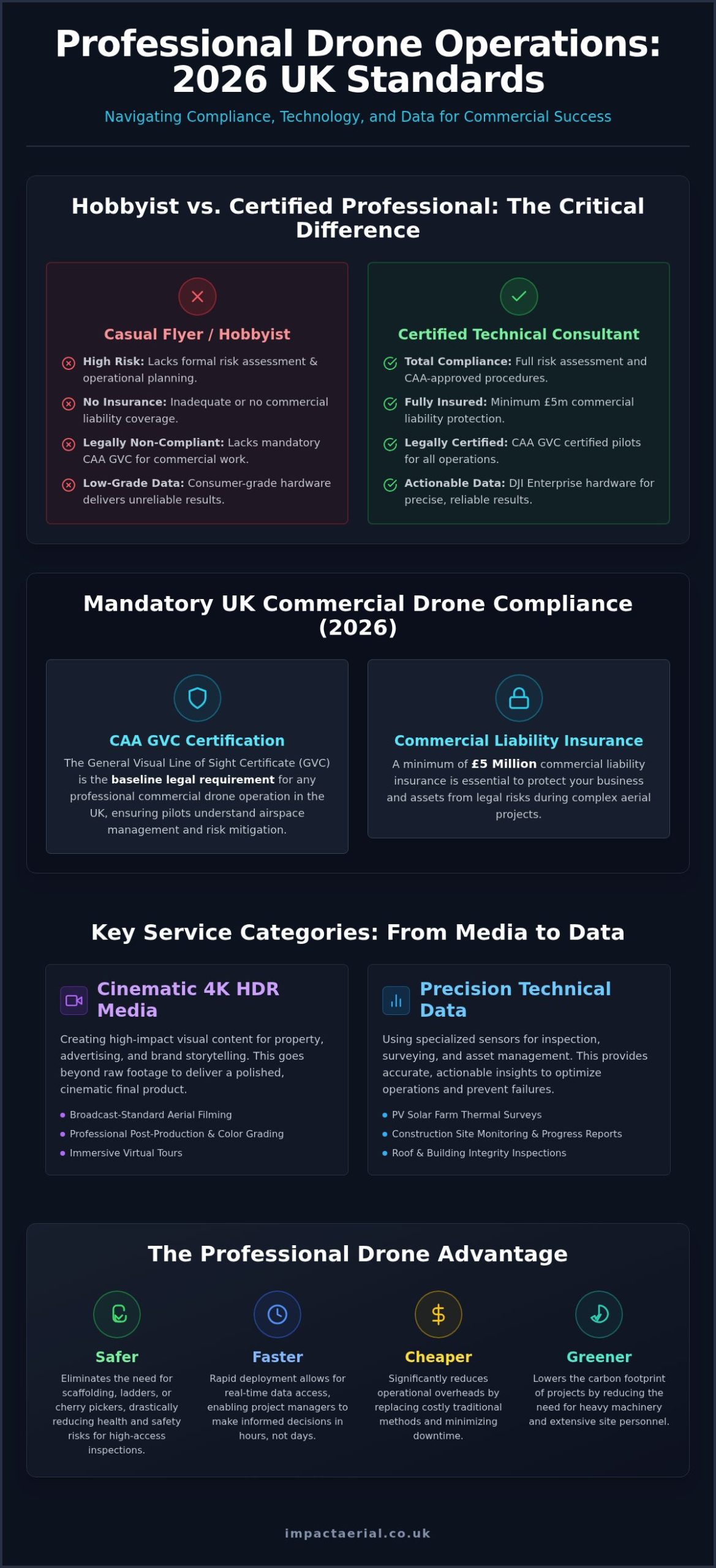
In 2026, the difference between a hobbyist with a camera and a certified technical consultant isn’t just about the hardware; it’s about the legal and financial security of your entire operation. You likely know that aerial data, such as PV solar farm thermal surveys UK, can radically improve your asset management, yet the fear of CAA non-compliance or receiving low-grade data often stalls the decision to hire. It’s difficult to distinguish between a casual flyer and a specialist who understands the nuances of professional standards and risk mitigation.

This guide ensures you can leverage professional drone technology for cinematic 4K HDR media and precise technical data collection while maintaining total regulatory compliance. We’ll show you how to secure accurate, actionable results through a hassle-free, fully insured flight operation. We’ll break down the latest 2026 UK class markings, the necessity of CAA GVC certification, and the specific DJI Enterprise hardware required to deliver the industry-leading quality your business demands.

Key Takeaways

  • Understand the mandatory legal requirements for 2026, including why CAA GVC certification is the baseline for any professional commercial drone operation in the UK.
  • Learn how to use high-resolution PV solar farm thermal surveys UK to identify anomalies and optimize energy output through accurate, actionable data collection.
  • Discover the operational workflow for construction site monitoring and property surveys that prioritizes site safety and comprehensive risk assessments.
  • Evaluate the benefits of integrating 4K HDR aerial filming with post-production services to create high-impact visual content for the property and advertising sectors.
  • Identify the essential insurance benchmarks, such as £5m commercial liability, required to protect your business from legal risks during complex aerial projects.

The Evolution of Professional Drone Services in the UK

Professional drone services have transitioned from being viewed as high-tech novelties to becoming critical infrastructure tools for UK businesses. Today, an Unmanned aerial vehicle is no longer just a flying camera; it’s a sophisticated data collection platform. These integrated solutions provide a bridge between cinematic media and technical datasets, offering insights that were previously cost-prohibitive or physically impossible to obtain. As we enter 2026, the industry is defined by a “Safer, Faster, Cheaper, Greener” framework. By replacing traditional methods with aerial technology, companies significantly reduce their carbon footprint and operational overheads while improving safety standards across the board.

Under the 2026 regulatory landscape, the Civil Aviation Authority (CAA) has tightened the standards for commercial operators. Simply owning a drone is not enough for complex industrial work. Professional services now require GVC (General Visual Line of Sight Certificate) certified pilots who understand the nuances of risk assessment and airspace management. This ensures that every flight is not only productive but fully compliant and insured, providing the reassurance that your business is protected from legal liability.

The Business Case for Aerial Integration

The most immediate benefit of drone adoption is the mitigation of health and safety risks. By utilizing drones for roof inspections or tall structure assessments, you eliminate the need for scaffolding, cherry pickers, or ladders. This doesn’t just save money; it protects your workforce. Rapid deployment allows for real-time data access, meaning project managers can make informed decisions in hours rather than days. We provide unique perspectives that ground-based teams simply cannot replicate, ensuring every angle of a site is documented with 4K HDR precision.

Commercial Applications Across UK Industries

UK industries are increasingly reliant on these specialized services to maintain a competitive edge. In property and real estate, high-impact visuals are standard for marketing, while construction firms use drones for site monitoring and structural integrity checks. The renewable energy sector has seen a significant shift toward data-driven maintenance. Specialized PV solar farm thermal surveys UK are now a requirement for efficient asset management. These surveys use high-resolution thermal sensors to detect cell defects or “hot spots” that are invisible to the naked eye. By identifying these issues early, operators can prevent failures and maximize energy yield across the grid. This technical approach transforms a simple flight into a vital maintenance strategy.

From Cinematic Media to Technical Data: Key Service Categories

Professional drone operations in 2026 are categorized by their output: either high-fidelity creative content or precision technical data. While hobbyists might focus on a single shot, a professional operator integrates hardware like DJI Enterprise drones to deliver multi-layered results. This includes everything from immersive virtual tours for commercial galleries to specialized industrial inspections. The shift toward data-centric services means that aerial platforms are now essential for maintaining large-scale infrastructure and high-value property assets.

Professional Aerial Videography and Post-Production

High-quality marketing requires more than raw footage. Using an aerial filming drone with 4K HDR sensors ensures every frame meets broadcast standards. The true value lies in the post-production phase. Professional editing turns raw clips into a cinematic brand story through expert color grading and pacing. This is essential for property developers and agencies who need to showcase the scale and quality of their projects with total clarity.

Precision Drone Surveying and Data Collection

Data-centric applications have revolutionized building maintenance and infrastructure management. A professional drone survey allows for comprehensive roof and building inspections without the safety risks or costs associated with high-access equipment like scaffolding or cherry pickers. For the renewable energy sector, this technology is indispensable. Implementing PV solar farm thermal surveys UK allows operators to identify defective cells or bypass diode failures that compromise energy output.

According to guidelines on PV system maintenance, early detection of thermal anomalies is critical for maximizing the lifecycle and ROI of solar assets. These specialized PV solar farm thermal surveys UK use radiometric sensors to provide precise temperature data across thousands of panels in a single flight. This technical consultancy approach ensures that maintenance teams can target specific repairs rather than conducting manual, time-consuming inspections across the entire site. If you’re looking to protect your infrastructure investments, it’s wise to consult with a technical drone specialist to discuss your specific data requirements.

Beyond technical data, immersive virtual tours offer an interactive experience by combining aerial perspectives with ground-based content. This holistic approach is particularly effective for large-scale commercial real estate and tourist attractions. It allows potential clients or visitors to explore a site remotely with a level of detail that traditional photography cannot match. By integrating these diverse service categories, businesses can secure both the marketing assets and the technical data they need to thrive in a competitive market.
Professional Drone Services in the UK: The 2026 Buyer’s Guide

Understanding Compliance: Why CAA GVC Certification and Insurance Matter

Compliance is the non-negotiable foundation of any professional drone operation. By 2026, the UK Civil Aviation Authority (CAA) drone regulations have evolved to include mandatory Remote ID broadcasting for most commercial-grade aircraft. Any pilot conducting work for “valuable consideration” must hold a valid drone license. This ensures the operator has passed the necessary competency tests and is registered with the CAA. For technical applications like PV solar farm thermal surveys UK, operating without these credentials isn’t just a safety risk; it’s a significant legal liability for the client. Professional operators act as technical consultants, managing the complex paperwork and site-specific risk assessments so you don’t have to.

GVC vs. A2 CofC: What Clients Need to Know

It’s vital to distinguish between the A2 Certificate of Competency (A2 CofC) and the General Visual Line of Sight Certificate (GVC). While the A2 CofC is suitable for lightweight drones in open spaces, the GVC is the gold standard for industrial work. It requires a pilot to maintain a detailed Operations Manual and secure a PDRA01 Operational Authorisation from the CAA, which currently carries an annual fee of £524. This certification allows for much greater flexibility, especially for projects in congested areas or when using heavy DJI Enterprise hardware. Verifying these credentials before the first flight protects your project from being grounded by local authorities or failing a safety audit.

Insurance and Liability in Professional Operations

Risk mitigation extends beyond pilot skill to include robust financial protection. Hobbyist insurance policies are insufficient for commercial risks. Professional operators carry specialist liability cover that meets the requirements of EC 785/2004. While some freelancers carry minimal cover, £5m commercial liability insurance is the standard for reputable UK firms serving the construction and energy sectors. This level of insurance is essential when performing PV solar farm thermal surveys UK, where drones fly in close proximity to high-value assets. It covers third-party injury and property damage, ensuring that your business is fully insulated from financial loss. This meticulous approach to safety and regulation is what separates a professional service from a casual operator.

Planning Your Project: The Workflow of a Professional Drone Operation

A successful drone mission is built on a foundation of methodical planning and technical precision. It isn’t merely about launching an aircraft; it’s a structured workflow designed to deliver specific business outcomes. The process begins with an initial consultation where we define your project goals, required deliverables, and any site-specific constraints. For example, executing PV solar farm thermal surveys UK requires a different flight profile compared to a cinematic marketing shoot. We establish the technical parameters early to ensure the data collected is both accurate and actionable for your maintenance teams.

The Importance of Pre-Flight Risk Assessment

Meticulous pre-flight planning is the hallmark of a professional operator and a core requirement for CAA compliance. Before arriving on-site, we conduct a comprehensive site survey and risk assessment to identify potential hazards like overhead power lines, tall structures, or public access points. We also manage the complex task of checking airspace restrictions via NOTAMs (Notices to Air Missions). If your site is within a Flight Restriction Zone (FRZ) near an airport, we secure the necessary permissions from Air Traffic Control well in advance. Weather monitoring is equally critical; we track wind speeds and precipitation levels to ensure the operation can proceed safely without compromising the quality of the 4K HDR visuals or radiometric data.

On-site execution is handled by GVC certified pilots using specialized DJI Enterprise hardware. This equipment is designed for industrial reliability, allowing us to capture high-resolution imagery and precise thermal data even in challenging environments. This phase is characterized by a “safety-first” approach, where the pilot-in-command maintains constant situational awareness to protect your assets and personnel throughout the flight duration.

Post-Production and Deliverable Formats

The final phase involves transforming raw captures into professional-grade assets that drive value for your business. For marketing-focused drone photography, post-production is where we apply color correction and retouching to ensure the visuals align with your brand identity. Technical projects, such as PV solar farm thermal surveys UK, require specialized software analysis to produce orthomosaic maps or detailed thermal reports that highlight specific panel anomalies. Delivery timelines typically range from 24 to 72 hours depending on the complexity of the data processing required. If you’re ready to start your project with a compliant and expert team, you can book your professional drone consultation today to discuss your specific requirements.

Why Partner with Impact Aerial for Your UK Drone Requirements

Impact Aerial stands at the intersection of creative excellence and technical precision. We provide a comprehensive suite of professional services that bridge the gap between high-end cinematography and industrial data collection. As a technical consultant, we don’t just fly; we manage the entire lifecycle of your project. This includes everything from the initial brief to the final delivery of broadcast-quality media or actionable technical reports. Our commitment to the highest safety standards is evidenced by our CAA GVC certification and £5m commercial liability insurance, providing the reassurance you need when operating near high-value assets.

West Midlands Roots, Nationwide Reach

Based in Birmingham, we leverage our regional knowledge of the West Midlands while maintaining the logistical capability for nationwide deployment. Providing consistent drone services across the UK requires a meticulous approach to travel planning, local airspace permissions, and risk management. We’ve successfully delivered projects for the property, construction, and advertising sectors nationwide. This reach ensures that multi-site organizations receive a uniform standard of data and media quality across their entire portfolio, regardless of the specific location.

Our Technology and Post-Production Edge

We utilize the latest DJI Enterprise hardware to ensure superior flight stability and image resolution. This equipment is specifically designed for the rigors of industrial work, making it the ideal platform for PV solar farm thermal surveys UK. However, the Impact Aerial difference lies in our post-production capabilities. While many operators simply hand over raw files, we provide full post-production editing as part of our service. This turns raw 4K HDR footage into compelling brand stories and transforms complex radiometric data into clear, prioritized maintenance schedules.

Our client-centric approach focuses on reliability and precision. When conducting PV solar farm thermal surveys UK, we understand that your ROI depends on the accuracy of our findings. By combining high-end sensors with expert data analysis, we identify defects that others might miss. This meticulous attention to detail ensures your project is completed on time and to the highest professional standards. We act as your trusted specialist, allowing you to focus on your core business while we handle the complexities of the aerial environment.

Securing Your Competitive Edge with Professional Aerial Solutions

Choosing a drone partner in 2026 is a strategic decision that impacts both operational safety and the quality of your business data. We’ve explored how the transition to professional standards requires more than just high-end hardware; it demands a meticulous approach to CAA GVC certification and comprehensive risk management. Whether you’re looking to enhance your marketing with 4K HDR media or require technical PV solar farm thermal surveys UK to protect your infrastructure, the focus must always remain on precision and legal compliance.

Impact Aerial provides the reassurance of CAA GVC Certified Pilots and £5m commercial liability insurance, ensuring your project is handled by technical consultants rather than just operators. Our expert post-production services turn raw data into actionable insights and cinematic stories that drive results. You can Request a Professional Drone Service Quote from Impact Aerial today to discuss your specific site requirements. We look forward to helping you leverage the full potential of professional drone technology for your next project.

Frequently Asked Questions

Do I need a special license to hire a drone service in the UK?

You don’t need a personal license to hire a service, but the operator you contract must hold a valid UK Civil Aviation Authority (CAA) commercial authorization. For most professional work in 2026, this means hiring a pilot with a General Visual Line of Sight Certificate (GVC). This certification ensures the pilot is trained in complex risk assessments and maintains a formal Operations Manual, protecting your business from legal liability during aerial projects.

What is the difference between a professional drone pilot and a hobbyist?

The primary differences lie in regulatory compliance, insurance, and technical hardware. Professional pilots hold GVC certification and carry commercial-grade liability insurance, whereas hobbyists typically lack these legal protections. Professionals use DJI Enterprise drones capable of capturing specialized data, such as PV solar farm thermal surveys UK. They act as technical consultants who understand airspace management and post-production, rather than individuals simply capturing casual imagery without a structured safety framework.

How much does it cost to hire professional drone services?

Costs for professional drone services vary based on the project’s complexity, location, and the specific hardware required. Factors such as the need for specialized thermal sensors or extensive post-production editing will influence the final quote. While we don’t provide fixed price lists, a professional service includes the cost of CAA compliance, £5m liability insurance, and expert data analysis. It’s best to request a tailored consultation to define your specific deliverables and site constraints.

Can drones fly in rain or high winds?

Most professional drones shouldn’t fly in heavy rain or winds exceeding 20 to 25mph, though some Enterprise models have higher weather resistance ratings. Safety is the priority; high winds can destabilize the gimbal, affecting the quality of 4K HDR visuals or technical data. We monitor weather patterns closely in the days leading up to a shoot. If conditions are unsafe, we reschedule the flight to ensure the integrity of your data and the safety of the aircraft.

Are there restrictions on where drones can fly in UK cities?

Yes, there are significant restrictions on flying drones in UK cities, particularly within Flight Restriction Zones (FRZs) near airports. Professional operators must secure specific permissions from Air Traffic Control and the CAA when flying in congested areas. We handle all airspace authorizations and local council notifications as part of our project management. This meticulous planning ensures that your urban construction monitoring or property filming stays fully compliant with the latest 2026 aviation laws.

How long does a typical drone survey or filming session take?

A typical session ranges from a few hours for a property survey to several days for large-scale industrial sites. The duration depends on the total area and the density of data required. Conducting PV solar farm thermal surveys UK involves methodical flight paths to capture every panel with radiometric precision. We provide a detailed timeline during the initial consultation so you know exactly how long the on-site execution and subsequent data processing will take.

What insurance coverage should a professional drone company have?

A professional drone company must have specialist commercial liability insurance that complies with EC 785/2004 regulations. Standard hobbyist or public liability policies often exclude aviation risks, leaving you vulnerable. We carry £5m in commercial liability insurance as an industry standard for high-value sectors like construction and energy. This coverage protects your business against third-party injury or property damage, providing essential reassurance and financial security throughout the duration of the flight operation.

What deliverables will I receive after a drone survey?

Deliverables are tailored to your project goals and can include raw 4K HDR footage, edited cinematic videos, or high-resolution orthomosaic maps. For technical inspections like PV solar farm thermal surveys UK, you’ll receive detailed reports and annotated imagery highlighting specific anomalies. We also provide full post-production services, ensuring your marketing content is polished and your technical data is actionable. All files are typically delivered via a secure digital link within 24 to 72 hours after the flight.
Insured Drone Operator UK: A Complete Guide to Hiring Safely

What happens if a drone crashes into your property? Who is liable if someone is injured during filming? These are not hypothetical scenarios; they are critical risks that can expose your business to significant financial and legal damage. This is precisely why engaging a fully insured drone operator uk is not just a best practice-it’s an essential safeguard for your project, your reputation, and your finances. Hiring an operator based on a low price alone could end up costing you thousands in unforeseen damages and liability claims.

But how can you be certain an operator’s insurance is legitimate and sufficient for your specific needs? Navigating the complexities of commercial liability, aviation regulations, and policy verification can be a daunting task. This comprehensive guide is designed to provide you with complete peace of mind. We will break down exactly what to look for, the key questions you must ask, and how to confidently verify that you are partnering with a truly professional and compliant operator, protecting your business from risk and ensuring a safe, successful project from start to finish.

Key Takeaways

  • Understand that if you hire an uninsured operator, your business becomes legally and financially liable for any accidents, property damage, or injuries.
  • Learn the critical difference between basic recreational cover and the robust commercial liability insurance required for any professional drone work in the UK.
  • Discover the specific documents and CAA certifications you must request to confidently verify you are hiring a fully compliant and insured drone operator uk.
  • Recognise that comprehensive insurance is the foundation, not the ceiling, of a professional service that prioritises a deep culture of safety and operational excellence.

What ‘Insured Drone Operator’ Means for Your Project’s Safety

When you hire a professional for aerial work, the term ‘insured drone operator’ is more than just a reassuring buzzword; it’s a critical component of your project’s financial and legal security. It signifies that the operator holds a specialised commercial insurance policy designed specifically for aviation activities. This is a non-negotiable legal requirement for any commercial drone work in the UK, providing a vital safety net against unforeseen accidents. Without it, you, the client, could be exposed to significant liability.

To better understand the specifics of this coverage, this short guide provides a clear overview:

Commercial vs. Hobbyist Insurance: A Critical Distinction

A fundamental mistake is assuming any drone insurance will suffice. Hobbyist or recreational policies are designed purely for personal use and are immediately voided if the drone is flown for ‘hire and reward’. A professional, insured drone operator in the UK must carry a commercial policy that explicitly covers business activities. Hiring an operator with the wrong insurance is the same as hiring one with no insurance at all, leaving your project completely unprotected.

Key Coverage Types Explained Simply

Commercial drone insurance is not a single product but a package of protections. The most important one for you as a client is:

  • Public Liability Insurance (PLI): This is the cornerstone of commercial drone operations. It covers costs associated with injury to third parties or damage to their property. All commercial operators must hold PLI compliant with EC 785/2004, a standard mandated by the comprehensive UK drone regulations.
  • Equipment Insurance: This covers the drone, cameras, and other gear. While this is primarily the operator’s risk, it ensures they can continue work in the event of equipment failure.
  • Cyber & Data Liability: An increasingly vital cover for projects involving sensitive data capture, such as site surveys or infrastructure inspections.

Why Your Own Insurance Won’t Cover Drone Incidents

It is a dangerous assumption that your company’s general business or public liability insurance will cover an incident involving a drone. The vast majority of standard commercial policies contain specific exclusions for aviation activities and unmanned aircraft. Attempting to claim on your own policy would almost certainly result in denial, leaving your business liable for all costs. By hiring a properly insured drone operator, you correctly transfer this specialised risk to their insurer, providing essential peace of mind.

The Real Risks: What Happens When You Hire an Uninsured Operator?

While professional drone operations are meticulously planned to be safe, the potential for accidents due to technical malfunction or unforeseen environmental factors can never be completely eliminated. Choosing an uninsured operator transfers the enormous financial and legal risk directly onto you and your business. The savings of a cheaper, non-compliant quote are insignificant compared to the catastrophic costs of a single incident.

Understanding these real-world consequences is crucial for any business looking to leverage aerial data. Let’s explore what is truly at stake.

Scenario 1: Property Damage During a Survey

Imagine you have commissioned a drone to survey a commercial building’s roof. Mid-flight, the drone loses signal and collides with the building, damaging expensive cladding and smashing a series of high-level windows. Without operator insurance, the liability for the repair costs-potentially running into tens of thousands of pounds-falls directly on you as the client. A certified and insured drone operator uk carries robust Public Liability Insurance (PLI) specifically to cover these events, protecting your assets and ensuring repairs are handled without any financial impact on your business.

Scenario 2: Third-Party Injury at a Public Event

Consider a drone being used to film your corporate event or a local festival. If the aircraft fails and falls into a crowd, the consequences escalate from property damage to severe personal injury. This opens your business up to significant personal injury claims, protracted legal battles, and compensation awards that can be financially crippling. The subsequent negative press can also cause irreparable damage to your brand’s reputation. When the operator is uninsured, it is often the client who hired them that faces the full force of legal action.

Who is Legally Liable? The ‘Hirer Beware’ Principle

In the UK, the responsibility for ensuring a drone operation is compliant does not rest solely with the pilot. By engaging a non-compliant operator, you, the client, assume a significant portion of the risk. Failing to perform due diligence and verify that your chosen provider meets the legal Civil Aviation Authority insurance requirements can be viewed as negligence. In the event of a serious incident, the CAA may investigate your hiring process as well as the operator’s actions. This principle of ‘hirer beware’ underscores why working with a professional, fully insured drone operator in the UK is an non-negotiable part of project risk management.

Ensure your project is protected. Speak to our insured experts.

Decoding Drone Insurance in the UK: A Checklist for Clients

Verifying an operator’s insurance is more than just ticking a box; it’s a critical step in your due diligence process. A professional operator will readily provide their insurance certificate, but knowing what to look for is essential for your protection. To ensure you partner with a genuinely insured drone operator uk, use this checklist to assess their documentation and confirm their coverage is both valid and appropriate for your project.

Public Liability Limits: Is £1 Million Enough?

While the minimum Public Liability Insurance (PLI) for commercial drone operations is set at approximately £1 million, this level is rarely sufficient for professional, industrial, or commercial projects. For added peace of mind and comprehensive protection, the industry standard for high-value work, such as on construction sites, for asset inspections, or near public spaces, is typically £5 million or £10 million. Always ensure the operator’s cover limit matches the potential risks of your specific project.

What is EC 785/2004 Aviation Compliance?

This is the most critical detail to find on an insurance certificate. EC 785/2004 is a specific aviation regulation, adopted by the UK, that governs insurance for air carriers and aircraft operators. Standard public liability policies do not cover aviation activities. Any policy that is not compliant with this regulation is invalid for commercial drone work. This isn’t just a recommendation; it’s a legal mandate outlined in the official Civil Aviation Authority insurance requirements. The presence of this clause is a key indicator of a specialist, legitimate policy.

Checking the Policy’s Fine Print: What to Look For

When you receive an insurance certificate, don’t just file it away. Take a moment to perform these simple but vital checks. An authentic insured drone operator uk will have a policy that clearly states the following:

  • The Insured’s Name: Does the company or individual name on the policy match the operator you are hiring? Discrepancies here are a major red flag.
  • Policy Dates: Check the “effective from” and “expiry” dates to confirm the policy is current and will be valid for the entire duration of your project.
  • Coverage Level: Verify that the stated Public Liability limit meets your project’s requirements (e.g., £5 million or £10 million).
  • Aviation Compliance: Look for explicit mention of “EC 785/2004” to confirm it is a valid aviation-specific policy.

How to Confidently Verify an Operator’s Credentials

Understanding the importance of insurance is the first step; verifying it is the crucial next one. A truly professional and compliant operator will be transparent and readily provide documentation for your peace of mind. This practical guide will empower you to confidently assess an operator’s credentials before any work begins, ensuring you hire a legitimate insured drone operator UK businesses can rely on.

Step 1: Ask for the Certificate of Commercial Insurance

Any legitimate drone company will provide their Certificate of Commercial Insurance without hesitation. When you receive the document, take a moment to review the key details. First, ensure the business name on the policy matches the company you are hiring and cross-reference it with their website. Check that the policy is current and has not expired. Most importantly, the policy must explicitly cover commercial operations using ‘Unmanned Aerial Vehicles’ (UAVs), ‘Unmanned Aircraft Systems’ (UAS), or ‘Drones’.

Step 2: Request the CAA Operational Authorisation

Alongside insurance, the operator must hold a valid Operational Authorisation from the UK’s Civil Aviation Authority (CAA). This is the official legal permission required to conduct commercial drone flights, and it is a critical piece of the compliance puzzle. In fact, most specialist insurance policies are rendered invalid if the operator does not hold this authorisation. The document will clearly state the registered operator’s name and their unique CAA authorisation number.

Red Flags to Watch Out For

Your due diligence protects your project, your property, and your reputation. Be alert for these common warning signs that suggest an operator may not be compliant or properly insured:

  • Reluctance to Provide Documents: A professional will have their insurance and CAA authorisation ready. Hesitancy or outright refusal is a major red flag.
  • Unusually Low Prices: Professional insurance, equipment, and certification are significant business costs. A quote that is dramatically lower than others may indicate these essential overheads have been skipped.
  • Vague or Evasive Answers: Questions about insurance limits, CAA status, or safety procedures should be met with clear, confident answers.
  • Lack of Professional Presence: A missing or unprofessional website, no registered company details, or a lack of a portfolio can suggest a hobbyist rather than a certified commercial professional.

By following these steps, you ensure you are partnering with a credible and fully insured drone operator. At Impact Aerial, we pride ourselves on transparency and are always prepared to provide our full documentation for client review.

Beyond Insurance: Hallmarks of a Truly Professional Drone Service

While comprehensive commercial insurance is the non-negotiable foundation for any drone operation, it represents the baseline, not the complete picture of professionalism. A truly reliable and safe service is built upon a much broader culture of safety, compliance, and operational excellence. Choosing a properly insured drone operator uk is the first step; verifying their qualifications, planning procedures, and experience is what guarantees a successful and risk-free project.

These additional hallmarks are what separate a true specialist from a simple hobbyist with a policy. They demonstrate a deep-seated commitment to not only protecting your interests financially, but to proactively preventing incidents from ever occurring.

CAA GVC Certification: The Pilot’s Licence

In the UK, the key pilot qualification is the General Visual Line of Sight Certificate (GVC). This certification is a prerequisite for any operator applying to the Civil Aviation Authority (CAA) for an Operational Authorisation, which is required for most commercial work. Hiring a GVC-certified pilot provides assurance that they have been rigorously trained and tested on UK air law, flight planning, and critical safety procedures, ensuring a high standard of operational competence.

The Importance of Risk Assessments (RAMS)

A professional operator never arrives on-site and simply launches their drone. Every commercial flight is preceded by meticulous planning, including a detailed site survey and the creation of a Risk Assessment and Method Statement (RAMS). This crucial process involves:

  • Identifying all potential on-site hazards (e.g., public access, power lines, buildings, air traffic).
  • Assessing the level of risk associated with each hazard.
  • Defining clear, actionable steps to mitigate those risks and ensure a safe flight.

For complete peace of mind, you should always feel confident asking a potential operator to share an example of their RAMS documentation.

Why Experience Matters

A certificate proves theoretical knowledge, but only real-world experience builds true expertise. An experienced operator has the practical skills to manage dynamic situations, adapt to unexpected challenges like sudden weather changes, and understand the unique complexities of different environments, from busy construction sites to sensitive ecological surveys. This background ensures not only safety but also greater efficiency and higher-quality data collection. An experienced, insured drone operator uk transforms a potential risk into a reliable asset for your project.

These elements-robust insurance, official certification, meticulous planning, and deep industry knowledge-are what define a professional partner you can trust. Our team combines £5m insurance with years of industry experience, providing the comprehensive peace of mind your project deserves.

Your Final Check: Partnering with a Vetted and Insured Drone Operator

Hiring a drone operator in the UK is a decision that carries significant weight for your project’s safety and success. As we’ve explored, the distinction between a professional and an amateur lies in verifiable credentials. The key takeaways are clear: comprehensive insurance is non-negotiable for mitigating risk, and diligent verification of an operator’s CAA certification and policy documents is essential due diligence. Ultimately, selecting the right insured drone operator uk is about securing more than just aerial footage-it’s about ensuring compliance, safety, and total peace of mind.

At Impact Aerial, we provide this assurance as standard. Our pilots are all CAA GVC Certified and backed by £5m in Commercial Liability Insurance, offering professional services with nationwide UK coverage. Don’t leave your project’s outcome to chance. Protect your project. Request a quote from our fully insured and CAA-certified team today. Make the safe, professional choice and let’s achieve breath-taking results together.

Frequently Asked Questions

Is drone insurance a legal requirement for commercial operators in the UK?

Yes, it is an absolute legal requirement. Any individual or company operating a drone for commercial purposes in the UK must hold valid commercial drone insurance that complies with the EC 785/2004 regulation. This is not optional and applies to all commercial flights, regardless of the drone’s size or weight. Operating without this specific aviation insurance is illegal and carries significant penalties, highlighting the importance of verifying your chosen operator’s credentials before any work commences.

What is the minimum level of public liability insurance a drone operator must have?

The minimum level of public liability insurance is dictated by the regulation EC 785/2004 and is based on the aircraft’s weight. For most commercial drones, the legal minimum is 750,000 Special Drawing Rights, which equates to approximately £750,000. However, most professional operators carry significantly higher levels of cover, often between £5 million and £10 million, to provide comprehensive protection and peace of mind for their clients, especially when working on large-scale industrial or commercial sites.

What happens if I hire an uninsured drone pilot and there is an accident on my property?

Hiring an uninsured operator exposes you and your business to significant financial and legal risk. If an accident occurs causing property damage or personal injury, the liability could fall directly onto you as the client who commissioned the work. Without an appropriate insurance policy to claim against, you could be held personally or corporately responsible for covering all associated costs, from repairs to substantial personal injury claims. This is a primary reason to only work with a fully insured drone operator UK.

How is a drone operator’s insurance different from a photographer’s public liability insurance?

The distinction is critical. Standard public liability insurance, such as that held by a ground-based photographer, explicitly excludes aviation activities. Drone operations require a specialist aviation insurance policy that is compliant with EC 785/2004. This covers specific risks associated with flying an aircraft, including injury or damage caused by the drone itself. A photographer’s policy offers no protection for incidents involving an unmanned aircraft, making it entirely unsuitable and non-compliant for commercial drone work.

Can I check an operator’s CAA status online?

While the Civil Aviation Authority (CAA) does not have a public-facing database for instantly verifying an operator’s specific permissions, you can and should take direct steps. Always ask the operator to provide a copy of their Operational Authorisation certificate, which contains their Operator ID and outlines the scope of their permitted operations. A professional and legitimate operator will readily provide this documentation for your verification and peace of mind before commencing any project.

Does Impact Aerial operate with full commercial drone insurance?

Yes, absolutely. Impact Aerial operates with comprehensive commercial drone insurance that exceeds the minimum legal requirements set by the CAA. For our clients’ complete peace of mind, we hold a £10 million public liability policy, ensuring full compliance and protection for every project we undertake. We believe in absolute transparency and are happy to provide our insurance documentation and CAA Operational Authorisation certificate upon request, confirming you are working with a safe and professional insured drone operator UK.

Professional Sky Services: The Ultimate Guide to Drones in Business

The world of commercial drones offers incredible opportunities, yet navigating this new landscape can be daunting for any business. You may be wondering what’s truly possible, how to distinguish between cinematic filming and technical surveys, or-most importantly-how to ensure you’re hiring a safe and legally compliant operator. Understanding the full spectrum of professional sky services is the first step towards leveraging this technology effectively. It’s not just about flying a drone; it’s about deploying a powerful tool for data collection, marketing, and operational efficiency with complete confidence.

In this ultimate guide, we demystify the industry for you. We will break down the key categories of professional drone services, from breathtaking aerial videography to precision-based 3D modelling and structural inspections. You will learn how to identify the right service for your specific project, understand the critical importance of CAA GVC certification and commercial liability insurance, and gain the confidence to select a provider that offers not just top-quality results, but complete peace of mind. Discover how to unlock the cost savings, improved safety, and superior data that professional drone operations can bring to your business.

Defining Sky Services: A Modern Perspective on Aerial Operations

When we discuss professional sky services, we are referring to a sophisticated range of commercial operations conducted using advanced drone technology. It’s important to clarify that this is entirely distinct from the telecommunications and media company, Sky Group Ltd. Our focus is on leveraging the capabilities of the modern Unmanned Aerial Vehicle (UAV) to capture high-resolution data and imagery from the air. This technology forms the backbone of a new era in aerial work, offering precision, safety, and efficiency that was once unimaginable.

To see these services in action, the video below offers a glimpse into the world of professional drone operations:

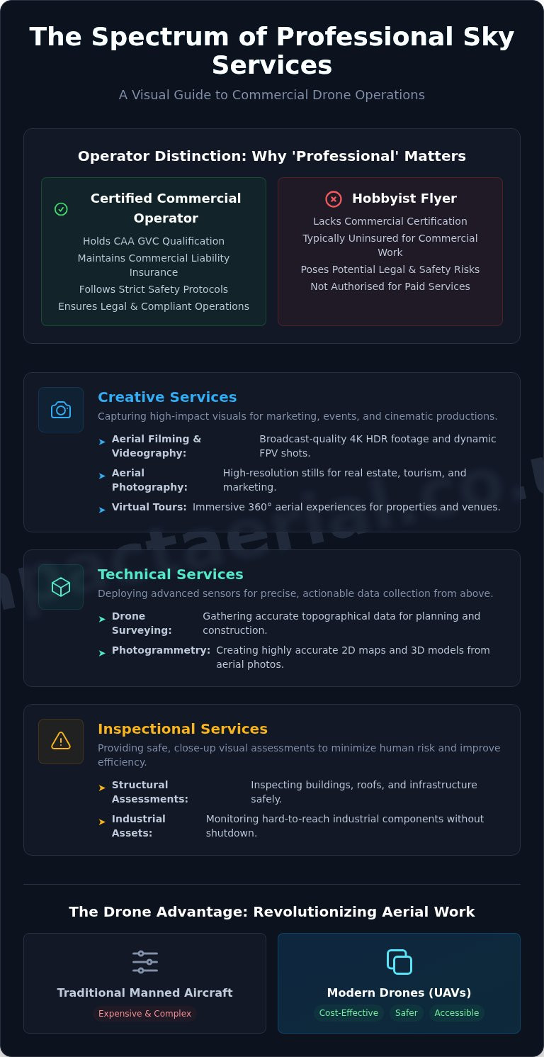
These services can be broadly categorised into three main areas. Creative services include cinematic aerial filming and photography for marketing and events. Technical services involve precise data-gathering for applications like photogrammetry and 3D modelling. Finally, inspectional services provide safe, close-up visual assessments of buildings, infrastructure, and industrial assets, minimising risk to human life.

The Evolution from Manned Aircraft to Drones

Historically, aerial data capture required the use of expensive and logistically complex manned aircraft like helicopters or planes. Drones have revolutionised this landscape by offering a safer, more accessible, and highly cost-effective alternative. This shift has democratised access to top-quality aerial perspectives, enabling businesses of all sizes to benefit from data and visuals that were previously reserved for large-scale productions or major civil engineering projects.

Why ‘Professional’ Matters: Hobbyist vs. Commercial Operator

The distinction between a hobbyist flyer and a certified commercial operator is critical. Professional sky services are governed by strict regulations set by the UK’s Civil Aviation Authority (CAA). A commercial operator must hold a GVC (General Visual Line of Sight Certificate), undergo rigorous training, and maintain comprehensive commercial liability insurance. This framework ensures that all operations are conducted safely and legally, providing clients with the essential peace of mind that their project is in expert hands.

Creative Sky Services: Capturing High-Impact Visuals

Beyond technical inspections and surveys, our professional sky services offer transformative creative potential for businesses across the UK. Drones provide a unique vantage point, capturing high-impact visuals that were once prohibitively expensive or simply impossible. While aerial photography captures stunning, high-resolution still images to provide context, aerial videography brings these perspectives to life with dynamic motion. Adherence to strict operational standards, such as those mandated by the UK’s Civil Aviation Authority (CAA), is paramount for any creative flight. Understanding the global regulatory landscape, including the comprehensive FAA regulations for commercial drones in the US, further highlights why choosing a certified, knowledgeable operator is crucial for project success and safety.

Aerial Filming & Videography

Our creative sky services deliver broadcast-quality footage for promotional videos, television, and cinematic productions. Utilising the latest 4K HDR cameras, we produce crystal-clear, vibrant visuals that command attention. For dynamic sequences, we deploy cinematic FPV (First Person View) drones to fly through structures and follow moving subjects with unparalleled agility. This technology enables breath-taking shots that immerse the viewer in the action. Every project benefits from professional post-production, including colour grading and editing, to ensure a polished final cut.

To see how we bring cinematic vision to life, explore our dedicated Aerial Filming services.

Aerial Photography for Business

For industries like commercial real estate, tourism, and event management, a single aerial photograph can convey more than a dozen ground-level shots. Our high-resolution images showcase properties in their entirety, highlighting key features, boundaries, and surrounding amenities. This elevated perspective provides essential context and a sense of scale, giving potential buyers or visitors a complete and compelling overview. These visuals are invaluable assets for marketing brochures, websites, and planning documents.

View examples of our work in our Drone Photography portfolio.

Virtual Tours and Immersive Experiences

We elevate property and venue marketing by creating fully interactive 360-degree virtual tours from the air. By capturing a series of panoramic images, we stitch together an immersive digital experience that allows users to explore a location from a unique aerial viewpoint. This technology is particularly effective for construction site progress monitoring, hospitality showcases, and large-scale property listings, offering stakeholders a detailed and engaging way to interact with a site from anywhere in the world.

Technical Sky Services: Precision Data from Above

Beyond capturing stunning visuals, our drones are sophisticated data-gathering platforms. We deploy advanced sensor technology to provide industries with precise, actionable intelligence from an aerial perspective. These technical sky services transform how businesses approach surveying, asset management, and safety compliance, delivering significant gains in both efficiency and accuracy across sectors like construction, energy, and infrastructure management.

Drone Surveying and Photogrammetry

Photogrammetry is the science of creating highly accurate 3D models and maps from overlapping aerial photographs. Our CAA-certified pilots conduct meticulous flights to capture data that is then processed into valuable outputs. This includes detailed orthomosaic maps for site planning, digital elevation models (DEMs) for terrain analysis, and precise stockpile volume calculations for the construction and quarrying industries, eliminating hazardous and time-consuming manual measurements.

Aerial Inspections for Safety and Maintenance

The foremost benefit of using drones for asset inspection is the dramatic improvement in safety. By deploying unmanned aerial vehicles (UAVs), we remove the need for personnel to work at height, operate near live electrical components, or access structurally compromised areas. Our services cover detailed inspections of:

  • Building facades and roofing systems
  • Telecommunication towers and wind turbines
  • Bridges, railways, and other critical infrastructure

This remote approach not only mitigates risk but also minimises operational downtime and reduces costs associated with scaffolding or rope access teams.

Specialised Surveys: Thermal and Agricultural

Equipped with radiometric thermal cameras, our drones can detect temperature variations invisible to the naked eye. This capability is invaluable for solar farm inspections, quickly identifying malfunctioning panels, and for conducting building heat loss surveys to improve energy efficiency. In agriculture, multispectral sensors allow us to monitor crop health, identify irrigation issues, and help farmers optimise yields with targeted interventions.

Our commitment to delivering top-quality data is underpinned by a rigorous adherence to operational standards. This professional approach is a global benchmark; just as commercial operators in the United States must follow strict FAA Part 107 Guidelines, our operations are fully compliant with UK Civil Aviation Authority regulations. To learn more about how our detailed data can benefit your project, explore our Commercial Drone Surveys.

Professional Sky Services: The Ultimate Guide to Drones in Business

Choosing a Sky Services Provider: A Checklist for Success

In a niche but increasingly diverse market, selecting the right drone operator is paramount to the success and safety of your project. Commissioning illegal or unqualified pilots exposes your business to significant liability and risk. This straightforward checklist provides the essential criteria for vetting a professional provider, ensuring your chosen partner for sky services operates with the highest standards of safety, legality, and technical expertise.

Essential Legal & Safety Requirements

Before discussing project specifics, a provider must meet these non-negotiable legal and safety benchmarks. Failure to produce any of this documentation is an immediate red flag.

  • CAA GVC Certification: The pilot must hold a valid General Visual Line of Sight Certificate (GVC) issued by the Civil Aviation Authority (CAA). This is the current UK legal requirement for most commercial drone operations and proves the pilot is trained in safe flight procedures. For more detail, you can review the official UK Drone Laws.
  • Commercial Drone Insurance: For your peace of mind, verify they hold specialist commercial drone insurance with a minimum of £5 million in public liability coverage. Ask to see a current certificate of insurance.
  • Risk Assessment Method Statements (RAMS): A professional operator will always conduct a thorough pre-flight survey and provide a detailed RAMS document. This is a clear sign of a meticulous and safety-conscious approach to every operation.

Evaluating Equipment and Expertise

Once legal compliance is established, you can assess if the company has the right tools and experience to deliver the high-quality results your project demands. A capable provider will be transparent about their technology and proud to showcase their work.

  • Professional Drone Fleet: Ask about the drones they use. A leading provider will operate a fleet of commercial-grade aircraft, such as the DJI Enterprise series, equipped for specific data-gathering tasks.
  • High-Quality Payloads: Enquire about camera quality (e.g., 4K HDR video) and whether they offer specialised sensors like thermal imaging for detailed inspections or LiDAR for advanced surveying.
  • Relevant Industry Experience: The most crucial step is to ask for a portfolio or case studies relevant to your sector. Proven experience in construction, surveying, or commercial property demonstrates they understand your specific challenges and can deliver breath-taking, actionable results.

Following this checklist will help you confidently select a competent and professional partner. For a complete overview of what to look for, see our guide on How to Hire a Drone Pilot. At Impact Aerial, we pride ourselves on transparency and exceeding industry standards. See our credentials and commitment to safety.

Partnering for Success: The Future of Your Aerial Strategy

As we’ve explored, the potential of drone technology is vast and transformative. From capturing breathtaking marketing visuals to gathering precise data for inspections and surveys, professional sky services offer a significant competitive advantage. The key to unlocking this potential lies not just in the technology itself, but in partnering with a provider who combines technical expertise with a deep commitment to safety and regulatory compliance.

At Impact Aerial, our experience across the Construction, Property, and Marketing sectors is backed by the highest industry standards. Our pilots are fully CAA GVC Certified and insured, providing you with complete peace of mind. By utilising state-of-the-art 4K HDR DJI Enterprise drones, we deliver top-quality, actionable insights tailored to your specific objectives.

Ready to see your project from a new perspective? Discuss your project with our certified aerial experts today. Take the first step towards elevating your business operations and achieving unparalleled results.

Frequently Asked Questions

What are the main types of professional sky services available?

Professional sky services encompass a wide range of data-gathering and media creation applications. Key services include high-resolution aerial photography and 4K videography for marketing and events. We also specialise in technical services like thermal imaging inspections for detecting heat loss, detailed roof and building surveys for maintenance, and advanced photogrammetry to create accurate 3D models and orthomosaic maps for construction and land management.

How much do professional drone services typically cost in the UK?

The cost of professional drone services in the UK varies based on project complexity, risk, and required deliverables. A straightforward half-day aerial photography project might start from £300-£500. However, more complex survey work requiring specialist equipment, extensive pre-flight planning, and detailed data processing will be quoted on a project-by-project basis. We always provide a detailed, transparent quote outlining all costs before any work commences.

What is the difference between a hobby drone pilot and a certified commercial operator?

The primary difference is legal and professional accountability. A certified commercial operator holds a CAA-issued Operational Authorisation (such as a GVC), undergoes rigorous training in flight safety and regulations, and carries comprehensive commercial liability insurance. Hobbyists operate under a different, more restrictive set of rules and cannot legally fly for commercial gain. Hiring a certified professional ensures your project is conducted safely, legally, and with complete peace of mind.

What industries benefit most from using sky services like drone surveys?

A diverse range of industries leverage professional sky services for efficiency and safety. The construction and engineering sectors use drone surveys for site monitoring and asset management. Estate agents and property developers benefit from compelling aerial marketing materials. Furthermore, building management and roofing companies rely on drones for safe, high-access inspections, while the agricultural sector uses them for crop health analysis and land mapping.

How do I verify if a drone company is legally certified by the CAA?

Any legitimate commercial drone operator in the UK must hold a valid Operational Authorisation issued by the Civil Aviation Authority (CAA). You should always ask to see a copy of this certificate before commissioning any work. For added assurance, you can also check for membership in professional bodies like the Drone Safe Register or ARPAS-UK, which vet their members to confirm they hold the correct certifications and insurance.

What kind of deliverables can I expect from an aerial filming or survey project?

Deliverables are tailored to your project’s specific goals. For creative projects, you can expect professionally edited, high-resolution 4K video clips and high-quality still photographs. For technical surveys and inspections, deliverables typically include detailed PDF reports with annotated imagery, orthomosaic maps, 3D point cloud data for use in CAD software, and digital elevation models (DEMs). We discuss all output formats with you during the initial consultation.

