In the densely packed urban corridors of the West Midlands, the difference between a stunning marketing asset and a significant legal liability often comes down to a single pilot’s certification. You’ve likely seen the potential of aerial perspectives to elevate your brand, but the complexity of 2026 UK drone regulations can make the process feel like a technical minefield. Whether you require high-end marketing footage or a precise drone building inspection birmingham wide, the stakes for safety and compliance have never been higher.
We understand that hiring a pilot shouldn’t feel like a gamble. This guide will demonstrate how professional Birmingham aerial videography integrates cinematic 4K HDR quality with rigorous CAA safety standards to provide total peace of mind. We’ll examine the latest UK0 to UK6 classification systems, the new Remote ID requirements, and how advanced DJI Enterprise technology delivers the accurate data and visual excellence your commercial projects demand.
Key Takeaways
- Learn why 4K HDR resolution and DJI Enterprise technology are essential for achieving broadcast-quality stability and data precision in commercial filming.
- Understand the 2026 CAA GVC requirements and why expert navigation of Birmingham’s complex urban airspace is vital for legal compliance and risk mitigation.
- Discover how a professional drone building inspection birmingham provides accurate construction monitoring and high-resolution data for site stakeholders.
- Explore the strategic advantages of using cinematic aerial perspectives to showcase Birmingham’s unique architectural landscape for high-impact commercial property marketing.
- Gain insights into the meticulous professional workflow required for West Midlands projects, from initial airspace consultation to final post-production delivery.
The Evolution of Aerial Videography in Birmingham
The skyline of the West Midlands has undergone a radical transformation, and the technology used to document it has followed suit. The Evolution of Aerial Videography has moved rapidly from the era of shaky, hobbyist-grade gadgets to the deployment of sophisticated DJI Enterprise tools. In a city like Birmingham, where ultra-modern developments sit alongside historic landmarks, the demand for precision has never been higher. Professional drone building inspection birmingham services now provide a level of detail that was previously impossible without significant logistical overhead.
Operating in Birmingham presents unique challenges that only an expert pilot can manage. Navigating the tight urban corridors of the Jewellery Quarter or the open, wind-swept spaces of Victoria Square requires more than just basic flight skills. It demands an understanding of local micro-climates and complex airspace restrictions. We’ve moved far beyond the days of hiring expensive chartered planes or helicopters to get a single wide shot. Modern 4K HDR drones offer a versatile, stable platform that captures every architectural nuance while remaining compliant with strict CAA safety standards. This shift doesn’t just save money; it provides a fresh perspective that transforms how developers and stakeholders analyse their sites.
Why Birmingham Businesses are Choosing Aerial Content
Commercial entities in the West Midlands are increasingly using aerial perspectives to gain a competitive edge. It’s no longer enough to show a static ground-level photo of a new development. High-altitude visuals provide a sense of scale and brand authority that traditional photography can’t match. From a practical standpoint, a drone building inspection birmingham project is a fraction of the cost of erecting scaffolding or hiring a cherry picker. This efficiency allows for more frequent monitoring, ensuring that site managers have up-to-date data without the typical downtime associated with traditional survey methods.
Aerial Videography vs. Ground-Based Filming
While ground-based cameras are excellent for capturing human-scale interactions, they fail to convey the true footprint of major infrastructure projects. Drones bridge this gap by capturing the entirety of a construction site in a single, high-resolution frame. We can create immersive fly-through experiences that guide potential tenants through a commercial development before the first brick is even laid. By integrating these cinematic shots into existing corporate video programmes, businesses can achieve a high-end, broadcast-quality feel. This approach ensures that every stakeholder, from investors to local authorities, sees the project through a lens of technical excellence and professional reliability.
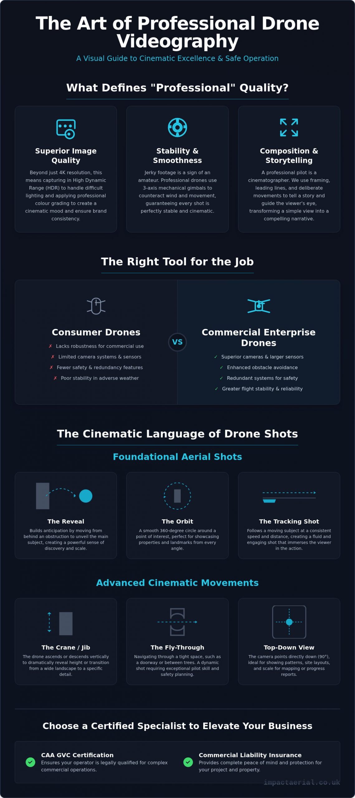
Technical Standards: 4K HDR and DJI Enterprise Technology
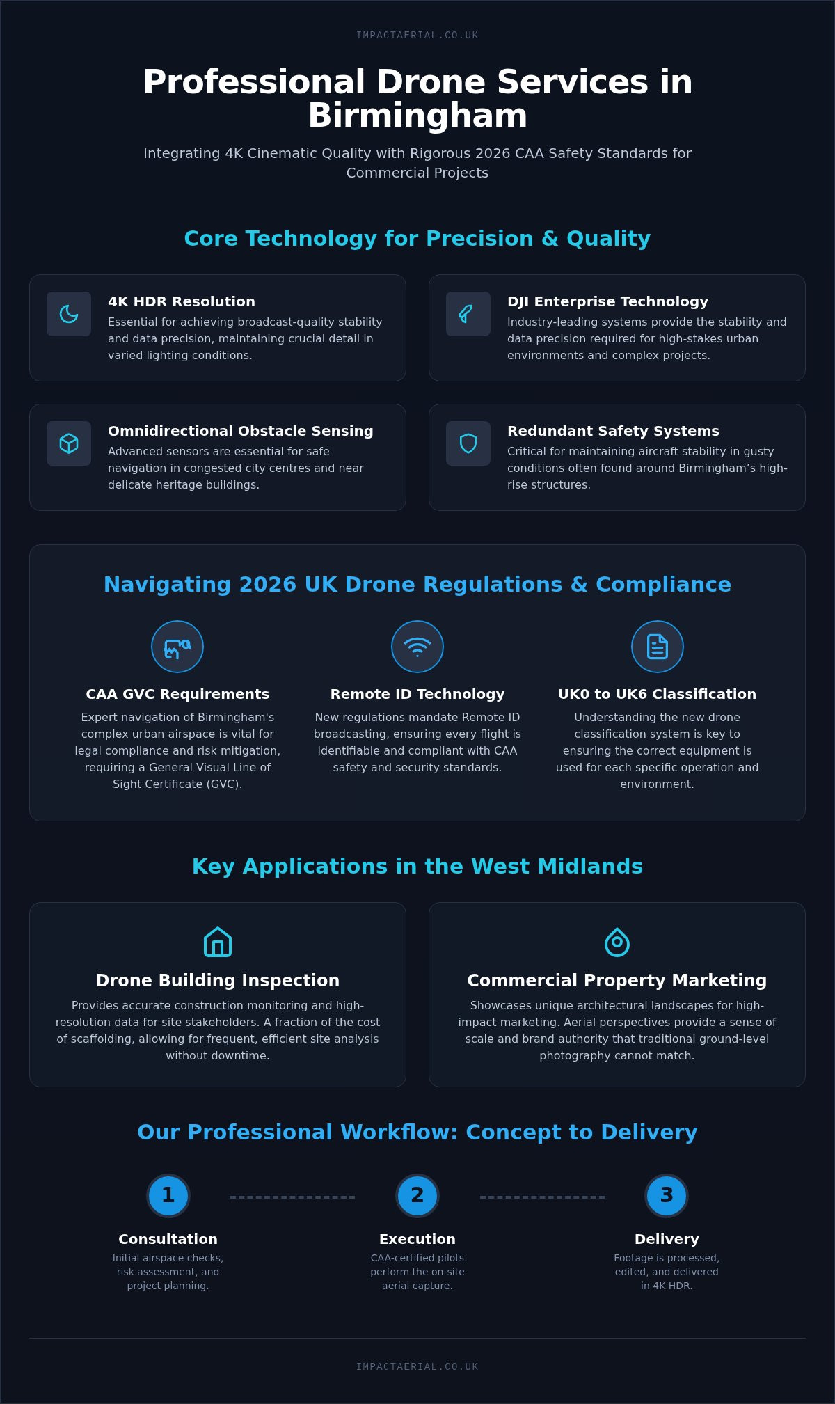
Achieving broadcast-quality results in a city as architecturally diverse as Birmingham requires more than just a standard consumer drone. For a professional drone building inspection birmingham, the technical specifications of the hardware are the foundations of every successful project. Impact Aerial employs industry-leading professional drone systems because they offer the stability and data precision required for high-stakes urban environments. Our advanced hardware represents the industry benchmark for reliability, reflecting the dominant market share held by top manufacturers in enterprise applications as of 2026. When you’re filming near the Bullring or the new HS2 developments, the ability to maintain a 4K HDR feed while navigating complex magnetic interference is a non-negotiable requirement for safety and quality.
The UK Civil Aviation Authority (CAA) has strict guidelines for Navigating Birmingham Airspace, especially given the proximity of Birmingham International Airport. Our Impact Aerial professional fleet is equipped with advanced obstacle avoidance and Remote ID technology, ensuring every flight is as compliant as it is visually stunning. This hardware isn’t just about the camera; it’s about the redundant systems that keep the aircraft stable in the gusty conditions often found around Birmingham’s high-rise structures. Balancing a large camera sensor with the agility needed for tight city centre flights is a technical challenge that only professional-grade equipment can solve.
The Professional Fleet Advantage
Our advanced professional fleet provides three critical advantages for West Midlands commercial projects. First, omnidirectional obstacle sensing is essential for safe navigation in congested city centres and near delicate heritage buildings. Second, High Dynamic Range (HDR) is crucial for maintaining detail during the flat, grey light conditions common in the UK. Finally, advanced battery management allow for comprehensive site coverage in a single flight, which is particularly useful for a drone building inspection birmingham where time on-site must be minimised.
From Raw Footage to Polished Edit
Capturing the footage is only the first stage of our workflow. Raw aerial data is often flat to allow for maximum flexibility in the edit. Our post-production services transform these files into cinematic marketing assets through expert colour grading and sound design. For construction site monitoring, we integrate professional graphics and data overlays that clearly show project milestones to stakeholders. Whether you need a punchy 15-second clip for social media or a detailed 10-minute progress report, we optimise every delivery format for its intended audience. If you’re ready to see how high-end tech can elevate your next project, you can explore our drone survey and data collection services.
Safety and Compliance: Navigating Birmingham Airspace
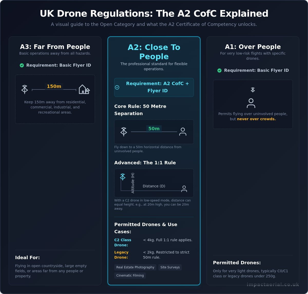
Birmingham’s urban landscape presents a sophisticated challenge for aerial operations, primarily due to its complex airspace and dense population centres. Much of the city, particularly the eastern corridors, sits within the Flight Restriction Zone (FRZ) of Birmingham International Airport (BHX). Conducting a professional drone building inspection birmingham in these areas isn’t just about pilot skill; it’s about meticulous legal coordination with Air Traffic Control. The UK Civil Aviation Authority (CAA) updated the regulatory framework on 1 January 2026, introducing the UK0 to UK6 classification system. We ensure every flight remains fully compliant with these latest standards, including the mandatory use of Remote ID for all new enterprise aircraft.
Risk mitigation is the cornerstone of our operational philosophy. Before any rotors turn, we conduct comprehensive site surveys and desk-based assessments to identify potential hazards, from high-tension power lines to local micro-climates. To protect our clients from unforeseen liabilities, we carry £5m commercial liability insurance as a standard requirement. This level of coverage is essential for West Midlands businesses that value security and professionalism over the risks associated with uncertified operators.
Why GVC Certification Matters
The legal distinction between a hobbyist and a professional provider of drone services has never been clearer. For commercial work in congested urban areas, a pilot must hold a General Visual Line of Sight Certificate (GVC). This qualification demonstrates a high level of airmanship and a deep understanding of the 2026 drone license regulations. Our commitment to these safety protocols ensures that every drone building inspection birmingham project is executed within the strict confines of the law, protecting your brand’s reputation and ensuring the safety of the public.
Urban Risk Management
Managing flight paths over public spaces like Centenary Square or the Bullring requires a disciplined approach to urban risk. We don’t just focus on the flight itself; we manage the entire operational environment. This includes:
- Implementing strict cordons and using spotters to manage ground-level safety.
- Adhering to GDPR and privacy regulations to ensure that bystanders and neighbouring properties are protected.
- Securing specific permissions for filming near sensitive heritage sites or government buildings.
By handling these logistical hurdles, we allow our clients to focus on the results. Whether we’re navigating the historic Jewellery Quarter or modern infrastructure projects, our goal is to provide total psychological comfort through technical and regulatory excellence.
Industry Applications for Aerial Video in the West Midlands
The versatility of UAV technology has made it an indispensable tool across diverse sectors in the West Midlands. In commercial property, we move beyond simple snapshots to create high-impact real estate photography and cinematic video that captures the full context of a development. This isn’t just about aesthetics; it’s about providing a comprehensive view of transport links and local amenities that ground-level cameras cannot reach. For the construction sector, construction site monitoring has become the standard for stakeholder reporting, allowing project managers to track progress with high precision. Beyond marketing and construction, our PV solar farm thermal surveys and critical infrastructure inspections support the region’s energy sector. Even the tourism and advertising industries benefit, as we showcase Birmingham’s vibrant culture and large-scale events from perspectives that reveal the city’s true scale.
Property and Development Marketing
Selling a location requires more than just showing the building. It’s about highlighting the proximity to New Street Station or the accessibility of the M6. We create immersive virtual tours that provide a seamless experience for potential tenants, driving enquiries by allowing them to explore a space before a physical visit. Capturing luxury residential developments in Digbeth or the Jewellery Quarter during the golden hour provides that aspirational quality that high-end brands demand. These visuals don’t just show a property; they sell a lifestyle and a strategic location to global investors.
Technical Surveys and Inspections
The use of specialized survey drones has revolutionized how we approach maintenance. Executing a drone building inspection birmingham wide allows for detailed roof and facade analysis without the cost or risk of scaffolding. We provide thermal imaging that identifies heat loss or moisture ingress, facilitating preventative maintenance for commercial landlords and facility managers. This data-centric approach is equally valuable for topographical mapping and large-scale land development projects. If you need to secure accurate data or cinematic marketing assets for your next West Midlands project, you can contact our professional aerial filming team today.
The Impact Aerial Workflow: From Concept to Delivery
Professional aerial operations require more than just technical skill; they necessitate a structured, methodical workflow that prioritises client goals and aviation safety. We approach every project as a technical consultancy, ensuring the transition from initial concept to high-end delivery is seamless and compliant. Whether we’re conducting a high-resolution drone building inspection birmingham wide or capturing cinematic marketing assets, our process is designed to provide total psychological comfort through every phase of the mission.
Step 1: Consultation and Planning
The process begins with a deep dive into your specific project requirements. We define the brief and identify the exact deliverables you need, whether that’s raw thermal data for a solar farm or a polished promotional film for a new commercial development. During this stage, we handle the complex logistics of securing permissions for restricted urban areas and private land. We monitor weather patterns and sun positions to schedule flights for optimal lighting conditions. This meticulous planning phase is where we conduct our site-specific risk assessments, ensuring every operational detail is locked down before we arrive on-site.
Step 2: Professional Execution and Editing
On-site, our GVC certified pilots execute the flight plan with surgical precision. We understand that commercial sites are busy environments, so we conduct our operations with minimal disruption to your daily business activities. If we’re performing a drone building inspection birmingham for a construction firm, we ensure all data points are captured systematically and safely. We often review raw footage with clients while on-site to allow for immediate feedback and any necessary adjustments.
Once the flight is complete, the project moves to our post-production suite. Here, we transform raw data into an aerial filming drone masterpiece. This includes professional colour grading, sound design, and the integration of graphics or data overlays. The result is a high-tier visual asset delivered via secure file transfer, ready for broadcast, social media, or stakeholder reporting. Our workflow ensures that the final output isn’t just a video, but a strategic tool that meets your specific business objectives.
Securing the Future of Your West Midlands Projects
Professional aerial videography has evolved into a critical technical service that balances cinematic artistry with rigorous aviation compliance. By choosing a specialist who understands the nuances of Birmingham’s urban airspace, you’re investing in more than just footage; you’re securing a compliant, high-resolution data asset. Whether your project requires a technical drone building inspection birmingham or a high-impact marketing campaign, the combination of 4K HDR technology and meticulous planning ensures a superior outcome.
As Birmingham and West Midlands specialists, we provide the technical expertise and legal assurance your business demands. Our GVC certified pilots operate with £5m public liability insurance, using industry-leading DJI Enterprise hardware to deliver precision in every frame. We manage the entire process, from complex airspace permissions to final post-production, so you can focus on your project’s success with total peace of mind.
We’re ready to help you transform your next commercial development with stunning visuals and accurate data. Request a Professional Aerial Videography Quote for Your Birmingham Project and take the first step towards a safer, more cinematic perspective.
Frequently Asked Questions
Do you need a permit to fly a drone in Birmingham city centre?
Yes, operating a drone in Birmingham city centre requires specific permissions due to the dense urban environment and proximity to Birmingham International Airport. As the city falls within complex airspace, professional pilots must coordinate with Air Traffic Control and potentially local authorities. Our GVC certified pilots manage these logistics as part of our standard workflow to ensure every flight is fully legal and safe.
How much does aerial videography in Birmingham typically cost?
The cost of professional aerial services depends on the project’s complexity, the required hardware, and the level of post-production needed. Factors such as the location’s risk profile and the duration of the shoot also influence the final investment. We provide bespoke quotes that reflect the specific technical requirements and deliverables of your West Midlands commercial project.
Can drones fly in the rain or high winds common in the West Midlands?
Our DJI Enterprise drones are designed with high wind resistance, allowing for stable flight in conditions that would ground hobbyist equipment. However, we generally avoid operating in heavy rain to protect the sophisticated optical sensors and ensure the highest data quality. Safety remains our primary concern; we won’t fly if the conditions compromise the aircraft or the integrity of the footage.
What insurance cover does Impact Aerial carry for commercial projects?
We carry £5m commercial liability insurance as a standard requirement for all our operations. This significant level of cover is essential for high-stakes environments, such as a drone building inspection birmingham, providing our clients with total peace of mind. It ensures that your business is protected against unforeseen events during any phase of the aerial operation.
How long does it take to get the final edited drone video?
Turnaround times vary based on the project’s scope, but we typically deliver raw data for a drone building inspection birmingham within 48 hours. For fully edited cinematic films, the post-production process usually takes between five and ten working days. We provide a clear timeline during the initial consultation to ensure our delivery aligns with your project milestones.
Are your pilots CAA GVC certified for urban environments?
Yes, all our pilots hold the General Visual Line of Sight Certificate (GVC), which is the legal standard for commercial work in congested urban areas. This certification demonstrates a high level of technical competence and a thorough understanding of the latest 2026 UK drone regulations. It’s a non-negotiable requirement for safely navigating Birmingham’s complex city centre architecture.
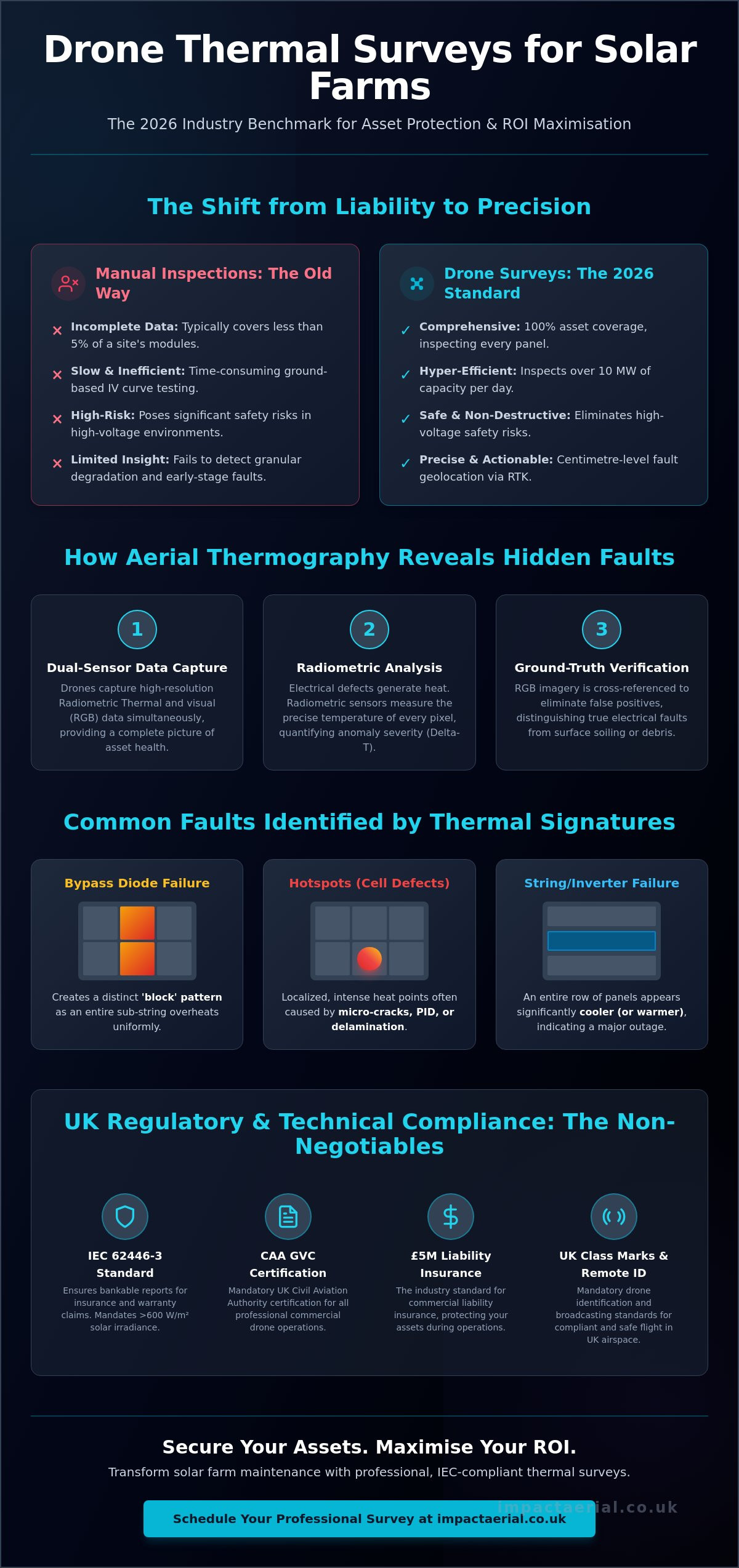
Can you provide thermal imaging for solar farms in the Birmingham area?
We provide specialized PV Solar Farm Thermal Surveys using advanced DJI Enterprise hardware equipped with radiometric sensors. This technology allows us to identify cell defects, bypass diode failures, and string issues with high precision. Our thermal imaging services help solar farm operators in the West Midlands maintain peak energy efficiency through preventative maintenance.
What happens if the weather is too poor on the scheduled filming day?
We monitor weather forecasts meticulously in the days leading up to a shoot and will notify you if conditions look unfavourable. If the weather is too poor for safe operation, we simply reschedule the flight to the next available window at no additional cost to the client. This policy ensures we only fly when we can guarantee both safety and the highest visual quality.