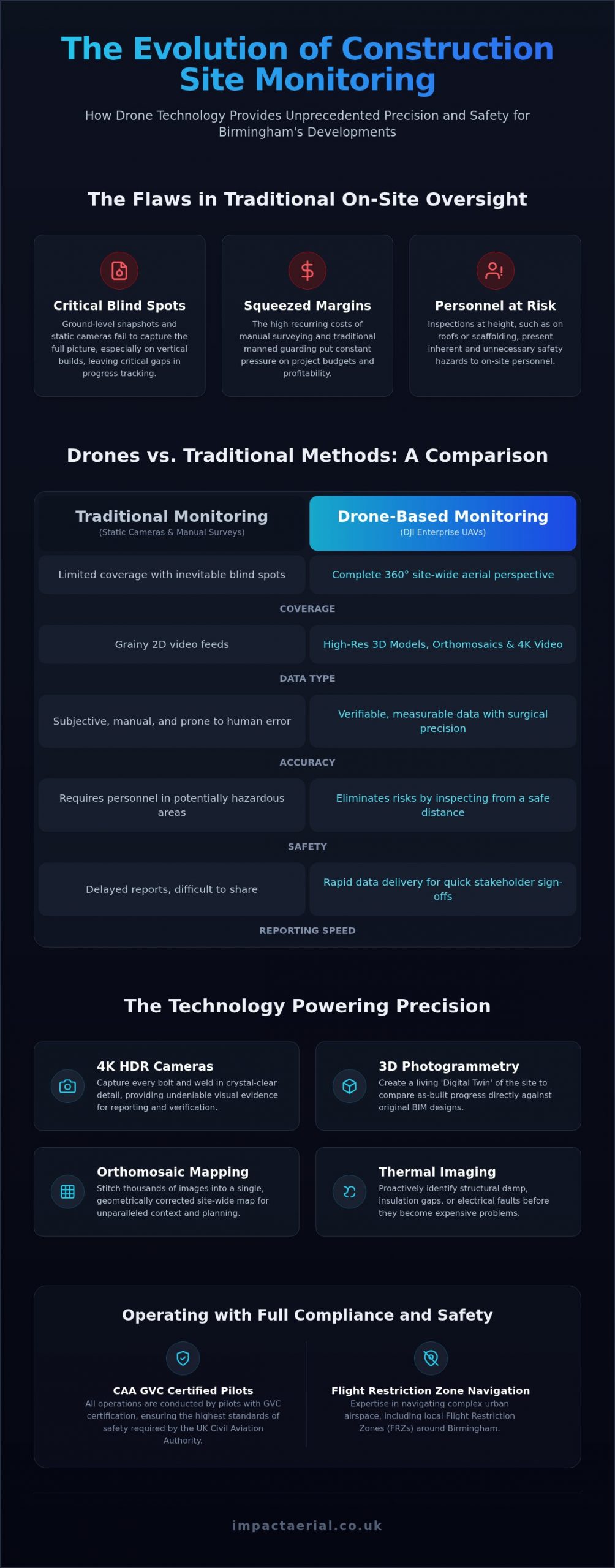
If you are managing a multi-million pound development in Digbeth or the Jewellery Quarter, can you truly say you know exactly what happened on-site at 2:00 PM yesterday? Relying on ground-level snapshots often leaves critical gaps in construction site monitoring birmingham developers can no longer afford to ignore. Traditional reporting is frequently plagued by inaccuracies that lead to project delays, while the high costs of manual surveying and traditional manned guarding continue to squeeze margins in an increasingly competitive market.
It is understandable that you want total oversight without the logistical headache of constant physical inspections. This guide explores how drone-based monitoring provides the data-rich, 360-degree perspective you need to track progress, ensure safety, and manage complex sites with absolute precision. We’ll look at the latest 2026 DJI Enterprise hardware, the necessity of CAA GVC certified pilots, and how high-resolution aerial evidence is now the industry standard for maintaining project timelines and safety compliance across the West Midlands.
Key Takeaways
- Learn how high-resolution UAV imagery and 3D data capture are transforming site management from reactive security to proactive project oversight.
- Understand the safety and cost advantages of replacing manual surveying with aerial inspections that identify hazards without risking personnel.
- Discover the specific regulatory requirements for construction site monitoring birmingham projects, including CAA GVC certifications and navigating local Flight Restriction Zones.
- Compare the limitations of static 2D security cameras against the mobility and depth of 3D photogrammetry models produced by DJI Enterprise hardware.
- Identify why local expertise and professional-grade equipment are essential for maintaining a single source of truth across complex West Midlands developments.
What is Modern Construction Site Monitoring?
Modern construction site monitoring birmingham is no longer defined by a guard at a gate or a static camera on a pole. In 2026, it represents a sophisticated integration of an Unmanned aerial vehicle (UAV) to capture high-resolution imagery and 3D data. This shift allows developers to move from reactive security measures toward proactive project management. Instead of just preventing theft, you’re now using aerial data to track every phase of the build with surgical precision.
Birmingham’s skyline is evolving rapidly with high-rise developments in areas like Great Charles Street and Broad Street. This vertical growth makes traditional ground-level inspections nearly impossible to conduct accurately. Drones provide the necessary perspective to maintain a ‘digital twin’ of the site. This is a living 3D model that reflects the exact state of construction at any given moment, allowing for immediate comparison against original BIM designs and schedules.
To better understand how these flights operate in practice, watch this helpful video:
The Difference Between Security and Progress Monitoring
Fixed CCTV cameras are excellent for boundary protection, but they inevitably leave blind spots as a building grows taller and more complex. Progress monitoring focuses on what’s happening inside the structure and across the upper floors. It provides measurable data points rather than just a grainy video feed. This level of detail supports stakeholder reporting by giving investors a clear, high-definition view of where their money is going. It turns visual evidence into a tool for transparency and accountability that ground-level security simply cannot match.
Key Technologies Used in 2026
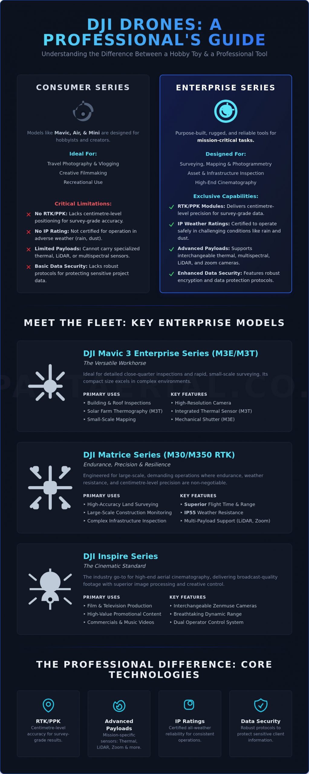
The standard for professional monitoring has moved far beyond hobbyist equipment. At Impact Aerial, we utilise DJI Enterprise drones with 4K HDR cameras to ensure every bolt and weld is visible in the final output. Beyond simple photos, we use orthomosaic mapping to stitch thousands of images together into a single, geometrically corrected map with site-wide accuracy. Additionally, thermal imaging is now a vital part of the 2026 workflow. By detecting heat signatures, we can identify structural damp or electrical faults long before they become expensive repair jobs, ensuring the site remains both safe and on budget.
The Benefits of Drone-Based Monitoring for Birmingham Projects
Integrating drone technology into your workflow offers advantages that traditional methods cannot match. While competitors often focus solely on perimeter security, professional construction site monitoring birmingham provides a comprehensive toolkit for risk management and operational efficiency. By deploying enterprise-grade UAVs, developers gain a level of oversight that is both safer and more cost-effective than manual site walks.
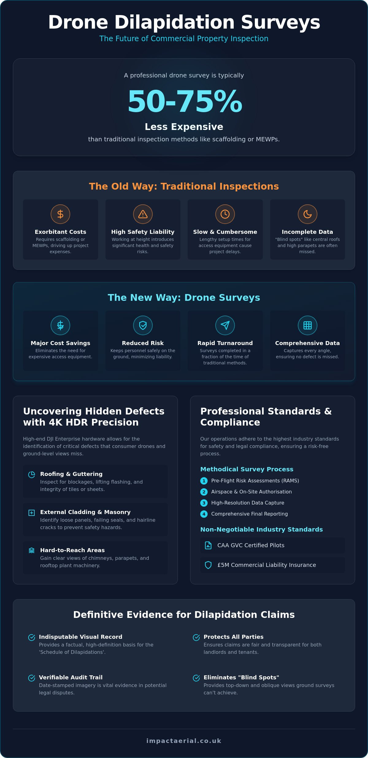
Improving Site Safety and Risk Mitigation
Traditional roof inspections often involve scaffolding or cherry pickers, which present inherent risks to personnel. Drones eliminate these hazards by capturing high-resolution data from a safe distance. Beyond elevations, aerial views are essential for identifying plant machinery bottlenecks and optimizing traffic flow within tight urban sites. By adhering to UK Civil Aviation Authority drone regulations, we ensure that every flight is conducted with the highest safety standards. Aerial perspectives provide a comprehensive view of the site that allows project managers to identify and rectify potential hazards before they result in accidents.
Data Accuracy and Project Timelines
One of the most significant advantages of drone-based monitoring is the ability to compare “as-built” data directly against original CAD designs. This ensures that any deviations are caught early, preventing costly rework later in the project. We use time-lapse drone footage to document every phase of the build, creating a verifiable historical record. This high-resolution evidence significantly speeds up sign-offs from valuers and surveyors, as they can review the site’s progress remotely with total confidence in the data’s accuracy. If you’re looking to streamline your reporting, our construction site monitoring services provide the precision you need.
Cost-efficiency is a primary driver for adopting this technology. A single flight can replace hours of manual surveying, reducing labor costs and freeing up staff for high-value tasks. Additionally, the environmental impact is reduced through fewer site visits and more efficient resource allocation. By capturing the “big picture” alongside specific technical close-ups, drones offer a dual-purpose solution that serves both the boardroom and the site office.
Drones vs. Traditional Site Monitoring: A Comparison
Static surveillance has long been the backbone of site security, yet it often fails to provide the dynamic data required for modern construction site monitoring birmingham projects. While a fixed camera can monitor a primary entrance, it cannot verify the structural integrity of a fifth-floor slab or identify a leak in a remote corner of a sprawling development. A DJI Enterprise drone moves with the project. It covers significantly more ground than a traditional guard in a fraction of the time, providing a level of mobility that static infrastructure simply cannot match. This shift from 2D security footage to 3D photogrammetry models allows for a depth of analysis that was previously impossible.
The setup process also highlights a stark contrast between old and new methods. Traditional monitoring requires a heavy investment in cabling, permanent poles, and consistent power supplies. Drones are operational in minutes. This agility allows for rapid incident response; if a project manager needs to inspect a high-elevation hazard, a drone reaches that location in seconds. It provides real-time 4K visual data without the need for scaffolding or risky manual climbs, ensuring that “eyes on the ground” are supported by a superior “eye in the sky.”
Cost-Benefit Analysis
Comparing the Total Cost of Ownership reveals that drone-based monitoring is often more economical than 24/7 manned guarding. While physical security is vital for perimeter control, it lacks the sophisticated data-gathering capabilities of a UAV. A single aerial survey can replace several specialized teams, consolidating progress reporting, safety audits, and topographical updates into one efficient flight. This professional approach is underpinned by the UK drone safety and registration rules, which ensure that commercial operations are conducted within a strict legal framework. The high-resolution evidence captured also serves as indisputable proof in contract disputes or insurance claims, protecting your margins from unforeseen costs.
Integration with Existing Security
Drones shouldn’t replace every ground-based measure. Instead, they should form the top layer of a multi-tiered security and monitoring strategy for Birmingham sites. When integrated with biometric access control and ground-level CCTV, drones provide the context that validates ground-level alerts. For complex urban sites with high-value plant machinery, this layered approach ensures there are no blind spots. If a ground sensor is triggered, a drone can be deployed immediately to provide a wide-angle view of the situation. This allows for a faster and more informed response than a guard on foot could ever manage, creating a more resilient and secure site environment.
Compliance and Safety: Flying in Birmingham Airspace
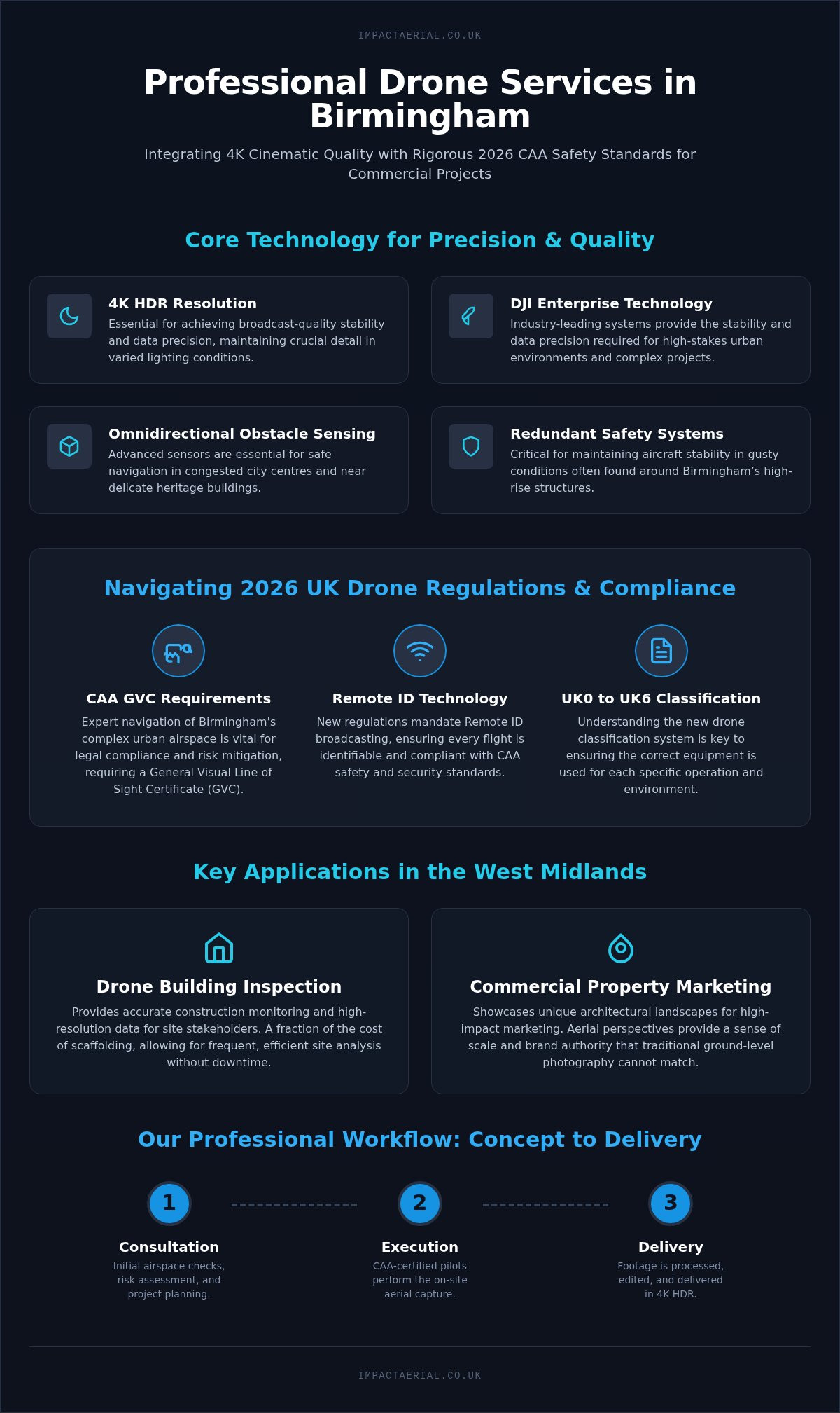
Birmingham’s urban environment presents unique challenges that demand a meticulous approach to compliance. Unlike rural projects, construction site monitoring birmingham requires navigating a complex web of aviation laws and local restrictions. Operating a drone commercially in the UK in 2026 necessitates a General Visual Line of Sight Certificate (GVC) issued by the Civil Aviation Authority (CAA). This qualification ensures that pilots possess the technical knowledge to manage risks in congested areas. Hiring an uncertified hobbyist isn’t just a safety risk; it exposes your business to significant legal liabilities and potential fines from the CAA.
Regulatory Standards for 2026
Impact Aerial stays current with all legislative transitions, ensuring our operations remain fully compliant with the latest UK drone safety and registration rules. Our pilots hold current Flyer IDs and Operator IDs, which are mandatory for all professional flights. We implement specific safety protocols when flying over active construction personnel, including defined take-off zones and emergency fail-safe procedures. This level of meticulousness provides the psychological comfort that your project is being monitored within the strictest legal boundaries.
Local Birmingham Airspace Challenges
The city’s geography includes several sensitive zones that require expert navigation. Managing flights near the Birmingham Airport Flight Restriction Zone (FRZ) or the Queen Elizabeth Hospital helipad demands direct coordination with Air Traffic Control (ATC). We also account for specific infrastructure projects like HS2 Curzon Street, which may have temporary airspace restrictions. Our team conducts a detailed pre-flight risk assessment for every deployment, identifying potential hazards before the drone even leaves the ground. This includes working with local authorities to secure permissions for city centre operations.
Privacy, Insurance, and GDPR
In densely populated areas like Digbeth or the Jewellery Quarter, privacy is a paramount concern. We adhere to strict GDPR best practices, ensuring that data capture is focused solely on the site and that any incidental footage of the public is handled according to legal standards. Safety is reinforced by our £5m commercial liability insurance, a necessary safeguard for high-stakes urban infrastructure. This level of coverage is essential for protecting your assets and maintaining professional standards across the West Midlands.
If you need a partner who understands the complexities of urban aviation law, you can book a compliant site survey with our expert team today.
Why Choose Impact Aerial for Birmingham Site Monitoring?
Impact Aerial is more than just a drone operator; we’re a technical consultant for the West Midlands’ most ambitious developments. Our approach to construction site monitoring birmingham is built on a foundation of local knowledge and high-tier hardware. Being based in the heart of the region allows us to provide a level of responsiveness that national agencies simply can’t match. We understand the specific logistical challenges of the city, from navigating complex urban canyons to coordinating with local authorities for city-centre permissions.
We utilize DJI Enterprise-grade hardware equipped with 4K HDR cameras. This provides a level of visual clarity that reveals technical details often missed by consumer-grade equipment. However, the flight is only the first step. Our post-production excellence ensures that raw data is processed into actionable insights for your engineering and management teams. We don’t just deliver a folder of images. We provide structured, high-resolution evidence that supports every stage of the build, from initial groundworks to final completion. This commitment to quality has established our proven track record across the property, construction, and advertising sectors.
Our Birmingham-Centric Approach
Our team is deeply involved in supporting major regeneration projects, including high-profile developments in the Jewellery Quarter and surrounding districts. We align our safety protocols with the rigorous requirements of Tier 1 contractors, ensuring that our presence on-site never compromises operational standards. Because we’re local, we offer fast response times for site managers who need urgent inspections or rapid progress updates. This proximity allows us to be an integrated part of your project team rather than a distant third-party vendor. We take pride in being a trusted specialist that understands the specific geography and regulatory landscape of the West Midlands.
Request a Consultation for Your Next Project
Every project has unique milestones, and we tailor our monitoring packages to meet those specific needs. Whether you require weekly progress reports for internal tracking or monthly high-resolution surveys for stakeholder meetings, our process is designed for reliability. We start with an initial consultation to understand your data requirements and site constraints. From there, we handle all flight planning, risk assessments, and post-production, delivering the final data through a streamlined digital workflow. Professional construction site monitoring birmingham is about more than just pictures; it is about providing the psychological comfort and tangible data that keeps projects on track.
If you’re ready to enhance your project oversight with precision data, contact Impact Aerial today for a professional site monitoring quote.
Future-Proofing Your Birmingham Development
The landscape of West Midlands infrastructure is shifting toward a data-first approach. By moving beyond traditional ground-level security, developers are now using 3D photogrammetry and 4K HDR imagery to maintain a single source of truth for their projects. Professional construction site monitoring birmingham ensures that every phase of your build is documented with surgical precision. This reduces the risk of costly delays and provides high-resolution evidence for all stakeholders, from investors to site managers.
The transition from reactive security to proactive management allows for better safety compliance and significant cost reductions across the project lifecycle. Our team of West Midlands local experts is ready to support your next development with the meticulousness your project deserves. We bring the reassurance of CAA GVC certified pilots and £5m commercial liability insurance to every flight, ensuring your site remains compliant and secure in even the most congested urban environments.
Take the next step in optimizing your site’s efficiency and safety. Book Your Birmingham Construction Site Monitoring Consultation today and gain the 360-degree perspective your project needs to succeed.
Frequently Asked Questions
Is drone monitoring legal on construction sites in Birmingham city centre?
Drone monitoring is entirely legal in Birmingham city centre when conducted by a CAA GVC certified pilot. While the city has complex airspace, including Flight Restriction Zones near the airport and helipads, professional operators coordinate directly with Air Traffic Control. We ensure every flight adheres to strict safety protocols and is backed by £5m commercial liability insurance to protect your assets in congested urban areas.
How often should we fly the drone for effective site monitoring?
The frequency of flights usually aligns with your specific project milestones or valuation cycles. Many developers opt for weekly construction site monitoring birmingham visits to track rapid progress, while others prefer monthly high-resolution surveys for stakeholder reporting. We tailor these schedules to provide a consistent “single source of truth” that matches your project’s pace and reporting requirements.
Can drone monitoring help with insurance claims on construction sites?
High-resolution aerial data serves as undisputable evidence in the event of an insurance claim or contract dispute. Because drone captures are time-stamped and geometrically accurate, they provide a clear record of site conditions at specific dates. This documentation is invaluable for verifying “as-built” progress against CAD designs or proving that safety protocols were in place before an incident occurred.
What kind of data will I receive from a drone monitoring session?
You’ll receive a suite of data-rich deliverables tailored to your team’s needs. This typically includes 4K HDR progress photography, orthomosaic maps for site-wide accuracy, and 3D photogrammetry models. We also provide post-production services to ensure the raw data is edited and processed into professional reports that are ready for immediate use by stakeholders and project managers.
Do I need to inform my neighbours about drone flights for site monitoring?
Notifying neighbours is considered a best practice for maintaining transparency and ensuring GDPR compliance. While your site is private property, professional drone operators conduct thorough pre-flight risk assessments that include stakeholder management. We handle the logistical side of privacy, ensuring that any incidental data capture of the surrounding Birmingham community is managed according to current data protection laws.
Can drones fly in the typical Birmingham wind and rain?
Enterprise-grade drones are designed to operate in challenging weather conditions, including light rain and moderate winds. Our hardware features high IP ratings for moisture resistance and can maintain stability in wind speeds of approximately 12 metres per second. While we prioritize safety and will ground flights in extreme storms, the reliability of modern technology ensures minimal disruption to your monitoring schedule.
How does drone monitoring integrate with my existing BIM software?
Drone data integrates seamlessly with most Building Information Modelling (BIM) and project management software. We export files in standard formats such as .OBJ, .LAS, or .TIFF, which allow you to overlay 3D aerial models onto your original CAD designs. This creates a “digital twin” that helps identify structural deviations early, ensuring the project stays aligned with the intended architectural plans.
What is the difference between a survey drone and a standard filming drone?
The primary difference lies in data precision and specialized sensor technology. While standard filming drones capture high-quality visuals, survey drones utilize RTK (Real-Time Kinematic) positioning for centimetre-level accuracy. They also feature mechanical shutters to eliminate image distortion and can carry thermal sensors. These technical capabilities are essential for generating the measurable data points required for professional site monitoring.