
What if the biggest threat to your construction project’s budget isn’t labour costs or material prices, but the data you’re working from? For site managers and project directors across the UK, inaccurate topographic surveys, slow manual inspections, and mounting health and safety risks are creating a compounding problem that traditional methods simply can’t solve fast enough. Drone surveying for construction has moved well beyond a novelty; it’s now a precision data service that directly bridges the gap between physical site reality and digital project management.
If you’ve felt the frustration of costly rework caused by outdated ground surveys, or you’re uncertain about CAA regulations and what qualifications a compliant drone operator actually needs, you’re not alone. These are the practical barriers that prevent construction businesses from realising the genuine efficiency gains this technology delivers.
This guide cuts through the confusion. You’ll find a clear breakdown of how professional drone surveying improves topographic accuracy, supports BIM workflows, strengthens health and safety reporting, and delivers measurable ROI, along with what to look for in a compliant, qualified operator for your next UK project.
Key Takeaways
- Drone surveying for construction delivers georeferenced topographic data, orthomosaic maps, and 3D point clouds that directly feed into BIM workflows, replacing outdated manual methods with quantifiable digital outputs.
- Professional drone surveys can reduce data collection timelines significantly, with processed deliverables typically available within 24 hours of a site flight, directly cutting project delays caused by slow traditional survey teams.
- The ROI case extends beyond speed: accurate volumetric and spatial data reduces costly rework, supports progress reporting, and strengthens health and safety documentation across active construction sites.
- UK compliance is non-negotiable — understanding CAA GVC certification requirements and what constitutes a legally compliant operator is essential before commissioning any aerial survey on a congested or built-up site.
- This guide explains what to look for in a qualified, insured drone surveying partner, and how Birmingham-based operators with UK-wide reach can deliver turnkey construction data solutions without adding management burden to your team.
What is Drone Surveying for Construction?
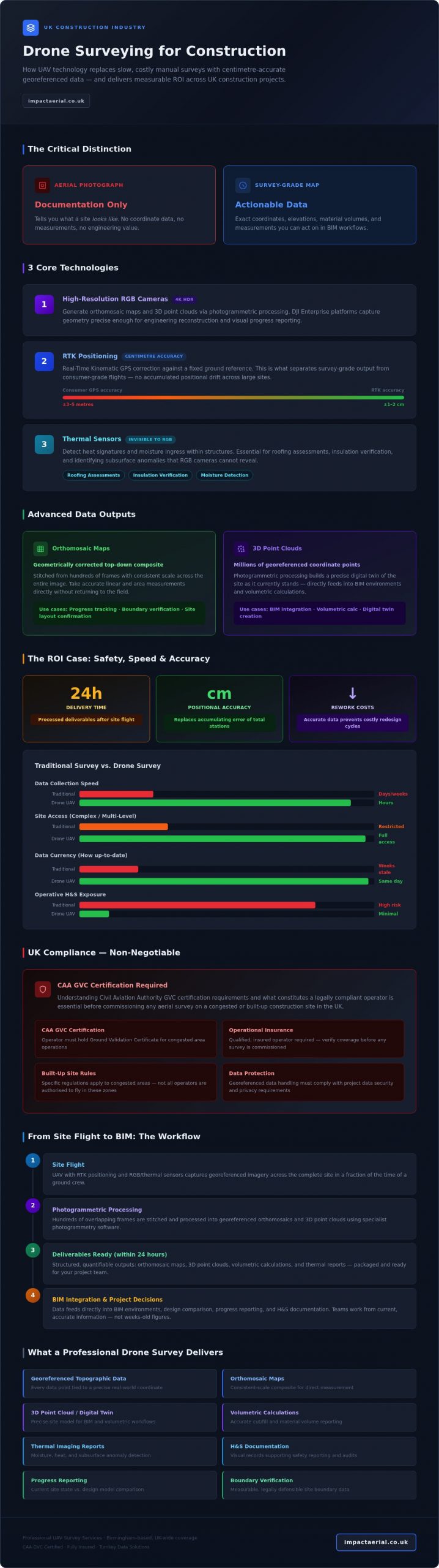
At its core, drone surveying for construction is the deployment of Unmanned Aerial Vehicles (UAVs) fitted with specialist sensors to capture georeferenced spatial data across a site. The critical word here is georeferenced. Every data point captured is tied to a precise coordinate in the real world, making the output a quantitative engineering asset rather than a visual record. This is the fundamental distinction that separates a professional survey from an aerial photograph.
A standard drone photo tells you what a site looks like. A survey-grade map tells you exactly where everything is, how high it sits, how much material is present, and how those measurements compare to your design model. One is documentation; the other is data you can act on.
By 2026, the construction sector is reaching a genuine tipping point in aerial data adoption. Advances in onboard processing, RTK positioning, and photogrammetric software have reduced the barrier to survey-grade accuracy considerably, while increasing pressure on project margins and programme certainty is making the business case for faster, more reliable site data impossible to ignore.
This global shift is evidenced by the rise of specialized European providers like Aeroshot, who offer comprehensive Drone-gebaseerde inspectie- en visualisatiediensten to help contractors visualize progress and inspect critical infrastructure with high-precision 3D models.
The Evolution from Manual to Aerial Surveying
Traditional total station surveys require a ground crew to physically occupy multiple positions across a site, a process that’s time-consuming, weather-dependent, and introduces accumulating positional error over large areas. Aerial photogrammetry captures the same spatial relationships from above in a fraction of the time. Industry professionals consistently report reductions in field data collection time when comparing UAV-based methods to conventional survey crews, particularly across complex or multi-level sites where ground access is restricted. The downstream effect on project timelines is direct: faster data collection means design teams and site managers are working from current information, not figures that were accurate three weeks ago.
Key Technologies Powering Construction Drones
Three core technologies define what a professional construction drone system can deliver:
- High-resolution RGB cameras: Used to generate orthomosaic maps and 3D point clouds through photogrammetric processing. On hardware such as DJI Enterprise platforms, 4K HDR capture supports both visual reporting and precise geometric reconstruction.
- RTK (Real-Time Kinematic) positioning: Corrects GPS signals against a fixed ground reference in real time, achieving centimetre-level positional accuracy without relying solely on ground control points. This is what separates a survey-grade output from a consumer-grade flight.
- Thermal sensors: Detect heat signatures and moisture ingress within structures, making them particularly valuable for roofing assessments, insulation verification, and identifying subsurface anomalies that RGB imagery simply can’t reveal.
Together, these technologies shift drone surveying from a visual inspection tool into a precision data service that feeds directly into BIM environments, volumetric calculations, and progress reporting workflows.
Advanced Data Outputs: Orthomosaics, LiDAR, and BIM
Understanding what a drone captures during a flight is one thing. Understanding what gets delivered to your project team afterwards is what actually drives decisions. The raw imagery collected during a construction survey is processed into a set of structured, quantifiable outputs, each serving a specific function within the project data chain.
An orthomosaic map is a geometrically corrected, top-down composite image stitched from hundreds of individual frames. Unlike a standard aerial photograph, which distorts geometry at its edges, an orthomosaic maintains consistent scale across the entire image. This means you can take accurate linear and area measurements directly from the map, making it a practical tool for progress tracking, boundary verification, and site layout confirmation without returning to the field.
3D point clouds take this further. Photogrammetric processing converts overlapping images into millions of georeferenced coordinate points, constructing a precise digital twin of the site as it currently stands. This is the foundation for Digital Surface Models (DSM), which represent everything visible from above including structures, stockpiles, and vegetation, and Digital Elevation Models (DEM), which represent the bare earth terrain beneath. The distinction matters: a DSM tells you where your spoil heap sits; a DEM tells you what the ground beneath it looks like. Both are essential for accurate earthworks planning and drainage design.
Volumetric analysis is where the commercial case becomes immediately tangible. Calculating stockpile volumes using traditional survey methods typically requires a ground crew, significant time on site, and manual calculation workflows. Processed drone data can generate accurate volumetric figures from a single flight, cross-referenced against previous surveys to track material movement over time. For contracts where material quantities are tied to payment milestones, this level of auditability has direct financial value.
Photogrammetry vs. LiDAR: Choosing the Right Tool
Photogrammetry is the cost-effective default for most construction applications. It produces high-resolution 3D models from RGB imagery and performs well across open sites, earthworks, and structural surveys where clear sightlines exist. LiDAR uses pulsed laser measurements rather than image processing, which gives it one critical advantage: it can penetrate vegetation canopy to capture ground-level terrain data beneath. For UK infrastructure projects involving railway corridors, woodland clearance, or sites with dense ground cover, LiDAR produces terrain data that photogrammetry simply cannot match. Some complex projects benefit from a hybrid approach, using photogrammetry for surface-level structural detail and LiDAR for accurate ground modelling in obscured areas.
Integrating Aerial Data into BIM Workflows
The output formats from professional drone surveying for construction are designed to slot directly into the software environments your design and engineering teams already use. Point clouds export as LAS or LAZ files compatible with Autodesk Revit, AutoCAD Civil 3D, and Bentley MicroStation. Orthomosaics export as georeferenced GeoTIFFs. This means a survey drone flight translates directly into updated BIM reference data without requiring manual re-entry or format conversion by your team.
The practical application is ‘As-Built’ documentation. Design models reflect intent; site reality frequently diverges from it. Regular aerial surveys create a timestamped spatial record of what was actually built and when, giving project managers an objective basis for resolving disputes, validating contractor claims, and maintaining programme accountability. If you’re looking to close the gap between your design model and what’s happening on the ground, professional construction site monitoring provides the data layer that makes that comparison possible.
The ROI of Drone Surveys: Safety, Speed, and Accuracy
The business case for drone surveying for construction doesn’t rest on a single advantage. It compounds across three dimensions simultaneously: the cost of data collection falls, the speed at which decisions can be made increases, and the accuracy of the information underpinning those decisions improves. Each of these factors independently justifies the investment. Together, they represent a structural shift in how project data is managed.
Traditional survey teams working across a large active site can take several days to complete a full topographic capture, then additional time to process and deliver usable outputs. A professional drone survey compresses that timeline considerably. From flight completion to processed, georeferenced deliverables, a well-equipped operator can turn data around in under 24 hours. For a project manager waiting on updated ground levels before a concrete pour, that difference isn’t marginal; it’s the difference between programme certainty and a costly delay.
On accuracy, RTK-enabled drone systems routinely achieve sub-5cm positional accuracy across open construction sites when properly calibrated against ground control. That tolerance sits comfortably within the requirements for most earthworks, drainage, and structural setting-out applications. It also means the data is defensible: if a contractor dispute arises over quantities or levels, a timestamped, georeferenced dataset carries evidential weight that a manual field note simply doesn’t.
Stakeholder communication is a less-discussed but genuinely valuable application. Three-dimensional site models generated from drone data give clients, planners, and non-technical stakeholders a clear visual reference for progress that flat drawings can’t match. Presenting a photorealistic 3D model of the site as it stands today, overlaid against the design intent, removes ambiguity from progress meetings and accelerates sign-off decisions.
Improving On-Site Health and Safety
One of the most direct risk reduction benefits is removing the need for surveyors to physically access hazardous areas. Inspecting a partially constructed roof structure, traversing unstable embankments, or assessing a deep excavation perimeter all carry measurable risk under CDM regulations. Aerial survey eliminates that exposure entirely. High-resolution site overviews also support traffic management planning by providing an accurate, current picture of vehicle routing, pedestrian zones, and proximity conflicts that ground-level observation can miss. Hazard identification from above, including identifying unsecured materials, deteriorating temporary works, or encroachment into exclusion zones, adds a proactive layer to site safety reporting that’s difficult to replicate with conventional inspection methods.
Quantifying Time and Material Savings
Precise volumetric data reduces material waste by giving quantity surveyors accurate cut-and-fill figures before earthworks begin, rather than approximations that lead to over-ordering or unexpected shortfalls. Identifying deviations from the design model early, before subsequent trades build on top of an error, avoids the rework costs that consistently erode construction margins. The drone survey process, when managed by an experienced operator, is designed to integrate with existing project workflows rather than add a parallel management burden, meaning faster data, faster sign-offs, and fewer surprises at practical completion.
Navigating UK Regulations and Compliance for Construction
Commissioning drone surveying for construction without verifying your operator’s regulatory standing isn’t just a procurement oversight; it’s a liability that sits squarely with you as the client. The Civil Aviation Authority’s framework for commercial drone operations is specific, and construction sites, particularly those in urban or congested environments, sit in some of the most demanding operational categories the regulations cover. Understanding what compliance actually looks like is the first step to protecting your project.
Under the UK’s current CAA framework, commercial drone operations that go beyond the basic ‘Open’ category, which covers low-risk, recreational, and limited commercial flights, require operators to hold authorisation under the ‘Specific’ category. This is where the General Visual Line of Sight Certificate, or GVC, becomes the relevant qualification. Any professional pilot conducting surveys on active construction sites, particularly in built-up areas or near infrastructure, should hold GVC certification as a baseline credential. It’s not optional; it’s the regulatory threshold that separates a compliant commercial operator from one who’s operating outside their permitted boundaries.
Why Your Pilot Needs CAA GVC Certification
The GVC isn’t simply a licence to fly; it demonstrates that a pilot has completed structured training in operational risk assessment, airspace management, and emergency procedures specific to complex environments. A hobbyist ‘Open’ category registration covers a narrow set of low-risk scenarios and does not authorise operations over congested areas, near crowds, or in controlled airspace, all of which are common features of active UK construction sites. Before any operator steps onto your site, ask to see their drone licence documentation and their Operational Authorisation issued by the CAA. Both should be current and verifiable.
Compliant operators also produce a site-specific Operations Manual and conduct a formal risk assessment prior to each flight. These documents define the flight boundaries, emergency procedures, and contingency protocols for your specific site conditions. If a prospective operator can’t produce these on request, that’s a clear disqualifying signal.
The role of the Accountable Manager within a drone operating company is also worth understanding. This is the individual who holds formal responsibility for the organisation’s compliance with its CAA Operational Authorisation. A legitimate commercial operator will have a named Accountable Manager, and their existence within the company structure is a reliable indicator that the organisation takes its regulatory obligations seriously rather than treating compliance as an afterthought.
Operating in congested areas introduces additional requirements around flight planning, NOTAMs, and coordination with local air traffic where applicable. A qualified operator handles all of this before arriving on site, meaning your team doesn’t inherit the administrative burden of managing airspace compliance.
Insurance: Why £5m Liability is the Industry Standard
Beyond certification, insurance coverage is the second non-negotiable. The construction industry standard for commercial drone operators is £5m public liability insurance as a minimum. This figure isn’t arbitrary; it reflects the scale of potential third-party claims on a busy construction site where equipment, personnel, and neighbouring properties are all within range of a UAV operation.
Using an under-insured operator exposes your project to direct financial risk. If an incident occurs and the operator’s policy limit falls short of the resulting claim, liability can transfer to the principal contractor or site owner. Commercial drone insurance should cover third-party bodily injury, property damage, and, depending on the policy, payload equipment failure. What it typically won’t cover is data loss from processing errors or consequential project delays, which is why operator competence remains as important as the policy itself.
Verifying insurance is straightforward: request a copy of the certificate of insurance before works commence and confirm the coverage limit, the named insured, and the policy expiry date. A reputable operator will provide this without hesitation.
If you want to commission drone surveying for construction with the confidence that certification, insurance, and site-specific compliance are already in place, speak to a qualified operator who can provide documentation upfront.
Data protection is a further compliance consideration that’s frequently overlooked. Aerial imagery captured over active sites may incidentally record identifiable individuals or neighbouring properties, bringing GDPR obligations into scope. A compliant operator will have a documented data handling policy covering image retention, storage security, and third-party data sharing restrictions. This is particularly relevant on sites adjacent to public spaces or residential areas, where the boundary between operational data capture and personal data collection can become blurred without proper protocols in place.
Professional Drone Surveying Services in Birmingham and the UK
Most of the market for aerial data services is currently occupied by hardware retailers and generalist photographers who’ve added a drone to their kit list. Impact Aerial operates differently: as a specialist data services provider with CAA GVC certified pilots, £5m commercial liability insurance, and DJI Enterprise hardware as standard, the focus is entirely on delivering structured, actionable outputs that construction teams can put to work immediately.
Based in Birmingham, Impact Aerial serves the West Midlands construction sector as a local partner while maintaining UK-wide deployment capability for larger programmes and multi-site contracts. That regional grounding matters: local operators understand planning constraints, airspace considerations, and site access logistics specific to the area, without the lead times and coordination overhead that come with engaging a distant national provider.
Impact Aerial’s Construction-Specific Solutions
The service offering is built around the distinct data requirements that arise at different stages of a construction programme:
- Pre-construction topographic surveys and site feasibility studies: Georeferenced terrain data captured before groundworks begin, giving design teams accurate existing ground levels and site extents to work from rather than relying on outdated OS data or desktop assumptions.
- Weekly site progress monitoring: Regular scheduled flights that give project managers and remote stakeholders a current, objective record of site status. This is particularly valuable for clients who aren’t on site daily and need reliable progress data without depending on contractor self-reporting.
- Final ‘As-Built’ surveys and drone photography: Completion-stage surveys that document the finished asset for handover records, dispute resolution, and marketing purposes. High-resolution 4K HDR imagery from DJI Enterprise platforms produces outputs that serve both technical documentation and client-facing communications.
Drone surveying for construction works best when it’s embedded into the project workflow from the outset rather than commissioned as a one-off response to a problem. Impact Aerial’s approach is structured to support that integration, with data delivered in formats compatible with the software environments your team already uses, including georeferenced GeoTIFFs, LAS point clouds, and processed DEMs.
Getting Started with Your Site Survey
The process is designed to remove friction, not add it. Three steps cover the full engagement:
- Quote: Provide site details and your specific data requirements. A site-specific proposal is produced covering flight scope, deliverable formats, and compliance documentation.
- Fly: Pilots manage all airspace coordination, risk assessment, and on-site operations. Your team doesn’t carry any of that administrative burden.
- Deliver: Processed, georeferenced data is delivered in your required format, ready to import directly into your project environment.
If your project has specific software dependencies or unusual site conditions, those are addressed at the consultation stage so deliverables are usable from the moment they arrive. To discuss your site requirements with the Birmingham team, contact Impact Aerial directly for a project-specific consultation.
Turn Site Data Into a Competitive Advantage
Drone surveying for construction has moved from an emerging option to a practical necessity for projects where programme certainty, cost control, and safety compliance all matter. Accurate georeferenced data reduces rework, volumetric analysis supports defensible quantity reporting, and removing personnel from hazardous inspection zones directly strengthens your CDM obligations. The technology delivers on each of these fronts simultaneously.
What separates a genuinely useful aerial survey from a compliance risk is the operator behind it. CAA GVC certified pilots, £5m commercial liability insurance, and a specialist DJI Enterprise fleet aren’t optional extras; they’re the baseline that protects your project and ensures the data you receive is legally obtained, accurately processed, and immediately usable.
If your next project needs reliable site data without the management overhead, Impact Aerial is ready to deliver. Request a professional drone survey quote from Impact Aerial and get a site-specific proposal that covers scope, deliverables, and compliance documentation upfront. Your project deserves data you can act on with confidence.
Frequently Asked Questions About Drone Surveying for Construction
How accurate is drone surveying for construction compared to traditional methods?
RTK-enabled drone systems routinely achieve sub-5cm positional accuracy across open construction sites when properly calibrated with ground control points. That tolerance is sufficient for most earthworks, drainage design, and structural setting-out applications. Traditional total station surveys can match or exceed this in isolated point measurements, but they accumulate positional error over large areas and take considerably longer to complete, meaning drone data is often both faster and more consistent across complex or expansive sites.
Do I need a special permit to have a drone fly over my construction site?
You don’t personally need a permit, but your drone operator does. Any commercial survey conducted on an active construction site, particularly in a built-up or congested area, requires the operator to hold CAA Specific Category authorisation and a current Operational Authorisation. Your responsibility as the client is to verify those documents before works begin. A compliant operator will also produce a site-specific risk assessment and operations manual for each flight; if they can’t provide these on request, don’t commission the work.
What file formats can drone survey data be delivered in for BIM?
Professional drone survey outputs are delivered in formats that import directly into standard BIM and design environments without manual conversion. Point clouds are typically provided as LAS or LAZ files, compatible with Autodesk Revit, AutoCAD Civil 3D, and Bentley MicroStation. Orthomosaic maps are delivered as georeferenced GeoTIFFs. Digital Elevation Models export as GeoTIFF or ASCII grid formats. If your project has a specific software dependency, confirm the required formats at the briefing stage so deliverables are usable from the moment they arrive.
How much does a professional drone survey cost in the UK?
Pricing for drone surveying for construction varies based on site size, required data outputs, flight complexity, and turnaround time, so quoting a figure here would be misleading without knowing your specific project parameters. The most reliable approach is to request a site-specific proposal from a qualified operator, detailing exactly what deliverables are included and what compliance documentation comes with the service. This gives you a like-for-like basis for comparing quotes rather than comparing headline day rates that may not include processing or data delivery.
Can drones perform surveys in bad weather like rain or high winds?
Most professional survey drones are not rated for operation in rain, and moisture ingress can damage sensors and onboard electronics. High winds are the more common operational constraint; many commercial platforms have a maximum wind tolerance of around 10 to 12 metres per second, beyond which stable flight and accurate data capture become unreliable. A qualified operator will monitor site-specific weather forecasts and reschedule flights when conditions fall outside safe operating parameters rather than compromising data quality or safety to meet a deadline.
What is the difference between photogrammetry and LiDAR for site mapping?
Photogrammetry builds 3D models by processing overlapping RGB images, making it cost-effective and well-suited to open sites, earthworks, and structural surveys where clear sightlines exist. LiDAR uses pulsed laser measurements that can penetrate vegetation canopy to capture ground-level terrain data beneath, which photogrammetry can’t replicate. For most standard construction applications, photogrammetry delivers sufficient accuracy at lower cost. LiDAR becomes the appropriate choice on sites with dense ground cover, woodland clearance requirements, or infrastructure corridors where bare-earth terrain data is critical.
How often should a construction site be surveyed by a drone?
Survey frequency depends on the programme stage and the decisions being driven by the data. Pre-construction, a single topographic capture establishes baseline ground conditions. During active earthworks or groundworks phases, weekly surveys allow project managers to track material movement, verify cut-and-fill progress, and identify deviations from the design model before subsequent trades build on top of an error. At completion, a final as-built survey documents the finished asset. For long-running programmes, monthly surveys are a practical minimum for maintaining an objective progress record.
What insurance should a drone pilot have for working on a building site?
The construction industry standard is a minimum of £5m public liability insurance covering third-party bodily injury and property damage. This figure reflects the realistic scale of potential claims on a busy site where equipment, personnel, and neighbouring properties are all within range of a UAV operation. Before any operator begins work, request a copy of their certificate of insurance and confirm the coverage limit, the named insured, and the policy expiry date. A reputable commercial operator will provide this documentation without hesitation as a standard part of their pre-works compliance pack.
 2 Norton Drive, Wythall, Birmingham, B47 6HH Company registration number: 11138586. VAT Number: 366 9068 55


