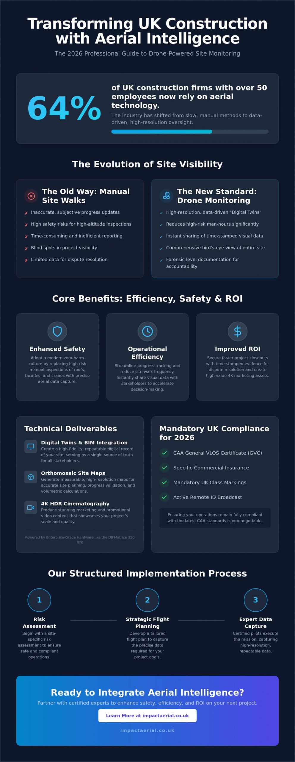
64% of UK construction firms with over 50 employees now rely on aerial technology to oversee their projects. It’s a massive shift from just a few years ago, driven by the need to replace slow, manual reporting with something more reliable. You’ve likely felt the frustration of inaccurate progress updates or the inherent risks of sending staff into high-altitude zones for basic inspections. Professional construction site monitoring with drones eliminates these bottlenecks by providing a high-resolution, bird’s-eye view that manual site walks simply can’t match.
In this 2026 professional guide, you’ll discover how high-tier drone data transforms site safety, streamlines progress tracking, and secures a better ROI for your UK projects. We’ll walk you through the latest CAA compliance standards, including mandatory UK class markings and Remote ID requirements that took full effect this year. You’ll also learn how integrating data from enterprise-grade hardware like the DJI Matrice 350 RTK leads to faster project closeouts and provides the time-stamped documentation you need for dispute resolution. From reducing site-walk frequency to building accurate digital twins, we’re covering the technical standards that define modern site management.
Key Takeaways
- Learn how the transition from manual site walks to repeatable digital twin creation provides a more accurate, high-resolution record of project development.
- Understand how professional construction site monitoring with drones reduces high-risk man-hours by replacing manual inspections of cranes and roofs with precise aerial data.
- Explore the technical deliverables that drive project value, ranging from high-resolution 4K HDR marketing cinematography to measurable orthomosaic site maps.
- Identify the critical legal requirements for 2026, including the necessity of CAA GVC certification and specific insurance to ensure your operations remain fully compliant.
- Discover the structured approach to implementing aerial monitoring, beginning with site-specific risk assessments and strategic flight planning by certified experts.
What is Construction Site Monitoring with Drones?
Modern project management has moved beyond the limitations of the handheld camera. Construction site monitoring with drones is the professional practice of using sophisticated aerial platforms to capture repeatable, high-resolution data across the entire lifecycle of a build. By 2026, the UK industry has transitioned away from subjective manual site walks toward the creation of high-fidelity digital twins. These digital models provide a single source of truth for every stakeholder involved. To understand the technology behind these platforms, it’s helpful to look at the broader definition of What is an Unmanned Aerial Vehicle (UAV)? as these aircraft are the engines of this data revolution.
To better understand this concept, watch this helpful video:
The Evolution of Site Visibility
Traditional ground-level photography often fails to capture the full scale of a development, leaving blind spots in progress reports. High-resolution 4K HDR aerial imagery provides a comprehensive perspective that replaces qualitative “looks good” updates with quantitative data points. Every flight generates time-stamped documentation, allowing project managers to verify timelines with absolute precision. This level of visibility isn’t a luxury; it’s a baseline requirement for modern UK contract management. We’ve moved from simple snapshots to data-centric processes where every pixel serves as a record of progress.
Types of Monitoring Workflows
Effective monitoring follows a structured cadence tailored to the project’s complexity. Periodic updates, typically conducted on a weekly or monthly basis, keep off-site stakeholders informed without requiring frequent, time-consuming site visits. Using construction site monitoring with drones for these updates ensures that every stakeholder has access to the same high-resolution visual record. On-demand inspections address specific structural or safety concerns as they arise, such as verifying crane clearances or inspecting high-altitude facade elements. Many firms also integrate strategic drone property surveys during the pre-construction phase to establish accurate site baselines.
From initial site clearance to final punch-list verification, the use of drones ensures that every phase of construction is documented with forensic detail. This meticulous approach reduces the frequency of site walks and provides the high-tier evidence needed for dispute resolution. It’s about providing psychological comfort to clients while delivering tangible, data-driven benefits to the bottom line.
Key Benefits: Efficiency, Safety, and Project ROI
Professional construction site monitoring with drones delivers measurable improvements to operational safety and financial performance. By replacing manual roof and crane inspections, firms significantly reduce high-risk man-hours. This shift doesn’t just save time; it protects lives by keeping personnel on the ground while high-resolution sensors capture every detail from above. Stakeholder communication also accelerates through cloud-based platforms, allowing site managers to share time-stamped visual data with off-site teams instantly. This transparency helps identify logistical bottlenecks, such as equipment positioning or material delivery delays, before they impact the project’s critical path.
Health and Safety Improvements
Adopting aerial technology is a cornerstone of a modern zero-harm culture. Traditional visual checks often require expensive scaffolding or risky ladder use, both of which are eliminated through precise, repeatable flight paths. Drones identify potential hazards like unsecured materials or perimeter breaches that are easily missed from ground level. This proactive approach is supported by university research on drone safety, which highlights how UAVs perform dangerous tasks more efficiently than human inspectors. Integrating drones and surveying into your safety protocols ensures that high-altitude inspections are conducted without exposing staff to unnecessary danger.
Calculating the Return on Investment
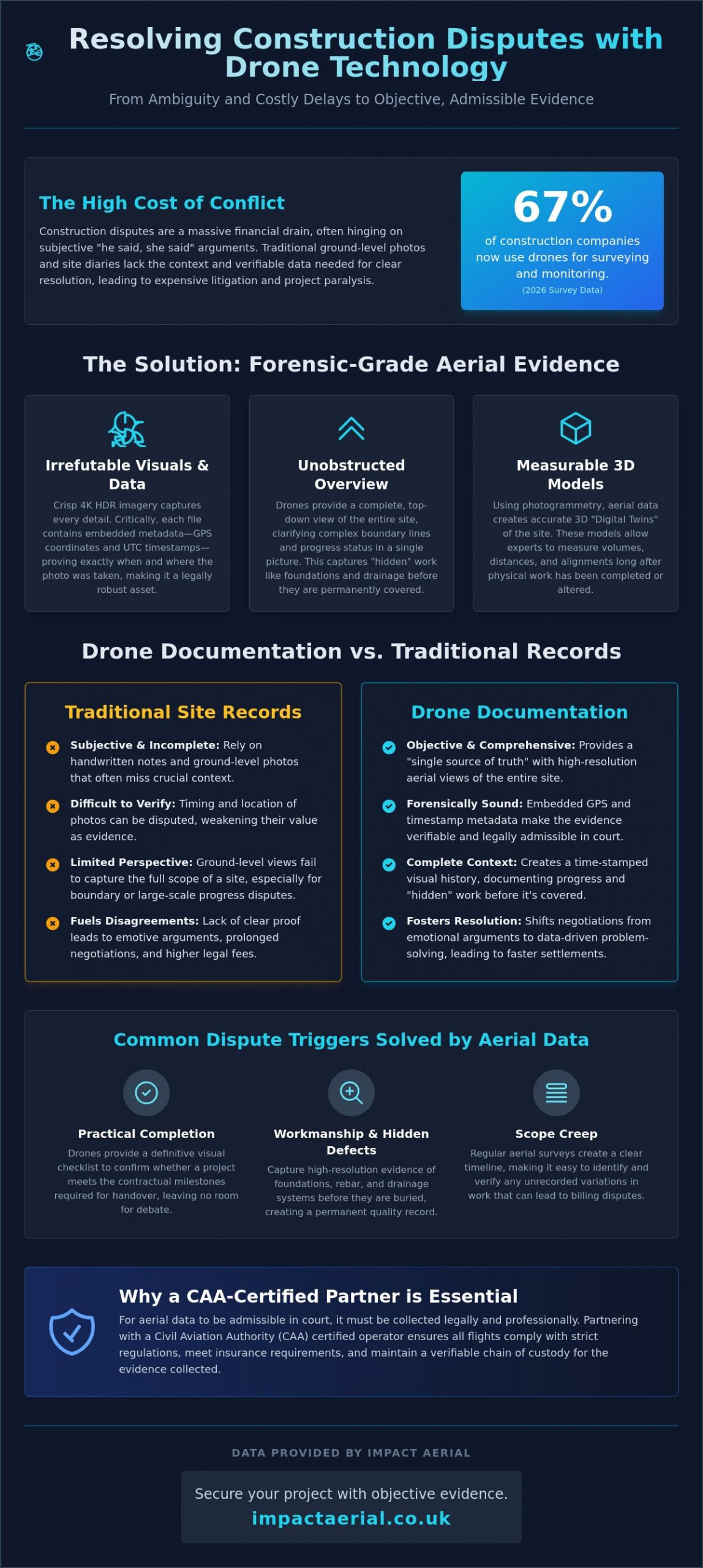
The financial benefits of construction site monitoring with drones are concrete and immediate. UK construction firms report time savings of up to 20-30% on surveying and progress tracking tasks. One housing development project recently saved £20,000 by opting for drone surveying over traditional methods. These savings stem from more accurate stockpile measurements for material management and the reduction of expensive rework through early error detection. High-resolution documentation also provides an indisputable record for dispute resolution, protecting your firm from unfounded claims. Drone data prevents costly project delays by identifying deviations from the site plan in real-time. For developers looking to secure these efficiencies, partnering with an expert for professional construction monitoring is the most direct route to maximizing site ROI.
Beyond simple progress tracking, drones enhance site security and asset tracking across large-scale developments. Automated flight paths can monitor the movement of high-value machinery and materials, ensuring that site assets are exactly where they should be. This level of oversight provides reassurance to both investors and project managers that the site is being managed with meticulous precision.
Technical Deliverables: From 4K Video to BIM Integration
Professional construction site monitoring with drones produces a suite of high-tier technical deliverables that extend far beyond simple photography. For project managers, the primary value lies in the precision and repeatability of the data captured. High-resolution 4K HDR cinematography provides crystal-clear visual records for both internal progress tracking and external stakeholder updates. While these visuals are vital for documentation, they also serve a secondary purpose in high-end marketing, showcasing the scale and quality of the build to potential investors or clients in a way that ground-level shots cannot match.
Orthomosaic mapping is another critical output, involving the stitching together of hundreds of aerial images to create a single, measurable, top-down map of the entire site. These maps are georeferenced, allowing teams to take accurate measurements of distances and areas directly from the digital file. For projects utilizing Building Information Modelling (BIM), 3D point clouds and mesh models allow for a direct comparison between the “as-built” progress and the original architectural designs. This integration ensures that any deviations are caught early, maintaining the integrity of the project design and preventing expensive remedial work later in the schedule.
Progress Reporting Formats
Effective communication depends on how data is presented to decision-makers. We provide side-by-side “Then vs. Now” visual comparisons that clearly illustrate development milestones during board meetings or client briefings. Annotated imagery allows site managers to highlight specific issues, such as structural concerns or material misplacements, and share them directly with contractors for immediate action. Many clients also leverage our construction site monitoring with drones alongside specialized aerial filming drone techniques. This combination delivers cinematic marketing assets that capture the project’s evolution with an aspirational quality that enhances the brand’s professional image.
Advanced Data Collection
Beyond visual updates, drones equipped with thermal sensors identify heat loss or moisture ingress in new builds before the final handover. This technical oversight is essential for meeting modern UK building standards and ensuring long-term structural health. For earthworks and excavation, volumetric analysis provides precise data on stockpile volumes and soil movement, which is vital for accurate material management.
The accuracy of these deliverables relies heavily on the use of DJI Enterprise grade hardware. Utilizing platforms like the Matrice 350 RTK ensures that topographic data is captured with centimetre-level precision, which is necessary for drainage assessments and initial site planning. By moving from qualitative assessments to quantitative data points, firms gain a level of site control that provides both psychological comfort and tangible financial benefits.
UK Compliance: Why CAA GVC and Insurance Matter
Legal compliance is the foundation of any professional aerial operation. For construction site monitoring with drones, using an uncertified pilot isn’t just a safety risk; it’s a significant legal liability for the site manager. As of January 1, 2026, the transitional arrangements for UK drone operations have officially ended, making it mandatory for operators to adhere to a stricter framework involving UK class markings and Remote ID. Operating without the correct CAA permissions or valid commercial insurance can lead to heavy fines and the immediate halt of site activities. Ensuring your drone partner is fully vetted provides the psychological comfort that your project remains on the right side of the law.
Navigating CAA Regulations
Understanding the distinction between different certifications is vital for project planning. While the A2 Certificate of Competence (A2 CofC) allows for basic operations, the General Visual Line of Sight Certificate (GVC) is the industry standard for complex construction environments. The GVC is required for pilots seeking Operational Authorisation from the CAA, which is essential when flying enterprise-grade hardware in congested areas. A professional pilot handles all flight permissions, including navigating restricted UK airspace and managing the £524 CAA application fee for specific authorisations. For a more detailed breakdown of these requirements, consult our comprehensive drone license guide.
Complex urban projects, such as those in Birmingham city centre, often require an Operational Safety Case (OSC). This advanced permission allows pilots to operate closer to people and structures than standard rules permit, which is often necessary for high-resolution facade inspections or tight site perimeters. Managing these permissions requires a meticulous approach to risk assessment that only a qualified specialist can provide.
Insurance and Liability
Standard recreational drone insurance is entirely invalid for construction site monitoring with drones. Commercial operations require specialist policies that comply with EC 785/2004 regulations. We recommend a minimum of £5m public liability insurance for sub-20kg drones, though larger developments often require up to £10m to meet corporate risk requirements. This coverage protects the site manager from vicarious liability in the event of an incident, ensuring that the financial burden doesn’t fall on the construction firm. Professional indemnity insurance is essential to cover the accuracy and reliability of the digital data and topographic surveys provided to the project team. To ensure your next project is managed by a compliant and fully insured team, book a professional site consultation with our GVC-certified pilots today.
By prioritizing vetted contractors who understand the 2026 regulatory landscape, you eliminate the guesswork from aerial data collection. It’s about more than just capturing images; it’s about maintaining a compliant, safe, and professional site environment that stands up to regulatory scrutiny.
Implementing Drone Monitoring with Impact Aerial
Integrating professional construction site monitoring with drones into your workflow is a structured process designed to minimize disruption while maximizing data quality. We follow a methodical four-step implementation plan to ensure every flight delivers tangible value to your project team. This systematic approach allows site managers to focus on the build while we handle the complexities of aerial data collection and regulatory compliance.
- Step 1: Initial Consultation. We begin by defining your monitoring frequency and specific data needs. Whether you require weekly progress updates for stakeholders or high-fidelity 3D models for BIM comparison, we tailor the mission to your project’s critical path.
- Step 2: Risk Assessment and Flight Planning. Our GVC-certified pilots conduct a comprehensive site risk assessment. We manage all necessary flight permissions and coordinate with local authorities to ensure safe operations in complex UK airspace.
- Step 3: Precision Data Capture. Using commercial-grade DJI Enterprise drones, we capture high-resolution imagery and topographic data. Our hardware ensures centimetre-level accuracy, which is essential for measurable site maps and volumetric analysis.
- Step 4: Post-Production and Delivery. Raw data is processed into actionable site insights. We deliver high-tier visual reports and data files that are ready for immediate use in board meetings or project management software.
Why Outsource Your Site Monitoring?
While some firms consider building an internal team, 77% of UK construction companies prefer to outsource their aerial operations to specialists. This decision avoids the significant capital expenditure required to purchase and maintain DJI Matrice or Mavic Enterprise fleets. Outsourcing also removes the ongoing burden of pilot training and the administrative weight of managing CAA Operational Authorisations. By partnering with a specialist, you ensure that your construction site monitoring with drones is performed to the highest technical standards. You gain access to professional post-production services that turn raw footage into sophisticated, client-ready reports without the internal overhead or equipment depreciation risks.
Our Professional Standards
Based in Birmingham, we serve the West Midlands and projects across the UK with a meticulous focus on safety and precision. Our operations are built on a foundation of strict adherence to safety protocols and the latest 2026 regulatory standards. We understand that site managers need reliable data for dispute resolution and accurate progress tracking. If you’re ready to enhance your project oversight with expert aerial data, contact Impact Aerial for a tailored construction monitoring quote and discover how our professional oversight can protect your site’s ROI.
Securing the Future of Your Site Oversight
The transition toward data-centric project management is no longer a future prospect; it’s the current standard for competitive UK developers. By integrating professional construction site monitoring with drones, you replace subjective reporting with a high-resolution, time-stamped record of every build phase. This approach doesn’t just streamline stakeholder communication; it provides the forensic detail required for dispute resolution and high-altitude safety inspections that were previously impossible to conduct without significant risk.
Success in this specialized field requires more than just hardware. It demands meticulous adherence to the latest CAA regulations and a commitment to operational excellence. Our team provides the psychological comfort of knowing your project is in expert hands, utilizing a DJI Enterprise fleet capable of high-end 4K HDR output. With CAA GVC certified pilots and £5m commercial liability insurance as our baseline, we ensure your site remains compliant and secure while delivering actionable insights that drive project ROI. Request a Professional Construction Site Monitoring Quote to see how we can transform your site visibility. We look forward to helping you achieve faster project closeouts through unparalleled site oversight.
Frequently Asked Questions
Do I need a special permit for drone monitoring on my construction site?
Commercial construction site monitoring with drones requires Operational Authorisation from the Civil Aviation Authority (CAA). This isn’t a simple permit but a legal requirement based on a pilot’s General Visual Line of Sight Certificate (GVC). For complex urban sites, a specialist may also need an Operational Safety Case (OSC) to fly closer to people or buildings than standard regulations allow.
How much does construction site monitoring with drones cost in the UK?
Pricing for aerial monitoring is determined by the project’s complexity, the frequency of flights, and the specific technical deliverables required. A one-off site survey has a different cost structure than a year-long weekly progress tracking contract. We provide tailored quotes that reflect the specific hardware needs and data processing requirements of your development to ensure maximum value.
Can drones fly in rain or high winds on a construction site?
Modern enterprise drones like the DJI Matrice 350 RTK are designed with IP55 weather resistance and can operate in moderate rain. However, high winds exceeding 12 metres per second typically require a grounded flight for safety. Our pilots monitor local METAR data to ensure every mission is conducted within the safe operational limits of the aircraft and the sensors.
What is the difference between an orthomosaic map and a standard aerial photo?
A standard aerial photo is a single perspective snapshot that contains geometric distortion. An orthomosaic map is created by stitching hundreds of images together and correcting them for perspective and scale. This results in a georeferenced, top-down map where every pixel is accurate. It allows your team to take precise measurements of distances and areas directly from the digital file.
How often should a drone monitor a construction site for progress tracking?
Monitoring frequency depends on the pace of the build and your reporting requirements. Most UK projects opt for weekly or bi-weekly flights to maintain a consistent record for stakeholder updates. During high-activity phases, such as earthworks or structural steel erection, more frequent flights might be necessary to capture the rapid changes on the project’s critical path.
Is drone monitoring compliant with GDPR when flying near residential areas?
Professional drone operations are fully compliant with GDPR and UK data protection laws. We conduct Privacy Impact Assessments before flights and use post-production techniques to blur faces, house windows, and vehicle registration plates. This ensures that while we capture essential site data, the privacy of the surrounding community is meticulously protected throughout the monitoring process.
What insurance coverage should a professional drone pilot have for construction?
A professional pilot must hold commercial public liability insurance that is compliant with EC 785/2004. For most UK construction sites, a minimum of £5m coverage is expected, though larger infrastructure projects often require £10m. This insurance protects the site manager and the developer against third-party property damage or injury claims, providing essential financial security.
Can drone data be integrated directly into BIM software like Revit or AutoCAD?
Aerial data is easily integrated into Building Information Modelling (BIM) workflows. We provide georeferenced 3D point clouds and orthomosaics in industry-standard formats like .LAS, .OBJ, and .GeoTIFF. These files can be imported directly into Revit or AutoCAD. This allows for a precise side-by-side comparison between the as-built site and the original architectural designs to catch deviations early.