
Onboarding a Drone Services Company: The Professional Buyer’s Guide

Did you know that 67% of construction firms now use drones for site monitoring, yet many procurement teams still treat these high-tech aerial assets like standard sub-contractors? When you’re onboarding a drone services company, the difference between a successful deployment and a legal nightmare often comes down to the quality of your vetting process. It’s common to feel uncertain about whether aerial data truly outperforms traditional methods, or to worry about the operational risks of having a drone over a live site.

We agree that the stakes are high. One oversight regarding CAA regulations or insurance can lead to significant liability. This guide is designed to help you master the corporate procurement process for drone services, ensuring full compliance and robust risk management. You’ll learn how to verify certifications, confirm specific insurance coverage, and ensure seamless data integration. We’ll provide a comprehensive checklist for vendor vetting, giving you the assurance that your provider is a meticulous, safety-conscious specialist capable of delivering high-tier results without disrupting your daily workflow.

Key Takeaways

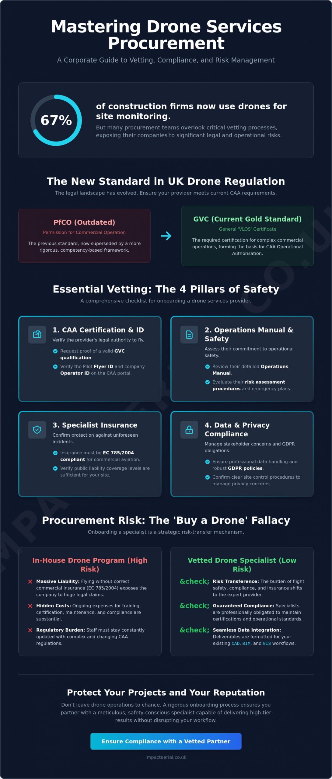
  • Understand the critical shift from PfCO to the GVC framework to ensure your drone provider meets current CAA regulatory standards for commercial operations.
  • Master the strategic steps for onboarding a drone services company, focusing on rigorous legal vetting and operational alignment for complex corporate projects.
  • Learn to define high-value deliverables through a clear Statement of Work that supports seamless data integration with existing CAD, BIM, and GIS workflows.
  • Identify the essential insurance requirements, such as EC 785/2004 compliance, that protect your organization from liability and unforeseen site disruptions.
  • Discover how to proactively manage stakeholder concerns regarding GDPR and privacy through robust site control procedures and professional data handling.

What is Professional Onboarding for Drone Services?

The formal process of onboarding a drone services company is a rigorous procurement procedure that moves beyond simply hiring a pilot. It represents a structured alignment of vetting, legal verification, and operational integration. For Tier 1 contractors and ISO-compliant organisations, this process is essential for maintaining safety standards and mitigating corporate liability. It marks the definitive shift from hiring amateur photography enthusiasts to partnering with technical consultants focused on high-precision commercial data collection. This professional approach ensures that aerial technology serves as a reliable tool for business intelligence rather than a source of operational risk.

To better understand this concept, watch this helpful video:

The industry has undergone significant regulatory changes, specifically the transition from the old Permission for Commercial Operation (PfCO) to the current CAA GVC framework. This evolution reflects a more structured approach to Global drone regulations, prioritising competency and risk assessment over simple flight hours. In a market where 67% of construction firms now use drones for site monitoring, professional onboarding ensures that your data is accurate, legally obtained, and ready for integration into business workflows. This meticulous vetting process provides the psychological comfort and tangible benefits required by modern project managers.

The Legal Framework: CAA GVC and A2 CofC

A CAA GVC certified pilot is the gold standard for complex commercial work. While the A2 Certificate of Competency (A2 CofC) allows for flights in less restrictive environments, it often lacks the robust safety frameworks required for industrial or construction site monitoring. The GVC provides the necessary foundation for obtaining an Operational Authorisation, which is the specific legal “permission to fly” granted by the CAA to commercial entities for complex missions. This certification ensures the operator has undergone rigorous theoretical and practical assessments tailored to professional environments where precision is non-negotiable.

Why “Just Buying a Drone” is a Procurement Risk

It’s tempting for businesses to purchase hardware internally, but this often creates significant procurement risks. While the cost of professional drones has decreased, the expense of training, maintaining compliance, and securing commercial-grade insurance remains high. Internal staff flying without specific commercial liability insurance (EC 785/2004 compliant) exposes the company to massive legal liability if an incident occurs. Onboarding a drone services company acts as a strategic risk-transfer mechanism. By partnering with a specialist, you shift the burden of regulatory compliance, equipment maintenance, and flight safety to an expert who is fully insured and certified to operate in high-risk zones, ultimately protecting your organization’s reputation and bottom line.

Essential Compliance Vetting: The 4 Pillars of Safety

When you are onboarding a drone services company, your first priority is a rigorous vetting of their legal credentials. This isn’t just about ticking boxes; it’s about verifying that the operator has the technical competency and legal authority to fly in complex environments. Start by requesting the pilot’s Flyer ID and the company’s Operator ID. You can verify these details directly through the Civil Aviation Authority (CAA) portal. As of 2026, an Operator ID is mandatory for any drone with a camera weighing 100g or more. This verification ensures that the provider is registered and accountable under current UK law, providing the first layer of protection for your project.

The second pillar involves reviewing the provider’s Operations Manual and safety record. A professional operator will have a detailed manual that outlines their specific safety protocols, risk assessment procedures, and emergency contingency plans. This document is a requirement for obtaining an Operational Authorisation from the CAA. Don’t hesitate to ask for evidence of past safety performance or site-specific risk assessments. A company that is transparent about its safety culture is far more likely to integrate into your on-site operations without causing disruption. This level of meticulousness is what separates a technical consultant from a casual operator.

Commercial Drone Insurance: Why £5m Liability Matters

While the minimum insurance requirement for commercial drone operations in the UK is governed by Regulation (EC) 785/2004, most Tier 1 contractors and property managers require a higher standard. A £5m public liability policy has become the industry benchmark for construction and commercial property sites. This coverage is vital because it protects your organization against claims related to property damage, personal injury, and accidental privacy breaches. If you’re commissioning technical data, ensure the provider also carries professional indemnity insurance. This protects you if a decision made based on their survey data leads to financial loss. Verifying these professional insurance standards is a non-negotiable step in the procurement process for any high-value asset manager.

Hardware Standards: 4K HDR and Thermal Capabilities

The choice of equipment is a key indicator of a provider’s professionalism. Consumer-grade drones often lack the sensor quality and stability required for high-stakes commercial drone surveys. Professional operators typically utilize DJI Enterprise models or equivalent commercial hardware. These systems offer 4K HDR video for marketing purposes and high-resolution sensors that capture the level of detail needed for technical inspections. For specialized projects like PV solar farm surveys or roof inspections, thermal imaging capabilities are essential. High-end thermal sensors can detect heat signatures and anomalies that are invisible to the naked eye, providing actionable intelligence that traditional methods simply cannot match. Confirming that your partner uses hardware with UK class marks (UK0 to UK6) also ensures they are compliant with the latest 2026 hardware regulations.
Onboarding a Drone Services Company: The Professional Buyer’s Guide

Operational Integration: Aligning Drone Data with Project Goals

Successful onboarding a drone services company requires a clear transition from compliance verification to operational execution. This stage is defined by the creation of a robust Statement of Work (SoW), which acts as the technical blueprint for the entire engagement. A well-structured SoW must explicitly define the nature of the deliverables, distinguishing between RAW data for technical analysis and polished, edited assets for stakeholder presentations. Establishing these parameters early prevents scope creep and ensures that the aerial intelligence gathered aligns perfectly with your specific business objectives, whether you’re monitoring a multi-year construction project or conducting a one-off structural survey.

Effective integration also depends on setting clear communication protocols for site-specific flight windows. Professional operators work around your schedule to minimize site disruption, often coordinating with site managers to identify periods of low activity. For long-term projects, such as weekly construction site monitoring, a consistent data collection frequency is established to create a reliable chronological record of progress. This methodical approach allows project managers to overlay aerial data directly into existing CAD, BIM, or GIS software, transforming visual assets into measurable technical insights that drive informed decision-making.

From Raw Footage to Actionable Intelligence

The value of professional drone services lies in the post-production process. While a standard pilot might provide basic files, a technical specialist transforms raw data into actionable intelligence. For marketing and corporate communications, aerial filming and photography involves sophisticated color grading and editing to produce cinematic-quality video. In more technical sectors, 3D photogrammetry and point clouds are generated to create high-precision digital twins of land or structures. These models are essential for land surveying and volume calculations. Additionally, virtual tour creation provides property professionals and advertising agencies with immersive, 360-degree perspectives that traditional photography cannot replicate.

Site Access and Pre-Flight Planning

A meticulous operator handles all the logistical complexities of site access long before the drone leaves the ground. This includes conducting a Site-Specific Risk Assessment (SSRA) to identify hazards like overhead power lines or public footpaths. Gaining landowner permission and notifying local authorities are standard procedures for a compliant provider. In restricted airspace, the operator will manage the “Notice to Airmen” (NOTAM) process, ensuring that other airspace users are aware of the drone activity. This level of pre-flight planning ensures that operations are conducted safely and legally, providing you with the reassurance that your project is in expert hands.

Risk Management and Privacy: Addressing Stakeholder Concerns

Effective risk management is the cornerstone of professional aerial operations. When you are onboarding a drone services company, you must look beyond the flight itself and evaluate how the provider manages the psychological and physical concerns of your stakeholders. Addressing the fear of “drone crashes” is a primary step in this process. Professional operators utilize hardware with significant technical redundancy, including dual batteries, multiple IMUs, and sophisticated obstacle avoidance sensors. These systems, combined with the pilot’s advanced flight skills, ensure that the risk of equipment failure is minimized. This technical approach provides the reliability that corporate clients expect when operating in high-value or sensitive environments.

Weather-related delays are an inherent part of aviation, but they shouldn’t compromise your project timelines. A specialist operator monitors meteorological data days in advance and maintains flexible scheduling to capitalize on safe flight windows. By establishing clear communication protocols during the onboarding phase, you can ensure that any weather-related adjustments are handled without impacting ground-level operations. This proactive management allows for a seamless integration of drone technology into your existing project schedule, maintaining momentum while prioritizing safety above all else.

GDPR and Data Privacy in Aerial Photography

Privacy is a significant concern for urban projects where drones may inadvertently capture images of the public. A professional pilot understands their legal responsibility to protect individual privacy by blurring faces and vehicle number plates in any non-consensual footage. For large-scale urban developments, conducting a Data Protection Impact Assessment (DPIA) is a critical step in the onboarding process. This assessment identifies potential privacy risks and outlines the mitigation strategies used to protect data subjects. Our team ensures that all captured data is stored on encrypted, secure servers with strict access controls to maintain the highest standards of digital security.

Mitigating Operational Disruption

One of the most significant benefits of aerial technology is its “non-contact” nature. Unlike traditional methods that require scaffolding, cranes, or cherry pickers, drones can inspect assets from a safe distance without touching the structure. This eliminates the need for expensive and disruptive physical access equipment. The efficiency of rapid deployment is clear when completing a drone roof survey, which can often be finished in hours rather than days. This speed significantly reduces the time spent on-site, allowing your team to continue their work without interruption.

To ensure zero impact on your daily operations, professional operators coordinate closely with site managers to establish robust “cordon and control” procedures. These involve securing take-off and landing zones and ensuring that flight paths avoid active work areas where possible. This meticulous planning ensures that the drone remains an unobtrusive tool for data collection. If you are ready to enhance your site safety and data accuracy, contact Impact Aerial today to discuss your specific project requirements.

Partnering with Impact Aerial: Your UK Onboarding Solution

Impact Aerial provides a comprehensive solution for corporate clients looking to integrate aerial intelligence into their operations. Our Birmingham based team delivers nationwide coverage, ensuring that high tier filming and surveying services are accessible across the UK. When you are onboarding a drone services company, the complexity of managing multiple vendors can be overwhelming. We simplify this by providing full project management, guiding you from the initial technical consultation through to the final post production delivery. Our commitment to CAA GVC certified excellence ensures that every flight is conducted with the highest regard for safety and regulatory compliance.

For Tier 1 contractors and large scale property developers, our £5m commercial liability insurance provides the necessary psychological comfort and legal protection required for high stakes projects. This level of coverage, combined with our meticulous adherence to safety protocols, makes us a trusted specialist for organisations that value external validation and industry standards. We don’t just fly drones; we provide a risk mitigated service that delivers tangible business benefits. By choosing a partner with established credentials, you ensure that your aerial data collection is both legally sound and technically superior.

Our Technology Stack: DJI Enterprise and 4K HDR

We utilise a commercial grade technology stack centred around DJI Enterprise hardware. These systems provide the superior stability and image quality needed for 4K HDR cinematic filming and high resolution technical inspections. Our specialised thermal surveying capabilities are particularly valuable for PV solar farm assessments and commercial property surveys, where detecting heat anomalies is critical for asset maintenance. Beyond data collection, our in house post production suite allows us to create immersive virtual tours and high end marketing films that showcase your projects from unique and aspirational perspectives. This end to end capability ensures that the data we capture is transformed into actionable intelligence for your stakeholders.

Streamlined Procurement for Corporate Clients

We understand that procurement departments need efficiency and clarity. To speed up your vendor onboarding process, we provide all essential compliance documentation, including our Operations Manual, insurance certificates, and pilot credentials, upfront. This transparency reduces the administrative burden on your team and ensures a faster path to project commencement. Our extensive experience working across the property, construction, and advertising sectors allows us to align our services with your specific industry requirements and safety standards. Contact Impact Aerial today to discuss your project requirements and discover how our professional drone services can transform your data collection workflow.

Securing Your Project’s Aerial Future

Mastering the process of onboarding a drone services company transforms a complex regulatory challenge into a streamlined operational advantage. By prioritizing CAA GVC certification and verifying robust insurance standards, you protect your organization from liability while gaining access to high-precision data. We’ve explored how aligning technical deliverables with your existing CAD or BIM workflows ensures that aerial intelligence becomes a functional part of your project management strategy. This structured approach moves your procurement beyond simple photography and into the realm of professional technical consultancy.

Impact Aerial is ready to support your next mission with our team of CAA GVC Certified Pilots and £5m commercial liability insurance. Based in Birmingham, we provide comprehensive UK-wide coverage for filming and surveying projects of any scale. We handle the entire project lifecycle, from initial risk assessments to final post-production, so you can focus on your core business goals. Request a professional drone services quote from Impact Aerial to begin your next project with confidence. We look forward to helping you achieve a new perspective on your operations.

Frequently Asked Questions

What certifications should I look for when onboarding a drone company?

You should prioritize the General Visual Line of Sight Certificate (GVC) and a valid Operational Authorisation from the CAA. These credentials confirm the pilot has undergone rigorous training and has the legal permission to conduct complex commercial flights. Additionally, verify their Operator ID and Flyer ID through the CAA portal to ensure they are registered under the latest 2026 UK drone regulations.

How much public liability insurance does a professional drone pilot need?

While the legal minimum is set by Regulation (EC) 785/2004, most corporate clients and Tier 1 contractors require a minimum of £5 million in public liability insurance. This level of coverage protects against property damage, personal injury, and privacy breaches on industrial or construction sites. Always confirm that the policy is specifically tailored for commercial drone operations rather than general business activities.

Can a drone company fly in restricted airspace like London or near airports?

Yes, professional operators can fly in restricted zones by obtaining specific permissions from National Air Traffic Services (NATS) or local Air Traffic Control (ATC). This process involves submitting a flight plan and coordinating closely with authorities to ensure safety. When onboarding a drone services company for projects in cities like London, ensure they have experience managing these complex coordination procedures.

Do I need to notify the police before a drone flight on my property?

You typically don’t need to notify the police for standard commercial drone operations on private property. The primary requirement is obtaining permission from the landowner and ensuring the flight complies with CAA safety distances. However, for high profile locations or large public events, a professional operator might inform local authorities as a courtesy to prevent unnecessary security concerns.

What is the difference between a PfCO and a GVC for commercial drones?

The PfCO (Permission for Commercial Operation) is a legacy qualification that has been phased out in favor of the GVC (General Visual Line of Sight Certificate). The GVC is the current professional standard required to apply for an Operational Authorisation from the CAA. It reflects updated safety protocols and hardware classifications that came into effect to align with modern aviation standards.

How long does the onboarding process typically take for a new drone vendor?

The process of onboarding a drone services company usually takes between three to ten working days depending on the depth of your internal compliance checks. This timeframe allows for the verification of insurance, CAA certifications, and the review of the operator’s safety manual. Providing clear procurement requirements early can significantly speed up this transition and move your project into the operational phase faster.

What data formats will I receive after a drone survey or filming session?

You will receive industry standard formats tailored to your specific software requirements. For aerial filming, this typically includes 4K MOV or MP4 files and high resolution JPG or RAW images. For technical surveys, data is delivered in formats like GeoTIFF for maps, LAS or OBJ for 3D point clouds, and PDF for detailed inspection reports that integrate into CAD or BIM software.

Is a drone survey really cheaper than traditional scaffolding?

Yes, drone surveys are significantly more cost effective, often reducing inspection expenses by over 50% compared to traditional scaffolding or cherry pickers. Aerial inspections eliminate the high costs of equipment rental, labor for assembly, and site downtime. A drone can complete a comprehensive roof survey in hours rather than days, providing high resolution data without the physical risks of working at height.

Beyond the Price Tag: Justifying the Cost of Professional Drone Services in 2026

What if the £300 “bargain” aerial survey you booked actually costs your firm £50,000 in HSE fines and three weeks of project delays? It’s a scenario we see too often when procurement teams prioritise the lowest quote over technical competence. You likely feel the pressure of justifying the cost of drone services to stakeholders who still view UAVs as expensive toys rather than essential industrial tools. It’s difficult to explain to senior management why a CAA GVC certified pilot with £10 million in commercial liability insurance is worth five times the price of a local hobbyist.

We understand that you need more than just “nice photos”; you need actionable data that stands up to scrutiny. This article provides a clear framework for calculating ROI through high-accuracy photogrammetry and risk mitigation. You’ll discover how professional aerial data reduces site inspection times by 70% and provides the legal “peace of mind” required for major UK infrastructure projects in 2026. We’ll break down exactly how to move from a price-based decision to a value-driven investment that protects your bottom line.

Key Takeaways

  • Understand how 2026 advancements in AI-driven analysis and HDR sensors have transitioned aerial deliverables from aesthetic shots into mission-critical technical data.
  • Decode the “Iceberg Effect” of professional pricing, justifying the cost of drone services through the deployment of elite enterprise fleets and robust safety frameworks.
  • Learn how to secure a measurable ROI by using preventative £500 surveys to identify faults that could lead to £50,000 in structural repair costs.
  • Mitigate legal liability and ensure data integrity by prioritising CAA GVC certified operators who provide the necessary peace of mind for complex commercial projects.
  • Discover the strategic advantage of a full-service partnership that manages the entire workflow from regulatory consultation to high-quality post-production.

The Strategic Shift: Why Drones Are Now an Operational Necessity

The commercial landscape for unmanned aerial vehicles (UAVs) has moved far beyond the era of simple “eye in the sky” photography. Since 2022, we’ve seen a decisive transition where aerial data has become a foundational operational necessity for tasks across the UK’s construction, infrastructure, and property sectors. By 2026, the arrival of sophisticated AI-driven analysis and High Dynamic Range (HDR) sensors has redefined what clients expect from a flight. It’s no longer about capturing a pleasing image; it’s about harvesting actionable intelligence that informs multi-million pound decisions.

Asset managers and site engineers now rely on these technical outputs to replace slower, riskier manual processes. Justifying the cost of drone services is a simple matter of comparing the precision of a UAV with the inherent fallibility of ground-based surveys. In the UK construction industry, where 30% of work is often attributed to rework, the ability to identify a misalignment early can save a project upwards of £45,000 in remedial costs. Our fleet of DJI Enterprise drones provides the high-fidelity data required to spot these discrepancies long before they become structural liabilities.

The value of drone deployment lies in the mitigation of human risk and the elimination of expensive temporary works. When you remove the need for a surveyor to work at height, you don’t just save time; you eliminate the primary cause of workplace accidents. This safety-first approach, backed by our CAA GVC certification and comprehensive commercial liability insurance, provides the peace of mind that modern corporate compliance demands.

From Visuals to Verifiable Data

The distinction between a standard aerial photo and a georeferenced data point is the difference between a snapshot and a scientific record. We use photogrammetry and LiDAR to transform thousands of individual images into centimetre-accurate 3D digital twins. These models integrate seamlessly into Building Information Modelling (BIM) workflows, allowing for a 100% accurate comparison between “as-built” progress and the original architectural design. Thermal mapping sensors now detect moisture ingress or heat loss invisible to the naked eye, identifying failing insulation or flat roof leaks that would otherwise remain hidden until significant damage occurs. This level of data-gathering is what makes drones indispensable for modern asset management.

The Time-Saving Factor in 2026

Time is the most expensive variable on any project site. A traditional manual inspection of a 50,000 square foot commercial warehouse roof typically requires a week of planning, two days of scaffolding or cherry picker hire, and a team of three specialists. This process can easily cost £4,000 or more. A professional drone pilot can complete a more comprehensive, higher-resolution survey in a single 20-minute flight. By 2026, automated flight paths allow us to repeat these missions with absolute consistency. This rapid deployment enables proactive maintenance cycles, which have been shown to reduce long-term repair budgets by an average of 22% by catching minor defects before they escalate. Justifying the cost of drone services becomes a logical choice when a single morning of aerial work replaces a week of site disruption.

  • Manual Inspection: 48+ hours, high risk, £3,500 – £5,000 average cost.
  • UAV Inspection: 20-60 minutes, zero risk to personnel, significantly lower cost.
  • Data Output: 4K HDR video, 45MP stills, and centimetre-accurate 3D point clouds.

Decoding the Quote: What You Are Actually Paying For

When you review a professional quote, you’re seeing the tip of a very large iceberg. The 20 minutes an aircraft spends in the air represents less than 15% of the total resource allocation for a project. Justifying the cost of drone services requires looking beneath the surface at the capital investment and technical infrastructure that ensures a successful delivery. You aren’t just paying for a flight; you’re paying for a data-gathering operation that requires high-end hardware, specialist software, and years of operational experience.

The gap between consumer-grade equipment and a professional DJI Enterprise fleet is vast. While a high-street drone might cost £1,200, a commercial M350 RTK setup with high-resolution sensors often exceeds £15,000 per unit. These enterprise systems provide the stability, wind resistance, and sub-centimetre GPS accuracy required for industrial surveys. Professional firms also maintain redundancy. If a component fails, a second £10,000 aircraft must be ready to deploy immediately so your project timeline remains unaffected. This level of reliability is a primary factor in justifying the cost of drone services for high-stakes commercial property developers and civil engineers.

The work doesn’t end when the drone lands. Post-production and data processing are often the most intensive phases. Converting raw aerial imagery into a 3D point cloud or a centimetre-accurate orthomosaic map involves hours of rendering on high-specification workstations. Drones offer strategic and competitive advantages by reducing site survey times by up to 60% compared to traditional ground-based methods. This efficiency is powered by annual software subscriptions that can cost upwards of £2,500 per seat, ensuring the data you receive is compatible with BIM and CAD workflows.

The Price of Compliance and Safety

Safety isn’t a bolt-on; it’s the foundation of every flight. Professional operators hold the CAA GVC (General Visual Line of Sight Certificate), which requires rigorous initial training and annual renewals to stay current with 2024 UK regulations. We carry £5m commercial liability insurance as a standard minimum. This provides essential peace of mind when operating in complex urban environments like Birmingham city centre, where the risk profile is significantly higher than in open countryside. You’re paying for a pilot who understands the legalities of the West Midlands’ congested airspace.

Technical Specialisation and Equipment

Modern drone applications require more than just a standard camera. High-end thermal sensors, 4K HDR optics, and LiDAR scanners allow us to see what the human eye cannot. These sensors require specific calibrations and expert interpretation to be useful. For instance, identifying a heat leak in a 50,000 sq ft warehouse requires a different technical approach than capturing marketing shots for a new housing estate. Our commitment to using the latest 4K High Dynamic Range technology ensures that the top-quality results we deliver meet the exacting standards of the UK’s leading construction firms.

  • Hardware Redundancy: Maintaining backup aircraft to prevent project delays.
  • Data Integrity: Using RTK (Real-Time Kinematic) positioning for sub-centimetre accuracy.
  • Regulatory Management: Handling all CAA permissions and RAMS (Risk Assessment and Method Statements).
  • Expert Interpretation: Turning raw pixels into actionable business intelligence through photogrammetry.

Ultimately, the pilot’s flight time is the smallest part of the equation. You’re investing in a consultant who manages the risk, the technology, and the data processing to provide a seamless end-to-end service. This meticulous approach ensures that every project is delivered safely, legally, and to a professional standard that hobbyist operators simply cannot replicate.

Measuring ROI: How Drone Services Pay for Themselves

Calculating the return on investment for aerial operations requires a shift in perspective from upfront expense to long-term asset protection. For many facility managers in the West Midlands, justifying the cost of drone services becomes simple when comparing a £500 aerial roof survey against the £50,000 price tag of a full structural timber replacement caused by an undetected leak. This preventative approach identifies defects like slipped tiles or blocked valley gutters months before they manifest as internal damage. It’s about data-driven foresight.

The “Cost of Inaction” (COI) is often the most significant hidden drain on a corporate budget. Sticking to traditional methods, such as erecting scaffolding for a simple visual inspection, involves thousands of pounds in hire fees and weeks of logistical planning. A CAA GVC certified pilot can complete that same task in under an hour without disturbing the building’s occupants. In the commercial property sector, high-end aerial videography provides a measurable boost to marketing. Data indicates that listings featuring professional drone footage see a 40% increase in online engagement, which directly correlates to faster lead generation and reduced “days on market” for premium assets.

ROI in Construction and Surveying

Safety is the primary metric for ROI on a modern construction site. By keeping “boots off ladders” and reducing the need for high-altitude manual work, firms significantly lower their commercial liability risks and insurance premiums. Our use of the latest DJI Enterprise drones allows for rapid photogrammetry, which identifies material waste or site deviations in real-time. ROI in 2026 construction surveying is defined by the seamless integration of aerial data into BIM software to eliminate the 12% margin of error typically found in manual site measurements. This precision ensures that project programmes stay on track, preventing the costly penalties associated with scheduling conflicts.

  • Reduced Labour Costs: A single drone flight replaces a three-man surveying team for initial site topography.
  • Risk Mitigation: Eliminating work-at-height hours reduces the likelihood of RIDDOR-reportable incidents.
  • Material Accuracy: Volumetric analysis of stockpiles ensures you only pay for the materials actually delivered to the site.

Maximising Yield in the Energy Sector

In the energy sector, efficiency is everything. Thermal surveys for solar farms are a prime example of how professional services pay for themselves almost instantly. Using high-resolution radiometric sensors, we can identify “dead cells” or string failures that are invisible to the naked eye. These faulty components can reduce a farm’s total energy output by up to 10% if left unaddressed. A drone can inspect 4,000 panels in a single day, a task that would take a ground crew nearly a week to complete with handheld sensors.

This speed allows for more frequent inspections, ensuring the site operates at peak capacity year-round. For solar farm operators, justifying the cost of drone services is tied directly to reclaimed revenue. Identifying a single faulty inverter through a thermal flight can often cover the entire cost of the survey within a few weeks of increased generation. We provide the technical data needed for warranty claims, giving asset owners added peace of mind that their investment is protected by rigorous, repeatable evidence. Our methodical approach ensures that every flight delivers actionable intelligence rather than just pretty pictures.

The True Cost of “Cheap” Drone Services

Opting for the lowest quote is a tempting strategy when budgets are tight. However, in the UK drone industry, a cut-price fee usually signals a lack of insurance, outdated equipment, or a total absence of CAA authorisation. Hiring an amateur isn’t just a quality risk; it’s a financial gamble that often results in the “buy cheap, buy twice” trap. If a cut-price operator delivers blurred imagery or inaccurate coordinates, the initial £200 spent is entirely wasted. You’ll then face the full cost of hiring a professional to redo the work correctly. When justifying the cost of drone services to stakeholders, the focus must stay on the high price of failure.

Legal Liability and the CAA

The Civil Aviation Authority (CAA) is clear about commercial drone operations. Any pilot flying for “valuable consideration” must hold a valid flyer ID and, for most complex commercial work, a GVC (General Visual Line of Sight Certificate) or an Operational Authorisation. If you hire an illegal operator and an incident occurs on your site, the legal blowback doesn’t stop with the pilot. Under UK health and safety legislation, the client shares the liability for failing to conduct proper due diligence on their contractors. Fines for non-compliance can reach £5,000 in magistrates’ courts or remain unlimited in higher courts. You can mitigate this risk instantly by using the Drone Safe Register to verify a pilot’s credentials and insurance status before they arrive on-site. This simple check provides the peace of mind that your project won’t be shut down by the authorities.

The Technical Gap

There’s a massive distinction between a “cinematic” video and “accurate” technical data. Amateur pilots often use consumer-grade drones that rely on basic GPS with a horizontal error margin of 2 to 5 metres. For a professional roof inspection or a volumetric survey, this level of drift is unacceptable. Professional operators utilise RTK (Real-Time Kinematic) enabled drones, such as the DJI Matrice 300, which provide centimetre-level accuracy. Justifying the cost of drone services becomes easy when you compare a professional 3D map against a hobbyist’s distorted photo. The real value is created during post-production. Professionals use advanced photogrammetry software to stitch thousands of data points into a precise digital twin. An amateur lacks the processing power and the technical expertise to turn raw images into actionable business intelligence, often leaving you with “pretty” pictures that hold zero analytical value.

  • Reputation Risk: An uncoordinated drone flight over a busy construction site looks reckless to the public and your clients.
  • Data Integrity: Flawed data leads to incorrect material orders and expensive project delays.
  • Insurance Gaps: Most standard public liability policies won’t cover drone accidents unless the pilot is specifically insured for commercial flight.

Professionalism is about more than just flying. It involves meticulous pre-flight planning, risk assessments, and airspace checks. A professional operator manages the entire workflow, ensuring that the final delivery meets the specific technical requirements of your industry. Don’t risk your project’s timeline or your company’s reputation on an unvetted hobbyist. For guaranteed results and legal compliance, always book a professional drone survey with a certified operator.

Partnering for Value: The Impact Aerial Approach

Choosing a drone partner shouldn’t be about finding the lowest headline price. It’s about securing a tangible return on investment through technical precision and operational safety. At Impact Aerial, we focus on justifying the cost of drone services by delivering actionable data that directly reduces your overheads. We don’t simply operate as a “pilot for hire” service. Instead, we act as a technical consultancy, managing every phase from the initial CAA-compliant risk assessment through to high-end post-production and data analysis.

Our fleet features the latest DJI Enterprise commercial drones, equipped with 4K High Dynamic Range (HDR) sensors. This technology allows us to capture minute details, such as 1mm surface defects on industrial chimneys or high-fidelity photogrammetry for 3D site modelling. While our roots are firmly in Birmingham and the West Midlands, our national coverage ensures we can deploy to any UK site within 48 hours. This combination offers the accountability of a local specialist with the resources of a leading national provider.

Customised Solutions, Not Fixed Packages

We’ve found that fixed packages rarely meet the complex needs of commercial clients. Every site has unique variables, from airspace complexity to specific data requirements. We tailor our flight plans to your Key Performance Indicators (KPIs). For instance, a 2023 project for a national developer required specific volumetric data for soil heaps, which saved the client approximately £12,000 in traditional surveying costs. We align our deliverables to these specific financial outcomes.

The initial consultation is where we add the most value. By conducting thorough pre-flight planning, we identify potential logistical hurdles before they become expensive delays. Our pricing model is built on transparency. You’ll receive a comprehensive quote with no hidden processing fees or surprise “add-ons” for equipment hire. This clarity helps you manage your project budget with total confidence.

Your Next Steps to Professional Aerial Data

Obtaining a bespoke quote is a straightforward process. To help us provide an accurate figure, it’s helpful to have your project location (Postcode or What3Words) and a clear list of required deliverables. Whether you need 3D point clouds for a BIM workflow or high-resolution stills for a planning application, knowing the end-use allows us to select the most efficient drone and sensor combination for the job.

When you’re ready to proceed, our CAA GVC certified pilots will handle all the regulatory legwork. We maintain £10 million in commercial liability insurance, ensuring total peace of mind for site managers and stakeholders alike. This professional rigour is why we’re trusted by leading firms in the construction and property sectors. You’re not just paying for a flight; you’re investing in a compliant, data-driven solution that protects your bottom line.

Contact Impact Aerial today for a professional drone service quote and discover how our expertise can transform your project data.

Secure Your Competitive Edge With Precision Aerial Intelligence

Investing in aerial intelligence isn’t just a 2026 trend; it’s a strategic move to protect your bottom line. By replacing manual inspections with our specialised DJI Enterprise fleet, firms often see a 400% return on investment through reduced downtime and improved safety protocols. When you’re justifying the cost of drone services, remember that you’re paying for more than just a flight. You’re securing £5m commercial liability insurance and the expertise of CAA GVC certified pilots who ensure every mission remains fully compliant with UK law.

Impact Aerial delivers national coverage from our West Midlands hub, providing the technical data-gathering capabilities required for complex industrial projects. Don’t settle for the risks associated with uncertified operators. High-quality photogrammetry and 4K HDR thermal imaging provide the clarity needed for informed decision-making. We’re ready to help you streamline your operations and deliver results that speak for themselves.

Request a bespoke quote from our CAA GVC certified pilots

Frequently Asked Questions

Why is professional drone hire more expensive than buying a drone myself?

Professional hire covers the pilot’s CAA GVC certification, high-end DJI Enterprise equipment, and specialist commercial liability insurance. While a consumer drone costs £800, a professional system like the Matrice 350 RTK exceeds £12,000. You aren’t just paying for the flight; you’re paying for technical expertise in data-gathering and risk management. This expertise is vital for justifying the cost of drone services through accurate, actionable results.

Does the price include post-production and data processing?

Most professional quotes include standard data processing, though complex photogrammetry or 3D modelling often incurs additional fees. We typically allocate 3 hours of office-based processing for every 1 hour of flight time. This ensures you receive high-quality, orthomosaic maps or 4K HDR video files that are ready for immediate use. Always confirm if the quote covers the final render or just the raw data capture.

How much does a typical drone survey cost in the UK in 2026?

In 2026, a standard commercial drone survey in the UK typically ranges from £650 to £1,200 per day. Factors like airspace complexity and the required level of detail influence the final price. For a 5-hectare site, expect to pay around £850 for a basic topographic survey. These figures reflect the rising costs of advanced sensor technology and the stringent safety protocols required by the CAA.

What insurance coverage should a professional drone pilot have?

A professional pilot must hold EC 785/2004 compliant commercial insurance with a minimum of £2 million in public liability coverage. For added peace of mind, we maintain £5 million or £10 million in coverage for high-risk industrial environments. This protects your business against unforeseen incidents and property damage. Never hire an operator who only holds hobbyist insurance, as it’s invalid for commercial work.

Can I justify the cost of drone services for a small-scale property project?

You can justify the cost of drone services for small projects by comparing the £400 drone fee against the £1,500 cost of traditional scaffolding. A drone inspection identifies roof defects or gutter blockages in 30 minutes without any work-at-height risks. This 73% cost reduction makes aerial surveys a logical choice for residential developers and private landlords. It’s a precise way to document asset condition quickly.

How does drone weather-dependency affect the cost and scheduling?

Weather conditions like wind speeds exceeding 20mph or heavy rain will pause operations to ensure safety and data quality. We monitor forecasts 48 hours in advance and provide a weather window in our scheduling. Most professional operators don’t charge a full day rate for weather cancellations if notified early. This meticulous planning ensures we capture top-quality imagery without risking the aircraft or the site.

What specific deliverables will I receive for my investment?

You’ll receive high-resolution 4K HDR video, 20-megapixel stills, or detailed 3D point cloud data depending on your project scope. For inspections, we provide a comprehensive PDF report featuring annotated images of every defect found. These deliverables serve as a digital record for insurance claims or maintenance planning. We use DJI Enterprise drones to ensure every file meets the highest industry standards for clarity and precision.

Is there a discount for recurring site monitoring or multiple surveys?

We offer discounted rates of 15% to 25% for clients who book recurring monthly site progress monitoring. This is common in the niche but increasingly diverse market of construction and civil engineering. Multi-site contracts also benefit from reduced day rates because we can streamline the risk assessment process. Long-term partnerships allow us to provide consistent data-gathering that helps track project timelines more effectively.

