Hiring the wrong drone operator in 2026 is no longer just a matter of receiving poor-quality footage; it’s a significant legal and financial liability for your business. With the UK’s transitional period for legacy drones now officially over, the regulatory landscape has become a complex minefield for the uninitiated. You likely feel the pressure to secure high-accuracy survey data or cinematic 4K visuals while fearing that a single compliance oversight could void your corporate insurance. Learning exactly how to vet a commercial drone company is the only way to protect your budget and your reputation in an industry that now demands absolute technical precision.
We’ve designed this professional buyer’s guide to strip away the confusion surrounding CAA terminology and the latest UK class mark requirements. You’ll learn the exact technical, safety, and regulatory criteria needed to hire a compliant operator who delivers reliable results rather than excuses. We’ll walk through the essential documentation you must request, from valid Operator IDs to specific liability coverage, ensuring your next project is backed by expert-level risk mitigation and high-end data quality.
Key Takeaways
- Understand the critical legal distinction between an Operator ID and a Flyer ID to ensure your provider is correctly registered on the CAA national database.
- Identify the specific technical qualifications, such as the General Visual Line of Sight Certificate (GVC), required for complex or high-risk commercial operations.
- Discover how to vet a commercial drone company by evaluating their industry-specific hardware and their ability to deliver technical data like Ground Sample Distance (GSD).
- Learn why mandatory safety documentation, including a site-specific Risk Assessment and Method Statement (RAMS), is non-negotiable for maintaining corporate insurance compliance.
- Utilize a professional 10-point checklist to streamline your procurement process and guarantee high-accuracy survey data or cinematic 4K footage.
The Regulatory Baseline: Verifying CAA Compliance and Insurance
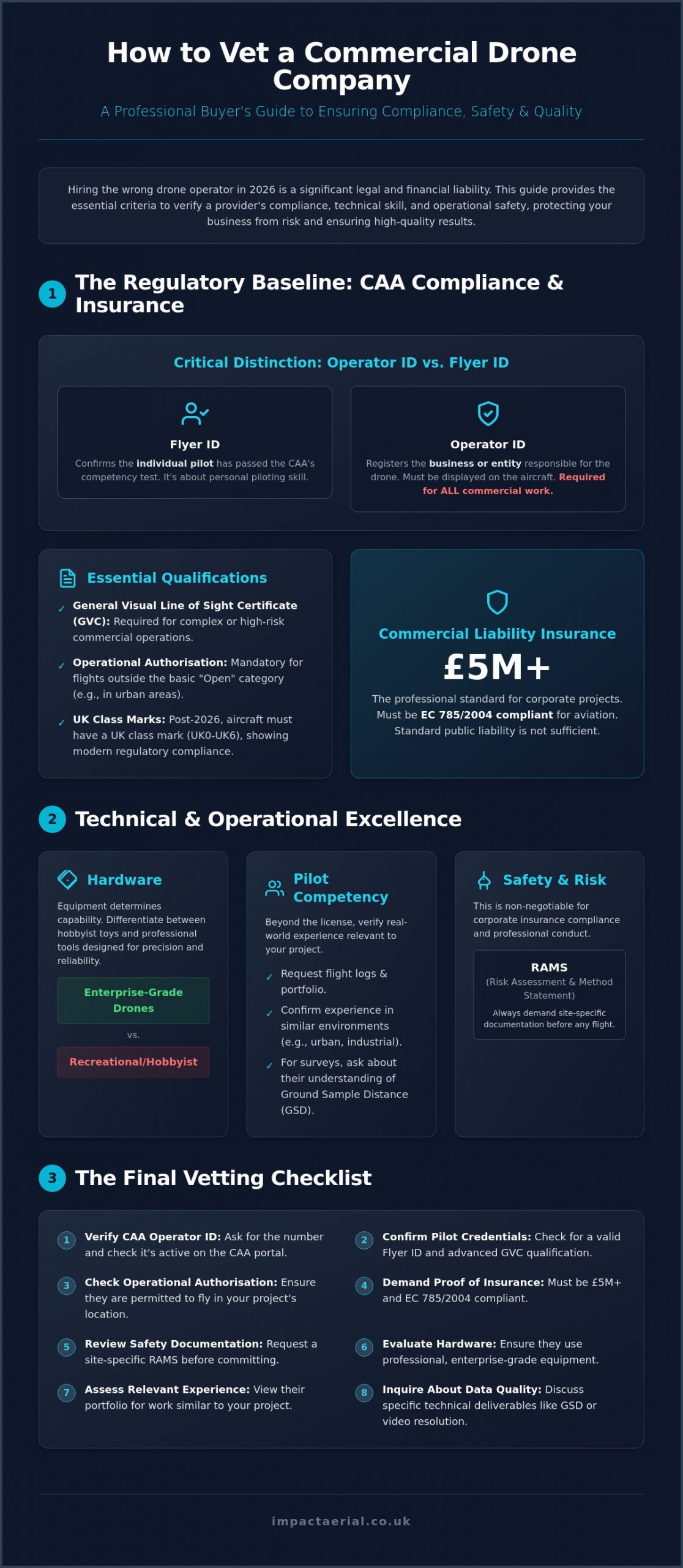
Compliance is the bedrock of professional aerial work. When you set out to learn how to vet a commercial drone company, your first step must be confirming that the provider exists legally within the Civil Aviation Authority (CAA) framework. There’s a critical distinction between an Operator ID and a Flyer ID. The Operator ID is the registration for the business entity responsible for the aircraft, while the Flyer ID confirms the individual pilot has passed the necessary competency tests. Understanding these global drone regulations ensures you aren’t accidentally hiring a hobbyist masquerading as a professional.
Vetting also requires checking for a valid Operational Authorisation on the CAA register. This document is essential for any flight that falls outside the basic “Open” category, such as work in congested urban areas or near industrial infrastructure. While older PfCO (Permission for Commercial Operations) qualifications have largely been replaced by the General Visual Line of Sight Certificate (GVC), you must verify that your pilot’s credentials are current. As of January 1, 2026, the UK has fully transitioned away from legacy drone categories; all new aircraft must carry a UK class mark from UK0 to UK6. Hiring an operator who doesn’t understand these transitions exposes your business to significant legal risk.
To better understand the level of professionalism required in this industry, watch this helpful video:
Validating the CAA Operator ID
A legitimate company will provide their Operator ID upon request. You can verify this number directly through the CAA’s official portal to ensure it remains active and linked to the correct business entity. By law, this Operator ID must be physically displayed on the aircraft in a clear, readable format. If a pilot claims they don’t need an ID because their drone weighs less than 250g, treat this as a major red flag. In a commercial context, any drone equipped with a sensor capable of capturing personal data requires a valid Operator ID, regardless of its weight.
Commercial Liability Insurance: The £5m Standard
Standard public liability insurance is rarely sufficient for the unique risks of aerial work. Professional operators must carry insurance that is specifically compliant with EC 785/2004, which is the legal standard for aviation insurance in the UK. Impact Aerial maintains a £5m commercial liability baseline to provide maximum peace of mind for our clients. Always verify that a provider’s policy covers the specific environment of your project, whether that involves a high-risk construction site or a city centre property survey. This level of coverage is a primary indicator of how to vet a commercial drone company for corporate-level reliability.
Technical Competency: Evaluating Pilot Skills and Hardware
Compliance ensures an operator is legal, but technical competency ensures they are capable. A pilot’s ability to capture high-accuracy survey data or cinematic 4K footage depends on a combination of advanced flight qualifications and specialized hardware. When you look at how to vet a commercial drone company, you must look beyond the basic flyer ID. True technical proficiency is demonstrated through sector-specific experience and the use of enterprise-grade equipment designed for precision rather than recreation.
Industry experts suggest that evaluating pilot skills requires a deep dive into flight logs and previous mission profiles. A pilot who primarily shoots rural landscapes may lack the spatial awareness required for complex structural inspections in dense urban environments like Birmingham. You should request proof of flight hours in similar settings to ensure the team can safely manage the unique risks of your specific site.
The GVC Certification Advantage
The General Visual Line of Sight Certificate (GVC) is the professional standard for drone operations in the UK. This qualification is more rigorous than basic online tests; it requires a formal practical flight assessment and a detailed operations manual. Holding a GVC allows a pilot to operate in the “Specific” category, which provides the legal flexibility to fly closer to people and property than hobbyist rules allow. For a detailed breakdown of these requirements, consult our UK Drone License guide.
Commercial-Grade Hardware Requirements
Professional results require professional tools. There is a vast difference between consumer drones and the DJI Enterprise hardware used by specialists. Impact Aerial utilizes advanced platforms like the DJI Matrice 350 RTK for technical surveys and the DJI Inspire 3 for high-end cinematic work. These systems offer features that consumer models lack:
- Redundancy: Dual-battery systems and multiple inertial measurement units (IMUs) ensure the drone stays airborne even if a component fails.
- Sensor Quality: 4K HDR cameras provide the dynamic range needed for professional post-production, while thermal sensors are essential for PV solar farm surveys.
- Safety Systems: 360-degree obstacle avoidance and built-in ADS-B receivers allow pilots to detect and avoid manned aircraft in real-time.
Redundancy isn’t optional for corporate projects. If you need reliable data for construction site monitoring, ensure your provider isn’t relying on consumer-grade “prosumer” drones that lack these critical safety and precision features.
Industry-Specific Expertise: Surveys vs. Creative Filming
A common mistake during procurement is assuming a drone is simply a flying camera. While the underlying technology is similar, the skillset required for a technical roof inspection is fundamentally different from that of a high-end marketing film. When you look at how to vet a commercial drone company, you must evaluate their specific experience in your required sector. A pilot who excels at sweeping cinematic shots may not understand the rigorous overlap and metadata requirements needed for accurate photogrammetry or topographical mapping.
For technical applications, vetting for data accuracy is paramount. You should ask potential providers about their Ground Sample Distance (GSD) capabilities. GSD represents the distance between the centres of two consecutive pixels measured on the ground; the lower the GSD, the higher the spatial resolution of the data. Professional standards, such as the FAA requirements for commercial drone pilots in the United States, mirror the UK’s own rigorous CAA certification process, emphasizing that commercial flight is a global professional standard requiring specific technical knowledge. High-accuracy survey data relies on this technical understanding of sensor resolution and flight altitude.
Vetting for Commercial Property Surveys
When reviewing a drone survey portfolio, look for consistency in image clarity and comprehensive coverage. A professional survey should include detailed metadata and sufficient image overlap to create high-resolution orthomosaics or 3D models. If you require specialized work, such as PV solar farm thermal surveys, ensure the company holds specific thermography certifications. They should also demonstrate how they integrate aerial data with other technologies, such as 3D virtual tours, to provide a complete view of the asset.
Vetting for Aerial Filming and Marketing
Creative vetting requires a different approach. Evaluate the company’s showreel not just for “cool shots,” but for smooth gimbal movement, professional colour science, and cinematic composition. Stability is key; any micro-jitters in the footage indicate poor hardware or lack of pilot skill. You should also consult our aerial filming drone guide to understand the cinematic standards expected in 2026. Ask whether the company provides end-to-end service, including post-production editing and colour grading, or if they only deliver raw files.
The vetting process shouldn’t end when the drone lands. You need to know how the data will be processed and delivered. A professional firm provides a complete solution, from initial risk assessment and flight planning to the delivery of actionable data or a polished final film. Ensure your chosen partner has the internal infrastructure to handle large 4K or 8K data sets and the technical expertise to translate that data into the specific formats your business requires.
Operational Safety and Risk Management (RAMS)
Safety is not just about avoiding accidents; it’s about systematic risk mitigation that protects your business from legal exposure. When considering how to vet a commercial drone company, you must evaluate their operational workflow before the drone even leaves its case. A professional operator treats every flight as a high-stakes aviation mission, requiring meticulous planning and clear communication protocols. This stage of the vetting process reveals the difference between a casual flyer and a technical specialist who understands the gravity of corporate liability.
Pre-flight planning starts days before the site visit. An expert team will assess the local airspace for permanent or temporary restrictions, identify ground hazards like overhead power lines, and monitor weather trends that could impact flight stability. On the day of the operation, the pilot in command must manage the site environment effectively. This includes establishing a “sterile area” for takeoff and landing and ensuring all site staff are briefed on the flight plan. They must also have a clear strategy for managing onlookers or members of the public who may enter the flight zone unexpectedly.
Emergency procedures are a vital component of professional vetting. You should ask your provider about their “Plan B” for various scenarios. What happens if there is a sudden equipment failure or an unauthorized aircraft enters the airspace? A compliant company has documented procedures for these events, ensuring the pilot can react instantly to maintain safety. This level of preparation is what guarantees a risk-free hiring process and ensures your corporate insurance remains valid throughout the project.
What a Professional RAMS Document Looks Like
A site-specific Risk Assessment and Method Statement (RAMS) is the most important document you will receive during the procurement phase. Unlike generic templates that some low-cost operators use, a professional RAMS is tailored specifically to your project location. It should include a detailed site map, specific identified hazards, clear mitigation steps, and emergency contact details for local authorities. You must review and sign off on the RAMS before any work begins to ensure all parties are aligned on the safety protocols and operational boundaries.
Airspace Management and Permissions
Managing the sky is as complex as managing the ground. Professional operators have the expertise to secure a Notice to Airmen (NOTAM) if the mission requires it, alerting other pilots in the vicinity to their presence. If your project is located near an airport or within a Restricted Area, the company must demonstrate their ability to coordinate directly with Air Traffic Control (ATC). They may also utilize trained ground observers to maintain a 360-degree view of the airspace, providing an extra layer of protection against mid-air incursions.
This level of meticulous planning ensures that your project remains compliant, safe, and efficient. If you require a partner that prioritizes safety and regulatory adherence above all else, contact Impact Aerial for a professional consultation on your next aerial project.
The Final Vetting Checklist: Impact Aerial’s Professional Standard
Vetting a drone provider shouldn’t be a guessing game that leaves your business exposed to legal or financial risk. By this stage, you understand that regulatory compliance is merely the entry requirement and that true value lies in technical precision and operational safety. When you finalize your decision on how to vet a commercial drone company, you need a structured framework to ensure no detail is overlooked. A transparent quote should always be comprehensive, accounting for insurance, complex airspace planning, and the final post-production phase to avoid hidden costs later in the project.
Impact Aerial provides this framework through our own meticulous operational standards. We believe that professional buyers deserve absolute clarity before a single propeller turns. Testing a company’s expertise through an initial consultation is the most effective way to gauge their problem-solving abilities and technical depth. A provider that cannot explain their specific ATC coordination strategy or the Ground Sample Distance of their sensors is unlikely to deliver the high-accuracy results your corporate standards demand.
The 10-Point Commercial Drone Vetting Checklist
Use this scannable list during your procurement process to guarantee your chosen partner meets the 2026 industry standards for safety and quality:
- Valid CAA Operator ID: Is the business registered and is the ID displayed on the aircraft?
- GVC Certified Pilots: Do the pilots hold the General Visual Line of Sight Certificate for complex work?
- £5m+ Insurance: Does the policy meet EC 785/2004 standards with adequate liability limits?
- Site-Specific RAMS: Have you received a Risk Assessment and Method Statement tailored to your location?
- Industry-Specific Portfolio: Can they show previous success in your specific sector, such as construction or thermal surveys?
- Enterprise-Grade Hardware: Are they using stabilized, redundant systems like DJI Enterprise models with 2026-compliant UK class marks?
- Clear Data Delivery Timeline: Is there a documented schedule for when you will receive your files?
- ATC/Airspace Planning: Is the coordination with Air Traffic Control and local authorities included in the service?
- Post-Production Capabilities: Does the company offer in-house editing, colour grading, or data analysis?
- Professional Body Memberships: Are they affiliated with recognized industry registers or trade associations?
Choosing Impact Aerial for Your Next Project
Our Birmingham-based team of experts handles the entire vetting process for you, ensuring every flight is conducted with surgical precision. We manage the complex administrative burden of airspace permissions and safety documentation, allowing you to focus on your core business objectives. Whether you require high-accuracy survey data or cinematic 4K HDR marketing visuals, our commitment to safety and quality is absolute. Contact us today for a tailored drone services consultation and discover why we are the preferred partner for UK-wide commercial projects.
Elevate Your Operational Standards for 2026
Mastering how to vet a commercial drone company is the difference between a successful project and a significant legal liability. You now have the framework to distinguish between hobbyist operators and technical specialists who prioritize safety, precision, and regulatory adherence. By insisting on CAA GVC Certified Pilots and verifying £5m Commercial Liability Insurance, you protect your corporate interests and ensure the highest quality results. Technical excellence isn’t just about the pilot’s skill; it’s about the reliability of DJI Enterprise Hardware and the meticulous execution of site-specific risk assessments.
Don’t leave your next project to chance. A risk-free hiring process starts with choosing a partner that treats every flight as a critical aviation mission. Whether you require high-accuracy survey data or cinematic marketing footage, we’re here to provide the expert-level compliance your business demands. Take the final step in your procurement process and Request a Professional Drone Service Quote from Impact Aerial to secure your next project with industry-leading standards. We look forward to helping you achieve your goals with technical excellence and absolute reliability.
Frequently Asked Questions
Do I need a drone license to hire a commercial drone company?
You don’t need a personal license to hire a provider. However, the company you hire must hold a valid CAA Operator ID and the individual pilot must possess a Flyer ID. Part of learning how to vet a commercial drone company is ensuring they have the correct Operational Authorisation for the specific mission. The legal responsibility for flight safety and compliance rests entirely with the drone operator, not the client.
What insurance should a professional drone company have?
A professional provider must hold aviation-specific liability insurance that is compliant with EC 785/2004. Standard business public liability policies often exclude aviation activities, leaving you exposed to significant risk. Most corporate clients require a minimum of £1 million in coverage, though higher-risk sites like construction or industrial plants often demand £5 million or more. Always request a Certificate of Insurance that names your company as an additional insured for the project.
How much does it cost to hire a commercial drone pilot in the UK?
Pricing for professional drone services is typically based on the complexity of the operation, the specialized hardware required, and the volume of post-production data processing. A cinematic marketing film has different resource requirements than a technical PV solar farm thermal survey. When you evaluate how to vet a commercial drone company, look for transparent quotes that include all pre-flight planning, insurance, and data delivery fees rather than just a basic hourly rate.
What is a CAA GVC certification and why does it matter?
The GVC, or General Visual Line of Sight Certificate, is the professional standard for drone pilots operating in the UK’s “Specific” category. It replaced the older PfCO and requires a formal theory exam and a practical flight assessment. This certification is vital because it grants the pilot the legal authority to fly closer to people and property in urban environments. It demonstrates that the pilot has reached a verified level of competency and safety management.
Can drones fly in rain or high winds for commercial surveys?
Professional enterprise drones like the DJI Matrice 350 RTK have high IP ratings for moisture resistance and can handle wind speeds up to 12 metres per second. However, heavy rain or extreme gusts usually require the flight to be rescheduled to protect data quality and operational safety. High-accuracy surveys require stable conditions to ensure the sensors capture clear, usable imagery without motion blur or sensor interference that could compromise the final data set.
What happens if a drone crashes during a shoot on my site?
If an incident occurs, the pilot follows the emergency protocols outlined in the site-specific RAMS document. A professional company’s EC 785/2004 compliant insurance will cover third-party property damage or injury. The operator is also required to report certain incidents to the CAA and the Air Accidents Investigation Branch. This structured response is why vetting for robust insurance and safety procedures is non-negotiable for corporate risk management and protecting your business reputation.
How long does it take to get the data back from a drone survey?
Delivery timelines depend on the level of post-production required. Raw 4K footage or basic inspection photos are often available within 24 hours of the flight. More complex outputs, such as processed 3D models or topographical surveys, typically require 48 to 72 hours for data stitching and quality checks. A professional firm will provide a clear delivery schedule as part of their initial quote so you can plan your project milestones with absolute confidence.
Do I need to notify the police if I hire a drone company?
You generally don’t need to notify the police for standard commercial flights on private property. The drone operator is responsible for all necessary permissions, including coordinating with Air Traffic Control if the site is within a Flight Restriction Zone. In some sensitive urban areas, the pilot may inform the local police as a courtesy to prevent public concern, but this is managed entirely as part of their standard pre-flight planning and risk mitigation process.