Construction Site Monitoring with Drones: The 2026 Professional Guide

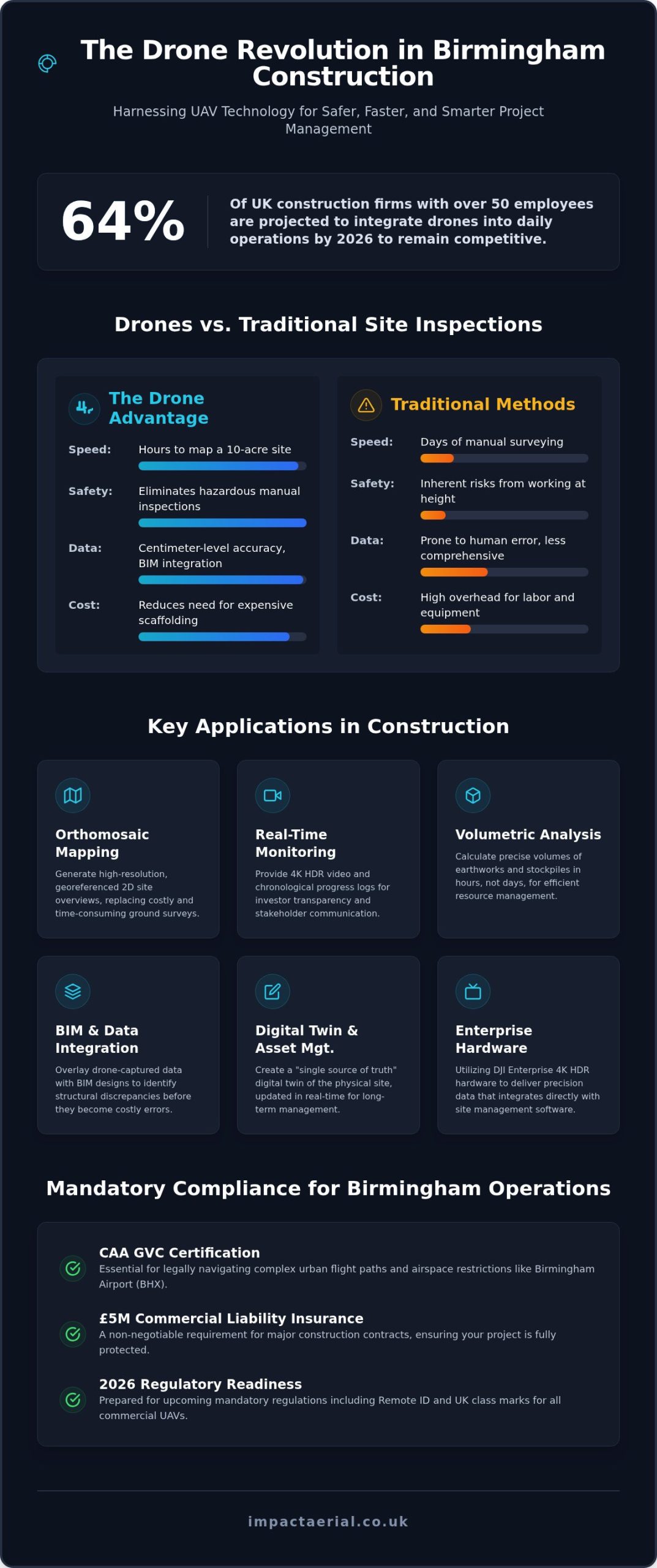
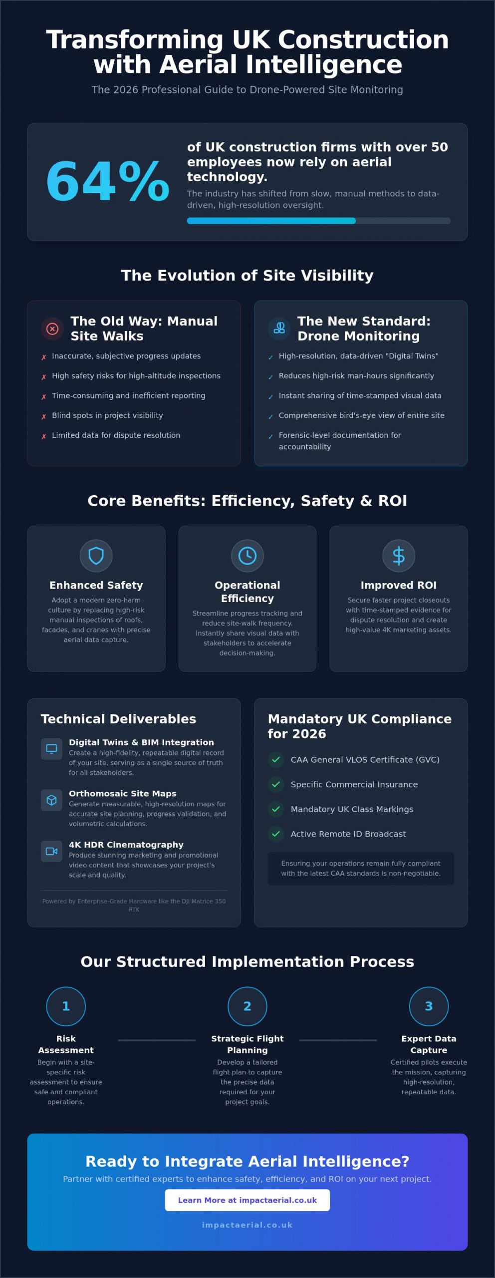
64% of UK construction firms with over 50 employees now rely on aerial technology to oversee their projects. It’s a massive shift from just a few years ago, driven by the need to replace slow, manual reporting with something more reliable. You’ve likely felt the frustration of inaccurate progress updates or the inherent risks of sending staff into high-altitude zones for basic inspections. Professional construction site monitoring with drones eliminates these bottlenecks by providing a high-resolution, bird’s-eye view that manual site walks simply can’t match.

In this 2026 professional guide, you’ll discover how high-tier drone data transforms site safety, streamlines progress tracking, and secures a better ROI for your UK projects. We’ll walk you through the latest CAA compliance standards, including mandatory UK class markings and Remote ID requirements that took full effect this year. You’ll also learn how integrating data from enterprise-grade hardware like the DJI Matrice 350 RTK leads to faster project closeouts and provides the time-stamped documentation you need for dispute resolution. From reducing site-walk frequency to building accurate digital twins, we’re covering the technical standards that define modern site management.

Key Takeaways

  • Learn how the transition from manual site walks to repeatable digital twin creation provides a more accurate, high-resolution record of project development.
  • Understand how professional construction site monitoring with drones reduces high-risk man-hours by replacing manual inspections of cranes and roofs with precise aerial data.
  • Explore the technical deliverables that drive project value, ranging from high-resolution 4K HDR marketing cinematography to measurable orthomosaic site maps.
  • Identify the critical legal requirements for 2026, including the necessity of CAA GVC certification and specific insurance to ensure your operations remain fully compliant.
  • Discover the structured approach to implementing aerial monitoring, beginning with site-specific risk assessments and strategic flight planning by certified experts.

What is Construction Site Monitoring with Drones?

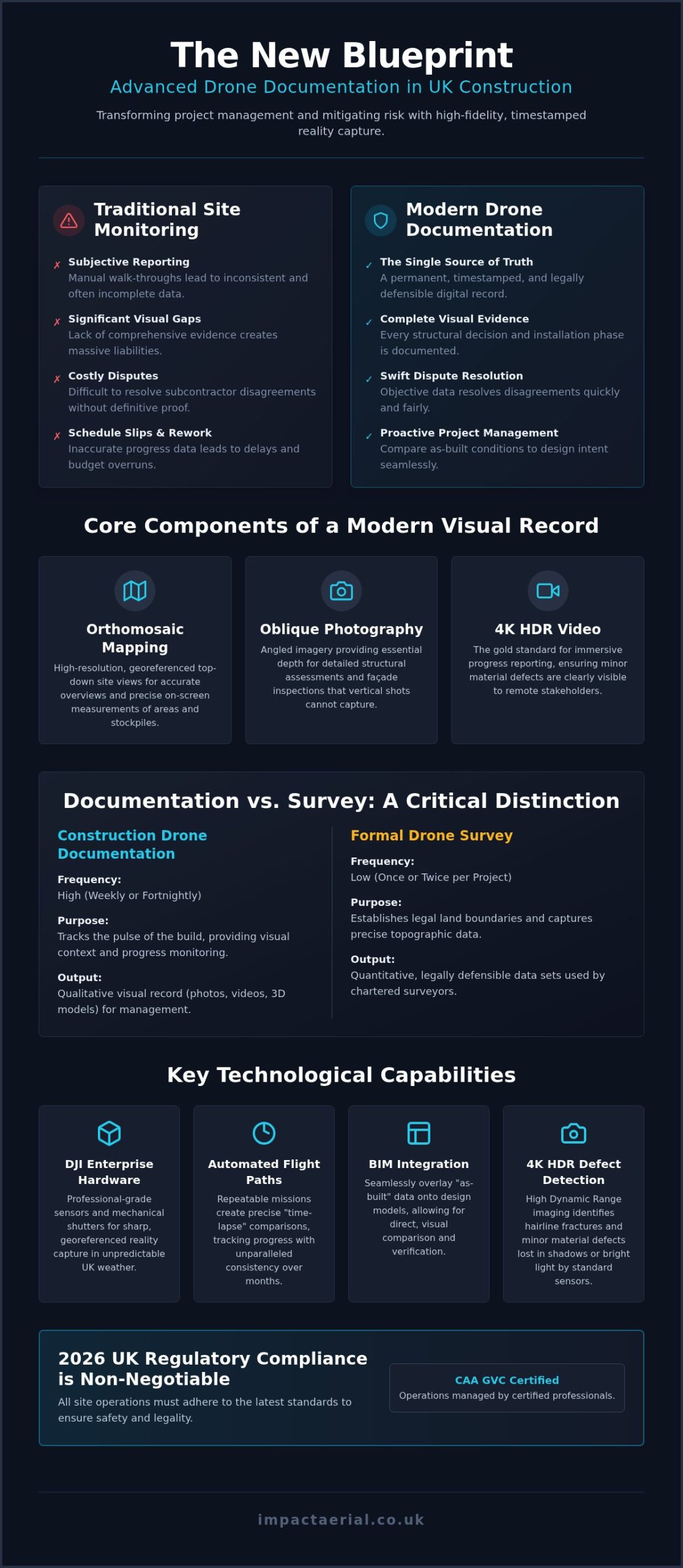
Modern project management has moved beyond the limitations of the handheld camera. Construction site monitoring with drones is the professional practice of using sophisticated aerial platforms to capture repeatable, high-resolution data across the entire lifecycle of a build. By 2026, the UK industry has transitioned away from subjective manual site walks toward the creation of high-fidelity digital twins. These digital models provide a single source of truth for every stakeholder involved. To understand the technology behind these platforms, it’s helpful to look at the broader definition of What is an Unmanned Aerial Vehicle (UAV)? as these aircraft are the engines of this data revolution.

To better understand this concept, watch this helpful video:

The Evolution of Site Visibility

Traditional ground-level photography often fails to capture the full scale of a development, leaving blind spots in progress reports. High-resolution 4K HDR aerial imagery provides a comprehensive perspective that replaces qualitative “looks good” updates with quantitative data points. Every flight generates time-stamped documentation, allowing project managers to verify timelines with absolute precision. This level of visibility isn’t a luxury; it’s a baseline requirement for modern UK contract management. We’ve moved from simple snapshots to data-centric processes where every pixel serves as a record of progress.

Types of Monitoring Workflows

Effective monitoring follows a structured cadence tailored to the project’s complexity. Periodic updates, typically conducted on a weekly or monthly basis, keep off-site stakeholders informed without requiring frequent, time-consuming site visits. Using construction site monitoring with drones for these updates ensures that every stakeholder has access to the same high-resolution visual record. On-demand inspections address specific structural or safety concerns as they arise, such as verifying crane clearances or inspecting high-altitude facade elements. Many firms also integrate strategic drone property surveys during the pre-construction phase to establish accurate site baselines.

From initial site clearance to final punch-list verification, the use of drones ensures that every phase of construction is documented with forensic detail. This meticulous approach reduces the frequency of site walks and provides the high-tier evidence needed for dispute resolution. It’s about providing psychological comfort to clients while delivering tangible, data-driven benefits to the bottom line.

Key Benefits: Efficiency, Safety, and Project ROI

Professional construction site monitoring with drones delivers measurable improvements to operational safety and financial performance. By replacing manual roof and crane inspections, firms significantly reduce high-risk man-hours. This shift doesn’t just save time; it protects lives by keeping personnel on the ground while high-resolution sensors capture every detail from above. Stakeholder communication also accelerates through cloud-based platforms, allowing site managers to share time-stamped visual data with off-site teams instantly. This transparency helps identify logistical bottlenecks, such as equipment positioning or material delivery delays, before they impact the project’s critical path.

Health and Safety Improvements

Adopting aerial technology is a cornerstone of a modern zero-harm culture. Traditional visual checks often require expensive scaffolding or risky ladder use, both of which are eliminated through precise, repeatable flight paths. Drones identify potential hazards like unsecured materials or perimeter breaches that are easily missed from ground level. This proactive approach is supported by university research on drone safety, which highlights how UAVs perform dangerous tasks more efficiently than human inspectors. Integrating drones and surveying into your safety protocols ensures that high-altitude inspections are conducted without exposing staff to unnecessary danger.

Calculating the Return on Investment

The financial benefits of construction site monitoring with drones are concrete and immediate. UK construction firms report time savings of up to 20-30% on surveying and progress tracking tasks. One housing development project recently saved £20,000 by opting for drone surveying over traditional methods. These savings stem from more accurate stockpile measurements for material management and the reduction of expensive rework through early error detection. High-resolution documentation also provides an indisputable record for dispute resolution, protecting your firm from unfounded claims. Drone data prevents costly project delays by identifying deviations from the site plan in real-time. For developers looking to secure these efficiencies, partnering with an expert for professional construction monitoring is the most direct route to maximizing site ROI.

Beyond simple progress tracking, drones enhance site security and asset tracking across large-scale developments. Automated flight paths can monitor the movement of high-value machinery and materials, ensuring that site assets are exactly where they should be. This level of oversight provides reassurance to both investors and project managers that the site is being managed with meticulous precision.

Construction Site Monitoring with Drones: The 2026 Professional Guide

Technical Deliverables: From 4K Video to BIM Integration

Professional construction site monitoring with drones produces a suite of high-tier technical deliverables that extend far beyond simple photography. For project managers, the primary value lies in the precision and repeatability of the data captured. High-resolution 4K HDR cinematography provides crystal-clear visual records for both internal progress tracking and external stakeholder updates. While these visuals are vital for documentation, they also serve a secondary purpose in high-end marketing, showcasing the scale and quality of the build to potential investors or clients in a way that ground-level shots cannot match.

Orthomosaic mapping is another critical output, involving the stitching together of hundreds of aerial images to create a single, measurable, top-down map of the entire site. These maps are georeferenced, allowing teams to take accurate measurements of distances and areas directly from the digital file. For projects utilizing Building Information Modelling (BIM), 3D point clouds and mesh models allow for a direct comparison between the “as-built” progress and the original architectural designs. This integration ensures that any deviations are caught early, maintaining the integrity of the project design and preventing expensive remedial work later in the schedule.

Progress Reporting Formats

Effective communication depends on how data is presented to decision-makers. We provide side-by-side “Then vs. Now” visual comparisons that clearly illustrate development milestones during board meetings or client briefings. Annotated imagery allows site managers to highlight specific issues, such as structural concerns or material misplacements, and share them directly with contractors for immediate action. Many clients also leverage our construction site monitoring with drones alongside specialized aerial filming drone techniques. This combination delivers cinematic marketing assets that capture the project’s evolution with an aspirational quality that enhances the brand’s professional image.

Advanced Data Collection

Beyond visual updates, drones equipped with thermal sensors identify heat loss or moisture ingress in new builds before the final handover. This technical oversight is essential for meeting modern UK building standards and ensuring long-term structural health. For earthworks and excavation, volumetric analysis provides precise data on stockpile volumes and soil movement, which is vital for accurate material management.

The accuracy of these deliverables relies heavily on the use of DJI Enterprise grade hardware. Utilizing platforms like the Matrice 350 RTK ensures that topographic data is captured with centimetre-level precision, which is necessary for drainage assessments and initial site planning. By moving from qualitative assessments to quantitative data points, firms gain a level of site control that provides both psychological comfort and tangible financial benefits.

UK Compliance: Why CAA GVC and Insurance Matter

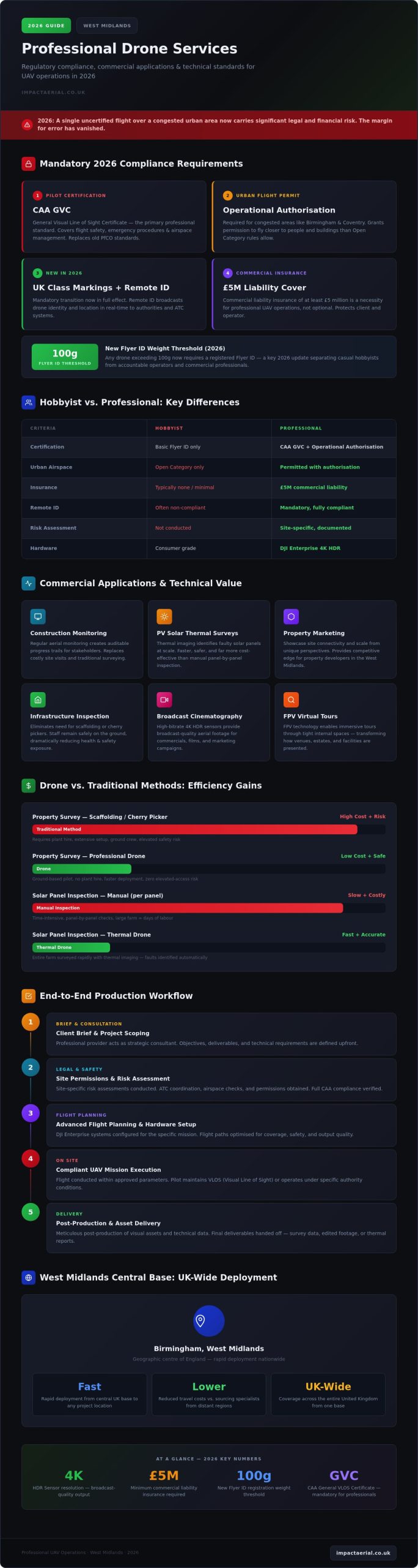
Legal compliance is the foundation of any professional aerial operation. For construction site monitoring with drones, using an uncertified pilot isn’t just a safety risk; it’s a significant legal liability for the site manager. As of January 1, 2026, the transitional arrangements for UK drone operations have officially ended, making it mandatory for operators to adhere to a stricter framework involving UK class markings and Remote ID. Operating without the correct CAA permissions or valid commercial insurance can lead to heavy fines and the immediate halt of site activities. Ensuring your drone partner is fully vetted provides the psychological comfort that your project remains on the right side of the law.

Navigating CAA Regulations

Understanding the distinction between different certifications is vital for project planning. While the A2 Certificate of Competence (A2 CofC) allows for basic operations, the General Visual Line of Sight Certificate (GVC) is the industry standard for complex construction environments. The GVC is required for pilots seeking Operational Authorisation from the CAA, which is essential when flying enterprise-grade hardware in congested areas. A professional pilot handles all flight permissions, including navigating restricted UK airspace and managing the £524 CAA application fee for specific authorisations. For a more detailed breakdown of these requirements, consult our comprehensive drone license guide.

Complex urban projects, such as those in Birmingham city centre, often require an Operational Safety Case (OSC). This advanced permission allows pilots to operate closer to people and structures than standard rules permit, which is often necessary for high-resolution facade inspections or tight site perimeters. Managing these permissions requires a meticulous approach to risk assessment that only a qualified specialist can provide.

Insurance and Liability

Standard recreational drone insurance is entirely invalid for construction site monitoring with drones. Commercial operations require specialist policies that comply with EC 785/2004 regulations. We recommend a minimum of £5m public liability insurance for sub-20kg drones, though larger developments often require up to £10m to meet corporate risk requirements. This coverage protects the site manager from vicarious liability in the event of an incident, ensuring that the financial burden doesn’t fall on the construction firm. Professional indemnity insurance is essential to cover the accuracy and reliability of the digital data and topographic surveys provided to the project team. To ensure your next project is managed by a compliant and fully insured team, book a professional site consultation with our GVC-certified pilots today.

By prioritizing vetted contractors who understand the 2026 regulatory landscape, you eliminate the guesswork from aerial data collection. It’s about more than just capturing images; it’s about maintaining a compliant, safe, and professional site environment that stands up to regulatory scrutiny.

Implementing Drone Monitoring with Impact Aerial

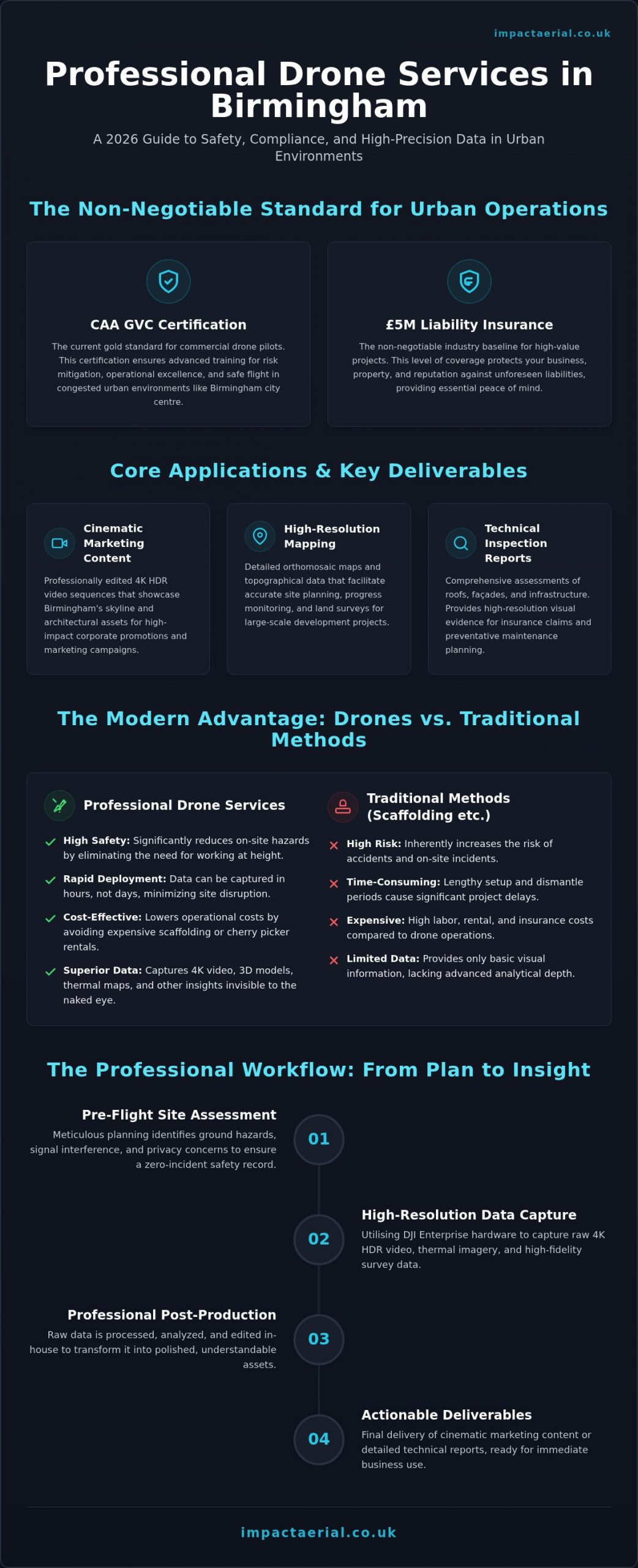
Integrating professional construction site monitoring with drones into your workflow is a structured process designed to minimize disruption while maximizing data quality. We follow a methodical four-step implementation plan to ensure every flight delivers tangible value to your project team. This systematic approach allows site managers to focus on the build while we handle the complexities of aerial data collection and regulatory compliance.

  • Step 1: Initial Consultation. We begin by defining your monitoring frequency and specific data needs. Whether you require weekly progress updates for stakeholders or high-fidelity 3D models for BIM comparison, we tailor the mission to your project’s critical path.
  • Step 2: Risk Assessment and Flight Planning. Our GVC-certified pilots conduct a comprehensive site risk assessment. We manage all necessary flight permissions and coordinate with local authorities to ensure safe operations in complex UK airspace.
  • Step 3: Precision Data Capture. Using commercial-grade DJI Enterprise drones, we capture high-resolution imagery and topographic data. Our hardware ensures centimetre-level accuracy, which is essential for measurable site maps and volumetric analysis.
  • Step 4: Post-Production and Delivery. Raw data is processed into actionable site insights. We deliver high-tier visual reports and data files that are ready for immediate use in board meetings or project management software.

Why Outsource Your Site Monitoring?

While some firms consider building an internal team, 77% of UK construction companies prefer to outsource their aerial operations to specialists. This decision avoids the significant capital expenditure required to purchase and maintain DJI Matrice or Mavic Enterprise fleets. Outsourcing also removes the ongoing burden of pilot training and the administrative weight of managing CAA Operational Authorisations. By partnering with a specialist, you ensure that your construction site monitoring with drones is performed to the highest technical standards. You gain access to professional post-production services that turn raw footage into sophisticated, client-ready reports without the internal overhead or equipment depreciation risks.

Our Professional Standards

Based in Birmingham, we serve the West Midlands and projects across the UK with a meticulous focus on safety and precision. Our operations are built on a foundation of strict adherence to safety protocols and the latest 2026 regulatory standards. We understand that site managers need reliable data for dispute resolution and accurate progress tracking. If you’re ready to enhance your project oversight with expert aerial data, contact Impact Aerial for a tailored construction monitoring quote and discover how our professional oversight can protect your site’s ROI.

Securing the Future of Your Site Oversight

The transition toward data-centric project management is no longer a future prospect; it’s the current standard for competitive UK developers. By integrating professional construction site monitoring with drones, you replace subjective reporting with a high-resolution, time-stamped record of every build phase. This approach doesn’t just streamline stakeholder communication; it provides the forensic detail required for dispute resolution and high-altitude safety inspections that were previously impossible to conduct without significant risk.

Success in this specialized field requires more than just hardware. It demands meticulous adherence to the latest CAA regulations and a commitment to operational excellence. Our team provides the psychological comfort of knowing your project is in expert hands, utilizing a DJI Enterprise fleet capable of high-end 4K HDR output. With CAA GVC certified pilots and £5m commercial liability insurance as our baseline, we ensure your site remains compliant and secure while delivering actionable insights that drive project ROI. Request a Professional Construction Site Monitoring Quote to see how we can transform your site visibility. We look forward to helping you achieve faster project closeouts through unparalleled site oversight.

Frequently Asked Questions

Do I need a special permit for drone monitoring on my construction site?

Commercial construction site monitoring with drones requires Operational Authorisation from the Civil Aviation Authority (CAA). This isn’t a simple permit but a legal requirement based on a pilot’s General Visual Line of Sight Certificate (GVC). For complex urban sites, a specialist may also need an Operational Safety Case (OSC) to fly closer to people or buildings than standard regulations allow.

How much does construction site monitoring with drones cost in the UK?

Pricing for aerial monitoring is determined by the project’s complexity, the frequency of flights, and the specific technical deliverables required. A one-off site survey has a different cost structure than a year-long weekly progress tracking contract. We provide tailored quotes that reflect the specific hardware needs and data processing requirements of your development to ensure maximum value.

Can drones fly in rain or high winds on a construction site?

Modern enterprise drones like the DJI Matrice 350 RTK are designed with IP55 weather resistance and can operate in moderate rain. However, high winds exceeding 12 metres per second typically require a grounded flight for safety. Our pilots monitor local METAR data to ensure every mission is conducted within the safe operational limits of the aircraft and the sensors.

What is the difference between an orthomosaic map and a standard aerial photo?

A standard aerial photo is a single perspective snapshot that contains geometric distortion. An orthomosaic map is created by stitching hundreds of images together and correcting them for perspective and scale. This results in a georeferenced, top-down map where every pixel is accurate. It allows your team to take precise measurements of distances and areas directly from the digital file.

How often should a drone monitor a construction site for progress tracking?

Monitoring frequency depends on the pace of the build and your reporting requirements. Most UK projects opt for weekly or bi-weekly flights to maintain a consistent record for stakeholder updates. During high-activity phases, such as earthworks or structural steel erection, more frequent flights might be necessary to capture the rapid changes on the project’s critical path.

Is drone monitoring compliant with GDPR when flying near residential areas?

Professional drone operations are fully compliant with GDPR and UK data protection laws. We conduct Privacy Impact Assessments before flights and use post-production techniques to blur faces, house windows, and vehicle registration plates. This ensures that while we capture essential site data, the privacy of the surrounding community is meticulously protected throughout the monitoring process.

What insurance coverage should a professional drone pilot have for construction?

A professional pilot must hold commercial public liability insurance that is compliant with EC 785/2004. For most UK construction sites, a minimum of £5m coverage is expected, though larger infrastructure projects often require £10m. This insurance protects the site manager and the developer against third-party property damage or injury claims, providing essential financial security.

Can drone data be integrated directly into BIM software like Revit or AutoCAD?

Aerial data is easily integrated into Building Information Modelling (BIM) workflows. We provide georeferenced 3D point clouds and orthomosaics in industry-standard formats like .LAS, .OBJ, and .GeoTIFF. These files can be imported directly into Revit or AutoCAD. This allows for a precise side-by-side comparison between the as-built site and the original architectural designs to catch deviations early.

Choosing a Drone Videography Style: The Ultimate Guide for UK Businesses in 2026

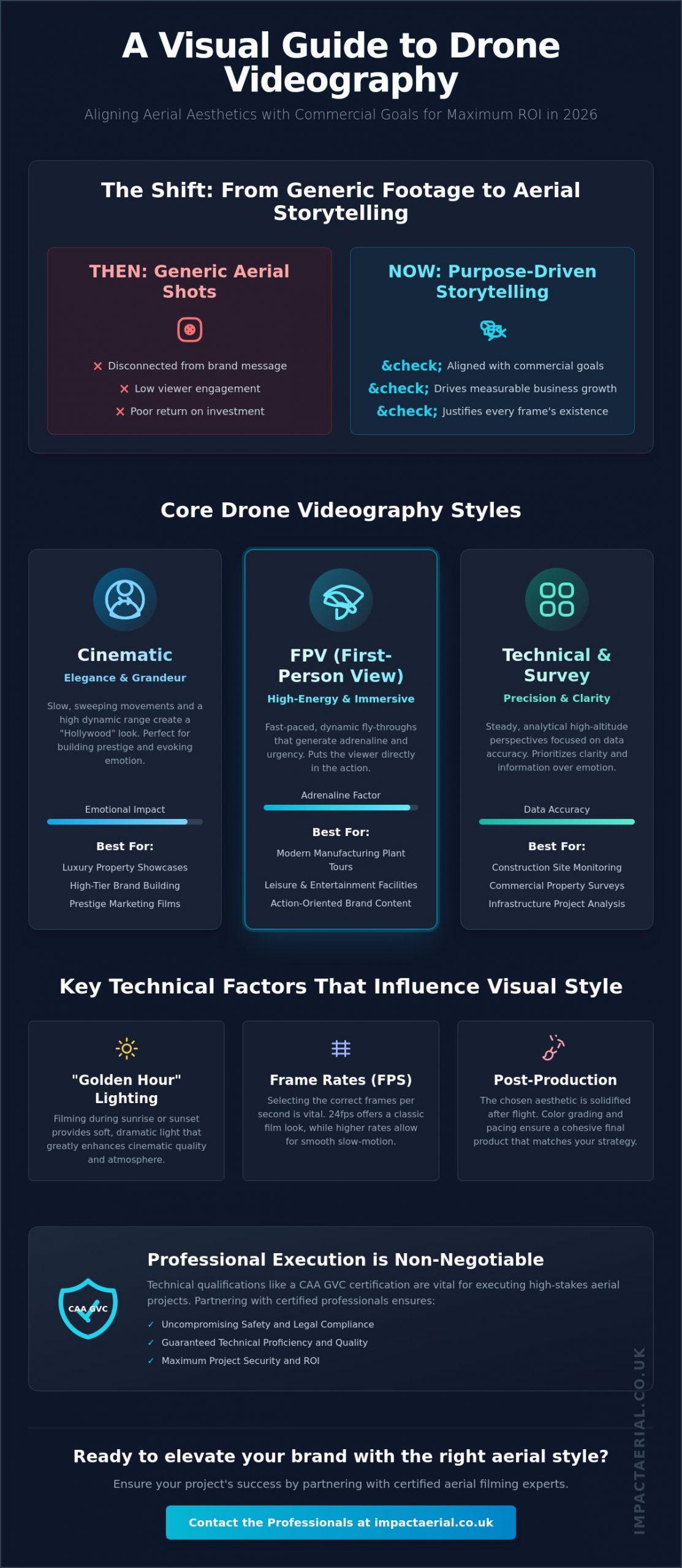
The most expensive 8K aerial footage on the market will fail to deliver a return on investment if the visual language doesn’t align with your sector’s specific goals. In 2026, simply putting a camera in the air is no longer a competitive advantage. Success now depends on choosing a drone videography style that speaks directly to your audience; whether that is the high-octane energy of an FPV fly-through for a leisure facility or the steady, technical precision required for construction site monitoring.

You likely recognize that generic, drifting shots often feel disconnected from your brand’s core message, yet the technical jargon of the industry can make briefing a pilot feel like a gamble. This guide bridges that gap. You’ll discover how to select the perfect aerial aesthetic to elevate your brand, ranging from cinematic sweeps to high-speed FPV immersive tours. We provide a structured breakdown of the latest 2026 UK flight standards and aesthetic categories, ensuring you have the confidence to secure high-quality, compliant results that drive tangible business growth.

Key Takeaways

  • Understand how the intersection of movement and narrative intent drives project ROI by aligning visual style with your specific commercial objectives.
  • Learn the critical differences between cinematic sweeps and immersive FPV tours to assist in choosing a drone videography style that suits your brand identity.
  • Identify the specific aesthetics used for construction site monitoring and commercial property surveys to maximize engagement and data accuracy in your sector.
  • Master the technical essentials of professional aerial filming, including the impact of “Golden Hour” lighting and selecting the correct frame rates for your desired look.
  • Discover why technical qualifications and CAA GVC certifications are vital for executing high-stakes aerial projects safely and to a professional standard.

Why Choosing the Right Drone Videography Style Defines Your Project’s ROI

A professional drone videography style is far more than a simple flight path; it is the deliberate intersection of camera movement, lighting conditions, and narrative intent. In the current 2026 market, stakeholders demand more than generic bird’s-eye views. Achieving a high return on investment requires a foundational understanding aerial videography and how specific visual languages influence viewer psychology. For instance, a slow, high-altitude orbit provides an analytical, “God-view” perspective that suggests stability and scale, whereas a low-level, high-speed tracking shot generates adrenaline and urgency.

Choosing a drone videography style that clashes with your brand identity can be a costly error. An aggressive, high-speed FPV fly-through might work for a modern manufacturing plant, but using that same kinetic energy for a Grade I listed heritage site often feels jarring and disrespectful to the subject matter. As drone technology has matured, the 2026 trend has shifted decisively away from “generic b-roll” toward purpose-built visuals. Every frame must justify its existence by supporting a specific commercial goal, whether that is proving construction progress or selling the prestige of a luxury development.

To better understand this concept, watch this helpful video:

The Shift from “Aerial Footage” to “Aerial Storytelling”

The “wow” factor of seeing the world from above has largely evaporated as drones have become ubiquitous. Today, professional aerial filming drone services focus on functional visual communication. We use specific flight maneuvers to solve business problems; such as using a “reveal” shot to highlight a property’s proximity to transport links. Post-production also plays a critical role here. The color grading and pacing applied after the flight solidify the chosen aesthetic, ensuring the final output feels like a cohesive part of your broader marketing or technical strategy rather than a disconnected clip.

Setting Objectives Before Selecting a Visual Look

Before choosing a drone videography style, you must define the primary objective of your project. Information-heavy tasks, like construction site monitoring, require a steady, high-resolution style that prioritizes clarity and data over emotional impact. Conversely, brand-led campaigns for luxury properties rely on “hero” shots that emphasize atmosphere and prestige. Your primary KPI might be technical accuracy, speed of delivery, or perhaps pure brand elevation. Visual ROI is the measurable impact of a specific aesthetic choice on conversion rates, stakeholder engagement, or project clarity. By aligning the flight style with these KPIs, you ensure the footage serves as a tool for growth rather than a mere digital asset.

Exploring the Core Drone Videography Styles: From Cinematic to FPV

Selecting the right visual language is the most critical decision in the pre-production phase. Each aesthetic serves a distinct commercial purpose, utilizing different flight dynamics and sensor settings to communicate your message. In 2026, the industry has moved beyond simple “fly-overs” to specialized disciplines. Whether you are documenting a multi-million pound infrastructure project or launching a luxury brand, choosing a drone videography style that aligns with your technical requirements is essential for a professional result.

The Cinematic Aesthetic: Elegance and Grandeur

The cinematic style remains the benchmark for high-tier brand building and prestige marketing. This “Hollywood” look is defined by slow, sweeping movements and a high dynamic range that preserves detail in both shadows and highlights. Professional pilots utilize specific maneuvers like the “Reveal,” where the camera starts on a detail before rising to show the landscape, and the “Orbit,” a perfectly circular path around a central subject. To achieve this, we prioritize 4K HDR or 8K resolution with 10-bit color depth, providing the necessary data for high-end post-production grading. This style is most effective for tourism, corporate brand films, and luxury property marketing where the goal is to evoke an emotional response through scale and beauty.

FPV Drone Filming: Immersive Innovation

The Narrative Style: Context and Scale

The narrative style focuses on establishing a “Sense of Place” by integrating aerial perspectives into a larger storytelling framework. It isn’t about the drone shot itself, but how that shot connects ground-level human experiences to their wider environment. This often involves combining low-altitude tracking shots with high-altitude wide views to show the relationship between a project and its surrounding infrastructure. Executing these complex, multi-layered flights legally and safely requires a valid drone license and a deep understanding of UK airspace restrictions. By bridging the gap between technical data and emotive visuals, the narrative style provides the context necessary for stakeholders to grasp the full scope of a project. If you’re unsure which aesthetic best serves your goals, consulting with a specialist in professional aerial filming can help clarify the most effective path forward for your specific sector.

For technical applications like construction site monitoring or commercial property surveys, the focus shifts toward architectural precision. These styles prioritize symmetry, structural lines, and top-down “nadir” views that provide accurate spatial data. By choosing a drone videography style that emphasizes these technical elements, businesses can track progress with millimeter precision while maintaining a professional visual standard that is suitable for investor reporting.

Choosing a Drone Videography Style: The Ultimate Guide for UK Businesses in 2026

Industry Match: Which Style Fits Your Specific Sector?

The effectiveness of an aerial campaign is measured by its ability to meet sector-specific KPIs. A visual approach that excels in the creative arts will likely fail in a heavy industrial context. When choosing a drone videography style, you must evaluate whether your primary goal is the acquisition of technical data, the emotional engagement of a buyer, or the documentation of project milestones. In 2026, UK businesses are increasingly moving away from multi-purpose footage in favor of “style-to-sector” alignment that ensures every flight minute contributes to the bottom line.

Construction: Progress vs. Promotion

In the construction and infrastructure sectors, drone footage serves two distinct masters: the site engineer and the marketing director. For technical oversight, a professional drone survey is the standard for capturing high-resolution orthomosaic data and site logistics. These flights utilize a top-down, “nadir” perspective, providing a flat, measurable map of the site that is essential for identifying bottlenecks. Conversely, for stakeholder reporting and promotion, a cinematic time-lapse style is preferred. This involves capturing the same flight path over several months to show the evolution of the build. By maintaining consistent GPS coordinates for each flight, we create a seamless visual record that demonstrates progress with authoritative clarity.

Real Estate: The Luxury Reveal

Commercial property and luxury residential listings require an aesthetic that emphasizes prestige and spatial flow. The “Dolly Zoom” and the “Orbit” have become the industry standards for high-end listings, as they provide a sense of three-dimensional depth that static photography lacks. To create a truly immersive experience, we often utilize FPV drones to execute a “one-take” sequence. This involves flying from the exterior grounds, through the front entrance, and into the primary living or office spaces without a single cut. This style doesn’t just show a property; it provides a virtual tour that establishes a “Sense of Place.” Highlighting local landmarks within the same frame as the property further increases perceived value by grounding the asset in its wider geographical context.

Renewable Energy and Marketing

The renewable energy sector, particularly solar farm management, relies on a technical “Grid” style. This involves automated flight paths that ensure 100% coverage for thermal imaging and visual inspections. These surveys are data-centric, focusing on identifying anomalies in PV panels with surgical precision. In contrast, the marketing and advertising sectors demand high-energy FPV and cinematic storytelling. These styles are designed to capture attention within the first three seconds of a social media scroll. Whether it’s a high-speed chase for a dynamic product launch or a sweeping 8K panoramic for a tourism board, choosing a drone videography style that matches the energy of your target demographic is the most reliable way to ensure a high return on investment.

Key Technical Factors That Influence Your Visual Style

Achieving a high-end visual result is impossible without mastering the technical variables that underpin every flight. When choosing a drone videography style, you aren’t just selecting a movement; you are selecting a specific configuration of light, frame rates, and hardware capabilities. These settings dictate whether the final output feels like a high-budget feature film or a sharp, clinical data set. In the professional sector, we use these technical levers to ensure the aesthetic aligns with your commercial objectives while maintaining the highest standards of precision.

Lighting remains the most influential factor in cinematic drone filming. The “Golden Hour,” occurring during the first hour of sunrise and the last hour of sunset, provides the soft, directional light and long shadows that define the cinematic aesthetic. For technical surveys or construction monitoring, we often prefer “Blue Hour” or high-noon lighting to minimize shadows and maximize the clarity of structural details. To control this light, we utilize Neutral Density (ND) filters. These act as “sunglasses” for the drone’s sensor, allowing us to maintain a slower shutter speed. This is essential for creating the natural motion blur that viewers associate with professional-grade production.

Frame rates also play a vital role in defining the look of your project. We typically use 24fps (frames per second) for a traditional “filmic” look, as it mimics the way the human eye perceives motion. Conversely, 60fps or higher is selected for high-speed action or FPV tours, allowing for smooth playback or the ability to slow down footage in post-production without losing detail. The final style is then solidified through professional post-production services, where color grading and sound design act as the final “brushstrokes” that align the footage with your brand’s visual identity.

Weather and Environmental Constraints in the UK

The unpredictable UK climate directly influences which styles are feasible on any given day. High winds and variable light conditions in regions like the West Midlands require robust hardware. We often deploy DJI Enterprise drones for these environments, as their superior stabilization systems ensure smooth footage even in gusty conditions. Planning for the “Birmingham Look” often involves working with specific urban textures and flat lighting, where technical expertise in exposure management is required to prevent footage from looking washed out or overly industrial.

Compliance as a Creative Constraint

Safety and regulation are the primary filters through which all creative decisions must pass. While an aggressive FPV fly-through might look impressive, CAA regulations regarding “flight over people” or congested areas may limit where these maneuvers can be performed. Our commitment to meticulous risk mitigation includes maintaining £5m in commercial liability insurance, ensuring that your chosen style never compromises safety protocols. Before choosing a drone videography style for a complex urban shoot, it’s vital to consult with a qualified operator who understands how to balance creative ambition with legal compliance.

For a detailed assessment of how these technical factors will impact your next project, contact Impact Aerial today for a professional consultation.

Partnering with Impact Aerial: Professional Execution of Any Drone Style

Choosing a drone videography style is only the first step in creating a high-impact visual asset. The successful execution of that vision requires a partner who understands the intricate balance between creative ambition and stringent safety standards. At Impact Aerial, we don’t just provide footage; we offer a technical consultancy that ensures your chosen aesthetic is delivered with surgical precision. By bridging the gap between technical surveying and creative videography, we provide UK businesses with the reassurance that their projects are in expert hands.

Our operational excellence is built on a foundation of high-end hardware and elite certification. We utilize commercial-grade DJI Enterprise drones, capable of capturing 4K HDR data with the stability required for professional post-production. These platforms are essential for maintaining the visual integrity of cinematic sweeps or technical site monitoring in variable UK weather. Every flight is conducted by CAA GVC certified pilots, ensuring that even the most complex urban maneuvers are executed within the full framework of national aviation law. This meticulousness provides our clients with psychological comfort and tangible business benefits.

The Impact Aerial Project Management Process

We approach every project with a structured, methodical workflow designed to eliminate risk and maximize visual ROI. Our process is divided into three distinct phases:

  • Consultation: We begin by defining your visual goals and industry requirements. Whether you are choosing a drone videography style for a promotional campaign or a technical survey, we align our flight plan with your specific KPIs.
  • Planning: Our team handles all necessary risk assessments and flight permissions. We tailor these permissions to your chosen style, ensuring that even high-stakes FPV tours or architectural reveals are fully compliant with local bylaws and CAA regulations.
  • Delivery: We provide high-end output that is ready for immediate use across social media, web, or broadcast platforms. Our post-production services ensure that the final edit reflects the precise aesthetic established during the consultation phase.

Request Your Custom Aerial Style Consultation

In the current market, a drone services provider should be a strategic partner rather than just a pilot. We have a proven track record of successful style implementations in Birmingham and across the UK, ranging from large-scale construction monitoring to immersive virtual tours for commercial property. We understand the specialized nature of the UK drone industry and remain at the forefront of regulatory changes to ensure your brand remains both innovative and compliant.

If you are ready to elevate your project with a specialized visual language, we invite you to discuss your project with Impact Aerial today. Our team is available to provide a detailed assessment of your requirements and help you navigate the complexities of choosing a drone videography style that delivers a measurable return on investment.

Elevate Your Brand with Strategic Aerial Perspective

Impact Aerial is committed to delivering these results through a blend of creative excellence and operational rigor. We provide the security of £5m Commercial Liability Insurance and the expertise of CAA GVC Certified Pilots, ensuring every mission is compliant and professional. By utilizing 4K HDR DJI Enterprise Equipment, we guarantee that your final output meets the highest industry standards for clarity and detail. It’s this focus on technical precision that ensures your brand stands out in a competitive market.

Book a consultation with our CAA-certified pilots today to discuss your project requirements. We look forward to helping you define an aerial strategy that provides lasting value to your business.

Frequently Asked Questions

What is the difference between FPV and traditional drone videography?

Traditional drone videography utilizes GPS-stabilized platforms and motorized gimbals to produce smooth, steady, and predictable footage. It’s the standard for cinematic sweeps and technical surveying. In contrast, First Person View (FPV) involves the pilot wearing goggles to fly smaller, highly agile drones manually. This allows for immersive, high-speed maneuvers and the ability to fly through tight internal spaces that traditional drones cannot access.

How do I know which drone filming style is right for my business?

The decision should be driven by your primary commercial objective. If your goal is to showcase the scale and prestige of a luxury development, a cinematic style with slow orbits is most effective. For high-energy marketing or event highlights, the kinetic feel of FPV is superior. Choosing a drone videography style requires aligning the visual energy of the flight with the expectations of your specific target audience.

Can I use FPV drone filming for indoor warehouse tours?

Yes, FPV is the industry standard for immersive indoor tours because these drones are compact and highly maneuverable. They can navigate through doorways, around machinery, and between staff safely when equipped with propeller guards. These flights require meticulous risk assessments and adherence to UK safety protocols, especially when operating in congested or confined commercial environments.

Does the time of day affect the style of my drone video?

Lighting conditions dictate the narrative tone of your footage. The “Golden Hour” at sunrise or sunset provides the soft, warm light required for high-end cinematic aesthetics. Midday light is better suited for technical applications like construction site monitoring, as it provides maximum clarity and minimal shadows. As of 2026, all night flights in the UK must utilize a mandatory green flashing anti-collision light for safety and compliance.

Are there legal restrictions on certain drone filming styles in the UK?

Yes, all commercial drone operations must comply with Civil Aviation Authority (CAA) regulations. Restrictions often apply to flying over uninvolved people or within congested urban areas, which can limit certain aggressive FPV styles. Professional operators must hold valid Flyer and Operator IDs; for drones over 100g in 2026; and maintain minimum third-party liability insurance to ensure all creative maneuvers are executed legally.

What technical specs should I look for when hiring a drone videographer?

For professional-grade results, prioritize 4K or 8K resolution and a bitrate of at least 200Mbps to allow for high-quality color grading. Ensure the equipment supports 10-bit color depth for cinematic projects. When choosing a drone videography style for technical work, ask about GPS precision and the availability of mechanical shutters to eliminate rolling shutter distortion in high-speed shots.

How much does a professional drone videography session cost in 2026?

Pricing for professional drone services is typically project-based, reflecting the complexity of the flight and the required post-production. Costs are influenced by factors such as the need for specialized FPV equipment, the duration of the shoot, and the level of risk mitigation required. While basic photography packages exist, high-end videography is generally quoted as half-day or full-day rates to account for technical planning and data processing.

Can drone filming styles be combined in a single project?

Combining multiple aesthetics often produces the most compelling results for corporate and promotional films. A single production might integrate cinematic wide shots for geographical context, technical top-down views to show project scale, and FPV fly-throughs to provide an immersive internal perspective. This multi-layered approach ensures that the footage serves both marketing and technical stakeholders effectively.

Why You Need an Insured Drone Pilot: Protecting Your Business in 2026

In 2025, UK police recorded nearly 10,000 drone-related incidents, including nine critical air ambulance missions that were forced to abort due to unauthorized flights. These figures highlight a stark reality for any business commissioning aerial work; the gap between a hobbyist and a professional has never been more dangerous. Understanding why you need an insured drone pilot is no longer just a best practice. It’s a fundamental requirement to shield your organization from the severe legal and financial fallout of non-compliance under the latest aviation standards.

You likely appreciate the precision that professional aerial photography or thermal solar surveys provide, yet the complexity of the new 2026 UK drone regulations often creates unnecessary uncertainty. We believe that professional-grade results should never come with a side of legal risk. This guide explains the mandatory EC 785/2004 insurance standards and the new UK class marking system that now governs every flight. You’ll learn exactly how to verify a pilot’s Flyer ID and insurance documents so you can commission your next construction site monitor or property survey with absolute confidence in its legality and safety.

Key Takeaways

  • Understand the mandatory EC 785/2004 insurance requirements that define legal commercial drone operations under the 2026 UK regulatory framework.
  • Discover why you need an insured drone pilot to mitigate vicarious liability, ensuring your business isn’t held responsible for operational accidents or third-party damages.
  • Learn why £5 million public liability coverage has become the professional standard for complex environments like construction sites and urban property surveys.
  • Master a simple two-step verification process to validate a pilot’s CAA Operator ID and professional qualifications before any flight commences.
  • Identify how specialized enterprise-grade hardware and meticulous safety protocols provide the technical reliability required for high-stakes aerial data collection.

The regulatory framework for unmanned aircraft underwent a significant transformation on January 1, 2026. These updates moved the industry toward a high-accountability model, lowering the mandatory registration threshold to just 100g for any drone equipped with a camera. This means almost every modern aircraft used for professional data collection now falls under strict Civil Aviation Authority (CAA) oversight. This legal framework is precisely why you need an insured drone pilot who understands the nuances of the 2026 mandate and maintains the necessary Flyer and Operator IDs for every mission.

To better understand the professional requirements for modern drone operations, watch this helpful video:

Operating a drone for any form of “valuable consideration” is legally classified as a commercial flight. The current UK drone regulations stipulate that any pilot performing paid work must hold third-party liability insurance that meets specific statutory requirements. For businesses commissioning aerial filming or PV solar farm thermal surveys, confirming this insurance is the first step in professional due diligence. Flying without it doesn’t just risk a fine; it invalidates the pilot’s legal right to operate in commercial airspace.

Commercial vs. Recreational: The Legal Divide

The CAA defines a commercial operation as any flight performed “in the pursuit of business.” This definition is broader than many realize. It includes not only direct payment for services like construction site monitoring but also “indirect” benefits. If a pilot flies to create content for their own marketing or to promote a third-party brand on social media, the law views this as a commercial venture. Understanding why you need an insured drone pilot becomes clear when you realize that recreational policies explicitly exclude any activity that generates value for a business. Pilots found operating commercially under a hobbyist policy face heavy penalties, and the businesses hiring them may find themselves entangled in the legal fallout.

Understanding EC 785/2004 Compliance

The European-retained regulation EC 785/2004 sets the specific insurance requirements for all aircraft operators within the UK. Standard business public liability insurance almost always excludes “aviation risks” or “aerial trespass,” leaving a massive gap in coverage if an incident occurs. A compliant policy must specifically mention EC 785/2004 to be valid for drone work. This regulation ensures that there’s a guaranteed minimum level of cover for third-party property damage and personal injury. EC 785/2004 is the gold standard for UAV insurance, providing the legal and financial security required for high-stakes commercial property surveys and aerial data collection.

Why £5m Commercial Liability Insurance is the Professional Standard

While the law mandates a baseline of cover, professional environments in 2026 demand significantly more. A £1 million policy might suffice for a minor incident in an open field, but it quickly evaporates in a high-stakes commercial setting. Major UK construction and infrastructure firms now mandate a £5 million minimum as a prerequisite for site access. This requirement isn’t arbitrary. It reflects the actual costs associated with structural repairs, business interruption, and personal injury in densely populated urban zones or sensitive industrial sites.

Meeting the official CAA insurance requirements is the legal floor, but the professional ceiling is much higher. High-limit insurance provides the financial depth required to manage the complex risks inherent in modern aerial work. It ensures that if an unforeseen event occurs, the financial burden doesn’t fall back onto your business through vicarious liability claims.

The Financial Reality of a Drone Incident

The true cost of an accident goes beyond the physical replacement of a drone. If an aircraft strikes a specialized glass atrium during a drone commercial property survey, the repair bill is only the start. You must consider the potential for massive business interruption claims, legal fees, and specialized cleanup costs. In sensitive environments like PV solar farms, a collision with high-voltage equipment can trigger a “total loss” scenario for critical infrastructure components. Professional commercial policies also provide essential coverage for data breaches or accidental privacy invasion, providing a safety net that hobbyist insurance simply doesn’t offer.

Insurance as a Proxy for Professionalism

High-limit insurance acts as a vital filter for quality. Insurers typically only grant £5 million policies to pilots who hold advanced qualifications, such as the General Visual Line of Sight Certificate (GVC). This underwriting process requires the operator to prove they use meticulous risk assessment protocols and commercial-grade hardware, such as DJI Enterprise models. This rigorous vetting process is a primary reason why you need an insured drone pilot for complex projects. It guarantees that the operator has the technical maturity to handle high-value assets and the discipline to follow strict safety workflows. For projects requiring this level of technical precision and security, many firms look to professional aerial photography services that treat these high-limit standards as a baseline rather than an optional extra.

The Hidden Risks of Hiring Uninsured “Cowboy” Pilots

Hiring an uninsured “cowboy” pilot might seem like a cost-saving measure, but the financial exposure for your business is immense. Many organizations mistakenly believe that if a drone crashes, the liability remains solely with the operator. This is a dangerous misconception. In the eyes of the law, the entity that commissions the flight often shares the burden of the outcome. This regulatory and financial minefield is a primary reason why you need an insured drone pilot to manage your aerial data requirements.

The technical reliability of the aircraft is another major concern. Professional insurance providers require pilots to maintain detailed maintenance logs and use enterprise-grade hardware. Uninsured operators often fly unmaintained consumer drones that lack the mandatory 2026 Remote ID broadcasting capabilities. These “legacy” systems are significantly more prone to “fly-away” incidents, where the aircraft stops responding to pilot commands and becomes a kinetic hazard to the public. When an incident occurs with an uninsured operator, there is no financial safety net to catch the falling debris or the resulting legal claims.

Vicarious Liability: Your Business on the Hook

UK courts frequently apply the principle of vicarious liability when assessing damages. If a contractor performs a task for your benefit and causes harm, your business can be held legally responsible for their actions. Imagine a scenario on a busy Birmingham street where a drone loses power during a commercial property survey. If that aircraft strikes a pedestrian or a vehicle, and the pilot has no assets or insurance, the legal focus shifts directly to the firm that hired them. Your own general business insurance likely contains an “aviation exclusion” clause, meaning it won’t cover drone-related accidents. You could be left to settle six-figure claims for personal injury or property damage out of your own capital reserves.

Data and Privacy Complications

In 2026, data security is as critical as physical safety. Uninsured operators rarely have the robust, GDPR-compliant workflows needed for tasks like construction site monitoring or virtual tour creation. If they accidentally capture sensitive data or breach privacy boundaries, professional indemnity insurance is the often the only thing protecting your business from an Information Commissioner’s Office (ICO) fine. Furthermore, footage captured during an illegal, uninsured flight may be deemed inadmissible for planning applications or legal evidence. This renders the entire mission a waste of time and money, while simultaneously damaging your corporate reputation. Working with a vetted, insured professional ensures that every byte of data is captured legally and protected by a comprehensive indemnity policy.

How to Verify a Drone Pilot’s Insurance and Credentials

Verification is the only way to turn the theoretical safety of a professional operator into a practical reality for your project. While the 2026 regulations have formalized many industry standards, the burden of due diligence still rests with the hiring business. This is why you need an insured drone pilot who proactively provides a transparent paper trail of their operational maturity. Follow these five steps to ensure your contractor is compliant before they arrive on-site.

  • Step 1: Verify the CAA Operator ID. Every commercial drone over 100g must be linked to a valid Operator ID. Request this number and check it against the official CAA register to ensure it’s active and belongs to the entity you’re hiring.
  • Step 2: Review Qualifications. A professional should hold either an A2 Certificate of Competency (A2 CofC) or a General Visual Line of Sight Certificate (GVC). The latter is typically required for more complex industrial work.
  • Step 3: Examine the Insurance Schedule. Don’t just look for a “certificate of insurance.” You must see the specific schedule that confirms compliance with EC 785/2004. If this regulation isn’t cited, the policy is likely a hobbyist version that won’t cover commercial site monitoring or photography.
  • Step 4: Request a Site-Specific RAMS. A professional operator will provide a Risk Assessment and Method Statement (RAMS) tailored to your specific location. This document should detail how they’ll manage local hazards like power lines, public footpaths, or nearby airports.
  • Step 5: Check Expiration Dates. Regulatory certificates and insurance policies often expire on different dates. Ensure every document is valid for the entire duration of your scheduled flight operations.

Red Flags to Watch Out For

Be wary of operators who use vague language like “fully licensed” or “certified” without providing a specific CAA number or insurance schedule. If an operator claims their hobbyist insurance covers “occasional business use,” it’s a major red flag. These policies almost never meet the EC 785/2004 standards required for paid work. Another warning sign is a pilot who arrives on-site without having performed a pre-flight survey. Professionalism starts long before the propellers spin; meticulous planning is the hallmark of a vetted specialist.

The Importance of GVC Certification

Being CAA GVC certified represents a significant step up from basic competency. While an A2 CofC allows for limited operations, the GVC is the professional standard for high-stakes work in complex environments. It demonstrates that the pilot has undergone rigorous practical and theoretical training, specifically focused on operating safely in high-risk or congested areas. This level of certification is often a prerequisite for obtaining the £5 million liability policies discussed earlier. It provides the technical assurance you need for projects like construction site monitoring or industrial inspections. If you require a pilot who meets these stringent professional standards, contact our team for a compliant drone service quote.

Impact Aerial: Safety-First Drone Services in the West Midlands

Impact Aerial provides a specialized solution for businesses across Birmingham and the wider West Midlands region. We understand that the regional landscape, from dense urban centers to complex infrastructure projects, requires more than just basic flight skills. This is exactly why you need an insured drone pilot who treats safety as a technical discipline rather than a simple checkbox. We maintain £5 million in commercial liability insurance as our standard baseline. This ensures every client has the financial security needed for high-stakes operations in high-value environments.

Our fleet consists exclusively of DJI Enterprise hardware. Unlike consumer-grade alternatives, these systems feature advanced obstacle avoidance, redundant power systems, and integrated Remote ID broadcasting to meet the latest 2026 compliance standards. This hardware reliability is paired with the expertise of our GVC certified pilots. We manage the entire project lifecycle with meticulous care. From the initial site-specific Risk Assessment and Method Statement (RAMS) to the final post-production delivery, our methodical approach guarantees both safety and precision.

Specialised Surveys and Filming

Precision is the cornerstone of our drone survey capabilities. We provide construction site monitoring and commercial property surveys that transform raw aerial footage into actionable, data-centric reports. For creative projects, our aerial filming drone workflows utilize strict safety protocols to operate in complex urban environments. Our deep local knowledge of Birmingham’s controlled airspace and West Midlands geography allows us to identify potential hazards early. This regional expertise ensures that your project remains fully compliant with national aviation laws while delivering high-tier visual output.

Your Trusted Partner for UK Drone Services

Choosing a specialist provider means more than just hiring a pilot; it means securing a technical consultant for your business. Our guide to professional drone services explains how we integrate regulatory compliance into every aspect of our work. We invite every potential client to request our full compliance pack, including our insurance schedule and CAA certifications, before any flight is booked. This transparency is a primary reason why you need an insured drone pilot with a proven track record. Contact Impact Aerial for a compliant, insured drone quote today and ensure your 2026 operations are built on a foundation of safety and professional excellence.

Secure Your Operational Future in 2026

The 2026 UK aviation landscape leaves no room for ambiguity. Between mandatory class markings and strict EC 785/2004 insurance requirements, the line between professionals and hobbyists is now a firm legal boundary. Choosing a vetted specialist protects your business from vicarious liability and ensures data is captured with enterprise-grade precision. This fundamental security is exactly why you need an insured drone pilot for every commercial property survey or construction site monitoring mission.

Impact Aerial bridges the gap between complex CAA regulations and your project’s specific requirements. We combine CAA GVC Certified Pilots with £5m Commercial Liability Insurance as a baseline for every project. Our status as DJI Enterprise Hardware Specialists ensures that every mission utilizes the most reliable technology available today. You don’t have to manage these regulatory risks alone.

Get a Quote from our GVC Certified and £5m Insured Pilots. We look forward to providing the professional results and legal peace of mind your business deserves.

Frequently Asked Questions

Is it illegal to hire a drone pilot who doesn’t have insurance?

It is illegal to commission any commercial drone flight in the UK if the operator lacks valid third-party liability insurance. The Civil Aviation Authority (CAA) mandates that all paid aerial work, including aerial filming and photography, must comply with EC 785/2004 standards. Hiring an uninsured operator puts your business in direct breach of these aviation laws and can lead to significant legal penalties for both parties.

What is the minimum insurance required for commercial drone pilots in the UK?

Commercial drone pilots must maintain third-party liability insurance that meets the specific requirements of Regulation (EC) 785/2004. While the legal minimum is often cited as £1 million, this figure represents the absolute floor for low-risk operations. Most professional operators maintain significantly higher limits to ensure they can manage the financial risks associated with complex urban projects or industrial site monitoring.

Can I be sued if a drone pilot I hired crashes?

You can be held legally responsible for a drone crash through the principle of vicarious liability. If an uninsured pilot causes property damage or personal injury while working on your behalf, the claimant’s legal team will likely target your business for compensation. This financial exposure is a primary reason why you need an insured drone pilot with a high-limit policy to act as a protective buffer.

How do I know if a drone pilot’s insurance is actually valid?

You should request a copy of the pilot’s insurance schedule and verify that it explicitly mentions compliance with EC 785/2004. Check that the policy is currently active and that the insured entity matches the name on the pilot’s CAA Operator ID. A professional will always provide these documents as part of their standard compliance pack before any flight takes place on your site.

Does standard business public liability insurance cover drone flights?

Standard business public liability insurance almost never covers drone operations because of “aviation exclusion” clauses. These policies are designed for ground-based risks and don’t account for the specific liabilities of unmanned aircraft. You must ensure your contractor has a specialist aviation policy that remains valid even in the event of a technical failure or pilot error during a property survey.

What happens if a drone pilot flies without a CAA license?

Operating without a valid CAA Flyer ID and Operator ID is a criminal offense that can result in heavy fines and the seizure of equipment. For the hirer, this means any data collected, such as construction site monitoring footage, might be legally unusable in court or for planning applications. It also automatically invalidates any insurance the pilot might claim to have, leaving you fully exposed.

Why do some drone pilots have £5m or £10m insurance instead of £1m?

Higher limits like £5 million are often required by major construction firms and infrastructure owners to cover “total loss” scenarios. In a busy city centre or a sensitive industrial site, the cost of structural damage and business interruption can easily exceed £1 million. Professional pilots carry these higher limits to provide the reassurance that even catastrophic incidents are fully covered by their policy.

Can a drone pilot fly in a city centre if they are insured?

Insurance is only one part of the requirement for flying in restricted areas like city centres. A pilot also needs the correct CAA qualifications, such as a General Visual Line of Sight Certificate (GVC), and must perform a detailed site-specific risk assessment. They must also comply with the 2026 green flashing light mandate for night operations and broadcast their identity via Remote ID technology.

Hiring a Commercial Drone Pilot in Birmingham: The 2026 Professional Buyer’s Guide

In 2026, a single uncertified drone flight over a Birmingham construction site can result in fines exceeding £2,500 and immediate project suspension by the Civil Aviation Authority. It’s a risk that no professional developer or project manager should take. You probably recognise that high-quality aerial data is now a critical asset for your operations, yet the shift from PfCO to GVC certifications has created a confusing landscape for procurement teams. Finding a qualified commercial drone pilot in Birmingham who understands these specific regulatory nuances is the only way to protect your business from liability.

This guide reveals the exact criteria you need to select a certified professional who guarantees legal compliance and safety. For added peace of mind, we’ll explain how to verify £5 million commercial liability insurance and what technical standards to expect for 4K HDR footage or precise survey data. You’ll learn how to distinguish between hobbyist operators and technical consultants who provide the precision your project demands.

Key Takeaways

  • Learn how to distinguish between hobbyist operators and a qualified commercial drone pilot birmingham by understanding the latest CAA GVC certification requirements.
  • Discover why £5 million commercial liability insurance and site-specific risk assessments (RAMS) are non-negotiable standards for ensuring safety and legal compliance.
  • Identify the specific aerial solutions your sector requires, from 4K HDR cinematic marketing content to high-precision photogrammetry for technical surveys.
  • Gain peace of mind by understanding the logistical planning involved in professional drone operations, including airspace notifications and advanced professional drone fleet capabilities.

Table of Contents

Finding a Certified Commercial Drone Pilot in Birmingham: Why Professionalism Matters

The West Midlands has seen drone activity increase by over 25% since 2021. This rapid growth has unfortunately led to a rise in “cowboy” operators who fly without the necessary legal permissions. While a hobbyist might own a high-specification drone, they lack the rigorous training and legal framework required for commercial work. Hiring a professional commercial drone pilot birmingham ensures your project complies with the latest UK drone regulations enforced by the Civil Aviation Authority (CAA).

To better understand why choosing the right operator is vital for your project’s success, watch this helpful video:

Professionalism isn’t just about flight skills. It’s about risk management. Birmingham’s dense urban environment, filled with heritage buildings and complex infrastructure, leaves no room for error. An uncertified pilot operating without a GVC (General Visual Line of Sight Certificate) puts your business at risk of heavy fines, potential criminal prosecution, and the kind of reputational damage that requires specialist management; you can discover Aria Operations to see how AI is used to protect and elevate digital reputations.

The Local Context: Drone Services in Birmingham

The Birmingham Big City Plan is a 20-year vision covering 800 hectares of the city centre. This massive regeneration drive has created a surge in demand for high-quality aerial surveys and progress filming. Navigating the specific airspace challenges of the West Midlands, including proximity to Birmingham Airport (EGBB) and restricted zones over government buildings, requires deep local knowledge. Impact Aerial has served the local business community for years, providing the technical expertise needed to operate safely within these “niche but increasingly diverse” urban environments.

Identifying a Professional Operator

Don’t be swayed by low-cost quotes that seem too good to be true. A “cheap” operator often lacks the £5 million commercial liability insurance necessary to protect your assets. Professionalism is found in the paperwork. A legitimate commercial drone pilot birmingham will provide:

  • A valid CAA Operational Authorisation.
  • Comprehensive Risk Assessment and Method Statements (RAMS) for every site.
  • Enterprise-grade equipment, such as DJI 4K HDR systems, for precise data-gathering.

For added peace of mind, professional pilots offer more than just raw footage. They provide specialised post-production and photogrammetry services that turn aerial images into actionable business data. Choosing quality over a bargain price prevents the legal complications and unusable results associated with unvetted operators.

The Regulatory Baseline: CAA GVC Certification and Insurance Standards

Safety in the drone industry isn’t a suggestion; it is a legal mandate strictly enforced by the Civil Aviation Authority (CAA). The transition from the old PfCO (Permission for Commercial Operation) to the GVC (General Visual Line of Sight Certificate) on 31 December 2020 marked a significant shift toward risk-based regulation. Any commercial drone pilot Birmingham developers or surveyors hire must hold this certification to operate legally in complex environments. The CAA manages Birmingham’s congested airspace, ensuring that aerial work doesn’t interfere with manned aviation or endanger the public. All professional flights must strictly adhere to the Civil Aviation Authority’s Drone Code to ensure the highest safety benchmarks are met.

Before commissioning any aerial work, verify your pilot’s credentials through these three steps:

  • Request a copy of their current CAA Operational Authorisation document.
  • Verify their Operator ID and Flyer ID against the CAA database.
  • Check that their specific drone equipment is listed within their approved Operations Manual.

Understanding CAA GVC Certification

The GVC is essential for conducting flights in the “Specific Category,” particularly within built-up urban areas like Birmingham’s Jewellery Quarter or the Colmore Business District. It proves the pilot has passed a theory exam and a practical flight assessment, demonstrating they can handle a drone safely near people and property. A critical component of this is the Operations Manual. This document is a 50 to 100-page volume detailing exactly how the pilot manages risks, emergency procedures, and equipment maintenance. The GVC stands as the gold standard for commercial drone operations in 2026.

Why £5m Liability Insurance is Essential

Operating a drone over Birmingham’s £25 billion economy involves inherent risks. Standard public liability insurance often excludes aviation activities, leaving the client exposed if an incident occurs. Every commercial drone pilot Birmingham businesses contract should carry a minimum of £5m commercial liability insurance that is specifically EC 785/2004 compliant. This specialised cover protects the client from claims involving third-party injury or property damage. For added peace of mind, you can review our professional drone services to see how we prioritise these safety protocols on every project. This level of insurance ensures that even when flying near high-value infrastructure or sensitive commercial property, the financial and legal risks are fully mitigated.

Matching Drone Services to Your Birmingham Business Sector

Selecting a commercial drone pilot birmingham requires a clear understanding of your project’s specific objective. It’s not a one-size-fits-all industry. A project intended for a high-end marketing campaign requires a completely different technical approach compared to a structural integrity survey. We categorise our missions into two primary streams: creative storytelling and technical data acquisition. While a cinematic drone might capture 4K HDR footage at 60 frames per second for a fluid visual experience, an Enterprise-grade aircraft focuses on global shutter sensors and RTK (Real-Time Kinematic) positioning for centimetre-level mapping accuracy.

Choosing the right hardware is vital for project success. For missions in dense urban areas like Digbeth or the Jewellery Quarter, we often utilise lightweight drones that offer greater agility and a smaller noise profile. Conversely, for large-scale industrial assets, we deploy DJI Enterprise platforms. These units carry thermal sensors and high-magnification zoom lenses, allowing us to identify a failing solar cell or a hairline crack in a chimney stack from a safe distance. Every flight we conduct is planned in strict accordance with the Civil Aviation Authority drone regulations, ensuring that data is gathered legally and safely.

Aerial Photography and Filming for Advertising

Capturing the transformation of Birmingham’s skyline requires an eye for composition and technical mastery of light. We use High Dynamic Range (HDR) processing to manage the high-contrast environments found amongst the city’s glass-fronted architecture. It’s a common misconception that the work ends when the drone lands. In reality, the flight represents only 50% of the creative process. Our editors spend an average of four hours in post-production for every hour spent on-site, colour grading and stabilising footage to ensure it meets professional broadcast standards for commercial use.

Drone Surveys for Property and Construction

In the Midlands construction sector, drones have become essential for maintaining project timelines and budgets. Traditional roof inspections often require scaffolding or cherry pickers, which can cost upwards of £1,500 for a single day. A drone survey can reduce these preliminary costs by 60% while providing 45-megapixel visual evidence of defects. For real estate developers, we create 3D virtual tours and photogrammetry models. These digital twins allow stakeholders to navigate a site remotely, providing a 98% accuracy rate when measuring distances or volumes of stockpiled materials on-site.

Logistics and Planning: Organising a Drone Shoot in the West Midlands

Executing a successful aerial mission in a complex urban environment requires meticulous preparation. We begin every project with a detailed consultation to define your data objectives and identify any immediate safety constraints. Our team then develops a site-specific Risk Assessment Method Statement (RAMS), which is a mandatory requirement for any professional operation. We don’t just fly; we manage the entire regulatory process to ensure your project remains compliant with Civil Aviation Authority (CAA) standards. For added peace of mind, our operations are backed by £5 million in commercial liability insurance, covering both equipment and third-party risks.

Weather monitoring is a non-negotiable part of our workflow. We track wind speeds and precipitation levels using high-resolution forecast data up to 48 hours before the shoot. If wind speeds exceed 20mph or heavy rain is forecast, we trigger a pre-agreed “Plan B” date. This proactive approach ensures we never compromise on safety or image quality, especially in the niche but increasingly diverse market of industrial inspections.

Navigating Birmingham’s Airspace

Operating as a commercial drone pilot in Birmingham involves managing the Flight Restriction Zone (FRZ) surrounding Birmingham Airport (BHX). Any flight within this 5km radius requires specific Air Traffic Control (ATC) clearance via the NATS portal. When working in high-footfall areas like Grand Central or near the city’s extensive canal network, we coordinate with the West Midlands Police and the Canal & River Trust. Securing these legal permissions typically takes between 7 and 10 working days, so early engagement is essential for city centre projects.

The Pre-Flight Checklist for Clients

When you hire a commercial drone pilot birmingham for a project, your local knowledge is invaluable. We categorise risks into “ground hazards” (such as public rights of way or moving vehicles) and “air hazards” (including overhead power lines or nesting birds). To streamline the process, please provide the following:

  • The exact postcode and a site map indicating the primary area of interest.
  • Contact details for the site manager or land owner to verify access rights.
  • Information regarding any scheduled site works or crane operations on the day.

Clients can assist significantly by securing a 30-metre by 30-metre area for a dedicated take-off and landing site. This space must be clear of the public and any overhead obstructions. If the site is on private land, we require written permission from the owner before we can legally launch. Our team will handle the physical cordoning and signage on the day to maintain a sterile working area.

For a detailed assessment of your specific site requirements, request a technical consultation with our CAA GVC certified team.

Choosing Impact Aerial: Expert Drone Solutions in Birmingham

Selecting a commercial drone pilot birmingham requires more than just finding a hobbyist with a camera. Impact Aerial delivers a meticulous end-to-end service that begins with a detailed safety consultation and concludes with high-resolution post-production. Our fleet utilises the latest DJI Enterprise drones, including the Matrice and Mavic 3 Enterprise series. These platforms capture 4K HDR imagery and precise thermal data, ensuring your project benefits from the highest technical standards available in 2024.

We operate from a central hub in the West Midlands. This strategic location allows our teams to reach sites in London, Manchester, or Bristol within two hours, making us a highly efficient partner for national contracts. We provide “added peace of mind” by managing every regulatory hurdle, from complex airspace permissions to local council liaison. You won’t have to worry about the paperwork; we handle the compliance so you can focus on the results.

Our Professional Credentials

Reliability is built on rigorous certification. Impact Aerial holds full CAA GVC (General Visual Line of Sight Certificate) status, reflecting our commitment to current UK flight regulations. We protect our clients with £5 million in commercial liability insurance, a standard we’ve maintained to ensure total site security.

  • Verified members of the Drone Safe Register and ARPAS-UK.
  • 100% safety record across 500+ flight hours in complex urban environments.
  • Specialist expertise in photogrammetry and 3D mapping for West Midlands construction firms.

Recent feedback from a Birmingham-based tier-one contractor highlighted our ability to deliver millimetre-accurate site surveys within 48 hours of the initial request. This speed and precision make us the preferred commercial drone pilot birmingham for high-stakes property and infrastructure projects.

Get Started with Your Birmingham Drone Project

Every project is unique. We don’t offer generic pricing because your data requirements deserve a bespoke approach. Our project management team handles the entire workflow, ensuring clear communication from the initial site risk assessment to the final data delivery. We use secure cloud-based platforms to share your imagery, allowing your stakeholders to access high-definition assets instantly.

Ready to elevate your project with professional aerial data? Contact Impact Aerial today to discuss your Birmingham drone requirements and receive a detailed, no-obligation quote tailored to your specific site needs.

Elevate Your Birmingham Project with Professional Aerial Intelligence

Selecting a commercial drone pilot birmingham requires a focus on both technical capability and strict regulatory compliance. The 2026 landscape demands that operators provide more than just a birds-eye view; they must deliver actionable data and safe flight execution. Impact Aerial meets these requirements through our team of CAA GVC Certified Pilots and a versatile DJI Enterprise Fleet designed for precision and reliability. Because we’re based in Birmingham and the West Midlands, we navigate local airspace and specific planning requirements with local knowledge. Our £5m commercial liability insurance provides the necessary peace of mind for every client, whether you’re managing a major construction site or a sensitive industrial inspection. We’ve built our reputation on meticulous standards and high-quality delivery. It’s time to secure the professional aerial perspectives your project deserves. Let’s discuss how our local expertise can support your specific business goals with a tailored solution.

Request a Professional Drone Service Quote for Your Birmingham Project

Frequently Asked Questions

Do I need a special permit to fly a drone in Birmingham city centre?

You usually need specific Civil Aviation Authority (CAA) authorisation to fly in Birmingham city centre due to its status as a congested area. Our pilots hold the General Visual Line of Sight Certificate (GVC), allowing us to operate in complex urban environments where hobbyist flyers are restricted. We also coordinate with Birmingham City Council for land use permits, ensuring every flight adheres to the 2021 UK drone regulations.

How much does it cost to hire a commercial drone pilot in Birmingham?

Hiring a commercial drone pilot in Birmingham typically costs between £350 and £600 for a half-day shoot or a standard roof survey. For complex 3D mapping or full-day cinematic productions, rates generally range from £800 to £1,500. These figures include pre-flight risk assessments, equipment insurance, and basic post-processing. Every project receives a bespoke quote based on the specific technical requirements and airspace complexity involved.

What is the difference between a PfCO and a GVC drone license?

The Permission for Commercial Operation (PfCO) was the legacy standard replaced by the General Visual Line of Sight Certificate (GVC) on 31 December 2020. While some older PfCOs remain valid through renewals, the GVC is the current requirement for pilots operating in the Specific Category. It demonstrates a higher level of pilot competency and is essential for conducting safe, legal flights in busy metropolitan areas like the West Midlands.

Can drones fly in Birmingham during rainy or windy weather?

We don’t fly in active rainfall or winds exceeding 22 miles per hour to ensure the safety of the aircraft and the quality of the data. Our DJI Enterprise fleet is rated IP45 for moisture resistance, but we prioritise optical clarity and flight stability. If weather conditions on your scheduled date are unsafe, we’ll reschedule the operation at no additional cost to ensure you receive professional results.

Is £5m drone insurance really necessary for a small property survey?

Yes, £5 million public liability insurance is the industry standard for commercial operations in the UK. Even for a small property survey, this level of cover provides essential protection against unforeseen incidents in built-up areas. For added peace of mind, our insurance is fully compliant with EC Regulation 785/2004, which is often a mandatory requirement for contractors working on commercial sites or public land in Birmingham.

How quickly can I get the footage or data after the drone shoot?

You’ll typically receive raw footage or high-resolution images within 24 hours of the flight via a secure digital transfer. More complex data sets, such as processed 3D photogrammetry models or edited marketing films, usually have a turnaround time of 3 to 5 working days. We understand that construction and property projects often move quickly, so we offer expedited 12-hour delivery for urgent structural inspection reports.

Do you provide drone services for residential property in the West Midlands?

We provide comprehensive drone services for residential properties throughout the West Midlands, including Solihull, Dudley, and Wolverhampton. As a leading commercial drone pilot in Birmingham, we specialise in high-resolution roof inspections and estate agency marketing. Our pilots use sub-250g drones for residential work when appropriate, allowing us to capture detailed imagery in gardens and tight urban spaces while maintaining strict privacy and safety standards.

What happens if the drone pilot encounters a restricted flight zone near Birmingham Airport?

We coordinate directly with Birmingham Airport Air Traffic Control (ATC) to obtain flight clearance within the Flight Restricted Zone (FRZ). This process requires submitting a non-standard flight application at least 7 days before the operation. We use the DJI Custom Unlocking system to bypass software geofencing once official permission is granted. This ensures our flights are fully legal and integrated safely with manned aviation traffic.