Professional Gutter Inspection Drone Service: Safer, Faster Data Collection

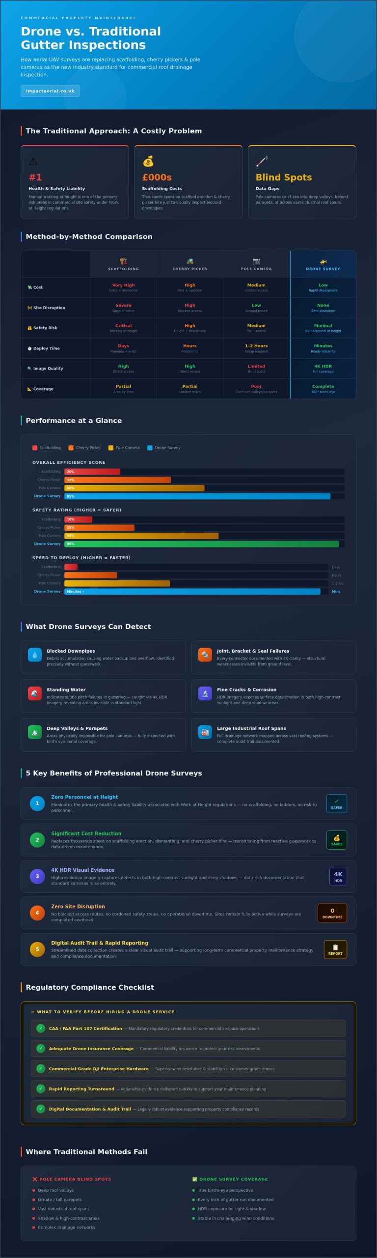
Why are you still authorizing thousands in scaffolding costs or cherry picker hire just to identify a few blocked downpipes? For many facility managers, the traditional approach to roof maintenance is a logistical headache that carries significant health and safety liabilities. You likely already know that manual working at height is a primary concern for site safety; it’s a risk that’s increasingly difficult to justify when a professional gutter inspection drone service offers a safer, more efficient alternative.

By utilizing these advanced aerial systems, you can transition from reactive guesswork to precise, data-driven maintenance. We understand that you need clear, actionable evidence of asset health without the operational downtime associated with traditional access methods. This article explores how commercial-grade drone surveys provide high-resolution visual evidence of gutter health without the site disruption of heavy machinery. We’ll examine the technical advantages of rapid aerial data collection, the importance of FAA Part 107 compliance for your risk assessments, and how rapid reporting turnaround helps you protect your property assets more efficiently.

Key Takeaways

  • Understand how aerial surveys eliminate the significant health and safety liabilities associated with manual working at height and traditional access methods.
  • Learn how a professional gutter inspection drone service captures high-resolution 4K data to identify critical defects that ground-based pole cameras frequently overlook.
  • Discover the financial benefits of replacing expensive scaffolding and cherry picker hire with rapid, zero-disruption aerial assessments.
  • Identify the mandatory regulatory credentials and insurance standards required to ensure your property surveys are fully compliant and legally robust.
  • Gain insights into how digital data collection streamlines reporting and provides a clear visual audit trail for long-term commercial property maintenance.

The Evolution of Gutter Inspections: Moving Beyond Scaffolding

Traditional gutter maintenance has long been synonymous with high-risk manual labor. For decades, property managers relied on ladders and scaffolding; they accepted the inherent liabilities as an unavoidable cost of doing business. However, the modern property sector is undergoing a significant transition toward non-disruptive data collection. This shift is driven by a need for higher precision and a desire to mitigate the safety risks outlined in current ‘Work at Height’ regulations, which significantly impact commercial maintenance budgets.

Central to this evolution is the Unmanned Aerial Vehicle (UAV), which has moved from a niche technology to a cornerstone of commercial asset management. A professional gutter inspection drone service now provides a level of detail that manual inspections simply can’t match, allowing for a comprehensive overview of complex drainage networks without putting personnel at risk.

To better understand how this technology is changing the landscape of property maintenance, watch this helpful video showing aerial capabilities in action:

Limitations of Traditional Access Methods

Manual inspections often involve significant logistical hurdles. Erecting scaffolding for a simple visual check is rarely cost-effective, yet skipping the check leads to expensive water damage. Mobile Elevated Work Platforms (MEWPs), or cherry pickers, offer more mobility but frequently cause disruption on active commercial sites. They block access and require cordoned-off safety zones that interfere with daily operations. Additionally, ground-based pole cameras are often physically limited. They struggle to see into deep valleys, behind ornate parapets, or across vast industrial roof spans. This leaves critical blind spots in your maintenance data, potentially hiding debris or structural failures until they become catastrophic.

The Rise of the Drone Survey

The adoption of a drone survey approach addresses these failings by providing a true ‘bird’s eye’ perspective of the entire drainage system. Unlike mechanical equipment that takes hours to position, a drone can be deployed in minutes to capture 4K visual data. This speed doesn’t come at the expense of quality. Modern aerial platforms are designed to remain stable in challenging conditions, ensuring that every inch of a gutter run is documented with crystal-clear resolution. This meticulous methodology has established aerial data collection as the new industry standard for high-level building inspections, providing property owners with psychological comfort and tangible financial benefits.

How Drone Technology Transforms Gutter Data Collection

A professional gutter inspection drone service is a specialized application of UAV technology designed to capture high-definition 4K visual data of roof drainage systems. This isn’t merely about taking aerial photographs; it’s a meticulous process of asset documentation. By utilizing commercial-grade hardware, operators can identify structural weaknesses that are invisible from the ground. Precision is the primary objective. Modern aerial platforms allow us to document every joint, bracket, and seal with a level of clarity that was previously impossible without significant manual effort.

The stability of these systems is a critical factor in professional environments. We utilize DJI Enterprise drones because they offer superior wind resistance and flight stability compared to consumer-grade models. This ensures that even on exposed industrial sites or during blustery conditions, the camera remains perfectly still. We capture 4K HDR imagery to expose details in both high-contrast sunlight and deep shadows. This dynamic range is essential for spotting fine-line cracks, subtle corrosion, or the presence of standing water that indicates a subtle pitch issue in the guttering.

Precision Hardware for Property Professionals

Success in aerial surveying relies on the specific capabilities of the flight platform. We employ the DJI Mavic 3 Enterprise or similar platforms because they are equipped with omnidirectional obstacle avoidance sensors. These sensors act as a safety net, protecting the building’s facade and the drone during close-proximity maneuvers. Additionally, GPS-stabilized flight is a standard requirement for our operations. It allows for repeatable inspections; we can return to the exact coordinates months or years later to monitor the progression of a known defect, providing a consistent audit trail for maintenance records.

High-Resolution Deliverables

The output of a professional survey must be actionable. We provide 20MP+ still images that allow property managers to zoom in on granular details like perished gaskets or loose fixings. For a broader understanding of site health, 4K video flyovers are indispensable. These videos help teams visualize water flow patterns and identify potential blockages across vast roof areas. The integration of aerial filming drone techniques ensures that the footage is cinematic yet technically precise, making it easy for stakeholders to review findings. If you require a comprehensive assessment of your building’s exterior, our drone commercial property surveys provide the high-tier data needed for informed decision-making.

Advanced zoom capabilities further enhance site safety. By utilizing high-powered optical zoom, we can inspect delicate areas without flying dangerously close to the structure. This reduces the risk of prop-wash disturbing loose debris and ensures the aircraft maintains a safe standoff distance at all times. The result is a comprehensive data set that serves as a professional foundation for your maintenance strategy.

Professional Gutter Inspection Drone Service: Safer, Faster Data Collection

Comparing Gutter Inspection Methods: ROI and Efficiency

The financial justification for adopting a professional gutter inspection drone service rests on the transition from subjective observation to objective data. Traditional methods often rely on a contractor’s verbal report after they’ve spent hours on a ladder or a cherry picker. This approach is inherently limited by what the individual can see at that moment. In contrast, aerial surveys provide a permanent, high-resolution digital record that can be reviewed by multiple stakeholders, including insurance adjusters and structural engineers, without anyone needing to leave the ground.

Efficiency is measurable in time and labor. A standard drone roof and gutter inspection typically takes between 30 and 60 minutes to complete. This is a significant improvement over manual inspections, which frequently require 2 to 4 hours of on-site labor plus the time needed to transport and set up heavy access equipment. For property managers overseeing multiple assets, these time savings translate directly into reduced operational costs and faster maintenance cycles.

Speed and Versatility on Site

A primary advantage of aerial technology is its ability to navigate complex site layouts with ease. We can complete a full perimeter inspection of a large industrial unit in a single morning, a task that would take days if scaffolding were required. Drones access confined areas and high-reach points that are physically impossible for mechanical platforms to reach safely. Because the aircraft is battery-powered and launched from a small designated area, there’s no heavy machinery to damage lawns, block car parks, or disrupt pedestrian flow. This minimal footprint makes it the ideal choice for active commercial environments where business continuity is a priority.

Actionable Maintenance Reports

The value of a survey extends far beyond the day of flight. Digital data serves as robust evidence for insurance documentation and claim support. Insurance companies are increasingly accepting and often preferring drone inspection reports because they provide unambiguous visual proof of an asset’s condition. By using this high-resolution imagery, multi-site managers can prioritize their maintenance spend based on actual urgency rather than a fixed schedule. This strategic approach prevents minor blockages from becoming major structural issues.

  • Historical Auditing: We create a visual record that allows you to track gutter degradation over several years.
  • Budget Optimization: Identify exactly which sections of a property portfolio require immediate attention.
  • Risk Mitigation: Eliminate the primary cause of workplace falls by keeping personnel on the ground.

Beyond the financial and safety benefits, the environmental impact is a factor that modern businesses can’t ignore. Battery-powered UAVs have a negligible carbon footprint compared to the diesel-powered engines of MEWPs and transport trucks. This allows your facility management team to maintain high standards of building health while aligning with corporate sustainability goals. It’s a cleaner, faster, and more precise way to manage property assets.

Compliance and Safety: Hiring a Professional Drone Service

Selecting a gutter inspection drone service involves more than just evaluating camera specifications. In the UK, the legal framework governing Unmanned Aircraft Systems (UAS) is rigorous, and failing to verify a pilot’s credentials can leave a property manager liable for significant fines or uninsured damages. Hiring a hobbyist or an uncertified pilot for commercial work isn’t just a shortcut; it’s a professional risk that compromises site safety and legal standing. Professional operators treat every flight as a controlled aviation exercise, ensuring that data collection never comes at the expense of safety.

The distinction between a casual flyer and a professional lies in their adherence to officialdom and risk mitigation. For any commercial property survey, a minimum of £5 million commercial liability insurance is the industry standard. This coverage protects the client, the public, and the property itself in the unlikely event of an incident. Without this specific commercial-grade protection, any damage caused during a survey could become a direct financial burden on the property owner.

Navigating UK Drone Regulations

Understanding the current drone license requirements is essential for anyone procuring aerial services. In 2026, the General Visual Line of Sight Certificate (GVC) is the critical qualification for pilots operating in congested commercial environments. This certification demonstrates that the pilot has undergone formal theoretical and practical assessments approved by the Civil Aviation Authority (CAA). It grants the operator the legal right to fly in urban areas or near high-traffic zones where airspace restrictions are complex.

Privacy is another pillar of professional compliance. Meticulous operators ensure full GDPR adherence when filming near residential windows or sensitive commercial boundaries. This involves pre-flight notifications and post-production techniques to redact any unintended personal data, ensuring your maintenance audit doesn’t infringe on privacy laws.

Risk Mitigation and Insurance

Every professional mission begins long before the drone leaves the ground. We conduct thorough pre-flight site surveys to identify local hazards, such as overhead power lines, nesting birds, or nearby restricted airspace. This preparation is documented in a formal risk assessment that serves as a foundation for a safe mission. You should always request to see a pilot’s policy documents and CAA Operational Authorisation before work commences. Commercial drone insurance policies typically remain valid only when the operator is in full compliance with CAA regulations and holds the appropriate flight authorizations.

By prioritizing these standards, you protect your business from the operational and legal failures associated with unregulated flight. If you need a fully compliant, high-resolution assessment of your facility’s drainage system, you can trust our drone commercial property surveys to deliver professional results within a safe, regulated framework.

Impact Aerial: Expert Gutter Surveys and Data Analysis

Impact Aerial operates with a meticulous focus on quality and regulatory compliance. Based in the West Midlands, we provide specialized property data collection that goes beyond basic photography. Our drone services are designed to integrate seamlessly into your existing maintenance workflows, providing a technical foundation for long-term asset protection. We understand that property managers require more than just a bird’s eye view; they need a reliable partner who understands the operational complexities of commercial site management.

Our approach is rooted in technical precision. We don’t just fly; we conduct a systematic audit of your building’s drainage health. This involves capturing high-resolution data that identifies immediate risks while documenting the overall condition of the asset. By integrating gutter inspections with our broader drone commercial property surveys, we offer a holistic view of building envelopes that helps facility managers stay ahead of costly repairs. This proactive methodology ensures that your maintenance budget is allocated where it’s needed most, based on empirical evidence rather than guesswork.

Beyond the Flight: Data Management

We address a common industry weakness by prioritizing professional post-production and data management. Raw footage is often difficult for maintenance teams to interpret without context. To solve this, our team processes every survey into a structured, high-resolution digital file set. We provide annotated imagery that highlights specific defects, such as perished seals or localized debris buildup, directly on the photographs. This consultative approach helps you interpret aerial data for accurate budget planning and ensures that your on-site teams have clear, visual instructions for any necessary repairs. Our secure delivery system ensures that all stakeholders can access this critical data quickly and efficiently.

Specialised Survey Solutions

The versatility of our fleet allows us to offer specialized solutions tailored to your specific infrastructure. We can combine visual gutter inspections with thermal data collection to identify hidden moisture ingress or assess the efficiency of rooftop energy assets. This is particularly beneficial for sites requiring PV solar farm thermal surveys alongside standard roof maintenance. We also support construction site monitoring during project handovers, providing definitive, high-resolution proof that gutters are clean and clear before a building is officially transferred to the client. If you require a professional, data-centric gutter inspection drone service, request a consultation with our expert team to discuss your site’s specific requirements and ensure your assets are protected by industry-leading aerial technology.

Future-Proofing Your Property Maintenance Strategy

Transitioning to a professional gutter inspection drone service is no longer just a technological upgrade; it’s a strategic necessity for modern facility management. By eliminating the high costs and safety liabilities of manual access, you can secure high-resolution data that drives more accurate maintenance decisions. You’ve seen how aerial technology provides a clear audit trail and superior ROI for complex commercial portfolios. This shift toward data-centric surveying ensures that minor blockages don’t evolve into structural failures.

Ready to upgrade your site assessments? Request a Professional Drone Gutter Survey Quote from our expert team. We operate with CAA GVC Certified Pilots and carry £5m Commercial Liability Insurance, utilizing DJI Enterprise Grade Hardware to ensure your data is as precise as it is compliant. We look forward to helping you protect your property assets with the precision and reliability your business requires.

Frequently Asked Questions

How long does a drone gutter inspection take?

A standard inspection for a commercial unit usually takes between 30 and 60 minutes on site. This is significantly faster than manual methods which can require several hours of labor and equipment setup. The speed is due to the rapid deployment of the UAV and its ability to traverse roof perimeters without the need to reposition heavy access machinery.

Can drones see blockages inside downpipes?

Drones cannot see through solid materials or navigate the interior of narrow downpipes. However, they are highly effective at identifying blockages at the hopper or entry point where most debris accumulates. By observing standing water or overflow patterns at these specific junctions, a pilot can accurately infer a blockage exists further down the drainage system.

Is a drone inspection as accurate as a manual check?

Aerial inspections often provide greater accuracy than manual checks because they capture high-resolution 4K data from angles a person on a ladder cannot safely reach. While a manual check allows for the physical testing of joints, the visual evidence provided by a professional gutter inspection drone service identifies cracks, corrosion, and perished gaskets with extreme precision.

Do I need to be present during the drone survey?

You don’t need to be present on site during the survey as long as our team has clear access to the exterior of the building. We conduct our pre-flight risk assessments and manage the entire flight operation independently. Once the data collection is complete, we process the 20MP+ imagery and deliver a comprehensive maintenance report directly to your digital inbox.

What happens if the drone crashes into my building?

We mitigate the risk of collisions through the use of omnidirectional obstacle avoidance sensors and strict flight safety protocols. In the highly unlikely event of an incident, our £5 million commercial liability insurance provides full protection for your property and assets. This level of coverage is a mandatory standard for all our professional property survey operations.

Can you fly a drone for gutter inspections in the rain?

We typically avoid flying in active rain to ensure the highest image quality and protect the aircraft’s sensitive electronics. Water droplets on the camera lens can distort the 4K imagery, making it difficult to spot fine-line defects or subtle corrosion. We monitor weather forecasts closely and will reschedule to the nearest clear window to maintain the integrity of your data.

Are there any buildings where a drone cannot be used for inspection?

Drones can be restricted in certain high-security zones or near major airports where flight permissions are denied by the CAA. Additionally, extremely confined spaces or areas with high electromagnetic interference may pose operational challenges. We verify every site’s airspace status during our pre-flight planning phase to confirm if a professional gutter inspection drone service is viable for your specific location.

How much does a professional drone gutter survey cost?

The cost of a professional survey depends on the scale of the property and the complexity of the roof structure. Factors such as site location, the number of separate buildings, and specific reporting requirements will influence the final project fee. We provide bespoke quotes for each project to ensure you only pay for the specific data and analysis your facility management team requires.

Drone Survey for Health and Safety Compliance: The 2026 UK Guide

According to the Health and Safety Executive (HSE), falls from height accounted for 33% of all workplace fatalities in Great Britain during the 2023/24 period. You likely agree that sending personnel onto fragile roofs or complex scaffolding is the most stressful part of your site management routine. It’s a high-stakes gamble that often leads to soaring insurance premiums and sluggish project timelines. By integrating a professional drone survey for health and safety compliance, you can eliminate these “working at height” risks entirely while maintaining a meticulous digital record for your stakeholders.

This 2026 guide reveals how CAA GVC certified aerial inspections help you achieve a zero-harm environment and ensure full compliance with CDM 2015 regulations. We promise to show you how high-precision data gathering provides the audit-ready evidence needed to lower your liability and provide total peace of mind during HSE inspections. You will get a clear look at the specific technologies, from thermal sensors to photogrammetry, that are currently replacing traditional MEWPs to deliver faster and safer site oversight across the UK.

Key Takeaways

  • Understand how modern aerial technology replaces high-risk manual inspections by eliminating human error and physical blind spots in complex industrial environments.
  • Learn how to align time-stamped visual data with CDM 2015 regulations to maintain an audit-ready Health and Safety File for your project.
  • Discover how a professional drone survey for health and safety compliance mitigates “working at height” risks by removing the need for manual roof walks and fragile surface exposure.
  • Identify the strategic steps for implementing safety-focused aerial monitoring into your management system, from defining high-risk KPIs to setting survey frequencies.
  • Recognise why hiring CAA GVC certified pilots with £5m commercial liability insurance is essential for maintaining professional standards and providing added peace of mind.

The Evolution of Site Inspections: Why Traditional Methods Fall Short of 2026 H&S Standards

In 2026, the definition of a drone survey for health and safety compliance has evolved from a novel technological perk to a critical requirement for high-risk industrial sites. Traditional manual inspections rely on human physical presence in hazardous zones, which introduces variables like fatigue and oversight. A technician climbing a ladder or traversing a roof can’t match the 4K precision and comprehensive coverage of an aerial platform. These legacy methods often result in blind spots where structural defects remain hidden until they cause a failure. By removing the human element from the initial data-gathering phase, companies can eliminate the primary risks associated with site assessments.

The Health and Safety Executive (HSE) continues to prioritise the reduction of “Working at Height” incidents, as falls remain the leading cause of workplace fatalities in the UK. In the 2023/24 reporting period, 50 workers lost their lives due to falls from height, a statistic that underscores the urgent need for remote inspection alternatives. Adhering to UK drone regulations ensures that these aerial operations are conducted within a strict legal framework, providing an objective “single source of truth” for site safety that manual notes simply cannot replicate.

To better understand the practical application of these technologies in a safety context, watch this helpful video:

The High Cost of Traditional Access

Scaffolding and Mobile Elevated Work Platforms (MEWPs) introduce their own set of hazards, including equipment failure and the risk of falling objects. Setting up these structures is time-consuming and often requires site downtime, impacting project budgets and schedules. Manual inspections are typically periodic, often occurring once a month. This creates a time-lag issue where a site remains unmonitored for 29 days between checks, leaving windows of unmanaged risk. A drone can be deployed in minutes, providing real-time data without halting production or endangering personnel.

The 2026 Compliance Landscape

The industry has shifted from reactive safety measures to predictive monitoring. Modern safety management now demands digital twins—highly accurate 3D models of a site—to identify potential hazards before they manifest. Using a professional survey drone has become the industry standard for creating these assets. Integrating a drone survey for health and safety compliance into a site’s risk management plan provides the “peace of mind” that only meticulous, CAA-certified data gathering can offer. This digital-first approach ensures that safety protocols are based on current, high-resolution evidence rather than outdated manual reports.

  • Human Error: Eliminates the risk of inspectors missing defects due to fatigue or limited visibility.
  • Predictive Analysis: Uses historical aerial data to track structural degradation over time.
  • Cost Efficiency: Reduces the need for expensive, high-risk access equipment like cradles or scaffolding.

How Drone Surveys Ensure CDM Compliance and Audit Readiness

Meeting the legal obligations set out in the Construction (Design and Management) Regulations 2015 requires more than just paperwork; it demands a living, breathing record of site safety. By 2026, a drone survey for health and safety compliance has become the industry standard for creating this record. These surveys provide high-resolution, time-stamped visual data that integrates directly into the Health and Safety File, ensuring that every phase of the project is documented with precision. Utilising a drone survey for health and safety compliance ensures that the Principal Contractor can demonstrate due diligence with visual proof that exceeds standard requirements.

Audit-Ready Documentation

Traditional site notes often lack the granularity needed during a Health and Safety Executive (HSE) inspection. Geo-tagged aerial imagery provides indisputable evidence of site conditions at a specific GPS coordinate and time. This data is far more robust in legal proceedings than manual logs. By using historical site comparisons, H&S Officers can track safety improvements over a six-month period, proving a proactive approach to risk. Automated reporting features now reduce administrative workloads by 40%, allowing safety teams to focus on site presence rather than data entry. Cloud-based safety maps ensure that all stakeholders see the same high-resolution data, fostering transparency across the supply chain.

Reducing RIDDOR Reporting

Preventing accidents is the primary goal of the Reporting of Injuries, Diseases and Dangerous Occurrences Regulations (RIDDOR). Aerial data allows for early hazard detection that’s often invisible from the ground. Drones equipped with 4K sensors can identify structural weaknesses in scaffolding or failures in edge-protection systems before they lead to a fall from height. Thermal imaging plays a critical role in fire risk mitigation by identifying overheating electrical components or insulation failures in temporary site structures. A professional drone survey provides data that acts as a preventative legal shield by documenting rigorous safety checks. Validating Risk Assessments and Method Statements (RAMS) with real-time imagery ensures that planned safety measures are actually being implemented on the ground. For added peace of mind, site managers can review our full guide to see how these data sets streamline compliance.

Mitigating the “Working at Height” Risk: Drones vs. Traditional Access

Falls from height remain the primary cause of workplace fatalities in the UK. Health and Safety Executive (HSE) statistics for 2023/24 reveal that 50 workers lost their lives following a fall from height, accounting for 36% of all workplace deaths. Implementing a drone survey for health and safety compliance directly tackles this statistic by removing the human element from the hazard zone. Traditional access methods, such as scaffolding, cradles, or Mobile Elevating Work Platforms (MEWPs), require extensive setup and expose personnel to gravity-related risks for the duration of the inspection.

Fragile surfaces, including asbestos cement sheets and aged skylights, are responsible for roughly 20% of all fatal falls in the construction sector. Drones eliminate the need for physical “roof walks” or the installation of expensive safety netting. A CAA GVC certified pilot can capture centimetre-accurate data without a single foot touching a potentially brittle surface. We operate on a “Ground-First” principle; while our 4K HDR sensors are positioned at 50 metres to capture detail, our team’s boots stay firmly on the ground. This approach provides added peace of mind for site managers who are legally bound to follow the hierarchy of risk management.

Adhering to the Working at Height regulations isn’t just about ticking a box; it’s about active risk total avoidance where possible. By choosing aerial data-gathering over manual climbing, companies often see a 60% to 80% reduction in the time personnel spend in high-risk areas. This shift in methodology is a cornerstone of modern drone survey for health and safety compliance, ensuring that the most dangerous jobs are handled by replaceable technology rather than people.

Structural Integrity Inspections

Inspecting 60-metre chimneys, telecommunications pylons, or high-rise cladding no longer necessitates rope access teams. Our fleet utilizes 4K HDR zoom capabilities to scrutinize bolts, welds, and masonry from a safe standoff distance. This is especially critical for unstable structures or confined spaces where human entry might trigger a collapse or expose workers to atmospheric hazards. We provide high-quality visual evidence that allows engineers to make informed decisions without ever leaving the safety of the site office.

Environmental and Terrain Safety

Drones serve as a vital tool for mapping unstable ground or flood risks before heavy machinery enters a site. In 2025, UK tier-one contractors reported a 15% increase in the use of aerial monitoring to manage pedestrian and vehicle segregation. If a site incident occurs, drones play a pivotal role in post-incident investigations. They allow safety officers to document the scene from a bird’s-eye perspective, ensuring a safer recovery process by identifying secondary risks that aren’t visible from the ground level.

Implementing Drone Data into Your Health and Safety Management System

Integrating a drone survey for health and safety compliance into your existing workflows requires a structured approach to ensure data remains actionable rather than just visual. To get the most from your aerial assets, follow these four implementation steps.

  • Step 1: Define Safety KPIs. Map out high-risk zones such as leading edges, crane swing radiuses, and hazardous material storage areas. Use GIS overlays to monitor these specific coordinates consistently.
  • Step 2: Establish Capture Frequency. On active UK construction sites, data from 2025 suggests that 78% of Tier 1 contractors now opt for weekly captures to track rapid site changes. Stable environments might only require monthly updates for audit purposes.
  • Step 3: Software Integration. Upload high-resolution orthomosaic maps directly into platforms like Procore or HammerTech via API. This ensures your safety team accesses the same “single source of truth” as the site engineers.
  • Step 4: Data Interpretation Training. Ensure your H&S leads can distinguish between topographical features and potential hazards within a 3D point cloud or photogrammetry model.

Interactive Site Inductions

Modern site inductions have evolved beyond static slide decks. By using 3D models generated from a drone survey for health and safety compliance, you can provide contractors with virtual walk-throughs before they ever step onto the live site. This enhances situational awareness by showing exact hazard locations in high-definition. A 2025 review of UK infrastructure projects showed a 15% reduction in “near-miss” incidents when teams used 3D aerial briefings during morning tool-box talks.

Real-Time Compliance Monitoring

Aerial data allows for the objective validation of site safety measures. You can verify that hoarding is secure and safety signage is visible from every site entrance without manual inspections. While spotting PPE non-compliance from 40 metres is technically possible with 4K zoom lenses, ethics remain a priority. Our operations adhere strictly to UK GDPR and the Information Commissioner’s Office (ICO) guidelines on surveillance. We focus on systemic safety gaps rather than individual worker monitoring. This approach provides added peace of mind for both management and the workforce.

Ready to upgrade your site safety protocols with precision data? Contact Impact Aerial for professional drone survey services.

Choosing a Compliant Partner: Why Impact Aerial Sets the Standard

Selecting a provider for a drone survey for health and safety compliance isn’t just about finding someone who can fly. It’s about rigorous risk mitigation. In the UK drone industry, 2026 regulations demand high levels of accountability and technical proficiency from every operator. Impact Aerial meets these demands through a combination of elite certification, high-tier insurance, and industrial-grade technology.

We only deploy CAA GVC certified pilots for commercial site work. This General Visual Line of Sight Certificate is the essential benchmark for operating safely in complex environments. Beyond basic licensing, we maintain £5 million in commercial liability insurance as our absolute minimum. While some hobbyist-turned-pro operators might offer lower cover, £5 million is the standard required by major UK construction firms and Tier 1 contractors. It provides the peace of mind that your business is protected against the unforeseen.

Our commitment to reliable data-gathering relies on our fleet of DJI Enterprise hardware. These aren’t consumer gadgets. They are professional tools featuring dual-redundancy systems and high-accuracy sensors. We don’t just show up and fly; we follow a meticulous flight planning process that identifies every site hazard before the props even spin. This structured approach ensures that every drone survey for health and safety compliance we conduct is repeatable, accurate, and, above all, safe.

Expertise in the West Midlands and Beyond

Based in Birmingham, Impact Aerial provides deep local knowledge across the West Midlands while maintaining the capacity for national reach on large-scale infrastructure projects. We’ve built a reputation across the property, construction, and building sectors for delivering professional services that go beyond simple photography. Our team manages the entire lifecycle of the survey. We handle the CAA-approved flight planning, the on-site execution, and the complex post-production data analysis. This end-to-end service ensures that the insights you receive are ready for immediate integration into your H&S files.

Start Your Safer Site Journey

Every construction site or industrial facility faces unique hazards. We don’t offer generic packages because compliance doesn’t work that way. You can request a safety-focused drone survey consultation where we’ll evaluate your specific site challenges. Whether you need high-resolution thermal imaging or 3D photogrammetry for stockpile management, we customise our data delivery to fit your H&S reporting needs. Contact Impact Aerial to discuss your H&S compliance requirements and discover how our aerial intelligence can make your site safer and more efficient today.

Future-Proofing Your Site Safety for 2026 and Beyond

Transitioning to a digital-first safety strategy isn’t just about efficiency; it’s about meeting the rigorous HSE expectations set for the 2026 landscape. By removing the need for physical access to hazardous areas, a drone survey for health and safety compliance directly addresses the risks associated with the 40 fatal falls reported by the HSE in 2022/23. You’re no longer relying on subjective manual inspections. Instead, you gain high-fidelity 4K HDR DJI Enterprise data that provides an indisputable audit trail for CDM 2015 regulations.

Impact Aerial delivers the meticulous standards required for high-stakes construction and infrastructure environments. Our CAA GVC Certified Pilots operate with £5m commercial liability insurance, giving you total peace of mind during every deployment. We provide the technical precision needed to integrate aerial insights directly into your existing health and safety management systems. Don’t leave your compliance to chance or outdated access methods that increase your site’s liability profile.

Book a Professional Drone Safety Survey with Impact Aerial to secure your site’s future. It’s time to elevate your safety standards with the industry’s leading aerial specialists.

Frequently Asked Questions

How do drone surveys specifically improve health and safety on a construction site?

Drone surveys eliminate the need for personnel to work at height, which remains the leading cause of workplace fatalities in the UK. According to HSE statistics for 2023/24, falls from height accounted for 35% of all fatal accidents at work. By using a drone survey for health and safety compliance, you remove the human risk from high-access inspections. This proactive approach ensures your site stays compliant while keeping your workforce safely on the ground.

Are drone surveys recognised by the HSE for compliance purposes?

The HSE acknowledges and encourages the use of remote technology to mitigate risks under the Work at Height Regulations 2005. These regulations state that work at height should be avoided if the task can be performed safely by other means. A drone survey for health and safety compliance provides high-definition, timestamped evidence that meets the rigorous documentation standards required for safety audits. It’s a proven method for demonstrating “so far as is reasonably practicable” risk reduction.

Do I need to notify my insurance company if I use drones for inspections?

You should always inform your insurer, though professional drone operators provide their own specialist cover. Impact Aerial maintains commercial liability insurance that meets EC 785/2004 requirements, providing peace of mind for every project. While our insurance covers the flight operations, your site policy may need a quick review to ensure there aren’t specific exclusions for unmanned aircraft. Many UK insurers now view drone use as a risk-reduction measure, which can positively impact your premiums.

What qualifications must a drone pilot have to work on a commercial site in 2026?

Every commercial pilot must hold a valid CAA GVC (General Visual Line of Sight Certificate) to operate on UK construction sites. This certification ensures the pilot understands the latest UK Airspace regulations and safety protocols. For complex urban environments or sites near restricted areas, the operator must also possess a valid Operational Authorisation from the Civil Aviation Authority. We ensure all our pilots are fully vetted and carry up-to-date credentials for every deployment.

Can drones be used for health and safety inspections in indoor or confined spaces?

Specialised collision-proof drones allow for safe inspections inside tanks, silos, and crawl spaces. These caged drones use LiDAR and thermal sensors to navigate where GPS signals are unavailable. This technology removes the need for Confined Space Entry permits and the associated rescue teams. It’s a much safer way to inspect internal structural integrity without exposing staff to hazardous atmospheres or restricted movements.

How long does it take to get the safety data back after a drone survey?

Initial high-resolution imagery and raw video footage are typically available for review on the same day as the flight. For more complex outputs, such as 3D point clouds or orthomosaic maps, the data-gathering and processing cycle usually takes 24 to 48 hours. This rapid turnaround allows site managers to identify and rectify potential safety hazards much faster than traditional manual inspection methods. Speed doesn’t compromise quality; it enhances your ability to react to site risks.

What is the cost difference between a drone survey and traditional scaffolding for H&S?

A drone survey can be up to 70% cheaper than traditional access methods like scaffolding or powered access platforms. For example, erecting scaffolding on a medium-sized commercial building in the UK often costs upwards of £1,500 before any inspection even begins. A drone can complete the same visual assessment in a single morning for a fraction of that price. You save money on equipment hire, labour hours, and the potential downtime associated with site obstructions.

How does drone data integrate with my existing H&S software?

We provide data in universal formats that plug directly into your existing management systems. High-resolution JPEGs and 4K videos work with standard reporting tools, while more technical data integrates with BIM software and platforms like Procore or Autodesk. This seamless integration means your health and safety records are updated with precise, visual evidence. It simplifies the process of tracking site changes and maintaining a clear audit trail for regulatory bodies.

Alternatives to Cherry Picker Inspections: Why Drones are the Future of Working at Height

Why are you still paying upwards of £600 per day to hire a machine that puts your staff at risk and limits your field of vision? For many UK site managers, the traditional approach to high-level surveys involves significant operational downtime and the inherent danger of manual visual checks. We agree that maintaining your assets is non-negotiable, yet the logistical burden of hiring Mobile Elevated Work Platforms (MEWPs) often outweighs the results. If you are looking for more efficient alternatives to cherry picker inspections, it is time to look towards the sky.

By reading this guide, you’ll discover how professional drone surveys provide a safer, faster, and more cost-effective solution for your business. We provide peace of mind by keeping your boots on the ground while our fleet of 4K DJI Enterprise drones captures every detail with precision. We will examine how switching to aerial data-gathering can reduce your inspection costs by up to 70% and ensure your operations remain fully CAA GVC Certified and compliant. From identifying structural defects to providing top-quality photogrammetry, we’ll show you why the future of working at height is remote.

Key Takeaways

  • Understand why professional drone surveys are becoming the leading alternatives to cherry picker inspections by eliminating high rental costs and complex site access logistics.
  • Discover how commercial-grade DJI Enterprise drones can transition from arrival to full data capture in under 15 minutes, significantly reducing project downtime.
  • Learn how to mitigate the inherent risks of working at height by keeping personnel safely on the ground while capturing high-resolution 4K HDR inspection data.
  • Identify the critical legal requirements for UK operations and why hiring a CAA GVC certified pilot is essential for regulatory compliance and insurance validity.
  • Explore how detailed post-production aerial reports provide building managers with the technical insights needed for informed maintenance and total peace of mind.

The Limitations of Traditional Cherry Picker Inspections

For decades, Mobile Elevated Work Platforms (MEWPs) have been the industry standard for commercial building maintenance and structural surveys. An Aerial work platform provides physical access to difficult areas, yet the reliance on these mechanical solutions is shifting as asset managers seek more efficient alternatives to cherry picker inspections. While effective for hands-on repairs, using heavy machinery for simple visual assessments introduces unnecessary complexity and operational friction to a project. The logistical burden of moving several tonnes of equipment often outweighs the benefit of the inspection itself.

Traditional methods require significant lead times and precise site coordination. Accessing a roof or a high-level facade isn’t just about the height; it’s about the ground conditions, weight bearing capacities, and the physical footprint of the machinery. When a surveyor uses a basket for manual visual checks, they’re limited by their own line of sight and the physical reach of the boom. This often results in incomplete data sets and missed defects that are only visible from specific, difficult angles.

To better understand the traditional process and its requirements, watch this helpful video:

The High Cost of Access Equipment Hire

Hiring a cherry picker involves far more than the daily rental rate. In the UK, a standard 20-metre truck-mounted platform can cost between £400 and £700 per day, but hidden expenses quickly inflate the budget. You must factor in delivery and collection fees, which often exceed £150, alongside the mandatory requirement for a qualified IPAF operator. If the inspection takes place on a public highway, local council permits can cost upwards of £100 per day and require 10 to 14 days of advance notice. These logistical hurdles often turn a simple “quick check” into a multi-day operation that disrupts site productivity and drains resources.

Safety Risks and Regulatory Burdens

Operating heavy machinery at height brings significant administrative and safety responsibilities. The Work at Height Regulations 2005 mandate that work should only be performed at height if there is no other viable alternative. The Health and Safety Executive (HSE) prioritises a safety hierarchy where “boots on the ground” is always preferred to minimise fall risks. Beyond the physical danger, companies must manage strict compliance with LOLER (Lifting Operations and Lifting Equipment Regulations) for the machinery. Even for hired equipment, the user must ensure PUWER (Provision and Use of Work Equipment Regulations) standards are met. Manual inspections also suffer from human error; a surveyor in a basket cannot capture the same level of granular, repeatable data that modern digital sensors provide. This makes the search for alternatives to cherry picker inspections a matter of both safety and data integrity.

Why Drones are the Leading Alternative for Working at Height

Commercial-grade DJI Enterprise drones have redefined the standards for industrial surveys across the West Midlands and the wider UK. Unlike traditional methods that require heavy plant hire and complex logistics, a CAA GVC certified pilot can arrive on-site and have a drone airborne in under 15 minutes. This rapid deployment makes drones the most efficient alternatives to cherry picker inspections for time-sensitive projects, especially when weather windows are narrow. The speed of data capture doesn’t just save time; it ensures that maintenance teams get actionable insights hours, or even days, faster than traditional methods allow.

Drones excel where traditional MEWPs (Mobile Elevated Work Platforms) fail. They navigate tight gaps between urban structures or hover over fragile roof surfaces where a cherry picker’s weight would cause significant structural damage. Safety is the primary driver for this shift. By keeping personnel firmly on the ground, operators align with OSHA guidelines on drone inspections which advocate for the use of unmanned systems in hazardous or inaccessible areas. Every flight creates a permanent digital record. High-resolution imagery and GPS-tagged data ensure a robust audit trail, providing 100% repeatable results for year-on-year comparisons that manual logbooks cannot match.

Superior Visual and Technical Data

Our fleet captures 4K HDR imagery, allowing surveyors to identify hairline cracks or minor defects in masonry from a safe distance. Integrated thermal sensors identify heat loss and moisture ingress in flat roofs that are often invisible to the naked eye. Photogrammetry is the process of creating 3D models from drone data. These technical outputs provide a level of precision that justifies the shift away from manual surveys. For clients requiring high-quality data for insurance or structural reports, professional drone services offer a depth of information that a visual check from a basket cannot provide.

Minimising Site Disruption

Traditional inspections often require cordoning off 20 or more car parking spaces or closing public pavements to accommodate heavy machinery. Drones operate within a much smaller footprint, usually requiring only a 5-metre exclusion zone for take-off and landing. The electric motors provide near-silent operation, which is vital for occupied residential blocks or quiet office environments in city centres. Switching to drones also reduces the carbon footprint of an inspection by eliminating the need for 5-tonne diesel-powered machinery on-site. This makes the process cleaner, quieter, and significantly less intrusive for building occupants and the local community.

Drones vs. Cherry Pickers: A Comparative Analysis

Traditional access methods like Mobile Elevated Work Platforms (MEWPs) involve significant logistical hurdles. For a standard 30-metre inspection, a cherry picker requires transport to the site, ground stabilization, and often local authority permits for pavement closures. This setup process can consume 3 to 4 hours before an inspector even reaches the roofline. By contrast, a CAA GVC certified pilot can deploy a commercial drone and begin capturing data in under 20 minutes. This rapid deployment makes UAV technology one of the leading alternatives to cherry picker inspections for both scheduled maintenance and emergency fault finding.

Safety and Risk Mitigation

The Health and Safety Executive (HSE) reported that falls from height accounted for 40 workplace fatalities in Great Britain during 2022/23. It remains the primary cause of workplace deaths in the UK. Transitioning to drone technology eliminates this risk by keeping all personnel safely on the ground. Insurance providers are increasingly favouring drone-based surveys because they drastically reduce the liability profile of a project. Impact Aerial operates with £5m commercial liability insurance for added peace of mind, ensuring every flight is backed by robust protection and professional accountability.

Efficiency and Scalability

Scalability is where drones provide a clear financial advantage over manual methods. A single pilot can complete high-resolution drone property surveys across an entire commercial estate in the time it takes to move and restabilise a single cherry picker. On active builds, construction site monitoring via drone doesn’t require shutting down heavy plant machinery or clearing ground-level exclusion zones. This allows the site to remain productive while the inspection is carried out. This streamlined workflow is a key reason why many UK firms are moving away from traditional access equipment.

Data longevity is another critical factor. While manual inspections often rely on handwritten notes and subjective observations, drones capture 4K HDR imagery and 45MP stills. This data is stored in secure cloud-based galleries, creating a permanent, timestamped digital record. Building managers can compare high-resolution imagery from 2024 with 2025 to track the exact rate of masonry degradation or guttering wear. This level of precision provides a data-driven foundation for long-term asset management that traditional alternatives to cherry picker inspections cannot replicate.

The transition from manual to digital also eliminates the inconsistencies of human memory. Instead of a technician describing a crack in a chimney stack, the drone provides a sub-centimetre resolution image that can be shared instantly with structural engineers. This digital-first approach ensures that every stakeholder has access to the same high-quality visual evidence, regardless of where they are located.

Transitioning to Drone-Based Inspections: Compliance & Safety

Adopting drones as alternatives to cherry picker inspections requires more than just purchasing hardware. The UK regulatory environment is strictly governed by the Civil Aviation Authority (CAA). Operating commercially without the correct permissions isn’t just risky; it’s illegal. For added peace of mind, every flight we conduct follows a rigorous pre-flight protocol. This includes site-specific risk assessments (RAMS), checking for restricted airspace, and obtaining necessary landowner permissions. Urban inspections add another layer of complexity. We manage data protection and GDPR considerations by ensuring that any identifiable human data is either avoided or redacted during the post-production phase. Professional operators must maintain a clear log of data handling to ensure compliance with the Data Protection Act 2018.

The Importance of CAA Certification

You’ll often see hobbyists with an A2 CofC, but for complex commercial building surveys, a GVC (General Visual Line of Sight Certificate) is the standard you should demand. The GVC is a more rigorous UK drone license that allows pilots to operate in more congested areas under specific operational authorisations. Impact Aerial maintains full compliance with the latest 2026 CAA regulations. This ensures that your project isn’t delayed by legal challenges or safety breaches. Professional certification is a non-negotiable requirement for any site manager or building owner looking to mitigate liability. It proves the pilot has undergone formal flight examinations and understands emergency procedures.

What to Look for in a Drone Service Provider

When evaluating alternatives to cherry picker inspections, vetting a professional drone service involves more than checking a price list. You need to verify that the provider uses enterprise-grade equipment. Consumer-level drones lack the sensor resolution and thermal capabilities required for high-accuracy defect detection. A professional fleet should include drones equipped with high-resolution 4K or 45MP sensors and radiometric thermal cameras. Check their post-production capabilities too. A stack of raw images is rarely useful for a facilities manager. You need a provider who delivers annotated high-resolution reports identifying specific defects rather than just a folder of photos.

  • Verification of a valid CAA Operational Authorisation for the specific mission profile.
  • Proof of specialist commercial liability insurance with a minimum £5 million cover.
  • Use of cloud-based platforms for easy data sharing and stakeholder collaboration.
  • The ability to provide photogrammetry models for precise, millimetre-accurate measurements.

If you’re ready to upgrade your surveying process, contact our specialist team to discuss your requirements.

Professional Drone Inspection Services with Impact Aerial

Impact Aerial delivers a comprehensive suite of professional drone services across Birmingham, the West Midlands, and the wider UK. We provide one of the most efficient alternatives to cherry picker inspections, allowing site managers to bypass the logistical headaches of hiring platform lifts or erecting complex scaffolding. Our end-to-end process is built on transparency. It starts with an initial consultation to define your survey goals, followed by meticulous flight planning and risk assessment. After the flight, we deliver detailed post-production reports that include high-resolution imagery and actionable data that engineers can use immediately.

Our specialist applications cover demanding sectors like renewable energy and commercial real estate. We conduct PV solar farm thermal surveys to detect hotspots or failing strings, ensuring maximum energy yield for plant operators. For commercial roof inspections, our drones capture every detail of large-scale industrial units, from guttering to HVAC systems, in a fraction of the time a manual team would require. For added peace of mind, every pilot is CAA GVC Certified and we carry £5 million in commercial liability insurance. We’ve established ourselves as a trusted specialist in this niche but increasingly diverse market through consistent reliability.

Our Technology and Expertise

Our fleet features the latest 4K High Dynamic Range (HDR) DJI Enterprise drones, designed for both stability and clarity. We bridge the gap between aerial filming drone aesthetics and technical survey precision. This means you receive breath-taking results that are also functionally useful for structural engineers and surveyors. The high-resolution sensors allow our team to zoom into specific bolts, cracks, or welds while maintaining crisp detail. It’s this commitment to quality that ensures our data-gathering meets the highest industry standards for 2025 and beyond.

Get a Quote for Your Next Inspection

Getting a quote for your project is straightforward and fast. Simply provide us with your site postcode and a brief description of the assets requiring inspection. We use advanced satellite mapping to assess the site remotely, allowing us to provide a transparent quote within 24 hours. Impact Aerial is the preferred partner for property professionals and developers who value safety and technical excellence. Contact Impact Aerial today for a safer alternative to cherry pickers and experience the future of working at height.

Future-Proof Your Asset Management Strategy

Adopting drone technology transforms how you manage high-level assets. You’ll reduce operational downtime and eliminate the physical risks associated with manual climbing or heavy machinery. These systems deliver 4K high-resolution data faster than traditional access platforms, providing a clearer picture of structural health. As businesses prioritise safety and efficiency, drones have become the leading alternatives to cherry picker inspections for forward-thinking firms.

Impact Aerial delivers expert survey solutions across Birmingham and the West Midlands. Our team consists of CAA GVC Certified pilots who operate under the latest UK aviation regulations. For added peace of mind, we maintain £5m commercial liability insurance, ensuring your project is protected from every angle. It’s time to swap expensive rentals for precision-engineered data gathering that keeps your team’s feet firmly on the ground.

Request a professional drone survey quote from Impact Aerial to start your transition to safer, more efficient aerial inspections.

Frequently Asked Questions

Are drones a legal alternative to cherry picker inspections in the UK?

Drones are a fully legal alternative to cherry picker inspections in the UK when operated by CAA GVC certified pilots. We operate strictly within the Civil Aviation Authority (CAA) framework and follow CAP 722 safety guidelines at all times. For added peace of mind, our professional services are backed by £5 million in commercial liability insurance, ensuring every flight meets the highest regulatory standards.

How much can I save by switching from a cherry picker to a drone survey?

Switching to drone surveys can reduce your inspection costs by 30% to 65% compared to traditional plant hire. You eliminate the £400 to £1,200 daily rental fees for a 20-metre cherry picker and the associated transport costs. Since a drone team typically completes a site survey in 90 minutes, you also avoid the expensive labour hours required for manual height work.

Can a drone inspect a roof as thoroughly as a person in a basket?

Modern drones equipped with 4K HDR sensors provide a more comprehensive view than a person standing in a mechanical basket. Our DJI Enterprise fleet captures high-resolution imagery and thermal data that detects moisture or heat loss invisible to the naked eye. We provide a 100% digital record of the entire roof surface, ensuring no tile or flashing is missed during the data-gathering process.

What happens if the weather is bad on the day of the drone inspection?

If wind speeds exceed 20mph or heavy rain occurs, we reschedule the flight to ensure the safety of the site and equipment. Our pilots monitor Met Office forecasts and specialized aviation apps 24 hours before deployment. This flexibility is a key benefit of alternatives to cherry picker inspections, as there are no wasted plant hire fees if the weather prevents a flight.

Do I need to notify my neighbours or local council before a drone inspection?

You typically don’t need council permission for drone flights on private property, but we manage all necessary notifications as part of our service. We adhere to the UK Data Protection Act and the UK GDPR to ensure privacy for neighbouring residents. If the site falls within a Flight Restricted Zone, we coordinate directly with Air Traffic Control to secure the required flight permits.

What kind of report will I receive after a drone-based inspection?

You receive a detailed technical report containing high-definition 4K images, 20-megapixel close-ups, and optional 3D photogrammetry models. We provide these assets via a secure cloud link within 48 hours of the site visit. This documentation allows your maintenance team to zoom in on specific defects, such as hairline cracks or loose mortar, with extreme precision from their desktop.

Is a drone survey suitable for listed buildings or sensitive sites?

Drones are the safest option for listed buildings because they require zero physical contact with the structure. Traditional access methods like scaffolding or cherry pickers risk damaging fragile stonework or historic lead roofing. Our non-intrusive approach is frequently preferred by conservation officers for monitoring Grade I and Grade II listed sites without the vibration or weight of heavy machinery.

How high can a drone fly for an industrial chimney or tower inspection?

We can fly drones up to 120 metres (400 feet) above ground level for industrial chimney or tower inspections under standard CAA permissions. If your structure exceeds this height, we can apply for specific Operating Safety Cases to fly higher. This capability allows us to inspect the tallest structures in the West Midlands without the logistical nightmare of high-reach mechanical platforms.

Drone Roof Survey: A Safer, Faster & More Cost-Effective Inspection

For property managers and building owners, the prospect of a roof inspection often brings to mind the high costs of scaffolding, significant operational downtime, and the unavoidable safety risks of working at height. This traditional approach, however, is no longer the only option. A professional drone roof survey offers a modern, efficient alternative, transforming how we assess and maintain building envelopes without the need for costly access equipment or putting personnel in hazardous situations.

This comprehensive guide will explore how this innovative technology provides a safer, faster, and remarkably more cost-effective solution for your property. We will detail how our CAA GVC certified pilots utilise high-resolution imaging and advanced data-gathering techniques to deliver a level of detail that is simply unattainable from the ground. You will discover how a drone-based inspection minimises disruption, eliminates physical risks, and provides you with a clear, actionable report to make informed maintenance decisions with complete peace of mind.

What is a Drone Roof Survey? The Modern Alternative to Scaffolding

A drone roof survey is a professional inspection service that utilises a commercial-grade unmanned aerial vehicle (UAV), equipped with high-resolution cameras, to conduct a thorough aerial assessment of a roof’s condition. This modern data-gathering technique replaces traditional methods that often involve expensive scaffolding, hazardous ladders, or access platforms like cherry pickers. Instead of putting personnel at risk, a certified pilot can safely and systematically capture detailed imagery from multiple angles, providing a complete and accurate picture of the roof structure.

To see how this process works in practice, this short video provides an excellent overview of a typical drone inspection flight plan:

The core deliverable of a professional drone roof survey is a comprehensive report. This document contains detailed, high-resolution photographs and video footage, with any defects, potential issues, or areas of concern clearly annotated. This approach offers several key advantages over manual inspections:

  • Enhanced Safety: It completely eliminates the need for working at height, mitigating the most significant risk associated with traditional roof inspections.
  • Speed and Efficiency: A survey that might take days to complete with scaffolding can often be finished in a matter of hours, minimising disruption to the property.
  • Cost-Effectiveness: By avoiding the significant costs of scaffolding hire and labour, a drone survey can save clients hundreds, if not thousands, of pounds.
  • Superior Data Quality: The high-resolution data captured provides an unambiguous and permanent record of the roof’s condition, which can be easily shared with contractors, surveyors, or insurers.

Who Needs a Drone Roof Survey?

This professional service is invaluable for a wide range of clients who require accurate and timely roof condition data. Key stakeholders include:

  • Property and Facilities Managers for scheduled maintenance programmes and creating condition reports for large commercial portfolios.
  • Building Surveyors and Chartered Surveyors conducting due diligence, dilapidation reports, or structural assessments.
  • Homeowners seeking a fast, safe assessment after storm damage or before finalising a property purchase.
  • Construction Companies for monitoring project progress on new builds and creating snagging lists without disrupting site work.

The Technology Behind the Survey

Our professional services are powered by leading-edge technology to ensure the highest quality results. We operate commercial-grade DJI Enterprise drones, renowned for their stability and reliability. The key components of our survey equipment include:

  • High-Resolution 4K Cameras that capture crystal-clear visual data, allowing us to zoom in on potential defects like cracked tiles or failing flashing.
  • Optional Thermal Imaging Cameras to detect hidden issues such as water ingress, moisture build-up, or areas of significant heat loss not visible to the naked eye.
  • GPS and Automated Flight Planning Software which enables us to perform systematic, grid-based flights for complete and comprehensive coverage of the entire roof area.

Safety First: Eliminating the Dangers of Working at Height

Traditional roof inspections are inherently dangerous. According to the Health and Safety Executive (HSE), falls from height remain the leading cause of fatal accidents for UK workers. Every time an inspector climbs a ladder or steps onto scaffolding, they face significant risks, from slips and falls to the structural instability of the roof itself. A professional drone roof survey fundamentally changes this dynamic by removing the human element from the point of risk. Our operators remain safely on the ground, eliminating the potential for life-altering accidents.

This modern approach not only protects personnel but also safeguards the property. Fragile materials like slate, clay tiles, or aged asbestos sheeting can be easily damaged by foot traffic, leading to costly secondary repairs. Drones capture high-resolution data without ever making physical contact, preserving the integrity of your asset.

Traditional Method Risks vs. Drone Safety

The logistical and financial burdens of conventional access methods are significant. Drones offer a superior alternative by sidestepping these common challenges:

  • Scaffolding: Erecting scaffolding is expensive, time-consuming, and visually intrusive, often requiring permits and disrupting daily operations. In contrast, a drone survey is swift and discreet, providing a clear cost-effectiveness and financial advantage with minimal setup.
  • Ladders: While quick to deploy, ladders are notoriously unstable, offer limited reach, and place the inspector in a precarious position, restricting their ability to conduct a thorough examination.
  • Cherry Pickers (MEWPs): These require stable, level ground and clear access, making them unsuitable for many sites. They are also costly to hire and operate.

The Role of Professional Certification and Insurance

The safety of a drone roof survey is underpinned by rigorous professional standards. Hiring a pilot with a Civil Aviation Authority (CAA) General Visual Line of Sight Certificate (GVC) is non-negotiable for any commercial operation in the UK. This certification proves the operator is trained in safe flight procedures, risk mitigation, and aviation law. For added peace of mind, we carry comprehensive commercial liability insurance up to £5 million. Every mission begins with a detailed pre-flight risk assessment and operational plan, ensuring all potential hazards are identified and managed. Our certified pilots ensure every survey is safe and compliant. Learn about our process.

Unmatched Speed & Minimal Disruption

In property management and maintenance, time is a critical resource. Traditional methods of roof inspection, such as erecting scaffolding, can take days or even weeks to arrange and construct, causing significant operational delays and disruption. This process often involves cordoning off large areas, creating noise, and inconveniencing tenants or customers, all before a single tile has been inspected.

A professional drone roof survey fundamentally changes this dynamic. The entire on-site data capture is typically completed in just one to two hours, even for large or complex commercial buildings. There is no need for heavy equipment, road closures, or restricted access. Our CAA GVC certified pilots operate efficiently and discreetly, ensuring your business operations continue uninterrupted. This efficiency extends to data delivery, with initial high-resolution findings often available on the same day for urgent assessments.

The Drone Survey Process: From Enquiry to Report

Our process is designed for maximum efficiency and clarity, providing you with actionable data swiftly. Each step is handled with meticulous attention to detail to ensure safety and quality.

  • Step 1: Initial Consultation: We discuss your specific requirements and conduct a preliminary desktop assessment of the site to identify any potential airspace restrictions or hazards.
  • Step 2: On-Site Assessment & Flight: Our pilot arrives on site, conducts a thorough risk assessment, establishes a safe flight zone, and executes the pre-planned flight path.
  • Step 3: Comprehensive Data Capture: The drone captures high-resolution imagery and video of the entire roof structure, including gutters, chimneys, and flashing, from multiple angles to ensure no detail is missed.
  • Step 4: Processing & Reporting: The captured data is processed to create a detailed digital report, complete with annotated images and expert observations, delivered to you securely online.

How Drones Accelerate Project Timelines

The speed of a drone roof survey creates a powerful ripple effect across your entire project or maintenance workflow. By providing clear, comprehensive data almost immediately, you can accelerate crucial next steps. Roofers can provide more accurate quotes faster without needing a site visit, and insurance claims can be processed more quickly with indisputable photographic evidence of damage. This rapid insight also enables a proactive maintenance schedule, allowing for more frequent, cost-effective inspections to identify minor issues before they escalate into expensive structural problems.

Cost-Effectiveness: A Clear Financial Advantage

When evaluating the options for inspecting a roof, the financial implications are a primary consideration. A professional drone roof survey presents a compelling case not just for its technological superiority, but for its significant cost savings over traditional methods. This modern approach eliminates many of the substantial, and often hidden, costs associated with manual, at-height inspections, delivering a higher return on investment.

Breaking Down the Costs of Traditional Surveys

Manual roof inspections rely on expensive access equipment, with costs that quickly accumulate and often lack transparency. Consider the typical expenses in the UK:

  • Scaffolding Hire: A standard setup for a semi-detached house can easily cost between £900 and £1,500, factoring in erection, weekly hire, and dismantling fees.
  • Cherry Picker (MEWP) Rental: This option involves hourly rates (typically £75-£150 per hour), in addition to delivery charges and the cost of a certified operator.
  • Associated Costs: These methods may also require costly permits from local councils for pavement or road closures, adding another layer of expense and administration.

What’s Included in a Drone Roof Survey Cost?

In stark contrast, a drone survey is typically offered at a fixed, all-inclusive price, providing complete cost certainty from the outset. For a clear, one-off fee, our professional service includes the deployment of a fully insured, CAA GVC Certified pilot, the use of professional-grade drone and camera systems, and the subsequent data processing to create a detailed, actionable PDF report. This transparent model ensures there are no surprise charges.

Indirect Savings and Added Value

The financial benefits extend far beyond the initial quote. The true value lies in the long-term ROI and operational advantages. Early detection of minor issues-such as a cracked tile or failing flashing identified in high-resolution detail-can prevent them from escalating into major structural repairs costing thousands of pounds. For commercial properties, the minimal disruption means business can continue as usual, avoiding costly downtime. You also receive a permanent digital record of your roof’s condition, providing invaluable evidence for insurance claims and a stronger negotiating position with contractors. For a detailed, fixed-price quotation for your property, contact our team.

Superior Data: See Your Roof in Unprecedented Detail

A key advantage of a professional drone roof survey is the sheer quality and comprehensiveness of the data collected. Where a ground-based inspection is limited by perspective and access, our advanced drones capture a complete, high-resolution digital record of your entire roof structure. This allows for the meticulous inspection of every component, including hard-to-reach areas like complex roof valleys, chimney stacks, and high-level guttering, without the risks associated with working at height.

The result is not just a set of photographs, but a complete visual archive of your asset’s condition at a specific point in time. This data is invaluable for future reference, allowing for direct comparison to identify degradation over time. Our deliverables extend beyond raw imagery to include detailed, annotated reports and high-definition videos that clearly communicate our findings.

Visual Inspections with 4K High-Resolution Imagery

Our drones are equipped with commercial-grade 4K cameras and powerful zoom capabilities. This technology allows us to identify even minor defects with exceptional clarity, such as cracked tiles, loose flashing, damaged mortar, or blockages in guttering. We can also perform orthomosaic mapping, a process where hundreds of individual photos are digitally stitched together to create a single, high-resolution, top-down image of your roof. This provides clear, irrefutable evidence of any issues for inclusion in maintenance reports or quotes from contractors.

Advanced Data: Thermal Imaging and 3D Models

For a deeper diagnostic insight, we offer advanced data-gathering services. A thermal drone roof survey uses infrared sensors to detect temperature variations across the roof surface, identifying problems invisible to the naked eye. This is highly effective for locating hidden water ingress, pinpointing areas of trapped moisture beneath the roof membrane, and highlighting insulation gaps that lead to significant energy loss. Furthermore, using a technique called photogrammetry, we can generate a dimensionally accurate 3D model of your property for precise measurements and planning. Need more than just photos? Ask about our advanced data services.

Make the Smart Choice for Your Property’s Roof Inspection

The days of relying on costly, disruptive scaffolding and accepting the inherent risks of working at height are over. As we’ve detailed, aerial inspections offer a modern, superior alternative by delivering unmatched safety, remarkable speed, and significant cost savings. Choosing a professional drone roof survey is a direct investment in operational efficiency and the acquisition of high-resolution visual and thermal data that traditional methods simply cannot replicate.

At Impact Aerial, we provide this leading service for the property and construction sectors across the UK. For your complete peace of mind, all our operations are conducted by CAA GVC Certified and Fully Insured pilots. We utilise advanced 4K and thermal data capture technology to identify potential issues with pinpoint accuracy, delivering the detailed, actionable insights you need to make critical decisions about your assets.

Ready to see the difference for yourself? Get a fast, no-obligation quote for your professional drone roof survey. Take the first step towards a smarter, safer inspection for your property today.

Frequently Asked Questions About Drone Roof Surveys

How much does a drone roof survey cost in the UK?

The cost of a drone roof survey in the UK typically starts from around £250 for a small residential property and can increase to £1,000 or more for large or complex commercial buildings. The final price is influenced by factors such as the roof’s size, the complexity of the structure, and the level of detail required in the final report. For an accurate, no-obligation quotation, we recommend contacting us directly to discuss your specific requirements.

Are drone roof surveys accurate and reliable?

Yes, when conducted by a qualified professional, drone surveys are exceptionally accurate. Our commercial-grade drones are equipped with high-resolution 4K cameras and optional thermal imaging sensors, capturing precise data that is often superior to traditional methods. This technology allows for the clear identification of subtle defects, water ingress, or heat loss that might be missed from ground level, providing a comprehensive and verifiable record of the roof’s condition.

What kind of report do I receive after a drone roof survey?

Following the survey, you will receive a comprehensive digital report package. This includes a portfolio of high-resolution still images, 4K video footage, and a detailed PDF document. The written report highlights key findings, with images annotated to pinpoint specific areas of concern such as damaged tiles, blocked gutters, or potential leaks. This provides you with clear, actionable data to inform maintenance decisions and share with roofing contractors or insurers.

Do I need to be present during the drone survey?

It is not a requirement for you to be present for the duration of the survey. Our CAA GVC Certified pilot will manage the entire operation safely and efficiently, following a pre-agreed flight plan and a thorough risk assessment. You are welcome to be on-site if you wish, but you can have complete peace of mind knowing the data-gathering process is in expert hands. All findings will be delivered to you in the comprehensive post-flight report.

Is a drone survey possible in bad weather like wind or rain?

For safety and data quality, a professional drone roof survey cannot be conducted in adverse weather conditions like rain or high winds. Rain can damage sensitive equipment and obscure the camera lens, while high winds affect the drone’s stability and safety. As a responsible, CAA-regulated operator, we always operate within strict safety parameters and will reschedule the survey for the next suitable day to ensure top-quality, reliable results are achieved.

How do I know if the drone company is properly licensed and insured?

A professional UK drone operator must hold a valid Operational Authorisation from the Civil Aviation Authority (CAA). You should always ask to see proof of this and their commercial liability insurance certificate, which must cover aviation risks. For added peace of mind, reputable operators are often members of professional bodies like the Drone Safe Register, which further validates their credentials and commitment to safe, legal operations.