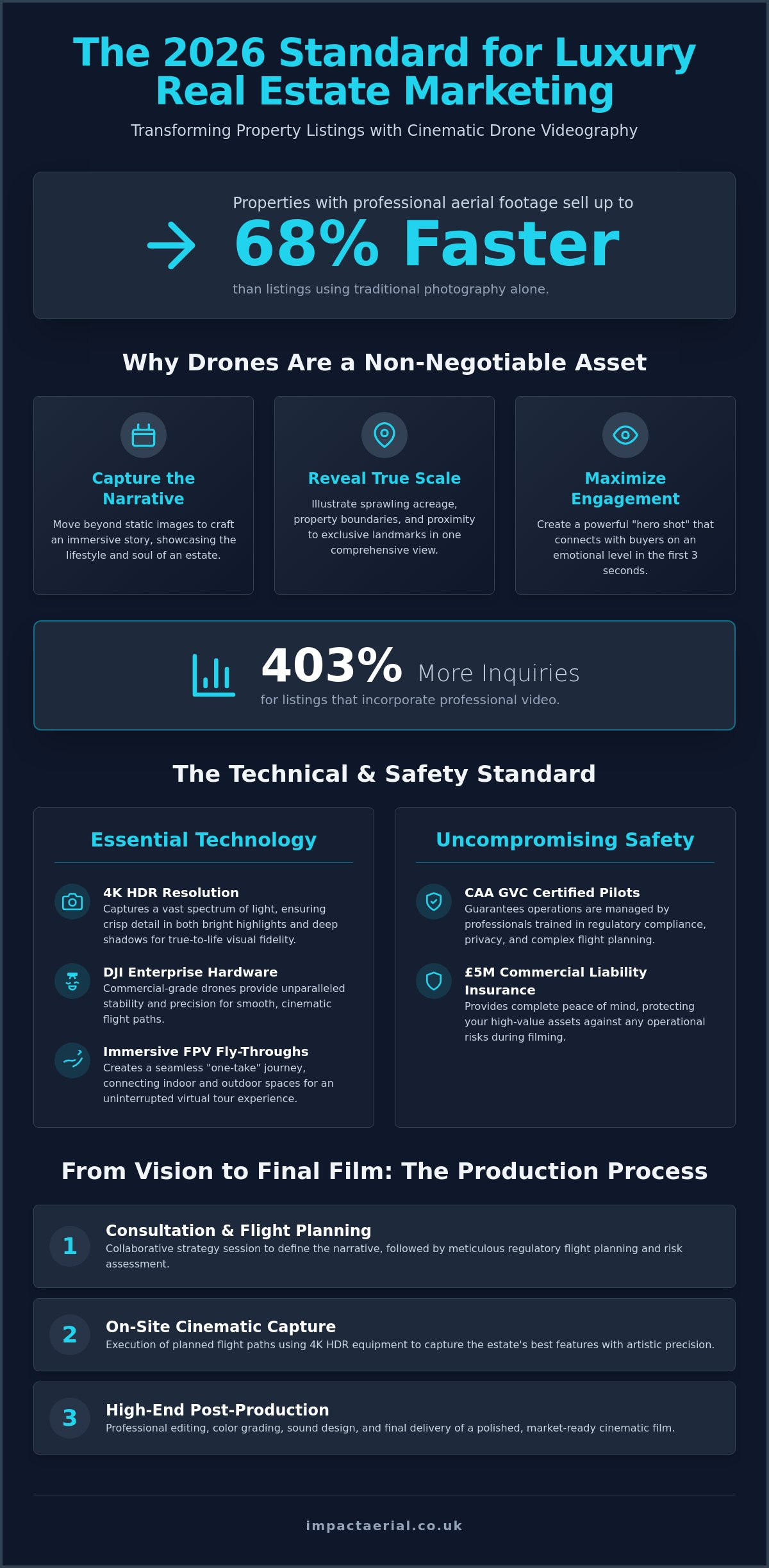
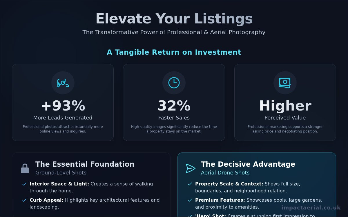
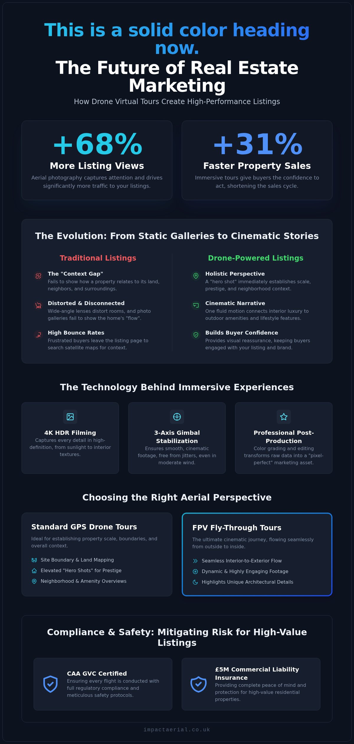
Did you know that listings featuring aerial photography receive 68% more views and sell 31% faster than those without? In the competitive 2026 market, standard image galleries often fail to convey the true scale and flow of a property. You’ve likely noticed that static photos just can’t capture the relationship between a luxury home and its surroundings, which frequently leads to high bounce rates from frustrated buyers who can’t get a feel for the layout.
We understand that professional drone virtual tours for real estate are no longer just a luxury; they’re a narrative tool that connects a property to its lifestyle in a single, cinematic flow. This article explores how these immersive experiences transform your listings into high-performance marketing assets that attract international interest and sell homes faster. We’ll examine the technical precision of 4K HDR filming, the rising demand for FPV fly-throughs, and the critical importance of CAA GVC certification to ensure every flight is conducted with meticulous safety and full regulatory compliance.
Key Takeaways
- Understand why standard 360 tours are no longer sufficient for 2026 buyers and how aerial perspectives bridge the gap between interior detail and neighbourhood context.
- Discover how drone virtual tours for real estate utilize 4K HDR filming and DJI Enterprise hardware to create immersive, high-definition experiences that capture every property detail.
- Learn to distinguish between standard GPS drone shots for site boundaries and FPV fly-throughs that provide a seamless cinematic journey from the garden to the living room.
- Identify the critical compliance requirements, such as CAA GVC certification and £5m commercial liability insurance, necessary to mitigate risk for high-value residential listings.
- Explore how professional post-production services transform raw aerial data into “pixel-perfect” marketing assets that build your reputation as a tech-forward agency.
The Evolution of Property Marketing: Why Standard 360 Tours Aren’t Enough
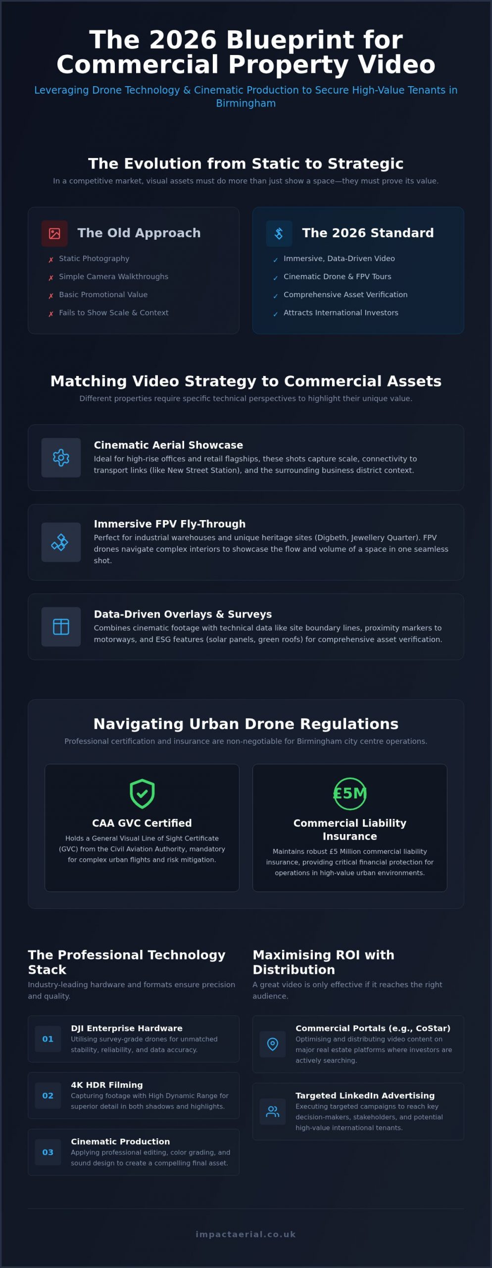
Property marketing has undergone a significant shift. By 2026, the expectations of high-end buyers have moved beyond simple photo galleries and basic walkthroughs. While Virtual tour technology has been a staple of the industry for years, traditional ground-based solutions often suffer from a “context gap.” They provide an excellent view of the kitchen or the master suite, but they fail to show how the property sits within its environment. This lack of perspective creates a disconnected experience, leaving potential buyers wondering about the proximity of neighbors, the true scale of the grounds, or the quality of the surrounding neighborhood.
Professional drone virtual tours for real estate bridge this gap by providing a holistic view that ground-based cameras simply cannot replicate. Data indicates that listings featuring aerial perspectives receive 68% more views and sell 31% faster on average. This isn’t just about a pretty picture; it’s about providing the technical data and visual reassurance that modern buyers require before they commit to a physical viewing. To better understand how this technology creates a seamless narrative, watch this example of an immersive aerial walkthrough:
The Problem with Static Listing Content
Static photos and standard 360 tours often feel clinical and disconnected. When a buyer clicks through a gallery, they struggle to visualize the “flow” of a home, especially in properties with complex layouts or expansive estates. This confusion leads to high bounce rates on listing pages. Ground-based wide-angle lenses can also distort rooms, creating an unrealistic expectation that leads to disappointment during in-person visits. Without an aerial perspective, the relationship between the front door, the garden, and local green spaces remains a mystery, forcing the buyer to do their own research on satellite maps rather than staying engaged with your listing.
Drones as the Ultimate Narrative Tool
Utilizing drone virtual tours for real estate transforms a listing from a simple viewing into a compelling story. By starting with a “hero shot” from an elevated perspective, you immediately establish the property’s scale and prestige. Drones allow us to connect the interior luxury of a home to its external environment in one fluid motion. We can show the transition from a sun-drenched patio to the local parkland or nearby amenities, providing the lifestyle context that 2026 buyers prioritize. This technical approach ensures that every pixel serves a purpose, building a brand reputation for your agency as a technologically adept leader that values precision and quality.
How Drone Technology Creates Immersive Real Estate Experiences
A drone virtual tour for real estate is a high-definition, interactive video or 360-degree experience captured via an Unmanned Aerial Vehicle (UAV). Unlike traditional video walkthroughs, these tours provide a continuous, interactive path that allows potential buyers to explore a property from perspectives that were previously impossible to achieve. The goal is to move beyond simple observation and create a sense of presence, where the viewer feels they are physically navigating the space and its surroundings.
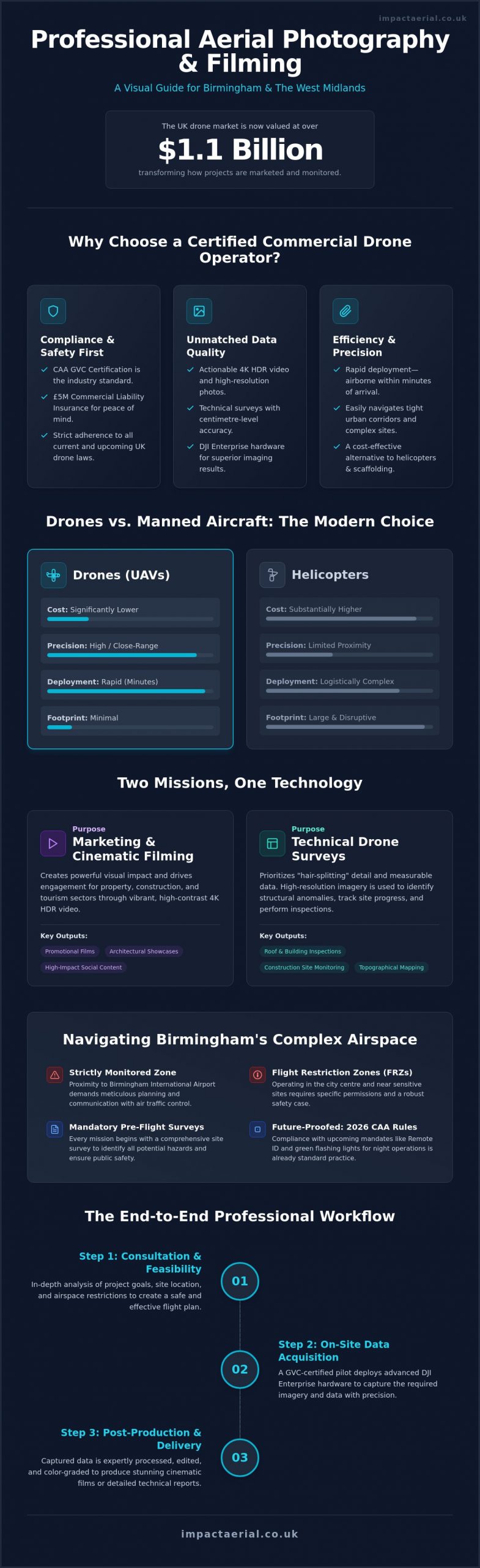
The technical foundation of these experiences relies on 3-axis gimbal stabilization and high-bitrate recording. This hardware ensures that even in moderate winds, the footage remains smooth and cinematic, devoid of the jitters or “jello effect” common in consumer-grade equipment. Once the flight is complete, the raw data enters a rigorous post-production phase. This is where professional editors stitch together panoramas, color-grade the footage for a “pixel-perfect” finish, and transform raw files into an interactive marketing asset that functions seamlessly across mobile and desktop platforms.
The Hardware: DJI Enterprise and 4K HDR
We utilize DJI Enterprise grade drones because they offer superior sensor sizes and reliability compared to standard retail models. These systems are equipped with 4K HDR cameras that excel at capturing dynamic range, which is critical during “golden hour” shoots where the sky is bright but the property remains in shadow. The use of 4K HDR technology allows for the precise rendering of property textures, ensuring that the natural grain of timber cladding or the intricate patterns of stonework are captured with absolute clarity. This technical precision provides the high-tier quality that luxury listings demand to maintain their market positioning.
Interactive Elements and Hotspots
Modern tours are no longer passive viewing experiences. By embedding clickable info-points or “hotspots,” agents can highlight specific selling points, such as premium appliance brands or smart home integrations, directly within the aerial view. We also integrate 360-degree panoramas at varying altitudes, giving buyers the ability to “look around” from 50 feet in the air. This interactive layer is often linked to broader virtual tour creation workflows, allowing a user to click on the roof to see a detailed survey or click the front door to enter an internal walkthrough. Utilizing professional aerial filming and photography ensures these transitions are seamless and technically sound, providing a reliable experience for out-of-area investors.
FPV vs. Standard Drone Tours: Choosing the Right Perspective
Selecting the appropriate flight methodology is a critical decision in the pre-flight planning phase. Not all properties require the same visual approach, and the choice between standard GPS-stabilised drones and First-Person View (FPV) systems depends entirely on the marketing objective. While one provides a steady, authoritative overview of the land, the other offers a high-speed, immersive journey that captures the “feeling” of living in the space. Integrating both perspectives into drone virtual tours for real estate ensures that you provide the technical data a buyer needs alongside the emotional narrative they want.
The “One-Shot” technique has emerged as the gold standard for luxury listings in 2026. This involves a single, continuous flight path that starts high above the property, descends toward the front door, and flies through the interior before exiting into the rear garden. It’s a seamless journey that eliminates the disjointed feeling of clicking through separate room photos. This method requires a pilot with exceptional spatial awareness and technical skill, as there’s no room for error when navigating through a multi-million-pound residence.
When to Use Standard Aerial Photography
Standard GPS drones are the industry workhorse for establishing geographical context. They are the superior choice when your primary goal is to showcase large land parcels, precise site boundaries, or the structural condition of a roof. This approach is particularly effective for commercial real estate and industrial sites across the West Midlands, where proving proximity to transport hubs like the M6 or Birmingham’s logistics corridors is a key selling point. Standard drones provide a rock-steady platform for high-resolution imagery. For a detailed look at how we capture these high-resolution stills, refer to our comprehensive guide on drone photography.
The Rise of the FPV “Indoor-Outdoor” Tour
FPV drones, specifically “cinewhoop” models, have revolutionised the way we market luxury urban apartments and modern estates. These micro-drones are equipped with shrouded propellers, allowing them to safely navigate through tight doorways and around high-end furniture without risk. They create a high-octane, modern feel that resonates with a younger, tech-forward demographic. Capturing a fluid transition from a sun-drenched balcony into a sleek kitchen requires professional FPV piloting skills that go far beyond standard flight certifications. In the UK, this level of precision is essential for maintaining safety standards while delivering a cinematic experience that keeps viewers on the page for longer. This technical mastery is what separates a basic recording from a professional marketing asset.
Compliance and Planning: What Real Estate Professionals Need to Know
Operational safety and legal compliance are the foundations of any professional aerial project. While the visual output of drone virtual tours for real estate is what sells the property, the regulatory framework behind the flight is what protects your agency’s reputation. Real estate professionals must treat drone operations as technical missions rather than casual photography sessions. This starts with ensuring that every pilot holds a current CAA GVC certification, which is the standard for professional competency in the UK.
This qualification is non-negotiable for commercial work. It signifies that the pilot has undergone rigorous training in flight safety, meteorology, and air law. Without this, any footage captured for a commercial listing is technically illegal, which can lead to significant fines for both the operator and the hiring agency. We treat every flight with the same meticulous attention to detail that we apply to our aerial filming and photography services, ensuring that risk is mitigated before the drone even leaves the ground.
Navigating UK Drone Laws in 2026
Flight restrictions vary significantly depending on the property’s location. Capturing a luxury apartment in Birmingham city centre requires a different level of planning than a rural estate in the West Midlands. Congested areas demand specific permissions and a higher degree of risk mitigation. We manage the entire process, from securing CAA permissions to drafting detailed Risk Assessment Method Statements (RAMS). A professional drone license acts as a badge of accountability, ensuring that all operations adhere to the latest safety standards.
Risk Mitigation and Reassurance
Privacy and data protection are paramount when flying in residential areas. We adhere to strict GDPR guidelines, ensuring that identifiable data like car registrations or neighboring windows are managed appropriately during post-production. Our pre-flight site assessments include several critical steps:
- Verifying airspace restrictions and local bylaws via official aviation charts.
- Notifying local authorities or neighbors when operating in sensitive areas.
- Establishing secure takeoff and landing zones to ensure public safety.
Relying on unlicensed hobbyists or “discount” operators puts your business at massive legal risk. If an accident occurs during a flight, an unlicensed pilot’s insurance is often void, leaving the estate agency liable for damages. Our £5m commercial liability insurance provides absolute reassurance and financial security for high-value properties and their owners. If you want to ensure your next marketing campaign is fully compliant and professionally executed, you can partner with Impact Aerial for your next property tour.
Partnering with Impact Aerial for Professional Virtual Property Tours
Selecting a provider for drone virtual tours for real estate requires more than just finding a pilot with a camera. It demands a technical partnership where the provider assumes all operational risk and regulatory responsibility. We position ourselves as technical consultants for your agency. This approach allows you to focus on the core business of selling properties while we deliver the high-tier visual assets required to attract serious, high-value buyers. Our commitment to precision ensures that every tour is not just a video, but a reliable data set that accurately represents the property.
We provide customized packages designed to meet the specific needs of both residential estate agents and commercial developers. Whether you’re marketing a single luxury residence or a multi-unit industrial complex, our team scales its operations to match the project’s scope. We handle the complexities of flight planning, safety protocols, and post-production, providing a seamless end-to-end service that integrates directly into your existing marketing workflows.
Our Process: From Brief to Broadcast
Every project begins with a creative planning session and a preliminary site survey. We don’t just show up and fly; we analyze the property’s orientation, lighting conditions, and potential flight hazards to ensure a safe and successful mission. During the execution phase, we utilize DJI Enterprise grade hardware to capture 4K HDR footage, ensuring the highest possible dynamic range and “pixel-perfect” detail. Our post-production team then takes over, meticulously editing the raw data to create a fluid, interactive experience. We understand that property launches are often time-sensitive, so we’ve optimized our internal processes to provide rapid turnaround times without sacrificing the quality of the final output.
Why Choose a Specialized UK Operator?
Our deep regional expertise in Birmingham and the West Midlands provides a distinct advantage for local property professionals. We understand the specific logistical challenges and airspace restrictions of the region, ensuring that every flight is conducted with total compliance. While our primary focus is the Midlands, we provide nationwide UK coverage, maintaining the same rigorous standards for every client. We’re committed to the highest drone services standards, ensuring that every project is backed by our CAA GVC certification and £5m commercial liability insurance. This level of professional accountability is essential for protecting your brand and your clients’ assets.
Ready to transform your property marketing with cinematic aerial experiences? You can request a consultation for your next real estate project to discuss your specific requirements and learn how our technical expertise can help you sell homes faster in 2026.
Securing a Competitive Advantage in 2026
The transition from static galleries to immersive, narrative-driven marketing is no longer optional for high-tier listings. By integrating drone virtual tours for real estate, agencies can bridge the context gap that traditional photography leaves behind, offering buyers a holistic view of both the property and its surrounding lifestyle. Whether you require the steady precision of standard GPS aerials or the high-octane flow of an FPV indoor fly-through, the technical execution must be flawless to maintain your brand’s reputation for quality.
Safety and compliance remain the most critical components of any aerial operation. Our team of CAA GVC Certified Pilots handles every aspect of flight planning and risk mitigation, backed by £5m commercial liability insurance. As a Birmingham-based specialist with UK-wide coverage, we provide the technical consultancy you need to launch properties with confidence and precision. We handle the technology so you can focus on closing the sale.
Don’t let your listings get lost in a sea of static photos. Book a Professional Drone Virtual Tour for Your Property Listing and give your clients the immersive cinematic experience they expect. We look forward to helping you transform your next property marketing campaign into a high-performance visual asset.
Frequently Asked Questions
Are drone virtual tours legal for residential properties in the UK?
Yes, drone virtual tours for real estate are entirely legal provided they are conducted by a pilot holding the correct Civil Aviation Authority (CAA) certifications. For commercial work in residential areas, a GVC (General Visual Line of Sight Certificate) is the professional standard. Pilots must also adhere to strict privacy laws and GDPR requirements to ensure that neighboring properties and uninvolved persons are not captured without appropriate justification or data management protocols.
How much do drone virtual tours for real estate typically cost?
The cost of a drone virtual tour depends on several technical factors rather than a single flat rate. Key variables include the size of the property, the complexity of the flight path, and the level of post-production required for a pixel-perfect finish. Urban locations in city centres like Birmingham may also require additional planning for airspace permissions, which influences the total project investment. We provide bespoke quotes based on your specific marketing objectives.
Can drones fly inside a house for a virtual tour?
Drones can safely fly indoors when using specialized FPV (First Person View) equipment. These “cinewhoop” drones feature shrouded propellers that prevent damage to interiors or high-end furniture. This technology allows for a seamless transition from the garden through the front door and into the living spaces. It creates an immersive, cinematic walkthrough that standard ground-based cameras cannot match, providing a continuous narrative of the home’s layout and flow.
How long does it take to shoot and edit a drone property tour?
A typical on-site shoot lasts between one and three hours depending on the property’s scale and the complexity of the flight plan. The post-production phase is more intensive, as raw 4K HDR data must be color-graded and edited into a fluid marketing asset. Most professional tours are delivered within three to five business days. This timeline ensures that every transition is smooth and the final output meets industry leadership standards for quality.
Do I need to notify the neighbours before a drone shoot?
While not a strict legal requirement for all flight categories, notifying neighbours is a highly recommended best practice for risk mitigation. Transparency helps manage privacy concerns and ensures the operation proceeds without interruption. As part of our pre-flight site assessment, we advise on the best way to communicate with local residents. This professional approach maintains the reputation of your agency and provides reassurance to the property owner that the shoot is compliant.
What happens if the weather is bad on the day of the drone flight?
Safety is our absolute priority, so flights are rescheduled if weather conditions fall outside of safe operational limits. High winds, heavy rain, or low visibility can compromise the aircraft’s stability and the quality of the 4K HDR footage. We monitor meteorological data meticulously in the days leading up to a shoot. If conditions are unsuitable, we coordinate with the agent to find the next available window with clear skies and optimal lighting.
What qualifications should a drone pilot have for real estate work?
A professional drone pilot must hold a CAA GVC certification to operate legally for commercial real estate projects in the UK. This qualification ensures the pilot understands air law, safety protocols, and technical flight requirements. Additionally, they should carry a minimum of £5m commercial liability insurance. These credentials provide the necessary legal protection and technical reassurance that your high-value property listings are in expert, compliant hands.
Are drone tours compatible with Rightmove and Zoopla?
Drone virtual tours for real estate are fully compatible with major UK portals like Rightmove and Zoopla. These platforms allow you to embed video content or link directly to interactive virtual tour experiences within the listing. Including an aerial tour can significantly increase time-on-page and engagement levels. This compatibility ensures that your tech-forward marketing reaches the widest possible audience, including international investors and out-of-area buyers who rely on immersive digital content.