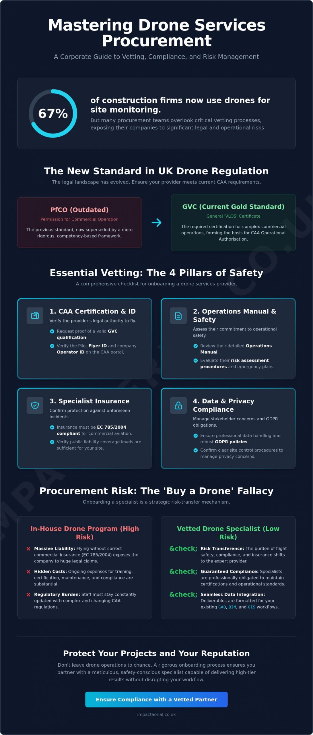
Did you know that 67% of construction firms now use drones for site monitoring, yet many procurement teams still treat these high-tech aerial assets like standard sub-contractors? When you’re onboarding a drone services company, the difference between a successful deployment and a legal nightmare often comes down to the quality of your vetting process. It’s common to feel uncertain about whether aerial data truly outperforms traditional methods, or to worry about the operational risks of having a drone over a live site.
We agree that the stakes are high. One oversight regarding CAA regulations or insurance can lead to significant liability. This guide is designed to help you master the corporate procurement process for drone services, ensuring full compliance and robust risk management. You’ll learn how to verify certifications, confirm specific insurance coverage, and ensure seamless data integration. We’ll provide a comprehensive checklist for vendor vetting, giving you the assurance that your provider is a meticulous, safety-conscious specialist capable of delivering high-tier results without disrupting your daily workflow.
Key Takeaways
- Understand the critical shift from PfCO to the GVC framework to ensure your drone provider meets current CAA regulatory standards for commercial operations.
- Master the strategic steps for onboarding a drone services company, focusing on rigorous legal vetting and operational alignment for complex corporate projects.
- Learn to define high-value deliverables through a clear Statement of Work that supports seamless data integration with existing CAD, BIM, and GIS workflows.
- Identify the essential insurance requirements, such as EC 785/2004 compliance, that protect your organization from liability and unforeseen site disruptions.
- Discover how to proactively manage stakeholder concerns regarding GDPR and privacy through robust site control procedures and professional data handling.
What is Professional Onboarding for Drone Services?
The formal process of onboarding a drone services company is a rigorous procurement procedure that moves beyond simply hiring a pilot. It represents a structured alignment of vetting, legal verification, and operational integration. For Tier 1 contractors and ISO-compliant organisations, this process is essential for maintaining safety standards and mitigating corporate liability. It marks the definitive shift from hiring amateur photography enthusiasts to partnering with technical consultants focused on high-precision commercial data collection. This professional approach ensures that aerial technology serves as a reliable tool for business intelligence rather than a source of operational risk.
To better understand this concept, watch this helpful video:
The industry has undergone significant regulatory changes, specifically the transition from the old Permission for Commercial Operation (PfCO) to the current CAA GVC framework. This evolution reflects a more structured approach to Global drone regulations, prioritising competency and risk assessment over simple flight hours. In a market where 67% of construction firms now use drones for site monitoring, professional onboarding ensures that your data is accurate, legally obtained, and ready for integration into business workflows. This meticulous vetting process provides the psychological comfort and tangible benefits required by modern project managers.
The Legal Framework: CAA GVC and A2 CofC
A CAA GVC certified pilot is the gold standard for complex commercial work. While the A2 Certificate of Competency (A2 CofC) allows for flights in less restrictive environments, it often lacks the robust safety frameworks required for industrial or construction site monitoring. The GVC provides the necessary foundation for obtaining an Operational Authorisation, which is the specific legal “permission to fly” granted by the CAA to commercial entities for complex missions. This certification ensures the operator has undergone rigorous theoretical and practical assessments tailored to professional environments where precision is non-negotiable.
Why “Just Buying a Drone” is a Procurement Risk
It’s tempting for businesses to purchase hardware internally, but this often creates significant procurement risks. While the cost of professional drones has decreased, the expense of training, maintaining compliance, and securing commercial-grade insurance remains high. Internal staff flying without specific commercial liability insurance (EC 785/2004 compliant) exposes the company to massive legal liability if an incident occurs. Onboarding a drone services company acts as a strategic risk-transfer mechanism. By partnering with a specialist, you shift the burden of regulatory compliance, equipment maintenance, and flight safety to an expert who is fully insured and certified to operate in high-risk zones, ultimately protecting your organization’s reputation and bottom line.
Essential Compliance Vetting: The 4 Pillars of Safety
When you are onboarding a drone services company, your first priority is a rigorous vetting of their legal credentials. This isn’t just about ticking boxes; it’s about verifying that the operator has the technical competency and legal authority to fly in complex environments. Start by requesting the pilot’s Flyer ID and the company’s Operator ID. You can verify these details directly through the Civil Aviation Authority (CAA) portal. As of 2026, an Operator ID is mandatory for any drone with a camera weighing 100g or more. This verification ensures that the provider is registered and accountable under current UK law, providing the first layer of protection for your project.
The second pillar involves reviewing the provider’s Operations Manual and safety record. A professional operator will have a detailed manual that outlines their specific safety protocols, risk assessment procedures, and emergency contingency plans. This document is a requirement for obtaining an Operational Authorisation from the CAA. Don’t hesitate to ask for evidence of past safety performance or site-specific risk assessments. A company that is transparent about its safety culture is far more likely to integrate into your on-site operations without causing disruption. This level of meticulousness is what separates a technical consultant from a casual operator.
Commercial Drone Insurance: Why £5m Liability Matters
While the minimum insurance requirement for commercial drone operations in the UK is governed by Regulation (EC) 785/2004, most Tier 1 contractors and property managers require a higher standard. A £5m public liability policy has become the industry benchmark for construction and commercial property sites. This coverage is vital because it protects your organization against claims related to property damage, personal injury, and accidental privacy breaches. If you’re commissioning technical data, ensure the provider also carries professional indemnity insurance. This protects you if a decision made based on their survey data leads to financial loss. Verifying these professional insurance standards is a non-negotiable step in the procurement process for any high-value asset manager.
Hardware Standards: 4K HDR and Thermal Capabilities
The choice of equipment is a key indicator of a provider’s professionalism. Consumer-grade drones often lack the sensor quality and stability required for high-stakes commercial drone surveys. Professional operators typically utilize DJI Enterprise models or equivalent commercial hardware. These systems offer 4K HDR video for marketing purposes and high-resolution sensors that capture the level of detail needed for technical inspections. For specialized projects like PV solar farm surveys or roof inspections, thermal imaging capabilities are essential. High-end thermal sensors can detect heat signatures and anomalies that are invisible to the naked eye, providing actionable intelligence that traditional methods simply cannot match. Confirming that your partner uses hardware with UK class marks (UK0 to UK6) also ensures they are compliant with the latest 2026 hardware regulations.
Operational Integration: Aligning Drone Data with Project Goals
Successful onboarding a drone services company requires a clear transition from compliance verification to operational execution. This stage is defined by the creation of a robust Statement of Work (SoW), which acts as the technical blueprint for the entire engagement. A well-structured SoW must explicitly define the nature of the deliverables, distinguishing between RAW data for technical analysis and polished, edited assets for stakeholder presentations. Establishing these parameters early prevents scope creep and ensures that the aerial intelligence gathered aligns perfectly with your specific business objectives, whether you’re monitoring a multi-year construction project or conducting a one-off structural survey.
Effective integration also depends on setting clear communication protocols for site-specific flight windows. Professional operators work around your schedule to minimize site disruption, often coordinating with site managers to identify periods of low activity. For long-term projects, such as weekly construction site monitoring, a consistent data collection frequency is established to create a reliable chronological record of progress. This methodical approach allows project managers to overlay aerial data directly into existing CAD, BIM, or GIS software, transforming visual assets into measurable technical insights that drive informed decision-making.
From Raw Footage to Actionable Intelligence
The value of professional drone services lies in the post-production process. While a standard pilot might provide basic files, a technical specialist transforms raw data into actionable intelligence. For marketing and corporate communications, aerial filming and photography involves sophisticated color grading and editing to produce cinematic-quality video. In more technical sectors, 3D photogrammetry and point clouds are generated to create high-precision digital twins of land or structures. These models are essential for land surveying and volume calculations. Additionally, virtual tour creation provides property professionals and advertising agencies with immersive, 360-degree perspectives that traditional photography cannot replicate.
Site Access and Pre-Flight Planning
A meticulous operator handles all the logistical complexities of site access long before the drone leaves the ground. This includes conducting a Site-Specific Risk Assessment (SSRA) to identify hazards like overhead power lines or public footpaths. Gaining landowner permission and notifying local authorities are standard procedures for a compliant provider. In restricted airspace, the operator will manage the “Notice to Airmen” (NOTAM) process, ensuring that other airspace users are aware of the drone activity. This level of pre-flight planning ensures that operations are conducted safely and legally, providing you with the reassurance that your project is in expert hands.
Risk Management and Privacy: Addressing Stakeholder Concerns
Effective risk management is the cornerstone of professional aerial operations. When you are onboarding a drone services company, you must look beyond the flight itself and evaluate how the provider manages the psychological and physical concerns of your stakeholders. Addressing the fear of “drone crashes” is a primary step in this process. Professional operators utilize hardware with significant technical redundancy, including dual batteries, multiple IMUs, and sophisticated obstacle avoidance sensors. These systems, combined with the pilot’s advanced flight skills, ensure that the risk of equipment failure is minimized. This technical approach provides the reliability that corporate clients expect when operating in high-value or sensitive environments.
Weather-related delays are an inherent part of aviation, but they shouldn’t compromise your project timelines. A specialist operator monitors meteorological data days in advance and maintains flexible scheduling to capitalize on safe flight windows. By establishing clear communication protocols during the onboarding phase, you can ensure that any weather-related adjustments are handled without impacting ground-level operations. This proactive management allows for a seamless integration of drone technology into your existing project schedule, maintaining momentum while prioritizing safety above all else.
GDPR and Data Privacy in Aerial Photography
Privacy is a significant concern for urban projects where drones may inadvertently capture images of the public. A professional pilot understands their legal responsibility to protect individual privacy by blurring faces and vehicle number plates in any non-consensual footage. For large-scale urban developments, conducting a Data Protection Impact Assessment (DPIA) is a critical step in the onboarding process. This assessment identifies potential privacy risks and outlines the mitigation strategies used to protect data subjects. Our team ensures that all captured data is stored on encrypted, secure servers with strict access controls to maintain the highest standards of digital security.
Mitigating Operational Disruption
One of the most significant benefits of aerial technology is its “non-contact” nature. Unlike traditional methods that require scaffolding, cranes, or cherry pickers, drones can inspect assets from a safe distance without touching the structure. This eliminates the need for expensive and disruptive physical access equipment. The efficiency of rapid deployment is clear when completing a drone roof survey, which can often be finished in hours rather than days. This speed significantly reduces the time spent on-site, allowing your team to continue their work without interruption.
To ensure zero impact on your daily operations, professional operators coordinate closely with site managers to establish robust “cordon and control” procedures. These involve securing take-off and landing zones and ensuring that flight paths avoid active work areas where possible. This meticulous planning ensures that the drone remains an unobtrusive tool for data collection. If you are ready to enhance your site safety and data accuracy, contact Impact Aerial today to discuss your specific project requirements.
Partnering with Impact Aerial: Your UK Onboarding Solution
Impact Aerial provides a comprehensive solution for corporate clients looking to integrate aerial intelligence into their operations. Our Birmingham based team delivers nationwide coverage, ensuring that high tier filming and surveying services are accessible across the UK. When you are onboarding a drone services company, the complexity of managing multiple vendors can be overwhelming. We simplify this by providing full project management, guiding you from the initial technical consultation through to the final post production delivery. Our commitment to CAA GVC certified excellence ensures that every flight is conducted with the highest regard for safety and regulatory compliance.
For Tier 1 contractors and large scale property developers, our £5m commercial liability insurance provides the necessary psychological comfort and legal protection required for high stakes projects. This level of coverage, combined with our meticulous adherence to safety protocols, makes us a trusted specialist for organisations that value external validation and industry standards. We don’t just fly drones; we provide a risk mitigated service that delivers tangible business benefits. By choosing a partner with established credentials, you ensure that your aerial data collection is both legally sound and technically superior.
Our Technology Stack: DJI Enterprise and 4K HDR
We utilise a commercial grade technology stack centred around DJI Enterprise hardware. These systems provide the superior stability and image quality needed for 4K HDR cinematic filming and high resolution technical inspections. Our specialised thermal surveying capabilities are particularly valuable for PV solar farm assessments and commercial property surveys, where detecting heat anomalies is critical for asset maintenance. Beyond data collection, our in house post production suite allows us to create immersive virtual tours and high end marketing films that showcase your projects from unique and aspirational perspectives. This end to end capability ensures that the data we capture is transformed into actionable intelligence for your stakeholders.
Streamlined Procurement for Corporate Clients
We understand that procurement departments need efficiency and clarity. To speed up your vendor onboarding process, we provide all essential compliance documentation, including our Operations Manual, insurance certificates, and pilot credentials, upfront. This transparency reduces the administrative burden on your team and ensures a faster path to project commencement. Our extensive experience working across the property, construction, and advertising sectors allows us to align our services with your specific industry requirements and safety standards. Contact Impact Aerial today to discuss your project requirements and discover how our professional drone services can transform your data collection workflow.
Securing Your Project’s Aerial Future
Mastering the process of onboarding a drone services company transforms a complex regulatory challenge into a streamlined operational advantage. By prioritizing CAA GVC certification and verifying robust insurance standards, you protect your organization from liability while gaining access to high-precision data. We’ve explored how aligning technical deliverables with your existing CAD or BIM workflows ensures that aerial intelligence becomes a functional part of your project management strategy. This structured approach moves your procurement beyond simple photography and into the realm of professional technical consultancy.
Impact Aerial is ready to support your next mission with our team of CAA GVC Certified Pilots and £5m commercial liability insurance. Based in Birmingham, we provide comprehensive UK-wide coverage for filming and surveying projects of any scale. We handle the entire project lifecycle, from initial risk assessments to final post-production, so you can focus on your core business goals. Request a professional drone services quote from Impact Aerial to begin your next project with confidence. We look forward to helping you achieve a new perspective on your operations.
Frequently Asked Questions
What certifications should I look for when onboarding a drone company?
You should prioritize the General Visual Line of Sight Certificate (GVC) and a valid Operational Authorisation from the CAA. These credentials confirm the pilot has undergone rigorous training and has the legal permission to conduct complex commercial flights. Additionally, verify their Operator ID and Flyer ID through the CAA portal to ensure they are registered under the latest 2026 UK drone regulations.
How much public liability insurance does a professional drone pilot need?
While the legal minimum is set by Regulation (EC) 785/2004, most corporate clients and Tier 1 contractors require a minimum of £5 million in public liability insurance. This level of coverage protects against property damage, personal injury, and privacy breaches on industrial or construction sites. Always confirm that the policy is specifically tailored for commercial drone operations rather than general business activities.
Can a drone company fly in restricted airspace like London or near airports?
Yes, professional operators can fly in restricted zones by obtaining specific permissions from National Air Traffic Services (NATS) or local Air Traffic Control (ATC). This process involves submitting a flight plan and coordinating closely with authorities to ensure safety. When onboarding a drone services company for projects in cities like London, ensure they have experience managing these complex coordination procedures.
Do I need to notify the police before a drone flight on my property?
You typically don’t need to notify the police for standard commercial drone operations on private property. The primary requirement is obtaining permission from the landowner and ensuring the flight complies with CAA safety distances. However, for high profile locations or large public events, a professional operator might inform local authorities as a courtesy to prevent unnecessary security concerns.
What is the difference between a PfCO and a GVC for commercial drones?
The PfCO (Permission for Commercial Operation) is a legacy qualification that has been phased out in favor of the GVC (General Visual Line of Sight Certificate). The GVC is the current professional standard required to apply for an Operational Authorisation from the CAA. It reflects updated safety protocols and hardware classifications that came into effect to align with modern aviation standards.
How long does the onboarding process typically take for a new drone vendor?
The process of onboarding a drone services company usually takes between three to ten working days depending on the depth of your internal compliance checks. This timeframe allows for the verification of insurance, CAA certifications, and the review of the operator’s safety manual. Providing clear procurement requirements early can significantly speed up this transition and move your project into the operational phase faster.
What data formats will I receive after a drone survey or filming session?
You will receive industry standard formats tailored to your specific software requirements. For aerial filming, this typically includes 4K MOV or MP4 files and high resolution JPG or RAW images. For technical surveys, data is delivered in formats like GeoTIFF for maps, LAS or OBJ for 3D point clouds, and PDF for detailed inspection reports that integrate into CAD or BIM software.
Is a drone survey really cheaper than traditional scaffolding?
Yes, drone surveys are significantly more cost effective, often reducing inspection expenses by over 50% compared to traditional scaffolding or cherry pickers. Aerial inspections eliminate the high costs of equipment rental, labor for assembly, and site downtime. A drone can complete a comprehensive roof survey in hours rather than days, providing high resolution data without the physical risks of working at height.
