Drone Videography Services Birmingham: The Professional Guide to Aerial Film in 2026

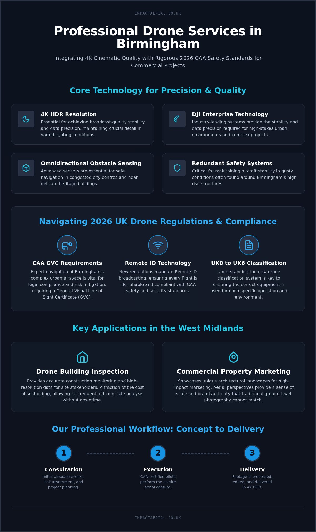
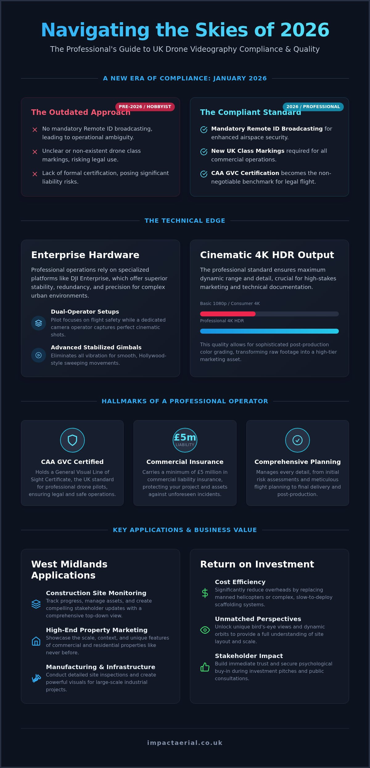
In 2026, the difference between a high-end commercial production and a significant legal liability often comes down to a single UK class mark. You likely recognize that aerial visuals are no longer just a luxury; they’re a requirement for staying competitive in the West Midlands market. However, with the January 2026 implementation of mandatory Remote ID broadcasting and new UK class markings, the technical barrier to entry has never been higher. It’s natural to feel overwhelmed by the choice between FPV agility and standard cinematic stability, or to worry about the complexities of CAA GVC certification and insurance requirements.

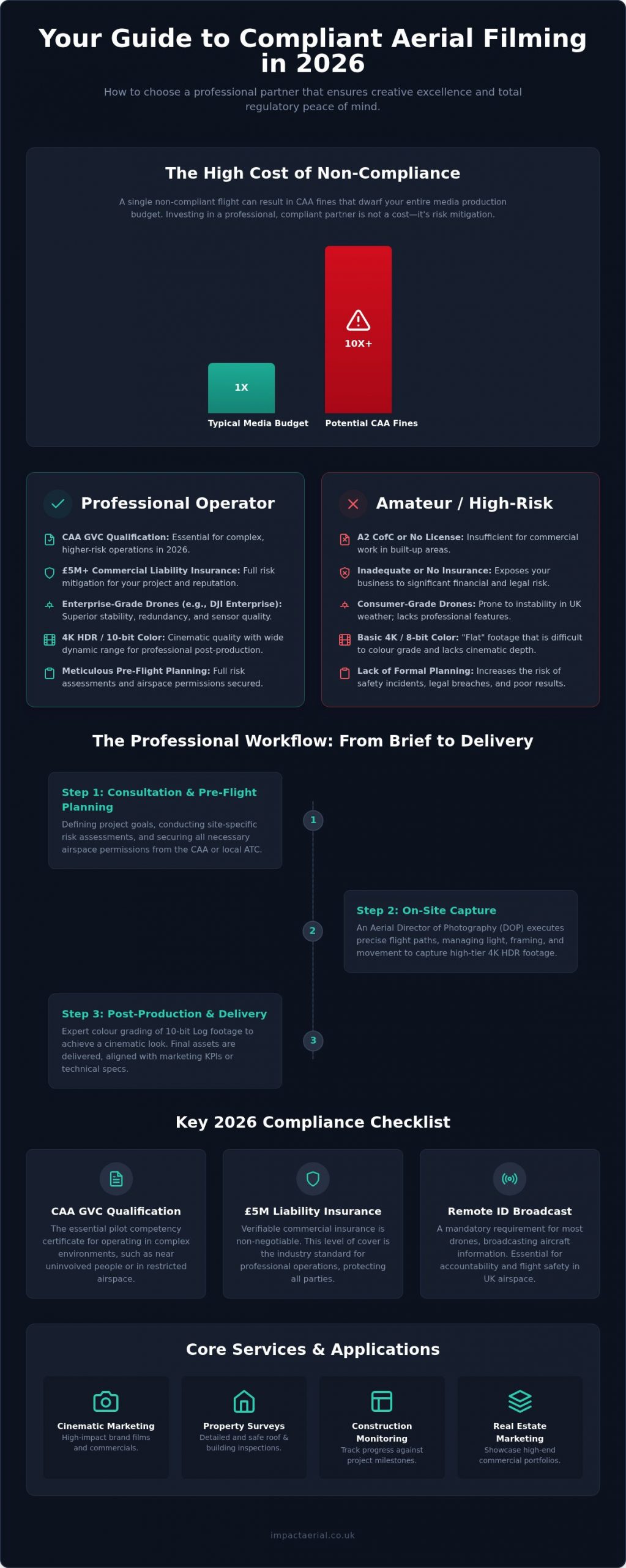
This guide demonstrates how Impact Aerial’s professional drone videography services in Birmingham can bridge the gap between creative ambition and operational safety. You’ll learn how a meticulous approach to flight planning and 4K HDR capture delivers a tangible return on investment for your commercial projects. We’ll preview the essential hardware standards for 2026, the importance of £5m commercial liability insurance, and how certified pilots manage every regulatory hurdle from initial risk assessment to final post-production. By the end, you’ll understand how to secure cinematic content that is both visually stunning and fully compliant with current UK aviation law.

Key Takeaways

  • Discover how professional drone videography services Birmingham combine cinematic 4K HDR filming with strict 2026 UK aviation compliance to elevate commercial projects.
  • Understand the critical regulatory shifts in 2026, including mandatory Remote ID broadcasting and why CAA GVC certification is essential for legal commercial operations.
  • Learn to leverage aerial data for construction site monitoring and high-end property marketing to effectively track progress and showcase scale across the West Midlands.
  • Explore the technical advantages of advanced professional drone hardware and how professional post-production transforms raw aerial footage into high-tier marketing assets.
  • Identify the hallmarks of a reliable operator, including £5m commercial liability insurance and comprehensive project management from initial consultation to delivery.

Defining Professional Drone Videography Services in 2026

Professional drone videography is no longer just about taking pictures from the sky. It’s a highly specialized discipline within the operation of an Unmanned Aerial Vehicle (UAV) that requires technical mastery and strict adherence to CAA protocols. In 2026, the industry has reached a turning point. Businesses in the West Midlands are moving away from simple ‘aerial footage’ toward ‘integrated visual data’. This shift means every frame serves a dual purpose: high-impact marketing and precise technical documentation.

To see how these principles translate into cinematic results, watch this example of professional work in the region:

The gap between a consumer recording and professional drone videography services Birmingham is defined by hardware and pilot skill. While hobbyist drones might capture decent images in perfect light, professional-grade 4K HDR output ensures maximum dynamic range and detail retention. This level of precision allows for sophisticated color grading in post-production. It ensures that commercial property developments or infrastructure projects are presented with the clarity required for high-stakes stakeholder engagement. Leading industries in Birmingham, particularly construction, commercial real estate, and large-scale manufacturing, now rely on these visuals to drive their procurement and marketing strategies.

The Evolution of Aerial Film Standards

The industry has moved far beyond basic 1080p resolution. Today, cinematic 4K HDR is the baseline for professional delivery, providing the depth needed for large-scale displays and digital advertising. Advanced stabilized gimbals are essential; they eliminate vibration and allow for ‘Hollywood-style’ sweeping movements that once required expensive cranes. We define drone videography as a versatile tool for both high-end marketing and rigorous technical documentation. This evolution allows for a level of detail that supports everything from architectural visualization to detailed site inspections.

Why Birmingham Businesses Choose Aerial Perspectives

UAVs unlock perspectives that are physically impossible for ground-based crews or traditional scaffolding. Birmingham’s rapid urban expansion and the development of the West Midlands industrial sector demand a view that captures both scale and context. Choosing an aerial perspective provides several advantages:

  • Cost Efficiency: Replacing manned helicopters or complex scaffolding systems significantly reduces project overheads and setup times.
  • Unique Angles: Capturing bird’s-eye views and low-altitude orbits provides a comprehensive understanding of site layout and spatial relationships.
  • Stakeholder Impact: High-production-value visuals build immediate trust and psychological buy-in during investment pitches or public consultations.

By integrating these perspectives, companies can demonstrate progress and value with a clarity that ground-level photography cannot match.

The Technical Edge: Commercial Hardware and Pilot Expertise

High-tier drone videography services Birmingham rely on hardware that far exceeds consumer capabilities. We utilize DJI Enterprise platforms because they offer the stability and redundancy required for operating in complex urban environments like Birmingham city centre. These systems aren’t just drones; they’re aerial workstations designed for precision. For complex cinematic sequences, we often deploy dual-operator setups. This allows one specialist to focus entirely on flight safety and navigation while the second operator manages the camera gimbal. This division of labor is essential for capturing perfectly framed 4K HDR footage while moving through tight architectural spaces.

Enterprise Drones vs. Consumer Models

The distinction between consumer drones and enterprise hardware lies in reliability and output quality. Commercial UAVs feature larger sensors and interchangeable lenses that are critical for professional color grading and detail retention in varying light conditions. While a hobbyist drone might struggle with digital noise in the shadows of high-rise developments, enterprise sensors maintain clarity across the entire dynamic range. This technical edge allows our team to deliver high-tier visuals that stand up to the scrutiny of large-scale marketing campaigns.

Reliability is equally important for maintaining project schedules. Enterprise models often include weather-resistance ratings, such as IP55, which protect against light rain and dust. This capability ensures that a shoot doesn’t have to be abandoned at the first sign of typical West Midlands drizzle. These drones also feature redundant batteries and propulsion systems. This redundancy provides an extra layer of safety when flying near valuable infrastructure or in busy commercial districts.

The Skillset of a CAA GVC Certified Pilot

Technical hardware is only half of the equation; the pilot’s expertise is what transforms a flight into a cinematic asset. Every professional operation must strictly adhere to UK Civil Aviation Authority drone regulations to ensure public safety and legal compliance. Our pilots hold the General Visual Line of Sight Certificate (GVC), a qualification that demonstrates a deep understanding of air law, meteorology, and emergency procedures. This certification is the gold standard for commercial drone work in the UK.

However, a certified pilot must also be a creative director. This requires a unique blend of technical aviation knowledge and a cinematic vision for composition, lighting, and movement. For a deeper look at how these standards apply to your project, see our A Complete Guide to Professional Drone Services in the UK. When you choose a specialist who understands both the lens and the law, you’re investing in a final product that is as safe as it is visually striking. If you’re ready to discuss the technical requirements of your next shoot, contact our Birmingham team for a professional consultation.
Drone Videography Services Birmingham: The Professional Guide to Aerial Film in 2026

Key Applications for Drone Videography in Birmingham

Professional drone videography services Birmingham provide more than just aesthetic value; they offer essential operational insights across the region’s most active sectors. From the sprawling industrial hubs in the Black Country to the high-density redevelopment of Birmingham city centre, aerial film is used to solve complex logistical and marketing challenges. In 2026, the application of this technology has branched into four primary areas: commercial property marketing, construction site monitoring, corporate brand storytelling, and technical infrastructure inspections.

Real Estate and Property Development

In the competitive West Midlands property market, static images often fail to convey the true scale of a development. Aerial video provides a comprehensive view of a project’s footprint, its proximity to transport links like HS2, and its relationship with the surrounding urban landscape. This perspective is vital for securing planning permissions and maintaining stakeholder engagement throughout the build lifecycle. For projects requiring high-resolution stills alongside cinematic film, our Drone Photography: The Ultimate Guide to Aerial Imagery explains how to integrate these assets into a cohesive marketing strategy.

Construction and Infrastructure Surveys

The construction sector remains the largest adopter of UAV technology in Birmingham. Regular site monitoring through 4K video allows project managers to track progress against milestones with precision while creating a visual record that is far more detailed than ground-based reporting. It also serves as a robust tool for safety audits. By deploying drones for high-risk inspections, firms can remove personnel from dangerous environments such as fragile roofs or high-rise scaffolding. All such operations must strictly follow the UK Drone Regulations to ensure site safety and legal compliance.

For teams needing detailed technical analysis, our Drone Survey: The Complete Guide to Aerial Data Collection provides a deep dive into how video data is converted into actionable site reports. This methodical approach to data collection ensures that every flight contributes to the project’s overall safety and efficiency.

Advertising and Technical Inspections

Local businesses use aerial film to tell high-impact brand stories that resonate with a modern audience. Whether it’s showcasing a manufacturing facility or creating a promotional film for a city centre event, the cinematic quality of 2026 drone technology provides a level of production value previously reserved for big-budget agencies. Simultaneously, technical surveys use the same high-resolution video for roof inspections and infrastructure checks. This allows for the identification of defects without the need for costly plant hire, scaffolding, or road closures in busy metropolitan areas.

Compliance and Safety: UK Drone Regulations in 2026

The legal landscape for drone videography services Birmingham has evolved significantly since the January 2026 regulatory updates. Operating under the current Civil Aviation Authority (CAA) framework requires more than just a Flyer ID; it demands a comprehensive understanding of the Open and Specific categories of flight. While hobbyists can operate within strict limits for recreation, any flight conducted for commercial gain or project data falls under professional requirements. This distinction is critical for businesses. Hiring a hobbyist for a commercial project doesn’t just produce inferior results; it creates a substantial legal risk for the client if an incident occurs.

Safety is not an afterthought. It’s built into the “invisible” work of risk assessments and flight planning that occurs long before the drone leaves the ground. Professional operators spend hours analyzing site-specific hazards and coordinating with local authorities. £5m commercial liability insurance is the recognized industry standard for commercial site access in the West Midlands. Most main contractors and property managers will not grant site entry without proof of this specific level of cover. Commercial liability insurance is a prerequisite for commercial site entry.

Understanding the UK Drone License

In 2026, the General Visual Line of Sight Certificate (GVC) remains the essential qualification for pilots operating in the Specific category. This certification proves the pilot has undergone rigorous training in air law, meteorology, and emergency handling. Hiring an unlicensed operator exposes your business to potential fines and the immediate voiding of any existing site insurance. For a detailed breakdown of these requirements, read our UK Drone License: A Simple Guide to CAA Rules in 2026. Ensuring your pilot is current with these standards is the only way to guarantee a legally compliant shoot.

Risk Mitigation and Public Safety

Operating drone videography services Birmingham in the city centre presents unique challenges, from high-density crowds to complex wind tunnels created by high-rise architecture. Professional operators manage these risks by conducting pre-flight site surveys and checking NOTAMs (Notice to Airmen) for temporary airspace restrictions. This is particularly vital in Birmingham due to the proximity of the international airport and various restricted helipads. We utilize advanced telemetry to monitor the airspace in real-time, ensuring that every flight remains within legal and safe parameters. To ensure your project meets every legal and safety requirement, consult with our CAA-certified team in Birmingham today.

Planning Your Project with Impact Aerial

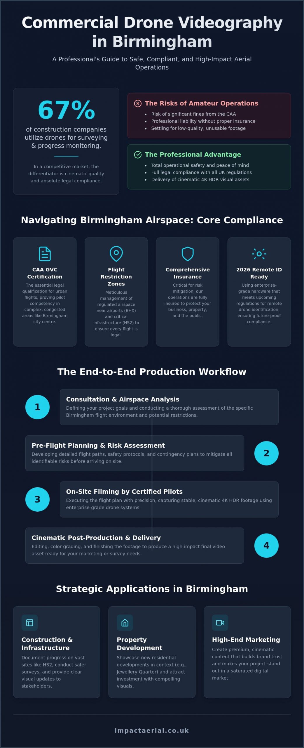
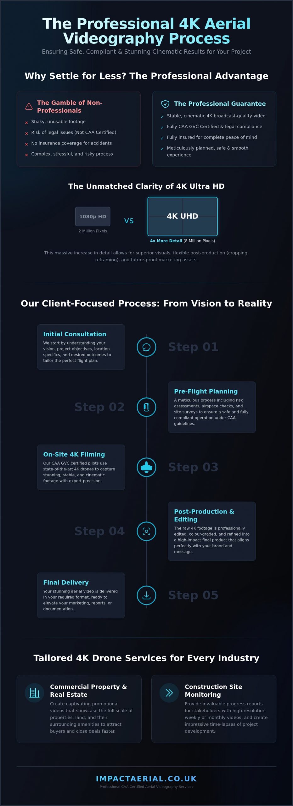
Integrating professional drone videography services Birmingham into your commercial workflow requires a structured, four-step methodology designed to mitigate risk while maximizing visual impact. We begin every project with a comprehensive initial consultation to define your specific cinematic vision and project objectives. This phase is critical for aligning our technical capabilities with your brand’s narrative goals. Following this, we conduct a rigorous feasibility study. We assess the target location for physical obstacles, restricted airspaces, and necessary CAA-compliant flight planning. Our team leverages deep local knowledge of the West Midlands to secure permissions and identify optimal launch sites that external operators might overlook.

On-site execution is handled by our CAA GVC certified pilots utilizing DJI Enterprise hardware. This equipment ensures maximum data security and flight stability in the challenging urban environments typical of the Birmingham city centre. Unlike a basic “camera only” hire, our team manages the entire operational environment, from ground-level safety cordons to the final 4K HDR capture. This professional oversight guarantees that your project remains on schedule and within all legal boundaries. While we are a Birmingham-based team, we maintain a nationwide reach, providing consistent high-tier quality across the UK.

The Post-Production Process

Raw aerial footage is simply the foundation of a professional film. Our post-production services transform raw 4K HDR files into brand-consistent stories through meticulous editing and color grading. We use advanced grading techniques to ensure that the visual tone aligns perfectly with your corporate identity. Sound design and professional pacing are then applied to create a high-impact narrative that holds stakeholder attention. For a deeper understanding of these cinematic techniques, see our guide on Aerial Filming Drone: The Ultimate Guide to Professional Cinematic Video.

Requesting a Professional Quote

Every aerial project in the West Midlands presents unique variables that influence the final scope of work. Factors such as the complexity of the location in high-density urban areas, total flight duration, and the specific sensors required for the shoot will determine the project requirements. Choosing full project management provides a significant return on investment compared to hiring an uncertified hobbyist. You gain the psychological comfort of £5m commercial liability insurance and the assurance that all content is legally compliant for commercial use. To begin your project with a team that understands the intersection of the lens and the law, contact Impact Aerial for a professional drone videography consultation and receive a tailored proposal for your specific needs.

Elevating Your Commercial Vision in the West Midlands

Professional aerial film in 2026 is defined by a rigorous commitment to safety and technical precision. As we’ve explored, the transition to integrated visual data requires more than just a camera in the sky; it demands a deep understanding of current CAA frameworks and the creative expertise to deliver cinematic 4K HDR content. By choosing specialized drone videography services Birmingham, you ensure your project benefits from a local team that understands both the regional landscape and the complexities of modern aviation law.

Impact Aerial provides the reassurance of CAA GVC Certified Pilots and £5m Commercial Liability Insurance, ensuring every flight is legally compliant and fully protected. Our end-to-end service includes full post-production editing to transform raw footage into a brand-consistent narrative that drives stakeholder engagement. Whether you’re monitoring a major construction site or marketing a high-rise development, the right aerial perspective offers a tangible return on investment that ground-based photography can’t replicate.

Ready to transform your next project with high-tier aerial visuals? Request a Professional Drone Videography Quote today and let us help you capture the scale and detail your business deserves. We look forward to bringing your vision to life safely and professionally.

Frequently Asked Questions

Is drone videography legal in the UK?

Drone videography is legal in the UK when conducted by certified operators who adhere to the Civil Aviation Authority (CAA) framework. For commercial drone videography services Birmingham, pilots must hold a valid Flyer ID and Operator ID. Operations in the Specific category require a General Visual Line of Sight Certificate (GVC). This ensures the pilot has undergone rigorous training in air law and safety protocols to operate legally and safely in public spaces.

What insurance does a professional drone pilot need for commercial work?

Professional pilots must maintain insurance that is compliant with EC 785/2004 regulations for commercial operations. We carry £5m commercial liability insurance as standard; this is often a prerequisite for accessing construction sites and managed commercial properties in the West Midlands. This level of cover provides essential protection for both the operator and the client. It covers potential third-party property damage or injury, ensuring all stakeholders are fully protected during the project.

Can you fly drones in Birmingham city centre or near the airport?

Flying in Birmingham city centre or within the Flight Restriction Zone (FRZ) of Birmingham Airport is possible but requires advanced coordination. Professional operators must secure permissions from Air Traffic Control (ATC) and potentially the local police for specific urban areas. We handle all necessary applications and liaison with NATS to ensure every flight is authorized. This methodical approach allows us to capture high-impact visuals even in the most restricted metropolitan environments.

What is the difference between FPV and standard drone filming?

Standard drone filming uses GPS-stabilized platforms to produce smooth, cinematic shots ideal for property and corporate film. FPV (First Person View) videography involves the pilot wearing goggles to fly more agile, high-speed drones. This technique creates immersive, “one-take” style footage that can fly through tight gaps or follow fast-moving subjects. While standard filming focuses on stability, FPV offers a dynamic, high-energy perspective that is increasingly popular for promotional brand stories.

How much does professional drone videography cost in 2026?

The cost of professional drone services depends on the project’s specific requirements, such as location complexity, flight duration, and the level of post-production needed. Factors like the requirement for dual-operator setups in busy city centres also influence the scope. We provide tailored quotes following an initial consultation to ensure the pricing reflects the technical demands of your vision. This approach ensures you receive a high-tier product without paying for unnecessary extras.

What happens if the weather is poor on the day of the shoot?

Safety is our primary concern, and flights are subject to suitable meteorological conditions. If wind speeds exceed safe operational limits or if precipitation is heavy, we’ll reschedule the shoot to the next available window. Modern enterprise hardware can handle light drizzle, but we always prioritize the safety of the public and the quality of the final 4K HDR footage. This ensures that your project is never compromised by avoidable environmental risks.

Do I need to provide a risk assessment for the drone pilot?

You don’t need to provide a risk assessment, as this is a core responsibility of the certified drone pilot. As part of our professional drone videography services Birmingham, we conduct a comprehensive site-specific risk assessment (SSRA) before every flight. This document identifies potential hazards, such as overhead power lines or public footpaths, and outlines our mitigation strategies. This process is a mandatory requirement under our CAA operating safety case and ensures a secure environment.

What is the typical turnaround time for an edited drone video?

Turnaround times vary based on the complexity of the shoot and the depth of editing required. A standard promotional video typically involves 4K HDR capture followed by professional color grading and sound design in post-production. We aim to deliver initial drafts within a timeframe discussed during your consultation; this ensures the final narrative is brand-consistent and ready for distribution. This structured workflow allows us to maintain high-tier quality while meeting your project’s specific deadlines.
Professional Drone Services in the West Midlands: The 2026 Commercial Guide

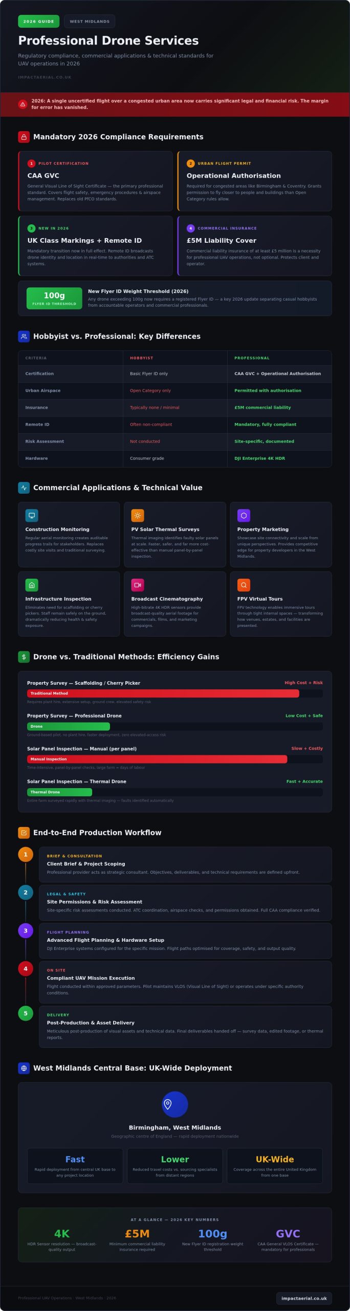
In 2026, the margin for error in aerial operations has vanished; a single uncertified flight over a congested Birmingham street now carries significant legal and financial risks that many project managers don’t fully realise. As the UK transition to mandatory UK class markings and Remote ID takes full effect, the distinction between a hobbyist with a camera and professional drone services West Midlands companies can legally hire has never been more critical. You likely recognise the immense value of high-resolution 4K HDR data for surveys or marketing, yet the fear of regulatory blowback or safety incidents often stalls ambitious projects.

We’re here to bridge that gap by providing a definitive roadmap for professional UAV operations this year. You’ll learn how to master the complex landscape of 2026 regulations, from the new 100g Flyer ID threshold to the necessity of £5m commercial liability insurance. This guide explores the technical applications that make drone technology a cost-effective alternative to traditional filming, ensuring your next project is both cinematically stunning and meticulously compliant.

Key Takeaways

  • Understand how professional drone services West Midlands providers navigate the complex urban airspace of Birmingham using end-to-end project management.
  • Identify mandatory 2026 safety standards, specifically the CAA GVC and the requirement for Operational Authorisation in congested urban hubs.
  • Explore high-value technical applications, including construction site monitoring, PV solar farm thermal surveys, and high-resolution virtual tour creation.
  • Learn how a structured production workflow manages site permissions and risk assessments to ensure full regulatory compliance on every flight.
  • Discover the logistical benefits of a central West Midlands base for rapid, cost-effective deployment across the United Kingdom.

The Scope of Professional Drone Services in the West Midlands

Professional drone services West Midlands teams provide have transitioned from simple aerial photography into comprehensive data management systems. In 2026, these operations manage the entire lifecycle of visual assets and technical data. A professional provider acts as a strategic consultant, handling the intricate legalities and safety protocols required for complex urban environments like Birmingham city centre. This partnership ensures every mission is compliant with the Civil Aviation Authority (CAA) while meeting specific commercial objectives. It isn’t just about flying; it’s about precision.

Modern aerial operations require a structured workflow that encompasses site-specific risk assessments and meticulous post-production. Whether you’re commissioning a technical survey or a high-end marketing film, the provider manages the “headache-free” logistics so your team can focus on core tasks. By integrating advanced flight planning with high-spec hardware, professional services deliver a level of precision that consumer equipment cannot match.

To see how these aerial systems support regional safety and infrastructure, watch this overview from the West Midlands Fire Service:

The Evolution of UAV Technology for Business

The industry has moved decisively toward DJI Enterprise platforms, which offer the reliability needed for high-stakes commercial work. High-bitrate 4K HDR sensors now provide the clarity required for broadcast-quality cinematography and detailed inspections. FPV (First Person View) technology is also changing how we create immersive commercial tours by allowing drones to move fluidly through tight internal spaces. These tools support a wide range of commercial applications of drones, providing both aesthetic and technical value without the limitations of older hardware.

Economic Benefits for West Midlands Industries

For regional industries, the financial benefits are clear. Using a drone for a property survey is far more efficient than traditional plant hire like scaffolding or cherry pickers. It keeps staff safely on the ground, significantly lowering health and safety risks during infrastructure checks. Construction firms use regular aerial monitoring to maintain an auditable trail of progress for stakeholders. Property developers also gain a competitive edge by showcasing the connectivity and scale of their West Midlands sites from unique perspectives that ground-based assets cannot replicate.

Regulatory Compliance: The 2026 Standard for West Midlands Pilots

Operating a commercial UAV in 2026 requires a sophisticated understanding of the UK’s evolving aviation laws. For any business commissioning drone services West Midlands wide, the legal landscape has shifted towards stricter accountability and clear technical benchmarks. The primary standard for professional pilots is now the CAA GVC (General Visual Line of Sight Certificate). This qualification demonstrates a pilot’s competency in flight safety, emergency procedures, and airspace management, moving beyond the basic flyer IDs used by hobbyists.

Compliance isn’t just about the pilot’s skills; it’s about the specific permissions granted by the regulator. In congested urban environments like Birmingham or Coventry, standard flight rules often aren’t enough. Professional operators must hold an Operational Authorisation from the CAA to fly closer to people and buildings than the “Open Category” allows. This document is a critical safety barrier that ensures urban missions are conducted without endangering the public or local infrastructure.

Navigating CAA GVC and Operational Authorisation

The transition from the old PfCO standards to the current GVC requirements reflects a more rigorous approach to urban flight. Professional pilots manage complex permissions in restricted West Midlands airspace by coordinating with Air Traffic Control and monitoring local restrictions. If you’re unsure which category your project falls into, understanding the requirements for a valid drone license is the first step toward a legal and successful operation.

Risk Assessment and Safety Protocols

Every professional flight begins long before the propellers spin. A meticulous pre-flight process involves site surveys, weather monitoring, and checking NOTAMs (Notices to Air Missions) for temporary airspace restrictions. This technical preparation aligns with the latest Civil Aviation Authority drone guidance, ensuring that data privacy and public safety are never compromised. In high-traffic commercial environments, these protocols are the only way to mitigate risk effectively.

Risk mitigation also extends to financial protection. All commercial drone work in the UK legally requires third-party insurance that complies with EC 785/2004. We maintain £5m commercial liability insurance as a non-negotiable standard. This high level of coverage provides psychological comfort to our clients, ensuring they aren’t exposed to liability should an unforeseen incident occur. When you prioritise these regulatory benchmarks, you ensure your project stays on the right side of the law. If you need assistance verifying the compliance of your next site, our team can help you assess your specific regulatory needs.

Professional Drone Services in the West Midlands: The 2026 Commercial Guide

Commercial Applications: From Marketing to Technical Data

Professional drone services West Midlands teams provide now deliver a sophisticated dual-stream output: high-impact cinematic production and precision technical data. This integration is a cornerstone of the expanding commercial drone use in the UK, where aerial platforms act as both creative assets and critical survey instruments. By utilizing 4K HDR sensors, we capture “hero” shots for brand campaigns while simultaneously providing the high-bitrate footage required for detailed infrastructure assessments. This versatility allows businesses to extract maximum value from a single deployment.

Property and Real Estate Visuals

In the competitive West Midlands commercial market, capturing the scale and connectivity of an estate is vital. Aerial imagery highlights strategic transport links, such as proximity to major motorway networks or regional rail hubs, providing context that ground-based photography lacks. Implementing professional drone photography is a proven method for accelerating commercial enquiries; it allows prospective tenants and investors to grasp the full layout of a development instantly. Beyond static images, we create immersive virtual tours that facilitate remote stakeholder engagement, ensuring that project milestones are visible to decision-makers regardless of their location.

Drones in Construction and Infrastructure

Construction site monitoring has evolved into a mandatory requirement for modern project management. Regular aerial filming provides an auditable visual trail of progress, serving as both a PR tool and essential health and safety documentation. Instead of relying on manual inspections that require scaffolding or cherry pickers, drones allow for the safe assessment of roofs and complex structures. This data-centric approach integrates seamlessly into wider drone survey workflows, where 4K video assets are used to identify structural anomalies or thermal leaks in PV solar farms.

For infrastructure projects, time-lapse aerial filming offers long-term documentation that is invaluable for stakeholder reporting. By capturing consistent perspectives over several months, we provide a clear narrative of the project’s evolution. This level of technical oversight ensures that potential issues are identified early, reducing the risk of costly delays and enhancing the overall ROI of the construction phase. By choosing a partner who understands both the aesthetic and technical requirements, you ensure that your data is both accurate and persuasive.

The End-to-End Production Process: From Brief to Delivery

Hiring drone services West Midlands teams shouldn’t feel like a gamble. A professional operation functions as a technical consultancy, managing every variable from the initial brief to the final export. This process begins with a consultation to define your creative goals and technical requirements while assessing legal feasibility. We don’t just ask what you want to see; we determine what’s legally permissible under 2026 CAA regulations. This meticulous approach ensures that your project is built on a foundation of safety and compliance from day one.

Once feasibility is confirmed, the pre-production phase handles the logistical heavy lifting. This includes managing site permissions, conducting detailed risk assessments, and issuing local authority notifications. For projects in dense urban hubs like Birmingham, we coordinate with local councils and the police to ensure operations in public spaces, such as those near Birmingham New Street, don’t disrupt the community. This “headache-free” management is what separates a professional consultant from a basic operator.

Planning for Success in the West Midlands

Operating in the heart of the UK requires a sophisticated understanding of the local environment. We manage the “weather window” through constant monitoring and contingency planning, ensuring that your project stays on track despite the unpredictable UK climate. Every aerial filming drone deployment follows a site-specific safety brief. This isn’t just a formality; it’s a vital requirement for maintaining our £5m commercial liability coverage and protecting your business from legal exposure. On-site execution is carried out using commercial-grade DJI Enterprise hardware, which provides the reliability and data security that professional projects demand.

Post-Production and Technical Delivery

The value of a professional service is often defined in the editing suite. Raw data is transformed into polished commercial assets through 4K HDR colour grading, sound design, and professional editing. For technical clients, we can add data overlays, branding, and graphics to survey videos, making complex information easy for stakeholders to digest. This ensures that the final product isn’t just a video file, but a functional business tool.

Delivery formats are optimized for your specific needs, whether that’s high-bitrate files for web use or high-resolution presentations for board meetings. Our methodical approach removes the uncertainty from aerial projects, delivering high-tier quality through a structured, compliant workflow. If you’re ready to secure professional assets for your business, you can book a consultation with our West Midlands experts today.

Choosing a West Midlands Partner for UK-Wide Deployment

Selecting the right partner for drone services West Midlands goes beyond simple proximity. While many operators position themselves as local pilots for hire, a professional partner offers a technical consultancy that leverages the West Midlands as a strategic central hub for national operations. This geographic advantage translates into tangible benefits for clients, including reduced travel overheads and a centralised logistics model that ensures consistent data quality across multiple UK project sites. By choosing a provider with a central base, you gain a partner capable of rapid deployment while maintaining a single, authoritative point of contact for complex project management.

Before commissioning any aerial work, conducting thorough due diligence is essential to protect your business from legal liability. You should always verify a provider’s current Operational Authorisation and request up-to-date insurance documents. A professional operation won’t hesitate to provide these credentials. It’s also vital to review their portfolio to ensure they have specific experience in your commercial sector, whether that involves high-end cinematography or technical infrastructure surveys. This verification process ensures that the team on your site possesses the expertise to handle the sophisticated DJI Enterprise hardware required for 2026 standards.

The Strategic Advantage of a Birmingham Hub

A Birmingham-based hub provides a unique logistical edge for national infrastructure and construction projects. We offer rapid response times for construction monitoring and urgent survey requirements that out-of-region providers often struggle to match. Our pilots possess a deep, localized understanding of West Midlands airspace and specific flight restrictions, allowing us to navigate complex urban corridors with precision. For organisations with assets spread across the country, this central location acts as a pivot point. It enables efficient deployment to any corner of the United Kingdom while ensuring that safety protocols and data delivery formats remain uniform across every site.

Impact Aerial: Precision and Compliance

Our operation is built on a commitment to the highest safety standards and meticulously managed risk mitigation. We maintain £5m commercial liability insurance as our baseline standard, providing the reassurance that corporate stakeholders and legal teams demand in 2026. We specialise in bridging the gap between creative vision and technical data requirements, ensuring that every asset we deliver serves a clear business purpose. Our CAA GVC certified pilots are trained to handle the “headache-free” management of site permissions and local authority notifications, removing the regulatory burden from your team.

Taking the next step in your project is straightforward. You can secure professional oversight and high-tier visual assets by booking an initial consultation for drone services in 2026. This technical review will define your creative goals, verify legal feasibility, and ensure your site operations are fully compliant and optimized for maximum ROI. We’re ready to help you master the landscape of professional UAV operations from our central West Midlands hub.

Securing the Future of Your Aerial Projects

Professional drone services West Midlands providers now offer a critical blend of technical precision and regulatory expertise. As we move through 2026, the transition to stricter CAA standards means that hiring uncertified operators is no longer a viable risk for any commercial enterprise. By choosing a partner with a central Birmingham hub, you ensure rapid deployment and consistent quality across your entire UK portfolio. Whether you’re capturing high-resolution marketing assets or conducting complex infrastructure surveys, the right equipment and certification are non-negotiable requirements for success.

Our team utilizes DJI Enterprise 4K HDR equipment and operates with CAA GVC certified pilots to deliver results that meet the highest professional standards. We back every mission with £5m commercial liability insurance, providing the technical reassurance your stakeholders require for urban and industrial operations. You can request a bespoke quote for your West Midlands drone project to begin defining your project’s technical and creative requirements. We look forward to helping you transform your perspective and elevate your commercial data this year.

Frequently Asked Questions

Do I need a special permit for drone filming in Birmingham city centre?

Yes, flying in Birmingham city centre typically requires an Operational Authorisation from the Civil Aviation Authority (CAA) because it is a congested urban area. Professional drone services West Midlands providers handle these complex permissions by liaising with local councils and West Midlands Police. We manage the entire application process, ensuring that flights over high-traffic zones like the Bullring or New Street are conducted legally and safely without disrupting the public.

What is the difference between CAA GVC and A2 CofC certifications?

The CAA GVC (General Visual Line of Sight Certificate) is the mandatory professional standard for complex commercial operations in the Specific category, such as urban filming. In contrast, the A2 CofC is a basic competency for lighter drones in the Open category. For high-stakes projects in the West Midlands, the GVC is preferred as it allows for the Operational Authorisation required to fly commercial-grade hardware closer to people and buildings.

How much does professional drone hire cost in the West Midlands?

Professional drone hire costs vary based on the project’s technical complexity, location, and required outputs. Factors such as the need for specialized thermal sensors for solar farm surveys or high-end post-production for virtual tours will influence the final quote. We provide bespoke pricing tailored to your specific goals, ensuring you receive a transparent breakdown that includes flight planning, regulatory compliance management, and the delivery of high-resolution 4K HDR assets.

Can drones fly in the rain or high winds in the UK?

Flight feasibility depends strictly on the hardware’s technical specifications and safety thresholds. While DJI Enterprise drones offer enhanced stability, we typically don’t fly in heavy rain or winds exceeding 22mph to ensure the safety of the airframe and the quality of the data. Our pilots monitor live weather telemetry and maintain a weather window strategy, providing contingency dates to ensure your project is captured under optimal conditions for visual clarity.

What insurance should a professional drone operator carry?

A professional operator must carry third-party liability insurance that is fully compliant with EC 785/2004 regulations. This is a legal requirement for all drone services West Midlands companies provide. We maintain £5m in commercial liability coverage to protect our clients from unforeseen risks. This high level of insurance is a hallmark of a vetted specialist and provides essential financial reassurance when operating near high-value infrastructure or in busy urban hubs.

How long does a typical aerial video shoot take to complete?

The duration of an aerial shoot depends on the scope of the brief and the size of the site. A standard commercial property survey or marketing session typically takes between two and four hours on-site. More complex projects, such as large-scale construction site monitoring or detailed thermal surveys of solar farms, may require a full day of flight operations to capture all necessary data points and ensure comprehensive coverage for post-production.

Do you provide raw drone footage or only fully edited videos?

We offer both raw 4K HDR footage and fully edited commercial assets depending on your internal requirements. Many clients prefer our end-to-end post-production services, which include professional colour grading, sound design, and the integration of technical data overlays. However, if you have an in-house creative team, we can provide the high-bitrate raw files immediately after the shoot, ensuring you have the flexible source material needed for your own marketing or survey workflows.

Are drones safe for indoor filming in commercial spaces?

Drones are highly effective for indoor filming in large commercial spaces like warehouses, factories, or retail atria. We utilize specialized hardware, including FPV drones with protective prop guards, to navigate tight internal environments safely. This approach is ideal for creating immersive virtual tours that showcase the scale and layout of a facility. Every indoor mission includes a specific internal risk assessment to manage obstacles and ensure the safety of staff and property.

Drone Videography Birmingham: Professional 4K Aerial Filming Services

What if the biggest risk to your Birmingham construction project isn’t the budget, but the legal fallout of an unauthorized drone flight? Capturing the scale of the city’s 2026 skyline requires more than just a camera in the air; it demands a meticulous approach to urban compliance. You likely recognize that high-quality aerial footage is now essential for both site monitoring and high-end marketing. However, the logistical challenge of filming in congested areas like the Bullring, or navigating the specific restrictions of West Midlands airspace, often creates a barrier of uncertainty for project managers and creative directors alike.

Our professional drone videography Birmingham services bridge the gap between technical precision and cinematic storytelling. We understand the pressure to deliver stunning 4K HDR visuals while maintaining absolute safety standards. In this article, you will discover how GVC-certified pilots use enterprise-grade hardware to manage complex flight paths and how expert post-production transforms raw data into a powerful business asset. We will also break down the importance of £5m liability insurance and strict CAA adherence to ensure your project remains entirely stress-free from takeoff to delivery.

Key Takeaways

  • Understand why CAA GVC certification and £5m commercial liability insurance are mandatory for legal, safe drone operations within Birmingham’s congested city centre.
  • Discover how professional drone videography birmingham captures high-end 4K HDR cinematic footage to showcase developments aligned with the Big City Plan.
  • Learn the logistical requirements for navigating restricted Birmingham airspace, including securing permissions for sites near BHX and New Street Station.
  • Explore how drone technology provides accurate construction site monitoring by documenting every project phase from initial groundworks to final completion.
  • Identify how the combination of technical surveying expertise and professional post-production transforms raw aerial data into compelling marketing assets.

The Rise of Aerial Videography in Birmingham’s 2026 Skyline

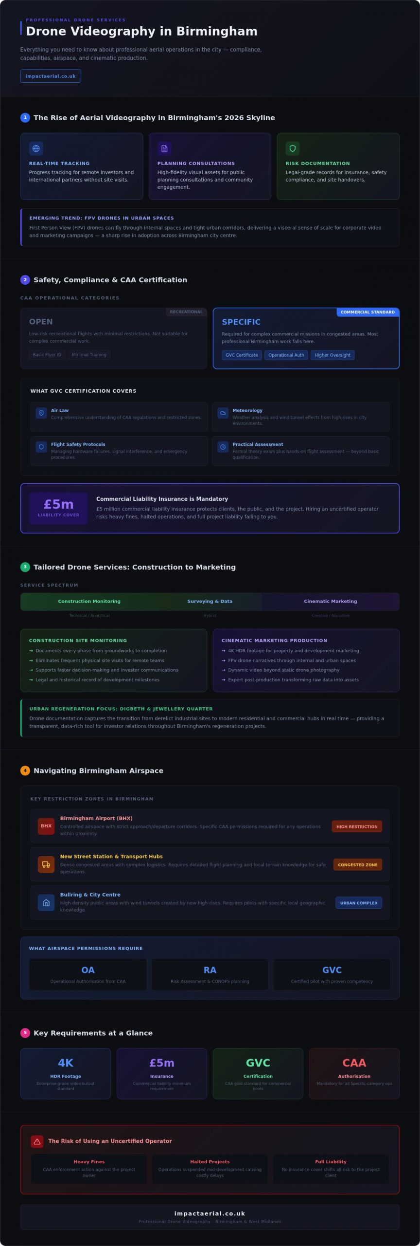
Birmingham’s skyline is undergoing its most significant transformation in decades. Driven by the ambitious Big City Plan, the city is evolving into a global hub, creating a massive demand for precise visual records. Professional drone videography birmingham services have moved from being a luxury to a critical requirement for developers, architects, and city planners. While national franchise portals offer a generic approach, they often lack the granular knowledge of Birmingham’s unique geography and the specific flight constraints of the West Midlands. Expert drone videography birmingham providers bridge the gap between technical surveying and high-end cinematic production.

Local expertise is vital. Navigating the wind tunnels created by new high-rises or managing the complex logistics of filming near the city’s transport hubs requires a pilot who understands the terrain. This isn’t just about getting a high shot; it’s about delivering 4K HDR footage that serves as a legal and historical record of the city’s growth. For stakeholders, these aerial perspectives provide strategic value that ground-based teams simply can’t replicate:

  • Real-time progress tracking for remote investors and international partners.
  • High-fidelity visual assets for public planning consultations and community engagement.
  • Risk-managed documentation for insurance, safety compliance, and site handovers.

Supporting Urban Regeneration with Drone Data

The regeneration of Digbeth and the Jewellery Quarter represents a major shift in Birmingham’s industrial identity. We use drones to document these infrastructure milestones in real-time, capturing the transition from derelict sites to modern residential and commercial hubs. High-resolution video acts as a transparent tool for investor relations. It allows project teams to inspect progress on major developments without the logistical overhead of frequent site visits, providing a data-rich perspective that supports faster decision-making and clearer communication.

Cinematic Storytelling for Birmingham Businesses

Many businesses are evolving their visual strategy, moving beyond static drone photography to embrace dynamic video narratives. While a single image captures a moment, cinematic video captures the energy of the city. We’re seeing a sharp rise in the use of FPV (First Person View) drones for corporate video within the city centre. These agile aircraft can fly through internal spaces or navigate tight urban corridors, providing a visceral sense of scale. Integrating these aerial perspectives into existing brand marketing strategies ensures that Birmingham-based companies stand out in a crowded digital marketplace.

Safety, Compliance, and the CAA: Choosing a Professional Pilot

Operating a drone in a major metropolitan area like Birmingham isn’t just about technical skill; it’s about strict legal adherence. For commercial projects, hiring an uncertified operator is a significant liability that can result in heavy fines or halted projects. Professional drone videography birmingham requires a pilot who holds a General Visual Line of Sight Certificate (GVC) from the Civil Aviation Authority (CAA). This certification ensures the operator has undergone rigorous training in air law, meteorology, and flight safety protocols, which are essential for navigating the complex urban canyons of the city centre.

Under current drone license regulations, the ‘Open’ category covers low-risk recreational flights with minimal restrictions, while the ‘Specific’ category requires operational authorization for complex commercial missions in congested areas. Most professional work in Birmingham falls under the ‘Specific’ category, necessitating a higher level of oversight and planning.

Why GVC Certification is the Gold Standard

The GVC represents a higher tier of professional competency than a basic Flyer ID. It requires a formal theory exam and a practical flight assessment, proving the pilot can manage an aircraft safely even during hardware failures or signal interference. In high-density areas, certified pilots use these skills to maintain safe distances from uninvolved persons and property. To verify a pilot’s credentials, you should always ask to see their CAA Operator ID and their GVC certificate before any work begins. This transparency is a hallmark of a professional service provider.

Mitigating Risk in Public Spaces

Filming in iconic locations like the Bullring or around New Street Station presents unique challenges. Professional operators use a detailed Risk Assessment and Method Statement (RAMS) to identify hazards, from pedestrian footfall to electromagnetic interference from railway infrastructure. A critical component of this risk management is £5m commercial liability insurance. While standard hobbyist policies might cover rural flights, urban drone videography birmingham demands high-limit coverage to protect against property damage or injury in populated environments. This insurance provides psychological comfort and tangible security for corporate and construction clients.

Pre-flight planning often takes longer than the flight itself, involving site surveys and local authority notifications. If you’re planning a complex shoot, consulting with a compliant specialist ensures your project meets every legal requirement without compromising on visual quality.

Drone Videography Birmingham: Professional 4K Aerial Filming Services

From Construction Monitoring to Marketing: Tailored Drone Services

While the visual impact of a drone videography birmingham project is immediate, its true value lies in the specialized application of the data captured. We provide a range of services that cater to the distinct needs of the West Midlands business community, from high-stakes construction monitoring to polished marketing campaigns. For construction firms, drones offer a consistent, high-resolution record of progress. Documenting a site from initial groundworks through to final completion provides a transparent audit trail for stakeholders and project managers without the need for intrusive ground-level inspections.

In the competitive world of property development, an aerial filming drone creates cinematic content that static imagery can’t match. These dynamic sequences are essential for marketing and advertising, offering prospective buyers or tenants a comprehensive view of a property’s context within the Birmingham urban environment. Beyond traditional video, we integrate virtual tours that combine 360-degree aerial perspectives with internal walk-throughs, creating a seamless experience for the viewer that builds confidence in the development.

The Post-Production Workflow

The transition from raw data to a finished asset is where professional expertise becomes most evident. Our post-production suite focuses on colour grading 4K HDR footage to achieve a consistent, cinematic look that aligns with your brand identity. For construction clients, we add motion graphics and site boundary annotations to highlight specific milestones or infrastructure points. Sound design and licensed music are also integrated to elevate corporate video productions, ensuring the final output is ready for high-level presentations or social media distribution.

Drone Surveys for Property Professionals

For property managers and RICS-qualified surveyors, drones significantly reduce both the cost and safety risks associated with traditional scaffolding or cherry pickers. Using high-resolution sensors, we identify roof defects, structural issues, or thermal leaks that are invisible from the ground. In the West Midlands, this technology is increasingly applied to PV solar farm assessments. Thermal imaging identifies failing cells or hotspots across vast arrays in a fraction of the time required for manual inspections. This data-centric approach ensures that drone videography birmingham serves as a functional tool for maintenance and asset management.

Birmingham’s airspace is among the most regulated in the UK. Successful drone videography birmingham relies on a deep understanding of these invisible boundaries. A primary consideration is the Flight Restriction Zone (FRZ) around Birmingham Airport (BHX), which extends several kilometres and covers major development sites. Operating within this zone requires specific coordination with Air Traffic Control (ATC) and often involves strict time windows to avoid interfering with commercial aviation. We manage these technical dialogues as part of our pre-flight process, ensuring your project remains legal and safe.

Sensitive urban sites like New Street Station or the BT Tower present additional layers of complexity. These locations are subject to heightened security protocols, often requiring direct liaison with the West Midlands Police and local council authorities. Weather also plays a decisive role. High winds or heavy rain in the West Midlands can compromise both safety and image stability. Due to the unpredictable nature of British weather and sudden changes in local airspace security, short-notice rescheduling is a standard precautionary measure to ensure flight safety and data quality.

City Centre Flight Challenges

High-rise environments like the city centre introduce technical hurdles such as electromagnetic interference and signal multipathing. These phenomena can disrupt the connection between the controller and the drone, requiring advanced pilot skills and enterprise-grade hardware to mitigate. We strategically select launch points, such as secure rooftops or private land near the Library of Birmingham, to maintain a clear line of sight. Coordinating with the West Midlands Police is a non-negotiable step for urban missions. It prevents unnecessary security alerts and ensures that the public remains safe and informed during the operation.

Planning for Success

Securing the necessary permissions for complex urban flights typically requires a lead time of 7 to 14 days. This window allows for a structured approach to safety:

  • Thorough site surveys and technical risk assessments (RAMS).
  • Processing of applications through the CAA or local Air Traffic Control.
  • Coordination with private landowners for secure launch and recovery sites.

We use DJI Enterprise software to plan precise flight paths, which allows us to simulate the mission before the drone leaves the ground. This technology ensures we capture the exact angles required while maintaining safe distances from buildings and people. Our goal is always to deliver high-end results with minimal disruption to your business or the public. If you have a project within a restricted zone, you can contact our team to discuss the specific permissions required for your location.

Why Impact Aerial is Birmingham’s Leading Drone Partner

Choosing a partner for drone videography birmingham projects requires a balance of local knowledge and technical sophistication. We operate as a specialized consultancy based in the West Midlands. This means our team understands the logistical nuances of the region better than a nationwide agency. We don’t just provide height; we deliver a hybrid service that blends the precision of technical surveying with the narrative power of creative videography. This dual expertise ensures that whether you need to identify a structural fault or produce a high-end marketing film, the output meets the highest professional standards.

Our commitment to safety is foundational. As we move through 2026, we continue to lead the market by adhering to evolving CAA regulations and maintaining £5m in commercial liability insurance. We also prioritize environmental responsibility by using electric-powered UAVs that minimize noise pollution and carbon footprints on-site. Every project we undertake is managed with meticulous attention to detail. This provides the psychological comfort that your brand and site are in expert hands. We live and work here. That local presence allows us to respond quickly to changing weather windows or urgent project requirements.

Our Hardware: DJI Enterprise Technology

We invest heavily in DJI Enterprise technology to ensure reliability and superior image quality. These aircraft are equipped with 4K HDR cameras that provide exceptional dynamic range, capturing detail in both high-contrast shadows and bright highlights. For urban Birmingham environments, safety is enhanced by triple-redundancy systems, including multiple IMUs and compasses, which prevent flight failures in complex signal areas. This high-tier hardware allows us to operate with a level of precision that consumer-grade drones cannot achieve. It’s about reliability in high-stakes environments.

Start Your Project Today

Our consultation process is structured and methodical. It begins with a detailed project brief where we establish your specific goals, followed by a thorough site assessment and permission phase. We offer flexible booking options, particularly for construction progress monitoring, allowing you to schedule flights around key project milestones. Once the data is captured, our post-production team delivers edited assets tailored to your requirements. We guide you from the initial brief to the final delivery with absolute transparency.

Ready to elevate your visual data? Request a professional drone videography quote for your Birmingham project today.

Elevate Your Birmingham Project with Precision Aerial Data

The transformation of the West Midlands skyline requires a sophisticated approach to visual documentation. Successful drone videography birmingham relies on more than just high-end hardware; it demands a meticulous understanding of CAA GVC compliance and the logistical complexities of restricted airspace. By integrating technical surveying with cinematic post-production, you turn raw aerial data into a strategic business asset that supports both site management and high-impact marketing.

Ensuring your project remains safe and legal is our priority. We provide the security of £5m commercial liability insurance and the expertise of pilots who are deeply familiar with the unique geography of the city. Whether you’re monitoring a major construction milestone or launching a new corporate campaign, our expert post-production suite is included to ensure every frame meets your professional standards. This comprehensive approach mitigates risk while delivering the visual clarity needed for 2026’s competitive landscape.

Book your Birmingham drone videography consultation with Impact Aerial to secure your flight window. We look forward to helping you capture the energy and scale of your next development.

Frequently Asked Questions

Do you need permission to fly a drone in Birmingham city centre?

Yes, you require specific permissions to fly a drone in Birmingham city centre for commercial purposes. Pilots must hold CAA operational authorization and often need to coordinate with the West Midlands Police or Birmingham City Council. This ensures that flights over congested areas like the Bullring remain compliant with safety regulations. We manage these permissions as part of our standard pre-flight planning process.

How much does professional drone videography cost in the UK?

Professional drone videography costs in the UK vary significantly based on the project’s complexity, location, and the level of post-production required. Factors such as the need for specific airspace permissions or the use of enterprise-grade hardware also influence the final quote. We provide bespoke pricing for each Birmingham project to ensure you only pay for the specific technical and creative resources your mission demands.

Can drones fly in Birmingham Airport’s restricted airspace?

Drones can fly within the Birmingham Airport (BHX) Flight Restriction Zone, but only with prior permission from Air Traffic Control. This process involves submitting a flight plan and obtaining a non-standard flight clearance. Our pilots are experienced in managing these technical dialogues, ensuring that your drone videography birmingham project proceeds legally without disrupting commercial aviation schedules.

What is the difference between 4K and HDR drone video?

4K refers to the resolution of the video, providing a high level of detail with roughly 8 million pixels per frame. HDR, or High Dynamic Range, relates to the camera’s ability to capture detail in both the brightest highlights and the darkest shadows. Combining 4K with HDR results in cinematic footage that looks lifelike and professional, which is essential for high-end property marketing and corporate films.

Are your Birmingham drone pilots CAA GVC certified?

Yes, all our Birmingham drone pilots are fully CAA GVC certified. This General Visual Line of Sight Certificate is the professional standard for operating in complex urban environments. It proves that the pilot has passed rigorous theory and practical assessments. This certification is mandatory for the ‘Specific’ category operations we typically conduct within the city centre to ensure absolute safety and compliance.

What happens if the weather is bad on the day of the shoot?

If the weather is unsuitable for flight, we typically reschedule the shoot to the next available clear window. Safety is our primary concern; high winds, rain, or low visibility can compromise the aircraft and the quality of the footage. We monitor specialized aviation forecasts 48 hours before takeoff. This proactive approach ensures we only fly when conditions allow for the high-quality 4K HDR results our clients expect.

Do you provide edited videos or just raw drone footage?

We provide both raw footage and fully edited cinematic videos depending on your project requirements. Our in-house post-production suite allows us to offer colour grading, motion graphics, and sound design. This service transforms raw aerial data into a polished marketing asset or a detailed construction progress report. We’ll discuss your preferred delivery format during the initial consultation to match your specific brand guidelines.

How much public liability insurance does a drone pilot need?

For commercial drone videography birmingham, a pilot should carry at least £5m in public liability insurance. While the legal minimum for some flights is lower, most corporate and construction clients require £5m to cover the risks associated with urban environments. We maintain this level of coverage as standard. It provides essential protection for people, property, and your business reputation during every mission we undertake.

Professional Drone Services in Birmingham: The 2026 Commercial Guide

In the high-stakes environment of Birmingham’s urban redevelopment, a single uncertified drone flight over the Jewellery Quarter or the city centre can result in heavy fines and catastrophic project delays. You likely recognize that while aerial data is now essential for modern construction and marketing, the risks of hiring unvetted pilots often outweigh the benefits. Managing complex Birmingham Airport (BHX) flight restriction zones and ensuring high-precision data accuracy requires a level of technical expertise that goes far beyond basic flight skills. Professional drone services birmingham bridge this gap by combining cutting-edge drone technology with rigorous safety protocols.

This comprehensive 2026 guide shows you how to secure high-resolution 4K HDR marketing content and actionable survey reports without compromising on compliance. You’ll learn how a meticulous approach to CAA GVC certification and £5m commercial liability insurance protects your reputation and your bottom line. We will break down the transition from raw aerial data to professional post-production insights, ensuring your next West Midlands project benefits from a zero-incident safety record and industry-leading visual standards.

Key Takeaways

  • Professional drone operations in Birmingham require CAA GVC certified pilots and a minimum of £5m commercial liability insurance to mitigate site risks effectively.
  • Local expertise is essential for navigating the stringent Birmingham Airport (BHX) flight restriction zones and securing the permissions needed for urban flight.
  • Utilising specialist drone services birmingham provides a safer, high-precision alternative to traditional scaffolding for commercial property and roof inspections.
  • Success depends on a full-service approach that transitions raw 4K HDR data into cinematic marketing assets or actionable technical survey reports through professional post-production.
  • A meticulous pre-flight site assessment identifies environmental hazards early, ensuring a zero-incident record on complex metropolitan projects.

What Are Professional Drone Services in Birmingham?

Professional drone services birmingham are defined by the integration of advanced Unmanned Aerial Vehicle (UAV) hardware, CAA GVC certified pilots, and sophisticated data processing. It’s a technical discipline that moves beyond simple aerial photography to provide high-precision insights for commercial stakeholders. In a city defined by its industrial heritage and rapid modern regeneration, these services offer the authoritative data required to manage complex urban projects safely and efficiently.

The industry has seen a significant shift from hobbyist-level footage to commercial-grade 4K HDR deliverables. For major Birmingham regeneration projects, such as the Curzon Street HS2 terminal or the creative redevelopment of Digbeth, the standard bird’s-eye view is no longer sufficient. Developers and marketers now demand the technical accuracy of DJI Enterprise hardware to ensure every pixel serves a purpose, whether that’s for architectural visualisation or identifying structural defects in historical masonry.

The Evolution of Aerial Data in the West Midlands

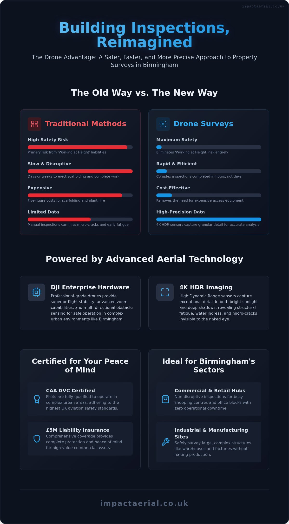
In Birmingham city centre, drones have increasingly replaced traditional, high-risk methods like scaffolding and cherry pickers. This transition reduces on-site hazards and lowers operational costs for property managers. By 2026, technology enables real-time site monitoring, allowing project leads to oversee large-scale construction from a remote office with live-streamed feeds. We’ve moved from basic imagery to complex outputs like 3D site modelling and thermal mapping. These tools allow for PV solar farm thermal surveys that identify energy inefficiencies invisible to the naked eye, providing a level of detail that was previously cost-prohibitive.

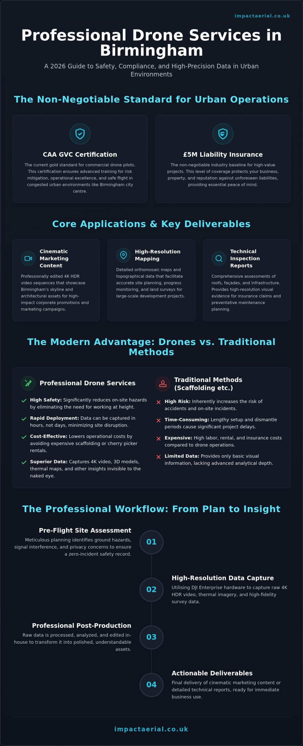
Key Deliverables You Should Expect

When you engage professional drone services birmingham, the output is tailored to specific commercial objectives. A professional partner manages the entire workflow, transitioning raw data into actionable reports through a dedicated post-production suite. You should expect a structured set of deliverables that meet industry standards:

  • Cinematic Marketing Content: Professionally edited 4K HDR sequences that showcase Birmingham’s skyline and architectural assets for corporate promotion.
  • High-Resolution Mapping: Detailed orthomosaic maps and topographical data that facilitate accurate site planning and land surveys.
  • Technical Inspection Reports: Comprehensive assessments of roofs, façades, and chimneys that provide the evidence required for insurance claims or maintenance planning.

This systematic approach ensures that every flight delivers tangible business value. It’s about providing the reassurance that your project data is accurate, compliant, and ready for immediate use in your decision-making process.

The Regulatory Standard: Safety and Compliance in 2026

Maintaining a zero-incident safety record in 2026 requires strict adherence to the General Visual Line of Sight Certificate (GVC) framework. Unlike older certifications, the GVC is the current gold standard for commercial drone services birmingham, ensuring pilots have the specific training to operate in congested urban environments. This certification isn’t just a legal checkbox; it represents a commitment to meticulous risk mitigation and operational excellence. It allows for more flexible flight patterns in built-up areas while maintaining the highest safety margins for the public and your property.

For any commercial project, £5m public liability insurance is the non-negotiable baseline. This level of coverage is the industry standard for working near Birmingham’s high-value infrastructure and residential zones. It provides the necessary reassurance that your business is protected against unforeseen liabilities. Our pre-flight process involves a rigorous site assessment that accounts for local footfall and building density, particularly in sensitive areas like Edgbaston or Solihull. Every mission includes:

  • Detailed ground hazard identification and established clearance zones.
  • Verification of local signal interference from telecommunications infrastructure.
  • Privacy impact assessments to ensure GDPR compliance in residential sectors.

Navigating Birmingham’s Restricted Airspace

A significant portion of the city falls within the Birmingham Airport (BHX) Flight Restriction Zone (FRZ). Operating here requires formal coordination with Air Traffic Control and the submission of detailed flight plans through official channels. We monitor Notice to Airmen (NOTAMs) daily to stay informed about temporary restricted areas, local helicopter activity from the Queen Elizabeth Hospital, or emergency service operations. Securing these permissions is a complex process that we manage entirely, coordinating directly with West Midlands Police and local councils when city centre access is required.

Hardware Matters: DJI Enterprise and 4K HDR

Consumer-grade drones often lack the redundancy systems and sensor quality required for professional drone services birmingham. We utilise DJI Enterprise hardware, which features dual-battery systems and advanced obstacle avoidance to ensure mission stability. For complex shoots in the city centre, a dual-operator setup allows one pilot to focus on flight safety while the other manages the camera for precision data capture. High-resolution 4K HDR sensors provide the dynamic range needed to identify minute structural cracks or thermal leaks in challenging lighting conditions, ensuring no detail is lost in the shadows. If you require a partner who prioritises these safety standards, you can learn more about our certified operations.

Professional Drone Services in Birmingham: The 2026 Commercial Guide

Core Applications: From Cinematic Filming to Precision Surveys

Professional drone services birmingham offer a dual-purpose solution that bridges the gap between high-end marketing and technical precision. Many commercial clients require cinematic visuals to attract investors while simultaneously needing accurate data for site management. By deploying DJI Enterprise hardware, we provide a unified workflow that serves both the creative and operational arms of a business, ensuring that every flight delivers maximum value. This versatility is essential for the West Midlands’ diverse economy, where industrial heritage meets cutting-edge urban redevelopment.

Construction site monitoring has become a staple for local developers. Instead of relying on ground-level snapshots, project managers use weekly aerial progress reports to track milestones from ground-breaking to completion. This visual record is invaluable for stakeholder updates and dispute resolution. Beyond construction, specialized applications like PV solar farm thermal surveys allow for the rapid identification of cell anomalies, ensuring maximum energy yield across large-scale arrays. We also provide several technical inspection outputs:

  • Detailed façade and chimney inspections for high-rise commercial buildings.
  • Volumetric measurements for stockpile management in industrial yards.
  • Comprehensive roof assessments to identify drainage issues or structural debris.

Drone Photography for Birmingham Real Estate

In a competitive market, static ground photography often fails to capture the true scale of a commercial asset. We use high-resolution drone photography to highlight property boundaries and proximity to key infrastructure like New Street Station or the M6 motorway. These aerial perspectives provide a comprehensive view that grounds a property within its local context. Additionally, virtual tour creation allows prospective buyers to explore interiors and exteriors from anywhere in the world, revolutionising how commercial listings are presented. It’s about creating a narrative that combines aesthetic appeal with logistical clarity.

Technical Surveying and Data Collection

Precision is the cornerstone of our surveying operations. Conducting a drone survey offers a safer and more efficient alternative to traditional ground methods, particularly when inspecting Birmingham’s industrial heritage sites. These structures often feature complex façades and fragile roofing that make manual access dangerous. Using 4K HDR sensors and thermal imaging, we can identify heat loss and structural defects without the need for scaffolding. This data-centric approach provides actionable insights for maintenance planning and insurance valuations, ensuring that historical assets are preserved with modern accuracy. The result is a detailed, high-resolution dataset that supports informed decision-making across the entire project lifecycle.

How to Plan Your Birmingham Drone Project

Executing a successful aerial mission in a complex metropolitan area requires more than just a skilled pilot; it demands a structured planning phase that aligns technical capabilities with your commercial goals. When you commission drone services birmingham, the first step is determining whether your priority is marketing flair or technical precision. While cinematic 4K HDR visuals sell a vision, high-accuracy survey data drives operational decisions. Identifying these objectives early ensures the correct hardware and sensor payloads are deployed for your specific West Midlands site.

Site assessments are particularly critical in Birmingham due to the density of power lines, high-rise obstructions, and public access areas. We examine the physical environment to identify potential signal interference or flight path hazards that could compromise safety. Scheduling also plays a vital role. We monitor local weather patterns to find optimal windows where wind speeds are low and lighting conditions allow our sensors to capture the highest level of detail. This preparation ensures that when we arrive on-site, the mission is ready for a safe, efficient execution.

Step 1: The Initial Consultation

During the consultation, we define the project scope and identify the specific drone license requirements for your location. This is the time to set clear Key Performance Indicators (KPIs), such as the required ground sampling distance for surveys or the specific “look and feel” for creative edits. Depending on your needs, we determine if the project requires specialized sensors like Thermal for energy audits or LiDAR for terrain mapping. If you’re ready to discuss your requirements, you can contact our Birmingham team for a technical briefing.

Step 2: Pre-Flight and On-Site Execution

Before any flight, we produce a comprehensive Method Statement and Risk Assessment (RAMS) tailored to the specific Birmingham site. These documents are essential for compliance and provide the necessary reassurance to site managers and stakeholders. On the day of the mission, we conduct safety briefings and establish cordoned take-off and landing zones to manage public risk effectively. The pilot in command maintains absolute responsibility for the safe operation of the aircraft and must prioritize the safety of uninvolved persons and property at all times during the urban mission.

Post-Production: From Data to Insights

The project doesn’t end when the aircraft lands. A professional service includes a dedicated post-production phase where raw data is processed into usable formats. For construction clients, this might mean integrating aerial photogrammetry into existing Building Information Modelling (BIM) workflows. For creative agencies, it involves professional colour grading and editing to produce cinematic sequences. This transition from raw data to actionable insights is what separates a professional operation from a basic flight service, ensuring your project receives the meticulous attention it deserves.

Why Impact Aerial Is Birmingham’s Trusted Drone Partner

Impact Aerial operates as a specialist technical consultant, providing the meticulous oversight required for complex drone services birmingham. While national franchises often prioritize volume, we focus on the high-tier quality and regulatory precision that West Midlands commercial projects demand. Our deep understanding of Birmingham’s geography, from the industrial corridors of the Black Country to the dense redevelopment zones of the city centre, allows us to deploy rapidly and safely. We don’t just provide a pilot; we provide a fully managed aerial solution that prioritizes your project’s security and data integrity.

Our commitment to uncompromising safety is the foundation of every mission. We maintain a zero-incident record by adhering to strict operational protocols, supported by CAA GVC certified pilots and £5m commercial liability insurance as standard. This provides the psychological comfort and tangible protection your business needs when operating near high-value infrastructure or public spaces. Our proven track record across the property, construction, and advertising sectors demonstrates our ability to deliver consistent, high-precision results that meet the most demanding industry standards.

The Impact Aerial Difference: Beyond the Flight

The value we provide extends far beyond the time our aircraft spends in the air. We operate a dedicated in-house post-production suite, ensuring that raw data is transformed into polished, brand-ready assets or technical reports. This full-service approach is particularly vital for drone services within the commercial property sector, where the transition from raw 4K HDR footage to a cinematic marketing sequence requires professional editing expertise. We focus on building long-term partnerships, providing consistent data delivery that allows you to track project evolution over months or years with absolute confidence.

Get Started with Your Birmingham Drone Project

Initiating your project with us is a structured and transparent process. We begin with a technical consultation to understand your specific KPIs and site constraints. To provide a bespoke quote for your West Midlands site, we typically require the project location, the desired deliverables, and any specific access requirements. This information allows us to conduct a preliminary airspace check and identify any necessary permissions from Birmingham Airport or local authorities.

Don’t leave your aerial data to chance or uncertified operators. Contact Impact Aerial today to discuss your requirements and secure a professional, compliant aerial solution for your next Birmingham project. We’re ready to provide the high-resolution visuals and accurate data your business deserves.

Elevating Your Birmingham Project with Precision Aerial Data

Birmingham’s skyline and industrial infrastructure are evolving at an unprecedented pace. To keep up, commercial stakeholders need more than just a view from above; they need actionable, high-precision data that integrates seamlessly into their professional workflows. We’ve explored how professional drone services birmingham provide this through a meticulous blend of technical skill and regulatory compliance. By prioritizing safety, you ensure your project avoids the legal and operational risks associated with uncertified flight.

Our team provides the reassurance of CAA GVC Certified Pilots and £5m Commercial Liability Insurance as standard. Safety remains our core priority. By utilizing DJI Enterprise 4K HDR Technology, we capture the minute details that matter for structural inspections and high-end marketing alike. It’s about delivering a full-service experience from the initial site assessment to the final post-production edit. If you’re ready to secure high-quality aerial insights for your site, Request a Professional Drone Service Quote for Your Birmingham Project. We look forward to helping you transform your West Midlands project with the clarity and accuracy that only professional aerial insights can provide.

Frequently Asked Questions

Do I need a permit to fly a drone in Birmingham city centre?

Commercial operations in Birmingham city centre require specific permissions due to the dense urban environment and proximity to restricted airspace. We manage the entire administrative process, including coordination with local councils and Air Traffic Control where necessary. Our GVC certification and detailed risk assessments allow us to operate within these complex environments safely while adhering to all current CAA regulations.

How much do professional drone services cost in the UK?

The investment for professional aerial work depends on project complexity, site location, and the specific deliverables required. Factors such as the need for thermal sensors, professional post-production editing, or complex airspace coordination influence the final cost. We provide bespoke quotes tailored to your West Midlands site, ensuring a transparent breakdown of the technical expertise and hardware involved in your mission.

Are your drone pilots CAA certified and insured?

Every pilot we deploy is CAA GVC certified and carries £5m commercial liability insurance as a standard safety baseline. This certification is the current industry requirement for operating professionally in urban environments like Birmingham. Our insurance coverage provides the necessary reassurance for stakeholders, protecting against unforeseen liabilities while working near high-value commercial infrastructure or public residential zones.

What happens if the weather is bad on the day of the shoot?

We monitor weather patterns meticulously and will reschedule your flight if conditions, such as high winds or heavy rain, compromise safety or data quality. Our team coordinates with you to find the next available window with optimal lighting and flight stability. This proactive approach ensures that every mission delivers the high-resolution 4K HDR results you expect without taking unnecessary operational risks.

Can drones be used for roof inspections in residential areas of Birmingham?

Drones provide a safer and more efficient alternative to scaffolding for residential roof and chimney inspections across the city. We conduct pre-flight privacy impact assessments to ensure GDPR compliance and minimize disturbance to the local community. Our high-resolution sensors allow us to identify structural defects or drainage issues from a safe distance, providing actionable data for maintenance or insurance planning.

How long does it take to receive the final edited drone footage?

Delivery times depend on the scope of the project and the level of post-production required for your data. While raw footage can often be provided shortly after the flight, professionally edited cinematic sequences or detailed survey reports typically take three to five working days. Our in-house editing suite ensures that all drone services birmingham outputs meet high-tier commercial and marketing standards.

What is the difference between a standard drone and a DJI Enterprise model?

DJI Enterprise models feature redundant systems, advanced obstacle avoidance, and superior sensor payloads compared to consumer-grade hardware. These technical advantages ensure mission stability and data accuracy in challenging urban environments. For building inspections and precision surveys, the high dynamic range of Enterprise sensors allows us to capture critical structural details that standard drones might miss in complex lighting conditions.

Can you operate drones near Birmingham Airport (BHX)?

Operating near Birmingham Airport (BHX) is possible but requires formal coordination within the established Flight Restriction Zone (FRZ). We handle all necessary applications to Air Traffic Control and ensure every flight plan is strictly followed. This professional management allows us to provide drone services birmingham even in sensitive areas, maintaining absolute compliance with national aviation safety protocols and local airport requirements.

Professional Drone Building Survey in Birmingham: The 2026 Expert Guide

Why are you still budgeting thousands of pounds for scaffolding and plant hire just to identify a few slipped tiles or a blocked gutter? In Birmingham’s complex urban landscape, traditional access methods often create more logistical headaches than they solve, leaving property managers facing high costs and significant health and safety liabilities. You likely already know that working at height remains a primary safety concern, yet the necessity of maintaining structural integrity makes these risks feel unavoidable.

This expert guide demonstrates how a professional drone building survey in Birmingham transforms these high-risk inspections into streamlined, data-driven missions. By utilizing commercial-grade DJI Enterprise hardware and 4K HDR imaging, we provide a safer and significantly faster alternative to manual surveys. You’ll discover how to achieve full compliance with the latest CAA regulations while securing the detailed structural data required for long-term maintenance planning. We will examine the specific advantages of aerial data collection across the West Midlands, from mitigating site disruption to the precision of post-production reporting that informs your critical asset management decisions.

Key Takeaways

  • Learn how DJI Enterprise sensors capture high-resolution 4K HDR data; this identifies micro-cracks and structural fatigue that manual inspections often miss.
  • Understand why CAA GVC certification and £5m liability insurance are essential benchmarks for ensuring safety and regulatory compliance in the West Midlands.
  • Discover how a professional drone building survey birmingham delivers significant ROI by eliminating the logistical costs and safety risks of traditional scaffolding.
  • Explore how aerial data collection supports Birmingham’s commercial sectors by providing precise defect identification for retail hubs and industrial sites.
  • Gain a clear framework for commissioning your next survey, including the essential details your brief must contain for accurate maintenance planning.

Drone Building Surveys: Why Essential in Birmingham?

A professional drone building survey in Birmingham is far more than a simple aerial photograph. It is a high-precision data-collection mission that utilizes Unmanned Aerial Vehicles (UAVs) equipped with 4K HDR sensors to capture granular structural details. This methodology has transformed how asset managers in the West Midlands approach maintenance, shifting the focus from basic visual inspections to comprehensive, data-driven structural analysis.

Birmingham’s unique architectural tapestry demands this level of technical sophistication. Whether you are managing sprawling industrial sites in Digbeth or sensitive heritage assets in the Jewellery Quarter, specialized aerial approaches are required to identify defects without physical contact. This non-invasive technique ensures 100% safety by removing the need for personnel to work at height while maintaining zero disruption to daily business operations.

To better understand how this technology integrates with construction and site monitoring workflows, watch this helpful video:

The Evolution of Aerial Inspections in the West Midlands

Over the last decade, drones have effectively replaced the traditional ‘man-on-a-roof’ method across the region. This transition is particularly evident in Birmingham’s 2026 urban regeneration projects, where speed and precision are paramount. Moving beyond simple photography, modern commercial drone surveys provide a digital twin of the asset, allowing for repeated, accurate measurements over time. This evolution enables property owners to track structural fatigue and water ingress with a level of detail that was previously impossible without significant manual labour.

Key Advantages Over Traditional Scaffolding

The primary driver for adopting drone technology is the total elimination of the ‘Working at Height’ risk profile. By keeping surveyors on the ground, businesses significantly reduce their liability and safety insurance concerns. The efficiency gains are equally compelling. A drone building survey in Birmingham can often complete the inspection of a complex city centre office block in just a few hours, a task that would take days to rig with scaffolding. From a financial perspective, removing the five-figure price tag associated with scaffolding hire for a simple inspection ensures that maintenance budgets are spent on actual repairs rather than access equipment.

Advanced Technical Capabilities: DJI Enterprise and 4K HDR Data

A professional drone building survey in Birmingham requires hardware that far exceeds consumer-grade capabilities. We utilize specialized professional drone systems that are recognized as the industry standard for high-stakes urban data collection. These aircraft aren’t just flying cameras; they’re sophisticated aerial platforms designed to carry advanced sensors that capture granular structural data with absolute precision.

The use of 4K HDR (High Dynamic Range) sensors is critical when inspecting Birmingham’s diverse property portfolio. HDR technology allows us to capture detail in both the brightest highlights of a glass facade and the deepest shadows of a brickwork cavity in a single frame. This clarity is essential for identifying micro-cracks, early-stage water ingress, and structural fatigue that lower-resolution equipment simply cannot detect. Beyond visual imagery, these platforms allow us to capture precise measurements and thermal data, providing a multi-layered view of a building’s performance.

Hardware Focus: Why Professional-Grade Drones Matter

Operating in the West Midlands requires equipment that can handle unpredictable weather and complex signal environments. Our professional drone systems provide the flight stability necessary to operate safely near high-rise structures, even in gusty conditions. Their advanced zoom capabilities are a significant safety feature; they allow our pilots to capture high-resolution detail from a safe stand-off distance, eliminating the risk of close-proximity flight. Furthermore, these systems feature multi-directional obstacle sensing and redundancy in their propulsion and battery systems, ensuring total reliability when flying over busy city centre streets.

From Raw Imagery to Professional Survey Reports

The value of a drone building survey in Birmingham is truly realized during the post-production phase. Raw footage is meticulously edited to enhance clarity, making it easier for structural engineers to sign off on maintenance plans. We don’t just provide a folder of images; we deliver actionable data that integrates directly into your existing property management software. This creates a permanent digital record of your building’s condition, which is invaluable for insurance renewals and long-term compliance auditing. By leveraging these advanced systems, you can secure a comprehensive drone building survey in Birmingham that provides a definitive record of your asset’s health.

Professional Drone Building Survey in Birmingham: The 2026 Expert Guide

Safety and Compliance: CAA GVC Certification in Birmingham

Executing a drone building survey in Birmingham requires more than technical skill; it demands a rigorous adherence to UK aviation law. The Civil Aviation Authority (CAA) mandates that commercial operators hold a General Visual Line of Sight (GVC) certification. This qualification ensures that pilots possess the theoretical knowledge and practical flight competence to operate safely in complex environments. At Impact Aerial, our commitment to this standard provides the foundational reassurance that every mission is conducted within the strictest legal frameworks.

Operating within a dense city centre involves unique liabilities that hobbyist-grade insurance cannot cover. We maintain £5m in commercial liability insurance as a baseline standard for all Birmingham projects. This level of coverage is essential for protecting your business interests when surveying high-value assets near public highways or adjacent properties. Our safety methodology begins long before the drone leaves the ground, involving a meticulous pre-flight planning process that accounts for local obstacles, weather patterns, and specific urban risks.

Navigating UK Drone Laws in 2026

The regulatory landscape for UAVs continues to evolve, making it vital to partner with an operator who understands the current UK drone license requirements. We maintain comprehensive flight logs and maintenance records for every aircraft in our fleet, providing a transparent audit trail for our clients. This documentation is particularly crucial when managing flights within restricted zones, such as the airspace surrounding Birmingham Airport (BHX). We handle all necessary coordination with Air Traffic Control and local authorities to ensure your survey proceeds without legal interruption.

Urban Risk Management and Public Safety

Conducting a drone building survey in Birmingham often means operating in high-footfall areas like the Bullring or Grand Central. Managing ‘uninvolved persons’ is a critical component of our safety protocol. We often deploy a dedicated observer to support the pilot, providing an extra pair of eyes to monitor the surrounding environment and ensure public safety is never compromised.

Privacy compliance is another pillar of our professional service. When capturing data in mixed-use zones where residential and commercial properties sit side-by-side, we apply strict data protection measures. Our sensors are focused exclusively on the target asset, and any incidental data is managed in accordance with UK GDPR. This meticulous approach to both physical safety and digital privacy ensures that your building survey is a low-risk, high-reward investment for your property management strategy.

Specific Applications for Birmingham’s Commercial Sectors

Birmingham’s property market requires a multifaceted approach to inspection. Whether you’re managing a high-rise office in the city centre or a sprawling warehouse in the Black Country, a professional drone building survey in Birmingham provides the specific data points needed for effective asset management. In the retail sector, we identify roofing defects and drainage issues across large-scale hubs, ensuring that structural maintenance doesn’t interfere with the customer experience. This sector-specific data allows for targeted repairs rather than costly, blanket maintenance programs.

For those looking to expand their footprint in the UK market, you can learn more about identifying and securing high-yield property deals through professional sourcing.

The Jewellery Quarter’s heritage assets present unique challenges for property owners. For these listed buildings, non-contact surveys are essential to preserve delicate masonry and intricate facades. Drones allow us to document every architectural detail without the vibration or physical risk associated with traditional access equipment. Similarly, for businesses investing in sustainable energy, our PV solar farm surveys use thermal imaging to identify cell failures and underperforming panels. This data-centric approach directly impacts ROI by ensuring maximum energy output for Birmingham’s commercial solar installations.

Construction Site Monitoring and Progress Reporting

Progress monitoring on West Midlands construction projects has moved beyond simple snapshots. We provide weekly site updates and stakeholder reports that offer a comprehensive view of development milestones. Our UAVs perform volumetric analysis for earthworks and material stockpiles, providing accurate data for site managers to track logistics. This improves on-site safety by reducing the need for manual inspections in hazardous zones or areas with active plant machinery. These digital updates ensure all stakeholders remain informed without needing to be physically present on-site.

Specialist Surveys: Thermal and 3D Virtual Tours

Our technical capabilities extend to detecting heat loss and insulation failures through specialized thermal sensors. This is a vital tool for Birmingham businesses looking to reduce energy costs and carbon footprints by identifying specific points of thermal bridging. We also combine high-resolution drone photography with interior data to create immersive 3D virtual tours. These tours are essential for property marketing and providing a complete building overview for remote stakeholders. By integrating aerial and ground-level data, we deliver a holistic view of the asset’s condition. If you need precise data for your commercial assets, you can book a drone building survey in Birmingham to secure a comprehensive structural report.

ROI and Next Steps: How to Commission a Drone Survey

Calculating the return on investment (ROI) for a drone building survey in Birmingham requires looking beyond the initial quote. Traditional access methods, such as scaffolding or cherry pickers, often incur five-figure costs before an inspection even begins. By contrast, aerial data collection eliminates these massive mobilization fees and the associated logistical delays. When you factor in the speed of delivery and the reduction in health and safety liability, the financial case for drone-based inspections becomes definitive. You aren’t just paying for a flight; you’re investing in a high-resolution data set that informs years of maintenance budgeting.

To secure an accurate proposal, your brief should be as detailed as possible. We require the specific location, building height, and the type of data output you need, such as thermal analysis or 3D modeling. Local Birmingham expertise is a significant logistical advantage here. Our deep understanding of the West Midlands airspace and local council policies allows us to reduce lead times and travel costs, ensuring your mission is executed with maximum efficiency and minimum site disruption.

Evaluating Your Drone Service Provider

Not all operators provide the same level of professional rigor. When vetting a provider for a drone building survey in Birmingham, you should use a strict checklist to ensure compliance and quality. Verify that they hold current CAA GVC certification and maintain at least £5m in commercial liability insurance. It’s also vital to ask for case studies that demonstrate their ability to operate in complex urban environments. A key differentiator is the quality of the final output. While many hobbyists offer ‘raw footage’, a professional specialist utilizes platforms like PHOTO iD to provide a structured survey report that highlights specific defects and structural concerns in a format ready for your engineering team.

Getting Started with Impact Aerial

Our process is designed to provide complete psychological comfort and technical precision. It begins with a detailed initial consultation to understand your specific data requirements. This is followed by a comprehensive site assessment where we evaluate local risks and airspace restrictions. Once the mission is complete, our post-production team meticulously reviews the 4K HDR imagery to ensure every micro-crack or insulation failure is documented. If you are ready to modernize your property management strategy, you can Request a professional drone survey quote today to receive a bespoke proposal for your Birmingham project.

Securing the Future of Your Birmingham Property Assets

Transitioning your maintenance strategy from reactive to data-driven is no longer a luxury; it’s a commercial necessity. By leveraging 4K HDR imagery and DJI Enterprise hardware, you gain a level of structural insight that traditional methods simply can’t match. We have explored how a professional drone building survey birmingham eliminates the logistical burden of scaffolding while providing the precise data required for long-term asset management.

Safety remains the foundation of every mission. With our CAA GVC certified pilots and £5m commercial liability insurance, you can be confident that your property inspections are handled with meticulous care. Our deep expertise in Birmingham urban airspace ensures that even the most complex city centre projects are executed without legal or operational friction. It’s time to replace high-risk manual inspections with a faster, safer, and more cost-effective digital solution.

Book Your Birmingham Drone Building Survey with Impact Aerial and take the first step towards smarter property maintenance. We look forward to helping you protect your structural investments with precision and reliability.

Frequently Asked Questions

Is a drone building survey legal in Birmingham city centre?

Yes, conducting a drone building survey in Birmingham city centre is entirely legal when performed by a CAA GVC certified operator. We coordinate with local authorities and Birmingham City Council to ensure every flight adheres to specific urban airspace regulations. Our pilots manage all necessary permissions, including coordination with Air Traffic Control if the site falls within restricted zones like the Birmingham Airport (BHX) catchment area.

How much does a drone building survey cost compared to scaffolding?

A drone survey typically costs a fraction of traditional scaffolding because it eliminates the high expense of plant hire and manual labor. While we don’t quote fixed industry rates, businesses save significantly by removing the need for 5-figure scaffolding setups. You pay for a specialized data-collection mission rather than weeks of site disruption and heavy equipment rental, making it a far more efficient allocation of your maintenance budget.

What happens if the weather is bad on the day of the survey?

If weather conditions exceed safe operating limits, we simply reschedule the mission to the next available window at no additional cost. High winds or heavy rain can compromise the stability of the DJI Enterprise hardware and the quality of the 4K HDR data. We monitor localized West Midlands weather patterns meticulously in the 48 hours leading up to a flight to ensure the safest and most accurate results possible.

Do I need to notify my neighbours or Birmingham City Council before a flight?

Professional operators handle most notifications as part of their pre-flight planning process. While you don’t usually need formal permission from neighbours, we recommend informing adjacent occupants as a matter of courtesy. Regarding the local council, we manage any specific requirements for flying over public highways or council-owned land. Our privacy protocols ensure that data collection remains strictly focused on your specific commercial asset.

How long does it take to receive the final survey report and images?

You will typically receive your processed imagery and detailed report within three to five working days. This timeframe allows our post-production team to meticulously review the raw footage and enhance the clarity of structural data for your engineers. This is significantly faster than traditional manual surveys, which often require weeks to compile comprehensive reports and coordinate site access for multiple personnel.

Can drones detect internal building issues like leaks or heat loss?

Drones detect external indicators of internal structural problems, such as thermal bridging, heat loss, or moisture ingress. By using advanced thermal sensors, we can pinpoint exactly where insulation has failed or where water is trapped behind a facade. This non-invasive method identifies the source of internal leaks and energy inefficiencies without needing to perform destructive testing on the building’s interior.

What insurance coverage should a professional drone pilot have?

A professional pilot must hold specialist commercial UAV insurance, with £5m liability coverage being the industry standard for urban projects. This specific coverage protects your business against unforeseen incidents in high-density environments like Birmingham city centre. It’s essential to verify that your provider’s insurance is current and explicitly covers commercial operations rather than simple hobbyist flight, providing you with total psychological comfort during the survey.

Is the drone survey data accurate enough for a structural engineer’s report?

The data captured during a drone building survey in Birmingham is highly accurate and specifically tailored for structural engineering requirements. Our 4K HDR cameras identify micro-cracks and material fatigue with a level of detail that often surpasses what a surveyor can see from a ladder. This high-resolution digital record provides a definitive baseline for engineers to sign off on maintenance plans and structural safety certificates.

Professional Construction Photographer in Birmingham: The Complete Guide

A construction site is a high-stakes environment where a single missed detail can lead to costly delays or compliance failures. Finding a qualified construction photographer birmingham developers can rely on involves more than just checking a portfolio; it requires verifying site-readiness and technical precision. You likely understand the frustration of working with photographers who lack CSCS cards, ignore PPE protocols, or fail to grasp the nuances of CAA drone regulations. It’s a risk your project shouldn’t have to take.

This guide will show you how expert aerial and ground photography transforms site monitoring, ensures total safety compliance, and creates the high-end marketing assets needed to win future West Midlands contracts. You’ll discover how 4K HDR imagery and £5m liability insured drone surveys provide the technical data stakeholders demand. We’ll examine the shift from simple progress shots to critical data assets that serve both your site managers and your marketing team with zero operational disruption. From meeting Building Regulations Part L requirements to securing your next major tender, professional imagery is now a fundamental pillar of project success.

Key Takeaways

  • Learn why CSCS cards and full PPE are non-negotiable for site visits to ensure zero disruption and total health and safety compliance.
  • Understand the transition from PfCO to CAA GVC certification and why it’s a critical requirement for legal aerial site monitoring.
  • Discover how a professional construction photographer birmingham provides the 4K HDR data needed to meet Building Regulations Part L requirements.
  • Identify key project milestones, from groundbreaking to topping out, that offer the highest return on investment for your marketing and tender documents.
  • Compare the benefits of ground-level craftsmanship shots with professional aerial drone perspectives to build a complete visual record of your project.

The Role of a Construction Photographer in Birmingham’s Evolving Skyline

Birmingham is currently navigating its most ambitious growth period in a generation. With the “Big City Plan” setting a twenty year trajectory for urban regeneration, the demand for a professional construction photographer birmingham developers can rely on has never been higher. This role has evolved far beyond simple site visits. It’s now a technical necessity for documenting the massive structural shifts occurring across the West Midlands. High-tier site documentation provides a verifiable record of progress that satisfies investors, planning committees, and regulatory bodies alike.

While site managers often use smartphones for internal memos, these devices cannot produce the high-resolution, wide-angle imagery required for professional Architectural Photography. Professional equipment and technical expertise are essential when building a tender-winning portfolio. Visual storytelling allows Birmingham contractors to demonstrate their precision and safety standards, which is vital for securing public trust and future investment. A well-documented project proves a firm’s capability to handle complex engineering challenges in a dense urban environment.

Documenting Birmingham’s Major Infrastructure Projects

The sheer scale of current works in the city centre requires a specialized approach to documentation. Capturing the vast footprint of HS2 and the Curzon Street Station development demands both ground-level detail and aerial perspectives to show the project’s relationship with the existing city grid. These long-term urban regeneration projects rely on consistent progress photography to keep stakeholders informed over several years of construction. In areas like the Jewellery Quarter and the Smithfield redevelopment, the focus often shifts toward showcasing craftsmanship and the integration of new structures with historic heritage. A specialist photographer ensures that the preservation of historic facades is documented with the same technical precision as the installation of modern steel frameworks.

Why ‘Local’ Matters for Construction Photography

Proximity is a significant logistical advantage on a busy Birmingham site. A local construction photographer birmingham based can respond rapidly to critical milestone events, such as concrete pours or complex crane lifts, which often depend on precise timing and weather windows. This local presence ensures that no major project phase goes undocumented due to travel delays.

Working with a local specialist offers several distinct benefits:

  • Airspace Expertise: Deep knowledge of Birmingham’s specific flight restrictions, particularly near the city centre and Birmingham Airport.
  • Regulatory Knowledge: Familiarity with Birmingham City Council’s documentation requirements for major planning permissions and discharge of conditions.
  • Operational Efficiency: Established relationships with regional site managers, ensuring faster site inductions and minimal disruption to active trades.

Building long-term partnerships with West Midlands firms allows for a consistent visual style across a company’s entire regional portfolio. This consistency is a powerful tool for brand authority, showing a track record of successful delivery across the city’s most challenging sites.

While professional photography captures the quality of your work on-site, your vehicles represent your brand on the move; many UK construction firms use 3Sixty Sign Kits to ensure their vans look as professional as their project documentation.

Safety and Compliance: The Non-Negotiables for Site Photography

Safety is the primary consideration on any West Midlands project. A professional construction photographer birmingham specialist treats compliance as a core deliverable, ensuring that documentation never comes at the cost of site security. Every visit requires a valid CSCS card and a full set of Personal Protective Equipment (PPE), including a hard hat, high-visibility vest, and safety boots. These requirements align with HSE construction safety guidelines, which dictate that all site visitors must be properly equipped and inducted to mitigate risks in high-hazard environments. It’s not just about getting the shot; it’s about doing so without creating new liabilities for the principal contractor.

The regulatory landscape for aerial work has shifted significantly. While many providers still reference the old PfCO (Permission for Commercial Operation), the industry has transitioned to the CAA GVC (General Visual Line of Sight Certificate). This newer certification is a critical distinction for 2026, as it proves a pilot has the advanced technical knowledge required to operate safely in congested urban areas. Meticulous planning is essential, and the provision of site-specific Risk Assessments and Method Statements (RAMS) remains the photographer’s responsibility to ensure every operation is vetted before the first shutter click.

CAA Regulations and Urban Drone Flight

Flying drones in Birmingham’s congested city centre requires more than just a pilot’s license. The GVC certification is vital for ensuring legal and safe aerial photography when operating near busy thoroughfares or high-rise structures. Impact Aerial manages all flight permissions and coordination with local authorities, which is especially important when working near sensitive infrastructure like the West Midlands rail network or major utility hubs. This proactive management prevents legal complications and ensures that 4K HDR site data is captured within the strict confines of national aviation law.

Insurance and Risk Mitigation

Standard public liability insurance often excludes aviation-related incidents, making specialised UAV insurance a mandatory requirement for any credible provider. Major sites in Birmingham typically set £5m commercial liability insurance as the baseline for all contractors. This £5m commercial liability insurance protects the main contractor’s interests by ensuring that any unforeseen incidents involving high-value urban assets or public safety are fully indemnified. High-tier insurance provides the reassurance that the project remains protected against the unique risks associated with commercial drone operations. Project leads can ensure their documentation meets these rigorous standards by partnering with a provider focused on construction site monitoring and safety.

Professional Construction Photographer in Birmingham: The Complete Guide

Drone vs. Ground Photography: Choosing the Right Approach

Effective site documentation requires a dual-perspective strategy. While ground-level work captures the intricate craftsmanship of a build, aerial views provide the context of scale and site planning. A specialist construction photographer birmingham developers engage should offer a hybrid service that blends these viewpoints. This approach ensures that 4K HDR imagery serves two distinct purposes: high-detail technical site assessments for engineers and compelling visual assets for marketing brochures and investor reports. Relying on a single perspective often leaves gaps in the project record, whereas a combined method provides a comprehensive narrative of the build’s evolution.

The Advantages of Aerial Site Monitoring

Aerial perspectives are transformative for tracking progress across large-scale West Midlands developments. Utilizing DJI Enterprise grade drones allows for precise site mapping and repeatable flight paths, providing consistent data for stakeholder reporting. These tools are invaluable for roof inspections and structural assessments of hard-to-reach areas, significantly reducing the need for scaffolding or manual climbing. All operations are conducted in strict accordance with UK drone regulations, ensuring that data collection is both legal and safe. By integrating aerial data into project management workflows, teams can identify potential logistical bottlenecks before they impact the construction schedule. This data-centric approach provides a level of site oversight that was previously impossible without significant expense.

Capturing the Human Element on Site

Ground-level photography complements aerial data by focusing on the technical engineering feats and the workforce behind them. These shots highlight specialized machinery in action and demonstrate a firm’s commitment to rigorous health and safety practices. Capturing the human element provides an authentic narrative for tender documents, showing the faces and skills driving the project forward. It’s these detailed images of craftsmanship that often resonate most with potential clients during the bidding process; for specialized surfacing contractors like Wolverhampton Driveways Ltd, this visual proof is essential for showcasing quality to regional developers.

As a project moves toward the final stages, the focus shifts to internal photography. Documenting completed residential and commercial spaces requires a different technical skill set, focusing on lighting and composition to showcase the internal fit-out. A construction photographer birmingham firms trust will manage this transition seamlessly, moving from the raw data of a structural build to the polished imagery required for a building’s handover. This comprehensive visual record is essential for long-term site monitoring and provides a powerful asset for future business development.

Planning Your Construction Shoot for Maximum ROI

Planning is the difference between a collection of random images and a strategic data asset. A professional construction photographer birmingham firms rely on will work closely with your project team to identify high-value moments that offer the best return on investment. This process begins by defining the primary purpose of the imagery. If the goal is a tender bid, the focus remains on technical precision and safety compliance. For social media or investor reports, the emphasis shifts toward the architectural aesthetic and the project’s impact on the West Midlands skyline.

Effective coordination with site managers ensures that photography occurs during peak activity without causing disruption to active trades. Scheduling visits around major milestones like groundbreaking, topping out, and final completion creates a cohesive narrative of the build. Post-production is the final stage of this value chain. Professional editing involves more than basic adjustments; it includes perspective correction and the removal of temporary site clutter to ensure the final imagery reflects a high-tier professional standard. A dedicated construction photographer birmingham specialist ensures these edits maintain the integrity of the structural data while enhancing the visual appeal.

The Construction Milestone Checklist

A structured approach to site visits provides a verifiable timeline for all stakeholders. Initial site surveys capture “before” shots that provide essential context for planning and insurance purposes. Regular monthly progress visits maintain transparency, allowing investors to see tangible development throughout the project lifecycle. The final phase focuses on architectural “hero” shots, which are critical for your company’s long-term marketing portfolio and future business development. These images are often the deciding factor when stakeholders review your past performance for upcoming tenders.

Maximising Value from a Single Site Visit

Efficiency is key on an active construction site. Capturing high-resolution stills and 4K video content simultaneously allows a single visit to serve multiple departments, from engineering to marketing. Prioritising high-impact areas, such as complex structural installations or unique architectural features, ensures you have engaging content for social media and press releases. Integrating virtual tour creation for internal showcases provides an immersive way for stakeholders to explore the site remotely, adding a layer of depth that standard photography cannot match.

By aligning your visual documentation with project milestones, you ensure every shutter click contributes to your firm’s growth. To begin planning your next project’s visual strategy, consider our professional construction site monitoring services to ensure total site transparency and high-end marketing output.

Impact Aerial: Birmingham’s Trusted Construction Photography Partner

Impact Aerial operates at the intersection of technical precision and visual excellence. As a leading construction photographer birmingham specialist, we understand that site documentation is far more than a collection of images; it’s a critical safety and data asset. Our operations are built on a foundation of CAA GVC certified pilots and £5m commercial liability insurance, providing the reassurance that your project is in expert hands. We utilize DJI Enterprise technology to capture 4K HDR data that serves both rigorous technical site assessments and high-end marketing requirements. This commitment to precision ensures that every West Midlands project we document meets the highest standards of professional accountability.

Being based in Birmingham allows us to act as a technical consultant for our clients rather than just a service provider. We understand the logistical nuances of the city, from the specific flight restrictions near the airport to the high-density requirements of the city centre. Our goal is to provide a seamless service that integrates with your existing site workflows, delivering high-quality visual data with zero operational disruption. This local expertise is why major contractors across the region choose us to manage their visual documentation strategies.

Expertise in the West Midlands Construction Sector

Our team has extensive experience navigating the unique challenges of the West Midlands construction sector. From documenting the structural evolution of HS2 and the Curzon Street development to supporting the large-scale regeneration projects defined by the “Big City Plan,” we provide a consistent visual record for local developers and project managers. We’ve worked on some of the city’s most iconic recent builds, ensuring that every phase of craftsmanship is recorded with absolute clarity. This track record of delivery across complex urban environments makes us the ideal partner for firms looking to showcase their capabilities in a competitive market. To understand how our regional expertise fits into a wider national context, you can learn more about our professional drone services in the UK.

Get a Quote for Your Birmingham Project

We provide transparent pricing models designed to scale with your project’s specific needs, whether you require a one-off milestone shoot or long-term monthly construction photographer birmingham monitoring. Every bespoke proposal we provide is comprehensive and includes the following as standard:

  • Safety Documentation: Detailed site-specific RAMS and proof of £5m liability insurance.
  • Operational Coordination: Direct liaison with site managers to ensure minimal trade disruption.
  • Post-Production: High-resolution editing and perspective correction for an architectural aesthetic.
  • Secure Delivery: Rapid turnaround of all 4K HDR assets via secure digital transfer.

Our Birmingham team is ready to assist with your next project. Contact us today for a bespoke site photography proposal and discover how high-tier visual documentation can support your site safety, monitoring, and business development goals.

Securing Your Project Legacy Through Precision Documentation

Birmingham’s skyline is changing rapidly, and the need for meticulous site documentation has never been more critical. By integrating professional imagery into your workflow, you ensure total compliance with modern safety standards while building a powerful visual asset for future tenders. Whether you’re navigating the complexities of city centre drone flight or documenting internal craftsmanship, the right technical partner provides the reassurance that every milestone is recorded with absolute clarity. It’s about turning visual data into a strategic advantage for your firm.

Selecting a specialist construction photographer birmingham firms can rely on means prioritising safety, precision, and regional expertise. Impact Aerial offers exactly that through our CAA GVC Certified Pilots and £5m Commercial Liability Insurance. Our Birmingham-Based Rapid Response Team is ready to capture your site’s evolution with zero operational disruption, ensuring that high-tier 4K HDR data is always available when stakeholders need it most.

Request a Bespoke Construction Photography Quote for Your Birmingham Site today to enhance your project monitoring and marketing output. We look forward to helping you showcase the high-tier quality of your West Midlands developments through expert visual storytelling.

Frequently Asked Questions

Do your construction photographers have CSCS cards?

Yes, all our pilots and photographers hold valid CSCS cards to ensure seamless access to your site. This certification demonstrates our commitment to health and safety awareness on active developments. We arrive fully equipped with the necessary PPE, including hard hats, safety boots, and high-visibility vests. By maintaining these standards, we ensure that our presence on your project never compromises your site’s safety protocols or operational efficiency.

Are you insured to fly drones on active construction sites in Birmingham?

We carry £5m commercial liability insurance specifically tailored for professional drone operations on complex urban sites. This level of coverage is a mandatory standard for major Birmingham projects and protects your interests against unforeseen incidents. Our insurance covers both ground-level work and aerial surveys. This provides the reassurance that your project remains fully indemnified while a construction photographer birmingham specialist documents your site’s progress from every angle.

What is the difference between a standard drone and a DJI Enterprise drone for construction?

DJI Enterprise drones are designed for technical data collection rather than simple creative filming. These models offer superior stability, high-resolution 4K HDR sensors, and RTK precision for accurate site mapping. Unlike consumer models, enterprise hardware can integrate with BIM workflows and provide the technical detail required for professional site monitoring. This ensures that the imagery we deliver serves as a reliable data asset for your engineering and management teams.

Can you provide both aerial and ground-level photography in one visit?

We offer a hybrid service that captures both ground-level craftsmanship and aerial perspectives in a single visit. This approach provides a comprehensive record of your project, from internal fit-outs to the overall site scale. Capturing these different viewpoints simultaneously is highly efficient and minimises trade disruption. It ensures your marketing team has a diverse bank of assets while your project managers receive the technical progress shots they require.

How quickly can I expect the edited photos after the site visit?

High-resolution edited imagery is typically delivered via a secure digital transfer within 48 hours of the site visit. We understand that stakeholder reporting and marketing deadlines are often time-sensitive. Our post-production process includes professional perspective correction and colour grading to ensure an architectural aesthetic. If your project requires a faster turnaround for a specific milestone or press release, we can often accommodate urgent requests through our Birmingham-based editing team.

Do you handle the risk assessments and CAA flight permissions?

We manage all site-specific Risk Assessments and Method Statements (RAMS) along with necessary CAA flight permissions. Our pilots are CAA GVC certified, meaning they have the advanced training required to coordinate legally in congested urban environments. We handle the complex logistics of flying near sensitive Birmingham infrastructure, such as rail lines or high-rise structures. This comprehensive management ensures that your aerial documentation is fully compliant with national aviation laws.

What happens if the weather is too poor for drone photography on the scheduled day?

If the weather conditions are unsafe for flight, we simply reschedule the session for the next available clear window at no additional cost. Safety is our non-negotiable priority, and we monitor local Birmingham forecasts closely leading up to every shoot. While ground-level photography can often proceed in minor rain, aerial work requires stable conditions. We maintain clear communication with site managers to ensure the new schedule aligns with your project’s milestones.

Can construction photography help my firm win more tenders?

Professional imagery is a powerful tool for proving your firm’s capability and safety standards during the tender process. High-quality 4K HDR shots demonstrate a track record of successful delivery and attention to detail that smartphone photos cannot match. Including professional site documentation in your bid shows potential clients that you take project monitoring and transparency seriously. A construction photographer birmingham specialist helps you build a compelling visual portfolio that secures investor trust.

Professional Birmingham Aerial Videography Guide 2026

In the densely packed urban corridors of the West Midlands, the difference between a stunning marketing asset and a significant legal liability often comes down to a single pilot’s certification. You’ve likely seen the potential of aerial perspectives to elevate your brand, but the complexity of 2026 UK drone regulations can make the process feel like a technical minefield. Whether you require high-end marketing footage or a precise drone building inspection birmingham wide, the stakes for safety and compliance have never been higher.

We understand that hiring a pilot shouldn’t feel like a gamble. This guide will demonstrate how professional Birmingham aerial videography integrates cinematic 4K HDR quality with rigorous CAA safety standards to provide total peace of mind. We’ll examine the latest UK0 to UK6 classification systems, the new Remote ID requirements, and how advanced DJI Enterprise technology delivers the accurate data and visual excellence your commercial projects demand.

Key Takeaways

  • Learn why 4K HDR resolution and DJI Enterprise technology are essential for achieving broadcast-quality stability and data precision in commercial filming.
  • Understand the 2026 CAA GVC requirements and why expert navigation of Birmingham’s complex urban airspace is vital for legal compliance and risk mitigation.
  • Discover how a professional drone building inspection birmingham provides accurate construction monitoring and high-resolution data for site stakeholders.
  • Explore the strategic advantages of using cinematic aerial perspectives to showcase Birmingham’s unique architectural landscape for high-impact commercial property marketing.
  • Gain insights into the meticulous professional workflow required for West Midlands projects, from initial airspace consultation to final post-production delivery.

The Evolution of Aerial Videography in Birmingham

The skyline of the West Midlands has undergone a radical transformation, and the technology used to document it has followed suit. The Evolution of Aerial Videography has moved rapidly from the era of shaky, hobbyist-grade gadgets to the deployment of sophisticated DJI Enterprise tools. In a city like Birmingham, where ultra-modern developments sit alongside historic landmarks, the demand for precision has never been higher. Professional drone building inspection birmingham services now provide a level of detail that was previously impossible without significant logistical overhead.

Operating in Birmingham presents unique challenges that only an expert pilot can manage. Navigating the tight urban corridors of the Jewellery Quarter or the open, wind-swept spaces of Victoria Square requires more than just basic flight skills. It demands an understanding of local micro-climates and complex airspace restrictions. We’ve moved far beyond the days of hiring expensive chartered planes or helicopters to get a single wide shot. Modern 4K HDR drones offer a versatile, stable platform that captures every architectural nuance while remaining compliant with strict CAA safety standards. This shift doesn’t just save money; it provides a fresh perspective that transforms how developers and stakeholders analyse their sites.

Why Birmingham Businesses are Choosing Aerial Content

Commercial entities in the West Midlands are increasingly using aerial perspectives to gain a competitive edge. It’s no longer enough to show a static ground-level photo of a new development. High-altitude visuals provide a sense of scale and brand authority that traditional photography can’t match. From a practical standpoint, a drone building inspection birmingham project is a fraction of the cost of erecting scaffolding or hiring a cherry picker. This efficiency allows for more frequent monitoring, ensuring that site managers have up-to-date data without the typical downtime associated with traditional survey methods.

Aerial Videography vs. Ground-Based Filming

While ground-based cameras are excellent for capturing human-scale interactions, they fail to convey the true footprint of major infrastructure projects. Drones bridge this gap by capturing the entirety of a construction site in a single, high-resolution frame. We can create immersive fly-through experiences that guide potential tenants through a commercial development before the first brick is even laid. By integrating these cinematic shots into existing corporate video programmes, businesses can achieve a high-end, broadcast-quality feel. This approach ensures that every stakeholder, from investors to local authorities, sees the project through a lens of technical excellence and professional reliability.

Technical Standards: 4K HDR and DJI Enterprise Technology

Achieving broadcast-quality results in a city as architecturally diverse as Birmingham requires more than just a standard consumer drone. For a professional drone building inspection birmingham, the technical specifications of the hardware are the foundations of every successful project. Impact Aerial employs industry-leading professional drone systems because they offer the stability and data precision required for high-stakes urban environments. Our advanced hardware represents the industry benchmark for reliability, reflecting the dominant market share held by top manufacturers in enterprise applications as of 2026. When you’re filming near the Bullring or the new HS2 developments, the ability to maintain a 4K HDR feed while navigating complex magnetic interference is a non-negotiable requirement for safety and quality.

The UK Civil Aviation Authority (CAA) has strict guidelines for Navigating Birmingham Airspace, especially given the proximity of Birmingham International Airport. Our Impact Aerial professional fleet is equipped with advanced obstacle avoidance and Remote ID technology, ensuring every flight is as compliant as it is visually stunning. This hardware isn’t just about the camera; it’s about the redundant systems that keep the aircraft stable in the gusty conditions often found around Birmingham’s high-rise structures. Balancing a large camera sensor with the agility needed for tight city centre flights is a technical challenge that only professional-grade equipment can solve.

The Professional Fleet Advantage

Our advanced professional fleet provides three critical advantages for West Midlands commercial projects. First, omnidirectional obstacle sensing is essential for safe navigation in congested city centres and near delicate heritage buildings. Second, High Dynamic Range (HDR) is crucial for maintaining detail during the flat, grey light conditions common in the UK. Finally, advanced battery management allow for comprehensive site coverage in a single flight, which is particularly useful for a drone building inspection birmingham where time on-site must be minimised.

From Raw Footage to Polished Edit

Capturing the footage is only the first stage of our workflow. Raw aerial data is often flat to allow for maximum flexibility in the edit. Our post-production services transform these files into cinematic marketing assets through expert colour grading and sound design. For construction site monitoring, we integrate professional graphics and data overlays that clearly show project milestones to stakeholders. Whether you need a punchy 15-second clip for social media or a detailed 10-minute progress report, we optimise every delivery format for its intended audience. If you’re ready to see how high-end tech can elevate your next project, you can explore our drone survey and data collection services.

Professional Birmingham Aerial Videography Guide 2026

Safety and Compliance: Navigating Birmingham Airspace

Birmingham’s urban landscape presents a sophisticated challenge for aerial operations, primarily due to its complex airspace and dense population centres. Much of the city, particularly the eastern corridors, sits within the Flight Restriction Zone (FRZ) of Birmingham International Airport (BHX). Conducting a professional drone building inspection birmingham in these areas isn’t just about pilot skill; it’s about meticulous legal coordination with Air Traffic Control. The UK Civil Aviation Authority (CAA) updated the regulatory framework on 1 January 2026, introducing the UK0 to UK6 classification system. We ensure every flight remains fully compliant with these latest standards, including the mandatory use of Remote ID for all new enterprise aircraft.

Risk mitigation is the cornerstone of our operational philosophy. Before any rotors turn, we conduct comprehensive site surveys and desk-based assessments to identify potential hazards, from high-tension power lines to local micro-climates. To protect our clients from unforeseen liabilities, we carry £5m commercial liability insurance as a standard requirement. This level of coverage is essential for West Midlands businesses that value security and professionalism over the risks associated with uncertified operators.

Why GVC Certification Matters

The legal distinction between a hobbyist and a professional provider of drone services has never been clearer. For commercial work in congested urban areas, a pilot must hold a General Visual Line of Sight Certificate (GVC). This qualification demonstrates a high level of airmanship and a deep understanding of the 2026 drone license regulations. Our commitment to these safety protocols ensures that every drone building inspection birmingham project is executed within the strict confines of the law, protecting your brand’s reputation and ensuring the safety of the public.

Urban Risk Management

Managing flight paths over public spaces like Centenary Square or the Bullring requires a disciplined approach to urban risk. We don’t just focus on the flight itself; we manage the entire operational environment. This includes:

  • Implementing strict cordons and using spotters to manage ground-level safety.
  • Adhering to GDPR and privacy regulations to ensure that bystanders and neighbouring properties are protected.
  • Securing specific permissions for filming near sensitive heritage sites or government buildings.

By handling these logistical hurdles, we allow our clients to focus on the results. Whether we’re navigating the historic Jewellery Quarter or modern infrastructure projects, our goal is to provide total psychological comfort through technical and regulatory excellence.

Industry Applications for Aerial Video in the West Midlands

The versatility of UAV technology has made it an indispensable tool across diverse sectors in the West Midlands. In commercial property, we move beyond simple snapshots to create high-impact real estate photography and cinematic video that captures the full context of a development. This isn’t just about aesthetics; it’s about providing a comprehensive view of transport links and local amenities that ground-level cameras cannot reach. For the construction sector, construction site monitoring has become the standard for stakeholder reporting, allowing project managers to track progress with high precision. Beyond marketing and construction, our PV solar farm thermal surveys and critical infrastructure inspections support the region’s energy sector. Even the tourism and advertising industries benefit, as we showcase Birmingham’s vibrant culture and large-scale events from perspectives that reveal the city’s true scale.

Property and Development Marketing

Selling a location requires more than just showing the building. It’s about highlighting the proximity to New Street Station or the accessibility of the M6. We create immersive virtual tours that provide a seamless experience for potential tenants, driving enquiries by allowing them to explore a space before a physical visit. Capturing luxury residential developments in Digbeth or the Jewellery Quarter during the golden hour provides that aspirational quality that high-end brands demand. These visuals don’t just show a property; they sell a lifestyle and a strategic location to global investors.

Technical Surveys and Inspections

The use of specialized survey drones has revolutionized how we approach maintenance. Executing a drone building inspection birmingham wide allows for detailed roof and facade analysis without the cost or risk of scaffolding. We provide thermal imaging that identifies heat loss or moisture ingress, facilitating preventative maintenance for commercial landlords and facility managers. This data-centric approach is equally valuable for topographical mapping and large-scale land development projects. If you need to secure accurate data or cinematic marketing assets for your next West Midlands project, you can contact our professional aerial filming team today.

The Impact Aerial Workflow: From Concept to Delivery

Professional aerial operations require more than just technical skill; they necessitate a structured, methodical workflow that prioritises client goals and aviation safety. We approach every project as a technical consultancy, ensuring the transition from initial concept to high-end delivery is seamless and compliant. Whether we’re conducting a high-resolution drone building inspection birmingham wide or capturing cinematic marketing assets, our process is designed to provide total psychological comfort through every phase of the mission.

Step 1: Consultation and Planning

The process begins with a deep dive into your specific project requirements. We define the brief and identify the exact deliverables you need, whether that’s raw thermal data for a solar farm or a polished promotional film for a new commercial development. During this stage, we handle the complex logistics of securing permissions for restricted urban areas and private land. We monitor weather patterns and sun positions to schedule flights for optimal lighting conditions. This meticulous planning phase is where we conduct our site-specific risk assessments, ensuring every operational detail is locked down before we arrive on-site.

Step 2: Professional Execution and Editing

On-site, our GVC certified pilots execute the flight plan with surgical precision. We understand that commercial sites are busy environments, so we conduct our operations with minimal disruption to your daily business activities. If we’re performing a drone building inspection birmingham for a construction firm, we ensure all data points are captured systematically and safely. We often review raw footage with clients while on-site to allow for immediate feedback and any necessary adjustments.

Once the flight is complete, the project moves to our post-production suite. Here, we transform raw data into an aerial filming drone masterpiece. This includes professional colour grading, sound design, and the integration of graphics or data overlays. The result is a high-tier visual asset delivered via secure file transfer, ready for broadcast, social media, or stakeholder reporting. Our workflow ensures that the final output isn’t just a video, but a strategic tool that meets your specific business objectives.

Securing the Future of Your West Midlands Projects

Professional aerial videography has evolved into a critical technical service that balances cinematic artistry with rigorous aviation compliance. By choosing a specialist who understands the nuances of Birmingham’s urban airspace, you’re investing in more than just footage; you’re securing a compliant, high-resolution data asset. Whether your project requires a technical drone building inspection birmingham or a high-impact marketing campaign, the combination of 4K HDR technology and meticulous planning ensures a superior outcome.

As Birmingham and West Midlands specialists, we provide the technical expertise and legal assurance your business demands. Our GVC certified pilots operate with £5m public liability insurance, using industry-leading DJI Enterprise hardware to deliver precision in every frame. We manage the entire process, from complex airspace permissions to final post-production, so you can focus on your project’s success with total peace of mind.

We’re ready to help you transform your next commercial development with stunning visuals and accurate data. Request a Professional Aerial Videography Quote for Your Birmingham Project and take the first step towards a safer, more cinematic perspective.

Frequently Asked Questions

Do you need a permit to fly a drone in Birmingham city centre?

Yes, operating a drone in Birmingham city centre requires specific permissions due to the dense urban environment and proximity to Birmingham International Airport. As the city falls within complex airspace, professional pilots must coordinate with Air Traffic Control and potentially local authorities. Our GVC certified pilots manage these logistics as part of our standard workflow to ensure every flight is fully legal and safe.

How much does aerial videography in Birmingham typically cost?

The cost of professional aerial services depends on the project’s complexity, the required hardware, and the level of post-production needed. Factors such as the location’s risk profile and the duration of the shoot also influence the final investment. We provide bespoke quotes that reflect the specific technical requirements and deliverables of your West Midlands commercial project.

Can drones fly in the rain or high winds common in the West Midlands?

Our DJI Enterprise drones are designed with high wind resistance, allowing for stable flight in conditions that would ground hobbyist equipment. However, we generally avoid operating in heavy rain to protect the sophisticated optical sensors and ensure the highest data quality. Safety remains our primary concern; we won’t fly if the conditions compromise the aircraft or the integrity of the footage.

What insurance cover does Impact Aerial carry for commercial projects?

We carry £5m commercial liability insurance as a standard requirement for all our operations. This significant level of cover is essential for high-stakes environments, such as a drone building inspection birmingham, providing our clients with total peace of mind. It ensures that your business is protected against unforeseen events during any phase of the aerial operation.

How long does it take to get the final edited drone video?

Turnaround times vary based on the project’s scope, but we typically deliver raw data for a drone building inspection birmingham within 48 hours. For fully edited cinematic films, the post-production process usually takes between five and ten working days. We provide a clear timeline during the initial consultation to ensure our delivery aligns with your project milestones.

Are your pilots CAA GVC certified for urban environments?

Yes, all our pilots hold the General Visual Line of Sight Certificate (GVC), which is the legal standard for commercial work in congested urban areas. This certification demonstrates a high level of technical competence and a thorough understanding of the latest 2026 UK drone regulations. It’s a non-negotiable requirement for safely navigating Birmingham’s complex city centre architecture.

Can you provide thermal imaging for solar farms in the Birmingham area?

We provide specialized PV Solar Farm Thermal Surveys using advanced DJI Enterprise hardware equipped with radiometric sensors. This technology allows us to identify cell defects, bypass diode failures, and string issues with high precision. Our thermal imaging services help solar farm operators in the West Midlands maintain peak energy efficiency through preventative maintenance.

What happens if the weather is too poor on the scheduled filming day?

We monitor weather forecasts meticulously in the days leading up to a shoot and will notify you if conditions look unfavourable. If the weather is too poor for safe operation, we simply reschedule the flight to the next available window at no additional cost to the client. This policy ensures we only fly when we can guarantee both safety and the highest visual quality.

Professional Drone Filming Services in Birmingham: The 2026 Guide

In the high-stakes environment of West Midlands’ airspace, the line between a cinematic masterpiece and a significant legal risk is thinner than most project managers realize. If you’re seeking professional drone filming services birmingham, you’ve likely encountered the anxiety of navigating Birmingham Airport’s (BHX) strict flight zones or the fear of hiring an uncertified operator. It’s a valid concern; as of January 2026, the regulatory landscape has shifted with mandatory UK class marks and Remote ID requirements for all professional hardware.

You understand that your project deserves more than just a bird’s-eye view; it requires precision, safety, and 4K HDR clarity that only commercial-grade DJI Enterprise equipment can provide. This guide explains how to achieve full regulatory peace of mind by partnering with CAA GVC certified pilots who carry £5m in commercial liability insurance. We’ll explore the seamless transition from complex flight planning to high-end post-production, ensuring your Birmingham-based project captures attention while remaining fully compliant with the latest aviation standards.

Key Takeaways

  • Learn about the 2026 CAA regulatory framework and why hiring GVC certified pilots is essential for legal compliance in complex urban environments.
  • Understand how professional drone filming services birmingham navigate restricted airspace like Birmingham Airport (BHX) to deliver high-resolution cinematic visuals safely.
  • Discover the technical advantages of using DJI Enterprise hardware to capture 4K HDR footage suitable for professional broadcast and corporate marketing.
  • See how aerial media bridges the gap between raw data and impactful visual storytelling for sectors including construction monitoring and property surveys.
  • Gain peace of mind by identifying the specific insurance and safety credentials required to mitigate risk during complex city-centre flight operations.

Elevating Your Vision: The Rise of Drone Filming Services in Birmingham

Birmingham is currently experiencing a historic physical transformation. The city’s skyline, once characterized by its industrial heritage, is now defined by a dense cluster of glass towers and massive infrastructure projects such as HS2. For developers and businesses across the West Midlands, documenting this evolution requires more than standard ground-level photography. High-quality drone filming services birmingham offer the necessary scale and perspective to showcase these 2026 growth milestones with cinematic precision.

Impact Aerial provides this essential visual documentation while maintaining a strict focus on safety and adherence to UK drone regulations. Operating in a complex urban environment requires a meticulous approach to flight planning and risk mitigation. As the city expands, the shift from aerial views being a “nice-to-have” feature to an essential marketing asset for property and construction sectors has become undeniable. We ensure that every flight captures the technical detail required for professional progress reports while delivering the high-end output needed for corporate promotion.

To better understand how these aerial perspectives look in practice near key Birmingham infrastructure, watch this helpful video:

The Visual Advantage for West Midlands Brands

Brands in the West Midlands are increasingly adopting 4K HDR aerial video to secure a competitive advantage. This technology provides a level of clarity and dynamic range that standard ground cameras simply cannot match. By capturing cinematic “hero shots” of iconic Birmingham landmarks, businesses can create a powerful emotional connection with their audience. These visuals are most effective when integrated into comprehensive aerial filming drone strategies, ensuring that high-end marketing campaigns remain consistent across all digital platforms. Our use of DJI Enterprise hardware allows for superior color grading, making every shot suitable for professional broadcast standards.

Capturing Birmingham’s Transformation: From Curzon Street to the Jewellery Quarter

Documenting Birmingham’s progress requires a deep understanding of its diverse landscape. The massive scale of the Curzon Street redevelopment demands wide, sweeping shots to illustrate construction milestones effectively. Conversely, the intricate architectural details of the Jewellery Quarter require precise, low-altitude flights to highlight the unique character of the district from above. Choosing a partner with local knowledge is vital. We understand how to navigate the specific lighting conditions of the city centre and the operational requirements of flying near the BHX flight restriction zone. This expertise ensures that every project is delivered with technical excellence and full regulatory compliance, providing you with a seamless process from flight planning to the final edit.

The 2026 landscape for drone filming services birmingham is defined by increased oversight and technical mandates. Since January 1, 2026, the Civil Aviation Authority (CAA) has enforced stricter requirements for Remote ID and UK class marks on all commercial drones. These aren’t just bureaucratic hurdles. They’re essential safety measures designed to protect the public and property in densely populated areas like the West Midlands. Operating without these credentials or ignoring the CAA Drone Code exposes a client to significant legal and financial liabilities.

Impact Aerial manages the “reassurance and reliability” factor by treating every flight as a high-stakes aeronautical operation. We don’t just fly; we execute a meticulous plan. Our team uses professional flight planning software to conduct site surveys and risk assessments before the drone ever leaves the ground. This methodical approach ensures that we identify potential hazards, such as power lines or high-traffic pedestrian areas, well in advance. It’s about providing psychological comfort to our clients, knowing that every detail is handled by experts.

Why CAA GVC Certification is Essential for Urban Filming

The General Visual Line of Sight Certificate (GVC) is the professional standard for commercial operations in 2026. While many hobbyists hold an A2 Certificate of Competency (A2 CofC), this basic qualification is often insufficient for the complexities of Birmingham’s urban core. The GVC requires rigorous practical training and a formal Operational Authorisation from the CAA. This allows our pilots to operate heavier DJI Enterprise drones in scenarios where basic certificates would be legally restricted. For a deeper look at these requirements, our UK drone license guide provides a clear breakdown of the rules for 2026.

Managing Airspace: Birmingham Airport (BHX) and No-Fly Zones

Birmingham’s geography presents unique challenges, specifically the Flight Restriction Zone (FRZ) surrounding Birmingham Airport (BHX). Many of the city’s most desirable filming locations fall within or near this restricted airspace. Securing permission to fly here is a multi-step process. We coordinate directly with NATS and local air traffic control to obtain the necessary clearances. This level of professional liaison is what separates a certified specialist from a hobbyist. It’s why we also carry £5m in commercial liability insurance, the industry gold standard for corporate projects. If you’re planning a shoot in a sensitive area, you can discuss your site requirements with our certified pilots to ensure a seamless, legal operation.

Beyond the Camera: Technical Capabilities and 4K HDR Output

Professional drone filming services birmingham rely on more than just pilot skill; the hardware must meet the demands of high-end corporate and broadcast standards. Impact Aerial utilizes DJI Enterprise drones equipped with specialized sensors that far exceed the capabilities of consumer-grade models. These systems are designed to capture 4K HDR footage, which provides the necessary dynamic range for intensive color grading in post-production. For West Midlands businesses, this means visuals remain crisp and professional, even when displayed on large-scale screens or TV broadcasts. Commercial sensors feature larger pixels and improved low-light performance, allowing us to film during the “golden hour” or in overcast Birmingham conditions without introducing digital noise.

Birmingham’s unpredictable weather requires hardware with superior stabilization. Our DJI fleet features advanced 3-axis gimbals that maintain a level horizon and smooth motion, even during the gusty conditions common in the UK. This technical robustness is a key part of the expanding scope of Commercial drone applications in the UK, where reliability is as important as image quality. By using commercial-grade equipment, we ensure that every frame is stable, regardless of the wind speeds encountered at higher altitudes over the city centre.

Cinematic Storytelling with Professional Hardware

By utilizing various focal lengths, we create a sense of depth and scale that ground-based crews cannot replicate. In an urban environment like Birmingham city centre, we can compress the background to make skyscrapers feel imposing or use wide-angle lenses to capture the full breadth of a construction site. Our DJI fleet supports 4K resolution at high frame rates, which is essential for creating smooth slow-motion sequences that add a premium feel to any production. This technical versatility allows us to deliver the “hero shots” that define high-tier marketing. We provide the technical specs required for the most demanding projects, including high bitrates and professional-grade codecs that preserve every detail of the city’s architecture.

Post-Production: Turning Raw Footage into Marketing Assets

Raw footage is only the beginning of the creative process. Our in-house post-production services transform unedited files into polished marketing assets. This process includes meticulous color correction to match your brand’s aesthetic and sound design that enhances the visual rhythm of the edit. We provide ready-to-use files optimized for social media, TV, or corporate presentations. By managing the project from the initial consultation to final delivery, we eliminate the uncertainty often associated with hiring multiple contractors. Our goal is to provide a seamless workflow that results in high-resolution HDR content that meets your specific KPIs and elevates your brand’s visual identity.

Industry Applications: How Birmingham Sectors Use Aerial Media

Birmingham’s industrial and commercial sectors require specific Key Performance Indicators (KPIs) to be met through visual media. For many local firms, drone filming services birmingham have replaced the prohibitive costs and logistical delays associated with traditional scaffolding or helicopter hire. Aerial platforms provide an immediate, high-resolution overview of assets that ground-level crews simply cannot replicate. This efficiency is a primary driver for the rapid adoption of drone technology across the West Midlands, where speed and precision are paramount.

Impact Aerial bridges the gap between technical data collection and high-end marketing. Our comprehensive drone services provide stakeholders with a dual-purpose asset. A single flight can capture the precise detail needed for structural oversight while simultaneously producing cinematic 4K content for investor presentations. This dual-utility approach maximizes the return on investment for large-scale projects, ensuring that every flight delivers both operational intelligence and promotional value. It’s a strategic shift that allows businesses to use their visual assets for both internal auditing and external growth.

Commercial Property and Real Estate Marketing

In the competitive Birmingham commercial property market, immersive aerial tours have become a standard requirement for high-value transactions. Drones allow agents to showcase not just the building itself, but its proximity to critical transport links like the M6 or Birmingham New Street. Highlighting surrounding amenities and the local business ecosystem provides prospective buyers with a complete spatial context. This visual evidence is often the deciding factor in securing interest for major office developments or retail parks, where the “big picture” is essential for accurate valuation and tenant acquisition.

Construction Site Monitoring and Progress Reporting

Construction remains a core economic driver for Birmingham, and aerial media is now integral to modern project management. We conduct regular “fly-throughs” to document project milestones, providing stakeholders with a clear, chronological record of development. Beyond documentation, aerial data is used for site safety inspections and logistics planning, allowing managers to identify potential bottlenecks from a safe distance. These filming operations are frequently integrated with technical drone surveys, combining visual progress reports with accurate topographical or structural data to ensure projects remain on schedule and within budget.

To see how our aerial expertise can support your next industrial or commercial project, book a professional drone consultation today.

Why Choose Impact Aerial for Your Birmingham Drone Project?

Selecting the right provider for drone filming services birmingham requires a balance of technical capability and regional expertise. Impact Aerial operates as a specialized technical consultant rather than a generic creative agency. Our approach is meticulously structured to ensure that every flight is compliant with the latest 2026 CAA mandates while delivering the high-tier visual output your brand demands. By choosing a Birmingham-based specialist, you gain a partner who understands the logistical nuances of the West Midlands, from the specific wind patterns around city centre high-rises to the operational requirements of the BHX Flight Restriction Zone.

We take pride in our meticulous, compliant, and technologically adept methodology. This isn’t just a mission statement; it’s our operational standard. Every project begins with a detailed risk assessment and a comprehensive flight plan designed to mitigate any potential disruption to the public or local business operations. We provide psychological comfort to our clients by handling every legal and technical hurdle, allowing you to focus on your project’s core objectives. Our commitment to reliability is backed by a flawless safety record and a deep understanding of the professional standards expected in commercial aviation.

Local Knowledge of Birmingham’s Airspace and Landmarks

Being on the ground in Birmingham provides a significant logistical advantage. We can deploy rapidly for construction monitoring or property surveys because we already understand the local terrain. Our team has established professional relationships with local authorities and property managers, which streamlines the process of securing land-access permissions. We also understand the city’s unique environmental factors. We know the best times for lighting in the Jewellery Quarter and when traffic patterns in the city centre are most conducive to safe, high-quality filming. This local insight ensures we capture the best possible visuals without unnecessary delays or technical compromises.

Bespoke Project Management and Consultation

We don’t believe in one-size-fits-all solutions. Our process starts with a thorough consultation to translate your specific business goals into a viable flight plan. Whether you need cinematic 4K HDR marketing assets or technical data for a site inspection, we tailor our DJI Enterprise hardware and sensor selection to meet your KPIs. Our pricing structure and delivery timelines are transparent, ensuring you have a clear understanding of the project’s scope from the outset. We guide you through every stage, from initial airspace clearance to final post-production delivery.

Our professional affiliations and certifications act as a non-verbal signature of our quality. We’re proud to be a trusted specialist in the West Midlands drone industry, offering the reassurance of £5m commercial liability insurance and full GVC accreditation. To discuss your specific requirements and receive a detailed proposal for your next project, you can contact our Birmingham team to book your initial project consultation.

Future-Proofing Your Birmingham Project with Aerial Vision

The evolution of Birmingham’s urban landscape requires a sophisticated approach to visual documentation. As 2026 brings stricter aeronautical mandates, your choice of drone filming services birmingham becomes a critical decision for both risk management and brand quality. By prioritizing CAA GVC certified pilots and commercial-grade DJI Enterprise hardware, you ensure that your project captures the scale of the West Midlands’ growth without compromising on safety or legal compliance.

Impact Aerial provides a seamless transition from complex flight planning to high-end cinematic delivery. Our operations are underpinned by £5m commercial liability insurance and a full post-production suite, ensuring your raw 4K HDR footage is transformed into a polished, market-ready asset. We manage the technical and regulatory hurdles so you don’t have to, providing the psychological comfort that comes from working with a meticulous industry specialist.

Take the next step in elevating your project’s perspective and securing a competitive edge in the Birmingham market. Request a Professional Drone Filming Quote for Your Birmingham Project and partner with a team dedicated to operational excellence. We look forward to helping you document the future of our city with precision and clarity.

Frequently Asked Questions

Do I need a permit for drone filming in Birmingham city centre?

You generally require specific permissions for commercial drone filming in Birmingham city centre. This includes a valid Operational Authorisation from the CAA for urban flights and permission from the landowner for takeoff and landing. Our team manages these complex logistics as part of our flight planning process, ensuring every operation adheres to the latest 2026 safety protocols and local bylaws.

How much do drone filming services cost in Birmingham?

The investment for professional drone filming services birmingham varies based on the project’s complexity, flight duration, and post-production requirements. Factors such as the need for airspace clearance near BHX or the use of specialized DJI Enterprise sensors also influence the final cost. We provide bespoke quotes after an initial consultation to ensure the pricing reflects your specific business goals and delivery timelines.

What happens if the weather is bad on the day of the shoot?

We monitor the forecast meticulously and will reschedule the shoot if conditions are unsafe. Professional drones shouldn’t operate in heavy rain or wind speeds exceeding their technical limits, which is typically around 22mph for commercial models. If we can’t fly due to weather, we’ll coordinate with you to find the next available safe window to ensure the highest visual quality.

Can drones fly near Birmingham Airport (BHX)?

Yes, we can fly near Birmingham Airport (BHX), but it requires strict coordination with Air Traffic Control. The airport is surrounded by a Flight Restriction Zone (FRZ) where unauthorized flying is a criminal offence. We handle the multi-step application process with NATS and local ATC to secure the necessary clearances, ensuring your project proceeds legally within these restricted zones.

How high can a professional drone fly in the UK?

In the UK, the standard maximum legal height for drone flight is 400 feet (120 metres) above ground level. This limit is set by the CAA to maintain safe separation from manned aircraft. While our hardware is technically capable of higher altitudes, we strictly adhere to this regulation unless a specific, higher-altitude authorization has been granted for a specialized commercial application.

What insurance coverage does Impact Aerial have for Birmingham projects?

Impact Aerial carries £5m in commercial liability insurance for all Birmingham projects. This level of coverage is the industry gold standard and provides our clients with full psychological comfort and financial protection during complex urban operations. Our policy is specifically designed for commercial drone use and meets the rigorous requirements of major construction firms and property developers.

Do you provide raw footage or just edited videos?

We can provide both high-bitrate raw files and fully edited marketing assets depending on your project’s needs. Many clients utilize our full post-production suite for color grading and sound design to create a polished final product. However, we’re happy to deliver the raw 4K HDR footage directly from our sensors if your internal team handles the final edit.

How long does it take to get the final edited drone video?

You’ll typically receive the final edited video within 3 to 5 business days after the flight operation is completed. This timeline allows our post-production team to meticulously grade the footage and ensure it meets professional broadcast standards. For more complex projects involving extensive motion graphics, we’ll confirm a specific delivery schedule during your initial project consultation.

Professional Aerial Filming Company in the UK: 2026 Guide

In 2026, a single non-compliant flight can cost your business significantly more in CAA fines than the entire production budget of your media campaign. You want that breathtaking 4K cinematic perspective to elevate your brand, but the technical jargon and evolving drone regulations often feel like a legal minefield. It’s stressful trying to choose a professional aerial filming company that balances creative flair with strict operational safety when your reputation is on the line.

We understand that you need both stunning visual assets and total regulatory peace of mind. This guide will show you exactly how to identify a partner that meets these high standards. We’ll help you evaluate the vital differences between A2 CofC and GVC licenses, the necessity of £5m commercial liability insurance, and the new Remote ID broadcast requirements. You’ll learn how to secure high-tier output and efficient project management while ensuring your production remains fully compliant from takeoff to post-production.

Key Takeaways

  • Learn why the CAA GVC is the essential qualification for 2026 and how to verify a provider’s £5m commercial liability insurance for total risk mitigation.
  • Understand how a professional aerial filming company manages the entire workflow, from 4K HDR capture to expert post-production, to ensure your project stays on budget and on brand.
  • Discover the technical requirements for 2026, including mandatory Remote ID broadcasts and how they impact flight operations in controlled UK airspace.
  • Identify the specific hardware capabilities needed for high-tier output, such as DJI Enterprise drones capable of cinematic marketing and technical property surveys.
  • Master the selection criteria for choosing a partner that balances creative artistry with rigorous aviation safety standards across the West Midlands and the wider UK.

What Does a Professional Aerial Filming Company Actually Do?

A professional aerial filming company operates as a technical consultancy rather than a simple equipment hire service. While the history of aerial photography began with balloons and later transitioned to expensive, fuel-heavy helicopters, the modern industry relies on agile, high-specification drones. This shift has democratized the perspective but significantly increased the need for rigorous operational standards. Every flight is a managed project that integrates cinematic artistry with complex aviation law.

Output is driven by an Aerial Director of Photography (DOP) who understands how to translate a creative brief into precise flight paths. It’s not just about getting the drone in the air. It’s about managing light, framing, and movement to produce high-tier 4K HDR footage. This expertise ensures that the final media aligns perfectly with your marketing KPIs or technical requirements. For a professional aerial filming company, the drone is merely a tool used to achieve a specific, high-quality result under strict safety protocols.

To better understand the scale and precision involved in professional operations, watch this helpful video:

The Difference Between Amateur and Professional Drone Services

Owning a consumer drone doesn’t make someone a professional service provider. Professional companies use enterprise-grade hardware, such as the DJI Enterprise series, which offers superior stability in challenging UK weather. We focus on technical specifications like Log profiles and 10-bit colour depth. These allow for advanced colour grading in post-production, providing a cinematic look that basic 4K consumer footage simply cannot match. Reliability is key; professional systems have redundant batteries and advanced obstacle avoidance to protect both the project budget and the site.

Beyond the Camera: Project Management and Planning

A significant portion of the work happens before the drone even leaves the ground. Meticulous pre-flight planning involves conducting site-specific risk assessments and securing necessary airspace permissions from the Civil Aviation Authority (CAA) or local air traffic control. We start with an initial consultation to define your project’s goals, whether it’s construction monitoring or high-end real estate marketing. This structured workflow ensures that every flight is legal, insured, and targeted toward delivering specific, actionable data or stunning visual content.

Core Services: From Cinematic Marketing to Technical Surveys

A professional aerial filming company provides more than just a camera in the sky; it delivers a suite of data-driven and creative solutions tailored to specific commercial outcomes. While many operators focus solely on the visual aesthetic, a comprehensive service provider bridges the gap between cinematic marketing and technical precision. This dual capability allows businesses to leverage aerial assets for everything from high-stakes advertising campaigns to granular construction site monitoring. By using DJI Enterprise hardware, we ensure that every frame captured is stable, high-resolution, and fit for purpose.

Aerial Filming for Property and Construction

In the commercial sector, the application of drone technology has revolutionized how assets are managed and marketed. Using drone property surveys allows for incredibly detailed and safe roof inspections, removing the need for expensive scaffolding or high-risk manual climbing. For construction projects, drones provide stakeholders with regular, time-stamped visual updates that are essential for tracking progress against milestones. These operations must always adhere to the latest UK drone filming regulations to ensure that data collection doesn’t compromise site safety or legal standing. High-end real estate also benefits from this technical approach, as cinematic tours of commercial portfolios can significantly accelerate the sales cycle by providing a comprehensive sense of scale and location.

Post-Production: Turning Raw Footage into Impactful Content

The capture of 4K HDR footage is only the first step in the creative process. Post-production is the critical phase where raw 4K data and complex flight sequences are transformed into a persuasive narrative that drives audience engagement. This involves meticulous colour grading to ensure brand consistency and professional sound design that adds emotional depth to the visuals. Whether the final output is destined for a quick-hit social media campaign or a high-definition broadcast TV slot, the editing process ensures the pacing is perfect. A specialist aerial filming company will offer these services in-house to maintain quality control from the initial flight plan to the final export.

Modern businesses also utilize immersive virtual tours that seamlessly blend aerial perspectives with ground-based 360-degree views. This creates a cohesive journey for the viewer, whether they’re exploring a new tourism destination or a corporate campus. If you’re looking to elevate your next project with these capabilities, exploring the professional drone services available can help you determine the best approach for your specific needs. By integrating creative videography with technical surveys, you gain a versatile asset library that serves multiple departments within your organisation, from marketing to facilities management.

Professional Aerial Filming Company in the UK: 2026 Guide

Operating as a professional aerial filming company in 2026 requires more than just technical skill; it demands a deep understanding of the Civil Aviation Authority (CAA) regulatory framework. As of January 1, 2026, all UK1, UK2, and UK3 class drones must broadcast their CAA-issued Remote ID. This transparency is a cornerstone of modern airspace management, ensuring that every commercial flight is traceable and accountable. For businesses, hiring an operator who bypasses these requirements isn’t just a safety risk; it’s a significant legal liability that can result in heavy fines and reputational damage.

Understanding Drone Licenses: GVC vs. A2 CofC

The distinction between drone certifications is critical for project safety. While the A2 CofC (Certificate of Competence) allows for basic operations, corporate clients should always insist on a CAA GVC certified pilot for complex commercial work. The General Visual Line of Sight Certificate (GVC) is the prerequisite for an “Operational Authorisation.” This permit allows a professional aerial filming company to fly in busier, more restricted environments that are often off-limits to basic flyers. If your project involves filming in built-up areas or near uninvolved people, the GVC provides the legal basis for the specific mitigations required to keep the shoot within the law.

Risk Mitigation and Insurance

A professional operation is defined by its approach to risk. Before any flight, we produce a comprehensive Risk Assessment & Method Statement (RAMS). This document outlines every potential hazard, from local obstacles to weather variables, and details the specific steps taken to neutralize them. Standard public liability insurance often excludes specialized drone activities, which is why we maintain £5m commercial liability insurance specifically tailored for aerial work. This level of coverage provides the financial reassurance that corporate legal departments require when authorizing high-profile shoots on site.

Safety also extends to data protection and ethical capture. We strictly adhere to privacy considerations for drone filming to ensure that our operations remain GDPR compliant. This includes managing how we capture, store, and process footage that may contain identifiable individuals or private property. By integrating these legal safeguards into our workflow, we provide a seamless service that protects your interests while delivering high-tier cinematic results. You don’t just get a pilot; you get a fully vetted aviation partner who prioritizes compliance as much as the final visual output.

How to Choose the Right Aerial Filming Partner for Your Project

Selecting a partner for your production isn’t just about finding someone with a drone; it’s about securing a technical consultant who understands your specific industry requirements. A methodical evaluation process ensures that your chosen aerial filming company can deliver high-tier cinematic results while maintaining full legal compliance. You should start by requesting a copy of their CAA Operational Authorisation and proof of £5m commercial liability insurance. If a provider cannot produce these documents immediately, they shouldn’t be operating on your site. Beyond the paperwork, you need to assess their project management style to ensure they can handle the complexities of a professional shoot from initial brief to final delivery.

Your evaluation should follow these five critical steps:

  • Verify Credentials: Confirm their pilots hold a GVC and that their insurance is current and commercial-grade.
  • Review the Portfolio: Look for industry-specific experience that matches your project’s goals.
  • Assess the Technology: Ensure they utilize enterprise-grade hardware, such as DJI Enterprise drones, for maximum stability and image quality.
  • Evaluate Communication: A professional partner will provide a clear workflow, including pre-flight planning and risk assessments.
  • Compare Pricing: Look for transparent structures that clearly outline costs for permissions, flight time, and post-production.

Evaluating the Portfolio and Showreel

When reviewing a showreel, look beyond the initial visual impact. You should assess the variety of technical maneuvers, such as smooth orbits, dramatic reveals, and precise tracking shots. Pay close attention to the consistency of lighting and colour grading across different clips; this indicates a high level of control during both the capture and post-production phases. You should prioritize portfolios that feature projects similar in scale and industry to your own to ensure the team understands your specific visual language and operational constraints.

The Importance of Regional Expertise

Local knowledge is a significant asset when managing complex flight operations. A company with specific expertise in Birmingham and the West Midlands will already be familiar with local council requirements and police notification protocols for built-up areas. This regional insight helps streamline the permission process and reduces the risk of project delays. Additionally, hiring a UK-wide company with regional hubs offers the cost benefits of reduced travel expenses while providing pilots who understand local weather patterns and geographic challenges. If you’re ready to start your project with a vetted team, you can contact our professional drone pilots to discuss your specific requirements and receive a transparent quote.

Impact Aerial: Professional Drone Filming and Surveys Across the UK

Impact Aerial operates as a specialized aerial filming company that bridges the gap between high-end cinematic production and rigorous technical data collection. Based in Birmingham and the West Midlands, our team provides comprehensive UK-wide coverage for clients who require absolute precision. We don’t just capture images; we provide a managed aviation service that prioritizes safety and regulatory compliance above all else. By utilizing DJI Enterprise hardware, we deliver 4K HDR cinematic results that meet the exacting standards of modern marketing and industrial surveying.

Our pilots are all CAA GVC certified, ensuring they possess the highest level of qualification for commercial operations in complex environments. This expertise is backed by £5m commercial liability insurance as standard, providing the psychological comfort and financial security required by large corporate entities. Whether you’re looking for creative drone photography to elevate a brand or a technical survey to monitor site progress, our methodology remains consistent: meticulous planning followed by flawless execution. We understand the specific needs of the West Midlands region while maintaining the capacity to deploy our expertise across any UK location.

Our Approach to Your Project

Our workflow is designed to be methodical and transparent. It begins with an initial consultation where we define your specific KPIs, whether you’re in the property, construction, or advertising sector. We handle all pre-flight planning, including site-specific risk assessments and airspace permissions, so you don’t have to manage the regulatory burden. Once the flight is complete, our bespoke post-production services take over. We transform raw data into a polished, persuasive narrative through professional colour grading and sound design, ensuring the final output is ready for immediate deployment across your chosen platforms. This commitment to high-end visual output ensures that every project we undertake adds tangible value to your business.

Get a Professional Perspective Today

Choosing the right partner for your aerial filming drone operations is a decision that impacts both your project’s quality and its legal standing. Impact Aerial provides a reliable, expert-led solution that removes the guesswork from drone services. We invite you to reach out for a tailored consultation to discuss how our cinematic and technical capabilities can benefit your next project. Our team is ready to provide the professional perspective your business deserves. Contact Impact Aerial for a quote on your next project.

Elevate Your Production with Professional Aerial Standards

The landscape of aerial media in 2026 demands a sophisticated blend of creative vision and strict technical compliance. Selecting a professional aerial filming company is no longer just about the visual aesthetic; it’s about prioritizing safety through CAA GVC certification and ensuring your assets are protected by robust £5m commercial liability insurance. You now understand how the right partner manages the entire workflow, from navigating complex Remote ID requirements to delivering polished 4K HDR post-production that aligns with your brand’s KPIs.

Based in Birmingham and serving the entire UK, Impact Aerial provides the meticulous project management and high-tier output your business requires to stand out in a competitive market. We bridge the gap between stunning cinematic marketing and precision technical surveys, ensuring every flight is legal, insured, and productive. We invite you to request a bespoke quote for your aerial filming project and discover the difference that expert aviation standards can make. We look forward to helping you achieve a unique perspective on your next project with confidence and clarity.

Frequently Asked Questions

Is it legal to hire a drone filming company in the UK?

Yes, it’s entirely legal to hire a professional aerial filming company provided they hold a valid Operational Authorisation from the Civil Aviation Authority (CAA). You must verify that the pilots are GVC certified and that the business has the correct commercial insurance in place. Hiring an unlicensed operator can result in significant legal liabilities and heavy fines for your organization.

How much does a professional aerial filming company cost?

The cost of hiring an aerial filming company depends on several factors including the project duration, the technical complexity of the flight, and the level of post-production required. While basic sessions are available for smaller projects, high-end commercial productions involving specialized enterprise hardware and complex airspace permissions require a bespoke quote. We provide transparent pricing structures that account for all safety planning and regulatory filings.

What kind of insurance should a drone filming company have?

A professional provider must carry specialized commercial drone liability insurance rather than standard public liability cover. Most corporate sites and local authorities require a minimum of £5m in coverage to account for potential risks in built-up areas. This insurance provides essential protection for both the operator and the client, ensuring that all activities are financially secured against unforeseen incidents.

Can drones fly in rain or high winds in the UK?

Modern enterprise drones can operate in varied conditions, but safety remains the primary factor. Most professional systems have an IP rating that allows for flight in light rain, though heavy downpours can affect image quality and safety. Wind limits are typically around 22mph for stable cinematic capture. We always monitor live weather data to ensure every flight remains within safe operational parameters.

Do I need a special permit for drone filming in London or Birmingham?

Yes, filming in major cities often requires specific permissions due to Flight Restriction Zones (FRZs) and congested area regulations. We manage the entire application process, coordinating with local air traffic control and city councils to secure the necessary flight permits. Our regional expertise in Birmingham and the West Midlands allows us to navigate these local requirements efficiently for our clients.

What is the difference between a standard drone and an enterprise drone?

Enterprise drones are built for reliability and high-tier output, featuring redundant batteries and advanced obstacle avoidance sensors. Unlike consumer models, these systems offer superior 4K HDR capture and Log profiles that are essential for professional colour grading. They also include the mandatory Remote ID broadcast technology required for legal commercial operations in the UK throughout 2026.

How long does a typical aerial filming shoot take?

A typical shoot can range from a half-day session for simple site monitoring to multiple days for complex cinematic productions. We factor in time for initial site safety briefings, equipment setup, and multiple battery swaps to ensure we capture all required angles. The total duration is always defined during the initial consultation to ensure your project stays on schedule.

What video formats can you provide for post-production?

We deliver high-resolution 4K HDR footage in professional formats such as ProRes or h.265, depending on your editing requirements. By capturing in Log profiles, we provide maximum dynamic range for your post-production team to achieve a cinematic look. We can also provide fully edited, brand-ready content optimized for social media, corporate presentations, or broadcast television.

Commercial Drone Videography in Birmingham: Elevate Your Business Perspective

With 67% of construction companies now utilizing drones for site surveying and progress monitoring, the sky above the West Midlands is busier than ever. For businesses operating in the city centre, the challenge isn’t just capturing the shot; it’s navigating the complex logistics and safety protocols of commercial drone videography birmingham without risking regulatory fines or settling for amateur-grade footage. You likely recognize that high-tier visual assets are essential for modern commercial projects, yet the fear of CAA non-compliance in dense urban areas often creates a barrier to entry.

This article demonstrates how professional, CAA-certified drone services can transform your perspective while ensuring total operational safety. We’ll explore how cinematic 4K HDR footage integrates into your marketing or survey data through a meticulous, technical approach. From managing Birmingham’s specific flight restriction zones to meeting the 2026 Remote ID requirements, you’ll learn how a specialist partner provides the reassurance and precision needed to elevate your commercial assets with absolute confidence.

Key Takeaways

  • Understand why aerial perspectives are a strategic necessity for Birmingham’s evolving skyline and large-scale regeneration projects.
  • Learn the essential legal requirements for operating in urban airspace, including the importance of CAA GVC certification and the 2026 Remote ID standards.
  • Discover how to integrate high-quality commercial drone videography birmingham into your existing marketing strategies or technical survey data for maximum ROI.
  • Explore the end-to-end production workflow, from initial airspace consultation through to cinematic post-production editing.
  • Identify the key criteria for selecting a trusted drone specialist who offers comprehensive insurance and enterprise-grade hardware.

The Impact of Commercial Drone Videography in Birmingham’s Market

Birmingham is currently undergoing a period of intense urban transformation. As the city evolves under the Big City Plan, the demand for commercial drone videography birmingham has transitioned from a creative luxury to a technical necessity for property developers and infrastructure leads. High-altitude perspectives offer a comprehensive view of regeneration that ground-based photography simply cannot replicate. While the history of drone technology highlights its origins in specialized military hardware, modern enterprise systems now deliver a safer, more cost-efficient alternative to traditional manned aircraft for West Midlands projects.

To visualize how these aerial perspectives capture the city’s current scale, watch this high-definition overview:

Birmingham’s Changing Landscape: A Visual Opportunity

The scale of projects like the Digbeth creative quarter or the ongoing HS2 infrastructure requires a specialized visual approach. Drones allow project managers to document progress across vast sites with precision. In areas like the Jewellery Quarter, aerial footage provides a unique sense of place for new residential developments, situating them within the wider city context. This perspective is vital for attracting investment and keeping stakeholders informed. Drones eliminate the massive overheads associated with helicopter charters, providing a rapid-deployment solution that fits into tight project timelines.

Why Commercial Quality Matters Over Hobbyist Footage

There’s a significant technical gap between basic flight and professional cinematography. Achieving consistent lighting and stable movement in Birmingham’s complex urban environment requires more than just a consumer-grade drone. Professional 4K HDR video ensures that every frame contains the dynamic range necessary for high-end post-production. Psychologically, cinematic aerial shots suggest a level of professionalism and scale that builds immediate trust with potential clients or investors.

While 67% of construction companies already use drones for surveying, according to industry reports, the differentiator for your brand is the cinematic quality of the final output. High-bitrate footage provides the clarity needed to stand out in a saturated digital market. It ensures your project is perceived as authoritative and premium, rather than amateur. Professional services focus on precise composition and technical stability, which are essential when filming near high-rise structures or busy city thoroughfares.

Safety and Compliance: Navigating Birmingham Airspace

Operating a drone in a city as dense as Birmingham isn’t just about the camera; it’s about strict adherence to the law. The airspace above the West Midlands is heavily regulated, particularly with the proximity of Birmingham International Airport and the ongoing HS2 construction corridors. Engaging in commercial drone videography birmingham requires a meticulous understanding of UK Civil Aviation Authority (CAA) regulations to ensure every flight is both legal and safe. For businesses, non-compliance isn’t an option, as it carries the risk of significant fines and professional liability.

What is a CAA GVC Certified Pilot?

The General Visual Line of Sight Certificate (GVC) is a formal qualification designed for pilots operating in the “Specific” category. This certification is essential for urban environments where maintaining a safe distance from uninvolved people and properties is technically challenging. It demonstrates that the pilot has passed a rigorous theory exam and a practical flight assessment, proving their ability to manage complex flight paths in congested areas. The GVC is the definitive legal credential required for professional commercial drone operations in urban centres throughout 2026. This qualification allows us to fly closer to buildings and people than an uncertified hobbyist ever could, unlocking visual angles that would otherwise be legally inaccessible.

Insurance and Risk Mitigation for Your Business

Safety protocols go beyond just pilot skill. Every project must be supported by a comprehensive Risk Assessment and Method Statement (RAMS) that details how hazards will be mitigated. For any shoot in Birmingham city centre, standard public liability insurance is insufficient. Aerial work carries unique risks that require specialist aviation insurance compliant with EC 785/2004 standards. We maintain £5m in commercial liability insurance to provide absolute financial security for our clients, covering every eventuality from hardware failure to unforeseen environmental factors.

Managing risk also involves active coordination with local authorities. We handle the complex logistics of securing flight permissions from Birmingham Air Traffic Control (ATC) and navigating the specific restricted zones created by HS2 infrastructure. This level of preparation ensures that your project proceeds without legal interruption or safety incidents. Our team conducts pre-flight site surveys and monitors live weather data to ensure every operation meets our rigorous internal safety benchmarks. If you require a partner who prioritizes these meticulous standards, you can find more about our safety-first drone services online. By choosing a specialist who understands the local Birmingham landscape, you eliminate the uncertainty and legal risk associated with amateur aerial filming.

Commercial Drone Videography in Birmingham: Elevate Your Business Perspective

Industry Applications: Beyond Simple Filming

Professional commercial drone videography birmingham has evolved into a sophisticated tool that bridges the gap between marketing and technical data analysis. While the visual impact is immediate, the underlying utility for Birmingham’s industrial sectors lies in the ability to capture precise, repeatable data. We don’t just provide footage; we deliver visual solutions tailored to the unique economic landscape of the West Midlands. By merging high-end cinematic aesthetics with technical precision, we meet the specific needs of modern business stakeholders who require more than just a simple aerial view.

Construction and Infrastructure Monitoring

For large-scale civil engineering projects, drones offer an unparalleled method for construction site monitoring. Regular aerial sweeps provide stakeholders with objective progress updates through time-lapse sequences and detailed site maps. This technical application enhances safety by reducing the need for personnel to enter hazardous zones for routine inspections. Beyond simple progress tracking, we utilize high-resolution sensors to capture data for building surveys and structural analysis, ensuring that project leads have the information they need for accurate reporting. This capability extends to environmental monitoring and specialized PV solar farm thermal surveys, where precision is paramount for maintaining operational efficiency across the UK.

Commercial Property and Advertising

In the competitive commercial real estate market, static images are no longer enough to secure high-value tenancies. We utilize aerial filming drones to create immersive marketing narratives for office developments and retail spaces. By showcasing a property’s position relative to local infrastructure, such as the Jewellery Quarter’s creative hubs or major transport links, we help developers build a compelling case for investment. These wide-angle perspectives provide a sense of scale and connectivity that ground-level photography simply lacks.

High-tier advertising campaigns also benefit from our cinematic approach. We integrate 4K HDR aerial sweeps into broader marketing strategies, providing the “hero shots” that define a brand’s visual authority. This isn’t just about the flight; it’s about deliberate composition and lighting that aligns with your corporate identity. Our production workflow ensures that the final edit is ready for seamless integration into your existing marketing channels or technical data repositories, providing a consistent and professional brand image across all digital platforms.

This commitment to a premium brand identity often extends beyond marketing; for businesses looking to curate high-end corporate experiences, aura-events.info specializes in designing luxury leadership retreats and incentive travel that reflect the same level of professional excellence.

The Production Workflow: From Concept to Final Edit

Successful commercial drone videography birmingham relies on a methodical workflow that begins long before the aircraft takes flight. High-end results are the product of rigorous planning and technical precision rather than chance. We collaborate closely with our clients during the initial phase to define both the visual narrative and the technical parameters required for the project. Whether the goal is a cinematic marketing film or a data-heavy site survey, this structured approach ensures we meet every project objective while maintaining our strict safety standards.

Pre-Production and Flight Planning

The logistics of filming in an urban hub like Birmingham require a meticulous eye for detail. Our process starts with a comprehensive consultation to understand your specific site constraints and creative goals. We conduct detailed site surveys and verify all UK drone license requirements to ensure total compliance with current CAA regulations. This phase is critical for managing the complex airspace of the West Midlands. We handle all necessary coordination with local stakeholders and Birmingham Air Traffic Control, securing the clearances needed to operate safely near high-density regeneration sites or sensitive infrastructure corridors.

Our planning process includes:

  • Detailed airspace analysis and NOTAM (Notice to Airmen) checks.
  • Risk mitigation strategies tailored to the specific urban environment.
  • Scheduling flights to capture the best possible lighting and weather conditions.
  • Coordination with site managers to minimize operational disruption.

On-Site Execution and Post-Production

During the execution phase, our pilots utilize DJI Enterprise drones to capture stable, high-bitrate 4K HDR footage. This hardware is chosen for its reliability and superior sensor quality, which is essential for professional-grade output. Once the raw data is captured, the project moves into our post-production suite. Here, we perform precise colour grading, sound design, and the integration of motion graphics to enhance the viewer’s experience. Professional post-production turns raw aerial data into a compelling brand story by refining visual clarity and ensuring the narrative aligns with your corporate objectives.

This end-to-end service model ensures that the final product is polished and ready for immediate use in your marketing or technical reports. We don’t just deliver files; we provide a finished asset that reflects the authority and scale of your business. If you’re ready to begin your next project, contact our Birmingham drone specialists to discuss your specific requirements and secure a consultation.

Choosing Impact Aerial for Your Birmingham Project

Selecting a partner for your aerial project requires a balance of creative vision and technical compliance. While generalist video agencies often treat drones as an add-on service, Impact Aerial operates as a specialized technical consultant. We provide commercial drone videography birmingham that is built on a foundation of aviation expertise rather than just creative flair. Our commitment to the highest standards of professional drone services ensures that every flight is conducted with the precision and safety your business demands.

We utilize a fleet of DJI Enterprise-grade hardware specifically designed for the rigours of urban flight. This technology allows us to deliver high-bitrate 4K HDR content that meets the exacting requirements of construction monitoring and high-end advertising. By focusing exclusively on the aerial sector, we maintain a level of proficiency with hardware and regulatory changes that generalist agencies cannot match. Our pilots are not just camera operators; they’re qualified aviation professionals who understand the nuances of Birmingham’s complex airspace.

A Trusted Partner for Birmingham Businesses

Our deep roots in the Birmingham and West Midlands community provide us with a unique understanding of the local landscape. We’ve built a proven track record across the property and infrastructure sectors, documenting the city’s regeneration with meticulous care. One of the primary benefits of partnering with us is that we handle the entire regulatory burden. From securing permissions for flight restriction zones near the airport to drafting comprehensive RAMS for city centre sites, we manage the technical paperwork so you can focus on the strategic results. Our £5m commercial liability insurance and GVC certifications provide the reassurance that your project is in safe, expert hands.

Start Your Aerial Project Today

Getting your project off the ground is a straightforward, structured process. We begin with a consultation to assess your specific location and technical goals, allowing us to provide a customized quote tailored to your Birmingham project. We understand that every site has unique constraints. Our local expertise allows us to navigate these challenges efficiently, ensuring we capture the necessary data or footage without delay. Whether you require a one-off cinematic shoot or ongoing monitoring for a multi-year construction project, we provide the authoritative perspective needed to elevate your brand. Contact Impact Aerial today to discuss how our professional aerial solutions can transform your next commercial campaign.

Future-Proof Your Visual Strategy in the West Midlands

The rapid regeneration of Birmingham demands a visual strategy that matches its ambition. We’ve explored how professional commercial drone videography birmingham provides more than just a cinematic view; it offers a technical and marketing edge that ground-level photography cannot replicate. By choosing a partner who prioritizes meticulous planning and data-centric processes, you ensure your project is documented with absolute precision and clarity.

Success in the urban environment relies on a foundation of trust and compliance. As Birmingham & West Midlands specialists, we understand the logistical challenges of city centre operations. Our team of CAA GVC certified pilots and our £5m commercial liability insurance guarantee that your project remains safe and legally compliant throughout its lifecycle. It’s time to transform your commercial perspective with a specialist who values quality as much as you do.

Contact Impact Aerial for a Professional Drone Videography Quote

Frequently Asked Questions

Do I need special permission to film with a drone in Birmingham city centre?

Yes, filming in Birmingham city centre requires meticulous planning and often specific permissions. Much of the city falls within controlled airspace due to Birmingham International Airport and various restricted zones related to HS2 construction. As specialists in commercial drone videography birmingham, we handle all coordination with Air Traffic Control and local authorities to ensure every flight is fully authorized and legal.

What is the difference between a hobbyist drone pilot and a professional with a GVC?

The primary difference lies in legal authorization and technical competence. A hobbyist is restricted by standard distance regulations that often make urban filming impossible. A professional with a General Visual Line of Sight Certificate (GVC) has passed rigorous CAA theory and practical assessments. This qualification allows us to operate in congested areas and closer to uninvolved people, which is essential for commercial projects in dense urban environments.

Can drones film indoors for Birmingham commercial properties?

Drones are highly effective for internal filming in large commercial spaces such as warehouses, offices, or retail hubs. We utilize specialized aircraft with 360 degree propeller guards to capture smooth, stable footage indoors without risking damage to the property. This approach is particularly useful for creating immersive virtual tours that give stakeholders a unique perspective of a building’s interior layout.

How much does commercial drone videography cost in the West Midlands?

Project costs are determined by several variables, including the complexity of the airspace, the duration of the shoot, and the level of post-production required. Because every Birmingham site has unique logistical challenges, we don’t offer flat rates. Instead, we provide customized quotes after an initial consultation to ensure the budget accurately reflects your specific technical and creative requirements.

What happens if the weather is bad on the scheduled day of filming?

Safety is our absolute priority, and we monitor live weather data leading up to every shoot. If wind speeds or precipitation exceed the safe operating limits of our DJI Enterprise hardware, we’ll reschedule the operation. We don’t charge additional fees for weather-related delays, as our goal is to ensure the highest quality 4K HDR footage is captured under optimal conditions.

How long does the post-production process take for a drone video?

The post-production phase typically takes between 5 to 10 working days depending on the project’s scale. This structured process includes meticulous colour grading, sound design, and the integration of any requested motion graphics. We ensure that the final edit is polished and ready for immediate deployment across your marketing channels or for inclusion in technical survey reports.

Is your drone equipment capable of filming in 4K or higher?

Our entire enterprise fleet is capable of capturing high-bitrate 4K HDR video as a standard requirement. This high-tier resolution is essential for professional commercial drone videography birmingham, providing the clarity needed for both cinematic marketing and detailed technical inspections. The superior sensor quality of our hardware ensures that the footage remains sharp and professional even in challenging urban lighting conditions.

Does Impact Aerial provide the necessary risk assessments for construction sites?

We provide comprehensive Risk Assessments and Method Statements (RAMS) for every project we undertake. This documentation is a mandatory part of our safety-first approach, especially when conducting construction site monitoring. Our meticulous planning ensures that all potential hazards are identified and mitigated before the aircraft leaves the ground, providing total reassurance for site managers and stakeholders.

Professional 4K Aerial Videography in the West Midlands

Hiring a drone pilot for your project can feel like a significant gamble. Will the footage be stable and broadcast-quality, or a shaky, unusable disappointment? More importantly, is the operator you choose fully insured and, crucially, legally certified by the Civil Aviation Authority (CAA)? These concerns can make the entire process seem complex and fraught with risk, especially in built-up areas. This is where professional 4k aerial videography west midlands services provide the essential assurance and quality your project demands. It’s about delivering more than just a view from above; it’s about providing a meticulously planned, safe, and fully compliant operation that results in stunning, cinematic video.

In this article, we will guide you through our professional process. You will discover how our CAA GVC certified pilots utilise state-of-the-art 4K drones to create breath-taking aerial videos that elevate your marketing, inspection, or documentation. We will demonstrate how a professional service not only guarantees a high-impact final product but also offers a smooth, hassle-free experience from start to finish, giving you complete peace of mind that your project is in safe, expert hands.

Key Takeaways

  • Elevate your project with cinematic 4K video to capture stunning details and unique perspectives that standard HD simply cannot match.
  • Our professional 4k aerial videography west midlands services are tailored to diverse industries, providing a complete solution from initial concept to final delivery.
  • Understand why hiring a fully insured and CAA Certified drone pilot is a legal necessity for all commercial aerial work in the UK, ensuring safety and compliance.
  • Discover our structured, client-focused process designed to make the experience of commissioning high-quality aerial footage seamless and straightforward.

Why Choose 4K Aerial Videography for Your West Midlands Project?

In today’s visually-driven market, standard ground-level footage is often insufficient to capture and hold audience attention. Professional drone services offer a powerful solution, providing a cinematic, high-impact perspective that elevates your brand and message. Understanding what aerial videography is-the professional practice of capturing high-quality video from an airborne platform-is the first step to unlocking its potential for your project. It allows you to showcase the full scale, context, and beauty of a location or development in a way that is simply unachievable from the ground.

To see the stunning results for yourself, view this footage captured across the region:

The Unmatched Clarity of 4K Ultra HD

The term ‘4K’ refers to Ultra High Definition (UHD) resolution, which contains four times the pixel detail of standard 1080p HD. This significant leap in data is critical for professional applications. For your business, this means:

  • Post-Production Flexibility: The immense detail allows our team to crop, reframe, and stabilise footage in post-production without sacrificing visual quality.
  • Superior Visuals: Your video will look exceptionally sharp and crystal-clear on modern 4K displays, ensuring a premium viewing experience for clients and stakeholders.
  • Future-Proof Assets: By investing in 4K resolution, you ensure your marketing materials remain high-quality and relevant for years to come.

A Unique Perspective on West Midlands Locations

Our 4k aerial videography west midlands services provide a completely new viewpoint on the region’s diverse landscapes. Imagine a sweeping shot revealing Birmingham’s iconic cityscape, a dynamic fly-through of a large-scale construction site in Coventry, or a majestic orbit around a commercial property in the Warwickshire countryside. This unique perspective is invaluable for creating stunning establishing shots, providing crucial context for development projects, and capturing the true scale of events and properties.

Driving Engagement and ROI

High-quality aerial video is more than just an aesthetic choice; it is a strategic investment that delivers a tangible return. Compelling video content is proven to increase audience engagement and retention across digital platforms. For property developers and estate agents, drone footage makes listings significantly more attractive to potential buyers. For construction firms, it offers an unparalleled method for demonstrating project progress to stakeholders, enhancing communication and building confidence. Ultimately, it provides a powerful ‘wow’ factor that helps your business stand out from the competition.

Our 4K Drone Filming Services Across the West Midlands

At Impact Aerial, we provide comprehensive, end-to-end 4K drone filming solutions tailored to a diverse range of industries. From the initial concept and meticulous pre-flight planning to the final edited video, our professional services cover every stage of your project. Operating across Birmingham, Coventry, Solihull, and the entire region, we ensure each operation is executed with precision to meet your specific objectives. As fully CAA Certified operators, we guarantee all flights are conducted safely and in full compliance with UK regulations, providing you with both top-quality results and complete peace of mind.

Commercial Property & Real Estate Videography

Transform how you market properties with stunning aerial perspectives. Our services are designed to create captivating promotional videos for residential and commercial listings, providing potential buyers with an unparalleled view. We can showcase the full extent of land development sites, highlight a property’s unique location relative to local amenities and transport links, and offer a dynamic perspective for marketing large industrial estates, helping to close deals faster.

Construction Site Monitoring & Progress Reports

Our professional drone services provide invaluable data for the construction sector. We deliver high-resolution weekly or monthly progress videos for stakeholder reporting and create impressive aerial time-lapses that document your project from foundation to completion. Drones allow for safe and efficient visual inspections of hard-to-reach areas, supplying essential data for project management, planning, and maintaining the highest safety standards on site.

Cinematic Marketing & Promotional Videos

For businesses seeking to make a powerful visual impact, our expertise in 4k aerial videography west midlands delivers exceptional results. We produce breath-taking visuals for tourism boards, hotels, and event venues, and create dynamic content for corporate branding and advertising campaigns. Our drones can capture the true scale and excitement of outdoor events, festivals, and sports, delivering content that engages your audience. See how our videos can elevate your brand.

Professional 4K Aerial Videography in the West Midlands

The Impact Aerial Difference: CAA Certified, Insured & Experienced

When commissioning professional aerial footage, the operator you choose is as critical as the technology they fly. In the UK, commercial drone operations are a legally regulated activity where expertise and compliance are not just desirable-they are mandatory. At Impact Aerial, we are built on a foundation of safety, legal compliance, and technical excellence, providing you with the confidence that your project is in the safest, most capable hands.

Fully CAA GVC Certified & Compliant

Hiring an uncertified drone pilot for commercial work is a significant legal and financial risk. We are fully certified by the Civil Aviation Authority (CAA) and hold a General Visual Line of Sight Certificate (GVC), which is the current UK standard for professional drone pilots. This qualification proves we have undergone rigorous training and passed examinations on flight safety, planning, and aviation law. Every flight we conduct adheres strictly to the official CAA Drone and Model Aircraft Code, ensuring your project is not only creative but also completely legal.

£5m Commercial Liability Insurance for Your Peace of Mind

Professionalism means being prepared for every eventuality. For your added peace of mind, Impact Aerial holds a comprehensive £5 million commercial liability insurance policy. This robust coverage protects your property, your staff, and the public throughout all our operations. We consider this a non-negotiable aspect of our professional service and are happy to provide a copy of our insurance certificate upon request. This level of protection is a key indicator of a responsible and trustworthy provider of 4k aerial videography West Midlands businesses can rely on.

Industry-Leading Aerial Technology

The highest qualifications deserve the best equipment. We operate a fleet of industry-leading commercial drones, renowned for their stability, reliability, and advanced safety features. These advanced aerial platforms are specifically designed for demanding commercial applications, allowing us to capture flawlessly smooth, cinematic footage. Our integrated camera systems shoot in stunning 4K HDR (High Dynamic Range), delivering vibrant colours and exceptional detail. Using the right tools is paramount to ensuring we deliver the superior, high-quality end product your project deserves.

Our 4K Aerial Videography Process: From Consultation to Delivery

At Impact Aerial, we believe that producing breath-taking aerial footage is the result of meticulous planning and seamless execution. Our structured, client-focused process is designed to be straightforward and transparent, ensuring we capture your vision perfectly while you have complete peace of mind. We manage all technical, safety, and regulatory aspects of the flight, allowing you to focus on the creative outcome.

Step 1: Initial Consultation & Project Scoping

Every successful project begins with a clear understanding of your objectives. Our initial consultation is a collaborative discussion where we learn about your vision, goals, and the specific requirements for your 4k aerial videography west midlands project. We cover all key details to ensure we are perfectly aligned:

  • Project Goals: Understanding the purpose of the video and its target audience.
  • Location & Logistics: Pinpointing the exact site and discussing access.
  • Shot List & Style: Defining the desired camera movements, angles, and overall aesthetic.

This detailed scoping allows us to provide an accurate, transparent quotation with no hidden costs.

Step 2: Pre-Flight Planning & Risk Assessment

Safety and compliance are at the core of our operations. Before our drones take to the sky, we undertake a comprehensive pre-flight preparation phase. This is a non-negotiable step that guarantees a safe and successful shoot. Our planning includes:

  • Detailed Airspace Checks: Verifying the West Midlands location is safe and legal to fly in, checking for restrictions around sites like Birmingham Airport or other built-up areas.
  • On-Site Risk Assessment: Identifying and mitigating any potential hazards to people, property, or the aircraft.
  • Weather Monitoring: We constantly monitor forecasts to select the optimal day for filming, ensuring clear, stable conditions for the best possible footage.

Step 3: On-Site Filming & Post-Production

On the scheduled day, our CAA GVC Certified pilot will arrive on-site to execute the flight plan, capturing stunning, cinematic footage using professional-grade 4K drones. For your convenience, we can provide a live video feed, allowing you to view shots in real-time and provide immediate feedback. Once filming is complete, our in-house post-production team brings the project to life, handling everything from editing and colour grading to adding music, motion graphics, and your company branding. This end-to-end service ensures the final product is polished, professional, and exceeds your expectations.

Ready to see your project from a new perspective? Contact us today to discuss your requirements.

Partner with the West Midlands’ Professional Aerial Videography Specialists

As we’ve explored, leveraging 4K aerial videography offers an unparalleled perspective, transforming projects with stunning clarity and detail. The key to success, however, lies not just in the technology, but in partnering with a provider who combines technical expertise with a meticulous, safety-first approach. A seamless process from consultation to delivery, backed by official certification, is essential for achieving breath-taking results while ensuring full compliance.

At Impact Aerial, we provide precisely that. Our team of CAA GVC Certified pilots operates advanced DJI Enterprise 4K HDR drones, and for your complete peace of mind, every operation is covered by £5m in commercial liability insurance. We are the trusted, professional choice for 4k aerial videography west midlands, dedicated to delivering top-quality visuals that meet the highest industry standards across Birmingham, Coventry, and beyond.

Are you ready to elevate your project and capture visuals that truly make an impact? Request a professional 4K aerial videography quote today. Let’s bring your vision to life from a new, compelling perspective.

Frequently Asked Questions

How much does 4K aerial videography in the West Midlands cost?

The cost of our professional services is tailored to the unique requirements of each project. Factors influencing the final price include the complexity of the operation, the duration of on-site filming, the level of risk assessment required, and the extent of post-production editing. As a guide, our rates for 4k aerial videography west midlands projects typically start from £350 for a half-day shoot. We provide a detailed, no-obligation quote after discussing your specific objectives.

Can you fly drones in built-up areas like central Birmingham or Coventry?

Yes, as a CAA GVC Certified operator, we are qualified to conduct drone operations in congested and built-up areas. Flying in locations like central Birmingham or Coventry requires meticulous pre-flight planning, comprehensive risk assessments, and potentially additional authorisations to ensure complete safety and legal compliance. We manage this entire process, providing you with peace of mind while we capture the high-quality footage you need for your project.

What happens if the weather is bad on the scheduled filming day?

Safety is our primary operational priority. We do not fly our drones in adverse weather conditions such as high winds or rain, as this compromises both safety and footage quality. We constantly monitor forecasts in the days leading up to a scheduled shoot. If the weather is deemed unsuitable, we will communicate with you to reschedule the operation for the next mutually convenient date at no additional charge to you.

How long does it take to receive the final edited 4K video?

The turnaround time for your final video depends on the project’s complexity and the specific editing requirements. For a standard project, you can typically expect to receive the fully edited, colour-graded 4K video within 5-10 working days after the filming is complete. Should you require the raw, unedited footage sooner, this can often be delivered within 24-48 hours. We will always agree on a clear delivery schedule before commencing work.

What information do I need to provide to get a quote for my project?

To provide you with an accurate and comprehensive quote, we require several key details. Please provide the precise location of the shoot (a postcode is ideal), a clear outline of the project’s objectives, the type of shots you require, and the intended use of the final video. Information regarding deadlines and any specific deliverables, such as video length or format, will also help us create a detailed proposal tailored to your needs.

Are you able to fly indoors with your drones?

Yes, we are equipped and experienced in conducting indoor drone flights, provided the environment is suitable. An ideal indoor space has sufficient room to manoeuvre safely, high ceilings, and is clear of potential hazards. For these operations, we often utilise smaller, specialised drones fitted with propeller guards to ensure maximum safety for property and personnel. A site assessment is always conducted to confirm the feasibility of an indoor flight.