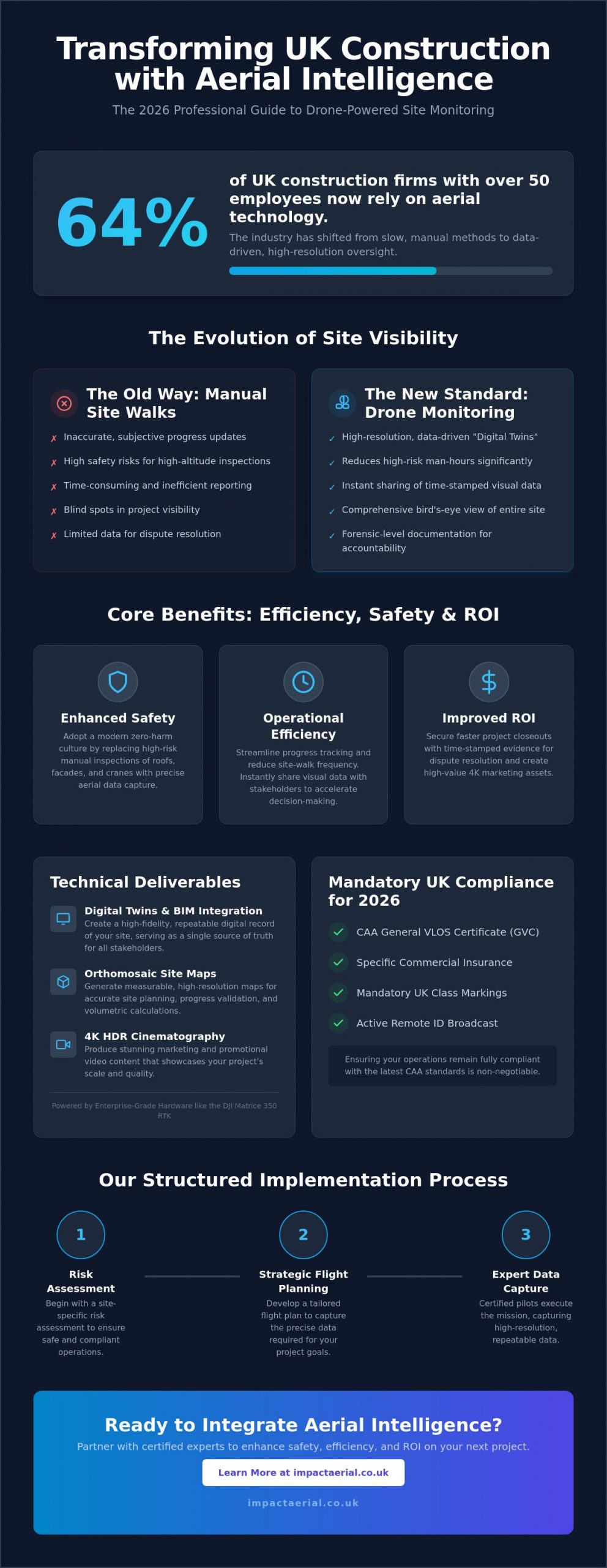
Over 40% of large enterprises are expected to use digital twins by 2027, according to MindInventory research. This represents a significant shift for UK project managers who are moving away from the limitations of inaccurate 2D drawings and the inherent risks of manual site inspections. Creating a digital twin with drone data isn’t just about capturing a 3D model; it’s about building a living, data-rich ecosystem that bridges the gap between field operations and the office. When executed with professional precision, these assets provide a level of site oversight that was previously impossible.
You likely recognize that traditional inspection methods are increasingly inefficient for complex modern structures. This guide will show you how to transform raw drone data into high-precision digital twins that drive predictive maintenance and construction efficiency. We’ll examine the technical workflows required for professional-grade output, the latest 2026 CAA compliance standards like Remote ID, and the specific hardware needed to move from basic site monitoring to a truly functional digital asset. By the end of this article, you’ll understand how to reduce site visit frequency and improve safety through remote, high-resolution monitoring.
Key Takeaways
- Master the technical workflow for creating a digital twin with drone data, transforming static sites into dynamic, living assets for real-time remote monitoring.
- Discover how to achieve centimetre-level accuracy using RTK (Real-Time Kinematic) positioning and commercial-grade enterprise hardware.
- Learn to optimize data capture using specific overlap percentages and automated flight missions to ensure comprehensive 360-degree coverage of complex structures.
- Understand how to leverage ‘as-built’ comparisons to identify construction errors early, significantly reducing the need for costly manual site inspections.
- Gain insights into maintaining strict UK regulatory compliance through CAA GVC certification and robust risk mitigation protocols.
What is a Digital Twin and How Does it Differ from 3D Modelling?
Understanding the distinction between a standard 3D model and a functional digital twin is the first step toward modernizing asset management. While a 3D model provides a visual representation of a structure at a specific point in time, a digital twin acts as a synchronized virtual replica that mirrors the state of its physical counterpart. To understand the foundational concept of What is a Digital Twin, one must view it as a ‘living asset’ that evolves alongside the real-world project.
This evolution is achieved through the continuous integration of new information. In the context of creating a digital twin with drone data, this involves performing repeat flights and integrating sensor data to ensure the digital version remains accurate. Unlike static photogrammetry, which offers a frozen snapshot, a dynamic digital twin supports ongoing lifecycle management and Building Information Modelling (BIM) integration. This is now a standard requirement for major UK construction frameworks, providing a data-rich environment for stakeholders to collaborate.
To better understand this workflow and how it applies to complex infrastructure, watch this technical overview:
The Three Pillars of a Functional Digital Twin
- Physical Asset: The tangible structure, such as a Birmingham commercial development or a regional solar farm, that requires monitoring.
- Digital Connection: The data bridge established by high-resolution imagery and LiDAR, ensuring the virtual model reflects current reality through creating a digital twin with drone data.
- Operational Insight: The ability to use the twin for predicting maintenance schedules or verifying that construction progress matches the original design specifications.
Why Drone Data is the Gold Standard for Digital Twins
Aerial platforms provide a level of detail that ground-based methods can’t match. Drones capture vertical facades and complex geometries that traditional surveying often misses, ensuring no blind spots in the digital replica. Speed is another critical factor; professional teams can reduce data collection timelines from several weeks to just a few hours. Most importantly, aerial data collection enhances safety. It eliminates the need for risky manual inspections involving scaffolding or rope access, keeping surveyors safely on the ground while the aircraft handles the high-altitude work.
Capturing High-Precision Drone Data: Hardware and Compliance
High-fidelity data acquisition starts with the right hardware. When creating a digital twin with drone data, consumer-grade equipment often lacks the sensor quality and positioning accuracy required for professional engineering standards. Commercial-grade platforms, such as the DJI Matrice 350 RTK or the Mavic 3 Enterprise, are essential. These drones provide the mechanical stability and high-resolution payloads needed to capture the sharp, undistorted imagery that forms the basis of a reliable digital asset.
Precision is governed by Real-Time Kinematic (RTK) positioning. This technology provides centimetre-level accuracy by correcting GPS data in real-time against a base station. While some surveyors still debate the use of traditional Ground Control Points (GCPs) versus RTK, professional UK workflows typically use a hybrid approach. This technical rigour ensures that the virtual model maintains a high-fidelity spatial relationship with the real world, aligning with the formal mathematical representation of a digital twin where data integrity is paramount.
Sensor Selection: Photogrammetry vs. LiDAR
- Photogrammetry: This is the most cost-effective method for visual detail. It’s excellent for high-resolution textures and general site monitoring.
- LiDAR: Essential for projects requiring penetration through dense vegetation or the capture of fine structural details like power lines and lattice towers.
- Thermal Payloads: Integrating thermal data is vital for “living” twins of energy infrastructure. This allows for specialized PV solar farm thermal surveys that identify failing cells within a wider 3D ecosystem.
UK Regulatory Framework for Drone Data Collection
Compliance is a critical component of any professional survey. In the UK, the Civil Aviation Authority (CAA) categorizes flights into Open and Specific categories. Most commercial work in urban or congested environments requires a pilot with a General Visual Line of Sight Certificate (GVC). This certification proves the operator has the competency to manage risks in complex settings.
Asset owners should also verify that their drone partner carries at least £5m in commercial liability insurance. This level of coverage, combined with meticulous flight planning, provides the necessary reassurance when creating a digital twin with drone data on active construction sites or high-value commercial properties. Professional risk mitigation ensures that data collection is not only accurate but also fully legal and safe.
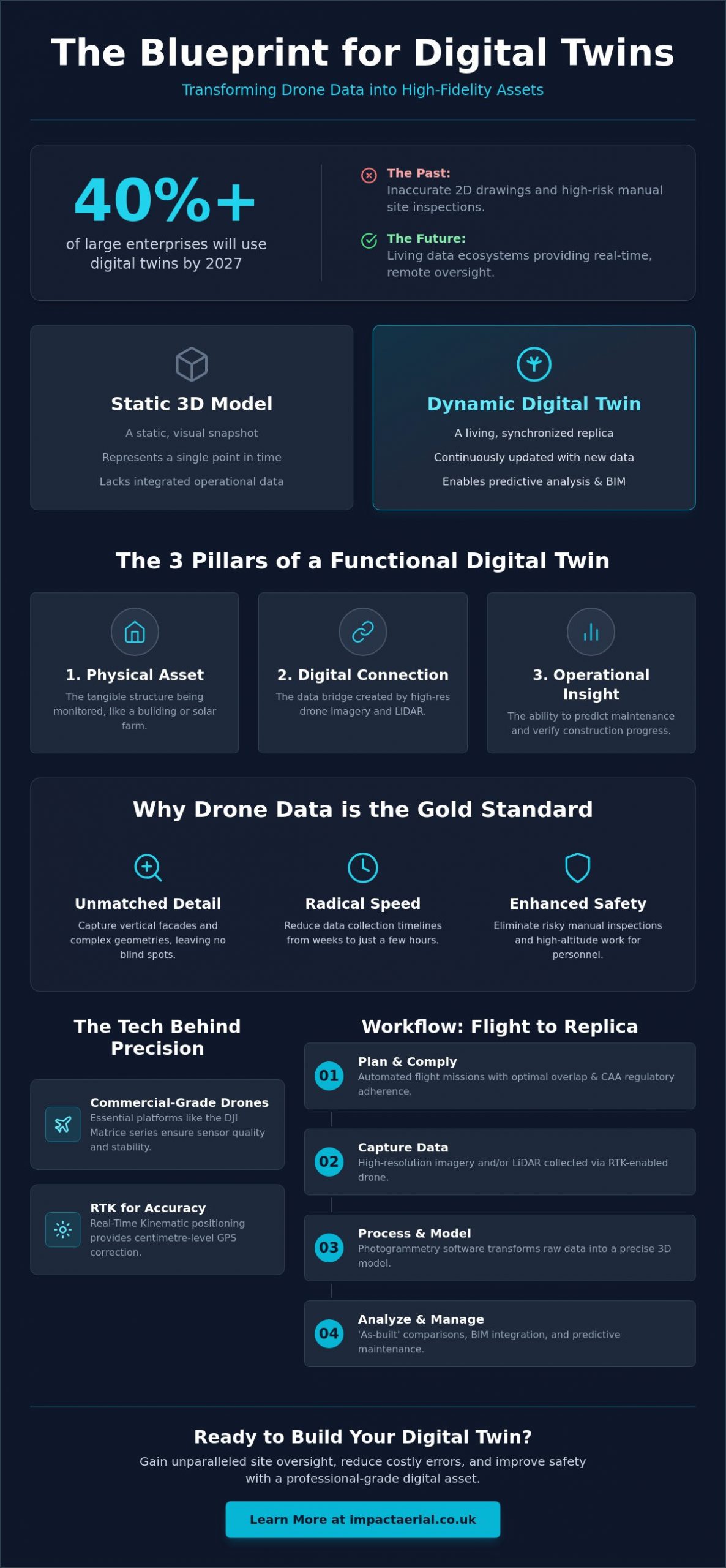
The Step-by-Step Workflow: From Flight to 3D Replica
The transition from a physical structure to a high-fidelity digital replica is a structured process that demands technical precision at every stage. It begins with meticulous flight planning. To ensure the software can accurately calculate depth and geometry, we typically set a front overlap of 80% and a side overlap of 70%. For creating a digital twin with drone data of vertical structures, such as commercial facades or bridges, camera angles must be adjusted from standard nadir (top-down) views to oblique perspectives. This ensures that every vertical surface is captured with the same detail as the roofline.
Data capture is rarely a manual affair. Professional pilots execute automated grid missions for site-wide mapping and ‘orbit’ missions for individual assets. These pre-programmed flight paths ensure 360-degree coverage and eliminate the risk of missing critical data points. Once the flight is complete, the imagery is moved into a high-performance processing environment. Here, photogrammetry software stitches thousands of images together to form a dense point cloud. This point cloud is later converted into a 3D mesh and textured with high-resolution imagery to create a model ready for stakeholder review.
Beyond digital visualization, these 3D meshes can also be used for rapid prototyping. Specialist studios like Protomolecule can utilize the exported data to create high-precision 3D printed models, providing a tangible way to inspect complex structural geometries or present project site plans to stakeholders.
Optimising Data for Accuracy
Capturing images is only half the battle. Professional standards require consistent exposure and sharp focus across the entire dataset. Inconsistent lighting can lead to ‘ghosting’ or alignment errors during processing. We also focus heavily on filtering ‘noise’ from the point clouds. This involves removing temporary objects like moving vehicles or swaying vegetation that can distort structural lines. Finally, georeferencing ensures the model aligns perfectly with real-world coordinates, which is essential for any project requiring centimetre-level spatial integrity.
Software Platforms and Integration
A digital twin’s value lies in its utility. At Impact Aerial, we use industry-standard processing suites that allow for seamless integration into existing workflows. The data isn’t just a visual aid; it’s a functional tool that can be exported directly into CAD or Revit for engineering analysis. When creating a digital twin with drone data, we prioritize cross-device accessibility. This allows site teams in the field and remote stakeholders in the office to interact with the same ‘living’ asset in real-time, ensuring everyone is working from a single, accurate version of the truth. If you need a custom web platform to host and visualize these assets, you can check out Larasoft for bespoke software development.
Industry Applications: Where Digital Twins Drive ROI in 2026
The financial case for creating a digital twin with drone data is built on the mitigation of risk and the acceleration of project timelines. In the UK construction sector, “as-built” models are now routinely compared against “as-designed” BIM plans. This allows project managers to identify structural deviations or installation errors in real-time, preventing expensive remedial work later in the build cycle. By catching these discrepancies early, developers can avoid the compounding costs associated with delayed schedules and material waste.
In the West Midlands, regional infrastructure projects like motorway expansions and rail improvements benefit from regular drone data updates. These updates provide a chronological record of progress that ground teams can’t capture as efficiently. For the UK’s heritage sector, high-fidelity replicas of Grade I and II listed buildings are becoming essential for conservation. These twins allow architects to study delicate facades or inaccessible roof sections without the need for intrusive scaffolding, ensuring that restoration plans are based on precise, non-destructive data.
Predictive Maintenance and Asset Longevity
Digital twins move maintenance from a reactive model to a predictive one. By using historical data captured over several months or years, asset owners can track structural decay, masonry erosion, or corrosion over time. Integrating thermal payloads into the twin allows for the detection of moisture ingress or electrical hot spots that are invisible to the naked eye. This data-driven approach significantly reduces the “Total Cost of Ownership” by enabling targeted repairs rather than full-scale replacements, extending the life of the asset while ensuring occupant safety.
Stakeholder Collaboration and Communication
Complex projects involve multiple stakeholders who often need to review site conditions from remote locations. A digital twin provides an immersive 3D environment that’s perfect for board-level presentations or planning meetings with local authorities. These models also serve as powerful communication tools; virtual tours allow international investors to explore property assets with incredible detail without leaving their offices. For those looking to integrate these assets into a broader engagement strategy, our 3D Virtual Tours for Property guide explores these immersive techniques further.
If you’re ready to improve your project oversight and data accuracy, our specialists offer professional construction site monitoring services tailored to your specific site requirements.
Why Impact Aerial is Your Partner for Digital Twin Excellence
Impact Aerial provides a specialized approach to creating a digital twin with drone data, combining technical expertise with operational rigour. Based in Birmingham, our team is strategically positioned to deploy rapidly to sites across the UK, ensuring that your project data is captured during optimal weather windows. We don’t just provide imagery; we deliver a complete end-to-end service that begins with an in-depth technical consultation and concludes with advanced post-production. This methodical flow ensures that the final digital asset is fully optimized for your specific engineering or construction requirements.
Our operations are built on a foundation of safety and compliance. We hold full CAA GVC certification, which is the professional standard for operating in complex UK environments. To provide our clients with total peace of mind, we carry £5m in commercial liability insurance. This level of protection is essential for high-value assets and active construction zones. By utilizing the latest DJI Enterprise hardware, we set a benchmark for data precision that ensures every virtual model is a high-fidelity reflection of the physical asset, providing the reliability that technical consultants demand.
The Impact Aerial Difference: Precision and Safety
Our meticulous data collection protocols often exceed the standard drone survey requirements. We stay current with the evolving UK regulatory landscape, including the January 2026 mandates for Remote ID and UK class marks. This commitment to officialdom means your data is collected legally and ethically, protecting you from the regulatory risks associated with uncertified operators. Our expert post-production team then processes this raw information, turning it into actionable business intelligence that supports your specific lifecycle management goals and long-term asset monitoring.
Get Started with Your Digital Transformation
Every project has unique Key Performance Indicators (KPIs). We tailor our approach to creating a digital twin with drone data based on whether you require centimetre-level topographical accuracy or high-resolution thermal analysis for energy efficiency. Our onboarding process is structured to be seamless and informative. It starts with a comprehensive site risk assessment and flight planning phase, moving through to precision execution and final data delivery through your preferred software environment, such as Revit or CAD.
Request a professional drone data consultation from Impact Aerial today to learn how our technical consultants can help you reduce site visit frequency, improve safety, and enhance your overall operational efficiency through high-precision aerial data.
Advancing Your Digital Asset Strategy
Transitioning from static 3D models to dynamic, living replicas is a critical step for modern asset management. By creating a digital twin with drone data, you gain a high-fidelity environment that supports predictive maintenance and improves stakeholder communication across the project lifecycle. This shift doesn’t just enhance oversight; it fundamentally changes how you interact with your physical assets, moving from reactive repairs to data-driven operational decisions.
Professional execution is the only way to ensure these digital assets meet the rigorous standards required for UK construction and infrastructure. At Impact Aerial, we combine advanced DJI Enterprise hardware with meticulous data protocols to deliver centimetre-level accuracy. Our team provides the security you need through CAA GVC certified pilots and £5m in commercial liability insurance, ensuring every flight is compliant and every dataset is precise.
Your digital transformation starts with a specialized partner who understands both the technology and the regulatory landscape. Book Your Professional Drone Survey Consultation today to explore how we can integrate high-precision aerial data into your existing workflows. We look forward to helping you build a safer, more efficient future for your property portfolio.
Frequently Asked Questions
What is the difference between photogrammetry and a digital twin?
Photogrammetry is the specific technology used to extract 3D information from 2D photographs, while a digital twin is the comprehensive virtual replica itself. While photogrammetry provides a static visual model at a single point in time, a digital twin integrates ongoing data to reflect the current state of a physical asset. This distinction is vital for lifecycle management, as the digital twin serves as a functional tool for long-term monitoring rather than just a one-off visual record.
How accurate is drone data for creating 3D digital twins?
Professional-grade hardware equipped with Real-Time Kinematic (RTK) positioning achieves centimetre-level accuracy in the virtual model. This precision ensures that the twin aligns perfectly with real-world coordinates, which is essential for engineering and construction applications. Creating a digital twin with drone data at this level of fidelity allows for reliable comparisons between as-built structures and original design plans, providing the technical rigour required for high-stakes infrastructure projects.
Do I need a special UK drone license to create digital twins for my business?
Commercial operators typically require a General Visual Line of Sight Certificate (GVC) from the Civil Aviation Authority (CAA) for work in urban environments. While low-risk flights might fall under the Open category, most professional business applications involving digital twins require Specific category authorization. This ensures the pilot has undergone formal training in risk mitigation and flight safety, which is a legal prerequisite for operating drones commercially in congested UK areas.
What is the typical ROI for implementing drone digital twins in construction?
The primary return on investment comes from identifying construction errors early and reducing the need for manual site visits. By catching structural deviations before they become compounded issues, developers avoid expensive remedial work and project delays. Additionally, the ability to perform remote inspections significantly lowers the risk of on-site accidents and reduces the overhead costs associated with traditional surveying methods like scaffolding or high-access platforms.
Can drone digital twins be integrated with existing BIM software?
Professional drone data is fully compatible with industry-standard Building Information Modelling (BIM) software such as Revit and AutoCAD. The processed point clouds and 3D meshes can be exported in various formats, allowing for seamless integration into existing digital workflows. This allows project managers to overlay aerial data directly onto design plans, facilitating a more collaborative and accurate environment for architects, engineers, and site stakeholders to review progress in real-time.
How often should drone data be updated for a ‘living’ digital twin?
Update frequency depends entirely on the project’s pace and the specific goals of the asset owner. For active construction sites, weekly or bi-weekly flights are often necessary to track rapid progress and verify milestones. For long-term asset management of established buildings, quarterly or bi-annual updates might be sufficient. The “living” nature of the twin is maintained by ensuring that new data is captured whenever a significant physical change occurs to the asset.
What hardware is required for high-resolution digital twin capture?
High-resolution capture requires enterprise-grade drones such as the DJI Matrice 350 RTK or the Mavic 3 Enterprise. These platforms support high-megapixel sensors and specialized payloads, such as the Zenmuse P1 for photogrammetry or LiDAR sensors. Creating a digital twin with drone data at professional standards also necessitates robust processing hardware or cloud-based platforms capable of handling the massive datasets generated by thousands of high-resolution images across a single site.
Is it safer to use drones for digital twin creation than traditional methods?
Drones are significantly safer than traditional surveying methods because they eliminate the need for personnel to work at height. Manual inspections often involve scaffolding, rope access, or fragile roof walks, all of which carry inherent risks to life and limb. Aerial data collection allows surveyors to remain safely on the ground while the aircraft captures data from hazardous or inaccessible locations. This reduction in physical risk is a primary driver for drone adoption in the UK industrial sector.