Drone Survey for Coastal Erosion Monitoring: A Professional Guide for 2026

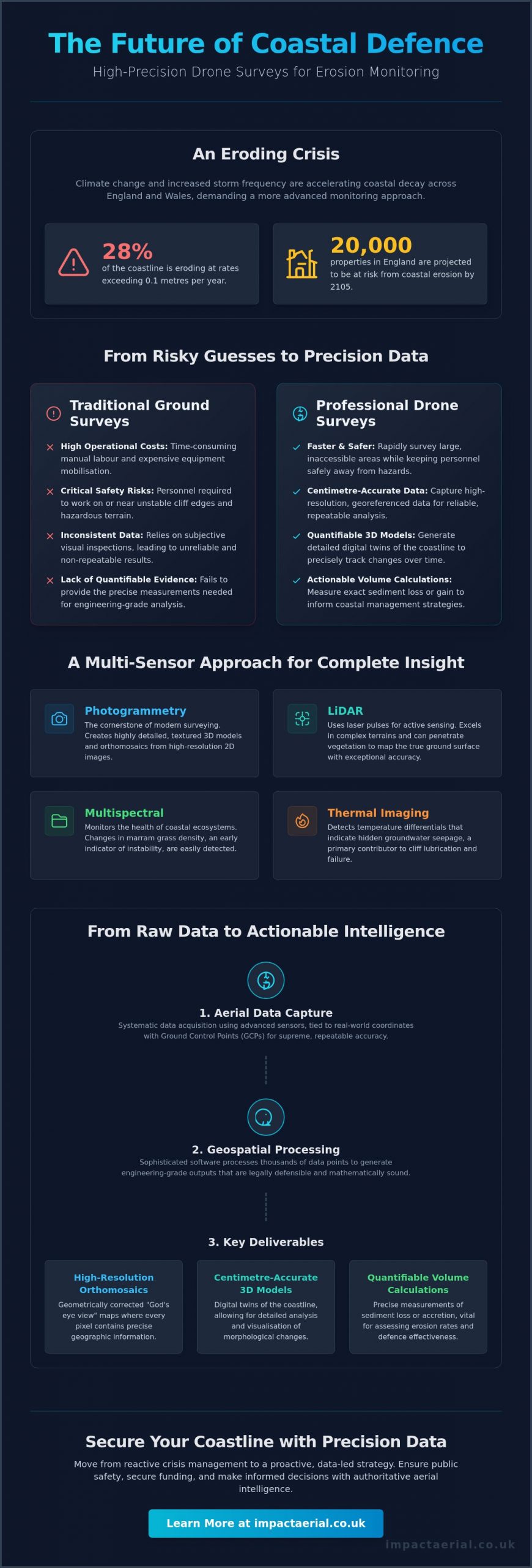
With 28% of the coastline across England and Wales eroding at rates exceeding 0.1 metres per year, can your current monitoring strategy provide the precision required for 2026? You’re likely familiar with the logistical strain of traditional ground-based surveys, including high operational costs and the genuine health and safety risks of surveying unstable cliff edges. Relying on inconsistent visual inspections instead of a professional drone survey for coastal erosion monitoring often leaves you without the quantifiable data needed for critical coastal management.

Discover how high-precision drone data is revolutionising the industry, offering faster, safer, and more accurate erosion monitoring than traditional methods. By leveraging advanced sensors, you can now generate high-resolution 3D models and quantifiable volume calculations of sediment loss with absolute confidence. This guide details the essential technical standards, from LiDAR capabilities to the latest UK drone classifications, ensuring your operations remain both compliant and authoritative in a shifting landscape.

Key Takeaways

  • Learn how to select between LiDAR and Photogrammetry sensors to capture the most accurate geospatial data across diverse shoreline terrains.
  • Understand the operational advantages of a professional drone survey for coastal erosion monitoring, specifically how it mitigates safety risks on unstable cliff edges.
  • Discover the essential planning phases for a successful monitoring programme, including the critical synchronisation of flights with local tide times and weather windows.
  • Navigate the complexities of UK regulatory compliance by understanding the requirements for CAA GVC certification and operating within restricted environmental zones.
  • Identify how to translate high-precision aerial data into quantifiable 3D models and sediment volume calculations to support long-term coastal management strategies.

Understanding Drone Surveys for Coastal Erosion Monitoring

Coastal monitoring via Unmanned Aerial Vehicles (UAVs) involves the systematic acquisition of high-resolution geospatial data to track changes in shoreline morphology. This methodology replaces traditional, subjective visual assessments with measurable, repeatable evidence. With approximately 28% of the coast in England and Wales experiencing coastal erosion at rates higher than 0.1 metres per year, the demand for high-frequency data has never been more urgent. Modern environmental management requires a level of precision that only aerial technology can provide at scale.

Stakeholders ranging from local councils in Norfolk and East Riding to private developers are facing unprecedented challenges. Climate change and increased storm frequency have accelerated the rate of UK coastal decay, putting an estimated 20,000 properties in England at risk by 2105. A professional drone survey for coastal erosion monitoring provides the technical depth required to manage these risks. It moves the conversation from reactive crisis management to proactive, data-led strategy, allowing for more efficient allocation of resources and public safety measures.

To better understand the practical application of these systems in the field, watch this demonstration of high-precision hardware in a coastal environment:

The Role of Aerial Data in Risk Mitigation

Meticulous data capture allows specialists to identify structural anomalies, such as tension cracks, long before they lead to cliff failure. By detecting these shifts early, authorities can implement exclusion zones or reinforcement measures with higher confidence. This aerial intelligence serves as critical evidence when local authorities apply for coastal defence funding or when developers submit planning applications for vulnerable sites. Establishing a robust baseline is the first step. Without historical data to compare against, it’s impossible to calculate the true rate of decay or the effectiveness of existing defences.

Visual Imagery vs. Geospatial Data

There is a significant distinction between simple aerial photography and geospatial intelligence. While 4K video is excellent for reporting, it doesn’t offer the centimetre-accurate 3D mapping required for engineering-grade analysis. A professional drone survey for coastal erosion monitoring utilises orthomosaics, which are geometrically corrected aerial images. These provide a “God’s eye view” where every pixel contains geographic information. To ensure this data remains reliable in complex maritime environments, we utilise Ground Control Points (GCPs). These physical markers on the ground tie the aerial data to real-world coordinates, ensuring that year-on-year comparisons are mathematically sound and legally defensible.

Sensor Technology: LiDAR, Photogrammetry, and Multispectral

Precision in coastal monitoring depends entirely on the chosen sensor payload. While visual inspections provide a surface-level narrative, a professional drone survey for coastal erosion monitoring utilises a suite of advanced sensors to capture specific environmental variables that the human eye cannot detect. These technologies allow us to move beyond simple photography into the realm of quantifiable geospatial intelligence. By selecting the correct sensor, we can identify the underlying causes of instability, such as hidden groundwater seepage or shifting vegetation patterns, with absolute technical certainty.

Photogrammetry remains the cornerstone of modern surveying, using high-resolution 2D images to reconstruct 3D environments. However, for more complex terrains, LiDAR (Light Detection and Ranging) offers an active sensing solution that measures distances using laser pulses. We also deploy multispectral sensors to monitor the health of coastal ecosystems, as changes in marram grass density often precede physical sand loss. Thermal imaging adds another layer of risk mitigation; it detects temperature differentials that indicate groundwater seepage, a primary contributor to cliff lubrication and subsequent failure.

When to Choose LiDAR for Coastal Surveys

LiDAR is the gold standard for surveying “soft” cliffs where heavy vegetation or marram grass obscures the soil. Unlike traditional cameras, LiDAR’s unique ability to ‘see through’ foliage allows for the creation of accurate Digital Terrain Models (DTMs) by filtering out vegetation to reach the true ground surface. This capability is essential for coastal mapping with drones in areas where obscured slopes might hide significant structural risks. It’s particularly effective in low-light conditions or high-contrast environments where shadows might confuse standard photogrammetry software.

The Power of Photogrammetry for 3D Modelling

Photogrammetry excels in generating high-detail “Digital Twins” of coastal infrastructure, such as sea walls, groynes, and piers. It’s an exceptionally cost-effective method for conducting regular beach volume checks, providing the high-resolution texture maps needed to identify fine-line cracks in masonry or concrete defences. The resulting data integrates seamlessly into Geographic Information Systems (GIS), allowing local authorities to perform long-term sediment tracking and volumetric analysis. If you’re managing a complex site and need to determine which sensor will yield the most actionable data, our specialists can guide you through our professional drone commercial property surveys and environmental monitoring options.

By combining these sensor outputs, we create a comprehensive data set that serves as a legal and technical baseline for all future coastal management decisions. Whether you’re tracking millimetre-scale shifts in a cliff face or calculating the loss of thousands of cubic metres of sand after a winter storm, the right sensor technology ensures your data is both accurate and defensible.

Drone Survey for Coastal Erosion Monitoring: A Professional Guide for 2026

Drone vs. Traditional Coastal Surveying Methods

Traditional coastal surveying often requires personnel to manually traverse intertidal zones and cliff tops with GNSS poles. This legacy approach is inherently slow; it often takes several days to cover a stretch of coastline that a professional drone can map in a few hours. By transitioning to a drone survey for coastal erosion monitoring, you’re not just increasing speed but fundamentally changing the depth of your data. While manual methods rely on sparse transects every 50 to 200 metres, aerial platforms capture millions of data points across the entire surface, leaving no gaps in your environmental record.

Safety remains a primary driver for adopting UAV technology. Traditional methods frequently put surveyors at risk, requiring them to access unstable cliff edges or navigate dangerous tidal flats. Aerial surveys remove the need for physical access to these hazardous areas entirely. Additionally, drones offer a zero-footprint solution. This is particularly vital for Sites of Special Scientific Interest (SSSIs) where foot traffic or heavy equipment might disturb sensitive habitats. Research into USGS remote sensing technologies confirms that these non-invasive methods provide superior data without the ecological cost of ground-based operations.

Cost-Benefit Analysis for Local Authorities

Local authorities often find that drones significantly reduce the logistical overhead associated with sea vessels or crewed aircraft. While RICS notes that traditional surveys are typically conducted every six months to two years, the cost-efficiency of drones allows for “event-based” monitoring. This means you can deploy a team immediately after a major storm to assess damage in real time. This proactive approach offers a far higher long-term ROI; early detection of structural weaknesses in sea defences can prevent catastrophic infrastructure loss and the multi-million pound repair bills that follow.

Accuracy and Precision Standards

A common misconception is that aerial data is less precise than ground-based measurements. Modern RTK (Real-Time Kinematic) drones achieve sub-5cm absolute accuracy, providing engineering-grade data that rivals any traditional method. We provide 1cm-per-pixel resolution, allowing for the detection of hairline fractures in sea walls that would be invisible on a standard 200-metre transect. For a more comprehensive look at how we maintain these standards, read our Drone Survey: The Complete Guide to Aerial Data Collection. This precision ensures that your coastal management decisions are based on the most rigorous data available in 2026.

Implementing a Coastal Erosion Monitoring Programme

Executing a structured drone survey for coastal erosion monitoring requires meticulous planning across five distinct phases. Phase 1 begins with defining the Area of Interest (AOI) and determining the required Ground Sample Distance (GSD); higher resolution is typically needed for cliff face crack detection than for general beach volume checks. Phase 2 involves rigorous pre-flight planning. In the UK, this means synchronising flight windows with low tide times to ensure maximum beach exposure and monitoring weather patterns to stay within safe wind speed tolerances.

Phase 3 is the operational stage, where we deploy high-tier DJI Enterprise hardware, such as the Matrice 350 RTK, to capture data with centimetre-level positioning accuracy. Once the flight is complete, Phase 4 moves into post-processing. Here, we use photogrammetry software to transform thousands of raw images into georeferenced point clouds and orthomosaics. Finally, Phase 5 delivers reporting and actionable insights, providing local authorities with the evidence needed for immediate safety interventions or long-term defence planning.

Analysing Volume and Elevation Changes

We use specialized ‘swipe’ tools to overlay orthomosaics from different years, allowing for a direct visual comparison of shoreline retreat. This process quantifies sediment movement with high precision, answering exactly how many cubic metres of sand were lost during the last winter season. Digital Elevation Models (DEMs) provide a colour-coded representation of height data that makes even millimetre-scale terrain shifts visually apparent for analysis.

AI and Automated Change Detection

Modern monitoring programmes now integrate machine learning to automatically flag areas where erosion exceeds pre-defined thresholds. These algorithms track the retreat of the ‘cliff toe’ over multiple survey cycles, providing an objective metric of decay. Standardising this data ensures it’s compatible with multi-agency databases, such as those maintained by the Environment Agency and RICS. If you require a robust, compliant framework for your site, our team provides expert construction site monitoring and environmental data services to ensure long-term stability.

UK Compliance: Why Professional Certification Matters

Operating a professional drone survey for coastal erosion monitoring in the UK requires more than just technical skill; it demands strict adherence to Civil Aviation Authority (CAA) regulations. In 2026, the legal framework has become more defined, with all new drones requiring UK-specific class marks from UK0 to UK6. For complex commercial missions near sensitive shorelines, holding a General Visual Line of Sight (GVC) certificate is the standard requirement. This certification demonstrates a pilot’s competence in managing risk and navigating the specific operational challenges of maritime environments.

Navigating the geography of the coast often involves flying within Flight Restriction Zones (FRZs) near regional airports or military installations. Furthermore, many eroding cliffs are designated as Sites of Special Scientific Interest (SSSIs). Conducting surveys in these areas requires specific permissions from Natural England to ensure that aerial operations don’t disturb protected wildlife. To mitigate these risks, £5m commercial liability insurance has become the industry standard. This level of coverage provides the necessary reassurance to local councils and private developers that they’re partnering with a compliant and safety-conscious operator.

Safety Protocols in Maritime Environments

Coastal environments present unique technical hurdles that differ significantly from inland surveys. High winds and corrosive salt spray can impact hardware performance, requiring pilots to use aircraft with high IP ratings and robust wind resistance. Public safety is another critical pillar of our protocol. Because coastal paths and beaches are often public spaces, we implement strict ground-control measures to manage access during flight windows. Understanding these rules is vital for any stakeholder; you can learn more about the current regulatory landscape in our guide to the UK Drone License: A Simple Guide to CAA Rules in 2026.

The Impact Aerial Standard

Impact Aerial maintains a meticulous approach to data-centric processes and regulatory officialdom. We don’t just fly; we provide a technical consultancy service that prioritises precision and legal compliance. While our operations are often based out of Birmingham, we provide nationwide coverage, bringing specialist expertise to every corner of the UK coastline. We’re proud of our professional affiliations and our ability to deliver high-tier geospatial output that stands up to the most rigorous engineering scrutiny. If you’re ready to transition from inconsistent visual inspections to a georeferenced monitoring programme, contact Impact Aerial for a professional coastal survey consultation to discuss your project’s specific requirements.

Securing the Future of Coastal Management with Geospatial Intelligence

The transition from manual inspections to high-precision aerial data is a fundamental shift in how we protect vulnerable shorelines. By integrating advanced LiDAR and photogrammetry, you gain access to quantifiable volume calculations and centimetre-accurate 3D models that traditional methods cannot match. This data-centric approach ensures that every management decision is backed by rigorous technical evidence rather than visual estimation. A professional drone survey for coastal erosion monitoring provides the necessary baseline for tracking long-term shifts in shoreline morphology with absolute technical certainty.

Impact Aerial stands as a trusted specialist in this expanding market. Our operations are led by CAA GVC Certified Pilots who utilise high-tier DJI Enterprise hardware to deliver industry-leading results. With £5m commercial liability insurance and a meticulous focus on UK regulatory compliance, we provide the reassurance and tangible data your project requires. Request a Professional Drone Survey Quote from Impact Aerial to begin your monitoring programme. We’re ready to help you navigate the complexities of environmental management with precision and confidence.

Frequently Asked Questions

How accurate are drone surveys for monitoring coastal erosion?

Drone surveys provide engineering-grade accuracy, typically achieving sub-5cm absolute accuracy when using RTK-enabled hardware. This level of precision allows for the detection of minute structural shifts and hairline fractures in sea defences. By integrating Ground Control Points (GCPs), we ensure that every dataset is georeferenced to national grid standards, providing a reliable baseline for year-on-year comparisons.

Can drones fly in high winds common on the UK coast?

Professional Enterprise drones are designed to operate in challenging coastal conditions, with many models offering wind resistance up to 12 or 15 metres per second. However, safety remains our primary concern. We monitor real-time anemometer data during every mission to ensure the aircraft remains within its technical tolerances. If wind speeds exceed safe limits or gust unpredictably, we suspend operations to protect the equipment and the public.

Do I need special permission to survey a SSSI coastal area?

Yes, conducting a drone survey for coastal erosion monitoring within a Site of Special Scientific Interest (SSSI) requires formal consent from Natural England. These areas are ecologically sensitive, and drone flight can potentially disturb nesting birds or rare habitats. As part of our meticulous planning process, we handle these regulatory applications to ensure all operations are fully compliant with environmental protection laws.

What is the difference between LiDAR and Photogrammetry for beach surveys?

The primary difference lies in how data is captured. Photogrammetry reconstructs 3D models from high-resolution 2D images, making it ideal for open beaches and masonry structures. LiDAR uses active laser pulses that can penetrate dense vegetation or marram grass to map the true ground surface. While photogrammetry is often more cost-effective for clear terrain, LiDAR is essential for “soft” cliffs with heavy foliage.

How often should coastal erosion surveys be conducted?

We recommend conducting surveys at least twice a year to capture seasonal sediment shifts. Ideally, these should occur in spring and autumn to track the impact of winter storms. However, “event-based” monitoring is also critical. Deploying a drone immediately after a major storm surge provides invaluable data on immediate volume loss, allowing local authorities to assess the integrity of coastal defences before further damage occurs.

What data formats are provided after a drone coastal survey?

Our post-production services deliver data in industry-standard formats compatible with most GIS and CAD software. Common outputs include georeferenced orthomosaics (.GeoTIFF), high-density point clouds (.LAS or .LAZ), and 3D mesh models (.OBJ). We also provide Digital Elevation Models (DEMs) and Digital Terrain Models (DTMs), which are essential for conducting volumetric analysis and sediment tracking across multiple survey cycles.

Is a drone survey cheaper than a traditional land survey?

A professional drone survey for coastal erosion monitoring is significantly more cost-effective for large-scale projects, often reducing expenses by 50% to 75% compared to traditional ground-based methods. The primary savings come from reduced logistical overhead and faster data collection speeds. While a ground team might take days to traverse a kilometre of unstable cliff, a drone can map the same area in under an hour.

How do drones help in calculating volume loss on cliffs?

Drones enable precise volumetric calculations by comparing 3D point clouds or Digital Elevation Models from different time periods. By “subtracting” a newer survey from an older baseline, software can calculate the exact volume of material lost in cubic metres. This allows engineers to quantify the rate of cliff retreat and identify specific areas where the “cliff toe” is becoming undercut, which is a primary indicator of imminent failure.

What Does a Drone Survey Report Include? A 2026 Professional Guide

If you received 500 high-resolution aerial photos but couldn’t use a single one to prove a structural defect to your insurer, was it really a survey? Many property managers and construction leads have felt the frustration of being handed a folder of raw images without the technical context needed to make a commercial decision. It’s common to feel uncertain about whether your data meets professional standards or if it’s just a collection of nice pictures. Understanding what does a drone survey report include is the first step toward moving from simple photography to actionable geospatial data.

You deserve a report that provides clarity rather than adding to the technical jargon. We’ve designed this 2026 guide to reveal the specific maps, data sets, and insights that transform aerial footage into a professional survey. We’ll explore the essential components of a CAA-compliant report, including orthomosaic maps, digital elevation models, and the rigorous technical documentation required for insurance validity. By the end, you’ll have the confidence to commission a survey that delivers tangible results and precise data for your next commercial property or construction project.

Key Takeaways

  • Understand why a professional deliverable is a structured geospatial asset rather than a collection of photos, and learn exactly what does a drone survey report include to meet 2026 industry standards.
  • Gain insight into the technical applications of 3D Point Clouds and Digital Twins for conducting precise structural measurements and long-term asset management.
  • Learn to use standardised defect scoring to categorise maintenance issues by urgency, streamlining your decision-making process and resource allocation.
  • Discover the critical role of CAA regulatory compliance in ensuring your aerial data serves as legally valid proof of condition for insurance purposes.
  • Explore how bespoke reporting tailored to specific sectors, such as PV solar farms and construction sites, provides the precise data required for sector-specific compliance.

Understanding the Modern Drone Survey Report in 2026

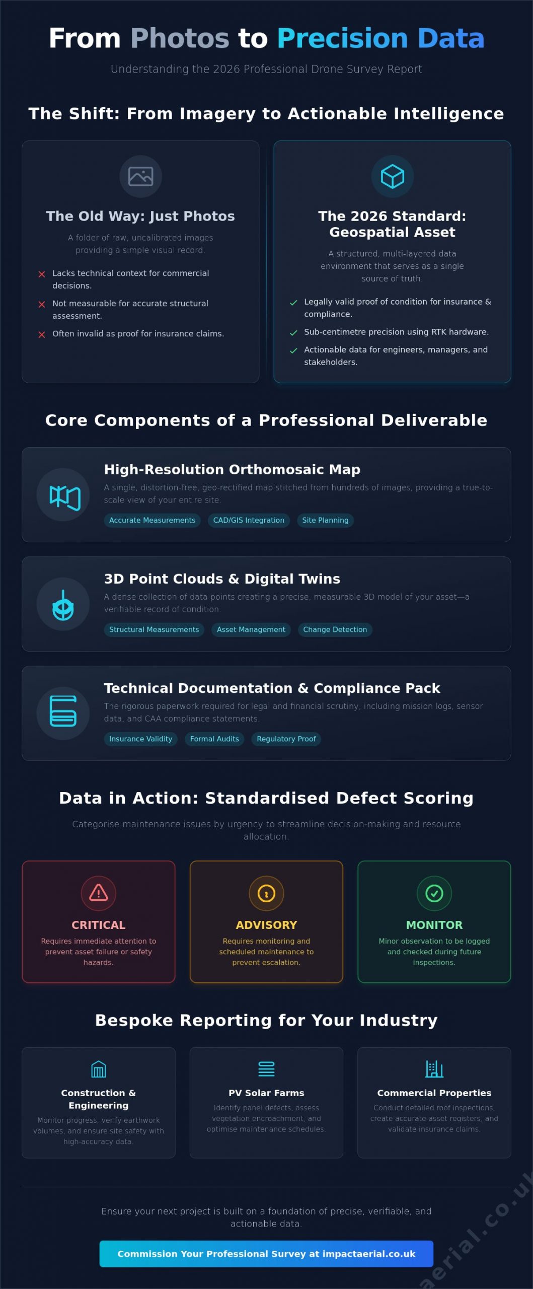
A professional drone survey report is far more than a digital gallery of high-altitude pictures. In 2026, it represents a comprehensive geospatial asset that serves as a single source of truth for property managers and engineers alike. If you are questioning what does a drone survey report include, the answer lies in the transition from simple aerial photography to high-accuracy photogrammetry. This process converts hundreds of individual images into a unified, measurable data set that can be used for legal, financial, and structural assessments.

Technological advancements in 2026 have pushed accuracy levels to sub-centimetre precision. By utilizing RTK (Real-Time Kinematic) hardware and unified processing software like PIX4Dmatic, surveyors now deliver outputs that align perfectly with national grid coordinates. This level of detail ensures that every pixel carries geographical weight, making the report a valid document for insurance claims and regulatory compliance.

To see how these measurements translate into professional reporting, watch this demonstration:

From Visual Imagery to Geospatial Data

Modern drones capture images with high overlap, allowing sophisticated algorithms to reconstruct the environment in three dimensions. This is the core of Aerial Survey Methods. There is a fundamental difference between looking at a roof and actually measuring a structure. A visual inspection might show a crack, but a geospatial report identifies its exact length, width, and depth within a global coordinate system. Every data point is timestamped. This creates a rigorous audit trail that is indispensable for construction site monitoring or solar farm maintenance. It ensures that the information you receive isn’t just a snapshot, but a verifiable record of condition.

Why a Standard PDF Isn’t Enough

A standard PDF summary is useful for a quick executive overview, but it shouldn’t be the only deliverable. High-tier reports include interactive digital layers that allow technical engineers to manipulate the data. While a manager might only need to see the risk categorisation of a defect, an engineer requires the raw, high-resolution point clouds to plan repairs. Professional reporting caters to both audiences by providing a clear summary backed by terabytes of verifiable data. This ensures that the insights you receive are actionable and can withstand the scrutiny of a formal audit or an insurance loss adjuster. When you understand what does a drone survey report include at this level, you can better appreciate the value of data-centric workflows over simple photography.

The Core Components of a Professional Survey Deliverable

A professional deliverable is a multi-layered data environment. While basic services might offer a few high-definition photos, a commercial-grade output integrates several distinct data formats. When considering what does a drone survey report include, you should look for a combination of visual, spatial, and thermal data that provides a holistic view of the asset. This structured approach mirrors the standards seen in the EPA drone usage and compliance report, where rigorous sensor documentation and mission logging are paramount for official record-keeping.

High-Resolution Orthomosaic Mapping

An orthomosaic is a distortion-free, geo-rectified map created by stitching together hundreds of individual aerial images. Unlike a standard photograph, every point on an orthomosaic is a true representation of the ground surface. This allows for accurate site-wide measurements. These maps are essential for planning and can be imported directly into CAD or GIS software. This seamless integration ensures that your survey data flows directly into your existing project management workflows without manual translation.

3D Point Clouds and Digital Twin Models

For construction and large-scale property management, 3D point clouds are invaluable. These models consist of millions of individual data points, each with its own X, Y, and Z coordinate. This allows engineers to perform volumetric calculations for stockpiles or conduct elevation checks across a site without setting foot on the ground. Digital twins provide a virtual site visit capability, letting stakeholders inspect a structure from any location. If you require this level of precision for your project, you might consider our drone commercial property surveys to get started.

Thermal Imaging and Anomaly Detection

Thermal layers add an invisible dimension to the report. By capturing radiometric data, we can identify heat loss, moisture ingress under flat roofs, or failing cells in PV solar farms. These anomalies are presented as detailed defect logs, featuring high-resolution crops and precise GPS coordinates. This ensures that maintenance teams can locate and repair issues with surgical accuracy. They won’t need to search across a vast site. A professional report ensures these thermal insights are overlaid on visual maps to provide the necessary context for immediate action. By combining these layers, the report becomes a tool for proactive asset management rather than just a historical record.

What Does a Drone Survey Report Include? A 2026 Professional Guide

Defect Analysis and Risk Categorisation Frameworks

Raw data provides the foundation, but professional interpretation provides the value. A report that merely lists observations without assessing their impact is incomplete. When facility managers ask what does a drone survey report include, the most critical component for their workflow is a standardised risk categorisation framework. This analytical layer ensures that every stakeholder, from the site foreman to the financial director, understands the urgency of every identified issue. Without this hierarchy, a survey is simply a collection of observations rather than a strategic maintenance tool.

A meticulous approach to defect analysis removes subjectivity from the process. Instead of vague descriptions, professional reports use precise technical language to describe structural anomalies. This level of detail is essential for maintaining a rigorous audit trail and ensuring that repair budgets are allocated where they are most needed. By categorising findings, we provide a clear roadmap for asset management that balances immediate safety concerns with long-term preventative care.

The Traffic Light System for Building Maintenance

We utilise a clear, three-tier traffic light system to communicate risk levels instantly. This methodology allows for rapid decision-making without requiring the reader to parse through technical data for every minor finding. The categories are defined as follows:

  • Red (Critical): These findings require immediate action. They represent active leaks, significant structural compromises, or immediate safety hazards that could lead to further damage or legal liability.
  • Amber (Monitor): These defects show signs of deterioration that don’t yet pose a critical risk. They are scheduled for upcoming maintenance cycles or monitored closely to prevent them from escalating into Red-tier issues.
  • Green (Maintenance): These areas are in good condition. They are documented to provide a baseline for future surveys, ensuring that routine maintenance can be tracked over time.

Geotagged Annotations and High-Resolution Crops

Precision is the hallmark of a professional survey. Every defect identified in the report is linked to its exact GPS coordinate through geotagged annotations. This eliminates the guesswork often associated with traditional roof inspections. When a contractor receives the report, they know the exact tile, bolt, or solar cell that requires attention. This spatial accuracy is supported by high-resolution “crops.” These are zoomed-in views of specific defects that provide granular detail, such as the hairline width of a crack or the specific type of corrosion on a bracket, without losing the broader context of the surrounding structure. This combination of “where” and “what” ensures that maintenance teams arrive on-site fully prepared for the specific task at hand.

Leveraging Your Report for Insurance and Compliance

A professional survey report isn’t just a technical document; it’s a legal safeguard. When evaluating what does a drone survey report include, the inclusion of regulatory documentation is often the difference between a valid claim and a rejected one. Insurers and regulatory bodies require more than just visual evidence. They demand proof that the data was collected safely, legally, and to a specific professional standard. By providing a comprehensive data package, you ensure that your asset management is backed by an unshakeable audit trail.

A drone survey report provides the objective evidence required to satisfy Health and Safety Executive (HSE) requirements by removing the need for high-altitude manual inspections. This reduces your operational risk profile. Integrating these reports into Planned Preventative Maintenance (PPM) schedules ensures that your asset management is data-driven rather than reactive. If you need to secure your asset’s future with a data-rich audit trail, you can book a compliant drone commercial property survey today.

CAA GVC Compliance and Operational Safety

The validity of your survey data starts before the drone even leaves the ground. Only CAA GVC certified pilots possess the legal authority to provide commercial data that holds weight in a professional or legal setting. A professional report package must include detailed flight logs, site-specific risk assessments, and proof of valid commercial insurance. These documents demonstrate that the mission adhered to current UK aviation and data privacy laws. In 2026, this includes verification of UK class marks and Remote ID compliance, ensuring the operation was conducted within the strictest safety parameters. Without this administrative backing, your survey data may be legally inadmissible for insurance or planning purposes.

Winning the Insurance Argument with Data

Insurance claims often hinge on the ability to distinguish between sudden storm damage and gradual wear-and-tear. A professional report provides timestamped, high-resolution “proof of condition” that serves as an objective baseline. This level of detail supports the RICS standards for building surveys, giving loss adjusters the precise data they need to process claims quickly. Regular, documented inspections can even help in negotiating lower insurance premiums. You aren’t just presenting a few photos; you’re presenting a multi-year history of the asset’s health. This proactive approach shows insurers that the property is being managed with professional meticulousness, significantly reducing the likelihood of disputed claims or unforeseen liabilities.

Commissioning Your Report with Impact Aerial

Choosing a partner for aerial data collection requires a focus on technical precision and operational safety. Understanding what does a drone survey report include is vital, but ensuring that data is captured using commercial-grade hardware is what guarantees a professional result. At Impact Aerial, we bridge the gap between raw aerial footage and high-tier geospatial assets. Our operations are backed by £5m in commercial liability insurance, providing the psychological comfort and financial security that large-scale property and construction projects demand. We don’t just provide images; we deliver a vetted, compliant, and meticulous data package designed for professional scrutiny.

Our workflow is structured and methodical. It begins with rigorous pre-flight planning and site-specific risk assessments, ensuring every mission adheres to the latest CAA regulations. Whether we are conducting PV solar farm thermal surveys or construction site monitoring, the focus remains on data integrity and safety. This meticulousness extends through the entire flight operation to the final delivery of your report, ensuring you receive a document that is both legally valid and technically superior.

Our Commercial-Grade DJI Enterprise Workflow

We utilise the latest DJI Enterprise technology, including the Matrice 350 RTK and Mavic 3 Enterprise, to ensure maximum data clarity. These platforms allow us to capture 4K HDR visual imagery alongside high-resolution radiometric thermal data. Our post-production team then refines this raw information into actionable insights. We don’t simply hand over a folder of files. We process the data into various formats to suit your specific needs, including cloud-based interactive portals, CAD-ready files for engineering teams, and concise PDF executive summaries for stakeholders. This multi-format approach ensures that the survey data is accessible to everyone from the site office to the boardroom.

Tailored Deliverables for UK Professionals

Every sector has unique requirements. We customise our reporting frameworks to meet the specific needs of West Midlands property managers while maintaining the capacity to handle nationwide projects. For a comprehensive look at the collection process, you can explore our drone survey guide. We provide bespoke reporting for property, construction, and solar sectors, ensuring that the final deliverable aligns with your internal compliance standards. If you are ready to move beyond simple photography and require a report that provides genuine commercial value, contact us to request a sample report or to discuss your upcoming project requirements. Our team is ready to provide the technical consultancy needed to transform your asset management strategy.

Securing Your Asset’s Future with Professional Aerial Intelligence

A professional survey deliverable is a high-accuracy geospatial asset that provides the technical foundation for long-term property management. By moving beyond simple imagery, you gain access to 3D point clouds, digital twins, and centimetre-accurate orthomosaic maps. These components ensure your decision-making is based on verifiable data rather than visual estimation. Understanding what does a drone survey report include allows you to demand higher standards, ensuring every defect is geotagged and every risk is categorised for immediate action.

Choosing a partner with CAA GVC Certified Pilots and £5m commercial liability insurance ensures your data meets the strictest regulatory and insurance requirements. We utilize DJI Enterprise grade hardware to deliver the precision your commercial property or construction project deserves. You don’t have to settle for vague photos when you can have a structured, data-rich audit trail. Request a sample drone survey report and a custom quote from Impact Aerial to see the difference professional data makes. We look forward to helping you streamline your maintenance workflows with meticulous aerial intelligence.

Frequently Asked Questions

Is a drone survey report legally valid for building insurance claims?

Yes, a drone survey report is considered legally valid evidence for insurance claims when produced by a CAA-certified pilot. It provides an objective, timestamped record of a property’s condition, which is essential for distinguishing between sudden storm damage and long-term wear. Insurers value this high-resolution data because it removes the subjectivity often found in manual inspections, ensuring that claims are processed based on verifiable structural facts.

What file formats are usually included in a drone survey deliverable?

Professional deliverables typically include a combination of accessible PDF summaries and technical data files for engineering use. You will usually receive high-resolution JPEG crops of specific defects, GeoTIFF files for orthomosaic maps, and .OBJ or .LAS files for 3D point clouds. These formats ensure that the data is ready for immediate review in a web browser or for direct integration into professional CAD and GIS software suites.

How long does it take to receive the final report after the flight?

Most professional reports are delivered within three to five working days following the completion of the flight operation. This duration is necessary for the meticulous processing of raw photogrammetry data and the subsequent analysis by technical experts. While visual previews can sometimes be provided sooner, the full analytical report requires this time to ensure sub-centimetre accuracy and the correct categorisation of all identified structural risks.

Can a drone survey report replace a traditional RICS building survey?

A drone survey report acts as a powerful data-gathering supplement rather than a total replacement for a traditional RICS survey. It provides superior external detail and access to hazardous areas that a ground-based surveyor cannot reach safely. Most property professionals use our aerial data to inform their RICS reports, combining our high-resolution external evidence with their own internal structural assessments for a complete building overview.

Do I need a special software to view the 3D models or orthomosaic maps?

You don’t need specialised software to view the primary results, as we typically deliver data through secure, cloud-based interactive portals. These platforms allow you to rotate 3D models and zoom into high-detail maps using a standard web browser. However, if your technical team needs to perform advanced volumetric calculations or CAD design, they will require industry-standard software like AutoCAD, Revit, or ArcGIS to process the raw data files.

What is the difference between a roof inspection and a full drone survey report?

A roof inspection is generally a visual-only exercise, while a full survey provides a measurable, multi-layered geospatial record. When considering what does a drone survey report include, the distinction lies in the data-centric outputs like 3D models and digital twins. A full report allows you to take precise measurements and track structural changes over time, offering a much deeper level of intelligence than a standard set of inspection photos.

Are drone survey reports compliant with UK CAA regulations?

Reports are only compliant when the mission is conducted by a pilot holding the correct CAA certifications, such as the GVC. A professional report includes the necessary flight logs, risk assessments, and insurance details to prove the operation met all UK aviation and data privacy laws. In 2026, this also includes verification that the hardware used meets the latest Remote ID and UK-specific class mark requirements for commercial operations.

What is a Drone Surveyor? A Complete Guide to Aerial Surveying

Is drone surveying just a high-tech gimmick, or is it a genuinely transformative tool for professional projects? If you’re exploring aerial surveying, you likely have questions about data accuracy, compliance with complex UK regulations, and crucially, how to distinguish a certified expert from an enthusiastic hobbyist. These are valid concerns in a rapidly advancing industry, where the quality of your data and the legality of its acquisition are paramount.

The reality is that a professional drone surveyor offers a revolutionary approach to data gathering, delivering unparalleled accuracy, safety, and efficiency for projects in construction, land management, and infrastructure. This comprehensive guide is designed to provide clarity and peace of mind. We will demystify the role of a drone surveyor, detail the key benefits for your business, and explain technical outputs like orthomosaics and point clouds in plain English. Most importantly, we’ll equip you with the essential knowledge to choose a fully qualified, CAA-certified, and insured expert, ensuring you receive top-quality, actionable data you can rely on.

What is a Drone Surveyor and How Do They Differ from Traditional Surveyors?

A drone surveyor is a certified professional who utilises Unmanned Aerial Vehicles (UAVs) to conduct high-precision surveys and inspections. This role is a sophisticated blend of expert piloting, governed by Civil Aviation Authority (CAA) regulations, and deep expertise in geospatial data analysis. Far more than just a pilot, a professional drone surveyor is a data specialist whose primary objective is to capture vast amounts of high-resolution aerial data, which is then processed to create highly accurate 2D orthomosaic maps, 3D digital elevation models, and detailed asset reports.

To see this advanced data-gathering capability in action, the video below showcases a LiDAR drone project:

The Role of a UAV (Unmanned Aerial Vehicle) in Modern Surveying

In modern land and asset management, UAVs serve as advanced data-gathering tools, revolutionising the efficiency and scope of surveying projects. These commercial-grade drones can be equipped with a range of sophisticated sensors-from high-resolution RGB cameras for photogrammetry to thermal sensors for heat-loss analysis and LiDAR for creating precise point clouds. This technology provides a significant advantage in the field of Aerial survey by enabling safe access to difficult or hazardous areas, such as unstable terrain, active construction sites, or tall structures, without putting personnel at risk.

Traditional Surveying vs. Drone Surveying: A Comparison

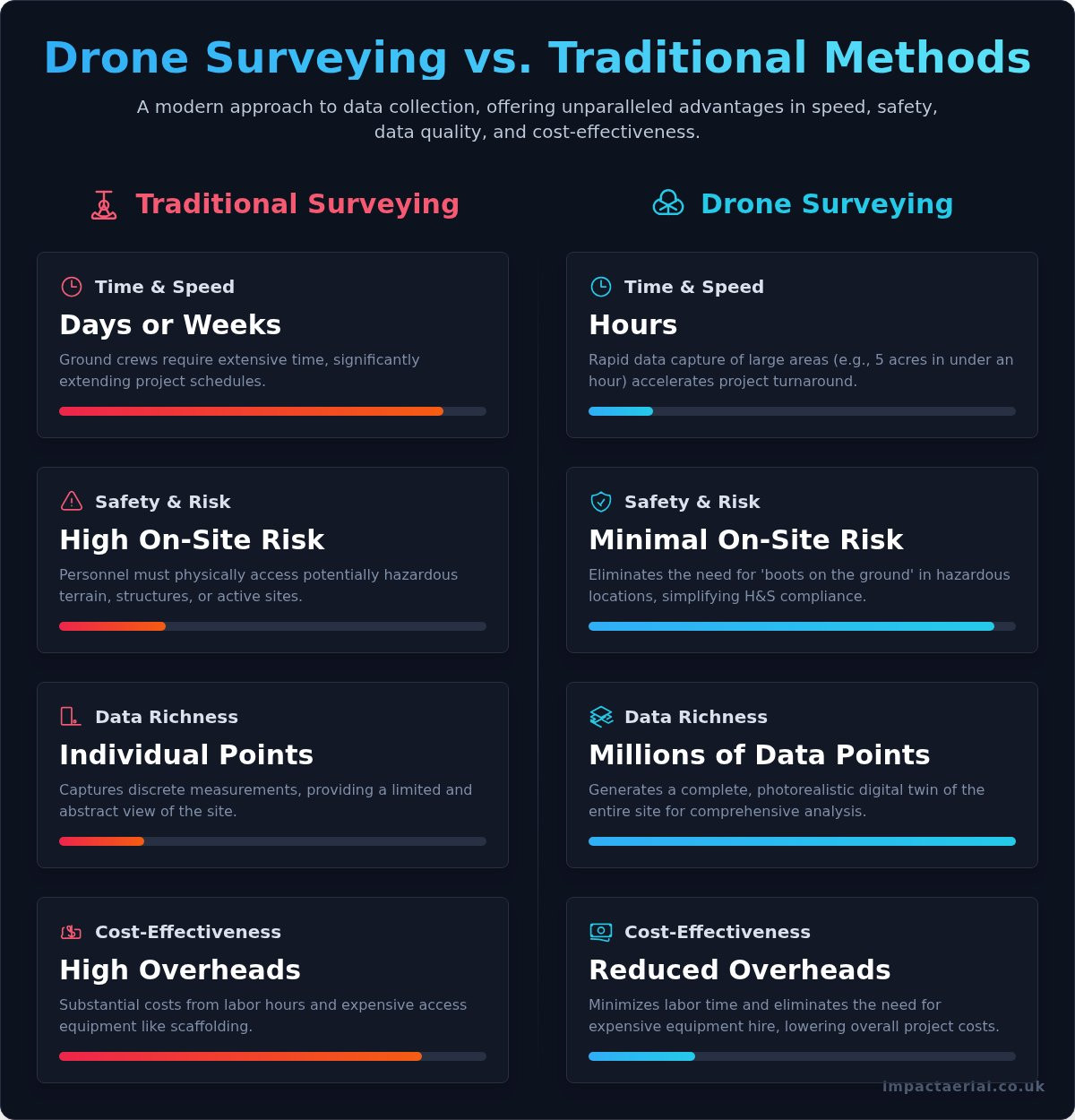
While both methods aim for accuracy, the operational differences are substantial. Drone surveying offers clear, measurable advantages in key areas, providing tangible benefits for project timelines, safety protocols, and overall costs.

  • Time & Speed: A survey that might take a ground crew days or weeks with a total station can often be completed in a matter of hours by a drone, dramatically accelerating project schedules.
  • Safety: Drones eliminate the need for personnel to work at height or navigate dangerous terrain. This significantly reduces on-site risk and enhances compliance with health and safety regulations.
  • Data Richness: Traditional methods capture individual measurement points. A drone captures millions of data points, creating a complete, photorealistic digital record of the entire site that can be analysed from multiple angles.
  • Cost-Effectiveness: By reducing labour hours, minimising equipment hire, and speeding up project turnaround, drone surveying provides a more cost-effective solution for comprehensive data collection.

The Core Benefits of Hiring a Professional Drone Surveyor

Moving beyond traditional surveying methods, the integration of unmanned aerial vehicles (UAVs) offers a transformative approach to data gathering. Engaging a professional drone surveyor provides more than just aerial images; it delivers a strategic advantage grounded in four core benefits: enhanced safety, significant speed and cost efficiencies, and superior data quality. These advantages directly impact your project’s bottom line by reducing risk, accelerating timelines, and enabling more informed, data-driven decisions.

Unmatched Safety and Risk Mitigation

Safety is the most critical advantage of drone surveying. By using a UAV, we eliminate the need for personnel to work at height or access dangerous locations, such as unstable structures, steep embankments, or active industrial sites. This drastically reduces on-site risk and simplifies health and safety compliance documentation. With fewer boots on the ground and minimal site disruption, operations can continue safely while the survey is conducted, ensuring a safer environment for everyone involved.

Significant Time and Cost Savings

The efficiency of aerial data acquisition is unparalleled. A comprehensive survey of a 5-acre site, which could take a traditional team a full day, can often be completed by a drone in under an hour. This rapid data capture leads to faster project turnarounds and quicker decision-making. Furthermore, it eliminates the substantial costs associated with hiring expensive access equipment like scaffolding or cherry pickers, which can run into thousands of pounds and cause significant project delays.

Superior Data Accuracy and Detail

A professional drone survey delivers a far richer dataset than traditional methods. We produce high-resolution orthomosaic maps and detailed 3D point clouds that create a precise digital twin of your site or asset. When combined with Ground Control Points (GCPs), we can achieve centimetre-level accuracy. The level of detail is so reliable that public bodies, such as the NYS Department of Transportation drone program, now use this technology for critical infrastructure management. This creates a complete, auditable snapshot in time, invaluable for progress monitoring, quality assurance, and dispute resolution.

The Drone Surveying Process: From Pre-Flight Planning to Final Deliverables

Contrary to common perception, a professional drone survey is far from a simple point-and-fly operation. It is a meticulous, multi-stage process governed by strict safety protocols and technical precision. A qualified drone surveyor executes a comprehensive workflow designed to ensure accuracy, safety, and the delivery of actionable data. This process is broken down into three distinct phases, from initial consultation to the final handover of assets.

Phase 1: Consultation, Scoping, and Risk Assessment

Every project begins with a detailed consultation to fully understand your objectives, required outputs, and accuracy tolerances. We then conduct a thorough desktop survey, assessing the site for potential hazards and checking all airspace classifications. This is a critical step to ensure full compliance with current UK drone flight regulations as set out by the Civil Aviation Authority (CAA). From this, we create a comprehensive flight plan and a detailed Risk Assessment and Method Statement (RAMS) to guarantee operational safety. We also handle all necessary landowner permissions, providing you with complete peace of mind.

Phase 2: On-Site Data Acquisition

On the day of the survey, our team arrives on-site to establish a secure operational area and conduct final on-site safety checks. For high-accuracy projects, we strategically place Ground Control Points (GCPs), which are surveyed using GPS/GNSS equipment. These points act as a real-world frame of reference for the aerial data. The drone then executes its pre-programmed, automated flight path, capturing hundreds or thousands of high-resolution images with consistent overlap. Throughout the operation, we adhere strictly to our CAA-approved safety protocols and continuously verify data coverage on-site.

Phase 3: Data Processing and Deliverables

Once the data-gathering is complete, the raw imagery is processed using specialist photogrammetry software. This powerful technology stitches the individual photos together to create precise, georeferenced outputs. The final deliverables are tailored to your project’s specific needs and typically include:

  • High-Resolution 2D Orthomosaic Maps: A single, scaled top-down map of your site.
  • Interactive 3D Point Cloud Models: A detailed digital twin of the surveyed area.
  • Digital Elevation/Surface Models (DEM/DSM): To analyse terrain, gradients, and contours.
  • Annotated Inspection Reports: Highlighting specific areas of interest or defects.

All data is securely delivered via a dedicated cloud platform for easy access and integration into your existing workflows. See examples of our survey deliverables.

How to Choose a Qualified Drone Surveyor: Key Credentials to Verify

In the rapidly expanding field of aerial surveying, it’s crucial to understand that not every commercial drone operator possesses the skills, qualifications, or equipment to be a professional drone surveyor. Engaging an unqualified operator can lead to inaccurate data, safety risks, and legal complications. To ensure you receive precise, reliable results and protect your project, it is essential to verify a provider’s credentials.

Use the following checklist as a guide to vetting a potential partner. These are not optional extras; they are the non-negotiable standards of a professional, compliant, and trustworthy aerial surveying company.

Essential CAA Certification: The GVC Qualification

In the UK, any drone operator flying for commercial purposes must hold a valid Operational Authorisation from the Civil Aviation Authority (CAA). The pilot’s competency is demonstrated by a General Visual Line of Sight Certificate (GVC), the successor to the old PfCO permission. This qualification proves the pilot has undergone rigorous theoretical training and practical flight assessment, ensuring they operate safely and in full compliance with UK aviation law. Never engage an operator who cannot provide proof of their CAA Operational Authorisation.

Specialist Commercial Drone Insurance

Standard business insurance does not cover commercial drone operations. A professional surveyor must hold a specialist policy that includes adequate public liability cover, typically for a minimum of £5 million. This insurance is vital as it protects your property, assets, and personnel in the unlikely event of an incident. For added peace of mind, always request a copy of their current insurance certificate before any work commences on your site.

Equipment and Industry Experience

The quality of the final survey data is directly linked to the quality of the equipment and the expertise of the operator. A qualified provider will be transparent about their capabilities and be able to demonstrate a proven track record. Key areas to verify include:

  • Professional-Grade Drones: Look for the use of commercial drones, such as the DJI Enterprise series, which are designed for high-precision data gathering.
  • Relevant Project Portfolio: Ask to see examples of similar survey projects they have completed within your industry, whether it’s construction, property development, or asset management.
  • Data Processing Capabilities: Enquire about the photogrammetry and data processing software they use to convert raw aerial data into actionable 2D maps, 3D models, or inspection reports.
  • Specialist Sensor Experience: If your project requires it, confirm their experience with advanced sensors like LiDAR for detailed topographical mapping or thermal imaging for building inspections.

By verifying these key credentials, you can confidently select a qualified partner who will deliver accurate data while upholding the highest standards of safety and professionalism. At Impact Aerial, we pride ourselves on our transparency and full compliance with all industry regulations.

Common Applications of Drone Surveying Across UK Industries

The versatility of drone surveying has unlocked significant efficiencies across a diverse range of UK sectors. By delivering high-quality, actionable data faster, more safely, and at a lower cost than traditional methods, aerial surveys are becoming an indispensable tool for project managers, asset owners, and environmental consultants. The applications are extensive, demonstrating how a professional drone surveyor can provide critical insights for almost any large-scale project.

Construction and Engineering

In the fast-paced construction industry, timely and accurate data is paramount. Drone surveys provide a complete digital record of a site, mitigating risks and improving project management from planning to completion. Key applications include:

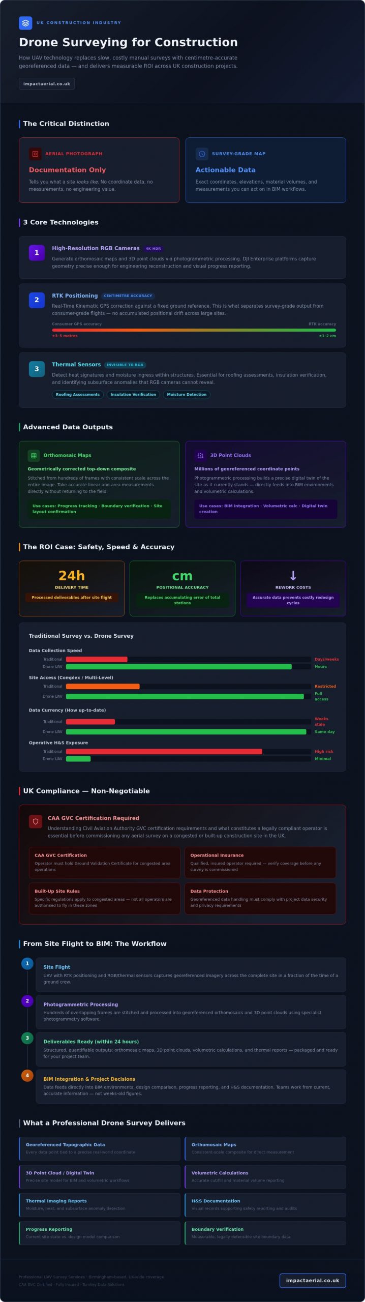
  • Site Progress Monitoring: Regularly capturing high-resolution imagery to track progress against design plans (BIM), identify potential delays, and provide clear updates to stakeholders.
  • Volumetric Calculations: Accurately measuring stockpiles and calculating cut and fill volumes for earthworks, ensuring precise material management and cost control.
  • As-Built Verification: Creating detailed 3D models and point clouds to verify that construction matches the original design, forming the foundation for a comprehensive digital twin.
  • Topographical Surveys: Generating precise land surveys at the start of a project to inform site layout, drainage, and infrastructure planning without extensive ground crew presence.

Property and Building Management

For facilities managers, chartered surveyors, and estate agents, drones offer a revolutionary approach to inspecting and marketing property. They eliminate the need for costly and high-risk manual methods like scaffolding or cherry pickers.

  • Roof and Façade Inspections: Safely identifying defects, damage, or maintenance requirements on building envelopes with high-resolution cameras, minimising risk to personnel.
  • Thermal Imaging: Using thermal cameras to detect heat loss, pinpoint sources of water ingress, and assess the efficiency of insulation or solar panel installations.
  • 3D Models for Marketing: Producing compelling 3D digital models and aerial videography that provide a unique perspective for marketing commercial or residential properties.
  • Dilapidation Surveys: Creating a detailed, time-stamped visual record of a property’s condition at the beginning or end of a lease agreement.

Agriculture and Environmental

The ability to cover vast and often inaccessible terrain makes drone surveying an essential service for modern land management and environmental monitoring. The data gathered supports sustainable practices and informed decision-making.

  • Crop Health Monitoring: Utilising multispectral sensors to analyse crop health, identify stress areas, and optimise irrigation and fertiliser application for precision agriculture.
  • Land Management and Boundary Mapping: Quickly and accurately mapping large estates, farms, and conservation areas to verify boundaries and monitor land use.
  • Coastal Erosion and Flood Risk Assessment: Repeatedly surveying coastlines and riverbanks to monitor environmental changes and provide critical data for risk modelling.

From construction sites in Birmingham to coastal management projects in Cornwall, the applications for a certified drone surveyor are continually expanding. If your project requires precise, safe, and efficient data-gathering, aerial technology offers a clear advantage. Discuss your project with our certified surveyors.

Elevate Your Project with a Professional Drone Surveyor

As we’ve explored, the modern drone surveyor has revolutionised data collection across UK industries by delivering unparalleled speed, safety, and detail. This is more than just flying a drone; it’s a comprehensive process involving meticulous planning, precise data acquisition, and the creation of actionable insights. Ultimately, choosing a qualified and certified operator is paramount to guaranteeing the accuracy, compliance, and overall success of your project.

At Impact Aerial, we provide that essential peace of mind. As specialists in construction and property surveys, our team is fully CAA GVC Certified and insured, operating commercial-grade DJI Enterprise drones to capture top-quality data. If you’re ready to leverage the benefits of aerial surveying, we invite you to request a professional drone survey quote from our CAA GVC certified team. Let’s work together to provide the precise, reliable data you need to move forward with confidence.

Frequently Asked Questions

How accurate is a drone survey compared to traditional methods?

When conducted by a certified professional using Ground Control Points (GCPs) and RTK/PPK enabled drones, a drone survey can achieve survey-grade accuracy, often reaching sub-5cm precision. This level of accuracy is comparable to, and in many cases exceeds, traditional ground-based methods. The primary advantages are significant gains in speed, improved safety by removing personnel from hazardous areas, and the ability to capture comprehensive data sets of the entire site.

What happens if the weather is bad on the day of the survey?

Client and public safety is our paramount concern. All flight operations are conducted in strict accordance with CAA regulations, which include limitations on wind speed, precipitation, and visibility. We meticulously monitor weather forecasts leading up to the scheduled survey. If conditions are deemed unsafe or unsuitable for high-quality data capture, we will liaise with you to reschedule the flight for the next suitable day at no additional cost, ensuring the integrity of your project data.

How much does a professional drone survey cost in the UK?

The cost of a professional drone survey in the UK varies based on project specifics. Factors influencing the price include the size and complexity of the site, the required level of accuracy, and the final data deliverables. A small, straightforward topographical survey might start from around £500, while larger projects requiring extensive data processing will be quoted on a case-by-case basis. We provide a detailed, transparent quotation after an initial consultation to understand your exact requirements.

What is the difference between photogrammetry and LiDAR?

Photogrammetry and LiDAR are two distinct data-gathering methods. Photogrammetry involves capturing hundreds of overlapping high-resolution images, which are then processed to create detailed 3D models and orthomosaic maps. LiDAR, however, uses a laser scanner to emit pulses of light, measuring the return time to create a highly accurate point cloud of a surface. While photogrammetry offers photorealistic colour and texture, LiDAR excels at penetrating vegetation and capturing dense topographical data.

How long does it take to receive the final data after the flight?

The on-site flight for data capture is typically completed within a few hours. The more time-intensive stage is post-processing, where the raw data is converted into actionable insights and deliverables. You can generally expect to receive initial processed data, such as a preliminary point cloud or orthomosaic, within 48 hours. The final, fully-analysed survey reports, 3D models, or volumetric calculations are typically delivered within 3 to 7 working days, depending on the project’s complexity.

Can drones be used for indoor surveys?

Yes, drones can be highly effective for indoor surveys, particularly in large or difficult-to-access spaces like warehouses, storage tanks, or structurally compromised buildings. Specialised drones, often equipped with protective cages and advanced sensors like LiDAR, are used for these GPS-denied environments. These operations require a highly skilled pilot and meticulous planning to ensure safety and capture precise data for asset inspection, inventory management, or Building Information Modelling (BIM).

What are the main legal restrictions for flying a survey drone?

In the UK, all commercial drone operations are governed by the Civil Aviation Authority (CAA). Key restrictions include maintaining Visual Line of Sight (VLOS) with the drone, not exceeding an altitude of 400ft (120m), and adhering to strict separation distances from people and property. Critically, a professional drone surveyor must hold a valid Operational Authorisation, such as a GVC, and have appropriate commercial insurance. This ensures all operations are conducted safely, legally, and with full accountability.

UAV Land Surveying: A Professional’s Guide to Drone-Based Geospatial Data

Is the data captured by a drone truly accurate enough for your project? How do you navigate the technical complexities of Photogrammetry and LiDAR, all while ensuring full compliance with strict UK Civil Aviation Authority (CAA) regulations? These are critical questions for any project manager, developer, or surveyor considering modern data-gathering techniques. The reality is that professional uav land surveying now represents a significant advancement, delivering superior efficiency, safety, and data precision when conducted by certified experts.

This comprehensive guide is designed to provide clarity and confidence. We will demystify the technology behind drone-based geospatial data, explain the high-quality deliverables you should expect, and provide a clear framework for selecting a fully qualified, insured, and CAA-certified provider in the UK. Our goal is to equip you with the knowledge to confidently integrate this powerful tool into your projects, ensuring you receive faster, safer, and more precise results with complete peace of mind.

What is UAV Land Surveying? A Modern Approach to Geospatial Data

UAV land surveying is a professional data-gathering technique that utilises an Unmanned Aerial Vehicle (UAV), or drone, to capture high-resolution survey data from an aerial perspective. This modern approach stands in stark contrast to traditional ground-based methods, which often require extensive fieldwork and manual measurements. By deploying a drone, surveyors can generate highly detailed and accurate digital representations of land, including topographic maps, 3D models, and orthomosaic images, fundamentally enhancing project efficiency, safety, and data density.

To better understand this process, the following video provides a clear overview of UAV surveying in action:

The Key Components of a UAV Surveying System

A successful UAV land surveying operation relies on the integration of four critical components, each playing a vital role in delivering survey-grade results:

  • The Unmanned Aerial Vehicle (UAV): This is not a consumer hobbyist drone. We utilise commercial-grade platforms, such as those from the DJI Enterprise series, designed for stability, reliability, and extended flight times.
  • The Payload: The sensor is the core data-gathering tool. Depending on the project requirements, this can range from high-resolution RGB cameras for photogrammetry to advanced multispectral sensors for agricultural analysis or LiDAR for penetrating vegetation.
  • Ground Control Points (GCPs): To achieve the high level of accuracy required for professional surveying, clearly marked points are placed on the ground and their precise coordinates are measured with survey-grade GPS. These GCPs act as a reference to georeference the drone data accurately.
  • Processing Software: Specialised software is used to process the thousands of images and data points, stitching them together to create actionable outputs such as digital elevation models (DEMs), point clouds, and detailed maps.

Why UAVs are Revolutionising Traditional Surveying

The shift towards drone-based surveying is driven by tangible benefits that directly impact project timelines, budgets, and safety protocols. This technology offers a clear advantage over conventional methods in several key areas:

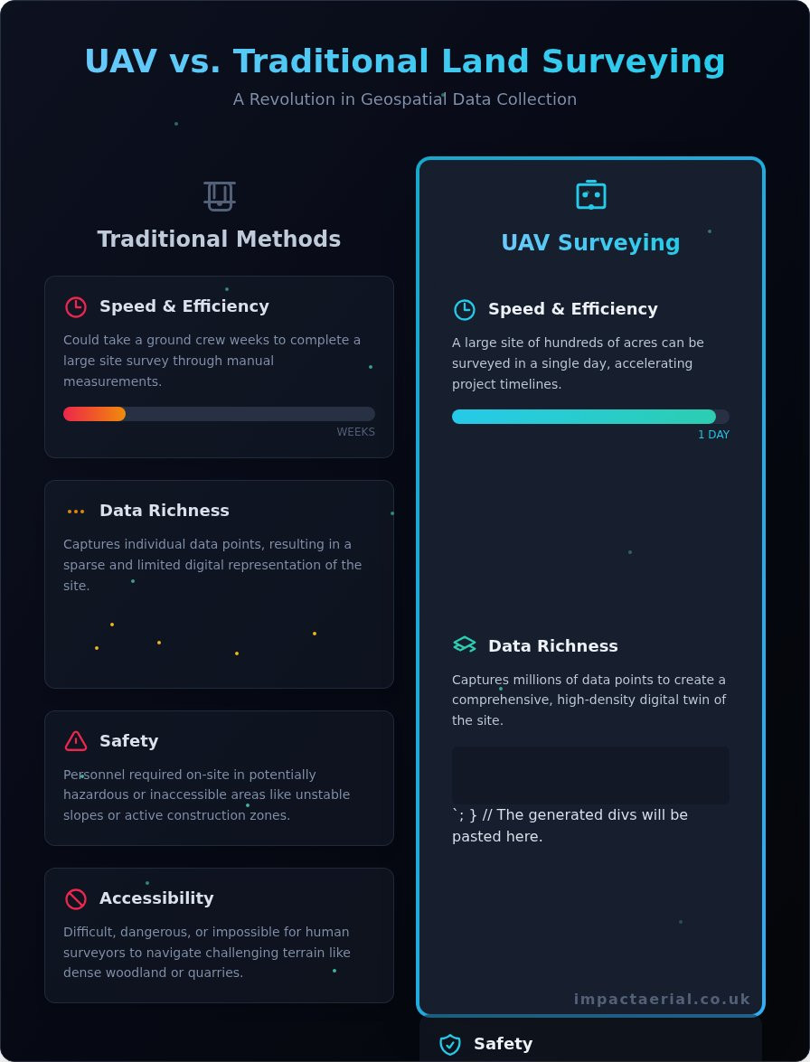
  • Safety: Drones significantly reduce the need for personnel to work in hazardous or inaccessible areas, such as unstable slopes, active construction sites, or busy transport corridors. This commitment to safety is a cornerstone of our CAA-certified operations.
  • Speed & Efficiency: A drone can survey a large site of hundreds of acres in a single day, a task that could take a ground crew weeks to complete. This rapid data acquisition accelerates project timelines from planning to completion.
  • Data Richness: Unlike traditional methods that capture individual points, a UAV survey captures millions of data points, creating a comprehensive and detailed digital twin of the site. This high-density data capture is a significant evolution in modern Aerial Survey Methods, providing unparalleled insight.
  • Accessibility: UAVs can easily access and survey challenging terrain like dense woodland, quarries, or coastal areas that would be difficult, dangerous, or impossible for human surveyors to navigate on foot.

Core Technologies: How Drones Capture Survey-Grade Data

The precision of modern uav land surveying is not accidental; it is the result of sophisticated data capture technologies and meticulous operational procedures. At the heart of this process are two primary methods for data acquisition: Photogrammetry and LiDAR. The selection of which technology to deploy is a critical decision, dictated by the specific requirements of the project, terrain characteristics, and the required level of detail. This data capture is executed using advanced flight planning software for automated, consistent missions, while onboard RTK/PPK technology provides centimetre-level positional accuracy directly to the data.

Understanding Photogrammetry: Creating 3D Models from Images

Photogrammetry is the science of making measurements from photographs. In a drone survey, this involves an automated flight path where the UAV captures hundreds or thousands of high-resolution, overlapping images of a site from different angles. Specialised software then processes these images, identifying common points to stitch them together into a precise, measurable 3D representation. This method is exceptionally effective for visual mapping and produces several key deliverables:

  • Orthomosaic Maps: A single, high-resolution, and geographically corrected aerial image of the entire site.
  • 3D Point Clouds: A dense collection of points in 3D space, forming the digital foundation of the site.
  • Digital Terrain & Surface Models (DTMs/DSMs): Detailed models representing the bare earth and surface features, crucial for volume calculations and site analysis.

LiDAR Surveying: Unmatched Precision with Light

LiDAR, which stands for Light Detection and Ranging, operates differently. A LiDAR sensor mounted on a UAV emits rapid pulses of laser light and measures the time it takes for them to return. This provides an extremely accurate measurement of distance, creating a highly detailed point cloud. LiDAR’s primary advantage is its ability to penetrate vegetation, allowing some laser pulses to reach the ground through tree canopies and dense brush. This makes it the superior choice for forestry management, corridor mapping for utilities, and surveying complex terrain where ground visibility is limited.

The Crucial Role of Ground Control Points (GCPs)

To achieve true survey-grade accuracy, drone data must be anchored to a real-world coordinate system. This is accomplished using Ground Control Points (GCPs), which are physical markers placed on the site whose precise coordinates have been measured by a surveyor using traditional GPS equipment. By tagging these known points within the drone data, we can georeference the entire model, dramatically increasing its absolute accuracy. While modern RTK/PPK-enabled drones can reduce the number of GCPs required, their use remains a best practice for projects demanding the highest levels of precision.

Key Applications & Deliverables Across UK Industries

The true value of UAV land surveying lies in its remarkable versatility. Across the UK, from major construction projects in Birmingham to rural land developments in the West Midlands, the technology delivers high-quality, actionable data that drives efficiency, enhances safety, and improves project outcomes. The applications are as diverse as the industries they serve, each requiring specific data outputs to inform critical decisions.

Construction & Earthworks: Volume Calculations and Progress Monitoring

On active construction sites, speed and accuracy are paramount. UAVs excel at measuring stockpile volumes for precise inventory management and conducting cut-and-fill analysis to optimise earthworks, saving significant time and cost. Furthermore, regular flights allow for detailed progress monitoring against Building Information Modelling (BIM) designs, identifying discrepancies early. Upon completion, a final UAV flight produces a comprehensive as-built survey for client handover.

Topographic Surveys for Property & Land Development

For architects, planners, and developers, a detailed understanding of the terrain is fundamental. Our professional uav land surveying services generate highly accurate topographic data, producing detailed contour maps essential for site design and planning applications. This data also underpins critical flood risk assessments by creating precise Digital Terrain Models (DTMs). The resulting high-resolution aerial imagery also serves as a powerful tool for marketing materials and stakeholder presentations.

What to Expect: Common Data Deliverables Explained

The sophisticated data gathered during a survey mission is processed into several industry-standard formats. While project requirements vary, clients can typically expect to receive a combination of the following high-quality deliverables:

  • Orthomosaic Map: A single, high-resolution, and geometrically corrected aerial photograph of the entire site, free from distortion and perfectly to scale.
  • Digital Surface/Terrain Model (DSM/DTM): A 3D model representing the site’s elevation. A DSM includes all surface features like buildings and vegetation, while a DTM shows the bare earth, crucial for land analysis.
  • 3D Point Cloud: A dense collection of millions of individual data points, each with a precise XYZ coordinate, which forms the foundational data for creating all other 3D models and maps.
  • Contour Lines: Traditional vector lines that connect points of equal elevation, providing a familiar and intuitive way for engineers and designers to visualise the site’s topography.

Understanding these outputs is key to unlocking the full potential of aerial data for your project. For a detailed consultation on your specific data requirements, please contact our team of certified professionals.

Choosing a Professional UAV Survey Provider in the UK

As the benefits of UAV technology become more apparent, the market has seen a rise in operators. However, it is crucial to understand that professional uav land surveying is a highly specialised discipline that extends far beyond simply flying a drone. The accuracy of your project data depends entirely on the provider’s technical expertise, regulatory compliance, and methodical approach. Vetting a potential partner is essential to ensure you receive reliable, actionable data while adhering to strict UK safety standards.

Non-Negotiable Credentials: CAA Certification and Insurance

In the UK, any commercial drone operation is regulated by the Civil Aviation Authority (CAA). Your chosen provider must hold a valid operational authorisation, typically proven with a General Visual Line of Sight Certificate (GVC). Furthermore, they must have adequate commercial liability insurance; a policy of at least £5 million is a standard benchmark for professional services. Always request to see proof of these documents before any work commences. Affiliations with industry bodies like ARPAS-UK also serve as a strong indicator of a provider’s commitment to best practices.

Assessing a Provider’s Technology and Experience

The quality of the final survey data is directly linked to the equipment and software used. Inquire about the drones and sensors in their fleet; professional-grade platforms like the DJI Enterprise series are designed for high-accuracy data gathering. Ask to see case studies or examples of projects similar to your own to verify their experience. A competent provider will have a clear, documented workflow and demonstrable expertise in processing software for photogrammetry and LiDAR to generate precise, survey-grade outputs.

Questions to Ask Before Hiring a Drone Surveyor

To ensure you partner with a competent and safe operator, we recommend asking several key questions before commissioning any work. A professional provider will welcome this scrutiny and provide clear, confident answers.

  • What is your safety procedure and risk assessment process? They should be able to provide detailed Risk Assessments and Method Statements (RAMS).
  • What level of accuracy can you achieve for this project? They should discuss Ground Sample Distance (GSD) and the expected absolute accuracy of the final data.
  • What are the final deliverables and in what file formats? Confirm you will receive the data you need, such as Orthomosaics, Point Clouds, or DTMs, in compatible formats like GeoTIFF, LAS, or DXF.

Ensuring your provider meets these standards is fundamental to the success of your project. Impact Aerial is fully certified and insured for your peace of mind.

Elevate Your Project with Professional UAV Land Surveying

As this guide has demonstrated, the shift towards drone-based data capture represents a significant leap forward in efficiency, safety, and accuracy. For industries across the UK, from construction to property management, the adoption of professional uav land surveying is no longer a novelty but a strategic necessity for acquiring high-quality geospatial data. The key to unlocking these benefits, however, lies in partnering with a provider who possesses not only the right technology but also the regulatory credentials and industry expertise to deliver reliable results.

At Impact Aerial, we provide this essential expertise. As specialists in construction and property surveys, our team of CAA GVC Certified and fully insured pilots operates a fleet of commercial-grade DJI Enterprise drones to ensure every project meets the highest standards of precision and safety. We are committed to providing the top-quality data you need for informed decision-making, giving you complete peace of mind.

Ensure precision and safety on your next project. Contact Impact Aerial for a professional UAV survey consultation.

Frequently Asked Questions

How accurate is UAV land surveying compared to traditional methods?

When conducted professionally using Real-Time Kinematic (RTK) or Post-Processed Kinematic (PPK) GPS technology and Ground Control Points (GCPs), UAV land surveying achieves outstanding accuracy. We consistently deliver results with a relative accuracy of 20-50mm, which is comparable to, and often exceeds, the precision of many traditional ground-based methods. This level of detail provides a robust and reliable dataset for topographical analysis, volume calculations, and site planning, ensuring high-quality, actionable intelligence for your project.

What happens if the weather is bad on the scheduled survey day?

Client safety and data quality are our primary concerns. We operate strictly within Civil Aviation Authority (CAA) guidelines, which prohibit flight operations in high winds, rain, or other adverse conditions. If the weather is unsuitable on the scheduled day, we will proactively contact you to reschedule the flight for the next available opportunity at no additional cost. This professional diligence ensures the safety of the operation and the integrity of the final survey data we deliver.

Is it legal to use a drone for surveying in restricted airspace in the UK?

Operating a UAV in restricted airspace, such as near airports, prisons, or sensitive government sites, is heavily regulated by the CAA and requires specific, prior authorisation. As fully certified commercial operators, we have the expertise and qualifications to manage this complex application process. While not guaranteed, we can liaise with the relevant authorities to seek the necessary permissions as part of our comprehensive project planning, ensuring all operations are fully compliant and legal.

How long does a typical UAV survey take from flight to final data?

The timeline for a complete UAV survey is significantly faster than traditional methods. The on-site data-gathering flight for a typical 10-20 hectare site can often be completed in just a few hours. The subsequent data processing, which involves photogrammetry to create the 3D models and orthomosaics, generally takes between 24 and 48 hours. This means you can have highly detailed, actionable survey data delivered to your team in a matter of days, not weeks.

What data formats can I expect, and are they compatible with my existing software (e.g., AutoCAD)?

We provide data in a range of industry-standard formats to ensure seamless integration with your existing workflows. Common deliverables include high-resolution Orthomosaic maps (GeoTIFF), 3D Point Clouds (.LAS, .LAZ), Digital Surface/Terrain Models (DSM/DTM), and 3D textured mesh models (.OBJ). For direct use in design software, we can export topographic linework and contours as .DWG or .DXF files, ensuring full compatibility with platforms like AutoCAD, Civil 3D, and other GIS applications.

Can drones survey through trees and vegetation?

Standard photogrammetry, which uses high-resolution cameras, captures the top surface of objects, meaning it will map the canopy of dense trees and vegetation, not the ground beneath. For projects requiring accurate ground-level data in vegetated areas, a different technology is required. We can deploy specialised UAVs equipped with LiDAR (Light Detection and Ranging) sensors, which can penetrate tree cover to capture the true ground topography, providing a complete and accurate terrain model.