
Scaling a scaffold for a routine inspection isn’t just a logistical headache; it’s a liability that often costs UK firms thousands in unnecessary downtime and safety risks. You’re likely already aware that traditional site monitoring is slow, expensive, and frequently puts personnel in harm’s way. In an industry where margins are tight and deadlines are non-negotiable, waiting days for manual data collection is no longer a viable strategy for project success.
Professional construction drone services UK have transitioned from a specialist novelty to a critical data-management tool for risk mitigation and lifecycle efficiency. By integrating high-resolution aerial imaging and precision thermal data, sites can significantly reduce downtime and eliminate the high costs of manual height inspections. This guide provides a professional overview of how these services enhance safety and accuracy across the UK construction lifecycle. We’ll explore the technical capabilities of DJI Enterprise hardware, the importance of CAA GVC certification, and how to navigate the latest 2026 regulatory shifts. From our base in Birmingham to projects nationwide, we’ll show you how to leverage aerial data for better project outcomes and meticulous site monitoring.
Key Takeaways
- Learn how modern UAV technology provides more than just photography, acting as a technical data-collection tool for precise topographical and volumetric analysis.
- Discover how construction drone services UK mitigate site risks by replacing high-risk manual inspections with safer, more efficient aerial site monitoring.
- Understand the critical importance of CAA GVC certification and current UK regulatory compliance to ensure your operations remain legally sound in complex urban environments.
- See how integrating data from enterprise-grade DJI hardware into your existing BIM software streamlines reporting and enhances long-term project decision-making.
- Explore the Impact Aerial approach to full-service project management, ensuring precision from the initial consultation through to final data delivery.
What are Construction Drone Services and Why Do They Matter?
Professional construction drone services UK represent the expert application of Unmanned Aerial Vehicles (UAVs) to capture high-resolution technical data, imagery, and video across the build lifecycle. While early adoption often focused on simple marketing photography, the sector has evolved into a rigorous, data-centric discipline. Today, drones are essential for site monitoring, providing stakeholders with verifiable evidence of progress and structural integrity. For UK contractors, this technology provides a definitive solution to the “working at height” dilemma, significantly reducing the risks associated with manual inspections.
The value of these services lies in their precision and reliability. Professional operators don’t just fly; they manage complex data-gathering missions that inform critical decision-making. By leveraging commercial-grade hardware, firms can achieve a level of site oversight that was previously impossible without enormous expense or physical risk. This shift ensures that every flight delivers a tangible return on investment through enhanced safety and rapid data turnaround.
The Evolution of Aerial Data in the UK Build Sector
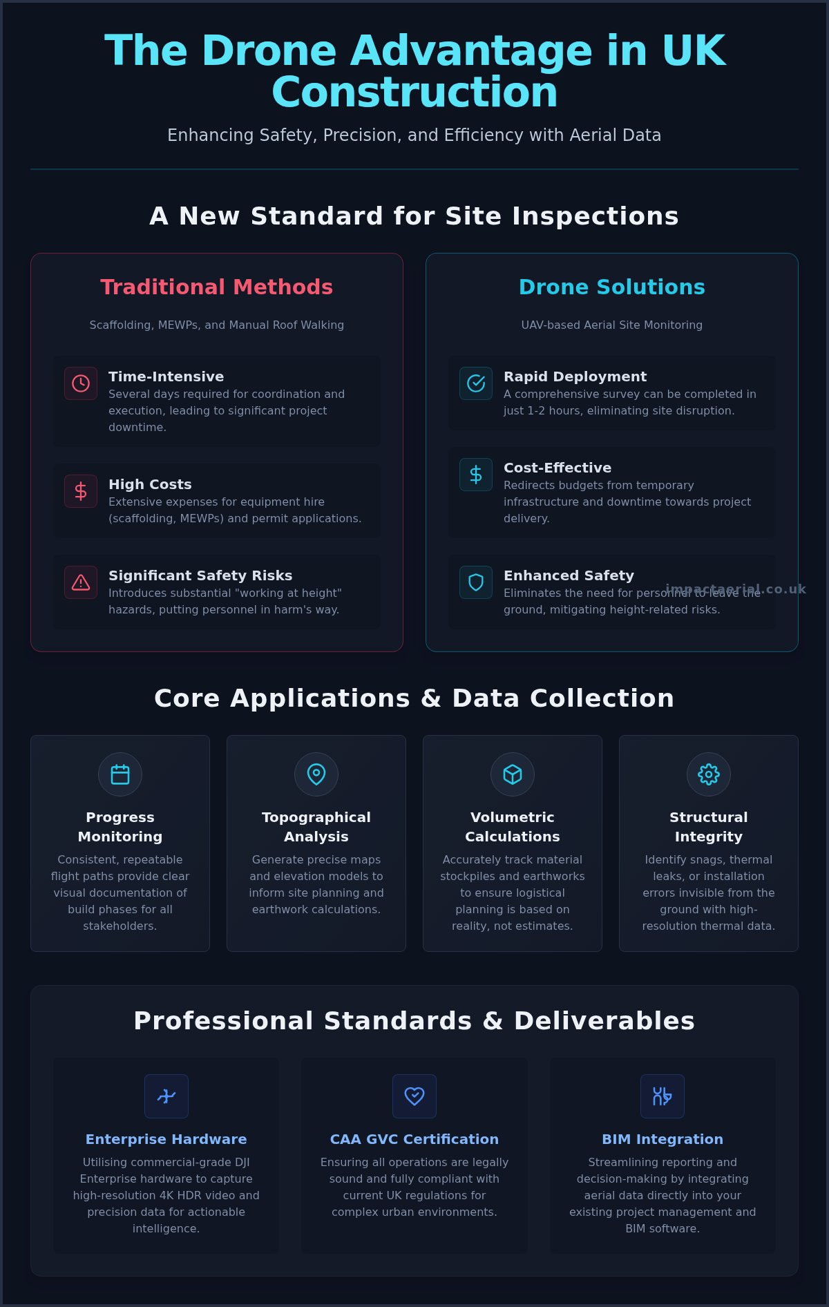
The industry has moved far beyond basic aerial snapshots. Modern workflows now rely on sophisticated survey drone technology to generate actionable intelligence. By integrating DJI Enterprise hardware capable of 4K HDR output, operators can identify structural snags, thermal leaks, or installation errors that remain invisible from the ground. This transition into technical data collection ensures that aerial insights are no longer just “nice-to-haves” but are instead integrated directly into project management software to track milestones with precision. This data-first approach allows for better resource allocation and ensures that project timelines remain on track through every phase of the build.
Replacing Traditional Access Methods
Consider the logistical burden of traditional access. Scaffolding, Mobile Elevated Work Platforms (MEWPs), and manual roof walking require extensive planning, permit applications, and significant hire costs. They also introduce substantial health and safety hazards for site personnel. In contrast, professional construction drone services UK offer a safer, non-invasive alternative that eliminates the need for personnel to leave the ground for routine checks.
A typical manual roof inspection might take several days to coordinate and execute, often causing site disruption and downtime. A professional drone deployment can often complete the same survey in one to two hours. This rapid turnaround allows site managers to receive high-fidelity data without pausing construction activities or compromising the safety of their workforce. By removing the need for physical access equipment, contractors can redirect budgets toward project delivery rather than temporary infrastructure.
Core Applications: Construction Site Monitoring and Data Collection
Effective site management requires more than occasional snapshots; it demands a systematic approach to data acquisition. Professional construction drone services UK provide a continuous record of a project’s evolution, from the first ground-breaking ceremony to the final handover. This lifecycle approach ensures that every stakeholder, from site managers to remote investors, has access to a single source of visual truth. By utilising commercial-grade equipment, we capture precise metrics that inform topographical analysis and volumetric calculations. It’s about the data. Tracking material stockpiles and earthworks with high accuracy ensures that logistical planning remains grounded in reality rather than estimates.
Progress Monitoring and Stakeholder Communication
Regular monitoring relies on repeatable flight paths. By using automated mission planning, we ensure that images are captured from the exact same coordinates every week or month. This consistency allows for the creation of high-quality time-lapse sequences and side-by-side comparisons that document build phases with absolute clarity. Beyond the raw data, professional drone photography serves as a powerful communication tool. Our post-production services transform these technical assets into polished progress reports that facilitate smoother project meetings and provide clear evidence for investor updates. It keeps everyone on the same page.
Technical Surveys: Thermal and 3D Modelling
Technical applications extend into specialised surveying, where thermal imaging and 3D modelling provide insights that traditional methods miss. For building envelopes, thermal-capable UAVs identify heat loss and moisture ingress without requiring invasive testing or expensive scaffolding. We also provide dedicated PV solar farm thermal surveys to detect faulty cells or string failures across vast arrays quickly. These “evidence-first” data sets support qualified surveyors by providing detailed orthomosaics and 3D models for precise geometry measurements. The result is a comprehensive digital twin of the site that can be referenced long after the physical work is complete. If you’re looking to enhance your project’s oversight, exploring professional site monitoring can provide the technical edge your team needs.
Safety and Compliance: UK Drone Regulations for Construction
Safety is the cornerstone of every successful build, and the integration of construction drone services UK must be managed with the same rigour as any other heavy plant operation. Operating a UAV on a busy site isn’t merely about flight; it’s about adhering to a strict regulatory framework designed to protect people, property, and project timelines. For any commercial deployment, the legal and operational responsibilities are significant. Engaging a provider that treats compliance as a baseline requirement ensures that your project remains protected from the legal and financial repercussions of unauthorised flight.
Risk mitigation begins long before the drone leaves the ground. Professional operators conduct thorough pre-flight assessments and establish site-specific safety protocols that align with your existing health and safety management systems. This meticulous planning is backed by £5m commercial liability insurance, providing the necessary reassurance that project risks are professionally managed. In an industry where liability is a constant concern, this level of coverage is a non-negotiable standard for professional service providers.
Navigating the CAA Regulatory Framework
Understanding the distinction between different certifications is vital for project managers. While an A2 CofC allows for some basic operations, the gold standard for complex construction environments is hiring CAA GVC certified pilots. The General Visual Line of Sight Certificate (GVC) is a professional qualification that requires a robust Operations Manual and a practical flight test, proving the pilot can handle the specific demands of the “Specific Category” of flight.
Hiring “hobbyist” pilots or uncertified staff poses a massive risk. These individuals often lack the required insurance and the operational experience to navigate congested areas safely. Furthermore, professional providers must be registered with the Information Commissioner’s Office (ICO). Because drones capture high-resolution imagery that may include identifiable individuals or private property, being ICO-compliant ensures that your project’s data handling meets UK GDPR standards, protecting you from privacy-related litigation.
Operational Safety on Busy Sites
Executing a safe flight on an active site requires clear communication and defined boundaries. We establish dedicated take-off and landing (TOAL) zones that are cordoned off from site traffic and personnel. Coordination with site managers is essential; we ensure that all flight times are scheduled to avoid interfering with crane movements or high-risk ground activities.
Urban environments and city-centre sites introduce additional complexities, such as flight restrictions and signal interference from tall structures. Navigating these challenges requires advanced DJI Enterprise hardware equipped with obstacle avoidance and redundant systems. By maintaining constant communication with site leads and following a methodical checklist, we ensure that construction drone services UK remain a safe, seamless addition to your site’s operational workflow.
The Deliverables: How Drone Data Aids Decision Making
Data is the primary currency of modern construction. In the context of construction drone services UK, the deliverables we provide are designed to be actionable technical assets rather than just visual records. We understand that site managers and surveyors don’t have time to sift through thousands of unsorted files. We implement rigorous file structure and naming conventions that align with industry-standard project management workflows. This methodical approach ensures that aerial data integrates seamlessly into existing surveyor reports and Building Information Modelling (BIM) software, allowing for immediate comparison between “as-built” and “as-designed” plans. This keeps everyone on the same page.
For those seeking professional construction drone services UK, the end product must provide clarity and precision. Whether it’s a high-resolution map or a detailed structural inspection, the goal is to provide a single source of truth that reduces ambiguity and accelerates project timelines. While our focus remains on technical precision, for projects that also require high-impact creative storytelling, Dark Falcon Productions offers the specialist production expertise needed to showcase your build in its best light. By delivering data that is ready for immediate review, we help teams identify potential issues before they become costly delays.
Structural integrity checks require the highest possible fidelity. By using 4K HDR sensors, we capture structural details that are often invisible to the naked eye from the ground. We provide a tiered delivery system: RAW data for engineering analysis and post-produced video for stakeholder communication. This versatility ensures that a single flight serves multiple departments. Our live-streaming capabilities also allow for remote site inspections, enabling real-time collaboration between on-site teams and off-site experts. Cloud-based delivery ensures these assets are accessible the moment post-production is complete, removing delays in the decision-making chain.
3D Orthomosaics and Volumetric Data
Using advanced photogrammetry, we convert aerial imagery into geometrically corrected 3D maps. These orthomosaics allow for precise measurements of distance, area, and volume directly from a digital interface. Calculating stockpile volumes or monitoring excavation progress becomes a matter of minutes rather than hours of manual surveying. This data provides a level of accuracy for topographical assessments that significantly reduces the margin for error in material planning and logistics.
Beyond technical maps, we create immersive virtual tours that provide a 360-degree orientation of the site. These tours are essential for complex site inductions and investor walkthroughs, offering a clear perspective on project scale and progress. If you’re looking to enhance your site’s data accuracy, reach out to Impact Aerial for professional survey and monitoring deliverables.
Choosing a UK Drone Service Provider: The Impact Aerial Approach
Selecting a partner for construction drone services UK requires a fundamental shift in perspective. It isn’t enough to hire an operator who can simply “fly and film”; modern build projects demand a technical consultant mindset. At Impact Aerial, we approach every mission as a data-gathering exercise that must integrate with your site’s existing safety and operational workflows. We provide full-service project management, guiding you from the initial consultation through to the final delivery of post-produced technical assets. This comprehensive oversight ensures that the data we capture is accurate, relevant, and immediately useful for your engineering and management teams.
Reliability is non-negotiable in commercial environments. We exclusively utilise DJI Enterprise-grade hardware, which offers the redundancy and precision required for 4K HDR structural inspections and thermal surveys. While we’re proudly based in Birmingham and deeply rooted in the West Midlands, our operations extend UK-wide. This regional expertise, combined with a national reach, allows us to provide a consistent, high-tier service across multiple project locations for Tier 1 contractors and independent developers alike.
Our Professional Standards and Certifications
Our commitment to safety is evidenced by our meticulous adherence to CAA regulations. Every pilot in our team is CAA GVC certified, ensuring they possess the specific qualifications needed to operate in the “Specific Category” within complex urban environments. We don’t just maintain these standards; we actively track transitions in industry regulations to ensure our clients remain compliant. To provide absolute peace of mind, we maintain £5m commercial liability insurance. This level of coverage is essential for managing the inherent risks of active construction sites and ensures that we meet the stringent vetting requirements of the UK’s leading build firms.
Partnering for Long-Term Project Success
We don’t view our work as one-off site visits. We aim to build long-term partnerships that support your project from ground-breaking to final handover. We offer tailored drone services for property, construction, and advertising, ensuring that the visual data we provide serves multiple departments within your organisation. Whether you need regular site monitoring or a specialised thermal survey for a PV solar farm, we adapt our flight missions to meet your specific technical requirements.
Requesting a site-specific risk assessment and quote is the first step toward more efficient site oversight. We provide detailed, evidence-first proposals that outline exactly how our aerial data will benefit your project’s bottom line. Contact Impact Aerial today to discuss your next project and discover how our professional approach to construction drone services UK can enhance your site’s safety and efficiency.
Advancing Site Intelligence with Professional Aerial Data
The integration of professional drone technology represents a fundamental shift toward data-centric site management for the UK build sector. By replacing high-risk manual inspections with high-resolution site monitoring, contractors achieve greater accuracy while significantly reducing operational downtime. Technical deliverables like 3D orthomosaics and thermal surveys provide a single source of truth that streamlines decision-making and ensures project transparency from ground-breaking to handover.
Choosing a partner for construction drone services UK means prioritising safety and technical expertise. As a Birmingham based specialist with UK wide coverage, Impact Aerial provides the regulatory assurance Tier 1 contractors require. Our CAA GVC certified pilots and £5m commercial liability insurance ensure that every mission is conducted with meticulous attention to risk mitigation and compliance. We’re ready to help you transform your site data into a powerful asset for long-term project success.
Request a Professional Construction Drone Quote today to enhance your next project’s safety and efficiency. We look forward to supporting your site’s operational goals with precision and reliability.
Frequently Asked Questions
Are drone surveys legal on UK construction sites?
Yes, drone surveys are entirely legal provided the pilot holds the correct CAA certifications and follows site-specific safety protocols. For commercial work on active sites, pilots must have a valid Flyer ID and Operator ID, along with specific operational authorisations. We ensure all flights comply with current UK aviation laws, including the 2026 regulatory updates regarding weight thresholds. Legal compliance protects the contractor from liability and ensures data is admissible for official reports.
How much does a construction drone survey cost in the UK?
Pricing for a professional survey varies based on the project’s scale, the technical deliverables required, and the complexity of the site environment. While industry rates often distinguish between rapid progress updates and complex topographical mapping, every project requires a tailored quote. Factors like the need for thermal sensors or 3D modelling will influence the final cost. Clients should request a site-specific assessment to ensure the quote covers all necessary insurance and regulatory permissions.
What insurance coverage should a professional drone pilot have?
A professional operator must hold specialist commercial drone insurance that is compliant with EC 785/2004. For Tier 1 construction projects, a minimum of £5m commercial liability insurance is the industry standard to manage potential risks effectively. This coverage protects the client, the public, and property in the event of an incident. We maintain this level of insurance as a baseline to ensure our clients are fully protected during every deployment on active build sites.
Can drones fly in rain or high winds on a construction site?
Operational limits depend on the specific hardware used, though most enterprise drones can handle moderate winds up to 22mph. While DJI Enterprise models have ingress protection ratings that allow for flight in light precipitation, heavy rain or gale-force winds will ground a flight for safety and data quality reasons. We constantly monitor local meteorological data to schedule flights during optimal windows, ensuring the captured 4K HDR imagery remains clear and technically accurate.
What is the difference between GVC and A2 CofC for construction?
The GVC is the professional standard for complex construction drone services UK, allowing for flight in the “Specific Category” near people and property. It requires a robust Operations Manual and a practical flight test. In contrast, the A2 CofC is a more basic certification for lower-risk “Open Category” flights. For congested or high-risk construction environments, the GVC provides the higher level of regulatory authorisation and safety assurance that most contractors require.
How quickly can I receive the data after a drone site survey?
Initial high-resolution imagery and RAW video can often be delivered via cloud-based platforms within 24 hours of the flight. More complex technical deliverables, such as 3D orthomosaics, volumetric data, or post-produced progress reports, typically require 48 to 72 hours for processing and quality assurance. Our methodical post-production workflow ensures that all data is correctly named and structured, making it immediately ready for integration into your BIM software or surveyor reports.
Do I need to clear the site before a drone flight?
Full site clearance is rarely necessary, but we do require a cordoned-off take-off and landing zone for safety. We coordinate closely with site managers to ensure the flight path avoids active crane movements or high-risk ground operations. By establishing clear communication protocols and using drones equipped with 360-degree obstacle avoidance, we can conduct construction drone services UK without disrupting the ongoing work of your subcontractors or heavy plant machinery.
Can drones capture thermal data for building inspections?
Yes, enterprise drones equipped with radiometric thermal sensors are highly effective for identifying heat loss, moisture ingress, and structural anomalies. This technology is particularly valuable for building envelope assessments and PV solar farm surveys, where it can detect faulty cells or insulation gaps invisible to the naked eye. The resulting thermal maps provide “evidence-first” data that allows surveyors to pinpoint issues without the need for invasive testing or expensive scaffolding.

 2 Norton Drive, Wythall, Birmingham, B47 6HH Company registration number: 11138586. VAT Number: 366 9068 55


