
Aerial Inspection for Commercial Insurers: A Practical Guide

Aerial imagery can make a hard-to-reach roof easier to assess, but it cannot make an insurance decision on its own. For aerial inspection for commercial insurers, the value lies in clear, relevant evidence that helps property professionals understand visible conditions in context. Drone surveys can reduce the need for scaffolding and limit site disruption, though they do not replace every form of inspection.

Underwriters, surveyors and loss adjusters need more than a collection of striking images: they need material they can interpret and use. This guide explains where drone imagery can support commercial property inspections, what evidence it can capture and what to request in the final handover. It also covers how to scope a safe, well-documented survey and assess operator credentials. Impact Aerial’s operators are CAA-GVC Certified, the company holds full UK CAA Operational Authorisation, and it carries £5 million commercial liability insurance. A structured process from consultation through to handover and sign-off can provide useful visual records without treating them as a substitute for professional judgement.

Key Takeaways

  • Aerial inspection for commercial insurers can provide useful views of roofs, façades and elevated structures that may be difficult to access during a property review.
  • High-resolution imagery can show visible conditions, but should support rather than replace a wider professional assessment.
  • Drone surveys can reduce the need for scaffolding, although conventional access may still be required for closer examination.
  • A clear brief and structured handover help make inspection imagery more practical for property teams.
  • Impact Aerial’s staged workflow, operator credentials and insurance are relevant considerations when commissioning a well-scoped inspection.

Aerial inspection for commercial insurers: when is it useful?

An aerial inspection captures visual material that can help review visible areas of a building’s exterior. For aerial inspection for commercial insurers, it can provide views of roofs, façades and elevated structures that are difficult to assess from ground level. The imagery supports a property review; it does not decide a claim, determine coverage or replace an insurer’s or surveyor’s assessment.

Using unmanned aerial vehicle (UAV) technology, a drone can capture selected exterior views without requiring someone to reach every viewing position physically. This can be useful at commercial premises with extensive roofs, multi-storey façades or elevated building features. Similar visual documentation can support reviews of residential built environments.

The purpose may be routine or prompted by a specific concern. Routine condition documentation can record visible exterior features as part of a broader property review—an approach standard across the inspection sector, where property inspection firms such as anchorpointinspection.com evaluate exterior elements to complement comprehensive building assessments. If damage has been reported, a focused inspection can capture relevant areas for later professional consideration. For example, after a storm, imagery may show visible roof or façade conditions, but it cannot establish what caused them or determine the outcome of an insurance assessment.

Which commercial property situations can aerial imagery support?

Use aerial imagery when a review needs clearer views of exterior areas that are difficult to see from the ground. These may include roof surfaces, upper façades and elevated structures on commercial or residential buildings. For a reported-damage scenario, the brief can direct attention to the visible area of concern. For general documentation, it can cover agreed exterior areas. The resulting images inform a review, not a claim decision.

What questions should the inspection answer?

Start with the insurer’s purpose and define the building areas in scope. Is the aim to document general visible condition or capture imagery around a reported concern? Identify the property and relevant areas, then explain what the later reviewer needs to examine. A clear brief aligns capture with the question and makes the material easier for surveyors or other property professionals to interpret.

  • General condition: Which roof, façade or elevated areas should be documented?
  • Reported concern: Where is the visible issue, and what surrounding context would help a reviewer?
  • Review needs: Who will use the imagery, and what should the handover make clear?

These distinctions keep the inspection focused. Images gathered for broad condition records may not provide the detail needed around a specific concern, while narrowly targeted capture may not show the wider exterior. Agreeing the purpose first helps set realistic expectations for the evidence and its role in the property review.

What evidence can an insurer receive from a drone inspection?

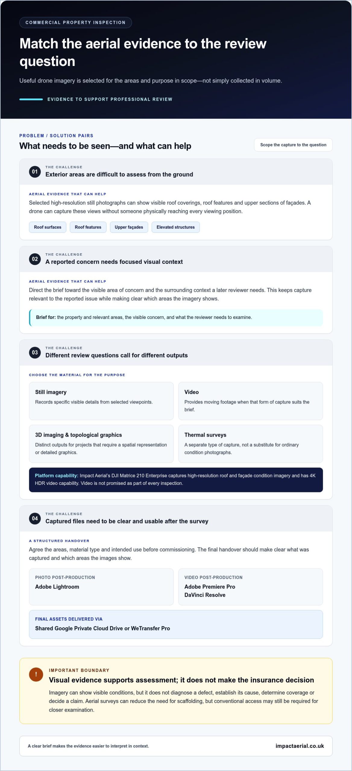
The useful question is not simply how many images a survey produces, but whether the selected material helps a reviewer examine the areas in scope. Impact Aerial’s DJI Matrice 210 Enterprise platform captures high-resolution roof and façade condition imagery and has 4K HDR video capability. Aerial inspection for commercial insurers can be scoped around the evidence required, rather than assuming every project needs the same output.

Still photographs can document visible exterior conditions from selected viewpoints, including roof coverings, roof features and upper sections of a façade. They provide visual records for later professional review, but do not diagnose a defect, establish its cause or reach a claim conclusion. A useful handover should make clear what was captured and which areas the images show, without presenting them as a technical determination.

Still imagery, video, 3D imaging, and thermal surveys

Each output serves a different purpose. Still imagery records specific visible details, while video offers moving footage when that form of capture suits the brief. The platform’s 4K HDR video capability describes what it can capture, not a promise that every inspection includes video. Impact Aerial also provides 3D imaging, detailed topological graphics and Thermal Image Surveys. These are distinct capabilities, selected according to the project’s requirements rather than treated as interchangeable evidence.

For example, a request focused on visible roof or façade condition may call for still images, while a project requiring a spatial representation may specify 3D imaging or detailed topological graphics. A thermal survey is a separate type of capture, not a substitute for ordinary condition photographs. Agreeing the inspection question first helps the commissioning team identify relevant outputs and understand what they can support.

Turning captured material into a usable handover

Capture is only part of the evidence process. Post-production includes Adobe Lightroom for photos, and Adobe Premiere Pro and DaVinci Resolve for video. Impact Aerial delivers final assets via a shared Google Private Cloud Drive or WeTransfer Pro. A clear handover helps the reviewing team locate and interpret the agreed material; it does not imply that editing has verified a condition or determined a claim.

Before commissioning, specify the areas to capture, the type of material required and how the insurer or property professional will use it. This keeps the scope focused and helps the operator prepare relevant outputs instead of an unfocused collection. The complete drone survey guide explains how aerial data collection can be structured. For a project-specific commercial property survey, Impact Aerial’s drone inspection service can be scoped around the building and its review needs.
Aerial Inspection for Commercial Insurers: A Practical Guide

Drone inspection versus conventional access: strengths and limits

A drone can capture roof and façade views without putting an inspector at each elevated viewing point. This can reduce the need for scaffolding and associated site logistics, particularly when the purpose is to document visible exterior conditions. It does not remove the need for conventional access in every case. A close physical inspection or further investigation may still be needed to answer questions that photographs cannot resolve.

The right approach depends on the building, inspection brief and site conditions. Weather and other practical site conditions can affect the capture plan. Ground-based review provides context from accessible areas, while scaffolding or other access may be needed for closer examination. Aerial imagery and conventional methods can serve complementary purposes rather than being direct substitutes.

Where aerial access can help, and where it cannot

Aerial capture can help document visible roof surfaces, upper façades and elevated features that are difficult to view from ground level. It can provide a visual record without requiring scaffolding for every initial review. However, imagery only shows what is visible from the captured viewpoints. It cannot independently establish concealed or internal conditions, confirm the cause of damage, define a repair scope or determine policy coverage.

If a concern involves material beneath a surface, an internal leak or a detail that needs close physical examination, the aerial record may need to be considered alongside other evidence or further assessment. In cases requiring wider statutory or on-site evaluations, multi-disciplinary property compliance providers such as oxford-ec.co.uk can help address issues that extend beyond visual aerial data. The brief should distinguish what can be documented visually from what requires professional investigation.

How imagery fits into an insurer’s assessment

Drone imagery is supporting material for the relevant insurer, surveyor or property professional. It can help them review visible conditions, but it does not determine liability, cause, coverage or settlement. For aerial inspection for commercial insurers, that distinction keeps the evidence useful without assigning it more weight than it can support. Broader context on professional drone services can also help teams understand how aerial capture fits within wider project requirements.

The comparison below can help determine whether aerial capture is suitable as an initial evidence-gathering method or whether the inspection also needs another form of access or assessment.

Inspection need Where aerial capture may assist When further context may be needed
Visible roof or upper façade condition Provides views of areas difficult to inspect from the ground and may reduce the need for scaffolding. Close examination, concealed conditions or repair detail may require further assessment.
Reported external damage Documents visible areas relevant to the concern for later professional review. Imagery alone cannot establish cause, repair scope or policy coverage.
Internal or concealed concern May provide exterior context where relevant. Internal evidence or other investigation may be necessary to assess the issue.

How to scope and commission an insurer-focused aerial inspection

A useful commission starts with the property question, not the equipment. Define what the insurer or property team needs to review, identify the building areas involved, and agree what the captured material should help the reviewer see. This gives the aerial inspection a clear purpose and avoids collecting imagery that does not match the assessment need.

Preparing a clear commercial insurance inspection brief

During Consultation, share the building details, areas of concern and intended review purpose. Include relevant site information and access considerations so the inspection can be planned around the property and its surroundings. For example, distinguish a request for general roof condition documentation from focused capture of a reported concern. The agreed scope should guide both the flight and the final presentation.

A concise brief can cover:

  • Building: Identify the property and the relevant buildings or sections.
  • Areas in scope: Specify roof, façade or elevated areas for review.
  • Purpose: State whether the request is for general condition records or focused imagery of a concern.
  • Site context: Share useful property information and access considerations.
  • Recipients: Identify who will review the material and how it will support their work.

These details align capture and presentation with the intended use. A clear brief also establishes what the imagery is meant to show, without implying it will provide technical conclusions beyond visual evidence.

What operational assurance should the buyer understand?

Safe, well-planned operations are part of a properly scoped commission. Impact Aerial’s Site Survey and Safety Assessment inform a project-specific flight plan, taking the site context and agreed inspection scope into account. All operators are CAA-GVC Certified as of early 2026, Impact Aerial holds full UK CAA Operational Authorisation, and the company carries £5 million commercial liability insurance.

The service follows a defined sequence:

  1. Consultation: Discuss the property question, site context and intended use.
  2. Site Survey: Review the site in relation to the inspection scope.
  3. Safety Assessment: Assess operational considerations and inform the flight plan.
  4. Flight: Capture the agreed visual material.
  5. Post-Production: Prepare the captured material for presentation.
  6. Presentation: Organise the outputs for review.
  7. Handover & Sign-Off: Deliver the agreed assets and complete the service process.

For the buyer, the practical sequence is to define the question, share site context, agree the scope, arrange capture, review the presented material and receive the handover. This gives the commissioning team clear points to align on before and after the flight. If your team needs aerial inspection for commercial insurers, discuss a scoped commercial property survey with Impact Aerial.

How Impact Aerial supports commercial property inspection teams

Architects, RICS Chartered Surveyors and other built-environment professionals need inspection material that relates directly to the property question. Impact Aerial provides commercial property drone surveys with high-resolution roof and façade imagery, Thermal Image Surveys and 3D imaging. The brief determines which outputs are relevant, helping teams request focused visual evidence for their review rather than a one-size-fits-all capture.

For an aerial inspection for commercial insurers, clarity around scope matters. A roof condition review, a façade inspection and a thermal survey have different purposes. Impact Aerial works with the commissioning team to connect the requested building areas and inspection purpose to an appropriate capture and presentation. Based in Birmingham, the company serves built-environment professionals from its base in the West Midlands.

A structured service from consultation to sign-off

The service follows a defined workflow, keeping the agreed scope connected to capture and delivery. Consultation establishes the project requirements; Site Survey and Safety Assessment inform the flight plan; the Flight captures the agreed material. Post-Production and Presentation prepare it for review, followed by Handover & Sign-Off. This sequence gives the client clear stages from initial discussion through final delivery.

Final assets are delivered via a shared Google Private Cloud Drive or WeTransfer Pro. A project-specific presentation helps recipients find the material gathered for their brief and use it in their professional review. The imagery supports assessment; it does not replace the judgement of the insurer, surveyor or other relevant property professional.

  1. Consultation
  2. Site Survey
  3. Safety Assessment
  4. Flight
  5. Post-Production
  6. Presentation
  7. Handover & Sign-Off

Request a project-specific inspection quote

Commercial insurers and property teams can prepare by sharing the property, the building areas to review and the intended inspection purpose. This gives Impact Aerial a clear starting point for discussing a defined brief and suitable outputs. For additional background on UK aviation requirements, consult the UK drone licence and CAA rules guide.

To discuss a commercial property survey, request a free, no-obligation quote for your inspection brief. The quote is free; the inspection is a separately scoped service. Share the site details and review purpose to help shape a scope suited to the project.

Make your next inspection brief actionable

Turn a property concern into a clear brief by identifying the building, the question your team needs to address and who will use the resulting material. This gives an aerial inspection for commercial insurers a defined purpose from the outset and keeps the proposed work relevant to the review.

Decide whether the need is to record general exterior condition or focus on a particular area. Gather the available site information and note access considerations that could shape the plan. A precise brief aligns expectations before capture begins and gives the recipient a clear basis for reviewing the delivered material.

To discuss a defined project, submit your inspection requirements for a free, no-obligation quote. Sharing the property details and review purpose is a practical starting point for planning the scope. Contact Impact Aerial to discuss your inspection brief and request a free, no-obligation quote.

Frequently Asked Questions

Can a drone inspection provide enough evidence for a commercial insurance claim?

It can provide useful visual evidence, but whether it is sufficient depends on the claim question and the evidence the insurer needs. For example, aerial inspection for commercial insurers may document visible roof conditions after a reported event, while other information may be needed to assess internal damage or repair requirements. The insurer and relevant property professionals decide how the imagery fits alongside the full evidence available.

What building areas can an aerial inspection document?

An aerial inspection can capture visible exterior areas such as roof surfaces, façades and elevated building features. For commercial premises, the brief might include roof sections that are difficult to view from the ground or upper façade areas around a reported concern. The exact views depend on the agreed scope and site conditions. Internal spaces and concealed building elements are not documented by exterior aerial capture.

Does drone imagery prove what caused property damage?

No. Images can record visible conditions at the time of capture, but they do not establish when or why damage occurred. A photograph may show a visibly damaged roof area, for example, but it cannot independently determine whether a particular event caused that condition. Treat the imagery as one source of visual information for the insurer or property professional, alongside any other evidence relevant to their assessment.

Can a drone inspection replace scaffolding for a commercial property?

Not in every case. Aerial capture can reduce the need for scaffolding when the task is to obtain exterior views, but scaffolding or another form of access may still be needed for closer examination or work that requires physical access. A drone also cannot inspect concealed materials. The appropriate approach depends on the inspection objective, property and site conditions, so the brief should distinguish visual documentation from hands-on assessment.

How are drone inspection images and videos delivered?

Impact Aerial delivers final assets through a shared Google Private Cloud Drive or WeTransfer Pro. The commissioned outputs depend on the agreed scope: a project may call for photographs, video or other specified survey material, rather than every format. Before capture, identify who needs to review the files and which areas they need to see. This helps the handover serve the intended property review.

Are Impact Aerial’s pilots CAA-GVC Certified?

Yes. All Impact Aerial operators are CAA-GVC Certified as of early 2026, and the company holds full UK CAA Operational Authorisation. These credentials provide operational assurance for clients commissioning professional drone work. The inspection is also planned through a Site Survey and Safety Assessment, which inform the project-specific flight plan. Together, these measures support a structured approach to the agreed capture.

Can thermal image surveys show every type of building defect?

No. Thermal Image Surveys are a distinct inspection capability, not a universal method for identifying every building defect. A thermal image survey should be commissioned for a clearly defined project purpose and considered within its scope. It should not be treated as proof of a defect or as a substitute for other investigation where the concern involves concealed conditions, physical fabric or information that thermal imagery alone cannot establish.

Drone Inspection for Insurance Claims UK: A Complete Guide

Lengthy delays, prohibitive costs, and the inherent risks of working at height have long defined traditional property damage assessments. For insurers and loss adjusters, these challenges often lead to protracted negotiations and dissatisfied policyholders. However, a technological evolution is providing a definitive solution. The strategic use of drone inspection for insurance claims uk is rapidly setting a new professional standard, offering a safer, faster, and more comprehensive method for accurate data-gathering.

In this complete guide, we detail how CAA-certified drone operations provide the undeniable evidence needed to accelerate UK insurance claims. You will discover how this leading technology improves safety, delivers unparalleled accuracy for faster settlements, and provides the peace of mind that comes from a meticulous and compliant assessment. We explore how high-resolution aerial data captures a complete view of even the most inaccessible structures, empowering you to validate claims with confidence and improve overall efficiency.

Key Takeaways

  • Understand how drones reduce the risks, costs, and timescales associated with traditional inspection methods like scaffolding and cherry pickers.
  • Discover the range of property damage drones can assess, from storm-damaged roofs to hidden water ingress identified with thermal imaging.
  • Learn what high-resolution data to expect from a professional drone inspection for insurance claims uk, providing undeniable evidence to accelerate settlements.
  • Recognise the critical importance of selecting a CAA-certified and insured drone operator to ensure your evidence is compliant and admissible.

Why Drones are Revolutionising the UK Insurance Claims Process

The traditional approach to property damage assessment for insurance claims has long been fraught with challenges. Methods involving scaffolding, cherry pickers, and manual inspections are not only slow and expensive but also expose personnel to significant risks, particularly when working at height. This conventional process often leads to delays, inflated costs, and incomplete data, creating friction for both insurers and policyholders.

The advent of the commercial Unmanned Aerial Vehicle (UAV), or drone, has provided a transformative solution. By leveraging this technology, the landscape of drone inspection for insurance claims in the UK is rapidly evolving, introducing unprecedented levels of safety, speed, and accuracy to the entire claims lifecycle. Drones provide a complete, objective, and high-resolution record of a property’s condition, leading to more accurate assessments and fewer disputes.

To see this technology in action, the video below provides a clear overview of how drones are utilised in claims inspections:

Safety: Eliminating the Risk of Working at Height

Safety is the most significant advantage. With a drone, an inspector remains safely on the ground while the UAV captures detailed imagery from every angle. This methodology completely removes the dangers associated with ladders, scaffolding, and navigating unstable surfaces like damaged roofs. It allows for the safe assessment of structurally compromised buildings without endangering personnel, ensuring full compliance with the UK’s Health and Safety Executive (HSE) work-at-height regulations.

Speed and Efficiency: From Days to Hours

Time is critical in the claims process. A professional drone team can often be deployed within 24-48 hours, surveying a large or complex site in a matter of hours instead of days. This rapid data-gathering eliminates the logistical delays and costs of arranging expensive access equipment. Crucially, the high-resolution images and video can be reviewed by loss adjusters almost instantly, accelerating the entire claim cycle and improving policyholder satisfaction.

Cost-Effectiveness: Reducing Inspection Overheads

The financial benefits are substantial. By avoiding the need for scaffolding or cherry picker hire, which can cost thousands of pounds (£), drones drastically cut inspection overheads. The comprehensive initial data capture minimises the need for multiple site visits and prevents costly supplementary claims arising from missed details. For commercial policyholders, this speed and efficiency also translate to a significant reduction in business interruption costs, allowing operations to resume much faster.

The Drone Inspection Process: A Step-by-Step Guide for Adjusters

To deliver consistent, compliant, and actionable results, a meticulously planned workflow is essential. Our process for drone inspection for insurance claims uk is designed for seamless integration into your existing claims handling procedures. It is built on a foundation of close collaboration between our certified pilots and your claims handlers, ensuring the objectives of the inspection are met with precision. Every step is methodically documented, creating a clear and defensible audit trail for every claim.

Step 1: Initial Consultation & Pre-Flight Planning

The success of any mission begins with thorough preparation. This initial phase involves a detailed consultation to understand the specific claim, property location, and data objectives. Our pre-flight diligence includes:

  • Conducting desktop surveys of the site to identify potential hazards and access points.
  • Performing comprehensive airspace checks and creating a detailed risk assessment.
  • Confirming full compliance with all CAA regulations, including Civil Aviation Authority insurance requirements, and securing any necessary permissions.
  • Establishing a clear operational brief that outlines the exact imagery and data required to assess the claim.

Step 2: On-Site Deployment & Data Capture

Once on-site, our CAA GVC Certified pilot establishes a secure flight zone to ensure public and property safety. The drone is then deployed using systematic, pre-planned flight paths to guarantee 100% coverage of the roof, building envelope, or wider area of interest. We capture a comprehensive range of evidence, including high-resolution photographs, detailed 4K video, and, where required, thermal imaging data to detect moisture or heat loss. For added convenience, a secure live feed can be provided, allowing adjusters to view the inspection in real-time from their office.

Step 3: Data Processing & Evidence Delivery

Following the flight, the raw data is securely transferred to our processing team. Here, the imagery is organised, analysed, and collated into a professional, easy-to-understand format. We create detailed inspection reports complete with annotated images highlighting specific areas of damage or concern, providing clear evidence to support your assessment. All finalised reports, images, and video files are delivered securely via a dedicated cloud-based portal, giving you and your team instant access to the complete evidence package.

See how our professional process can streamline your claims assessment and reduce operational risk. Contact Us Today.

Key Applications: What Types of Insurance Damage Can Drones Assess?

The versatility of Unmanned Aerial Vehicles (UAVs) makes them an indispensable data-gathering tool for a wide range of property claims. Equipped with high-resolution cameras and specialised sensors, such as thermal imaging, drones can reveal damage that is invisible to the naked eye. This capability is particularly crucial for assessing large-scale incidents like widespread storm damage or flooding, providing clear, impartial evidence for both residential and commercial property claims. The comprehensive data captured during a professional drone inspection for insurance claims in the UK ensures that loss adjusters and policyholders have a complete and accurate picture of the situation.

Storm, Hail, and Roof Damage

Following severe weather, gaining a rapid and safe overview of roof damage is paramount. Drones eliminate the need for costly scaffolding or dangerous manual inspections, especially on large, complex, or fragile roof structures. They provide a complete, high-resolution record of the damage from every necessary angle.

  • Rapid Identification: Quickly pinpoint missing or damaged tiles, compromised flashing, and potential water ingress points.
  • Comprehensive Documentation: Capture the full extent of damage across all roof elevations and hard-to-reach areas.
  • Precise Measurements: Generate accurate data using photogrammetry, enabling precise repair estimates and material orders.
  • Safety Compliance: Assess damage without physical contact, mitigating risks to personnel and preventing further damage to the property.

Fire Damage Assessment

The aftermath of a fire presents significant safety risks. Drones offer a safe and efficient method for assessing the structural integrity of a building from a secure distance. The deployment of thermal cameras is a critical component, allowing operators to identify lingering hotspots that could pose a reignition risk.

  • Structural Overview: Safely evaluate the stability of walls, roofs, and support beams without sending personnel into a hazardous environment.
  • Hotspot Detection: Utilise thermal imaging to locate residual heat sources within the structure, ensuring the site is completely safe.
  • Impact Mapping: Provide a clear, top-down view of the fire’s path and overall impact on the property.
  • Liability Evidence: Document any damage to adjacent properties, providing crucial evidence for liability claims.

Flood and Water Damage

For large-scale flooding events, drones provide an unmatched ability to quickly map the full extent of the affected area. Beyond the visible water levels, thermal imaging technology is essential for non-destructive moisture detection, tracing the path of water ingress and identifying hidden dampness within the building’s envelope that could lead to long-term issues.

  • Widespread Area Mapping: Efficiently survey entire estates or commercial parks to document the scope of flooding.
  • Hidden Moisture Detection: Use thermal cameras to identify water trapped in walls and flat roofs without intrusive methods.
  • Water Ingress Tracing: Follow the path of water from its source, providing a clear understanding of how the damage occurred.
  • Progress Monitoring: Monitor the drying-out process with subsequent flights, ensuring the property is fully remediated.

The Deliverables: What Actionable Evidence Will You Receive?

The primary objective of a drone inspection is to replace ambiguity with certainty. We provide a comprehensive suite of data-driven deliverables designed to give all stakeholders—from loss adjusters and surveyors to the policyholder—a clear, irrefutable, and actionable view of the property’s condition. All data is presented in a professional, easy-to-understand format, with every image geolocated and time-stamped to ensure its integrity as evidence.

When you commission a drone inspection for insurance claims UK, you are investing in a definitive record that accelerates decision-making and supports a fair, transparent assessment process.

High-Resolution Photography and 4K Video

Our core deliverable is a complete visual record captured with cutting-edge equipment. You will receive crystal-clear, high-resolution photographs that allow you to zoom in and scrutinise specific defects like cracked tiles, damaged flashing, or structural weaknesses. Key areas of concern are highlighted with clear annotations. This is complemented by smooth, stable 4K video footage, which provides essential context and a virtual walk-through of the entire affected area, establishing a baseline of the property’s post-incident state.

Detailed Inspection Reports

All visual data is synthesised into a comprehensive PDF report, structured for clarity and efficiency. This document serves as the central piece of evidence for the claim, containing an executive summary for quick review by claims managers and a detailed breakdown of all findings. Key features include:

  • A catalogue of all identified damage points, each with corresponding annotated images.
  • Clear, objective language suitable for submission as official claim evidence.
  • A logical flow that tells the story of the damage from a bird’s-eye view down to specific details.

Thermal Imaging and 3D Models (Optional)

For more complex claims, our advanced data-gathering capabilities provide unparalleled insight. Thermal imaging can reveal issues invisible to the naked eye, such as hidden water leaks beneath a flat roof, insulation gaps causing energy loss, or potential electrical faults. Furthermore, we can generate orthomosaic maps and interactive 3D models, allowing for precise measurements and virtual site navigation long after the inspection is complete. These advanced deliverables ensure no detail is overlooked. To learn more about how our data packages can support your claim, contact our team of experts.

How to Choose a Drone Service Provider for Insurance Claims in the UK

Selecting a partner for a drone inspection for insurance claims in the UK is a critical decision. Not all drone operators possess the necessary qualifications, experience, or understanding of the insurance sector’s stringent requirements. Choosing an unqualified provider can lead to significant problems, including the collection of inadmissible evidence, breaches of aviation law, and serious liability issues for all parties involved. Professionalism, regulatory compliance, and comprehensive insurance are therefore non-negotiable criteria.

When vetting a potential partner, it is essential to look beyond impressive showreels and focus on the foundational pillars of a professional service. You need a specialist who understands the data-gathering and reporting needs specific to loss adjusters, surveyors, and insurance assessors.

Essential Compliance: CAA GVC Certification

The UK standard for commercial drone operations is the General Visual Line of Sight Certificate (GVC), issued under the authority of the Civil Aviation Authority (CAA). This certification proves the operator and their company have been rigorously assessed on safety protocols, flight planning, and operational competence. Engaging a GVC-certified pilot ensures all flights are conducted legally and professionally, safeguarding your claim’s integrity. Always ask to see a copy of the company’s CAA Operational Authorisation before work commences.

Adequate Insurance Coverage

For added peace of mind, verify that the drone operator holds specialist commercial drone liability insurance. Standard business insurance policies do not cover aviation activities. The industry standard for comprehensive protection is a minimum of £5 million in public liability coverage. This ensures that you, your client, and any third parties are fully protected in the unlikely event of an incident. Do not hesitate to ask for a copy of their insurance certificate.

Experience and Equipment

A provider’s experience and technology directly impact the quality of the data you receive. Ask for case studies or examples of previous insurance inspection work they have completed. An experienced operator will understand the nuances of capturing evidence of storm damage, fire, or structural failure. Furthermore, ensure they use professional-grade drones, such as the DJI Enterprise series, and possess the correct sensors for the job, including high-resolution RGB cameras and thermal imaging payloads for detecting water ingress or heat-related damage.

At Impact Aerial, we are fully certified and insured to provide leading drone inspection for insurance claims UK services. Our team is equipped with the latest technology and has a proven track record of delivering precise, actionable data to the insurance industry. Learn about our credentials and discover how we can support your claims process.

Streamline Your Claims Process with Expert Drone Inspections

As we have explored, the adoption of drone technology is no longer a future concept but a present-day necessity for efficient and accurate claims assessment. By providing rapid, safe access to difficult-to-reach areas and generating high-resolution, objective data, drones significantly reduce assessment times and mitigate risks for adjusters. For any insurance professional looking to gain a competitive edge, leveraging a professional drone inspection for insurance claims uk is the definitive next step towards faster, more accurate settlements.

At Impact Aerial, we provide a fully managed, professional service designed to meet the rigorous demands of the insurance industry. Our pilots are CAA GVC Certified and fully insured, offering you complete peace of mind. With rapid UK-wide deployment, we deliver the high-resolution evidence you need to validate claims and achieve faster, fairer settlements for your clients. Request a professional drone inspection for your next claim. Embrace the future of claims assessment and enhance your operational efficiency today.

Frequently Asked Questions

How much does a drone inspection for an insurance claim cost in the UK?

The cost of a drone inspection is determined by the complexity and location of the site. A standard residential roof inspection typically starts from £350 – £500. For more complex commercial properties or extensive damage assessment, we provide a bespoke quotation based on the required data outputs, risk assessment, and operational time. We ensure transparent pricing that reflects the high-quality, actionable data you receive, providing exceptional value for loss adjusters and insurance professionals across the UK.

Can drones fly in rain or high winds?

For safety and data quality reasons, commercial drones cannot operate in rain. Water ingress can cause critical system failure. Operations are also restricted by wind speed, with most of our enterprise drones having a maximum tolerance of around 22 mph. As professional CAA GVC certified operators, we conduct rigorous pre-flight weather checks to ensure every mission is conducted safely and within the manufacturer’s operational limits, guaranteeing the integrity of both the equipment and the collected data.

What are the privacy implications of using drones for property inspections?

We take privacy extremely seriously and operate in full compliance with UK GDPR and CAA regulations. Our flight planning is meticulous, designed to capture only the subject property and minimise any inadvertent data collection from neighbouring areas. Where necessary, we will inform adjacent properties of the planned flight. Our focus is solely on the data-gathering objective for the claim, ensuring all operations are conducted ethically and with the utmost respect for personal privacy, providing complete peace of mind.

How quickly can you deploy a drone pilot to a site?

We pride ourselves on a rapid response capability. For urgent claims, a certified pilot can often be deployed within 24-48 hours. This is subject to the completion of essential pre-deployment checks, including a desktop site survey, risk assessment, and verification of airspace restrictions. This methodical approach ensures that every deployment is not only fast but also fully compliant with CAA safety standards, allowing for efficient and safe data collection when it matters most.

Is the data collected by drones secure?

Absolutely. Data security is a cornerstone of our professional services. All imagery and data are captured on encrypted SD cards. The data is then transferred via secure, encrypted channels to our servers for processing and delivery to you. Access to the final report and raw data is restricted to authorised personnel via a secure client portal. We adhere to strict data protection protocols to ensure the confidentiality and integrity of all claim-related information from capture to delivery.

Do you need the policyholder’s permission to conduct a drone survey?

Yes, permission from the policyholder or the legal landowner/occupier is essential before we can conduct a survey. Our standard procedure involves coordinating with all relevant parties to schedule a suitable time for the inspection. This ensures our pilot has legal permission to be on the property for take-off and landing. This transparent and collaborative approach is a key part of our professional commitment and ensures all operations are conducted legally and with full cooperation.

What areas of the UK do you cover for insurance claim inspections?

We provide a comprehensive national service. Through our network of highly skilled, CAA GVC certified pilots, we can facilitate a professional drone inspection for insurance claims UK-wide, from Cornwall to the Scottish Highlands. This extensive coverage ensures that no matter where the property is located, we can deploy a qualified local expert quickly and efficiently. Our centralised management system guarantees a consistent, high-quality service and data output for all our insurance industry clients across the country.