
If you received 500 high-resolution aerial photos but couldn’t use a single one to prove a structural defect to your insurer, was it really a survey? Many property managers and construction leads have felt the frustration of being handed a folder of raw images without the technical context needed to make a commercial decision. It’s common to feel uncertain about whether your data meets professional standards or if it’s just a collection of nice pictures. Understanding what does a drone survey report include is the first step toward moving from simple photography to actionable geospatial data.
You deserve a report that provides clarity rather than adding to the technical jargon. We’ve designed this 2026 guide to reveal the specific maps, data sets, and insights that transform aerial footage into a professional survey. We’ll explore the essential components of a CAA-compliant report, including orthomosaic maps, digital elevation models, and the rigorous technical documentation required for insurance validity. By the end, you’ll have the confidence to commission a survey that delivers tangible results and precise data for your next commercial property or construction project.
Key Takeaways
- Understand why a professional deliverable is a structured geospatial asset rather than a collection of photos, and learn exactly what does a drone survey report include to meet 2026 industry standards.
- Gain insight into the technical applications of 3D Point Clouds and Digital Twins for conducting precise structural measurements and long-term asset management.
- Learn to use standardised defect scoring to categorise maintenance issues by urgency, streamlining your decision-making process and resource allocation.
- Discover the critical role of CAA regulatory compliance in ensuring your aerial data serves as legally valid proof of condition for insurance purposes.
- Explore how bespoke reporting tailored to specific sectors, such as PV solar farms and construction sites, provides the precise data required for sector-specific compliance.
Understanding the Modern Drone Survey Report in 2026
A professional drone survey report is far more than a digital gallery of high-altitude pictures. In 2026, it represents a comprehensive geospatial asset that serves as a single source of truth for property managers and engineers alike. If you are questioning what does a drone survey report include, the answer lies in the transition from simple aerial photography to high-accuracy photogrammetry. This process converts hundreds of individual images into a unified, measurable data set that can be used for legal, financial, and structural assessments.
Technological advancements in 2026 have pushed accuracy levels to sub-centimetre precision. By utilizing RTK (Real-Time Kinematic) hardware and unified processing software like PIX4Dmatic, surveyors now deliver outputs that align perfectly with national grid coordinates. This level of detail ensures that every pixel carries geographical weight, making the report a valid document for insurance claims and regulatory compliance.
To see how these measurements translate into professional reporting, watch this demonstration:
From Visual Imagery to Geospatial Data
Modern drones capture images with high overlap, allowing sophisticated algorithms to reconstruct the environment in three dimensions. This is the core of Aerial Survey Methods. There is a fundamental difference between looking at a roof and actually measuring a structure. A visual inspection might show a crack, but a geospatial report identifies its exact length, width, and depth within a global coordinate system. Every data point is timestamped. This creates a rigorous audit trail that is indispensable for construction site monitoring or solar farm maintenance. It ensures that the information you receive isn’t just a snapshot, but a verifiable record of condition.
Why a Standard PDF Isn’t Enough
A standard PDF summary is useful for a quick executive overview, but it shouldn’t be the only deliverable. High-tier reports include interactive digital layers that allow technical engineers to manipulate the data. While a manager might only need to see the risk categorisation of a defect, an engineer requires the raw, high-resolution point clouds to plan repairs. Professional reporting caters to both audiences by providing a clear summary backed by terabytes of verifiable data. This ensures that the insights you receive are actionable and can withstand the scrutiny of a formal audit or an insurance loss adjuster. When you understand what does a drone survey report include at this level, you can better appreciate the value of data-centric workflows over simple photography.
The Core Components of a Professional Survey Deliverable
A professional deliverable is a multi-layered data environment. While basic services might offer a few high-definition photos, a commercial-grade output integrates several distinct data formats. When considering what does a drone survey report include, you should look for a combination of visual, spatial, and thermal data that provides a holistic view of the asset. This structured approach mirrors the standards seen in the EPA drone usage and compliance report, where rigorous sensor documentation and mission logging are paramount for official record-keeping.
High-Resolution Orthomosaic Mapping
An orthomosaic is a distortion-free, geo-rectified map created by stitching together hundreds of individual aerial images. Unlike a standard photograph, every point on an orthomosaic is a true representation of the ground surface. This allows for accurate site-wide measurements. These maps are essential for planning and can be imported directly into CAD or GIS software. This seamless integration ensures that your survey data flows directly into your existing project management workflows without manual translation.
3D Point Clouds and Digital Twin Models
For construction and large-scale property management, 3D point clouds are invaluable. These models consist of millions of individual data points, each with its own X, Y, and Z coordinate. This allows engineers to perform volumetric calculations for stockpiles or conduct elevation checks across a site without setting foot on the ground. Digital twins provide a virtual site visit capability, letting stakeholders inspect a structure from any location. If you require this level of precision for your project, you might consider our drone commercial property surveys to get started.
Thermal Imaging and Anomaly Detection
Thermal layers add an invisible dimension to the report. By capturing radiometric data, we can identify heat loss, moisture ingress under flat roofs, or failing cells in PV solar farms. These anomalies are presented as detailed defect logs, featuring high-resolution crops and precise GPS coordinates. This ensures that maintenance teams can locate and repair issues with surgical accuracy. They won’t need to search across a vast site. A professional report ensures these thermal insights are overlaid on visual maps to provide the necessary context for immediate action. By combining these layers, the report becomes a tool for proactive asset management rather than just a historical record.
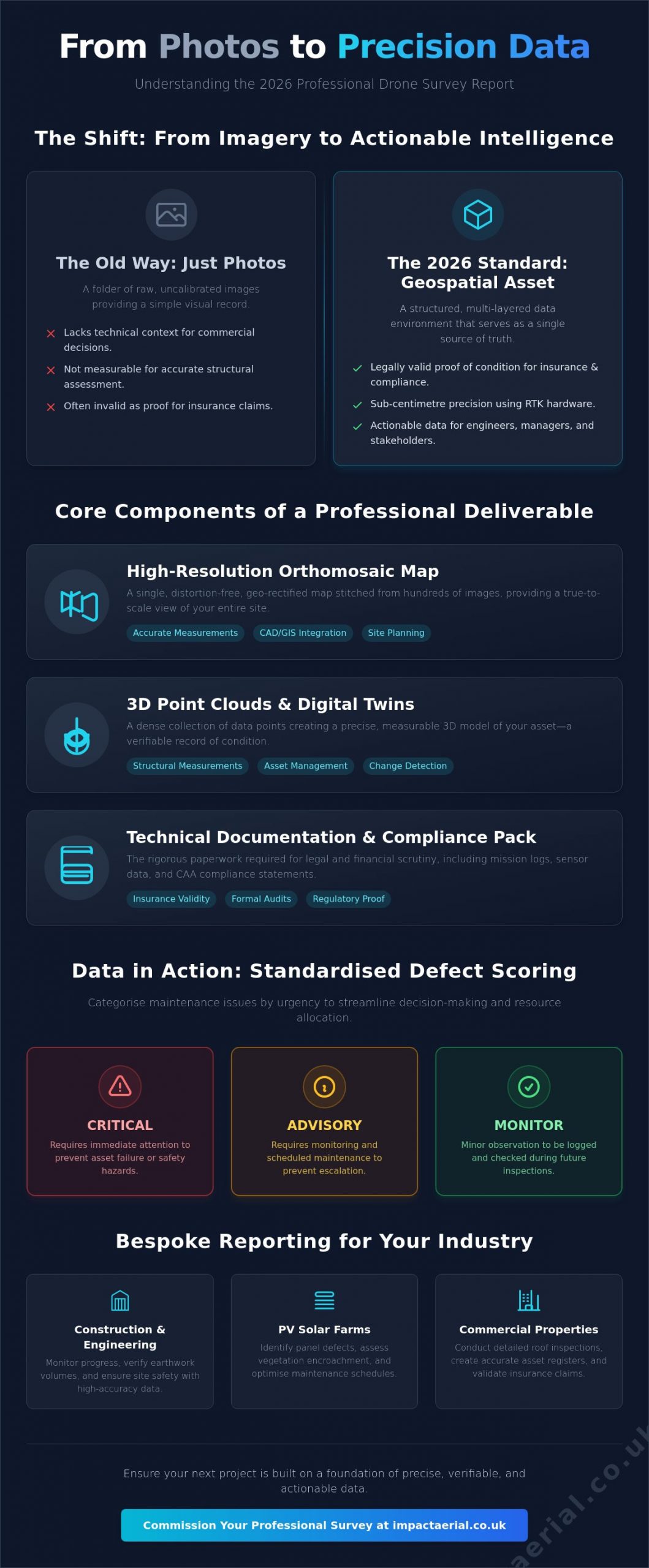
Defect Analysis and Risk Categorisation Frameworks
Raw data provides the foundation, but professional interpretation provides the value. A report that merely lists observations without assessing their impact is incomplete. When facility managers ask what does a drone survey report include, the most critical component for their workflow is a standardised risk categorisation framework. This analytical layer ensures that every stakeholder, from the site foreman to the financial director, understands the urgency of every identified issue. Without this hierarchy, a survey is simply a collection of observations rather than a strategic maintenance tool.
A meticulous approach to defect analysis removes subjectivity from the process. Instead of vague descriptions, professional reports use precise technical language to describe structural anomalies. This level of detail is essential for maintaining a rigorous audit trail and ensuring that repair budgets are allocated where they are most needed. By categorising findings, we provide a clear roadmap for asset management that balances immediate safety concerns with long-term preventative care.
The Traffic Light System for Building Maintenance
We utilise a clear, three-tier traffic light system to communicate risk levels instantly. This methodology allows for rapid decision-making without requiring the reader to parse through technical data for every minor finding. The categories are defined as follows:
- Red (Critical): These findings require immediate action. They represent active leaks, significant structural compromises, or immediate safety hazards that could lead to further damage or legal liability.
- Amber (Monitor): These defects show signs of deterioration that don’t yet pose a critical risk. They are scheduled for upcoming maintenance cycles or monitored closely to prevent them from escalating into Red-tier issues.
- Green (Maintenance): These areas are in good condition. They are documented to provide a baseline for future surveys, ensuring that routine maintenance can be tracked over time.
Geotagged Annotations and High-Resolution Crops
Precision is the hallmark of a professional survey. Every defect identified in the report is linked to its exact GPS coordinate through geotagged annotations. This eliminates the guesswork often associated with traditional roof inspections. When a contractor receives the report, they know the exact tile, bolt, or solar cell that requires attention. This spatial accuracy is supported by high-resolution “crops.” These are zoomed-in views of specific defects that provide granular detail, such as the hairline width of a crack or the specific type of corrosion on a bracket, without losing the broader context of the surrounding structure. This combination of “where” and “what” ensures that maintenance teams arrive on-site fully prepared for the specific task at hand.
Leveraging Your Report for Insurance and Compliance
A professional survey report isn’t just a technical document; it’s a legal safeguard. When evaluating what does a drone survey report include, the inclusion of regulatory documentation is often the difference between a valid claim and a rejected one. Insurers and regulatory bodies require more than just visual evidence. They demand proof that the data was collected safely, legally, and to a specific professional standard. By providing a comprehensive data package, you ensure that your asset management is backed by an unshakeable audit trail.
A drone survey report provides the objective evidence required to satisfy Health and Safety Executive (HSE) requirements by removing the need for high-altitude manual inspections. This reduces your operational risk profile. Integrating these reports into Planned Preventative Maintenance (PPM) schedules ensures that your asset management is data-driven rather than reactive. If you need to secure your asset’s future with a data-rich audit trail, you can book a compliant drone commercial property survey today.
CAA GVC Compliance and Operational Safety
The validity of your survey data starts before the drone even leaves the ground. Only CAA GVC certified pilots possess the legal authority to provide commercial data that holds weight in a professional or legal setting. A professional report package must include detailed flight logs, site-specific risk assessments, and proof of valid commercial insurance. These documents demonstrate that the mission adhered to current UK aviation and data privacy laws. In 2026, this includes verification of UK class marks and Remote ID compliance, ensuring the operation was conducted within the strictest safety parameters. Without this administrative backing, your survey data may be legally inadmissible for insurance or planning purposes.
Winning the Insurance Argument with Data
Insurance claims often hinge on the ability to distinguish between sudden storm damage and gradual wear-and-tear. A professional report provides timestamped, high-resolution “proof of condition” that serves as an objective baseline. This level of detail supports the RICS standards for building surveys, giving loss adjusters the precise data they need to process claims quickly. Regular, documented inspections can even help in negotiating lower insurance premiums. You aren’t just presenting a few photos; you’re presenting a multi-year history of the asset’s health. This proactive approach shows insurers that the property is being managed with professional meticulousness, significantly reducing the likelihood of disputed claims or unforeseen liabilities.
Commissioning Your Report with Impact Aerial
Choosing a partner for aerial data collection requires a focus on technical precision and operational safety. Understanding what does a drone survey report include is vital, but ensuring that data is captured using commercial-grade hardware is what guarantees a professional result. At Impact Aerial, we bridge the gap between raw aerial footage and high-tier geospatial assets. Our operations are backed by £5m in commercial liability insurance, providing the psychological comfort and financial security that large-scale property and construction projects demand. We don’t just provide images; we deliver a vetted, compliant, and meticulous data package designed for professional scrutiny.
Our workflow is structured and methodical. It begins with rigorous pre-flight planning and site-specific risk assessments, ensuring every mission adheres to the latest CAA regulations. Whether we are conducting PV solar farm thermal surveys or construction site monitoring, the focus remains on data integrity and safety. This meticulousness extends through the entire flight operation to the final delivery of your report, ensuring you receive a document that is both legally valid and technically superior.
Our Commercial-Grade DJI Enterprise Workflow
We utilise the latest DJI Enterprise technology, including the Matrice 350 RTK and Mavic 3 Enterprise, to ensure maximum data clarity. These platforms allow us to capture 4K HDR visual imagery alongside high-resolution radiometric thermal data. Our post-production team then refines this raw information into actionable insights. We don’t simply hand over a folder of files. We process the data into various formats to suit your specific needs, including cloud-based interactive portals, CAD-ready files for engineering teams, and concise PDF executive summaries for stakeholders. This multi-format approach ensures that the survey data is accessible to everyone from the site office to the boardroom.
Tailored Deliverables for UK Professionals
Every sector has unique requirements. We customise our reporting frameworks to meet the specific needs of West Midlands property managers while maintaining the capacity to handle nationwide projects. For a comprehensive look at the collection process, you can explore our drone survey guide. We provide bespoke reporting for property, construction, and solar sectors, ensuring that the final deliverable aligns with your internal compliance standards. If you are ready to move beyond simple photography and require a report that provides genuine commercial value, contact us to request a sample report or to discuss your upcoming project requirements. Our team is ready to provide the technical consultancy needed to transform your asset management strategy.
Securing Your Asset’s Future with Professional Aerial Intelligence
A professional survey deliverable is a high-accuracy geospatial asset that provides the technical foundation for long-term property management. By moving beyond simple imagery, you gain access to 3D point clouds, digital twins, and centimetre-accurate orthomosaic maps. These components ensure your decision-making is based on verifiable data rather than visual estimation. Understanding what does a drone survey report include allows you to demand higher standards, ensuring every defect is geotagged and every risk is categorised for immediate action.
Choosing a partner with CAA GVC Certified Pilots and £5m commercial liability insurance ensures your data meets the strictest regulatory and insurance requirements. We utilize DJI Enterprise grade hardware to deliver the precision your commercial property or construction project deserves. You don’t have to settle for vague photos when you can have a structured, data-rich audit trail. Request a sample drone survey report and a custom quote from Impact Aerial to see the difference professional data makes. We look forward to helping you streamline your maintenance workflows with meticulous aerial intelligence.
Frequently Asked Questions
Is a drone survey report legally valid for building insurance claims?
Yes, a drone survey report is considered legally valid evidence for insurance claims when produced by a CAA-certified pilot. It provides an objective, timestamped record of a property’s condition, which is essential for distinguishing between sudden storm damage and long-term wear. Insurers value this high-resolution data because it removes the subjectivity often found in manual inspections, ensuring that claims are processed based on verifiable structural facts.
What file formats are usually included in a drone survey deliverable?
Professional deliverables typically include a combination of accessible PDF summaries and technical data files for engineering use. You will usually receive high-resolution JPEG crops of specific defects, GeoTIFF files for orthomosaic maps, and .OBJ or .LAS files for 3D point clouds. These formats ensure that the data is ready for immediate review in a web browser or for direct integration into professional CAD and GIS software suites.
How long does it take to receive the final report after the flight?
Most professional reports are delivered within three to five working days following the completion of the flight operation. This duration is necessary for the meticulous processing of raw photogrammetry data and the subsequent analysis by technical experts. While visual previews can sometimes be provided sooner, the full analytical report requires this time to ensure sub-centimetre accuracy and the correct categorisation of all identified structural risks.
Can a drone survey report replace a traditional RICS building survey?
A drone survey report acts as a powerful data-gathering supplement rather than a total replacement for a traditional RICS survey. It provides superior external detail and access to hazardous areas that a ground-based surveyor cannot reach safely. Most property professionals use our aerial data to inform their RICS reports, combining our high-resolution external evidence with their own internal structural assessments for a complete building overview.
Do I need a special software to view the 3D models or orthomosaic maps?
You don’t need specialised software to view the primary results, as we typically deliver data through secure, cloud-based interactive portals. These platforms allow you to rotate 3D models and zoom into high-detail maps using a standard web browser. However, if your technical team needs to perform advanced volumetric calculations or CAD design, they will require industry-standard software like AutoCAD, Revit, or ArcGIS to process the raw data files.
What is the difference between a roof inspection and a full drone survey report?
A roof inspection is generally a visual-only exercise, while a full survey provides a measurable, multi-layered geospatial record. When considering what does a drone survey report include, the distinction lies in the data-centric outputs like 3D models and digital twins. A full report allows you to take precise measurements and track structural changes over time, offering a much deeper level of intelligence than a standard set of inspection photos.
Are drone survey reports compliant with UK CAA regulations?
Reports are only compliant when the mission is conducted by a pilot holding the correct CAA certifications, such as the GVC. A professional report includes the necessary flight logs, risk assessments, and insurance details to prove the operation met all UK aviation and data privacy laws. In 2026, this also includes verification that the hardware used meets the latest Remote ID and UK-specific class mark requirements for commercial operations.
