
What if the “affordable” drone pilot you just booked doesn’t actually have the legal right to fly near your commercial premises? You’re likely aware that high-resolution aerial data is no longer a luxury; it’s a competitive necessity for everything from construction site monitoring to PV solar farm thermal surveys. However, with the 2026 UK drone regulations now in full effect, the gap between a hobbyist and a certified expert has never been wider. It’s why more businesses now choose to hire professional drone photographer services that prioritize technical precision and risk mitigation over basic flight.
You shouldn’t have to worry about legal liability for non-compliant flights or hidden post-production costs that blow your budget. This guide will show you exactly how to secure 4K HDR imagery while ensuring total CAA compliance, including the latest Remote ID and UK class marking requirements. We’ll explore the critical steps to seamless project management, from initial flight planning and mandatory night-flying green lights to the final post-production edit. Discover how to leverage professional aerial filming and photography to gain a clear, compliant, and technically superior perspective on your next commercial project.
Key Takeaways
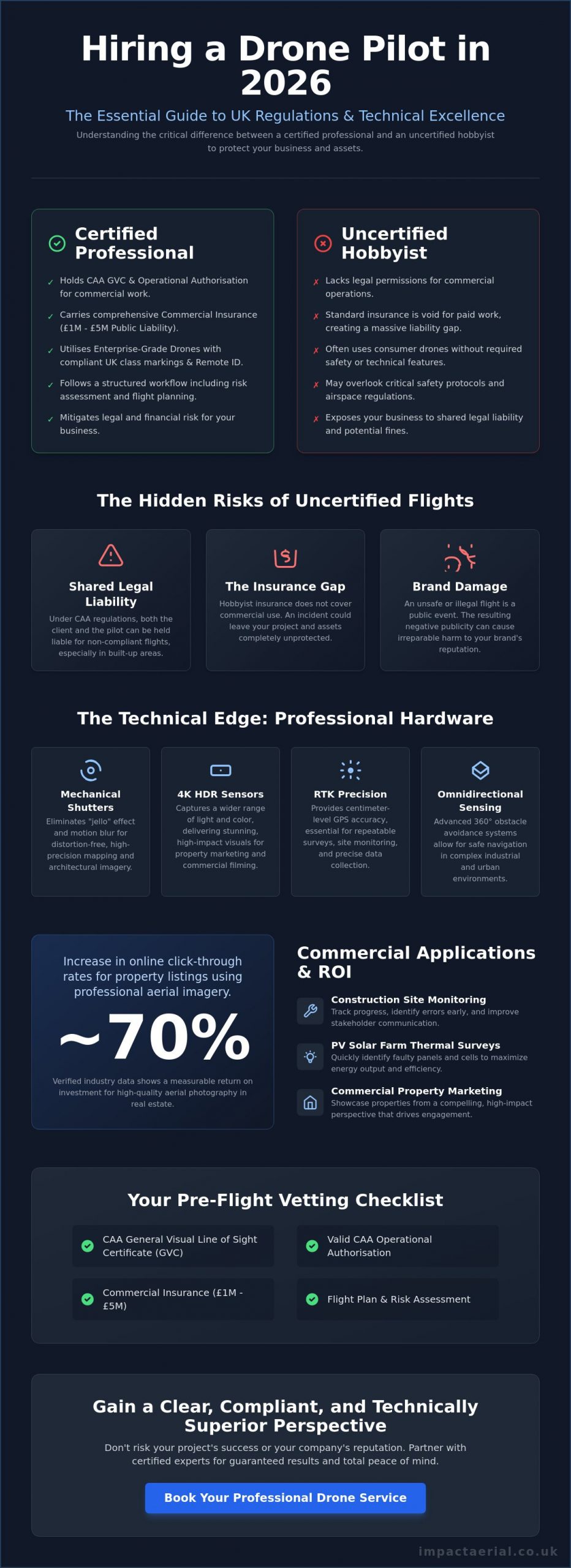
- Understand the critical legal distinction between hobbyist flights and commercial operations to protect your business from shared liability under 2026 UK regulations.
- Learn why enterprise-grade hardware featuring mechanical shutters and 4K HDR sensors is mandatory for high-precision technical surveys and commercial property marketing.
- Use our professional checklist to verify a pilot’s CAA GVC status and Operational Authorisation before you hire professional drone photographer experts for complex urban projects.
- Explore how specialized aerial data, from PV solar farm thermal surveys to construction site monitoring, provides measurable ROI and technical clarity for stakeholders.
- Discover the importance of a structured workflow that integrates meticulous flight planning with high-tier post-production services for a seamless project delivery.
Why Hiring a Professional Drone Photographer is Essential in 2026
The decision to hire professional drone photographer services is no longer just about capturing a unique angle; it’s a fundamental requirement for corporate risk management. In 2026, the distinction between a hobbyist and a commercial operator is defined by strict regulatory compliance and technical capability. While the history of aerial photography began with tethered balloons and rudimentary cameras, modern operations involve sophisticated systems like Remote ID and UK class markings. These technical layers ensure that every flight is accountable to the Civil Aviation Authority (CAA), providing a level of transparency and safety that hobbyist flights simply can’t match.
To better understand the visual impact of professional aerial work, watch this helpful video:
Commercial projects carry inherent risks that a casual pilot isn’t equipped to handle. Since January 1, 2026, all new drones must carry specific UK class markings, from UK0 to UK6, which dictate where they can fly and their proximity to the public. If you hire professional drone photographer experts who use “legacy drones” without the proper Operational Authorisation for urban areas, you aren’t just risking poor results. You’re assuming legal risk. The CAA can hold both the pilot and the client liable for non-compliant flights, particularly in built-up areas where safety protocols are paramount.
The Hidden Risks of Using Uncertified Operators
Uncertified operators often lack the specific insurance required for commercial work. Standard hobbyist policies fail when a drone is used for financial gain, leaving a massive “insurance gap” if an incident occurs. Professional operators carry public liability coverage, often ranging from £1 million to £5 million, to protect your assets and your reputation. Beyond the legal threat, an unsafe flight can cause irreparable damage to your brand’s public image. Meticulous planning is the only way to mitigate these operational dangers.
The Commercial Advantage of Professional Perspectives
Professional aerial filming and photography provide a measurable return on investment. High-resolution 4K HDR imagery can increase online click-through rates for property listings by nearly 70% based on verified industry data. In the industrial sector, construction site monitoring allows project managers to track progress with high precision, potentially shortening project timelines by identifying errors early. The psychological impact of high-end visuals is undeniable. They signal to your clients that you value quality, safety, and technical excellence.
The Technical Edge: What Separates Pro Drone Services from Hobbyists
Technical superiority isn’t just a marketing claim; it’s the foundation of every successful aerial project. When you hire professional drone photographer specialists, you’re paying for enterprise-grade hardware that far exceeds the capabilities of standard consumer models. For example, the DJI Mavic 3 Enterprise series features mechanical shutters. These are essential for eliminating rolling shutter distortion when capturing high-speed architectural data or mapping large sites. Consumer drones often rely on electronic shutters, which can lead to warped imagery that doesn’t meet rigorous technical standards.
Professional equipment provides several critical advantages for commercial clients:
- Mechanical Shutters: Prevents image “jello” effect during high-speed motion, ensuring crisp architectural lines.
- RTK Precision: Real-Time Kinematic positioning provides centimeter-level accuracy for repeatable site monitoring.
- Omnidirectional Sensing: Advanced obstacle avoidance allows for safe navigation in complex industrial environments.
- Dual-Sensor Payloads: The ability to switch between high-resolution visual and radiometric thermal data on a single flight.
Reliability in the field is equally dependent on flight stability. Professional systems utilize RTK positioning to achieve a level of precision that consumer GPS simply cannot match. This accuracy is critical for repeatable construction site monitoring where images must be captured from the exact same coordinates over several months. Furthermore, these systems operate within the strict safety parameters defined by Civil Aviation Authority (CAA) regulations, ensuring that every flight is both stable and legally compliant.
Commercial-Grade DJI Enterprise Technology
High-resolution 4K HDR sensors are standard for capturing the fine architectural details required in high-end property marketing. However, the true value of enterprise technology lies in specialized applications. For instance, PV solar farm thermal surveys require radiometric thermal cameras to detect micro-cracks and cell failures that are invisible to the naked eye. These enterprise drones also boast superior wind resistance and signal stability, allowing for successful operations in weather conditions that would ground a hobbyist aircraft.
The Professional Project Lifecycle
Managing the lifecycle of a commercial project requires more than basic flight skills. When businesses hire professional drone photographer teams, they’re investing in a structured workflow that prioritizes safety and data integrity. This begins with rigorous pre-flight site assessments and airspace coordination. Once the data is captured, the work transitions to our post-production services. Editing accounts for approximately 50% of the final product quality, transforming raw data into cinematic video or 3D models. If you require a technical partner rather than just a pilot, explore our drone commercial property surveys for comprehensive data delivery.
Commercial Applications: From Property Marketing to Technical Surveys
The decision to hire professional drone photographer teams often moves beyond aesthetic appeal into the realm of actionable business intelligence. While the hardware discussed previously provides the foundation, the true value lies in how this technology integrates into specific industry workflows. From high-end residential marketing to complex industrial inspections, professional aerial services offer a level of detail and safety that ground-based methods cannot replicate. Adhering to UK Civil Aviation Authority drone regulations is mandatory for these commercial applications, ensuring that data collection doesn’t compromise public safety or legal standing.
Real Estate and Property Development
In the competitive UK property market, high-resolution imagery is essential for contextualising a building within its wider landscape. Professional pilots capture cinematic “hero shots” that highlight proximity to local infrastructure, green spaces, and transport links. This goes beyond simple photography; it includes creating immersive virtual tours that allow luxury listings to stand out to international investors. For commercial developers, these perspectives are vital for site planning and showcasing the scale of a project to stakeholders before the first brick is laid.
Technical Data and Construction Surveys
Construction site monitoring has been transformed by the ability to track progress from the air over time. Regular aerial flyovers provide project managers with a chronological record of development, helping to identify potential delays or logistical bottlenecks. Using drones for commercial property surveys allows for the identification of structural issues in high-access areas, such as church spires, chimneys, or expansive warehouse roofs, without the need for expensive scaffolding or risky manual inspections.
Industrial inspections also benefit from specialized sensors. Thermal analysis is increasingly used to assess energy efficiency by identifying heat loss in commercial buildings or detecting faults in PV solar arrays. This data-centric approach ensures that maintenance teams can target specific problem areas, reducing operational costs and downtime. In creative advertising, these same technical skills are used to capture sweeping, high-tier visuals for brand campaigns, proving that a meticulous, compliant approach to flight is the key to unlocking both creative and technical success.
The Professional Checklist: How to Vet Your Drone Pilot
Choosing to hire professional drone photographer services requires a shift in mindset from creative procurement to technical vetting. In 2026, the regulatory environment is too complex for casual hires based on a flashy Instagram feed alone. You need a verifiable paper trail that proves competence, legal standing, and operational safety. Vetting is your primary tool for risk management, ensuring that your commercial project remains compliant with national aviation standards while delivering high-tier data.
Understanding CAA Certifications in 2026
The foundational requirement for any commercial operator is their specific certification. While an A2 Certificate of Competence (A2 CofC) allows for basic flights in lower-risk environments, a General Visual Line of Sight Certificate (GVC) is the hallmark of a true professional. A GVC pilot has undergone rigorous practical assessments and is qualified to handle more complex operations. This certification is a prerequisite for obtaining an Operational Authorisation from the CAA, which is mandatory for flights in built-up urban areas or near uninvolved people. A valid UK drone license is non-negotiable; always verify a pilot’s credentials against the official CAA register before signing a contract.
Insurance and Risk Mitigation
Insurance is where uncertified operators frequently fail. Standard public liability policies often specifically exclude aviation activities or contain restrictive clauses that void coverage during commercial work. Professional operators maintain insurance that is strictly compliant with EC 785/2004 regulations. While some entry-level pilots carry £1 million in coverage, the industry gold standard for high-stakes commercial projects is £5 million. This level of protection ensures your business is shielded from significant financial loss in the event of hardware failure or accidental property damage.
Beyond the insurance certificate, a meticulous pilot will provide a comprehensive Risk Assessment and Method Statement (RAMS). This document should detail:
- Site-specific hazard identification and mitigation strategies.
- Emergency procedures and “lost link” protocols.
- Airspace coordination and local authority permissions.
- Specific hardware and software versions used for the mission.
Finally, examine a recent portfolio for technical consistency rather than just a few “lucky” shots. Look for crisp imagery across the entire frame and balanced exposure in challenging lighting conditions. Professional work should show no signs of rolling shutter distortion or pixelation in 4K HDR outputs. If you are ready to secure a fully vetted and insured partner for your next project, contact us for high-precision aerial filming and photography services across the UK.
Impact Aerial: Your Partner for Precision Drone Photography in the UK
Impact Aerial operates as a specialized technical consultancy rather than a standard creative agency. Based in Birmingham and serving the entire United Kingdom, we provide national coverage for organizations that require absolute regulatory compliance and high-tier visual data. When you decide to hire professional drone photographer specialists, you’re choosing a partner that understands the nuances of the 2026 UK aviation landscape. We don’t just fly; we manage complex aerial operations that prioritize data integrity and site safety.
Our commitment to excellence is reflected in our hardware choices and insurance standards. We utilize the latest DJI Enterprise drone technology, ensuring every mission benefits from RTK precision and high-resolution 4K HDR sensors. This technical foundation is backed by £5 million in commercial liability insurance, which is the industry gold standard for professional operators. This level of coverage provides the reassurance needed when operating near sensitive infrastructure or high-value commercial property. It’s a level of protection that consumer-level pilots simply cannot offer.
The Impact Aerial Difference
Our methodology is built on meticulous planning and adherence to safety-first protocols. Every project begins with a detailed site assessment and airspace coordination, ensuring that all flights are fully compliant with current CAA standards. We offer bespoke solutions tailored to the property, construction, and advertising sectors, providing a seamless transition from raw data capture to final delivery. Our in-house post-production services ensure that the final imagery or 3D models are polished, precise, and ready for stakeholder review. This includes technical color grading for cinematic video and the careful stitching of high-resolution stills for expansive drone commercial property surveys.
Get Started with Your Aerial Project
We provide a structured project lifecycle that values your time and project deadlines. From the initial consultation, we work to understand your specific data requirements, whether you need construction site monitoring or sophisticated virtual tour creation. Our team handles all necessary local permissions and risk assessments, removing the administrative burden from your internal staff. This allows your team to focus on the insights our data provides rather than the logistics of the flight itself.
Our typical project timeline is designed for efficiency, moving from the site flight to the final edit with transparent communication at every stage. We provide tailored quotes that reflect the technical complexity and scale of your mission. Hire Impact Aerial for your professional drone photography today to secure a compliant, expert partner for your next UK aerial project. We’re ready to deliver the high-precision imagery your commercial project demands.
Future-Proof Your Operations with Professional Aerial Intelligence
The landscape of UK aerial services has shifted toward a more structured and accountable model. Choosing to hire professional drone photographer experts ensures your projects benefit from 2026-compliant technology and meticulous risk management. You gain more than just a visual perspective; you secure data accuracy and legal protection that hobbyist operations cannot provide. Whether it’s for PV solar farm thermal surveys or construction site monitoring, the technical requirements of modern industry demand a specialist approach.
Impact Aerial provides the technical edge your business requires. Our CAA GVC Certified Pilots use the latest DJI Enterprise Hardware to deliver high-resolution results across the UK. With £5m Commercial Liability Insurance and specialized Birmingham-based national coverage, we offer the reliability needed for complex commercial missions. We’re proud of our track record in delivering high-precision data that supports informed decision-making.
Book Your Professional Drone Photography Consultation Today to discuss your specific requirements for technical surveys or high-end property marketing. We look forward to helping you achieve a superior perspective on your next project.
Frequently Asked Questions
How much does it cost to hire a professional drone photographer in the UK?
Pricing for aerial services depends on project complexity, location, and the specific technical requirements of the mission. Factors such as the use of specialized thermal sensors for PV solar farm surveys or the need for high-resolution 4K HDR imagery for property marketing will influence the final investment. Most professional operators provide bespoke quotes after an initial consultation to account for airspace coordination and post-production editing needs.
Do I need to get permission from my neighbours for drone photography?
You don’t strictly require permission from neighbours to fly over their property, but you must adhere to privacy laws and Civil Aviation Authority (CAA) regulations. Professional pilots ensure they don’t capture identifiable images of people or private data without consent, following the Data Protection Act 2018. When you hire professional drone photographer services, the pilot conducts a thorough risk assessment to ensure all flights remain respectful and legally compliant.
What happens if the weather is bad on the day of the drone shoot?
Professional pilots monitor weather conditions meticulously and will reschedule if wind speeds or precipitation exceed the safe operating limits of the hardware. Enterprise-grade drones generally have higher wind resistance than consumer models, but operational safety remains the absolute priority. Most professional operators include a weather clause in their agreements to allow for a flexible rescheduling window without financial penalty to the client.
Is it legal to fly drones in London or other major UK cities?
It is legal to fly in major cities, but it requires specific certifications and often an Operational Authorisation from the CAA. Flying in congested urban areas like London involves navigating restricted airspace and maintaining safe distances from uninvolved persons. Professional operators manage all necessary permissions and coordination with local authorities to ensure every urban flight is fully authorized and insured for your peace of mind.
How long does a typical professional drone photography session take?
A standard on-site session usually lasts between one and three hours, depending on the scope of the project. Simple property shots might be completed quickly, while comprehensive construction site monitoring or large-scale commercial property surveys require more time for systematic data capture. This timeframe excludes the essential pre-flight planning and the extensive post-production editing required to deliver high-tier professional assets.
What file formats will I receive for my aerial photos and videos?
Clients typically receive high-resolution JPEG or TIFF files for photography and MP4 or MOV files for video production. For technical projects, we can provide specialized data formats such as RAW files for advanced editing or radiometric thermal data for solar inspections. We ensure all deliverables are compatible with your existing marketing or project management software during the final post-production phase.
Can drones be used for indoor photography or filming?
Drones are highly effective for indoor use provided the space is sufficiently large and the pilot uses aircraft equipped with omnidirectional obstacle avoidance. Indoor filming is ideal for showcasing expansive warehouse interiors or large commercial developments. These flights require exceptional pilot skill and specific safety protocols because GPS signals are often unavailable or unreliable inside large structures.
What is the maximum height a professional drone can fly in the UK?
The legal height limit for drone operations in the UK is 120 meters, which is approximately 400 feet above the earth’s surface. This limit is strictly enforced by the Civil Aviation Authority to prevent conflicts with manned aircraft. If a specific commercial project requires a higher altitude, the operator must apply for a specific exemption or an enhanced Operational Authorisation involving additional safety coordination.
 2 Norton Drive, Wythall, Birmingham, B47 6HH Company registration number: 11138586. VAT Number: 366 9068 55


