
Drone Survey Manchester: Professional Aerial Inspections & Data Collection

Why would a property manager risk the liability and high cost of traditional scaffolding when a drone survey manchester can capture superior data in a single afternoon? It’s a question more Manchester businesses are asking as they face the dual challenges of aging infrastructure and some of the most complex urban airspace in the UK. You’re likely already aware that manual roof inspections aren’t just slow; they’re inherently dangerous and often fail to provide the granular detail needed for modern asset management.

We understand that navigating the strict flight restrictions around Manchester Airport or HMP Manchester feels like a bureaucratic hurdle that’s often easier to avoid. This guide shows how professional aerial inspections provide a safer, faster, and more accurate alternative to traditional methods. You’ll discover how the combination of CAA GVC certified pilots and DJI Enterprise hardware delivers high-resolution 4K imagery with minimal operational downtime. We’ll also explain the essential compliance standards, including £5m commercial liability insurance, required to operate safely and legally within the city’s unique environment.

Key Takeaways

  • Aerial inspections significantly reduce operational downtime and costs compared to traditional scaffolding, making them ideal for Manchester’s dense urban environments.
  • Learn how to navigate the complex legal requirements of a drone survey manchester, including the specific flight permissions needed for areas near Manchester Airport.
  • High-resolution 4K data and thermal imaging offer superior accuracy for identifying structural defects or heat loss in both heritage mills and modern skyscrapers.
  • Discover how utilizing CAA certified pilots and professional-grade hardware eliminates the safety risks associated with manual ‘work at height’ inspections.
  • Gain insights into the specialized deliverables available for Manchester property managers, ranging from warehouse roof surveys to comprehensive solar farm thermal reports.

Why Drone Surveys are Essential for Manchester’s Property Sector

Manchester’s skyline is a testament to its evolution; it’s a place where red-brick Victorian mills sit alongside the sleek glass of modern skyscrapers. This architectural diversity creates a complex environment for property inspections. A professional drone survey manchester offers the most efficient way to bridge the gap between these different eras of construction. By utilizing commercial-grade DJI Enterprise drones, we provide a perspective that traditional ground-based surveys simply can’t match.

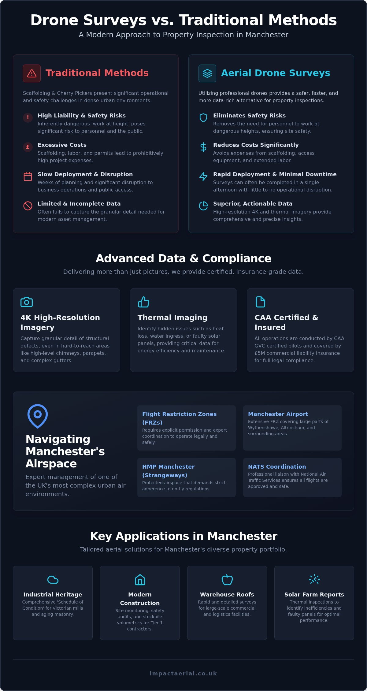
Traditional access methods like scaffolding or cherry pickers are often impractical in dense urban areas like Spinningfields or the Northern Quarter. The logistical planning required to block a busy city-centre pavement can take weeks and cost thousands before an inspection even begins. Aerial data collection eliminates this friction, allowing for rapid deployment and minimal disruption to daily business operations. To provide a technical foundation for these techniques, it helps to define the process. What is an aerial survey? It is the science of collecting precise georeferenced data from an airborne platform, which is exactly what we provide for Manchester’s commercial sector.

To better understand how this technology maps the local landscape, watch this helpful video:

Inspecting Manchester’s Industrial Heritage

Manchester’s history is written in its industrial masonry. However, surveying these aging structures presents significant safety risks and technical challenges. Hidden defects in high-level chimneys, parapets, and complex valley gutters are often impossible to see from street level. We use high-resolution 4K HDR imagery to create a comprehensive ‘Schedule of Condition’ for these heritage assets. This allows owners to identify structural issues early, providing insurance-grade data without the need for personnel to work at dangerous heights.

Supporting Modern Construction in Greater Manchester

The pace of residential and commercial development in the city centre is relentless. Tier 1 contractors now rely on construction site monitoring to keep projects on track. A drone survey manchester can provide weekly progress updates, site safety audits, and highly accurate stockpile volumetrics. This level of data-centric oversight ensures that large-scale projects across Greater Manchester remain compliant and efficient. Our CAA GVC certified pilots navigate these high-rise environments with precision, delivering the qualitative output needed for modern Building Information Modeling (BIM) workflows.

A professional drone survey manchester is a CAA-regulated operation that demands more than technical skill; it requires a meticulous approach to aviation law. Manchester’s airspace is some of the most congested in the North West. Every commercial flight must adhere to the latest Civil Aviation Authority drone rules to ensure the safety of the public and other aircraft. Operating without these legal frameworks in place puts both the operator and the client at significant legal and financial risk.

The city is home to several complex Flight Restriction Zones (FRZs) that require expert navigation. Manchester Airport’s FRZ extends significantly into the surrounding residential and commercial areas, including parts of Wythenshawe and Altrincham. Furthermore, HMP Manchester (Strangeways) has its own protected airspace that must be respected at all times. Operating within these zones without explicit permission is illegal and can result in severe penalties. Professional operators manage these complexities through formal coordination with National Air Traffic Services (NATS) and the airport’s control tower well in advance of the flight date.

Securing Permissions in Restricted Zones

Coordination is a critical component of safety. For projects in busy urban hubs, we often coordinate with the Greater Manchester Police and Manchester City Council. Filing a NOTAM (Notice to Airmen) is a standard part of our pre-flight process; it alerts other aviators to our presence in the area. Risk mitigation in the city centre involves more than just mapping flight paths. It requires a detailed understanding of potential signal interference from skyscrapers and managing pedestrian flow on busy thoroughfares like Deansgate or Cross Street to ensure a sterile take-off and landing zone.

The Importance of Certified Pilots

Hobbyist pilots are legally prohibited from performing commercial work in the UK. In complex urban environments, the technical requirements for pilots are even higher. While an A2 CofC (Certificate of Competence) allows for basic operations, the GVC (General Visual Line of Sight Certificate) is the industry standard for professional urban surveys. This certification demonstrates a superior level of pilot training, operational safety, and risk assessment. You can understand the UK drone license requirements more deeply in our simple guide to the 2026 rules.

Finally, insurance is a non-negotiable factor for any commercial project. Standard consumer policies don’t cover commercial property damage or public liability in a high-density city-centre setting. We maintain £5m in commercial liability insurance, providing the reassurance and reliability our clients expect when we operate near their high-value assets. If you have concerns about site-specific restrictions, our team can provide a pre-flight feasibility assessment to ensure your project is fully compliant and insured.
Drone Survey Manchester: Professional Aerial Inspections & Data Collection

Comparing Drone Surveys to Traditional Access Methods

For many property managers, the decision between traditional access and aerial data collection comes down to a simple calculation of speed and risk. A professional drone survey manchester can be completed in a matter of hours, whereas erecting scaffolding for a similar inspection can take days or even weeks of logistical planning. This rapid turnaround doesn’t just save time; it allows for a more agile approach to building maintenance where issues are identified and resolved before they escalate into costly structural failures.

The difference in data resolution is equally stark. Ground-based inspections or surveys conducted from ladders provide a limited, oblique view of a building’s upper reaches. Our DJI Enterprise drones capture high-resolution 4K imagery from vertical and top-down perspectives that are physically impossible to achieve from the ground. This provides a level of detail that allows surveyors to zoom in on individual brick ties, mortar joints, or hairline cracks in chimney stacks with absolute clarity.

Scaffolding vs. Drone Inspections

Scaffolding, while once the only viable option for high-level work, carries significant hidden costs that go beyond the initial hire fee. In Manchester’s city centre, you have to account for pavement licenses, local authority permits, and the potential for building downtime. There’s also the security risk of leaving a climbing frame attached to your property for weeks. A drone survey manchester bypasses these hurdles entirely. We can access difficult areas like internal courtyards and deep valley gutters that would be prohibitively expensive to reach with traditional platforms. Additionally, drone operations are zero-emission, offering a more sustainable alternative to the heavy machinery and transport required for large-scale scaffolding projects.

Safety and Risk Mitigation

Safety remains the most compelling reason to choose aerial inspections. Removing the need for personnel to work at height significantly reduces the risk profile of any construction or maintenance site. Since falls from height are a leading cause of workplace injuries in the UK, eliminating this requirement provides immediate psychological comfort and tangible liability reduction for site owners. Our thermal imaging capabilities add another layer of safety by identifying dampness or heat loss without the need for invasive testing. You can see our guide to drone inspections for a deeper technical breakdown of how we use these advanced sensors to protect your assets and your workforce. By choosing a provider with £5m commercial liability insurance and CAA GVC certified pilots, you ensure that your survey is not only accurate but fully compliant with the highest industry standards.

Applications of Aerial Data Collection in Manchester

Energy efficiency is a primary concern for Greater Manchester’s ‘Green Building’ initiatives. We use DJI Enterprise thermal sensors to create high-accuracy heat-loss maps, helping property owners identify insulation gaps and structural thermal bridges. This technology is particularly effective for identifying issues with Reinforced Autoclaved Aerated Concrete (RAAC) in older public and commercial buildings, where thermal anomalies can indicate moisture ingress within the panels. Our specialized PV solar farm thermal surveys are another critical application. By detecting faulty cells that have overheated, we help operators maximize their return on investment and maintain peak performance across their renewable energy portfolios.

Post-Production and Data Analysis

The value of a professional drone survey manchester lies in what happens after the drone lands. Raw 4K footage is just a starting point; the real power comes from our post-production and data analysis pipeline. We transform thousands of individual images into high-resolution orthomosaic maps. These are georeferenced, 2D representations of a site that allow for precise measurements of area and distance with centimetre-level accuracy. For construction clients, this data can be integrated into Scan-to-BIM workflows, providing a digital twin of the project at specific points in time. Our specialists edit this raw data into actionable architectural reports, ensuring you have the qualitative evidence required for insurance claims or planning applications. If you’re ready to move from raw data to actionable insights, you can book a professional drone survey for your next project.

Choosing Impact Aerial for Your Manchester Drone Project

Selecting a partner for a drone survey manchester requires more than just looking at a portfolio of aerial photographs. It’s about choosing an operator who understands the gravity of industrial safety and the intricate requirements of urban aviation law. We’ve built our reputation on being a meticulous technical consultant rather than a flashy creative agency. Our focus remains on delivering the reassurance and reliability that commercial clients need when inspecting high-value property or monitoring multi-million pound construction sites across the North West. We treat every flight as a precision operation where data accuracy and regulatory compliance are the primary objectives.

Our Professional Standards

Our operations are underpinned by a commitment to the highest industry standards. Every pilot in our team is CAA GVC certified, which represents the gold standard for visual line of sight operations in congested urban areas. We don’t just show up and fly. Our process begins with a detailed feasibility study and a site-specific risk assessment that accounts for the unique challenges of the Manchester landscape. This meticulous planning is backed by £5m in commercial liability insurance, providing essential psychological comfort to asset managers and stakeholders. We utilize commercial-grade DJI Enterprise drones equipped with 4K HDR sensors and thermal imaging capabilities. These are high-precision industrial tools designed for data integrity. Our in-house post-production team then processes this raw data into the orthomosaic maps and architectural reports discussed earlier, ensuring a seamless end-to-end service from the initial consultation to final data delivery.

Get a Quote for Your Manchester Survey

Initiating your project is a straightforward and transparent process. When you contact us, we’ll discuss your specific site location and survey objectives to determine the most effective flight plan and sensor choice. Whether you need a detailed condition report for a warehouse in Trafford Park or a thermal inspection for a renewable energy asset, we provide a clear roadmap for data collection. We believe in a transparent approach to project management. This means providing clear timelines for airspace permissions and being upfront about the risk assessment outcomes for flights near restricted zones like Manchester Airport. Our goal is to act as a technical extension of your team, providing the specialist knowledge required to operate safely in complex environments. We’re ready to help you unlock the benefits of aerial data for your next project. Contact Impact Aerial today for a professional drone survey quote.

Elevating Property Intelligence in Manchester

Manchester’s architectural landscape is evolving fast, and traditional inspection methods can’t keep pace with the efficiency and safety required for modern asset management. By choosing a professional drone survey manchester, you eliminate the inherent safety risks of working at height while gaining access to high-resolution 4K HDR data that ground-based teams simply can’t provide. We’ve explored how navigating the city’s complex flight restriction zones requires a meticulous approach to compliance and coordination with local authorities.

Our commitment to your project’s security is backed by CAA GVC certified pilots and £5m in commercial liability insurance. We use industrial DJI Enterprise hardware to ensure that every pixel of data is accurate and actionable for your architectural or maintenance reports. Whether you’re managing a heritage mill renovation or a high-rise construction project, we provide the technical expertise to deliver results without the logistical downtime of scaffolding.

Ready to optimize your property data? Request a Professional Drone Survey Quote for Manchester and take the first step toward a safer, more efficient inspection process. We look forward to supporting your next project with precision aerial insights.

Frequently Asked Questions

Is it legal to fly a drone for a survey in Manchester city centre?

Yes, it is entirely legal provided the operator holds the correct Civil Aviation Authority (CAA) certifications and operational authorizations. In a dense urban environment like Manchester, a professional pilot must hold a General Visual Line of Sight Certificate (GVC). This ensures the flight is conducted within a strict safety framework. We manage all necessary legal permissions to ensure your aerial inspection is fully compliant with UK aviation law.

What are the Flight Restriction Zones (FRZs) in Manchester?

The most significant Flight Restriction Zones in the region are Manchester Airport and HMP Manchester. The airport’s FRZ is particularly large, extending into several surrounding residential and commercial districts. Conducting a drone survey manchester within these areas requires formal coordination with National Air Traffic Services (NATS) and the airport’s air traffic control tower. We handle this complex bureaucratic process to secure the required flight windows safely.

How much does a drone survey in Manchester typically cost?

Project costs are determined by several variables, including the site’s location, the complexity of the airspace, and the specific data sensors required. A simple visual roof inspection has a different cost profile than a large-scale topographic map or a thermal solar farm survey. We provide bespoke, transparent quotes based on your specific survey objectives and data deliverables, ensuring you receive a professional service tailored to your budget.

Do you need permission from Manchester City Council for a drone flight?

Permission is generally required if the drone’s take-off or landing point is on council-owned land or a public thoroughfare. For flights over private property, the primary requirement is the consent of the landowner. As part of our meticulous planning process, we verify current Manchester City Council policies for 2026. This ensures all local bylaws are respected and that the operation causes zero disruption to the public.

How long does a typical drone roof survey take to complete?

A standard commercial roof survey usually takes between two and four hours on-site. This rapid turnaround is one of the primary benefits of aerial data collection compared to traditional scaffolding, which can take days to erect. The exact duration depends on the building’s footprint and architectural complexity. Our DJI Enterprise hardware allows for efficient data capture, ensuring we minimize our time on-site while maximizing the resolution of the imagery collected.

What insurance coverage is required for professional drone surveys?

Professional operators must hold specialist commercial drone liability insurance that meets EC 785/2004 standards. We maintain £5m in commercial liability insurance, which is the recognized industry standard for high-value urban projects. This level of coverage provides essential reassurance and reliability for asset managers. It ensures that your business is fully protected against third-party risks while we operate in the challenging environments of Manchester’s busy commercial districts.

Can drones perform inspections in bad weather like rain or high winds?

While industrial drones have high wind resistance and certain IP ratings for moisture, we prioritize data quality and safety. Heavy rain can obscure camera lenses and affect the accuracy of thermal sensors. If weather conditions exceed our strict safety parameters, we reschedule the flight to the next available clear window. This commitment to safety-first operations ensures that the data you receive is always of the highest professional standard.

What kind of data will I receive after the drone survey is finished?

You will receive a comprehensive data package tailored to your project. This typically includes high-resolution 4K HDR imagery and, where requested, specialized thermal heat-loss maps or georeferenced orthomosaic overlays. For construction clients, we provide data compatible with BIM workflows and precise site measurements. Our post-production team processes the raw data into an actionable architectural report, identifying structural defects or maintenance issues with high-tier precision and clarity.

Professional Property Drone Photography in Manchester: The Complete 2026 Guide

A drone hovering over a Deansgate development is more than just a camera; it’s a sophisticated piece of aeronautical equipment operating within one of the UK’s most complex air traffic zones. You likely understand that high-quality aerial perspectives are no longer a luxury but a necessity for competitive listings. However, the logistical hurdles of the Manchester Airport CTR and the unpredictable North West rain often make professional results feel like a gamble. Finding a pilot who is actually insured and GVC certified shouldn’t be the hardest part of your marketing strategy.

This guide explains how to secure property drone photography manchester that delivers breathtaking visuals and precise survey data while ensuring 100% CAA compliance. We’ll show you how professional imagery can increase listing engagement by up to 60 percent based on 2024 industry data. You’ll learn how to navigate restricted airspace, verify pilot credentials for added peace of mind, and utilize the latest 4K HDR technology to bypass the need for expensive scaffolding. We provide a clear roadmap for achieving stunning results regardless of the Manchester weather or complex local regulations.

Key Takeaways

  • Understand how professional property drone photography manchester transforms “Northern Powerhouse” developments by providing high-quality perspectives that elevate market listings.
  • Learn the critical importance of CAA GVC certification and how to navigate the Manchester Airport Flight Restricted Zone (FRZ) for compliant city centre operations.
  • Discover the distinct differences between residential lifestyle imagery and the technical, data-heavy requirements of commercial structural surveys.
  • Master the logistics of a North West shoot, including how to manage unpredictable weather patterns and essential pre-flight checklists for added peace of mind.
  • Explore why “Gold Standard” safety protocols and professional services are essential for delivering high-quality aerial data in complex urban environments.

The Impact of Property Drone Photography in Manchester’s Market

Professional property drone photography in Manchester has evolved from a luxury add-on into a critical data-gathering tool for the city’s real estate sector. While the history of aerial photography dates back to the 19th century, today’s 4K HDR DJI Enterprise drones provide a level of precision that was previously impossible. In 2026, Manchester’s “Northern Powerhouse” status demands high-quality visual assets to compete in a global market. It’s no longer enough to show a building’s facade; investors want to see the context of the entire district.

To better understand the visual scale these tools provide, watch this demonstration of professional aerial filming in the city:

Elevated angles do more than just look impressive; they create a psychological advantage by increasing a property’s perceived value. Data from UK property markets in 2024 indicated that listings featuring professional aerial shots sold 32% faster than those relying solely on ground-level images. By 2026, property drone photography manchester has transitioned from an optional feature to an industry standard for any development exceeding a £500,000 valuation. It provides a sense of prestige and scale that traditional tripod-mounted photography cannot replicate.

Transforming Manchester’s Skyline Listings

Manchester’s urban core is currently defined by the rapid expansion of high-rise residential towers in Deansgate and Ancoats. Drones allow agents to showcase a property’s proximity to key economic hubs like MediaCityUK, Salford Quays, and the Northern Quarter within a single frame. Capturing the scale of a 50-storey tower requires the technical expertise of CAA GVC Certified operators who can safely navigate congested city centre environments. This perspective highlights transport links and local amenities, proving the location’s value to potential buyers instantly.

Beyond Marketing: The Rise of Aerial Surveys

Beyond aesthetics, drone property surveys deliver rapid ROI for Manchester landlords and estate managers. Using thermal imaging and high-resolution zoom, specialists identify roof defects or heat leaks in industrial heritage buildings without the prohibitive expense of scaffolding. In 2025, city centre survey costs were reduced by an average of 60% when switching from traditional access methods to drone-based inspections. This provides peace of mind for commercial asset managers responsible for large portfolios across the region.

Flying drones in a major metropolitan hub requires more than technical skill; it demands strict adherence to UK Civil Aviation Authority drone regulations to ensure the safety of both property and the public. Manchester presents a unique challenge for property drone photography manchester due to the Manchester Airport Flight Restricted Zone (FRZ). This zone extends in a 5km radius from the airport, with additional 5km by 1km approach corridors that cover significant portions of South Manchester and Cheshire. Operating within these boundaries requires specific ATC (Air Traffic Control) clearance, a process our team manages entirely to provide clients with absolute peace of mind.

The Legal Framework for Manchester Drone Flights

Our pilots have transitioned from the older PfCO (Permission for Commercial Operation) to the current General Visual Line of Sight Certificate (GVC). This certification is essential for operating in the “canyons” of Deansgate or the Greengate area, where high-rise buildings create complex wind patterns and signal obstacles. Every mission begins with a site-specific risk assessment (RAMS) that details emergency landing zones and weather thresholds, ensuring a meticulous approach to every project. Under UK law, it’s a mandatory requirement for all commercial drone operators to hold valid EC 785/2004 compliant insurance. Our £5m commercial liability insurance covers every flight, protecting our clients from unforeseen liabilities in this niche but increasingly diverse market.

Managing Public Safety in Busy Urban Centres

Safety is our primary metric for success. In high-footfall areas such as Piccadilly Gardens or the Northern Quarter, we implement physical ground-level cordons to maintain a clear sterile area during takeoff and landing. This proactive management prevents unauthorized access to the flight controller’s immediate vicinity. Privacy is equally paramount; our post-processing workflows ensure GDPR compliance by blurring faces and vehicle registrations in residential neighborhoods.

To maintain control in the RF-heavy environment of the city centre, we utilise a DJI Enterprise fleet. These aircraft use O3+ transmission systems to ensure signal stability despite the massive radio frequency interference found in urban settings. This technology allows us to deliver the high-quality data-gathering services our clients expect without compromising on operational security. If you are planning a development project, you can contact our specialist team to review your site’s specific airspace requirements and ensure a compliant shoot.

Comparing Drone Services for Residential and Commercial Assets

Executing professional property drone photography manchester requires a tailored approach that shifts based on the asset class. Residential and commercial projects demand different flight altitudes, camera sensors, and data outputs. For residential listings, our focus remains on aesthetic appeal and lifestyle positioning. We capture high-end homes in areas like Didsbury or Altrincham during the “golden hour” to ensure the property looks inviting. High Dynamic Range (HDR) processing ensures that shadows are balanced and highlights don’t blow out, which is vital for premium estate agency marketing.

Commercial assets require a more technical perspective. Investors and facility managers in Manchester city centre prioritise site context and structural integrity over purely artistic shots. We provide wide-angle aerial views that show a building’s proximity to transport links like the M60 or Piccadilly Station. For industrial assets, particularly the massive warehouse footprints in Trafford Park, we deploy thermal imaging sensors. These specialised drones identify heat signatures that indicate roof leaks or insulation failures across 250,000 square foot facilities. This data-gathering capability provides a level of detail that traditional ground-based inspections cannot match.

Large-scale developments also benefit from recurring flight paths. By capturing consistent progress shots, stakeholders and investors track construction milestones against projected timelines. This provides a transparent record of work for professional services and ensures project accountability from breaking ground to completion.

Marketing Visuals vs. Technical Data

The choice of equipment depends on whether the goal is promotion or precision. For marketing, we utilise the DJI Mavic 3 Pro for its triple-camera system, delivering 4K HDR cinematic video that outperforms standard ground photography. However, for technical surveys, we use Enterprise models equipped with RTK (Real-Time Kinematic) modules for centimetre-level accuracy. While 3D virtual tours are excellent for interior walkthroughs, drone photography provides the essential external context. We often combine photogrammetric survey data with visual assets to give clients a complete digital twin of their property. This approach is becoming standard in this niche but increasingly diverse market.

Sector-Specific Benefits in Greater Manchester

  • Retail: We monitor car park utilisation and footfall patterns at major retail parks, providing owners with 98% accurate occupancy data during peak trading hours.
  • Hospitality: Our pilots showcase Manchester’s boutique hotels by capturing them within their vibrant urban context, highlighting nearby landmarks to attract international guests.
  • Construction: On cramped city sites near Deansgate, aerial views are indispensable for managing logistics, crane clearances, and site safety without interrupting ground operations.

Our CAA GVC Certified pilots ensure every flight adheres to strict safety protocols. For added peace of mind, we maintain £10 million in commercial liability insurance, ensuring that every property drone photography manchester project is handled with the highest level of professionalism and regulatory compliance.

Planning Your Manchester Drone Shoot: Preparation and Logistics

Executing high-quality property drone photography manchester requires more than just a pilot and a flight plan. Success depends on meticulous preparation and a deep understanding of the North West’s unique environmental challenges. With Manchester receiving an average of 867mm of rainfall annually, we monitor weather windows using high-resolution meteorological data to ensure optimal flight conditions. Our operations team works with clients to establish a 48-hour weather-watch window; this provides the flexibility needed to capture clear, crisp imagery between the region’s frequent rain showers.

Pre-flight logistics are a critical component of our professional services. Before any deployment, our CAA GVC Certified pilots conduct a comprehensive site assessment. We require clients to provide detailed site maps and point-of-contact information for on-site managers. This transparency ensures we maintain our 100% safety record while operating in complex urban environments. For added peace of mind, our operations are backed by £5 million in commercial liability insurance, specifically tailored for high-density aerial work.

Site Preparation for Property Owners

To achieve breath-taking results, the property must be staged correctly before the drone arrives. We advise clearing all non-essential vehicles from the foreground and ensuring communal areas are free of debris or maintenance equipment. Notifying neighbours and local stakeholders is essential. It prevents operational delays and ensures the shoot remains compliant with privacy regulations. If the project involves commercial assets like the NOMA district or MediaCity, coordinating with onsite security for roof access or designated take-off zones is a mandatory step in our pre-flight checklist.

Urban Flight Logistics: Dealing with Density

Manchester’s skyline is increasingly dominated by steel-framed architecture, which can create significant magnetic interference for drone navigation systems. Our fleet utilizes the latest DJI Enterprise hardware to maintain stable GPS locks even near high-density structures like the towers at Deansgate Square. Finding safe, legal take-off and landing points in a busy city centre requires local expertise and precise data-gathering. We use 4K HDR technology to overcome overcast Manchester skies, ensuring that even on grey days, the final imagery retains vibrant colours and professional-grade contrast. This technical precision is what allows us to serve a niche but increasingly diverse market with consistent excellence.

Ready to showcase your Manchester assets from a new perspective? Contact Impact Aerial today for a professional site assessment and quote.

Why Impact Aerial is Manchester’s Leading Drone Provider

Impact Aerial delivers a specialized approach to property drone photography manchester by combining technical precision with rigorous safety protocols. Our operations adhere to the highest CAA standards, utilizing what we call “Gold Standard” safety checks before every flight. This meticulousness ensures that even the most complex urban environments in Manchester, from the crowded streets of Deansgate to new developments in Salford Quays, are captured without risk. We understand that in a niche but increasingly diverse market, professional standards are the only way to ensure project success.

Our Birmingham-based hub serves as a central deployment point for the entire North West. This strategic location allows our teams to mobilize quickly, providing Greater Manchester clients with responsive service and consistent results. We don’t just deliver raw files; our in-house post-production suite utilizes advanced software to turn 4K HDR footage into cinematic marketing assets. We also bridge the gap between exterior and interior marketing by integrating our high-altitude shots with immersive virtual tour creation. This holistic approach provides a seamless visual journey for potential buyers or stakeholders.

Expertise You Can Trust

For added peace of mind, every project we undertake is backed by £5 million in commercial liability insurance. Our pilots are not hobbyists. They are a GVC-certified roster with extensive experience operating DJI Enterprise drones. These units are designed for high-stakes property surveys and detailed inspections where accuracy is non-negotiable. We maintain a culture of transparent reporting, providing clients with full data delivery and comprehensive flight logs. This level of professionalism is essential for maintaining our reputation as a trusted technical consultant in the drone industry.

Start Your Manchester Project Today

Requesting a bespoke quote for your Manchester property is a straightforward process. Our consultation begins with an initial brief to understand your specific site requirements, followed by a thorough pre-flight risk assessment. We cover the entire Greater Manchester region, including Bolton, Stockport, Oldham, and Trafford. Once the brief is finalized, we handle all airspace permissions and local notifications. From the first contact to the final delivery of your high-resolution assets, Impact Aerial provides a structured, methodical service that prioritizes your project goals and legal compliance.

Elevating Your Manchester Property Strategy for 2026

As the Manchester skyline continues its 2026 expansion, the demand for high-caliber visual data has never been higher. Integrating property drone photography manchester isn’t just about aesthetics; it’s a strategic requirement for navigating a competitive real estate market. You’ve seen how strict adherence to CAA GVC standards ensures operational safety, while professional logistics streamline the path from flight planning to final delivery. Success in this niche but increasingly diverse market depends on technical precision and verified credentials.

Impact Aerial provides this expertise through our team of CAA GVC Certified Pilots and a comprehensive £5m commercial liability insurance policy. We don’t just capture raw footage. Our service includes expert post-production to ensure every asset meets professional broadcasting standards. For added peace of mind, we handle every detail of the region’s complex airspace regulations so you can focus on your project’s results.

Request a Professional Drone Photography Quote for Your Manchester Property

Let’s transform your property’s perspective today.

Frequently Asked Questions about Property Drone Photography in Manchester

Do I need permission from the council for drone photography in Manchester?

You don’t typically need council permission to fly over Manchester if the pilot complies with Civil Aviation Authority (CAA) regulations. However, Manchester City Council requires prior authorisation if the drone takes off or lands on council-owned land, such as public parks or the city’s pedestrianised zones. We manage these specific permissions as part of our professional service to ensure every flight is fully compliant with local byelaws.

How much does property drone photography cost in Manchester?

The cost for property drone photography manchester services depends on the project’s complexity, location, and required deliverables. While we provide bespoke quotes, industry reports from the Drone Safe Register indicate that professional aerial photography packages vary based on insurance levels and equipment specs. Factors like proximity to Manchester Airport and the need for specific airspace clearances will influence the final investment required for your project.

What happens if the weather is bad on the day of my Manchester drone shoot?

We reschedule shoots at no extra cost if weather conditions exceed safe operating limits. Our DJI Enterprise drones have a maximum wind resistance of 12 metres per second, and we don’t fly in rain or heavy fog to protect the equipment and image quality. We monitor Met Office forecasts 48 hours in advance to give you plenty of notice if a Manchester weather front looks likely to disrupt the schedule.

Can drones fly in the Manchester Airport Flight Restricted Zone?

Yes, we can operate within the Manchester Airport Flight Restricted Zone (FRZ) by obtaining specific clearance from National Air Traffic Services (NATS). This zone extends in a 5km radius around the airport, covering areas like Wythenshawe and parts of Altrincham. We handle the entire application process, which usually requires at least 14 days of lead time to secure the necessary flight permissions from the airport’s air traffic control.

Is drone photography legal for residential properties in Manchester?

It’s entirely legal for residential properties when conducted by a pilot holding the correct CAA certifications. Since 2021, UK regulations allow drones to fly in residential areas as long as the pilot maintains a safe distance from uninvolved persons. For high-density areas in Manchester city centre, we use sub-250g drones or operate under a specific Category authorisation to ensure we meet all legal safety requirements for urban environments.

How long does a typical property drone shoot take to complete?

A standard residential shoot usually takes between 45 and 90 minutes on-site. This timeframe allows our pilot to conduct a pre-flight safety assessment, capture multiple 4K aerial angles, and ensure we have sufficient coverage of the property’s boundaries. Larger commercial sites or industrial estates in Greater Manchester may require 3 to 4 hours to capture the detailed photogrammetry data or comprehensive marketing footage required.

Do you provide edited photos or just the raw drone footage?

We provide fully edited, high-resolution images and 4K video as our standard deliverable. Our post-production team uses professional software to colour grade the footage and enhance the architectural details of your property drone photography manchester project. While we can provide raw files upon request for your internal marketing teams, most clients prefer our ready-to-use files that are optimised for web listings and print brochures.

Are your drone pilots CAA GVC certified and insured?

Every pilot at Impact Aerial is CAA GVC certified and holds valid commercial liability insurance. For added peace of mind, our insurance coverage meets EC 785/2004 standards, providing at least £5 million in public liability protection. This level of certification is the industry standard for professional operators, ensuring we can safely navigate the complex airspace and regulatory requirements of the Manchester metropolitan area.

