
UK properties utilizing professional drone photography for property listings uk now sell up to 68% faster than those relying solely on traditional ground-level imagery. In a competitive 2026 market, a stagnant listing on Rightmove or Zoopla is often the result of failing to capture a property’s true scale and environmental context. You’ve likely felt the frustration of trying to convey the grandeur of a sprawling estate or a unique garden layout through a standard lens, only to see potential buyers scroll past without a second thought.
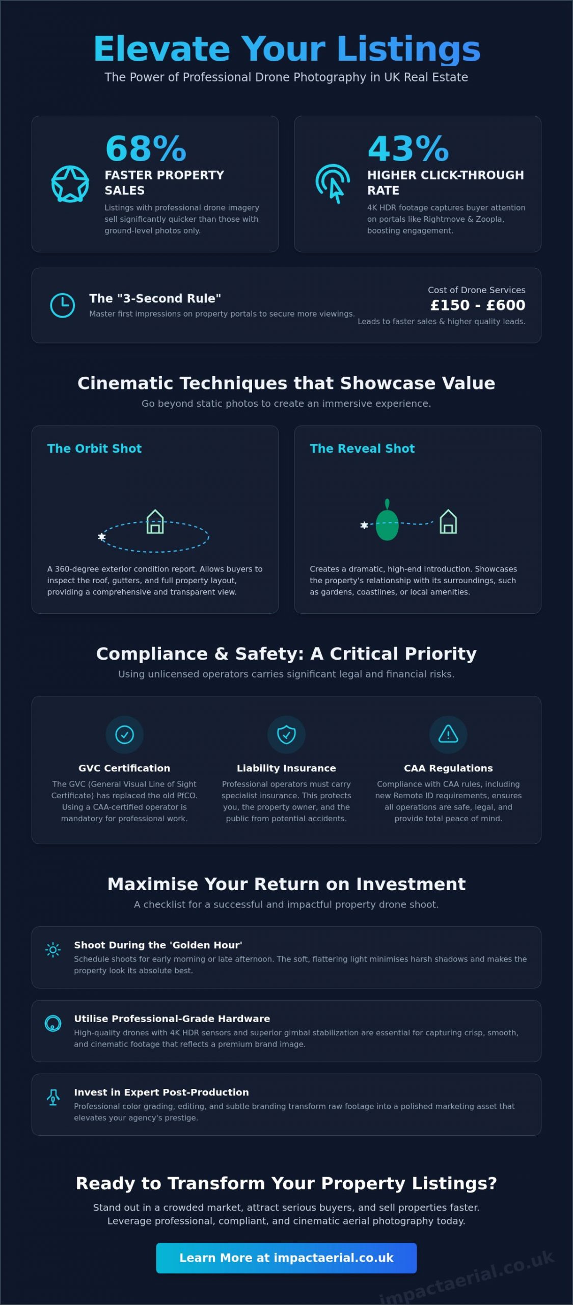
The cost-to-speed ratio for aerial services is remarkably efficient. While professional drone packages in the UK typically range from £150 to £600, the impact on liquidity is profound. For agencies investing in high-quality Drone Services, properties featuring aerial cinematography sell up to 68% faster than those without. This isn’t just about “pretty pictures”; it’s about data-driven filtering. Immersive video tours allow prospective buyers to conduct a comprehensive visual inspection before they ever book a viewing. This process reduces “wasted” appointments by ensuring that only serious, informed leads progress to the physical viewing stage. Contextual Value is the measurable increase in a property’s perceived worth derived from clearly illustrating its physical relationship with its environment, boundaries, and local infrastructure.
It’s understandable to feel anxious about evolving drone laws or potential privacy complaints, but professional aerial cinematography has transitioned from a luxury to a tactical necessity. This guide demonstrates how to leverage 4K HDR footage to achieve a 43% higher click-through rate while ensuring your marketing remains fully CAA compliant. We’ll explore how to navigate GVC certification, insurance mandates, and the latest Remote ID requirements to provide total peace of mind. You’ll learn how to transform your agency’s brand image, increase offer-to-viewing ratios, and secure significantly faster completion times.
Key Takeaways
- Master the “3-second rule” on major property portals to significantly increase engagement and secure a 43% higher click-through rate for your listings.
- Learn how cinematic ‘Orbit’ and ‘Reveal’ shots provide a comprehensive exterior condition report and showcase the property’s relationship with the surrounding landscape.
- Understand the critical legal shift from PfCO to GVC and why using a CAA-certified operator is mandatory for professional liability and safety compliance.
- Maximise your return on investment in drone photography for property listings uk by strategically timing shoots for the ‘Golden Hour’ to achieve the most flattering light.
- Discover the technical benefits of professional-grade drone hardware and expert post-production editing in creating a high-prestige brand image for your agency.
Table of Contents
- The Science of First Impressions: Why Drone Footage Sells UK Property 68% Faster
- Beyond the Bird's Eye View: Cinematic Techniques to Showcase Property Value
- Compliance, Safety, and Insurance: The Hidden Risks of Unlicensed Drone Operators
- Maximising Your ROI: A Checklist for a Successful Property Drone Shoot
- Elevating Your Listings with Impact Aerial’s Professional Services
The Science of First Impressions: Why Drone Footage Sells UK Property 68% Faster
Professional property marketing has moved beyond simple aesthetics. In the 2026 market, drone photography for property listings uk functions as a sophisticated hybrid of cinematic storytelling and architectural documentation. It’s no longer enough to show what a house looks like; you must demonstrate how it sits within its environment. The history of aerial photography illustrates a clear trajectory from specialized surveyance to an essential commercial tool. Today, this technology provides the technical precision required to justify premium valuations while delivering the visual impact needed to stop the scroll.
On major portals like Rightmove and Zoopla, the “3-second rule” is absolute. Potential buyers make a subconscious decision to click or skip within moments of seeing a thumbnail. Static, ground-level images often struggle to compete in a saturated feed. By contrast, high-quality 4K HDR footage triggers an immediate emotional response. It captures the “lifestyle” element of a listing by offering perspectives that feel immersive rather than observational. This shift from static imagery to cinematic video has become a standard buyer expectation, particularly for high-value UK estates.
To better understand how these technical elements translate into effective marketing, watch this helpful video guide:
The ROI of Aerial Cinematography in Real Estate
The cost-to-speed ratio for aerial services is remarkably efficient. While professional drone packages in the UK typically range from £150 to £600, the impact on liquidity is profound. Properties featuring aerial cinematography sell up to 68% faster than those without. This isn’t just about “pretty pictures”; it’s about data-driven filtering. Immersive video tours allow prospective buyers to conduct a comprehensive visual inspection before they ever book a viewing. This process reduces “wasted” appointments by ensuring that only serious, informed leads progress to the physical viewing stage. Contextual Value is the measurable increase in a property’s perceived worth derived from clearly illustrating its physical relationship with its environment, boundaries, and local infrastructure.
Capturing the ‘Dream’ Beyond the Front Door
Aerial perspectives allow agents to highlight proximity to local amenities, schools, and transport links with total clarity. A single elevated shot can confirm a property’s distance from a desired park or a commuter station, providing the geographical proof buyers crave. This is a core component of professional drone photography. It accurately showcases the true scale of gardens, outbuildings, and land boundaries that ground-based wide-angle lenses often distort. For large estates or rural properties, this bird’s eye view is the only way to provide an honest and prestigious representation of the land on offer.
Beyond the Bird’s Eye View: Cinematic Techniques to Showcase Property Value
Effective drone photography for property listings uk requires more than just launching a aircraft and capturing a static image from 40 metres. To truly differentiate a listing in the 2026 market, we utilise specific cinematic flight patterns that serve as both marketing assets and technical records. These maneuvers provide a level of detail that ground photography simply cannot replicate, offering a comprehensive view of the asset’s condition and its relationship with the surrounding environment.
The Orbit shot is a foundational technique where the drone circles the property at a consistent radius. This provides a 360-degree exterior condition report, allowing prospective buyers to inspect the roof, chimney stacks, and elevations from every angle. For properties in the West Midlands or rural UK, the Reveal shot is particularly effective. We start at ground level, often focused on the front entrance, before ascending to showcase the property’s position within the wider landscape. To provide an immersive experience, Fly-Through sequences using FPV (First Person View) drones create seamless transitions from interior hallways out into the gardens. Finally, Top-down ‘Map’ shots provide a zenith perspective, offering an accurate architectural representation of the entire plot and its boundaries.
Commercial Property Surveys vs. Residential Marketing
While residential sales focus on emotion, commercial marketing demands precision. For developers and investors, we deploy a specialised survey drone to gather technical data alongside aesthetic footage. Using photogrammetry, we create detailed 3D models that potential investors can explore remotely from anywhere in the world. This integration of data-gathering with high-quality filming ensures the shoot serves a dual purpose: attracting interest while providing the technical due diligence required for commercial transactions. To ensure these maneuvers are performed safely, all operations must strictly adhere to UK drone regulations regarding flight in congested areas.
Post-Production: Making the Footage ‘Pop’ in 2026
Post-production is where raw data becomes a persuasive marketing tool. We use professional colour grading and High Dynamic Range (HDR) processing to ensure the footage looks exceptional on modern 4K displays. In 2026, adding subtle text overlays is a standard way to highlight key selling points, such as ‘Underfloor Heating’ or ’10 mins to Station’, directly onto the aerial view. We also tailor the pacing and music of our edits specifically for social media platforms like TikTok and Instagram Reels, where fast-paced, high-impact visuals drive the most engagement. If you’re unsure which cinematic technique best suits your specific plot, you can view our portfolio of professional services for inspiration.
Compliance, Safety, and Insurance: The Hidden Risks of Unlicensed Drone Operators
Engaging a “friend with a drone” or an uncertified hobbyist for drone photography for property listings uk represents a significant legal and financial risk for estate agencies. While the initial cost may seem lower, the potential liability in the event of an accident is immense. If an unlicensed pilot operates commercially and causes property damage or personal injury, the estate agent who commissioned the work can be held legally responsible. Professionalism in 2026 requires more than just a high-quality camera; it demands a deep understanding of the regulatory framework that governs UK airspace.
The regulatory landscape has evolved significantly. The older PfCO (Permission for Commercial Operations) has been fully replaced by the GVC (General Visual Line of Sight Certificate) as the primary standard for professional operators. This qualification ensures the pilot has undergone rigorous training and examination by a CAA-approved entity. Beyond basic flight skills, a GVC holder understands complex commercial real estate drone applications, including how to safely navigate congested residential environments. For added peace of mind, we maintain £5 million in commercial liability insurance, which is the professional standard for any property shoot in the UK. This coverage is compliant with regulation EC 785/2004, protecting all parties involved from the financial fallout of unforeseen incidents.
The Impact Aerial Safety Protocol
Operating in urban environments like Birmingham and across the West Midlands requires meticulous planning. Our safety protocol begins with a comprehensive pre-flight risk assessment for every location. We identify potential hazards such as overhead power lines, tall trees, or high-traffic pedestrian areas before the drone ever leaves the ground. Managing Flight Restricted Zones (FRZs) is another critical aspect of our service. We handle all necessary coordinate clearances when working near airports or sensitive government sites. You can rest assured that all our operations strictly adhere to the latest 2026 CAA regulations regarding the protection of uninvolved persons and property.
Why CAA GVC Certification Protects Your Brand
Using a certified professional isn’t just about avoiding fines; it’s about brand protection. High-net-worth clients and sensitive neighbouring residents are increasingly aware of privacy laws and the Data Protection Act. An unlicensed operator filming over private gardens can quickly lead to formal complaints or legal action against your agency. By hiring a GVC-certified pilot, you demonstrate a commitment to legality and respect for the community. This meticulous approach provides a “peace of mind” factor that enhances your reputation as a trusted specialist. For a more detailed breakdown of these requirements, refer to our UK drone license guide which explains the current rules in depth.
Maximising Your ROI: A Checklist for a Successful Property Drone Shoot
Achieving a high return on investment with drone photography for property listings uk depends on the synergy between technical flight skill and meticulous site preparation. A successful shoot isn’t a matter of chance; it’s the result of a structured workflow that accounts for environmental variables and aesthetic precision. In the 2026 market, where high-resolution sensors and High Dynamic Range (HDR) processing are standard, every detail on the ground is magnified. Proper preparation ensures that the final assets justify a premium valuation and accelerate the sales process.
Timing is the most critical factor for cinematic quality. We recommend scheduling shoots during the ‘Golden Hour’, the period shortly after sunrise or before sunset. The low angle of the sun provides soft, directional light that creates depth through gentle shadowing, avoiding the harsh, flat highlights of midday sun. Weather conditions also dictate the technical feasibility of the operation. While our DJI Enterprise fleet offers superior stability, we strictly adhere to safety limits regarding wind speeds, typically staying below 20mph, and avoid precipitation to prevent water droplets from compromising the lens clarity or damaging sensitive electronics.
Proactive communication with neighbours is a vital step in our safety protocol. Informing residents of a planned shoot prevents privacy complaints and ensures a smooth operation. This transparency builds trust and maintains the prestige of your agency. Before our pilot arrives, a ‘clean sweep’ of the grounds is essential to remove any visual distractions that could detract from the property’s appeal. To ensure your listing is ready for capture, you can book a professional site consultation with our team.
The Pre-Shoot Property Prep List
- Window Clarity: Ensure all windows are professionally cleaned. High-resolution drone sensors easily pick up reflections, streaks, and dirt, which can be difficult to correct in post-production.
- Landscaping: Mow lawns and trim hedges 24 hours before the shoot. From an aerial perspective, a manicured garden creates a strong sense of order and care.
- De-cluttering: Hide all ‘eye-sores’ including wheelie bins, vehicles, garden hoses, and children’s trampolines. These items break the cinematic flow and anchor the property in the mundane rather than the aspirational.
Working with Your Pilot on the Day
Effective collaboration on-site is key to capturing the property’s unique selling points (USPs). We begin each session with a briefing to identify the ‘best side’ of the building and any specific features, such as solar arrays or custom outbuildings, that require detail shots. During the operation, we maintain ‘sterile zones’ to ensure the safety of all persons on site. This allows the pilot to focus entirely on the flight path and the composition of the 4K footage. Before concluding the shoot, we review the raw data on-site to confirm that every critical angle for the listing has been captured to our leading quality standards.
Elevating Your Listings with Impact Aerial’s Professional Services
Impact Aerial provides a comprehensive end-to-end service designed to transform standard listings into high-performance marketing assets. We utilize the latest 4K HDR DJI Enterprise commercial drones. These systems offer superior stability and image quality compared to consumer-grade hardware, ensuring that every frame is sharp, vibrant, and professional. Our process begins with an in-depth airspace consultation to ensure every flight is legal and safe. We then move through precise data-gathering to cinematic post-production editing. This integrated approach ensures that drone photography for property listings uk becomes a seamless addition to your marketing workflow.
Our expertise extends beyond simple photography. We offer a range of specialized drone services that can be tailored to meet the specific requirements of any asset. Based in Birmingham, we provide expert coverage across the West Midlands and the wider UK. Every client benefits from our meticulous attention to detail and unwavering commitment to regulatory compliance. We don’t just fly drones; we provide a technical consultancy that adds tangible value to your business.
Bespoke Packages for Every Property Type
We recognize that a single-family home requires a different tactical approach than a multi-unit commercial development. Our Residential ‘Starter’ packs are specifically engineered for high-end home listings. These focus on highlighting the architectural beauty and garden scale that attract discerning buyers. For commercial property developers, our ‘Master’ packs provide the high-volume data and sweeping perspectives needed for new-build estates and large-scale sites. We also offer seamless virtual tour integration. This allows potential buyers to transition from an aerial overview to a fully immersive 3D experience, providing an interactive viewing that is becoming the 2026 standard for high-prestige listings.
Book Your Aerial Property Shoot Today
The tactical advantage of professional aerial cinematography is clear. In a market where listings with drone footage sell up to 68% faster, failing to utilize this technology is a significant commercial disadvantage. Impact Aerial offers more than just breath-taking end results; we provide the reassurance of full CAA GVC certification and £5 million in commercial liability insurance. This ensures your agency remains compliant and your clients’ assets are protected during every operation.
For added peace of mind, our team handles every aspect of the operation, from risk assessment to final delivery. Whether you’re an estate agent in the West Midlands or a developer looking for national coverage, we’re ready to elevate your brand. Contact our Birmingham-based team today for a professional consultation. Discover how we can accelerate your property sales and enhance your agency’s reputation in this niche but increasingly diverse market.
Future-Proof Your Real Estate Marketing Strategy
The transition toward immersive, data-driven property listings is now complete. By utilizing advanced cinematic techniques and ensuring total regulatory compliance, you can accelerate sales cycles and justify higher valuations with total confidence. High-quality drone photography for property listings uk provides the environmental context and visual prestige that today’s buyers expect from a leading agency. We’ve explored how the 68% increase in sales speed is driven by technical precision and the vital 3-second rule on digital portals.
For added peace of mind, our team of CAA GVC Certified pilots operates a 4K HDR DJI Enterprise fleet to deliver breathtaking results with surgical accuracy. We provide £5m in commercial liability insurance for every project, ensuring your agency and your clients are fully protected. As Birmingham and West Midlands specialists, we understand the local landscape and the specific airspace requirements of the region intimately.
It’s time to elevate your brand and secure a competitive edge in a crowded market. Book your professional property drone shoot with Impact Aerial today to start transforming your listings. We look forward to helping you showcase your properties from a perspective that truly sells.
Frequently Asked Questions
Do drone photos really help sell a house faster in the UK?
Properties featuring professional aerial imagery sell up to 68% faster than those relying on traditional ground-level photography. This efficiency is largely due to the increased engagement on portals like Rightmove, where listings with drone footage see a 43% higher click-through rate. By providing immediate environmental context, you filter for serious buyers who understand the property’s scale before booking a physical viewing.
How much does it cost to get drone footage of a property in the UK?
Professional fees for drone photography for property listings uk typically range from £150 to £600 per project. Prices vary based on the complexity of the shoot and regional market rates. For example, the average cost in London and southern regions is approximately £550, while northern areas often average around £350. These figures generally include high-resolution 4K capture and professional post-production editing.
Do I need permission from neighbours to use a drone for property photos?
Formal permission isn’t legally required if the pilot operates within CAA safety guidelines, but proactive communication is essential for a smooth shoot. Professional operators must adhere to the Data Protection Act and privacy laws. We ensure that our flight paths avoid capturing identifiable individuals or the private interiors of neighbouring homes, providing peace of mind for both the vendor and the community.
Can drones fly in residential areas for real estate photography under 2026 rules?
Drones can operate in residential areas provided the pilot holds the correct CAA certification and the aircraft has a valid UK class mark. Under 2026 regulations, any drone with a camera requires an Operator ID and a Flyer ID. For drone photography for property listings uk in congested areas, we use GVC-certified pilots who are qualified to fly closer to uninvolved persons than standard hobbyists.
What happens if the weather is bad on the day of the drone shoot?
We reschedule shoots at no extra cost if weather conditions compromise safety or image quality. Our pilots monitor forecasts for wind speeds exceeding 20mph or any form of precipitation, which can damage sensitive DJI Enterprise electronics. We coordinate closely with you to find the next available window with the ‘Golden Hour’ lighting required for premium property cinematography.
Is a special licence required for commercial drone property filming?
Commercial operators must hold a valid qualification from the Civil Aviation Authority, such as a GVC or A2 CofC. It’s also a legal requirement to carry specialist commercial insurance compliant with regulation EC 785/2004. We maintain £5 million in public liability insurance, ensuring that estate agents and homeowners are fully protected against any unforeseen financial or legal liabilities during the shoot.
How long does a typical property drone shoot take to complete?
Most residential property shoots take between 60 and 90 minutes to complete on-site. This timeframe allows for a comprehensive pre-flight risk assessment, the capture of multiple cinematic angles, and a review of the raw footage. Larger estates or commercial sites requiring 3D modeling and photogrammetry may require additional time depending on the specific data-gathering requirements of the project.
Can drone footage be used for commercial property surveys as well?
Drone technology is an excellent tool for conducting detailed exterior condition reports and architectural surveys. We use specialized hardware to capture high-resolution imagery of roofs, chimneys, and land boundaries that are otherwise difficult to access. This allows commercial developers to utilize a single flight for both technical due diligence and creating high-impact marketing assets for potential investors.
 2 Norton Drive, Wythall, Birmingham, B47 6HH Company registration number: 11138586. VAT Number: 366 9068 55


