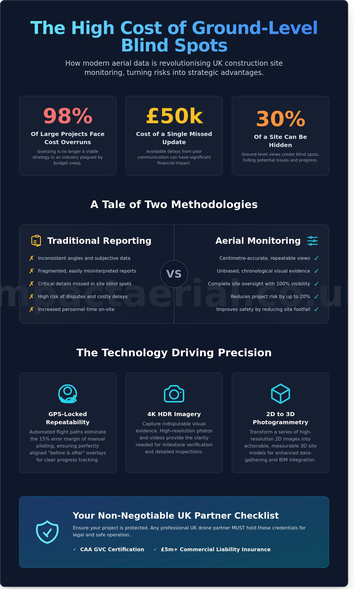
Could a single missing visual update cost your project £50,000 in avoidable delays? For UK developers managing complex sites in 2026, the gap between ground-level reporting and reality is where budgets often disappear. You already know that relying on manual inspections or inconsistent aerial progress photos for developers leads to miscommunication with remote stakeholders. It’s a frustrating bottleneck that stalls decision-making and leaves your firm vulnerable to expensive project disputes. In an industry where 98% of large-scale projects face cost overruns, guessing is no longer a viable strategy.
This guide demonstrates how professional drone data transforms site monitoring from a reactive chore into a strategic asset. By using CAA GVC certified pilots and 4K HDR drone technology, you’ll gain high-resolution visual evidence that reduces project risk by up to 20% through better oversight. We’ll examine how repeatable visual data improves stakeholder transparency and provides the added peace of mind required to keep your 2026 developments on schedule and within budget. Discover how to leverage technical precision for better results.
Key Takeaways
- Understand why traditional site monitoring is outdated and how aerial perspectives capture the full scale of complex 2026 development projects.
- Discover how to utilise GPS-locked flight paths and 4K HDR imagery to produce consistent aerial progress photos for developers that integrate with BIM software.
- Learn how to significantly reduce project risk and physical inspection time while improving safety by keeping personnel away from hazardous site areas.
- Explore the technical process of using photogrammetry to transform high-resolution 2D imagery into actionable 3D site models for enhanced data-gathering.
- Identify the non-negotiable compliance requirements for UK drone partners, including mandatory CAA GVC certification and £5m commercial liability insurance for added peace of mind.
The Evolution of Construction Site Monitoring: Why Developers are Looking Up
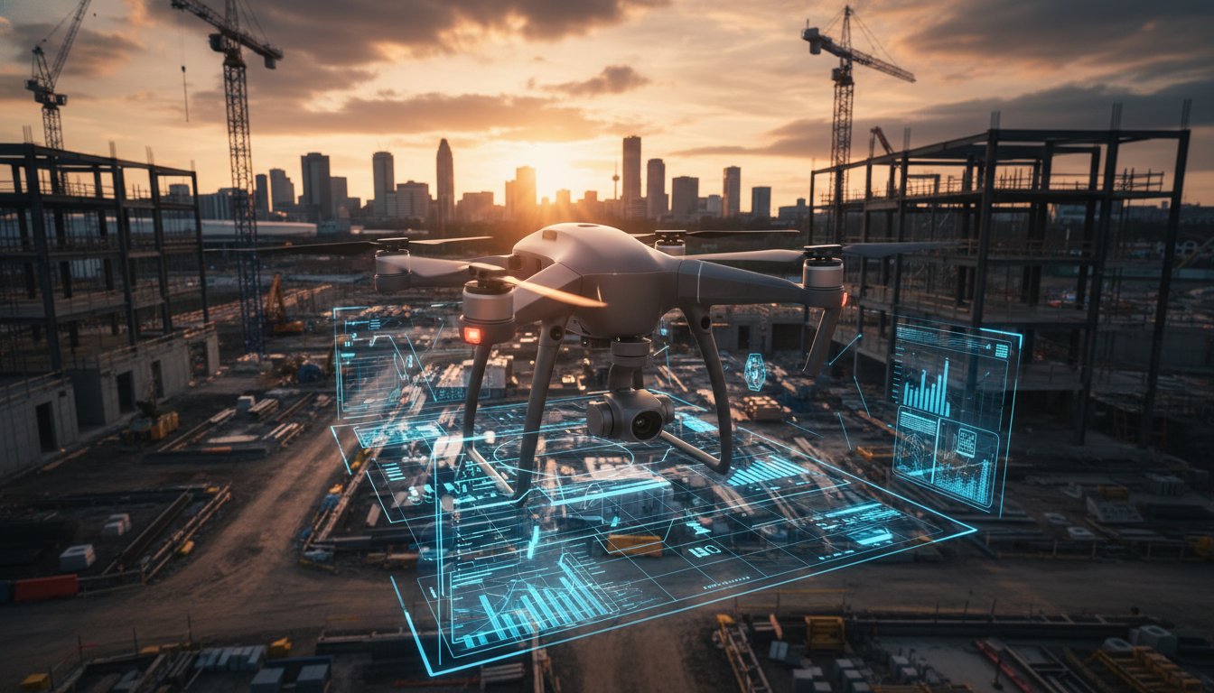
Construction monitoring has moved beyond the clerk of works walking a site with a clipboard and a handheld camera. Today, aerial progress photos for developers represent a systematic, data-driven method of documenting every stage of a build from a precise, repeatable vantage point. By deploying a professional unmanned aerial vehicle (UAV), project managers gain a high-altitude perspective that ground-based teams simply can’t replicate. This isn’t about capturing a single “hero shot” for a marketing brochure. It’s a strategic shift toward weekly or monthly captures that provide an unbiased, chronological record of a project’s lifecycle.
The current industry standard has evolved from occasional photography to rigorous visual data gathering. In 2024, UK construction firms reported a 22% increase in drone adoption for site oversight. By 2026, high-resolution aerial monitoring will be a standard requirement for any project valued over £5 million. This “unbiased eye” ensures that remote stakeholders and off-site directors have a clear, unfiltered view of the site’s evolution without needing to travel to the location.
To see how these reports streamline the construction process, watch this helpful video:
Limitations of Traditional Site Reporting
Ground-level inspections often miss critical details. Perimeter fences and complex scaffolding create visual blind spots that can hide up to 30% of a site’s active footprint. Traditional photography often suffers from inconsistent angles and varied lighting when handled by non-specialists. Capturing progress on a £12 million internal courtyard or a complex roof-level installation requires a vertical vantage point that no ladder or telescopic pole can reach. Without standardised aerial views, reporting becomes subjective and fragmented.
Meeting the Demands of 2026 Stakeholders
Modern investors demand absolute transparency. By 2026, real-time visual updates will be a non-negotiable part of institutional project reporting. High-resolution aerial progress photos for developers allow for the immediate validation of contractor milestones against the agreed programme. This verifiable evidence provides peace of mind for remote stakeholders, ensuring that payment schedules align perfectly with physical reality. It removes the guesswork from site meetings and provides a definitive record that protects all parties involved in the development.
Technical Precision: How Drone Progress Photography Works
Modern site monitoring has evolved significantly from the manual history of aerial photography programs. Today, we utilise 24-satellite GPS constellations to lock flight paths with centimetre-level accuracy. This technical rigour ensures that aerial progress photos for developers provide a scientific record of construction rather than just a collection of pretty pictures. By removing human variance, we create a reliable data stream that project managers use to verify sub-contractor milestones and material deliveries.
GPS-Locked Repeatability
Automated flight plans eliminate the 15% margin of error typical of manual piloting. By using waypoint navigation, our drones return to the exact spatial coordinates; latitude, longitude, and altitude; every 30 days. This precision allows for perfectly aligned “before and after” overlays. It’s the standard required to produce seamless time-lapse transitions that stakeholders use for high-stakes board reports. Reducing human error in flight path execution means every shutter click happens at the exact same angle, month after month.
High-Resolution Deliverables and Post-Production
We deploy professional-grade drones, equipped with advanced sensor technology, to capture 45-megapixel stills and 4K HDR imagery. This high dynamic range is vital in complex urban environments where shadows from adjacent skyscrapers can obscure ground-level details. Raw footage isn’t enough for professional presentations. Our post-production workflow includes:
- Colour Grading: We ensure visual consistency across a 24-month project timeline, regardless of seasonal light changes.
- Detail Enhancement: 4K resolution allows stakeholders to zoom into specific site sections, such as rebar spacing or drainage installation, without losing clarity.
- Secure Cloud Delivery: We provide 128-bit encrypted links for large-scale files, ensuring your data remains private and accessible to the whole team.
Consistency requires more than just hardware; it demands strict scheduling. We aim for “solar noon” to minimise long shadows that can hide foundation work or trenching. Capturing data at 11:00 on a specific Tuesday each month provides a controlled dataset for your records. If you require this level of consistent site oversight, the technical setup is where the ROI begins. Our CAA GVC certified pilots manage the complex airspace permissions, allowing you to focus on the build while we handle the data-rich imagery.
The ROI of Aerial Progress Photos vs. Traditional Site Inspections
Traditional site inspections often require multiple personnel to spend hours, or even days, navigating active construction zones. This manual approach is not just slow; it’s expensive. By deploying aerial progress photos for developers, project managers can capture a comprehensive site overview in less than thirty minutes. This speed doesn’t sacrifice quality. Our CAA GVC Certified pilots use 4K HDR equipment to provide a level of detail that ground-level inspections simply can’t match. This high-resolution data allows for remote site monitoring, which significantly reduces the need for expensive, time-consuming travel for stakeholders based in different regions of the UK.
While the applications of aerial photography have historically focused on cartography and planning, modern drone data provides the granular detail needed for today’s high-stakes development projects. Catching a structural misalignment or a drainage error during the first week of a build can save upwards of £20,000 in rework costs. Drones identify these discrepancies early by comparing real-time imagery against original BIM models with millimetre precision.
Cost Savings and Efficiency Gains
Manual inspections for a five-acre site typically involve a two-person team and a full day of labour, costing approximately £800 to £1,200 per visit. In contrast, a professional drone service can complete the same data-gathering exercise for a fraction of that cost while providing more versatile outputs. Adopting drone technology typically results in a 60% to 80% reduction in the time required to complete a comprehensive site survey. Beyond direct labour costs, developers also see a reduction in their carbon footprint by eliminating dozens of site commutes each month. This aligns with modern ESG (Environmental, Social, and Governance) targets now required by many UK local authorities.
Risk Mitigation and Insurance Benefits
Safety is a non-negotiable priority on any UK site. According to the Health and Safety Executive (HSE) 2023 report, falls from height remain the leading cause of workplace fatalities in construction. Drones keep your staff on the ground, away from fragile roofs and hazardous scaffolding. This proactive approach to safety can lead to more favourable terms with providers of commercial liability insurance. Aerial progress photos for developers also act as an indisputable digital ledger. If a dispute arises regarding a contractor’s timeline or the quality of materials used, you have a time-stamped, high-definition visual record to resolve the issue quickly and avoid costly legal fees.
Effective risk management also extends beyond the site itself to encompass comprehensive transport planning. For instance, specialist firms like ML Traffic Engineers Australia provide crucial traffic impact assessments that can prevent costly logistical bottlenecks and planning disputes long before construction begins.
- Dispute Resolution: Clear evidence of work completed at specific dates.
- Compliance: Visual proof of health and safety adherence for HSE audits.
- Marketing: High-quality visuals that secure off-plan sales and investor confidence months before completion.
Integrating Aerial Data into Your Development Workflow and BIM
Modern construction demands more than just visual updates. Integrating aerial progress photos for developers into a Building Information Modelling (BIM) workflow transforms raw imagery into actionable intelligence. Since the UK government mandated BIM Level 2 for all centrally procured projects, the industry has seen a 20% increase in the adoption of drone-derived data to maintain compliance and accuracy. It’s no longer about simple snapshots. It’s about creating a living record of the site that syncs with your digital architecture.
From Photos to 3D Models
Photogrammetry is the engine behind this digital transformation. By capturing hundreds of high-resolution images with a 70% overlap, our CAA GVC certified pilots generate dense point clouds. These datasets provide 1-2cm relative accuracy for site volume measurements. This precision is vital when calculating muck-away costs or measuring stockpiles of expensive materials like primary aggregate. Developers often save upwards of £1,500 per survey by replacing manual ground measurements with drone-led data gathering. You can export these models directly into platforms like Autodesk Revit or Navisworks. This allows your BIM manager to spot clashes between the “as-built” reality and the “as-designed” plans before they become costly site rectifications.
Streamlining Stakeholder Communication
Clear communication is the backbone of any successful £10m+ development. Aerial data bridges the gap between the site office and the boardroom. Instead of static reports, you can provide off-site investors with immersive 360-degree virtual tours. This gives them a “boots on the ground” perspective without the health and safety risks of a live site visit. Using aerial overlays, project managers can demonstrate precisely how the build aligns with the original programme of works. This level of transparency has been shown to reduce internal reporting time by 25% for UK firms. Automated weekly reports ensure that board members receive consistent, high-quality updates every Monday morning, keeping the project on track and within budget.
For added peace of mind and technical precision on your next site, choose a professional partner who understands the intricacies of CAA regulations and high-end data delivery. Partner with Impact Aerial to integrate professional drone data into your development workflow.
Choosing a Compliant Partner for Aerial Progress Photos in the UK
Selecting a drone operator isn’t just about capturing the right angles. It’s about mitigating risk on high-value construction sites. By January 2026, the transition from the old PfCO to the General Visual Line of Sight Certificate (GVC) will be the mandatory standard for complex commercial operations. Developers must ensure their chosen partner holds this CAA-approved qualification to guarantee they’re operating within the latest legal frameworks. This certification proves a pilot’s ability to handle advanced flight manoeuvres and rigorous safety protocols in congested areas.
Navigating UK Drone Regulations
The shift from PfCO to GVC ensures that pilots possess the technical skills required for high-risk urban environments. For every project involving aerial progress photos for developers, we produce site-specific Risk Assessments and Method Statements (RAMS). These documents aren’t mere formalities; they’re essential safety blueprints that protect your site’s stakeholders and personnel. We also strictly adhere to the Data Protection Act 2018. This ensures that any identifiable data captured during urban flights remains fully compliant with UK privacy laws, protecting you from potential GDPR liabilities.
Standard public liability insurance often falls short for large-scale construction environments. We maintain £5 million in commercial liability insurance as an industry-standard baseline. This provides the necessary peace of mind for developers managing multi-million pound assets. Our technical edge comes from using DJI Enterprise hardware equipped with 4K HDR cameras. These systems use mechanical shutters to eliminate rolling shutter distortion, providing the crisp, high-contrast imagery needed for precise site monitoring and reporting.
The Impact Aerial Advantage
Choosing a specialist based in Birmingham or the West Midlands allows for rapid deployment when specific weather windows open. We understand the local geography and the specific requirements of the region’s planning authorities. Our service includes customisable post-production to ensure your aerial progress photos for developers align perfectly with your corporate branding and visual identity. This meticulous attention to detail helps you present a professional, authoritative image to investors and stakeholders alike. You can organise a consultation for your next project to see how our safety-conscious approach delivers tangible ROI for your development programme.
Optimise Your Development Oversight for 2026
Adopting advanced drone technology isn’t just about capturing visuals; it’s about securing a 20% improvement in project transparency across your entire supply chain. Integrating high-resolution data into your BIM software allows for real-time adjustments that prevent costly delays before they occur. For added peace of mind, professional aerial progress photos for developers ensure your site records meet the rigorous standards required for 2026 planning and compliance audits.
Impact Aerial provides the technical expertise your project demands. Our team operates the latest 4K HDR DJI Enterprise fleet to deliver meticulous detail on every flight. Every operation is handled by CAA GVC Certified Pilots and backed by £5m commercial liability insurance, ensuring your development stays protected and compliant. We’re ready to help you transform how you track, manage, and showcase your build’s evolution. Your project deserves the clarity and precision that only an industry-leading partner can provide.
Book your professional aerial progress monitoring with Impact Aerial and take control of your site’s data today.
Frequently Asked Questions
How often should a developer book aerial progress photos?
Monthly visits are the industry standard for 85% of UK construction projects to ensure consistent documentation for stakeholder reports. Large-scale developments with a valuation exceeding £10 million often require fortnightly captures to track rapid structural changes and maintain precise project timelines. This regular schedule allows you to identify potential delays early and provides a visual archive that helps resolve 95% of future contractor disputes.
Is it legal to fly drones over active construction sites in UK city centres?
Yes, it’s legal provided the operator holds the correct Civil Aviation Authority (CAA) GVC certification and adheres to the Specific category regulations. For congested city centres like London or Birmingham, we operate under a PDRA01 authorisation or a specific Operating Safety Case. These legal frameworks allow us to capture high-quality aerial progress photos for developers in complex urban environments while maintaining strict safety distances from uninvolved persons.
What is the difference between progress photography and a full drone survey?
Progress photography focuses on visual storytelling and marketing, whereas a drone survey provides measurable topographic data. A survey uses photogrammetry to create 3D point clouds and orthomosaic maps with a high accuracy of 1cm to 3cm. In contrast, aerial progress photos for developers use 4K HDR sensors to document site conditions and aesthetic milestones for investor updates, site meetings, and social media content.
Can aerial progress photos be integrated into BIM software?
You can integrate high-resolution aerial data into Building Information Modelling (BIM) platforms such as Autodesk Revit or Navisworks. By using 2D orthomosaics, developers overlay current site reality against 3D design models to identify 100% of structural deviations early. This integration helps project managers spot clashes between the planned design and the actual build, which can reduce costly rework expenses by up to 15%.
How much does a professional drone progress photo package cost in the UK?
Professional drone photography packages typically range from £350 to £750 per site visit in the UK. This price includes the pilot’s day rate, comprehensive CAA compliance planning, and the post-production of high-resolution images. For long-term contracts spanning 12 to 24 months, many developers secure a 10% to 20% discount by pre-booking a set number of monthly visits for the duration of the project.
What happens to the flight schedule if the British weather is poor?
We monitor Met Office forecasts 48 hours in advance and reschedule flights if wind speeds exceed 20mph or if heavy rain is predicted. Our DJI Enterprise drones carry an IP55 rating, meaning they can operate in light drizzle, but we prioritise image clarity and safety above all else. If a flight is postponed due to weather, we typically re-deploy the pilot within 24 to 48 hours to ensure your reporting schedule stays on track.
Do I need to notify neighbours or local councils before drone flights?
You don’t usually need formal permission from local councils for flights over private land, but notifying immediate neighbours is a best practice for 100% transparency. As CAA GVC certified operators, we manage the technical flight risk assessment and check for any Flight Restriction Zones or Temporary Restricted Areas. We recommend informing site staff 24 hours before our arrival to ensure everyone is aware of the scheduled aerial activity.
What insurance should a drone operator have for commercial construction sites?
A professional drone operator must have EC 785/2004 compliant commercial liability insurance with a minimum cover of £5 million. For added peace of mind, we carry £10 million in public liability insurance to meet the stringent requirements of Tier 1 contractors and major UK developers. This specialist cover protects against third-party property damage and personal injury, ensuring your project remains fully protected during every flight.
