
Professional Aerial Video Editing Services: Transforming Raw Drone Footage into High-Impact Content

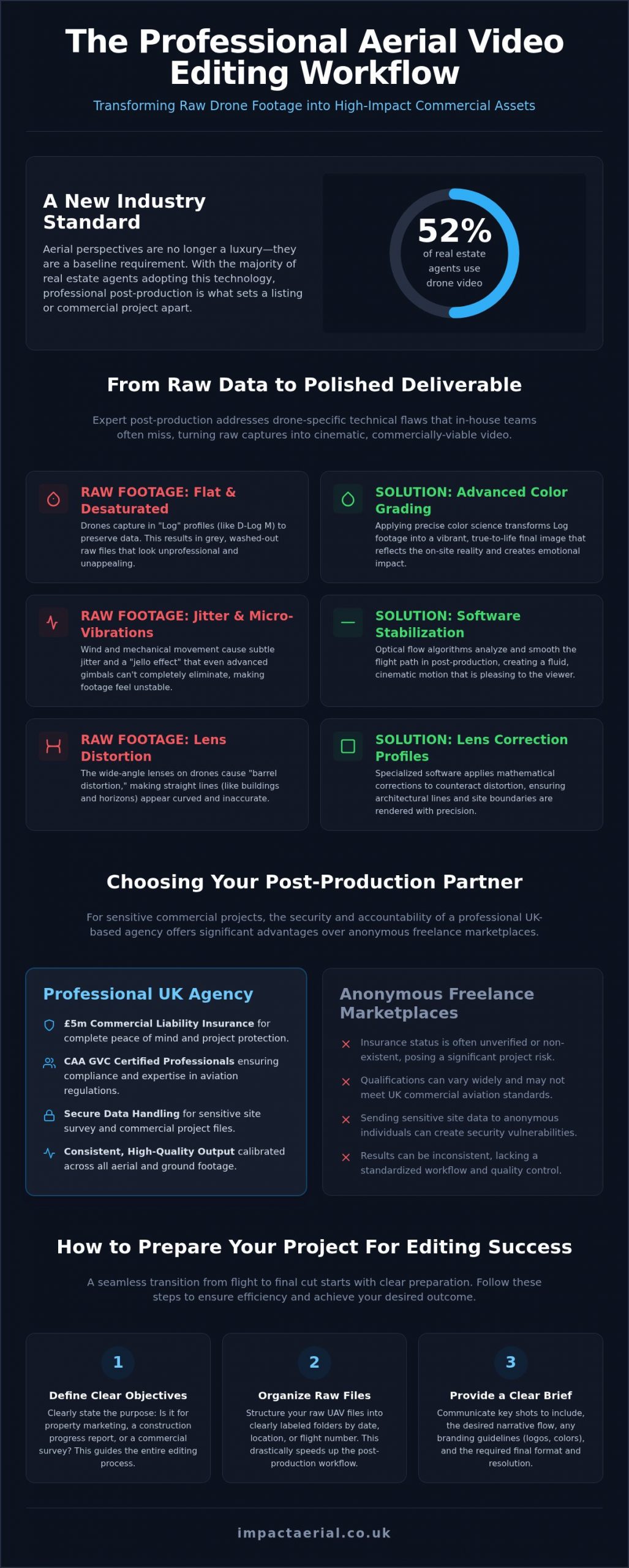
With 52% of real estate agents now using drone video as a standard marketing tool, aerial perspectives have shifted from a luxury to a baseline requirement for UK businesses. However, capturing high-bitrate 4K HDR footage is only the first step in a complex technical workflow. You likely understand the frustration of reviewing raw files only to find the horizon is slightly tilted, the colors appear flat, or the motion feels jittery due to mismatched frame rates. Managing these massive data sets in-house often proves inefficient and technically demanding for most marketing teams.

Professional aerial video editing services bridge the gap between raw data and a polished, high-impact deliverable. This guide explains how expert post-production transforms unrefined drone captures into cinematic marketing assets that drive ROI and precise commercial surveys for site monitoring. We will examine the essential role of specialized software, the importance of working with CAA GVC certified professionals who carry £5m commercial liability insurance, and the methods used to seamlessly integrate ground-based footage with aerial views for a cohesive, professional result in 2026.

Key Takeaways

  • Understand why professional aerial video editing services are essential for managing high-bitrate 4K HDR files and transforming raw data into high-impact content.
  • Learn how expert post-production solves common drone-specific issues like micro-vibration and inconsistent colour grading between aerial and ground-based sensors.
  • Compare the security advantages of using a UK-based agency with £5m commercial liability insurance versus anonymous freelance marketplaces for sensitive site data.
  • Master the preparation process by defining clear objectives and organising raw UAV files to ensure a seamless transition from flight to final cut.

What Are Professional Aerial Video Editing Services?

Rooted in a discipline that stretches back further than most people realise, the history of aerial videography shows that capturing the world from above has always demanded a distinct technical approach. Today, that principle is no different. Professional aerial video editing services are a specialised post-production discipline focused on transforming raw UAV captures into structured, commercially purposeful narratives. It’s a process that demands far more than a competent editor and a fast computer; it requires a precise understanding of drone-specific file formats, flight-induced artefacts, and the visual language required to communicate value to a target audience.

The core challenge is the raw material itself. DJI Enterprise drones capture footage in log colour profiles, such as D-Log M, to preserve the maximum possible dynamic range across bright skies and shadowed ground detail simultaneously. These flat, desaturated files are deliberately unfinished. Without expert colour science applied in post-production, the footage looks washed out and unprofessional. A skilled editor interprets that raw data and grades it into a final image that reflects what the human eye actually perceives on site.

The Distinction Between Basic Cutting and Professional Post-Production

Basic cutting is a trim-and-join operation. Clips are shortened, arranged in sequence, and exported. Professional post-production is an entirely different workflow. It involves colour grading calibrated to the specific log format used, sound design that reinforces the visual pace, motion stabilisation to eliminate wind-induced jitter, and a narrative-led editorial structure that guides a viewer from opening context through to a clear commercial conclusion. For property marketing or construction site monitoring, that structure is what converts a viewer into an enquiry.

The Importance of Specialised Tools for Drone Footage

Handling high-bitrate 4K HDR files demands industry-standard software. Platforms like DaVinci Resolve and Adobe Premiere Pro are built to manage the processing load these codecs require and provide the colour management pipelines necessary to work accurately within log colour spaces. Critically, specialised software also applies lens correction profiles that mathematically counteract the wide-angle barrel distortion inherent in drone camera optics, ensuring that straight building lines and site boundaries are rendered accurately in the final output.

This level of technical rigour is precisely what separates a professional service from a low-cost clip-trimming solution. For UK businesses commissioning drone content for property sales, commercial surveys, or construction monitoring, the quality of post-production directly determines the commercial value of the asset delivered.

Technical Challenges Solved by Expert Aerial Editors

Capturing raw data with a drone is only half the battle. Even with high-end DJI Enterprise hardware, environmental factors like wind resistance and light fluctuations introduce technical flaws that can undermine a project’s credibility. Professional aerial video editing services exist to rectify these specific issues, ensuring that the final deliverable meets the rigorous requirements of commercial stakeholders. By applying advanced post-production techniques, editors can salvage footage that would otherwise be unusable due to optical distortions or mechanical vibrations.

Stabilisation and Motion Smoothing

The physics of drone flight means that a UAV is constantly fighting against air resistance and turbulence. While modern 3-axis gimbals are remarkably effective, they cannot eliminate every micro-vibration. Professional editors use software-based stabilisation, often employing optical flow algorithms and point-tracking to smooth out the flight path. This process is essential for removing the “jello effect,” a common rolling shutter artifact caused by the CMOS sensor’s sequential line scanning. By correcting these timing discrepancies, the editor ensures the motion feels cinematic and fluid rather than mechanical and distracting.

Advanced Colour Grading for Commercial Impact

Most commercial drone footage is recorded in “Log” profiles to preserve the maximum amount of data in highlights and shadows. However, this leaves the raw files looking grey and desaturated. Editors must transform these profiles using precise colour science to achieve true-to-life vibrancy while maintaining brand consistency across multiple sites. Expert colour grading enhances the emotional appeal of real estate drone photography by creating a warm, inviting atmosphere that resonates with potential buyers. Adhering to professional standards in aerial imaging, these adjustments ensure that the visual output remains accurate for technical surveys while being aesthetically compelling for marketing.

Managing the dynamic range in 4K HDR files is another critical task. In high-contrast environments, such as a construction site at midday, the sky often appears “blown out” while the ground detail is lost in shadow. A skilled editor uses secondary colour correction and masking to recover these details, providing a balanced image that shows the full scope of a project. If your current raw data lacks this professional polish, our specialists at Impact Aerial can refine your footage into a high-impact commercial asset.

Finally, wide-angle lenses used on most drones naturally produce barrel distortion, making straight lines appear curved. This “fisheye” effect is particularly problematic for property and construction surveys where accuracy is paramount. Professional post-production applies mathematical lens correction profiles to straighten these lines, ensuring the structural integrity of the subject is represented correctly in every frame.
Professional Aerial Video Editing Services: Transforming Raw Drone Footage into High-Impact Content

Professional Agency vs. Freelance Marketplaces: A Comparison

Selecting a partner for aerial video editing services often involves a choice between the perceived convenience of global freelance marketplaces and the structured reliability of a dedicated UK agency. For commercial projects, particularly in property and construction, the latter provides a level of accountability that anonymous platforms cannot match. A professional agency operates under UK-based contracts; this ensures that project management is transparent and that legal protections are in place for both parties. This structure is essential for businesses that require reliable delivery timelines and clear communication throughout the post-production cycle.

Security is a primary concern when handling high-resolution data from sensitive sites. Freelance platforms often involve offshore processing, which introduces significant risks regarding data protection and secure file handling. In contrast, a professional agency implements rigorous internal protocols to protect client data. This commitment to risk mitigation is evidenced by maintaining substantial £5m commercial liability insurance. While some may assume insurance only applies to the flight phase, it remains a critical marker of a business’s stability and professional standing throughout the entire service lifecycle in 2026.

The Risks of Low-Cost Offshore Editing

Low-cost offshore solutions frequently result in hidden costs that aren’t immediately apparent. Communication barriers often lead to excessive revision cycles, as editors may lack an understanding of specific UK property and construction standards. There is also a heightened risk of copyright infringement. Professional agencies ensure all music, stock assets, and fonts are correctly licensed for commercial use. This protects your business from future legal complications that can arise from using unlicensed assets found on unregulated marketplaces.

The Value of Integrated End-to-End Services

There is a distinct advantage to using a provider that understands the nuances of the flight itself. Our aerial filming drone services benefit directly from an integrated post-production workflow. When the editors are also experts in flight data and DJI Enterprise systems, they can interpret metadata more effectively to correct the technical optical issues discussed earlier. This streamlined approach, from the flight deck to the final export, ensures consistency in quality across multiple regional projects. By keeping the workflow in-house, we maintain a high standard of cinematic output while ensuring that technical survey data remains precise and secure.

How to Prepare Your Aerial Project for Editing Success

Efficient post-production begins long before the first clip is imported into the timeline. To maximise the ROI of your aerial video editing services, you need a structured approach to project preparation. Without a clear workflow, the technical complexities of 4K and 8K drone data can lead to extended revision cycles and increased costs. Following a methodical four-step process ensures that the transition from raw footage to a high-impact deliverable is seamless and secure.

  • Step 1: Define the objective. Clearly state whether the output is a cinematic marketing promo designed for high engagement or a technical survey requiring precise data visualisation.
  • Step 2: Organise raw files. Group your data by date, location, and shot type. This structure allows editors to locate specific assets quickly, saving billable hours.
  • Step 3: Provide a comprehensive brief. Include your brand guidelines, preferred colour palettes, and licensed music references to ensure the final cut aligns with your corporate identity.
  • Step 4: Establish a feedback loop. Define who has final sign-off authority and set clear dates for draft reviews to keep the project on schedule.

Defining Your Narrative and Project Scope

Before any cutting occurs, you must identify your target audience and key messaging. A marketing video for a luxury property development requires a different editorial rhythm than a construction progress report. You should also specify your required aspect ratios early. While 16:9 remains the standard for websites and presentations, 2026 social media trends often demand 9:16 vertical versions for platforms like LinkedIn or Instagram. Setting these parameters at the start allows the editor to frame shots correctly during the stabilisation and cropping phases.

Data Management and File Transfer

Handling massive 4K and 8K datasets requires high-speed cloud transfer solutions. We recommend using professional platforms that maintain the integrity of your files without compression. This is especially critical for technical projects. While marketing videos focus on aesthetics, drone survey data requires specific handling to preserve original metadata. This metadata contains essential flight information and GPS coordinates that are vital for survey accuracy. If you’re ready to transform your raw data into a professional commercial asset, you can contact our Birmingham-based team to discuss your specific project requirements.

Partner with Impact Aerial for UK-Based Video Editing Excellence

Centrally based in Birmingham, Impact Aerial provides a robust technical infrastructure for clients across the UK and international markets. Our aerial video editing services are built on a foundation of professional reliability and meticulous attention to detail. We specialise in high-stakes sectors where precision is non-negotiable, including commercial property, large-scale construction monitoring, and PV solar farm thermal surveys. By maintaining a strict focus on safety and compliance, we ensure that every project meets the rigorous standards required by corporate stakeholders and national regulatory bodies in 2026.

Our operation is underpinned by £5m commercial liability insurance and a team of CAA GVC certified professionals. This isn’t just about flight safety; it’s a commitment to professional accountability throughout the entire post-production lifecycle. We understand that raw drone data is a significant investment. Our role is to protect that investment by applying advanced DJI Enterprise workflows that preserve the integrity of your 4K HDR footage while delivering a polished, high-impact final product that drives tangible business results.

Our Post-Production Toolkit and Expertise

The Impact Aerial team combines creative flair with technical precision to ensure every edit serves a specific commercial purpose. We don’t just cut clips; we understand the nuances of aerial cinematography, such as how to manage parallax and depth of field from a moving UAV. This specialised knowledge allows us to highlight architectural features or site progress with a level of insight that generalist editors often miss. Our client-focused communication ensures your vision is realised on time, with a structured feedback loop that guarantees the final export aligns perfectly with your project requirements.

Ready to Elevate Your Aerial Content?

Choosing a partner with an integrated workflow offers significant advantages over fragmented service models. When you work with a comprehensive drone services provider, you benefit from a seamless transition from the flight deck to the final cut. This end-to-end approach eliminates the data loss and communication gaps that often occur when handing off files to third-party freelancers. It ensures that the technical survey data remains precise and that the marketing assets remain consistent with your brand identity.

If you have raw footage that needs a professional touch or are planning a new project from scratch, our team is ready to assist. We provide bespoke quotes tailored to the complexity and scale of your specific requirements. Contact Impact Aerial today for professional drone video editing and discover how we can transform your aerial data into high-impact commercial content.

Maximise the Commercial Value of Your Aerial Data

Professional post-production is the final, critical step in converting raw UAV data into a high-impact commercial asset. As the industry evolves in 2026, the technical requirements for handling 4K HDR drone files have become increasingly demanding. Relying on expert aerial video editing services ensures that your footage is not just trimmed, but technically corrected for lens distortion, colour-graded for brand consistency, and stabilised for a cinematic finish. This process turns raw data into a narrative that resonates with stakeholders.

Choosing a UK-based partner like Impact Aerial provides the security and accountability your business needs for sensitive site data. Our operation is grounded in meticulous safety standards, featuring CAA GVC Certified Pilots and £5m commercial liability insurance. We utilise expert DJI Enterprise workflows to maintain the highest levels of precision from the flight deck to the final export. By integrating these specialised skills, you can deliver precise technical surveys or compelling marketing narratives that drive real ROI.

If you’re ready to transform your raw footage into professional content, our Birmingham-based team is here to help. Request a Quote for Professional Aerial Video Editing today and take the first step toward elevating your aerial perspective.

Frequently Asked Questions

How much do aerial video editing services cost in the UK?

Costing for professional post-production depends on the project’s complexity, the volume of raw data, and the required final deliverable. Technical surveys for construction sites often involve different processing than cinematic property promos. Most UK agencies provide bespoke quotes based on your specific brief rather than fixed rates. This ensures you only pay for the exact level of colour grading and stabilisation your project requires in 2026.

Can you edit drone footage that I recorded myself?

Yes, we can process and refine raw footage provided by clients, provided the files meet professional technical standards. To achieve a high-impact finish, the original data should ideally be recorded in a high-bitrate 4K log format. Our aerial video editing services can correct common issues like horizon tilt or wind jitter. However, the final quality depends heavily on the source material’s resolution and the sensor capabilities used during the flight.

What is the typical turnaround time for a professional drone video edit?

Turnaround times vary based on the project’s scope, but a standard marketing edit typically takes between three to five working days once all files are received. More complex technical surveys or construction progress videos requiring detailed motion graphics may take longer. We establish clear timelines during the initial consultation to ensure your vision is realised on schedule. Efficient data management and a clear brief are the best ways to expedite this process.

Do I need to provide the music for my aerial video?

You don’t need to provide music, as we handle the sourcing and licensing of audio tracks for you. Using unlicensed music leads to significant legal risks and copyright strikes on commercial platforms. We use professional libraries to select high-quality, royalty-free tracks that match the tone of your footage. If you have specific brand-approved audio, we can integrate that into the final cut provided you hold the necessary commercial usage rights.

What file formats do you need for professional drone editing?

We work with most industry-standard formats, but we prefer receiving raw, uncompressed files directly from the SD card. Formats like .MOV or .MP4 recorded in D-Log or D-Cinelike are ideal for preserving dynamic range. For technical surveys, maintaining original metadata is essential for accuracy. We recommend using high-speed cloud transfers to send large 4K or 8K datasets without the quality loss associated with standard email attachments or messaging apps.

Can you add motion graphics or callouts to my construction drone video?

Yes, we specialise in adding technical overlays such as site boundaries, point-of-interest callouts, and motion-tracked labels to construction footage. These graphics are essential for communicating project progress to stakeholders or identifying specific structural elements in commercial surveys. By combining creative flair with technical precision, we ensure these elements are integrated seamlessly into the moving image. This provides a clear and professional overview of the site’s development for your project reports.

Why is colour grading so important for drone footage?

Colour grading is vital because raw drone footage is often captured in a “flat” profile to maximise the data stored in shadows and highlights. Without grading, the video appears grey and desaturated. Professional editors use colour science to restore vibrancy and ensure brand consistency across different lighting conditions. This process enhances the emotional appeal of property videos and ensures technical surveys are clear, accurate, and professional in appearance for every commercial stakeholder.

Is it better to hire a local UK editor or an offshore service?

Hiring a local UK editor provides significant advantages in terms of accountability and security. Impact Aerial is centrally based in Birmingham and operates under UK contracts with £5m commercial liability insurance. Offshore services often lack an understanding of UK property standards and present risks regarding data protection for sensitive sites. Working with a domestic agency ensures clear communication and a shared understanding of the regulatory landscape, providing psychological comfort and tangible business benefits.

Drone Pilot for Hire Near Me: Your 2026 UK Hiring Guide

Searching for a ‘drone pilot for hire near me’ can feel like navigating a minefield of complex regulations and potential risks. With the rise of hobbyist flyers, how can you be certain the operator you choose is not just talented, but fully certified by the CAA, comprehensively insured, and capable of delivering professional results without putting your project or reputation on the line? The stakes are high, and hiring an uncertified pilot could lead to significant legal and financial consequences.

This comprehensive 2026 UK hiring guide is designed to provide you with complete peace of mind. We will demystify the entire process, from understanding what a fair quote in pounds (£) looks like to knowing precisely which questions to ask to verify a pilot’s credentials. Discover how to find, vet, and hire a fully-certified local drone professional, ensuring your project receives the breath-taking, high-quality results it deserves—safely, legally, and with total confidence.

Key Takeaways

  • Learn the critical difference between a hobbyist and a CAA GVC certified professional to ensure your project is safe, legal, and fully insured.
  • Use our essential 7-question checklist to confidently vet any operator before you hire, guaranteeing they meet all UK legal and technical requirements.
  • Understand the key factors that determine professional drone service costs, looking beyond simple flight time to project complexity and risk assessment.
  • Follow a proven framework to find a qualified drone pilot for hire near me, ensuring a smooth process from initial brief to final delivery of high-quality results.

Why You Must Hire a Professional Drone Pilot (Not a Hobbyist)

In 2026, the distinction between an amateur drone flyer and a professional operator is more critical than ever. When you search for a “drone pilot for hire near me,” you are not just looking for someone with a drone; you are seeking a qualified specialist. A professional pilot operates a sophisticated Unmanned Aerial Vehicle (UAV) as a commercial service, adhering to strict legal and safety standards. Hiring an unqualified hobbyist exposes your project to significant risks, including illegal flights, a complete lack of insurance coverage, and poor-quality data or imagery that fails to meet professional standards.

To understand the diverse commercial applications for qualified pilots, this short video provides an excellent overview:

UK Drone Regulations: The Non-Negotiables

In the UK, all commercial drone operations are governed by the Civil Aviation Authority (CAA). A professional drone pilot must hold specific qualifications to operate legally and safely. The two most important credentials to verify are:

  • General Visual Line of Sight Certificate (GVC): This is the current standard CAA qualification required for most commercial drone work in the UK. A GVC demonstrates a pilot has the required knowledge and practical skill to plan and execute drone flights safely, especially in complex or congested areas.
  • Commercial Insurance: For your added peace of mind, a professional operator must have specialist commercial drone insurance. The industry standard is a minimum of £5 million public liability coverage, protecting you, your property, and the public from any potential incidents.

The Value of Local Expertise

Hiring a local professional offers tangible benefits beyond mere convenience. A pilot with deep knowledge of your area, such as Birmingham and the West Midlands, understands the specific local airspace restrictions and terrain challenges. They will also be familiar with the varying permit requirements of different local councils, streamlining the planning process. This local expertise ensures faster deployment for your project and significantly reduces travel costs that would otherwise be added to your final invoice.

The Ultimate Checklist: 7 Questions to Ask Before You Hire

Finding the right professional is the most critical step in your project’s success. When you search for a drone pilot for hire near me, you’ll find numerous options, but not all operators offer the same level of safety, legality, and quality. This checklist provides a robust vetting framework, empowering you to make an informed and confident decision.

Use these seven questions to methodically assess any potential pilot or company. Their answers will reveal their professionalism, compliance, and suitability for your specific needs.

Credentials and Compliance

  1. Can I see your CAA Operational Authorisation and GVC certificate?
    This is the most important question. For any commercial drone work in the UK, the operator must hold a valid Operational Authorisation issued by the Civil Aviation Authority (CAA). The General Visual Line of Sight Certificate (GVC) is the qualification required to obtain this. It proves they are trained in safe flight procedures and understand the rules laid out in The Drone and Model Aircraft Code. An operator without these documents is flying illegally.
  2. Can you provide a copy of your commercial insurance policy?
    For your peace of mind, professional operators must carry specialist commercial drone insurance, including significant public liability cover. This protects you, your property, and the public in the unlikely event of an incident. Standard business insurance does not cover commercial drone operations.
  3. Do you have a portfolio or showreel of similar projects?
    Credentials prove legality, but a portfolio proves capability. Ask to see examples of work that align with your project, whether it’s high-resolution aerial photography, a building survey, or a cinematic video. This is the best indicator of the quality you can expect.

Project Understanding and Equipment

  1. What is your process for risk assessment and flight planning?
    A professional pilot will have a meticulous, documented process. This includes pre-flight site surveys, airspace checks, and a detailed risk assessment method statement (RAMS). This demonstrates a commitment to safety and operational excellence, not just turning up to fly.
  2. What specific drones and cameras will you use for my project?
    Different tasks require different tools. A pilot should be able to justify their equipment choice, from high-resolution 4K cameras for marketing content to thermal sensors for inspections. A one-size-fits-all approach can be a red flag.
  3. How do you handle post-production and deliverables?
    Clarify what you will receive. Will it be raw, unedited footage, or a fully edited video package? For survey work, what format will the data be in? Understanding the end-to-end process ensures there are no surprises and that the final deliverable meets your exact specifications.

Experience and Specialisation

  1. Do you have specific experience in my industry?
    Hiring a drone pilot with experience in your sector—be it construction, commercial property, or events—is a significant advantage. They will understand the unique challenges, terminology, and desired outcomes, leading to a more efficient process and superior results.

Be wary of vague answers, a reluctance to provide documentation, or a low-quality portfolio. A true professional will welcome these questions as an opportunity to demonstrate their expertise and commitment to safety. When you find the right drone pilot for hire near me, you are not just hiring a flyer; you are investing in a data-gathering specialist and a creative partner.

See how Impact Aerial meets every point on this checklist.

Understanding Drone Pilot Hire Costs in the UK

One of the first questions clients ask is, “How much does it cost to hire a drone pilot?” While it’s a crucial question, a professional quote is based on the entire project’s scope and complexity, not just the flight time. A cheap hourly rate often overlooks the critical pre-flight planning and post-production work that ensures a safe, legal, and high-quality outcome. Understanding what goes into a professional quote is key when you’re looking for a drone pilot for hire near me.

What Factors Influence the Price?

A professional operator’s fee is a comprehensive charge covering expertise, equipment, and compliance. The final cost is influenced by several key elements:

  • Pilot’s Day Rate: This reflects the operator’s experience, qualifications (such as a CAA-approved GVC), and specialist skills. A seasoned pilot’s rate covers their significant investment in training, insurance, and adherence to strict commercial drone operator requirements, providing you with essential peace of mind.
  • Equipment Deployed: The hardware required directly impacts cost. A project using a standard 4K drone for property photography will be quoted differently from a structural inspection requiring a high-resolution thermal or zoom camera.
  • Risk & Location: A flight over open rural land involves less complex planning than an operation in a congested urban area like Central London, which requires enhanced risk assessments and potential additional permissions from the CAA or local authorities.
  • Post-Production: Are you looking for raw, unedited footage, or do you require a fully edited promotional video, a detailed inspection report, or a 3D photogrammetry model? The level of data processing and creative editing is a major factor.

Decoding Your Quote: What to Look For

A transparent quote from a reputable drone pilot for hire near me should be itemised, not just a single lump sum. Look for a clear breakdown that includes pre-flight planning, detailed risk assessments (RAMS), travel time, on-site flight operations, and post-production services. It should also explicitly state the deliverables, the number of revisions included, and the usage rights for the final assets.

As a guide for 2026, typical professional rates in the UK are:

  • Half-Day Rate (up to 4 hours on-site): £400 – £750 + VAT
  • Full-Day Rate (up to 8 hours on-site): £700 – £1,500 + VAT

These figures can vary based on the project’s complexity, but they represent a realistic investment in a safe, legally compliant, and high-quality aerial data service.

What to Expect: The Professional Drone Project Workflow

Hiring a drone operator for the first time can seem complex, but a professional service follows a clear, structured process designed for safety, compliance, and outstanding results. This workflow demystifies the operation and gives you complete peace of mind. This meticulous approach is the standard you should expect when searching for a qualified drone pilot for hire near me, ensuring every detail is managed with expert precision.

Phase 1: Discovery and Planning

The project begins not with a flight, but with clear communication. During the Initial Brief, you will articulate your project goals, whether it’s for cinematic property footage or a detailed roof inspection. The operator then conducts a Desktop Survey & Feasibility Check, using specialised software to analyse the location’s airspace, identify potential restrictions (like nearby airports or restricted zones), and ensure the flight is legally and practically possible. Following this, you’ll receive a transparent Quotation & Agreement that formalises the scope of work, deliverables, and costs.

Phase 2: Pre-Flight and On-Site Operations

Safety is the core of any professional drone operation in the UK. Before the flight day, your pilot will prepare a detailed Risk Assessment & Method Statement (RAMS). This crucial document identifies all potential on-site hazards and outlines the exact procedures to mitigate them, ensuring full compliance with CAA regulations. On the day, the pilot conducts a final On-Site Survey to verify conditions. Only when all safety protocols are confirmed does The Flight take place, capturing the required data efficiently and safely.

Phase 3: Post-Production and Delivery

The mission continues after the drone has landed. During Data Processing or Video Editing, the raw aerial captures are transformed into the finished product. This could be editing a stunning 4K video, processing images for a 3D model, or annotating thermal inspection data. You will then have an opportunity for Client Review & Revisions to ensure the final product meets your vision. Once approved, the Final Delivery of your high-resolution assets is made via a secure, easy-to-use download link.

This professional, three-phase workflow is the hallmark of a leading drone service provider like Impact Aerial, guaranteeing that your project is executed to the highest industry standards.

Hiring a Drone Pilot in Birmingham & The West Midlands

After understanding the key criteria for selecting a professional operator, the final step is finding the right local partner. If your search for a “drone pilot for hire near me” has brought you to the West Midlands, you need a team with proven local knowledge and the technical expertise to deliver exceptional results. Impact Aerial is that trusted partner, providing leading professional drone services from our base in Birmingham across the UK.

We specialise in turning complex aerial requirements into clear, actionable data and stunning visual content. Our core services are designed to support a range of commercial needs, including dynamic aerial filming, high-resolution photography, and meticulous commercial surveys for inspections and photogrammetry.

Why Choose Impact Aerial for Your Project?

Our operations are built on the foundations of safety, compliance, and quality. We directly address the crucial hiring criteria for any professional drone service, ensuring you receive a reliable and effective solution from start to finish. For your total peace of mind, we are:

  • Fully CAA GVC Certified & Insured: We operate with the highest level of commercial certification and carry comprehensive public liability insurance, safeguarding your project and property.
  • Experienced Across Key Sectors: With extensive experience in the property, construction, and marketing sectors, we understand the unique data and visual requirements of your industry.
  • Equipped with Superior Technology: Our fleet includes the latest commercial-grade DJI Enterprise drones, capable of capturing breathtaking 4K HDR video and high-resolution survey data.

Your Local Partner for UK-Wide Projects

While we are proud to be the go-to solution for businesses in Birmingham, Solihull, and across the West Midlands, our capabilities extend nationwide. Impact Aerial manages the entire process for you. This includes initial consultation and risk assessment, meticulous flight planning and execution, and professional post-production to deliver results tailored to your brief. Our focus is always on safety, reliability, and providing a seamless client experience.

Whether you require a one-off aerial survey or a long-term partner for ongoing marketing projects, our team is ready to assist. Contact us to discuss how our professional drone services can elevate your next project.

Secure Your Project’s Success: Partner with a Professional Drone Pilot

Navigating the process of hiring a drone pilot in the UK doesn’t have to be complex. As this guide has shown, the key to a successful aerial project lies in choosing a certified professional over a hobbyist. Always verify credentials like CAA GVC certification and adequate commercial liability insurance—these are non-negotiable for ensuring safety, compliance, and top-quality results. When your search for a drone pilot for hire near me begins, prioritising this expertise protects your investment and guarantees a seamless workflow from planning to delivery.

Based in Birmingham and serving clients across the UK, Impact Aerial embodies this professional standard. Our pilots are fully CAA GVC Certified and backed by £5m in commercial liability insurance, providing you with complete peace of mind. Ready to see the difference a true specialist can make for your project? Request a professional quote for your project today.

We look forward to helping you capture the breath-taking perspectives your project deserves.

Frequently Asked Questions

How much does it cost to hire a drone pilot for a day in the UK?

The cost for a professional drone pilot in the UK typically ranges from £350 for a half-day to over £800 for a full day. Prices vary based on the project’s complexity, the type of equipment required (e.g., thermal imaging vs. 4K video), the level of risk involved, and any post-production services like video editing or data processing. Always request a detailed quote that outlines all costs, including pre-flight planning and risk assessments, to ensure full transparency.

Do I need permission to fly a drone over my own property?

While you don’t need specific permission to fly over your own land, all flights must adhere to Civil Aviation Authority (CAA) regulations. A professional commercial operator will conduct a mandatory pre-flight survey and risk assessment for every job. This ensures the flight can be conducted safely, respecting privacy laws and avoiding any restricted airspace that may overlay your property. This meticulous planning is a non-negotiable part of any legal commercial drone operation in the UK.

Can you fly drones in cities like Birmingham or London?

Yes, operating drones in congested urban environments like Birmingham or London is possible but requires a higher level of planning and authorisation. These flights are subject to stricter CAA regulations due to increased risk. A certified pilot with a GVC qualification and an Operational Authorisation from the CAA has the training and procedural knowledge to safely manage these complex operations, which may include obtaining additional permissions from air traffic control or local authorities to ensure public safety.

What happens if the weather is bad on the day of the scheduled flight?

Safety is our paramount concern. We cannot operate drones in unsafe weather conditions such as high winds or persistent rain, as per CAA regulations. Our pilots continuously monitor forecasts leading up to the flight date. If the weather is deemed unsuitable, we will work with you to reschedule the operation for the next available date that is convenient for you. There is typically no additional charge for postponements due to legitimate weather-related safety issues.

How quickly can I get my final photos or video after the flight?

The delivery timeline depends on the project’s requirements. For raw, unedited still photographs and video clips, we can often deliver the files digitally within 24 hours of the flight. If your project requires post-production services, such as video editing, colour grading, or the processing of survey data into 3D models, the standard turnaround time is between three to seven working days. A clear delivery schedule will always be agreed upon before the project commences.

Are your drone pilots fully licensed and insured?

Absolutely. This is a critical factor when you look for a drone pilot for hire near me. Every professional operator must hold a current Operational Authorisation issued by the UK Civil Aviation Authority (CAA), supported by a GVC (General Visual Line of Sight Certificate). For added peace of mind, we also carry comprehensive commercial liability insurance compliant with EC 785/2004. We strongly advise you to always verify these credentials before commissioning any commercial drone work.

What is the difference between aerial photography and a drone survey?

While both use a drone, their objectives are distinct. Aerial photography and videography are creative disciplines focused on capturing high-quality, visually compelling images for marketing, film, or promotional purposes. A drone survey, however, is a technical data-gathering process. It uses specialised sensors and techniques like photogrammetry to capture precise data that can be converted into accurate 2D orthomosaic maps, 3D models, or detailed inspection reports for industries like construction and engineering.

Can a drone be used for roof inspections?

Yes, drones are an ideal tool for conducting safe, efficient, and thorough roof inspections. They eliminate the significant health and safety risks associated with working at height, removing the need for costly scaffolding or ladders. Using high-resolution cameras, a drone can quickly capture detailed imagery to identify damaged tiles, blocked gutters, or structural issues. Thermal cameras can also be used to detect heat loss or water ingress, providing invaluable data for maintenance and insurance purposes.

Drone Photography Prices UK 2026: The Complete Cost Guide

Planning a project and trying to determine a realistic budget for aerial imagery can be a complex task. As you look ahead, understanding the key factors that influence drone photography prices uk 2026 is the first step toward making a sound investment. You are likely asking crucial questions: What does a professional quote actually include? How can I identify potential hidden costs? And most importantly, how do I ensure I am hiring a fully insured, CAA GVC Certified operator rather than a legal and financial liability?

This comprehensive guide is designed to provide clarity and give you complete peace of mind. We will break down every component that contributes to the final cost of professional drone services, from pilot qualifications and advanced equipment to complex risk assessments and high-quality post-production editing. By the end of this article, you will be equipped to confidently evaluate quotes, recognise the immense value behind a professional fee, and budget effectively for your 2026 project, guaranteeing you receive breath-taking, legally compliant aerial results.

Key Takeaways

  • Understand the typical pricing models-including hourly, half-day, and full-day rates-to accurately budget for your professional aerial photography project.
  • Discover the key variables, from project complexity to location, that will shape your final quote for drone photography prices uk 2026.
  • Learn to identify a professional quote and understand the essential CAA compliance, insurance, and planning that are included in a legal operator’s fee.
  • Move beyond cost and learn actionable strategies to plan your project effectively, ensuring you maximise the return on your aerial imaging investment.

Average Drone Photography Prices in the UK: A 2026 Forecast

Understanding the future landscape of drone photography prices UK 2026 requires a look at current rates and projected market shifts. As a professional service, costs are influenced by pilot expertise, equipment quality, insurance, and operational complexity. While technology evolves, the fundamental costs of providing a safe, legal, and high-quality service remain. Expect a modest but steady increase in professional rates, driven by inflation and the demand for more advanced data-gathering capabilities.

To see how drone technology is becoming more accessible, this video offers a look at the budget-friendly models anticipated for the market:

The market in 2026 will be shaped by two opposing forces. On one hand, advancements in Unmanned Aerial Vehicle (UAV) technology could make sophisticated equipment more accessible. However, this is balanced by rising operational costs, including specialised insurance, rigorous CAA (Civil Aviation Authority) recertification, and software subscriptions. Therefore, while hobbyist drones may become cheaper, the cost of professional, compliant commercial operations is projected to rise accordingly.

Projected 2026 Drone Photography Pricing Tiers (Table)

Below is a forecast of standard pricing structures for professional drone services in the UK for 2026. These figures account for pre-flight planning, on-site operation, insurance, and basic image processing.

Service Type Projected Price Range (£) Best For…
Basic Property Pack £250 – £400 Estate agents needing 10-15 high-quality aerial stills of a single property.
Half-Day Rate (up to 4 hours) £450 – £700 Construction site progress reports, small commercial video shoots, or multiple property shoots.
Full-Day Rate (up to 8 hours) £800 – £1,200+ Large-scale projects, cinematic filming, comprehensive site surveys, or events coverage.
Specialist Services £750+ (Project Specific) Technical data-gathering such as thermal inspections, 3D photogrammetry, or agricultural surveys.

Hourly Rates vs. Project Packages: Which Offers Better Value?

Choosing the right pricing model depends entirely on your project’s scope. Hourly rates (typically starting from £150-£200) are ideal for short, specific tasks like capturing a single key shot. For more involved work, half-day and full-day packages provide significantly better value, bundling operational time at a reduced rate. For complex, multi-faceted projects, a bespoke project-based quote is the best approach, as it provides absolute cost certainty and is tailored to your exact deliverables.

The ‘£50 Pilot’: Why Unusually Low Quotes Are a Major Red Flag

Extremely low quotes are a clear warning sign in the professional drone industry. A price point of £50-£100 per hour often indicates a non-compliant operator lacking two critical elements: valid commercial liability insurance and the required CAA GVC certification. Hiring an uncertified pilot exposes you to significant risks, including poor quality results, legal liability in the event of an accident, and potential fines. A professional service invests in top-tier equipment, continuous training, and comprehensive insurance, providing you with high-quality results and complete peace of mind.

The 8 Key Factors That Determine Your Final Quote

When you receive a quote from a professional drone operator, you are investing in a comprehensive service, not just a day rate. The final figure reflects the meticulous planning, specialist equipment, and technical expertise required to deliver high-quality, legally compliant results. Understanding these components is key to appreciating the value behind the cost and helps in forecasting drone photography prices uk 2026 for your specific needs. Here are the eight primary factors that shape your final quote.

1. Project Complexity & Scope

1. Type of Media: The foundational element of your quote is what you need captured. A set of high-resolution still photographs for a property listing requires a different operational approach and post-production workflow than producing a cinematic 4K promotional video with dynamic camera movements.

2. Deliverable Volume: The sheer number of assets required directly influences on-site flight time and editing hours. A project requiring 10-15 professionally edited photos will be quoted differently from a comprehensive package of 50+ images, a 2-minute edited video, and several short social media clips.

3. Advanced Techniques: Standard aerial shots are one thing, but if your project needs complex manoeuvres like First-Person View (FPV) fly-throughs, dynamic subject tracking, or technical hyperlapses, this requires a higher level of pilot skill, often a second camera operator, and more sophisticated planning.

2. Location, Risk & Airspace Permissions

4. Operational Environment: A flight over open, rural land is far less complex than one in a congested urban area. City-based operations demand exhaustive risk assessments, management of public safety, and navigation of complex obstacles, which increases planning time and operational costs.

5. Risk Assessment & Planning: For every commercial flight, a CAA GVC Certified pilot must produce detailed pre-flight documentation, including a Risk Assessment and Method Statement (RAMS). This non-negotiable safety process ensures every potential hazard is identified and mitigated, providing you with essential peace of mind.

6. Airspace Authorisation: All UK drone operations are governed by strict regulations, as detailed in the CAA’s The Drone and Model Aircraft Code. If your location is near an airport, in a restricted zone, or requires flying at non-standard altitudes, obtaining special authorisation from the CAA or NATS is a time-consuming but legally required process that is factored into the cost.

3. Equipment & Technology Used

7. Drones & Payloads: The hardware required directly impacts the quote. While our standard professional drones deliver exceptional 4K quality, some projects may demand a heavy-lift drone carrying a cinema camera with interchangeable lenses. Furthermore, specialist data-gathering missions using expensive payloads like thermal imaging cameras or LiDAR sensors for surveys require a significant investment in both equipment and operator training.

4. Post-Production & Editing

8. Editing & Final Output: The work doesn’t end when the drone lands. The level of post-production required is a major cost variable. This can range from basic colour correction on still images to a full video edit complete with motion graphics, licensed music, professional colour grading, and sound design. For technical projects, this phase could involve processing thousands of images to create precise 3D models or virtual tours.

Deconstructing a Professional Quote: What Should Be Included?

When evaluating drone photography prices uk 2026, the cheapest quote is rarely the best value. A professional, transparent quote details every stage of the project, ensuring there are no hidden costs and that every operation is safe, legal, and insured. Understanding these components empowers you to compare suppliers effectively, separating hobbyists from certified commercial operators. A comprehensive quote is typically broken down into four key phases.

Pre-Flight: Planning & Risk Assessment

This is the critical, often unseen, work that guarantees a safe and successful mission. Before a drone even leaves its case, a professional operator undertakes meticulous planning. This includes:

  • Detailed Site & Airspace Survey: Using specialist software to check for flight restrictions, nearby airports, potential hazards, and to plan safe take-off and landing zones.
  • Risk Assessment & Method Statement (RAMS): A formal document outlining all potential risks and the procedures to mitigate them. This is a legal requirement for professional commercial operations.
  • Contingency Planning: Establishing backup dates for poor weather and having protocols in place for any unforeseen on-site challenges.

On-Site: Flight Operations & Data Capture

This section covers the tangible costs associated with the day of the shoot. A clear quote will specify the costs for the pilot’s time and expertise on location. Expect to see line items for:

  • Travel Time & Costs: A transparent calculation for travel to and from your location, often based on mileage.
  • Time On-Site: A clearly defined period, such as a half-day (up to 4 hours) or full-day (up to 8 hours) rate.
  • Personnel: The cost for the CAA-certified pilot and, if the project requires it, a dedicated camera operator or spotter for enhanced safety and more complex shots.

Post-Flight: Editing & Delivery

Capturing the data is only half the job. The value of professional aerial imagery is truly realised in post-production. Your quote should clearly state:

  • Post-Production Level: The agreed amount of editing, from basic colour correction and sharpening for photos to full video editing with music, graphics, and branding.
  • Secure Digital Delivery: How you will receive the final, high-resolution assets, typically via a secure online gallery or file transfer service.
  • Revisions Included: The number of amendment rounds included in the price, so you can provide feedback and ensure the final product meets your vision.

Admin: Insurance & Image Licensing

This final part of the quote provides crucial peace of mind and legal clarity. Any professional operator must provide proof of their credentials and define how you can use the final images. This includes verification of their adherence to official drone safety and registration rules. Look for:

  • CAA Certification & Insurance: Proof of current CAA operational authorisation (such as a GVC) and commercial public liability insurance of at least £5 million.
  • Image Licensing / Usage Rights: Clear terms detailing where and for how long you can use the supplied photos and videos (e.g., for web, social media, print).

See how our professional process ensures peace of mind for your project.

When reviewing quotes, a common question arises: “Why is professional drone photography so expensive?” The answer lies in the significant and ongoing investment required to operate a legal, safe, and high-quality commercial drone business in the UK. The price reflects not just the operator’s time on-site, but a deep commitment to professionalism and compliance. When you hire a certified professional, you are investing in reliability, safety, and superior results.

Understanding these operational costs is essential for clients evaluating the drone photography prices UK 2026 will likely present. These are not optional extras; they are the foundations of a legitimate service that protects your project and reputation.

High-End Equipment Investment & Maintenance

A professional’s toolkit extends far beyond a consumer drone. The initial outlay for equipment is substantial, ensuring the capture of top-quality, reliable data.

  • Commercial-Grade Drones: A professional aerial platform capable of carrying specialist payloads can cost anywhere from £3,000 to over £20,000. These systems offer greater stability, redundancy, and flight time than hobbyist models.
  • Specialist Payloads: High-resolution cameras, interchangeable lenses, thermal sensors, and LiDAR scanners are significant additional investments tailored to specific tasks like cinematic filming or detailed inspections.
  • Ongoing Costs: The investment doesn’t stop at purchase. Regular maintenance, firmware updates, and the replacement of intelligent flight batteries (often costing £200+ each) are crucial for safe and reliable operation.

Certification, Insurance & Ongoing Training

Operating commercially in UK airspace is a privilege governed by strict Civil Aviation Authority (CAA) regulations. Adherence is non-negotiable and carries significant costs.

  • CAA Certification: All legitimate commercial operators must hold a GVC (General Visual Line of Sight Certificate), which involves intensive training, theory exams, a flight assessment, and the creation of a detailed Operations Manual. This certification also requires annual renewal fees.
  • Commercial Insurance: Standard insurance is not sufficient. A specialist commercial drone insurance policy with public liability coverage (typically £1 million to £10 million) is a legal requirement. Premiums often range from £600 to £1,500+ per year. This is for your peace of mind as much as ours.
  • Continuous Professional Development (CPD): Regulations and technology evolve rapidly. Reputable pilots invest in ongoing training to stay current, ensuring they always operate to the highest safety standards.

Essential Software Subscriptions

The flight itself is only part of the process. A suite of professional software is necessary to plan missions safely and deliver polished final assets. These recurring subscriptions are a key operational cost that influences professional drone photography prices uk 2026. This includes flight planning software for airspace mapping, professional editing suites like Adobe Creative Cloud for post-production, and for technical surveys, advanced photogrammetry software to create accurate 3D models and maps. By choosing a provider like Impact Aerial, you ensure every stage of your project is handled with industry-leading tools.

How to Budget and Maximise the ROI of Your Aerial Photography

When evaluating drone photography prices uk 2026, the most effective approach is to shift the conversation from cost to investment. Professional aerial imagery is not an expense; it is a strategic asset that delivers a measurable return. By planning carefully and choosing a certified operator, you can ensure every pound spent contributes directly to your business objectives, whether that’s accelerating a property sale, improving site safety, or elevating your brand’s digital presence.

Defining Your Brief for an Accurate Quote

The foundation of a successful project is a clear and detailed brief. Before approaching an operator, prepare a shot list, storyboard, or even a collection of inspirational images that capture the style you want to achieve. This clarity allows for a precise quote, preventing scope creep and unexpected costs down the line. A well-defined brief ensures the operator understands your vision and can execute it efficiently, delivering maximum value for your budget.

How Professional Drone Imagery Delivers Tangible Value

High-quality aerial data and imagery provide a distinct competitive advantage across numerous sectors. The return on investment is often swift and significant:

  • Property & Real Estate: Showcase a property’s full context, including its grounds and surrounding area. Listings with professional drone photography are proven to sell faster and command higher asking prices.
  • Construction & Development: Enhance site safety with remote inspections, monitor project progress with precision, and create compelling, data-rich presentations to win lucrative tenders.
  • Marketing & Branding: Generate breath-taking, dynamic content for websites, social media, and corporate videos. Aerial perspectives capture attention, boost engagement, and solidify your brand’s perception as a modern industry leader.

Key Questions to Ask Any Drone Operator Before Hiring

For your complete peace of mind, conducting due diligence is essential. A professional and compliant operator will readily provide answers to the following:

  • Can I see your valid CAA GVC certification and commercial liability insurance documents?
  • What is your safety record, and can you outline your emergency procedures?
  • Do you have a portfolio demonstrating experience with projects similar to mine?
  • What level of editing and post-production is included in your quote?

Choosing a partner based on their commitment to safety, compliance, and quality is the surest way to protect your investment. To ensure your project is handled with the utmost professionalism and delivers measurable results, contact the certified experts at Impact Aerial to discuss your requirements.

Partner with Certified Experts for Your 2026 Aerial Project

Navigating the world of aerial imagery requires understanding the value behind the price tag. As this guide has detailed, a final quote is shaped by complex factors like project risk and deliverables, not just flight time. When budgeting for drone photography prices uk 2026, remember that a professional’s fee covers non-negotiable overheads: rigorous training, specialist equipment, and comprehensive insurance. This investment is your guarantee of stunning visuals, full legal compliance, and operational safety.

At Impact Aerial, we are built on this principle of professionalism and assurance. As fully CAA GVC Certified & Insured operators, we provide £5m Commercial Liability Insurance for Your Peace of Mind. Our expertise in commercial property, construction, and surveying ensures we deliver technically precise data and high-quality results you can trust. Ready to plan with confidence? Request a transparent, no-obligation quote for your 2026 project.

Let’s work together to capture the unique perspective your project deserves.

Frequently Asked Questions About Drone Photography Prices UK

How much does a basic drone property photography shoot cost in the UK?

A basic drone property photography shoot in the UK typically starts from £200 to £400. This price generally includes a comprehensive pre-flight risk assessment, the pilot’s time on-site for up to two hours, and the delivery of 10-15 professionally edited, high-resolution still images. Factors such as the property’s location, size, and any airspace complexities can influence the final quotation. Always request a detailed breakdown of what is included in the base price to ensure complete clarity.

Will drone photography prices increase or decrease by 2026?

Predicting exact figures is challenging, but the consensus is that professional drone photography prices uk 2026 will likely see a modest increase. While hardware costs may decrease, the operational expenses for certified, insured pilots-including advanced training, insurance premiums, and compliance with evolving CAA regulations-are rising. The demand for higher-quality data from more sophisticated drones will also support a stable to increasing price structure, ensuring clients continue to receive a safe, legal, and high-quality professional service.

Do I need to pay extra for video editing and post-production?

Yes, video editing and post-production are almost always quoted as a separate service. The initial flight cost covers capturing the raw, unedited footage. Post-production is a skilled process involving colour grading, audio mixing, adding graphics, and assembling the final narrative. This service is typically billed at an hourly or day rate depending on the project’s complexity. We recommend discussing your specific editing requirements beforehand to receive an accurate and all-inclusive project quotation.

What are the legal risks if I hire an uncertified drone operator?

Hiring an uncertified and uninsured drone operator exposes you and your business to significant legal and financial risks. If an accident occurs, you could be held liable for property damage or personal injury. Uncertified operators are likely flying illegally, violating CAA regulations, which can result in severe penalties. For complete peace of mind, always verify your chosen operator holds a valid CAA General VLOS Certificate (GVC) and carries comprehensive commercial liability insurance for their operations.

Is it cheaper to hire a drone pilot for a full day versus an hourly rate?

Hiring a professional drone pilot on a half-day or full-day rate typically offers significantly better value than an hourly rate. A day rate provides a cost-effective solution for larger projects, multiple sites, or when weather flexibility is required. It ensures the pilot’s dedicated availability, whereas hourly billing can quickly accumulate with essential on-site tasks like setup, battery changes, and pre-flight safety checks. For any project lasting more than a couple of hours, a day rate is the more economical choice.

Does the final price typically include the pilot’s travel costs?

Most professional drone service quotes will include travel within a specified radius, often around 30-50 miles from the operator’s base. For projects located beyond this area, travel is usually charged at a standard mileage rate, such as 45p per mile, in line with HMRC guidelines. It is standard practice to clarify travel costs during the initial quoting stage to ensure the final price is transparent and contains no unexpected fees. Overnight accommodation may also be required for distant or multi-day projects.

How far in advance should I book a drone photography service?

We strongly recommend booking a professional drone service at least two to four weeks in advance. This lead time is crucial for conducting thorough pre-flight surveys, risk assessments, and securing any required authorisations from air traffic control or landowners. Advanced booking also provides a necessary buffer to accommodate potential postponements due to adverse weather conditions, ensuring the operation can be conducted safely and effectively to achieve the highest quality results for your project.

