
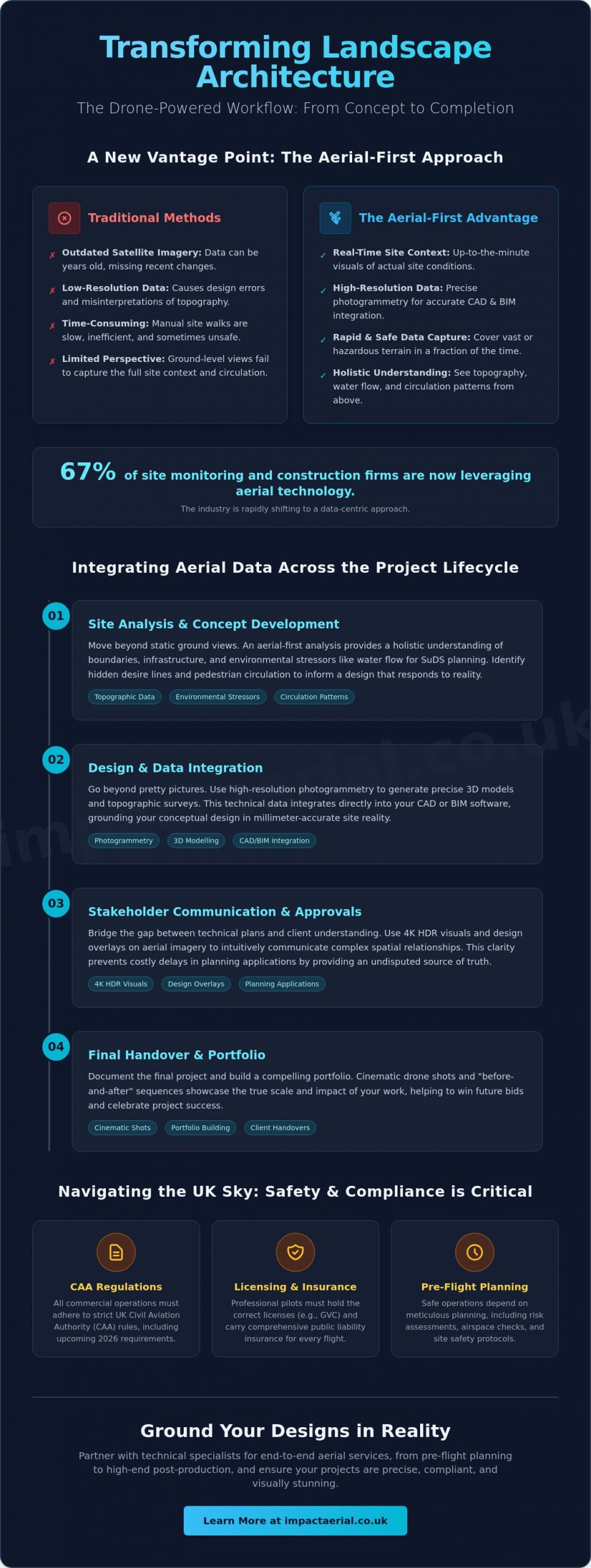
How much time does your practice lose correcting design errors caused by the low-resolution, outdated perspective of satellite imagery? For many professionals, the gap between a digital map and the physical reality of a site is a constant source of friction. You already know that successful landscape architecture depends on absolute precision. Whether you’re assessing complex topography or trying to convey the true scale of a masterplan to a stakeholder, static 2D data often fails to tell the whole story. With 67% of site monitoring and construction firms now utilizing aerial technology, the industry is rapidly shifting toward a more data-centric approach to site analysis.
Professional drone photography for landscape architects changes this dynamic by providing a data-rich visual narrative that bridges the gap between conceptual design and site reality. By leveraging high-resolution aerial imagery and drone-derived surveys, you can transform your workflow from the first site visit to the final client pitch. You’ll discover how to integrate topographic data directly into your CAD or BIM software, capture cinematic portfolio shots that win bids, and stay ahead of the 2026 UK CAA regulatory requirements. This guide explains how to use aerial technology to ground your designs in reality while ensuring every flight is safe, insured, and compliant.
Key Takeaways
- Move from static ground-level perspectives to holistic aerial-first site analysis to better understand environmental stressors and site circulation.
- Integrate professional drone photography for landscape architects into your full project lifecycle to enhance site analysis, concept development, and final handover.
- Distinguish between simple marketing imagery and technical data collection, including how photogrammetry supports precise CAD and BIM integration.
- Ensure project safety and legal compliance by understanding the specific CAA regulations and licensing required for commercial drone operations in the UK.
- Streamline your workflow by partnering with technical specialists for end-to-end services, from pre-flight planning to high-end post-production editing.
The New Vantage Point: Why Landscape Architects are Adopting Drone Photography in 2026
Landscape design in 2026 requires more than a simple aesthetic vision; it demands a precise, technical understanding of the land. Professional drone photography for landscape architects has evolved into a sophisticated toolset that captures high-resolution visual data and georeferenced information. This technology marks a departure from traditional ground-level site analysis. Instead of relying on restricted views from the perimeter, architects now adopt an aerial-first methodology. This shift allows for a holistic understanding of site boundaries, neighboring infrastructure, and environmental stressors that are invisible from the ground.
To see how this technology transforms a site’s visual narrative, watch this helpful video:
One of the most significant advantages is the move away from outdated satellite imagery. Standard digital maps often rely on data that is years old, failing to account for recent construction or vegetation changes. Drones provide real-time site context, which is critical for 2026 Sustainable Drainage Systems (SuDS) planning. By identifying natural water flow paths and existing drainage bottlenecks from above, designers can create more resilient landscape interventions that respond to the actual conditions of the terrain.
The Evolution of the Site Visit
Manual site measurements often involve days of walking the terrain with tape measures and handheld cameras. Professional drone services significantly reduce this timeframe. Using high-specification DJI Enterprise hardware, pilots can capture comprehensive data across sprawling or hazardous terrain that would be unsafe for manual inspection. This efficiency doesn’t sacrifice the “genius loci” of a project. Aerial perspectives reveal the spirit of a place by highlighting how light, shadow, and topography interact across the entire site simultaneously, providing a perspective that was previously impossible to document.
Bridging the Gap Between Concept and Reality
Architects often struggle to explain complex spatial relationships to clients who can’t read a technical 2D plan. Aerial views provide an intuitive bridge. By showing a proposed design overlaid on high-resolution Photogrammetry data, stakeholders see exactly how the project fits into the wider environment. This clarity is vital for planning applications, where documenting “before” conditions with precise imagery can prevent costly delays. In 2026, site context is defined as a fusion of 4K HDR visuals and GPS-tagged data that provides a single, undisputed source of truth for the entire design team.
From Concept to Completion: Enhancing the Design Workflow with Aerial Imagery
Integrating drone photography for landscape architects into a project’s lifecycle provides a consistent data stream that links conceptual ideas to physical outcomes. While the previous section highlighted the initial vantage point, the true value lies in how this imagery evolves through the design stages. During site analysis, aerial views reveal circulation patterns and environmental stressors that are often invisible from the ground. You can observe how pedestrians interact with existing boundaries or identify hidden desire lines that should inform your new layout. This high-level perspective ensures your design responds to actual human behavior rather than static assumptions.
Site Analysis and Environmental Context
Before the first sketch is drawn, a comprehensive drone survey establishes a baseline of existing conditions. High-resolution imaging allows you to map tree canopies and vegetation with centimeter-level precision, which is essential for biodiversity net gain assessments. Thermal sensors can also detect drainage issues or specific micro-climates by identifying areas of moisture retention or heat concentration. This technical data informs more accurate feasibility studies, reducing the risk of expensive design changes later in the process. When operating in these complex environments, we always adhere to UK Civil Aviation Authority drone regulations to ensure site safety and legal compliance.
Client Presentations and Emotional Buy-in
Winning approval for a visionary masterplan requires more than technical drawings. It demands an emotional connection. Using a professional aerial filming drone, you can produce cinematic narratives that guide stakeholders through the proposed space. By overlaying 3D renders onto actual 4K HDR site photos, you create “verified view” montages that demonstrate the project’s real-world impact. This level of visual fidelity is often the deciding factor in winning high-value commercial tenders or securing planning permission from local authorities. If you want to elevate your next proposal, consider how professional aerial filming can articulate your design intent.
The workflow doesn’t end at the construction phase. Drones provide an efficient way to monitor progress and document “as-built” conditions. These final records are invaluable for long-term maintenance contracts, providing a clear visual map of underground services, irrigation systems, and planting layouts before they are covered by growth. This comprehensive documentation ensures that designers using drone photography for landscape architects can provide clients with a precise record of the completed works, ensuring the design vision is maintained throughout the project’s operational life.
Beyond the ‘Pretty Picture’: Photogrammetry and 3D Modelling for Site Analysis
While high-resolution visuals win pitches, the true engineering value of drone technology lies in its ability to generate measurable, actionable data. Professional drone photography for landscape architects has transitioned from simple visual documentation to precise technical collection. This shift moves the drone from the marketing department into the core design team. By capturing data that is georeferenced and scaled, we provide a foundation for precision engineering that traditional photography lacks. It’s no longer just about the view; it’s about the data that lives within the image.
Achieving this level of precision requires specific hardware and expertise. By utilizing a specialized survey drone equipped with Real-Time Kinematic (RTK) technology, we achieve centimetre-level accuracy that standard consumer drones cannot replicate. These data sets integrate seamlessly into AutoCAD, Revit, and BIM workflows. This allows for a “single source of truth” where architects, engineers, and contractors all work from the same high-fidelity model. This integration reduces errors during the construction phase and ensures that the final build aligns perfectly with the initial site analysis, saving both time and project budget.
Understanding Photogrammetry and Point Clouds
Photogrammetry involves processing hundreds of overlapping high-resolution images into a cohesive 3D model. This process creates a digital twin of the landscape, including existing structures, vegetation, and terrain features. From this data, we generate high-density point clouds and topographic maps that are essential for accurate grading and drainage planning. Point clouds allow architects to measure distances and volumes directly from their desktop, eliminating the need for repeated site visits to verify minor measurements. This digital approach to site analysis provides a level of detail that ground-based surveys often miss, especially in large-scale masterplanning projects.
LiDAR vs. Photogrammetry for Landscape Design
Choosing the correct sensor is a matter of technical necessity and project scale. For most landscape projects, photogrammetry provides excellent visual detail and sufficient accuracy for design purposes. However, when a project involves penetrating thick canopy or dense undergrowth to understand the underlying topography, LiDAR (Light Detection and Ranging) becomes essential. LiDAR sensors emit laser pulses that “see” through gaps in foliage to map the true ground surface. Impact Aerial utilizes DJI Enterprise sensors to deliver high-fidelity data across both methods. As discussed in A Guide to Drones for Landscape Architects, understanding these technical differences is key to selecting the right service for your project’s specific environmental challenges. We provide the technical consultancy needed to ensure you receive the most cost-effective data for your specific site requirements.
Navigating the UK Sky: Compliance, CAA Regulations, and Risk Management
Safety is the primary concern for any professional architecture practice. While the visual benefits of drone photography for landscape architects are undeniable, the operational risks must be managed through strict adherence to UK aviation law. Commissioning an unlicensed pilot doesn’t just risk a fine; it places your entire firm at a significant liability disadvantage. Professional drone operations require a methodical approach to risk management that hobbyist flights simply cannot provide. This ensures that every flight over a project site is conducted with the same level of professional oversight as the design work itself.
The Importance of CAA GVC Certification
For commercial work in congested urban areas, a pilot must hold a specific drone license known as the General Visual Line of Sight Certificate (GVC). This qualification demonstrates that the operator has undergone rigorous training and assessment approved by the Civil Aviation Authority. Unlike hobbyists, GVC-certified pilots are authorised to operate in complex environments, provided they follow a documented Operations Manual. At Impact Aerial, we combine this certification with £5m commercial liability insurance as standard. This level of coverage is essential for architecture firms to protect against third-party risks during site visits or construction monitoring. We don’t just fly; we execute a meticulous flight plan that includes airspace checks, weather monitoring, and emergency protocols for every mission.
Data Privacy and Public Relations
Filming in public or residential spaces introduces complex GDPR and privacy considerations. A professional operator acts as a liaison between your project and the local community. We manage the legal requirements for data capture, ensuring that any identifiable information is handled according to current privacy laws. As of January 2026, new UK Remote ID requirements mean that most commercial drones must broadcast their identity and location in real-time. This increases transparency and accountability, making it even more vital to use compliant hardware and registered operators. Our pilots are trained to communicate effectively with local authorities and the public, maintaining the professional reputation of your firm while capturing the data you need.
Adhering to these regulations ensures your project data is legally defensible and safe to use in public pitches or planning applications. If you are planning a project in a high-density area, our Drone Commercial Property Surveys provide the compliant, high-resolution data required to move your design forward without regulatory friction.
Every mission begins with a comprehensive risk assessment. For urban landscape projects, this involves identifying potential hazards such as overhead power lines, public footpaths, and restricted airspace. By documenting these factors before the drone leaves the ground, we eliminate the uncertainty that often surrounds aerial data collection. This disciplined approach to safety is what separates professional drone photography for landscape architects from casual aerial snapshots, providing you with psychological comfort and tangible project benefits.
Partnering for Precision: Professional Drone Services for Landscape Design Projects
Impact Aerial acts as a technical extension of your design practice. While some firms consider a DIY approach, the opportunity cost of an architect attempting to become a full-time pilot is often overlooked. Professional drone photography for landscape architects requires more than just owning a device; it demands continuous technical training, hardware maintenance, and strict regulatory compliance. By partnering with us, you can remain focused on design and client engagement while we handle the complexities of flight operations and data processing.
We utilise professional-grade DJI Enterprise hardware that far exceeds the capabilities of consumer models. These systems are designed for stability in varied weather conditions and carry superior sensors that deliver the high-fidelity data required for professional site analysis. Our end-to-end service covers everything from pre-flight safety planning to sophisticated post-production editing. This ensures you receive assets that are ready for immediate use in your design presentations or technical reports.
Why Hire a Professional Drone Service?
The primary advantage of outsourcing is cost-efficiency. You avoid the significant overheads associated with specialist commercial insurance, hardware depreciation, and the annual fees for pilot certifications. Our team provides quality assurance through guaranteed 4K HDR output and meticulously processed technical data that aligns with your project standards. Whether you’re managing a small residential garden or a massive urban regeneration project, we provide the scalability to meet your specific project requirements without you needing to invest in additional internal resources.
Getting Started with Impact Aerial
Our process begins with a detailed consultation to match the right sensor and flight plan to your specific design goals. We don’t just capture images; we provide data in formats that are ready for integration into your AutoCAD, Revit, or BIM software. This ensures a seamless transition from our aerial data collection to your digital design environment. We invite you to view our portfolio of drone photography tailored specifically for the built environment to see the quality of our output first-hand.
The final stage of our partnership involves delivery and comprehensive support. Our post-production services ensure that every video or survey is polished and professional, reflecting the high standards of your architectural practice. If you’re ready to enhance your workflow with precise, data-rich imagery, contact us today for a bespoke quote for your next landscape project.
Elevating Your Design Workflow with Precision Aerial Data
Adopting an aerial-first approach to site analysis is no longer a luxury for modern practices; it’s a technical necessity for those who demand precision and efficiency. By transitioning from static satellite maps to real-time, high-resolution data, you ensure that every design decision is grounded in the physical reality of the site. We’ve explored how professional drone photography for landscape architects bridges the gap between conceptual sketches and as-built accuracy, providing a single source of truth for your entire design team. This data-rich visual narrative doesn’t just win client pitches; it mitigates risk throughout the project lifecycle.
Impact Aerial provides the technical expertise and operational security your projects deserve. Our CAA GVC Certified Pilots utilise DJI Enterprise Grade Hardware to deliver centimetre-level accuracy while maintaining £5m Commercial Liability Insurance for your peace of mind. We handle the complexities of UK aviation regulations so you can focus on creating resilient, visionary landscapes. If you’re ready to transform your site analysis with high-fidelity imagery and technical surveys, request a bespoke drone photography quote for your landscape project today. We look forward to supporting your next project with the precision it requires.
Frequently Asked Questions
Do I need a special license to use drone photography for my landscape architecture firm?
Yes, any commercial use of drones in the UK requires specific registration and, in most professional cases, a qualification from the Civil Aviation Authority (CAA). You must have an Operator ID and the pilot must hold a Flyer ID. For projects in congested areas or near people, a General Visual Line of Sight Certificate (GVC) is legally required to ensure the operation remains compliant with safety standards.
Can drone data be integrated into AutoCAD or Revit for site analysis?
Professional drone data is designed for seamless integration with industry-standard design software. We provide processed outputs such as georeferenced orthomosaics in .TIFF format and 3D point clouds in .LAS or .OBJ formats. These files allow you to overlay high-resolution site context directly onto your existing CAD drawings or BIM models, ensuring your design is built upon an accurate digital twin of the landscape.
What is the difference between photogrammetry and a standard aerial photo?
A standard aerial photo is a single, static image used primarily for visual reference or marketing. Photogrammetry is a technical process that uses hundreds of overlapping images to create a measurable 3D model. While a photo shows you what a site looks like, photogrammetry provides a data-rich environment where you can calculate volumes, distances, and precise elevation changes across the entire project area.
How much does professional drone photography for a landscape project cost in the UK?
The cost of drone photography for landscape architects depends on several technical factors, including the size of the site, the complexity of the airspace, and the specific data outputs required. A simple visual progress shoot involves different planning requirements than a full topographic survey with RTK accuracy. You should check with a professional operator for a bespoke quote that accounts for your specific project scale and location.
Is it safe to fly drones on busy urban construction sites?
It is safe to fly in complex urban environments when you use a pilot who follows strict CAA-approved risk management protocols. We use DJI Enterprise hardware equipped with 360-degree obstacle avoidance and redundant systems to maintain flight stability. Every mission on a busy site is preceded by a detailed risk assessment to identify hazards such as cranes, power lines, and public footpaths, ensuring the safety of all personnel on the ground.
What happens if it rains on the day of the scheduled drone shoot?
We monitor weather forecasts meticulously and will typically postpone a flight if rain or high winds exceed the safe operating limits of the hardware. High-quality data collection requires clear visibility and stable conditions to ensure the 4K visuals and technical sensors perform optimally. If a shoot is cancelled due to weather, we work closely with your team to reschedule for the next available clear window to avoid project delays.
How long does it take to receive the processed 3D models or edited footage?
Standard aerial photography and unedited video files are typically delivered within 24 to 48 hours of the flight. More complex datasets, such as processed 3D point clouds or topographic maps, require significant computational time and usually take three to five working days to complete. We provide these files via secure digital transfer, ensuring your design team can begin using the data as quickly as possible.
Can drones help with tree surveys and TPO (Tree Preservation Order) assessments?
Drones are highly effective tools for assessing vegetation and managing Tree Preservation Orders across large sites. High-resolution imagery allows for the precise mapping of tree canopies and the identification of specific species from an inaccessible vantage point. This data provides a clear visual record of tree health and position, which is invaluable when submitting planning applications or conducting biodiversity net gain assessments for sensitive landscape projects.
