
How to Get a Drone Filming Permit in the UK: 2026 Guide

Could one missing permission stop an otherwise compliant drone shoot? It can. If you’re researching how to get a drone filming permit uk, start by knowing there isn’t one universal permit for every flight and filming location. CAA requirements govern where and how a drone may fly; landowner access and location-specific approvals are separate parts of the plan.

A pilot’s CAA credentials don’t settle every permission question, and a location booking doesn’t automatically clear the airspace. The checks depend on the planned operation, aircraft, airspace and where you intend to launch, land and film. Missing one can delay a shoot or force a change of plan.

This guide explains how to identify the permissions relevant to your project, what information to prepare for the CAA, local authorities or landowners, and how to keep flight approval separate from site access. It also shows how to build those checks into a filming schedule, so production planning starts with a clear view of the requirements.

Key Takeaways

  • There isn’t one universal UK drone filming permit. Learn how to get a drone filming permit uk by identifying the separate flight, location and launch-access permissions your project may need.
  • Match the planned flight to the relevant CAA operating category and authorisation route. Filming for business doesn’t create a separate permit category.
  • Separate permission to film at a location from approval to fly in the airspace, and account for local variations in council processes.
  • Prepare key project details, including the date, site, launch point, aircraft, flight area, crew and activity, before approaching the relevant authorities or landowners.
  • See how professional flight planning supports production, with Impact Aerial’s CAA GVC-certified pilots and £5m commercial liability insurance.

How to get a drone filming permit in the UK: understand the permissions first

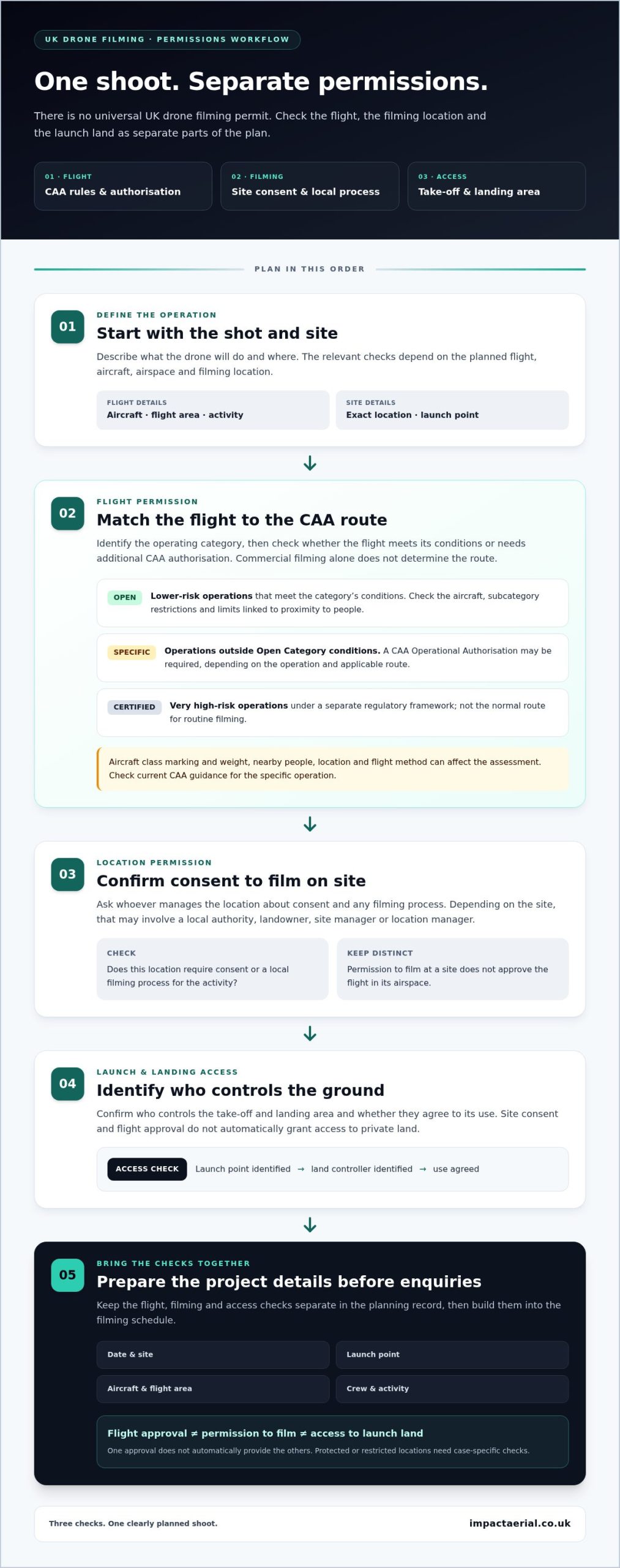
The permissions for a UK drone shoot depend on the proposed flight, location and filming activity. There isn’t one document that clears every part of a production: aviation requirements, consent to film at a site, and access to the land used for take-off and landing are separate checks.

A practical answer to “how to get a drone filming permit uk” starts with defining the shot. For an orbit around a privately owned building, for example, the operator must assess whether the flight can take place under the applicable CAA rules. The production may also need the owner’s consent to film on site and permission to use a suitable launch area. One approval doesn’t automatically provide the others.

A drone shoot may need more than one permission because approval to fly, consent to film and access to launch land address different risks and rights.

Is there one UK-wide drone filming permit?

No. There isn’t a single UK-wide drone filming permit that automatically grants every necessary approval. The CAA regulates aviation safety, and the flight must follow the operating rules and authorisation route that apply to it. Separately, a site owner or manager may set conditions for filming on their property, and a local authority may have its own process for filming in a managed public location.

The applicable route depends on the aircraft, planned flight and site. A straightforward shoot in an open area may raise different aviation and access questions from filming near people, buildings or restricted airspace. Check current CAA guidance for the proposed operation rather than assuming commercial filming always requires a particular authorisation. Commercial purpose alone isn’t a universal trigger for a separate CAA permit.

Who may be involved in approving a drone shoot?

Start with the CAA for aviation requirements. Depending on the site and how it is managed, location enquiries may also involve a local authority, landowner, site manager or location manager. The person who can consent to filming may not control the airspace, just as flight approval doesn’t grant permission to enter private land or launch from it.

Protected or restricted locations need case-specific checks. Restrictions and contacts can vary, so identify the exact site and flight area before making assumptions. Confirm who manages the launch point and whether separate location arrangements apply to the filming activity.

For a clear planning record, keep these three questions distinct:

  • Flight: What CAA rules and any operational or airspace permissions apply to this specific flight?
  • Filming: Does the location require consent or a local filming process for the activity?
  • Access: Who controls the take-off and landing area, and have they agreed to its use?

These checks work together, but they aren’t interchangeable. Establishing them early helps identify the right contacts and prevents a location booking, land-access agreement or pilot credential from being treated as blanket approval for the shoot.

CAA drone rules for filming: check the flight category and authorisation

The CAA’s rules are based on the risk of the operation, not simply whether footage is made for a client or payment. First identify the applicable operating category, then check whether the flight meets that category’s conditions or needs additional CAA authorisation. The aircraft’s class marking and weight, the people nearby, the location and how the drone will be flown can all affect the assessment.

The CAA permission route depends on the operation’s risk and the rules that apply to it.

Operating category What it means for planning
Open For lower-risk operations that meet the category’s conditions. Check the aircraft and applicable subcategory restrictions, including limits linked to proximity to people.
Specific For operations that fall outside the Open Category conditions. A CAA Operational Authorisation may be required, depending on the operation and applicable route.
Certified For very high-risk operations, subject to a separate regulatory framework. It is not the normal route for routine filming.

This comparison is a starting point, not approval to fly. UK drone class markings and rules can affect the route, and legacy aircraft may be subject to different operating restrictions. Check current CAA guidance for the specific aircraft and flight rather than relying on a category label alone.

When might a drone operator need CAA authorisation?

Additional authorisation may be needed if the proposed operation cannot be conducted within the applicable Open Category conditions. A shot planned close to people or in a constrained setting, for example, may need a different operating assessment from a flight in a clear, open area. The location, aircraft and operating method all matter. Commercial filming is not, by itself, the test for whether authorisation is required.

Before fixing the shot, check current CAA requirements for the intended flight, including any relevant separation rules and airspace restrictions. If the flight needs an authorisation, its conditions shape what the pilot can safely and lawfully do on the day.

What do operator ID, flyer ID and GVC mean?

An Operator ID identifies the person or organisation responsible for managing a drone, while a Flyer ID demonstrates that a flyer has passed the required theory test. Current CAA rules set requirements according to factors such as aircraft weight and whether it has a camera. Under the 2026 requirements, a Flyer ID applies from 100g, and an Operator ID is required from 100g for a camera-equipped drone; drones from 250g to 25kg require both.

A GVC is a remote-pilot qualification relevant to certain operations and permission routes. It is not a universal filming permit. CAA terminology and qualification routes are changing, with RPC-L1 replacing GVC as the entry point for more complex operations, so check the current route before planning. For a fuller explanation of UK drone licensing and CAA rules, review the requirements alongside the planned flight. Productions that need flight planning and aerial footage handled together can also explore professional aerial filming and photography.
How to Get a Drone Filming Permit in the UK: 2026 Guide

Location filming permission and drone launch access: what to check

A location booking doesn’t automatically provide permission to launch a drone, and access to a launch site doesn’t establish that the flight is permitted. Treat filming consent, ground access and aviation requirements as separate workstreams, then coordinate them around the same shot plan. This distinction is central to how to get a drone filming permit uk without mistaking one approval for another.

A production might have consent to film inside a privately managed estate but still need the landowner or site manager to agree to take-off and landing from a particular area. The flight must also comply with the relevant CAA rules. Even an accessible launch point may be unsuitable, so the operator needs to consider whether it supports a safe, compliant flight.

Do you need permission to take off or land?

Arrange permission for the specific land used for take-off and landing, including any recovery point that differs from the launch site. This may involve a private landowner, venue, site manager or another party responsible for the ground. Agree where the crew can set up, how the area will be used and whether the planned activity fits the site’s conditions.

That consent covers access to land, not permission to conduct the flight. CAA requirements still apply independently, and permission to fly doesn’t grant access to private property. Keep both decisions documented with the shoot plan.

How do council and location filming processes differ?

Local filming arrangements depend on who manages the site and the planned activity. A council, film office or location manager may handle requests through its own process, and requirements for a managed public space may differ from those for private premises. Ask the authority responsible for that location what information and approvals it requires; don’t assume one council’s process applies elsewhere.

Film London provides filming information for London, while FilmFixer supports location filming processes in areas it serves. These are location-filming resources, not aviation regulators. Their guidance may help identify location contacts, but it doesn’t replace CAA checks or land-access consent. Dorset is another reminder that filming arrangements are location-specific: check the relevant council or site manager rather than applying a London process across the UK.

Before confirming the location, check the exact launch and landing points, the site boundary and any restrictions that may affect filming. Protected places and restricted locations can have additional considerations, so identify the responsible authority or site body and verify applicable requirements directly. Allow time in the production schedule for responses and conditions, such as limits on where the crew can work.

  • Identify the decision-makers: Separate the site owner or manager from the local filming contact and aviation authority.
  • Describe the activity clearly: Provide the filming date, take-off and landing locations, intended flight area and crew activity.
  • Record conditions: Keep written access consent and location requirements with the flight plan, and review any changes to the site or shot before filming.

Clear coordination helps prevent an approved location from being mistaken for an approved flight, or an accessible field from being treated as permission to use it.

How to apply for drone filming permission in the UK: a project checklist

A clear application starts with a defined shot, not a generic request to “film by drone”. Set out what you plan to capture, where the aircraft will launch and land, and how the flight fits the location. The steps below turn how to get a drone filming permit uk into a practical sequence, while allowing for different authorities to request different information.

  • 1. Define the shot. Describe the intended footage, the activity being filmed and the proposed flight area. Note any movement, people or site features that affect how the operation will be planned.
  • 2. Fix the location and date. Identify the site, its boundaries and the intended filming date or dates. If the schedule is flexible, say so rather than implying a date is approved.
  • 3. Mark launch and recovery points. Record the areas proposed for take-off and landing, and identify who controls that land. Include an alternative point only if it forms part of the plan.
  • 4. Identify the aircraft and pilot. Prepare the drone’s make, model and relevant class or weight details, alongside the pilot’s information and qualifications relevant to the planned operation.
  • 5. Check the flight area. Review current CAA requirements and airspace information for the site and proposed flight. Identify restrictions or additional permissions that may apply, and verify them with the responsible authority.
  • 6. Contact the right parties. Send location requests to the organisation managing the site, land-access requests to the landowner or site manager, and aviation queries or applications through the relevant CAA route. Don’t assume one recipient handles every approval.
  • 7. Confirm before committing the crew. Keep responses, conditions and the agreed flight plan together. Confirm they still match the planned date, aircraft, launch point and activity.

What information should a filming permission request include?

Give each receiving body the information relevant to its decision. A location request should explain the project purpose, proposed dates, site boundaries and filming activity. For an aviation assessment, include the aircraft, pilot details, intended flight area and practical safety controls suited to the operation and site. A clear plan helps the recipient understand the request without having to infer what the crew intends to do.

Provide evidence of relevant pilot qualifications, authorisations or insurance if requested. Requirements and forms vary, so follow the current instructions for each application rather than sending the same incomplete pack to every party.

What should happen before the shoot day?

Before deployment, confirm written permissions and access arrangements with the relevant parties, then make sure any conditions are reflected in the flight plan. Recheck the weather, current restrictions and site conditions, since a changed environment or schedule can affect whether the planned operation remains suitable. Keep a named production contact and a practical contingency plan available to the crew.

Approval times and documentation depend on the authority, location and operation. Build realistic time for enquiries and responses into the schedule without assuming a fixed turnaround. For productions that need coordinated flight planning and footage delivery, plan professional aerial filming with Impact Aerial, from initial project support through post-production.

Plan compliant drone filming with a professional UK aerial team

Once you’ve mapped out the permission checks, the next challenge is delivering the planned shots within the applicable approvals and site conditions. A professional aerial team can coordinate flight preparation with the production brief, considering creative requirements alongside aircraft, location and operational constraints. The operator still needs to follow the relevant CAA rules and permissions on the day; hiring a filming team doesn’t replace those requirements.

Impact Aerial provides aerial filming and photography with CAA GVC-certified pilots, professional-grade commercial drones with 4K HDR cameras, and £5m commercial liability insurance. These credentials support a carefully planned shoot, while the specific flight route and permissions depend on the operation and location.

What does a professional drone filming workflow cover?

Project support can begin by scoping the footage needed, the intended setting and how aerial shots will fit the wider production. Shot planning and site coordination then help align the desired angles with practical launch access, the flight area and operating conditions. Whether the brief calls for a building reveal, a site overview or a moving sequence, consider each shot against the real location and approved flight plan, not just as a camera request.

Preparation also gives the production team a clearer view of the information and arrangements needed before filming. The workflow can continue through capture and post-production, connecting the original footage requirements to the final output. For context on how aerial work fits into broader commercial applications, see this professional drone services guide.

When is an experienced drone filming team useful?

An experienced team is useful when a production needs aerial footage but doesn’t want to manage aircraft operations as a separate workstream. The filming operator can coordinate flight preparation, crew activity and footage capture, while the production focuses on its wider schedule. Clear communication still matters: the team needs to understand the intended scenes and site conditions, and the production needs to allow the flight plan to guide what can be captured safely.

Impact Aerial supports projects from initial consultation through post-production. CAA GVC-certified pilots and £5m commercial liability insurance provide specific operational and insurance credentials, while 4K HDR equipment supports aerial capture. This connects planning, filming and delivery rather than leaving the production to piece together separate stages.

If your project needs aerial footage supported by professional planning and post-production, explore Impact Aerial’s drone filming services and see how the team can support your production brief.

Start shaping your aerial filming brief

Turn the intended result into a concise shot brief. Identify the images that matter most to the story, where they need to fit in the production, and what could change if the location or operating conditions limit a particular shot. This gives the filming team a useful creative starting point while leaving room to plan within the permissions and conditions that apply.

If you’re still working out how to get a drone filming permit uk for your project, bring the brief and proposed location into planning early. Aerial filming works best when the visual goal and practical flight plan are considered together, rather than treated as separate decisions at the last minute.

Impact Aerial supports productions from initial project planning through post-production, with CAA GVC-certified pilots, £5m commercial liability insurance and commercial-grade 4K HDR drone filming. Explore professional drone filming with Impact Aerial and take the next step towards planning aerial footage that fits your production.

Frequently Asked Questions

Is there one permit for drone filming in the UK?

No, there isn’t one universal document that clears every drone flight and filming location. Your shoot may involve separate CAA flight requirements, consent to film at a site and permission to access the launch or recovery area. A venue’s filming consent, for example, doesn’t by itself confirm that the planned flight is allowed. Check current CAA guidance and the relevant site or land authority for your specific plan.

Does commercial drone filming need a CAA permit?

Not solely because the filming is paid or for business use. The relevant CAA requirements depend on the operation, including the aircraft, flight conditions and risk involved. A planned shot near people, for example, may need a different assessment from one over an open area. Check current CAA guidance against the precise flight plan rather than treating commercial purpose as an automatic permit trigger.

Do I need permission to take off and land a drone on private land?

Arrange permission from the landowner or person managing the site before using private land for take-off or landing. This also applies if the drone will recover at a different point from where it launched. Confirm the access route, where the crew may set up and whether site conditions affect the shoot. Ground access consent is separate from the aviation requirements for the flight itself.

How do I apply for a drone filming permit in the UK?

Start by describing the intended shots, filming dates, site, aircraft and proposed flight area. Then identify who handles aviation questions, land access and location filming at that site. The phrase how to get a drone filming permit uk can suggest one application, but you may need to make separate enquiries and provide different information to each party. Keep responses together and confirm they match the final plan before filming.

Can I film with a drone in a public place in the UK?

Public access doesn’t automatically mean a drone can fly there. A busy public square, for instance, presents different operational considerations from a quiet open space, and the applicable CAA rules still apply. You may also need to identify who manages the location and whether filming or launch access has site-specific conditions. Check current flight requirements and contact the responsible authority before treating the location as suitable.

Does a CAA GVC certificate give me permission to film anywhere?

No. A GVC is a pilot qualification relevant to certain operational routes, not blanket approval for every flight or location. The operation must still meet applicable CAA requirements, and a site may have separate access or filming conditions. A qualified pilot may still need permission to use a private launch area, for example. Check the current CAA route for the planned operation, especially as qualification terminology and pathways evolve.

How long does it take to get permission for a drone filming shoot?

There’s no single approval timeframe for every UK shoot. Timing can depend on the operation, the location’s process, which organisations need to respond and whether they request more information. A shoot involving several locations may require separate enquiries, each with its own steps. Start the permission process before locking in the production schedule, allow flexibility for responses and don’t treat an acknowledgement or booking as final approval.
Drone Virtual Tour Services: The Complete Guide to Immersive Aerial Experiences in 2026

If your property marketing relies on static ground-level shots, you aren’t just missing the view; you’re losing the true scale of the entire investment. It’s frustrating when standard photography fails to capture the full footprint of a large-scale development or complex industrial site, leaving potential stakeholders guessing about the layout. You need a way to provide context and depth that traditional lenses simply cannot reach.

We understand that while the visual potential of aerial data is exciting, the logistics of drone virtual tour services can feel daunting. You might worry about the complexities of 2026 UK CAA regulations or wonder how to safely integrate high-resolution 360° panoramas into your website without compromising performance. This guide is designed to provide professional clarity and reassurance. You’ll discover how high-precision aerial data transforms site inspections and marketing into immersive, interactive experiences.

We’ll walk you through the essential technical requirements, from using commercial-grade DJI Enterprise hardware to ensuring your project is backed by CAA GVC certified pilots and £5m commercial liability insurance. By the end of this article, you’ll know exactly how to leverage these digital twins to mitigate business risk, increase engagement, and maintain full regulatory compliance across the UK.

Key Takeaways

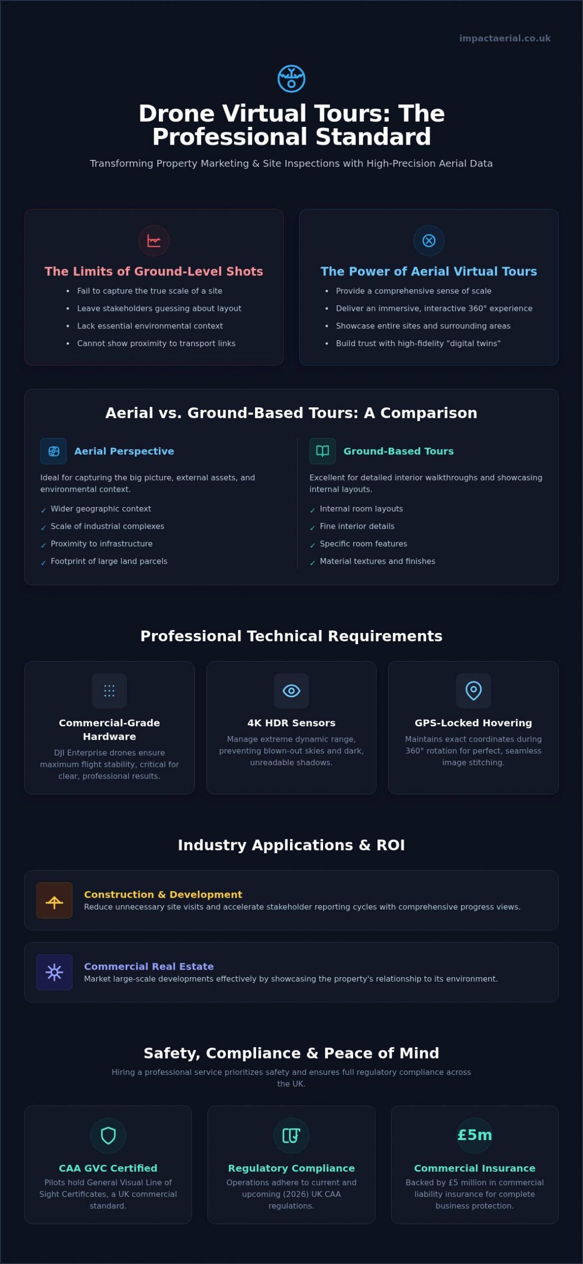
  • Discover how interactive, 360-degree aerial environments provide a comprehensive sense of scale that standard ground-level photography simply cannot match.
  • Learn why professional-grade hardware, including 4K HDR sensors and GPS-locked stability, is critical for creating high-precision digital twins of your assets.
  • Evaluate the specific use cases for aerial perspectives versus ground-based tours to ensure you’re using the most effective visual tool for your property.
  • See how industries like construction and commercial real estate use these assets to reduce unnecessary site visits and accelerate stakeholder reporting cycles.
  • Understand the business value of hiring professional drone virtual tour services that prioritize safety through CAA GVC certification and £5m public liability insurance.

The Evolution of Property Perspectives: What Are Drone Virtual Tour Services?

Professional drone virtual tour services have redefined how stakeholders interact with physical assets. Unlike a standard aerial photograph that provides a single fixed perspective, a virtual tour is a dynamic, interactive 360-degree environment. Users can rotate their view, zoom in on specific details, and navigate between multiple vantage points across a site. In 2026, these assets have shifted from being high-end marketing novelties to essential digital infrastructure for property developers, surveyors, and site managers.

The realism of these tours depends heavily on the use of high-resolution 4K HDR imagery. This technology ensures that lighting remains consistent across the entire spherical capture, preventing the “blown-out” skies or dark shadows often seen in amateur attempts. By providing a seamless, high-fidelity experience, businesses can offer a level of transparency that builds immediate trust with remote investors and project partners. It’s about delivering a digital twin that feels as tangible as a physical site visit.

How 360° Aerial Imaging Differs from Ground Tours

Ground-based tours are excellent for internal room layouts, but they lack the ability to show a property in its wider geographic context. Aerial imaging provides unrestricted vantage points that ground cameras simply cannot reach. This perspective is vital for showing the scale of industrial complexes or the proximity of a development to critical transport links. It’s a balance between the “wow factor” of a sweeping view and the practical data required for site analysis. You aren’t just looking at a building; you’re understanding its relationship with the surrounding environment.

Key advantages of the aerial perspective include:

  • Unrestricted Vantage Points: Capturing views from heights and angles impossible for tripod-mounted cameras.
  • Contextual Awareness: Showing the surrounding infrastructure, access roads, and neighbouring sites in a single view.
  • Scale Perception: Providing a true sense of the footprint for large land parcels or multi-building estates.

The Technology Behind the Immersion

Capturing these environments requires meticulous flight planning and commercial-grade hardware. The use of DJI Enterprise drones ensures maximum stability during the 360-degree rotation. This stability is crucial for the post-production stage, where individual images are stitched together to create a fluid, navigable interface. Many advanced tours now incorporate photogrammetry techniques to add depth and measurable data to the visual experience. These tours can be integrated into existing platforms like Matterport or delivered via custom-coded web overlays, ensuring they fit perfectly into your current digital workflow.

Technical Requirements for Professional Aerial Virtual Tours

High-quality drone virtual tour services rely on a sophisticated stack of hardware and software to deliver usable, high-fidelity data. It isn’t just about capturing a series of images; it’s about maintaining absolute visual consistency across a 360-degree panorama. To achieve this, we utilize 4K HDR sensors that manage the extreme dynamic range found in aerial environments. These sensors prevent the “blown-out” highlights in the sky and the loss of detail in shadowed areas on the ground. Precision is further maintained through GPS-locked hovering. This ensures the aircraft remains at an exact coordinate while rotating, allowing for perfect image alignment during the stitching process.

Compatibility is another critical technical hurdle. In 2026, a professional tour must be fully responsive. It should perform seamlessly whether a stakeholder is viewing it on a mobile device in the field, a desktop in the office, or through a VR headset for a fully immersive experience. Delivering this level of performance requires optimized hosting solutions that prioritize speed without sacrificing the resolution of the 360-degree environment.

Hardware Matters: Why Consumer Drones Aren’t Enough

Consumer-grade aircraft often lack the flight stability required for commercial projects, especially on UK coastal or hilltop sites where wind speeds are unpredictable. Professional DJI Enterprise drones provide the motor power and advanced flight controllers necessary to hold a steady position in challenging conditions. This stability is essential for preventing motion blur and ensuring that every frame of the 360-degree capture is sharp. Furthermore, the increased sensor size on enterprise models provides the dynamic range needed to produce professional results in varied lighting conditions. Larger battery capacities also ensure we can cover massive commercial footprints in a single session, reducing the need for frequent landings and battery swaps.

Post-Production and Hosting

The raw data captured in the field undergoes a rigorous post-production process to create a cinematic and professional finish. This involves “zenith patching” to digitally reconstruct the sky where the drone’s own hardware would be visible, as well as the careful removal of the drone’s shadow from the ground. These meticulous edits maintain the professional illusion of a floating, detached perspective. For projects requiring more than just a visual overview, we can add interactive hotspots. These links can connect the viewer to detailed drone survey data, site maps, or floor plans.

Safety remains the foundation of our technical workflow. Every flight is conducted in strict accordance with UK drone safety and compliance regulations. Our pilots are CAA GVC certified and we carry £5m in public liability insurance to mitigate risk on every project. If you need a technical partner for your next development, you can view our full range of aerial services to see how we deliver precision data across the UK.

Drone Virtual Tour Services: The Complete Guide to Immersive Aerial Experiences in 2026

Aerial vs. Ground-Based Tours: A Comparison Framework

Choosing between aerial and ground-based perspectives depends on the specific data requirements of your project. Ground-based solutions, such as Matterport, remain the industry standard for internal room layouts and high-detail floor plans. They allow a user to walk through a building at eye level, providing an intimate sense of space. However, these systems can’t capture the broader environment or the structural integrity of a roof. When you invest in drone virtual tour services, you’re securing a high-precision asset that bridges the gap between ground-level detail and bird’s-eye context.

The deployment process also varies significantly. Ground tours require physical access to every room, which is often time-consuming for expansive industrial complexes. In contrast, aerial tours require meticulous pre-flight planning and strict adherence to 2026 CAA regulations. Our CAA GVC certified pilots manage these legal complexities. They ensure that the data collection process is both compliant and safe. This technical expertise allows us to capture data that ground-based tripods simply can’t reach, especially in complex or hazardous environments.

When to Choose Aerial Virtual Tours

Aerial perspectives are the superior choice for roof inspections, land development, and large commercial assets. For high-end real estate, showing the neighbourhood context is often more valuable than seeing the interior alone. Stakeholders need to see the proximity to transport links, green spaces, and neighbouring infrastructure. Additionally, these services are vital for monitoring construction progress. By capturing the same coordinates over several months, we create time-lapse virtual tours that provide an undeniable record of site development. This level of remote monitoring reduces the need for frequent site visits, saving time and operational costs.

The Hybrid Approach: The Best of Both Worlds

For many 2026 projects, the most effective solution is a hybrid model. This involves transitioning seamlessly from an aerial fly-in to a ground-based 3D walkthrough. We often integrate high-fidelity aerial videography within these interactive tours to provide a cinematic introduction before the user begins their self-guided exploration. Based in Birmingham, we provide these hybrid solutions across the West Midlands and the wider UK. This unified approach ensures a professional user experience. It provides consistent branding across all marketing and survey assets. By combining these technologies, you provide a comprehensive digital twin that serves both marketing and technical reporting needs.

Maximising ROI: Industry-Specific Applications in 2026

Measuring the return on investment for aerial data requires looking beyond the initial visual impact. In 2026, drone virtual tour services have become high-precision instruments for risk mitigation and operational efficiency across several UK sectors. By providing a navigable, 360-degree environment, these assets allow stakeholders to conduct detailed site inspections from any location, significantly reducing the costs associated with travel and physical site access. Whether you’re managing a massive industrial footprint or a sensitive heritage site, the ability to remotely monitor conditions with 4K clarity provides a tangible competitive advantage.

In addition to commercial projects, tourism and heritage organisations use these digital twins to preserve and promote UK landmarks. These interactive environments allow the public to explore restricted or fragile areas without causing physical wear, supporting both conservation and educational outreach. For insurance and surveying purposes, this level of documentation is invaluable. It provides a meticulous record of site conditions that can be used for accurate risk assessment and the resolution of claims with objective, high-fidelity evidence.

Drone Virtual Tours for Construction Site Monitoring

The construction and AEC sectors benefit most from the transition toward “Digital Twins.” By capturing regular 360-degree aerial panoramas, project managers can track on-site progress against Building Information Modelling (BIM) data with high accuracy. This process isn’t just about documentation; it’s a critical safety tool. Using drones to inspect high-elevation structures reduces the requirement for personnel to work at height, directly lowering the risk profile of the project. Drone virtual tours act as a visual ‘time capsule’ for site audits, providing a permanent, verifiable record of every project phase.

High-End Property and Marketing

In the competitive commercial and residential markets, cinematic aerial perspectives create an emotional connection that ground-level shots cannot replicate. Integrating these tours with professional real estate photography allows developers to differentiate their listings on crowded property portals. We’ve seen that immersive content significantly increases time-on-site for prospective buyers, as they can explore the neighbourhood context and site boundaries at their own pace. This transparency speeds up the sales cycle by filtering out less-interested parties before a physical viewing is even scheduled.

From our base in Birmingham, we help businesses across the West Midlands and the wider UK turn aerial data into actionable business assets. If you’re ready to enhance your project reporting or property marketing, you can book our professional drone services to start building your digital twin today.

Safety, Compliance, and Choosing a Professional UK Provider

Operating a drone commercially in the UK is a highly regulated activity. In 2026, the Civil Aviation Authority (CAA) maintains strict standards to ensure public safety and airspace security. For any business commissioning drone virtual tour services, checking for a General Visual Line of Sight Certificate (GVC) is the first step in due diligence. This certification isn’t just a badge; it’s proof that the pilot has undergone rigorous theoretical and practical assessments to operate safely in complex environments. Without this, your project is legally non-compliant from the moment the rotors spin.

Risk mitigation is another cornerstone of professional operations. While a hobbyist might offer lower rates, they often lack the necessary £5m commercial public liability insurance required for industrial or commercial sites. This insurance protects your business from the financial consequences of accidental damage or injury. Beyond insurance, a professional provider conducts comprehensive pre-flight planning and site-specific risk assessments. This meticulous preparation identifies potential hazards like overhead power lines, restricted flight zones, or high-density pedestrian areas before the aircraft even leaves the ground.

Privacy and data protection are equally critical. Aerial photography naturally captures the surrounding area, which may include private residences or individuals. A compliant provider adheres to strict GDPR protocols, ensuring that any identifiable data is handled legally or redacted during the post-production phase. This commitment to privacy protects your brand from potential legal challenges and ensures your digital assets remain a benefit rather than a liability for your organisation.

The Impact Aerial Standard

Based in Birmingham, we provide specialized expertise across the West Midlands while maintaining a robust UK-wide reach. Our approach to drone services is defined by a commitment to safety and technical precision. We manage every aspect of the project, from the initial airspace consultation to the final 360-degree edit. This end-to-end management ensures that your virtual tour is not only visually stunning but also fully compliant with the latest 2026 aviation standards.

Vetting Your Drone Service Provider

Hiring an uncertified pilot is a significant liability that can result in heavy fines or voided insurance policies. A “hobbyist” pilot simply cannot provide the level of operational security required for a commercial contract. Use this checklist to ensure your provider meets professional standards:

  • CAA GVC Certification: Verify the pilot’s current credentials and Operator ID.
  • Commercial Insurance: Confirm a minimum of £5m public liability coverage.
  • Specialized Hardware: Ensure they use commercial-grade DJI Enterprise drones for stability.
  • Data Portfolio: Review previous 360-degree projects for quality and consistency.

If you’re ready to elevate your property marketing or site monitoring with a trusted partner, contact Impact Aerial for a consultation today. We provide the technical expertise and regulatory reassurance you need for a successful aerial project.

Securing Your Competitive Advantage through Aerial Data

The transition from static aerial photography to interactive digital twins represents a fundamental shift in how UK businesses monitor assets and market high-value properties. By integrating high-precision 360° data with professional post-production, you provide stakeholders with a transparent, immersive experience that builds immediate trust. Technical success depends on high-fidelity sensors and strict adherence to the 2026 CAA regulatory framework.

Choosing professional drone virtual tour services ensures your project is handled with the meticulous care it deserves. Impact Aerial provides a specialized, safety-first approach to every flight. We are Birmingham based but offer UK-wide coverage, supported by CAA GVC certified pilots and £5m commercial liability insurance. This combination of local expertise and national reach allows us to deliver high-end results that mitigate business risk while maximizing engagement.

If you’re ready to transform your property perspectives and streamline your site reporting, our team is prepared to assist. Take the first step toward creating a high-precision digital asset for your business today. Request a Professional Drone Virtual Tour Quote

Frequently Asked Questions

Are drone virtual tours legal in urban areas like Birmingham?

Yes, provided the operator holds the correct CAA certifications. We operate regularly in Birmingham and across the UK using CAA GVC certified pilots. Legal urban flight requires meticulous planning, risk assessments, and adherence to specific distance requirements from people and property. By following the 2026 UK drone regulations, we manage all necessary permissions and airspace notifications to ensure your drone virtual tour services remain fully compliant and safe in built-up environments.

How much do drone virtual tour services cost in the UK?

Pricing for professional drone virtual tour services depends on several project-specific factors. These include the total number of 360-degree capture points required, the complexity of the airspace, and any post-production requirements like interactive hotspots or custom branding. While basic packages exist for smaller properties, large-scale commercial sites require bespoke quotes. We recommend discussing your specific deliverables with a certified provider to receive an accurate estimate tailored to your site’s unique operational needs and data requirements.

What is the difference between a 360 drone photo and a virtual tour?

A 360 drone photo is a single spherical image that allows a user to look in every direction from one fixed point. In contrast, a virtual tour is an interactive environment composed of multiple 360-degree images linked together. This allows users to move through the site by clicking on navigation points. A tour provides a navigable, comprehensive digital twin of the entire property rather than just a single panoramic view captured from the air.

Can I view drone virtual tours on my mobile phone?

Yes, all professional tours are designed to be fully responsive across mobile devices, tablets, and desktops. We use optimized hosting solutions that ensure the 4K HDR imagery loads quickly without compromising resolution on smaller screens. Many tours also support gyro-navigation; this means the view moves as you rotate your phone, providing a more intuitive experience. This cross-platform compatibility is essential for stakeholders who need to access immersive site data while working in the field.

How long does it take to capture a drone virtual tour for a commercial site?

The time required for on-site data capture varies based on the size and complexity of the property. For a standard commercial site, the flight operations typically take between two and four hours. This includes the time needed for pre-flight safety checks and capturing multiple 360-degree panoramas at various heights. Larger industrial complexes or multi-building construction sites may require a full day of operation to ensure every critical vantage point is documented with technical precision.

Do I need special software to host a drone virtual tour on my website?

You don’t need any specialized software on your own server to host a tour. We typically provide a simple embed code or a direct URL that works just like a YouTube video or an interactive map. The tour is hosted on a high-performance, dedicated server that handles all the data-heavy processing. This approach ensures that your website remains fast and responsive while providing users with a seamless, high-resolution immersive experience without technical overhead.

What happens if the weather is bad on the day of the shoot?

Safety is our primary concern, so we monitor weather forecasts meticulously leading up to the project date. If high winds or heavy rain make flight operations unsafe or compromise image quality, we’ll reschedule the shoot for the next available clear day. Our commercial DJI Enterprise drones can handle moderate conditions, but we prioritize optimal lighting and stability to ensure your virtual tour meets our high-fidelity quality standards without putting people or property at risk.

Is a drone virtual tour better than standard aerial photography?

It isn’t necessarily better, but it serves a different purpose. Standard aerial photography is excellent for high-impact marketing images and fixed technical reports. However, a virtual tour provides an interactive, navigable perspective that allows stakeholders to explore the site at their own pace. For complex site monitoring or remote inspections, the ability to zoom in and rotate the view provides significantly more context and data than a series of static images alone.

Drone Photography for Landscape Architects: Enhancing Design and Site Analysis

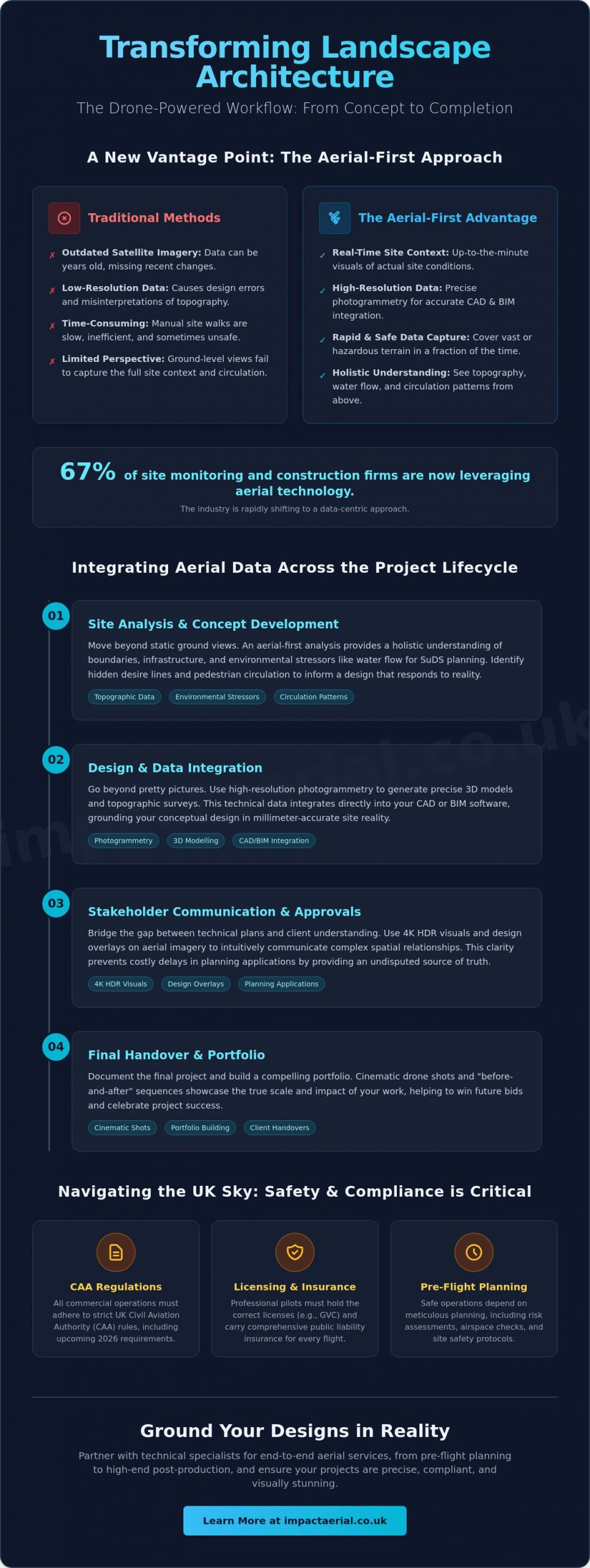
How much time does your practice lose correcting design errors caused by the low-resolution, outdated perspective of satellite imagery? For many professionals, the gap between a digital map and the physical reality of a site is a constant source of friction. You already know that successful landscape architecture depends on absolute precision. Whether you’re assessing complex topography or trying to convey the true scale of a masterplan to a stakeholder, static 2D data often fails to tell the whole story. With 67% of site monitoring and construction firms now utilizing aerial technology, the industry is rapidly shifting toward a more data-centric approach to site analysis.

Professional drone photography for landscape architects changes this dynamic by providing a data-rich visual narrative that bridges the gap between conceptual design and site reality. By leveraging high-resolution aerial imagery and drone-derived surveys, you can transform your workflow from the first site visit to the final client pitch. You’ll discover how to integrate topographic data directly into your CAD or BIM software, capture cinematic portfolio shots that win bids, and stay ahead of the 2026 UK CAA regulatory requirements. This guide explains how to use aerial technology to ground your designs in reality while ensuring every flight is safe, insured, and compliant.

Key Takeaways

  • Move from static ground-level perspectives to holistic aerial-first site analysis to better understand environmental stressors and site circulation.
  • Integrate professional drone photography for landscape architects into your full project lifecycle to enhance site analysis, concept development, and final handover.
  • Distinguish between simple marketing imagery and technical data collection, including how photogrammetry supports precise CAD and BIM integration.
  • Ensure project safety and legal compliance by understanding the specific CAA regulations and licensing required for commercial drone operations in the UK.
  • Streamline your workflow by partnering with technical specialists for end-to-end services, from pre-flight planning to high-end post-production editing.

The New Vantage Point: Why Landscape Architects are Adopting Drone Photography in 2026

Landscape design in 2026 requires more than a simple aesthetic vision; it demands a precise, technical understanding of the land. Professional drone photography for landscape architects has evolved into a sophisticated toolset that captures high-resolution visual data and georeferenced information. This technology marks a departure from traditional ground-level site analysis. Instead of relying on restricted views from the perimeter, architects now adopt an aerial-first methodology. This shift allows for a holistic understanding of site boundaries, neighboring infrastructure, and environmental stressors that are invisible from the ground.

To see how this technology transforms a site’s visual narrative, watch this helpful video:

One of the most significant advantages is the move away from outdated satellite imagery. Standard digital maps often rely on data that is years old, failing to account for recent construction or vegetation changes. Drones provide real-time site context, which is critical for 2026 Sustainable Drainage Systems (SuDS) planning. By identifying natural water flow paths and existing drainage bottlenecks from above, designers can create more resilient landscape interventions that respond to the actual conditions of the terrain.

The Evolution of the Site Visit

Manual site measurements often involve days of walking the terrain with tape measures and handheld cameras. Professional drone services significantly reduce this timeframe. Using high-specification DJI Enterprise hardware, pilots can capture comprehensive data across sprawling or hazardous terrain that would be unsafe for manual inspection. This efficiency doesn’t sacrifice the “genius loci” of a project. Aerial perspectives reveal the spirit of a place by highlighting how light, shadow, and topography interact across the entire site simultaneously, providing a perspective that was previously impossible to document.

Bridging the Gap Between Concept and Reality

Architects often struggle to explain complex spatial relationships to clients who can’t read a technical 2D plan. Aerial views provide an intuitive bridge. By showing a proposed design overlaid on high-resolution Photogrammetry data, stakeholders see exactly how the project fits into the wider environment. This clarity is vital for planning applications, where documenting “before” conditions with precise imagery can prevent costly delays. In 2026, site context is defined as a fusion of 4K HDR visuals and GPS-tagged data that provides a single, undisputed source of truth for the entire design team.

From Concept to Completion: Enhancing the Design Workflow with Aerial Imagery

Integrating drone photography for landscape architects into a project’s lifecycle provides a consistent data stream that links conceptual ideas to physical outcomes. While the previous section highlighted the initial vantage point, the true value lies in how this imagery evolves through the design stages. During site analysis, aerial views reveal circulation patterns and environmental stressors that are often invisible from the ground. You can observe how pedestrians interact with existing boundaries or identify hidden desire lines that should inform your new layout. This high-level perspective ensures your design responds to actual human behavior rather than static assumptions.

Site Analysis and Environmental Context

Before the first sketch is drawn, a comprehensive drone survey establishes a baseline of existing conditions. High-resolution imaging allows you to map tree canopies and vegetation with centimeter-level precision, which is essential for biodiversity net gain assessments. Thermal sensors can also detect drainage issues or specific micro-climates by identifying areas of moisture retention or heat concentration. This technical data informs more accurate feasibility studies, reducing the risk of expensive design changes later in the process. When operating in these complex environments, we always adhere to UK Civil Aviation Authority drone regulations to ensure site safety and legal compliance.

Client Presentations and Emotional Buy-in

Winning approval for a visionary masterplan requires more than technical drawings. It demands an emotional connection. Using a professional aerial filming drone, you can produce cinematic narratives that guide stakeholders through the proposed space. By overlaying 3D renders onto actual 4K HDR site photos, you create “verified view” montages that demonstrate the project’s real-world impact. This level of visual fidelity is often the deciding factor in winning high-value commercial tenders or securing planning permission from local authorities. If you want to elevate your next proposal, consider how professional aerial filming can articulate your design intent.

The workflow doesn’t end at the construction phase. Drones provide an efficient way to monitor progress and document “as-built” conditions. These final records are invaluable for long-term maintenance contracts, providing a clear visual map of underground services, irrigation systems, and planting layouts before they are covered by growth. This comprehensive documentation ensures that designers using drone photography for landscape architects can provide clients with a precise record of the completed works, ensuring the design vision is maintained throughout the project’s operational life.

Drone Photography for Landscape Architects: Enhancing Design and Site Analysis

Beyond the ‘Pretty Picture’: Photogrammetry and 3D Modelling for Site Analysis

While high-resolution visuals win pitches, the true engineering value of drone technology lies in its ability to generate measurable, actionable data. Professional drone photography for landscape architects has transitioned from simple visual documentation to precise technical collection. This shift moves the drone from the marketing department into the core design team. By capturing data that is georeferenced and scaled, we provide a foundation for precision engineering that traditional photography lacks. It’s no longer just about the view; it’s about the data that lives within the image.

Achieving this level of precision requires specific hardware and expertise. By utilizing a specialized survey drone equipped with Real-Time Kinematic (RTK) technology, we achieve centimetre-level accuracy that standard consumer drones cannot replicate. These data sets integrate seamlessly into AutoCAD, Revit, and BIM workflows. This allows for a “single source of truth” where architects, engineers, and contractors all work from the same high-fidelity model. This integration reduces errors during the construction phase and ensures that the final build aligns perfectly with the initial site analysis, saving both time and project budget.

Understanding Photogrammetry and Point Clouds

Photogrammetry involves processing hundreds of overlapping high-resolution images into a cohesive 3D model. This process creates a digital twin of the landscape, including existing structures, vegetation, and terrain features. From this data, we generate high-density point clouds and topographic maps that are essential for accurate grading and drainage planning. Point clouds allow architects to measure distances and volumes directly from their desktop, eliminating the need for repeated site visits to verify minor measurements. This digital approach to site analysis provides a level of detail that ground-based surveys often miss, especially in large-scale masterplanning projects.

LiDAR vs. Photogrammetry for Landscape Design

Choosing the correct sensor is a matter of technical necessity and project scale. For most landscape projects, photogrammetry provides excellent visual detail and sufficient accuracy for design purposes. However, when a project involves penetrating thick canopy or dense undergrowth to understand the underlying topography, LiDAR (Light Detection and Ranging) becomes essential. LiDAR sensors emit laser pulses that “see” through gaps in foliage to map the true ground surface. Impact Aerial utilizes DJI Enterprise sensors to deliver high-fidelity data across both methods. As discussed in A Guide to Drones for Landscape Architects, understanding these technical differences is key to selecting the right service for your project’s specific environmental challenges. We provide the technical consultancy needed to ensure you receive the most cost-effective data for your specific site requirements.

Safety is the primary concern for any professional architecture practice. While the visual benefits of drone photography for landscape architects are undeniable, the operational risks must be managed through strict adherence to UK aviation law. Commissioning an unlicensed pilot doesn’t just risk a fine; it places your entire firm at a significant liability disadvantage. Professional drone operations require a methodical approach to risk management that hobbyist flights simply cannot provide. This ensures that every flight over a project site is conducted with the same level of professional oversight as the design work itself.

The Importance of CAA GVC Certification

For commercial work in congested urban areas, a pilot must hold a specific drone license known as the General Visual Line of Sight Certificate (GVC). This qualification demonstrates that the operator has undergone rigorous training and assessment approved by the Civil Aviation Authority. Unlike hobbyists, GVC-certified pilots are authorised to operate in complex environments, provided they follow a documented Operations Manual. At Impact Aerial, we combine this certification with £5m commercial liability insurance as standard. This level of coverage is essential for architecture firms to protect against third-party risks during site visits or construction monitoring. We don’t just fly; we execute a meticulous flight plan that includes airspace checks, weather monitoring, and emergency protocols for every mission.

Data Privacy and Public Relations

Filming in public or residential spaces introduces complex GDPR and privacy considerations. A professional operator acts as a liaison between your project and the local community. We manage the legal requirements for data capture, ensuring that any identifiable information is handled according to current privacy laws. As of January 2026, new UK Remote ID requirements mean that most commercial drones must broadcast their identity and location in real-time. This increases transparency and accountability, making it even more vital to use compliant hardware and registered operators. Our pilots are trained to communicate effectively with local authorities and the public, maintaining the professional reputation of your firm while capturing the data you need.

Adhering to these regulations ensures your project data is legally defensible and safe to use in public pitches or planning applications. If you are planning a project in a high-density area, our Drone Commercial Property Surveys provide the compliant, high-resolution data required to move your design forward without regulatory friction.

Every mission begins with a comprehensive risk assessment. For urban landscape projects, this involves identifying potential hazards such as overhead power lines, public footpaths, and restricted airspace. By documenting these factors before the drone leaves the ground, we eliminate the uncertainty that often surrounds aerial data collection. This disciplined approach to safety is what separates professional drone photography for landscape architects from casual aerial snapshots, providing you with psychological comfort and tangible project benefits.

Partnering for Precision: Professional Drone Services for Landscape Design Projects

Impact Aerial acts as a technical extension of your design practice. While some firms consider a DIY approach, the opportunity cost of an architect attempting to become a full-time pilot is often overlooked. Professional drone photography for landscape architects requires more than just owning a device; it demands continuous technical training, hardware maintenance, and strict regulatory compliance. By partnering with us, you can remain focused on design and client engagement while we handle the complexities of flight operations and data processing.

We utilise professional-grade DJI Enterprise hardware that far exceeds the capabilities of consumer models. These systems are designed for stability in varied weather conditions and carry superior sensors that deliver the high-fidelity data required for professional site analysis. Our end-to-end service covers everything from pre-flight safety planning to sophisticated post-production editing. This ensures you receive assets that are ready for immediate use in your design presentations or technical reports.

Why Hire a Professional Drone Service?

The primary advantage of outsourcing is cost-efficiency. You avoid the significant overheads associated with specialist commercial insurance, hardware depreciation, and the annual fees for pilot certifications. Our team provides quality assurance through guaranteed 4K HDR output and meticulously processed technical data that aligns with your project standards. Whether you’re managing a small residential garden or a massive urban regeneration project, we provide the scalability to meet your specific project requirements without you needing to invest in additional internal resources.

Getting Started with Impact Aerial

Our process begins with a detailed consultation to match the right sensor and flight plan to your specific design goals. We don’t just capture images; we provide data in formats that are ready for integration into your AutoCAD, Revit, or BIM software. This ensures a seamless transition from our aerial data collection to your digital design environment. We invite you to view our portfolio of drone photography tailored specifically for the built environment to see the quality of our output first-hand.

The final stage of our partnership involves delivery and comprehensive support. Our post-production services ensure that every video or survey is polished and professional, reflecting the high standards of your architectural practice. If you’re ready to enhance your workflow with precise, data-rich imagery, contact us today for a bespoke quote for your next landscape project.

Elevating Your Design Workflow with Precision Aerial Data

Adopting an aerial-first approach to site analysis is no longer a luxury for modern practices; it’s a technical necessity for those who demand precision and efficiency. By transitioning from static satellite maps to real-time, high-resolution data, you ensure that every design decision is grounded in the physical reality of the site. We’ve explored how professional drone photography for landscape architects bridges the gap between conceptual sketches and as-built accuracy, providing a single source of truth for your entire design team. This data-rich visual narrative doesn’t just win client pitches; it mitigates risk throughout the project lifecycle.

Impact Aerial provides the technical expertise and operational security your projects deserve. Our CAA GVC Certified Pilots utilise DJI Enterprise Grade Hardware to deliver centimetre-level accuracy while maintaining £5m Commercial Liability Insurance for your peace of mind. We handle the complexities of UK aviation regulations so you can focus on creating resilient, visionary landscapes. If you’re ready to transform your site analysis with high-fidelity imagery and technical surveys, request a bespoke drone photography quote for your landscape project today. We look forward to supporting your next project with the precision it requires.

Frequently Asked Questions

Do I need a special license to use drone photography for my landscape architecture firm?

Yes, any commercial use of drones in the UK requires specific registration and, in most professional cases, a qualification from the Civil Aviation Authority (CAA). You must have an Operator ID and the pilot must hold a Flyer ID. For projects in congested areas or near people, a General Visual Line of Sight Certificate (GVC) is legally required to ensure the operation remains compliant with safety standards.

Can drone data be integrated into AutoCAD or Revit for site analysis?

Professional drone data is designed for seamless integration with industry-standard design software. We provide processed outputs such as georeferenced orthomosaics in .TIFF format and 3D point clouds in .LAS or .OBJ formats. These files allow you to overlay high-resolution site context directly onto your existing CAD drawings or BIM models, ensuring your design is built upon an accurate digital twin of the landscape.

What is the difference between photogrammetry and a standard aerial photo?

A standard aerial photo is a single, static image used primarily for visual reference or marketing. Photogrammetry is a technical process that uses hundreds of overlapping images to create a measurable 3D model. While a photo shows you what a site looks like, photogrammetry provides a data-rich environment where you can calculate volumes, distances, and precise elevation changes across the entire project area.

How much does professional drone photography for a landscape project cost in the UK?

The cost of drone photography for landscape architects depends on several technical factors, including the size of the site, the complexity of the airspace, and the specific data outputs required. A simple visual progress shoot involves different planning requirements than a full topographic survey with RTK accuracy. You should check with a professional operator for a bespoke quote that accounts for your specific project scale and location.

Is it safe to fly drones on busy urban construction sites?

It is safe to fly in complex urban environments when you use a pilot who follows strict CAA-approved risk management protocols. We use DJI Enterprise hardware equipped with 360-degree obstacle avoidance and redundant systems to maintain flight stability. Every mission on a busy site is preceded by a detailed risk assessment to identify hazards such as cranes, power lines, and public footpaths, ensuring the safety of all personnel on the ground.

What happens if it rains on the day of the scheduled drone shoot?

We monitor weather forecasts meticulously and will typically postpone a flight if rain or high winds exceed the safe operating limits of the hardware. High-quality data collection requires clear visibility and stable conditions to ensure the 4K visuals and technical sensors perform optimally. If a shoot is cancelled due to weather, we work closely with your team to reschedule for the next available clear window to avoid project delays.

How long does it take to receive the processed 3D models or edited footage?

Standard aerial photography and unedited video files are typically delivered within 24 to 48 hours of the flight. More complex datasets, such as processed 3D point clouds or topographic maps, require significant computational time and usually take three to five working days to complete. We provide these files via secure digital transfer, ensuring your design team can begin using the data as quickly as possible.

Can drones help with tree surveys and TPO (Tree Preservation Order) assessments?

Drones are highly effective tools for assessing vegetation and managing Tree Preservation Orders across large sites. High-resolution imagery allows for the precise mapping of tree canopies and the identification of specific species from an inaccessible vantage point. This data provides a clear visual record of tree health and position, which is invaluable when submitting planning applications or conducting biodiversity net gain assessments for sensitive landscape projects.

