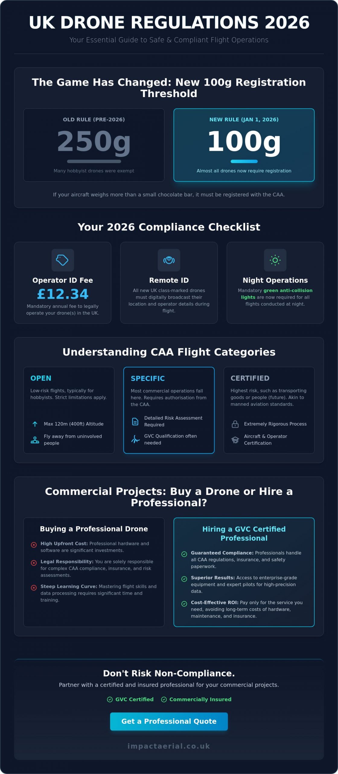
As of January 1, 2026, the threshold for mandatory UK drone registration has dropped to just 100g, effectively bringing almost every hobbyist and professional aircraft under strict CAA oversight. If you’re still operating under the old 250g mindset, you’re already out of compliance. We understand that the constant stream of new mandates, from Remote ID requirements to the £12.34 annual Operator ID fee, can feel overwhelming. You want to focus on capturing high-quality data, not deciphering complex legal frameworks or worrying about the risk of a costly hardware failure.
This guide provides the absolute clarity you need to master current technology and navigate 2026 UK CAA regulations with total confidence. We’ll help you understand the new UK0 to UK6 class markings and the mandatory green anti-collision lights required for night operations. You’ll also gain a practical framework for deciding between purchasing consumer-grade hardware or hiring a GVC certified professional for your specific commercial applications. By the end, you’ll have the knowledge to ensure every flight is safe, legal, and delivers the professional-grade results your project demands.
Key Takeaways
- Understand how the transition from consumer gadgets to sophisticated enterprise UAVs has redefined data-gathering capabilities for 2026.
- Clear the confusion surrounding UK CAA regulations by mastering the specific 2026 requirements for registration, class markings, and night flight compliance.
- Apply a strategic decision framework to determine if purchasing a professional drone or hiring a certified specialist offers the best ROI for your project.
- Explore how high-precision aerial imagery and site monitoring directly accelerate sales and improve project management efficiency in the property and construction sectors.
- Learn the critical criteria for vetting a professional aerial partner, ensuring they possess the GVC certification and commercial insurance required for legal operations.
What is a Drone? Understanding UAV Technology in 2026
An Unmanned Aerial Vehicle (UAV), commonly referred to as a drone, is a powered aircraft that operates without a human pilot on board. By 2026, these systems have moved far beyond their origins as recreational gadgets. They’ve become sophisticated data-gathering platforms that rely on a complex synergy of flight controllers, high-torque propulsion systems, and multi-constellation GPS modules. These components allow for sub-centimetre hovering accuracy even in challenging West Midlands weather conditions.
The shift from hobbyist toys to “Enterprise” tools is defined by the quality of the output. Modern professional drones carry advanced 4K High Dynamic Range (HDR) sensors as a baseline requirement. These sensors allow us to capture a broader spectrum of light and detail, which is essential for identifying minute structural cracks or creating high-fidelity 3D models. When you’re managing a multi-million pound construction project, the precision of this data isn’t just a luxury; it’s a critical safety and financial requirement.
To better understand how these components come together, watch this helpful video:
The Anatomy of a Modern Commercial Drone
Most commercial operations in 2026 utilise quadcopters due to their vertical take-off and landing (VTOL) capabilities. These are ideal for tight urban sites where space is limited. Fixed-wing UAVs remain the preferred choice for mapping massive infrastructure projects, such as rail networks or agricultural land, because of their superior battery efficiency. The payload is what truly differentiates a professional drone. While standard RGB cameras handle marketing imagery, thermal imaging sensors provide vital data for industrial heat-loss surveys. Intelligent flight modes and omni-directional obstacle sensing provide a digital safety net, ensuring the aircraft remains stable even if a sensor fails.
The Evolution of Drone Connectivity
Transmission technology has seen a significant leap with the integration of 5G and OcuSync 5.0. These systems provide a stable, high-definition video feed over distances exceeding 15km in optimal conditions. In the context of FPV drone flying in the UK, latency refers to the time delay between the drone’s camera capturing an image and that image appearing on the pilot’s goggles. For professional DJI Enterprise models, hardware redundancy is a core safety feature. Dual IMUs and compasses ensure that if one sensor experiences interference, the backup system takes over instantly. This level of reliability provides the peace of mind required for complex commercial missions.
UK Drone Laws and Regulations: Navigating the CAA Landscape
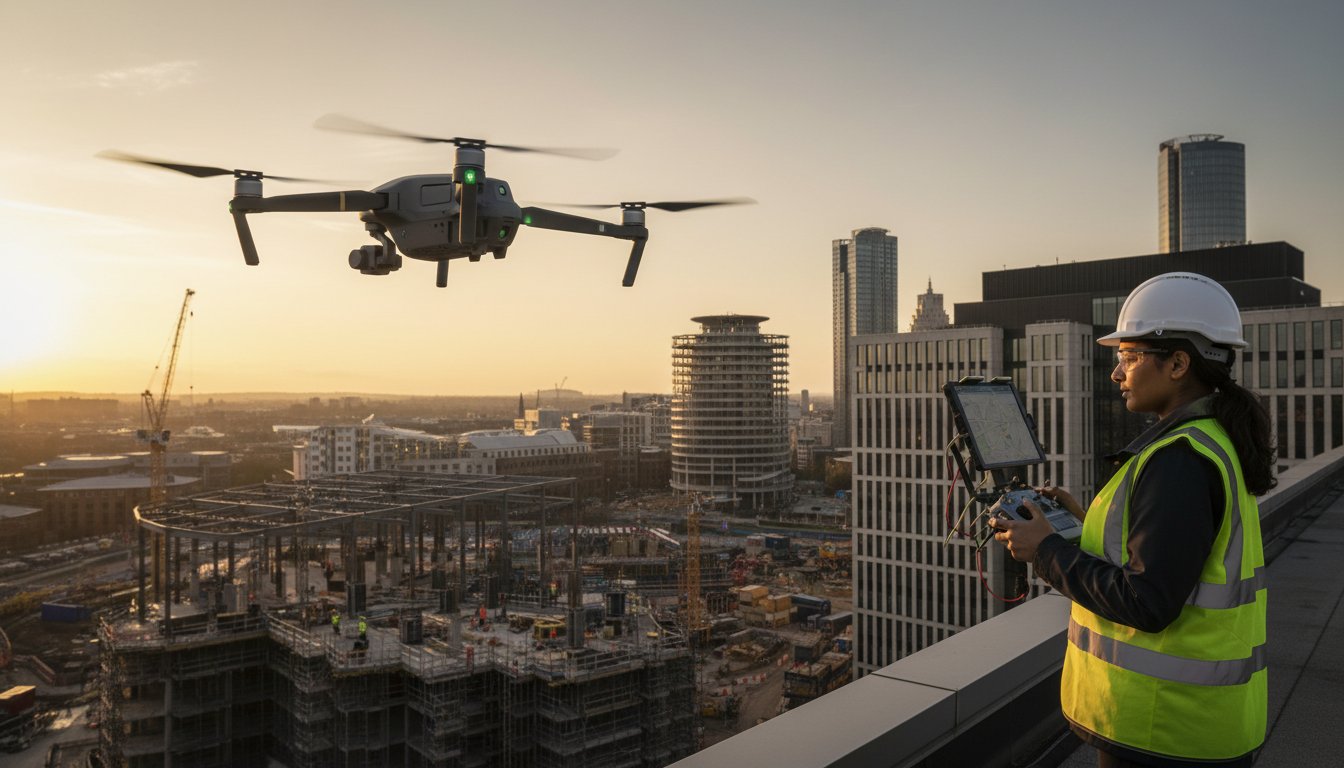
The Civil Aviation Authority (CAA) serves as the ultimate arbiter of safety within UK airspace. Their primary objective is to integrate unmanned aircraft into a sky shared with commercial airliners and emergency helicopters. Adhering to UK drone laws is no longer optional for hobbyists, especially since the January 1, 2026, mandate lowered the registration threshold to just 100g. If your aircraft weighs more than a chocolate bar, you must obtain a Flyer ID and pay the £12.34 annual Operator ID fee. This shift ensures every aircraft is traceable through Remote ID technology, which became mandatory for all new UK class-marked hardware on the same date.
The CAA divides flight operations into three distinct risk-based categories: Open, Specific, and Certified. Most hobbyist flights occur in the Open category, which has strict limits on altitude (120 metres) and proximity to uninvolved people. Commercial projects often push these boundaries, requiring a move into the Specific category. This is where “Fly Safe” transitions from a suggestion to a rigorous operational framework. It involves detailed pre-flight site assessments and strict adherence to the Drone Code to mitigate the risks associated with complex aerial data-gathering.
Professional Qualifications: A2 CofC vs GVC
The A2 CofC (Certificate of Competency) is a common starting point, allowing pilots to fly C2 class aircraft in urban areas. However, it has significant limitations regarding weight and distance from people. For complex commercial missions in Birmingham or the West Midlands, Impact Aerial utilizes pilots with the General Visual Line of Sight Certificate (GVC). This advanced qualification is required to obtain an Operational Authorisation from the CAA. A key component of this is the Operating Manual. This document is a comprehensive safety blueprint that details every procedure we follow, from emergency battery failure protocols to public safety cordons.
Commercial Drone Insurance and Liability
Standard consumer insurance policies almost never cover commercial activities. For any professional project, insurance must be compliant with EC 785/2004, which is a mandatory legal requirement for commercial operators in the UK. We maintain £5m in commercial liability insurance as a standard practice. This level of coverage is often a non-negotiable requirement for site access on major construction or infrastructure projects. It provides our clients with essential peace of mind, knowing that every aspect of the mission is financially protected. If you’re planning a project that requires this level of professional oversight, you can view our full range of certified drone services to ensure your site remains compliant.
Buying vs. Hiring: The Real Cost of Professional Drone Results
Deciding whether to invest in internal hardware or outsource to a specialist is a pivotal financial choice for UK businesses in 2026. While the barrier to entry for hobbyist gear is low, enterprise-grade equipment requires a significant capital expenditure. For example, a high-end aerial filming drone like the DJI Inspire 3 is currently priced at £13,419 excluding VAT. This initial cost only covers the airframe and basic accessories. It doesn’t account for the specialised lens sets or high-capacity storage required for professional cinematic output.
Hidden costs often catch internal departments by surprise. Professional drone operations require a robust ecosystem of support. This includes multiple intelligent flight battery sets, which often cost several hundred pounds each, and dedicated charging stations. You must also factor in mandatory annual maintenance, the £12.34 annual Operator ID fee, and expensive software subscriptions for photogrammetry or thermal analysis. When you consider the rapid pace of technological depreciation, the total cost of ownership for a single aircraft can be difficult to justify for occasional use.
For added peace of mind, hiring a professional team removes these financial risks and the liability of a potential hardware crash. A certified pilot brings more than just the aircraft; they bring years of experience in risk mitigation and technical data-gathering. This ensures your project stays on schedule and avoids the regulatory pitfalls that can result in heavy fines from the CAA.
When Buying Makes Sense
Investing in your own hardware is often the right choice for casual hobbyists or businesses with low-risk internal marketing needs. Sub-250g aircraft, such as the DJI Mini 5 Pro priced at approximately £689, offer a cost-effective way to capture basic aerial views without the stringent requirements of larger class-marked drones. However, these consumer-grade sensors often struggle in low-light conditions or during technical surveys where high-resolution data is paramount. If your requirements are limited to social media content or simple site progress shots, a small internal fleet might suffice.
Why Professional Drone Services Win for Business
Professional services provide immediate access to the latest DJI Innovations without the burden of ownership. This is particularly critical for a complex drone survey where sub-centimetre accuracy is required. As highlighted by Forbes, commercial applications for drones have expanded significantly into infrastructure and data analytics. A professional partner handles the entire workflow, from securing airspace permissions in restricted zones to processing raw data into actionable insights. This allows your team to focus on their core objectives while we manage the technical and regulatory complexities of the flight.
Commercial Applications: How Drones Drive Industry ROI
The UK drone market’s expansion, projected to reach a value of USD 2.7 billion by 2034, is fueled by a definitive shift toward industrial utility. In the competitive real estate sector, drone photography serves as a high-impact sales tool. It accounts for nearly 40% of the commercial application market share in 2026. High-quality aerial views provide a level of context that ground-level shots simply cannot match. This helps developers showcase the scale of large estates or the precise proximity of commercial units to West Midlands transport links, often accelerating the sales cycle for high-value listings.
Within the construction industry, construction site monitoring provides a consistent, digital record of project progress. This transparency reduces stakeholder disputes and keeps management teams informed through every phase of the build. Safety-related ROI is equally significant. By deploying a drone for roof inspections, businesses avoid the high costs and logistical delays associated with erecting scaffolding or hiring cherry pickers. This approach significantly minimises work-at-height risks, which remains a primary safety concern for UK site managers.
The energy sector also sees direct financial benefits through thermal surveys of PV solar farms. By identifying “hot spots” on individual panels, we can detect faulty cells that reduce a farm’s overall energy output. This allows for targeted maintenance rather than expensive, site-wide hardware audits. If you’re ready to see how these technologies can benefit your next project, you can contact our specialist team for a professional consultation.
Surveying and Data Collection
A professional survey drone equipped with RTK (Real-Time Kinematic) technology creates high-accuracy 2D orthomosaic maps and 3D point clouds. Land developers use these models for precise volume calculations and site planning, ensuring that earthworks are accurate to within centimetres. This level of data-gathering is essential for modern photogrammetry workflows. Thermal sensors add another layer of utility by detecting moisture ingress in flat roofs or electrical faults in industrial infrastructure before they escalate into costly repairs.
Aerial Filming and Creative Production
Creative production has been transformed by the ability to achieve cinematic “never-before-seen” angles that were previously only possible with expensive helicopter charters. These high-fidelity shots are integrated into professional post-production workflows to create high-impact marketing videos for the tourism and automotive industries. Beyond traditional video, virtual tour creation uses aerial data to build immersive experiences. This allows potential buyers to explore a development’s layout and surrounding views before ground is even broken on the site.
How to Choose a Professional Drone Partner in the UK
Selecting a professional drone partner is a high-stakes decision for any project manager. In 2026, the market is saturated with hobbyists, but commercial projects require a technical consultant rather than a casual pilot. You must distinguish between a “drone operator” who simply captures footage and a “data partner” who delivers actionable insights. A true data partner understands the nuances of photogrammetry and structural analysis, ensuring that the raw imagery captured on-site translates into meaningful ROI for your business.
Local expertise in Birmingham and the West Midlands is particularly vital for maintaining project timelines. Familiarity with regional airspace, such as the complex restricted zones around Birmingham Airport, ensures that operations proceed without legal delays or groundings. Local partners can also conduct rapid site visits, which is essential for construction monitoring where site conditions change within a 24-hour window. Reviewing a portfolio for specific industry experience is the final step; a pilot who excels at cinematic filming may not have the technical precision required for a high-accuracy topographical survey.
Vetting Qualifications and Insurance
Before signing any contract, insist on seeing a current CAA GVC certificate. This document proves the pilot has undergone the rigorous training required for missions in the Specific category. Confirm the pilot has a valid Flyer ID and a deep understanding of local airspace restrictions. For added peace of mind, verify their membership in professional bodies like ARPAS-UK or the Drone Safe Register. These affiliations act as a non-verbal signature of quality, indicating a commitment to the highest industry standards and safety protocols. You should also verify that their insurance schedule specifically covers the type of work they are performing on your site.
Impact Aerial: Your UK Partner for Drone Excellence
Our fleet includes the latest 4K HDR DJI Enterprise commercial drones, specifically chosen for their reliability and sensor quality. We maintain a meticulous approach to project management, ensuring every mission is compliant with the latest 2026 regulations and backed by comprehensive commercial liability insurance. Our commitment to precision and safety has established us as a leading specialist for property developers and industrial firms across the West Midlands. We provide more than just aerial views; we deliver the technical expertise required to solve complex business challenges. Contact Impact Aerial today for a professional consultation and discover how our aerial services can transform your next project.
Elevate Your Commercial Operations with Professional Aerial Insights
The landscape of aerial technology in 2026 is defined by precision and rigorous compliance. With the registration threshold now set at 100g and the mandatory broadcasting of Remote ID, operating a drone for commercial gain requires more than just technical skill; it demands a deep commitment to UK CAA standards. We’ve explored how moving beyond consumer-grade hardware to professional enterprise platforms can significantly drive ROI in sectors like construction and property development. High-quality data-gathering through photogrammetry and thermal surveys is now a baseline requirement for competitive industrial projects.
Choosing a partner who combines local Birmingham expertise with national reach ensures your projects remain compliant and efficient. Impact Aerial provides this added peace of mind through our team of CAA GVC Certified pilots and a robust £5m commercial liability insurance policy. We’re ready to help you navigate the complexities of 2026 regulations while delivering the breath-taking perspectives your business deserves. Request a Professional Drone Service Quote today to secure high-quality results for your next mission. Your project’s success starts with expert aerial intelligence.
Frequently Asked Questions
Do I need a license to fly a drone in the UK in 2026?
Yes, any pilot flying an aircraft weighing 100g or more must register with the CAA as of January 1, 2026. You’ll need a Flyer ID, obtained by passing a free online test, and an Operator ID which costs £12.34 per year. For commercial projects in urban areas, you’ll also need a GVC qualification and an Operational Authorisation to fly legally and safely.
Can I fly a drone in a city like Birmingham or London?
You can fly in major cities, but it’s highly restricted by Flight Restriction Zones and proximity rules for uninvolved people. London and Birmingham have complex airspace requirements due to international airports and government buildings. Professional operators handle the necessary CAA permissions and local risk assessments to ensure your urban project stays within the law and avoids heavy fines.
What happens if a drone crashes during a professional shoot?
If a crash occurs during a professional mission, the operator’s commercial liability insurance covers any third-party damages or injuries. Impact Aerial maintains £5m in coverage to comply with EC 785/2004 regulations, providing our clients with total peace of mind. This financial protection is a critical reason to hire certified professionals rather than relying on uncertified hobbyists who lack commercial-grade insurance.
How much does it cost to hire a professional drone survey team?
Hiring costs are determined by the project’s scale, the specific data output required, and the technical sensors used for the mission. While we don’t provide flat rates, we offer bespoke quotes based on your site’s location and the complexity of the flight plan. Contact us for a transparent assessment that reflects the expert certification and high-end enterprise hardware required for your specific project.
What is the difference between a consumer drone and an enterprise drone?
Enterprise models are technical tools featuring high-accuracy RTK positioning, thermal sensors, and redundant flight systems for industrial use. A consumer drone is typically designed for recreational photography and lacks the hardware reliability and data-gathering precision found in a professional fleet. Enterprise aircraft allow us to deliver sub-centimetre accuracy for surveys and structural inspections that consumer hardware simply cannot achieve.
Can drones fly in the rain or high winds?
Most professional aircraft can handle wind speeds up to 12-15 metres per second, but rain remains a significant operational risk. While some enterprise models have IP55 ratings for light moisture, we typically ground flights during heavy precipitation to protect the 4K HDR sensors. We monitor West Midlands weather patterns meticulously to ensure every flight is conducted in conditions that guarantee high-quality data and aircraft safety.
How long can a professional drone stay in the air?
A professional drone typically stays airborne for 30 to 45 minutes on a single high-capacity battery set. To ensure a seamless service on your site, we carry multiple intelligent batteries and field charging stations for continuous operation throughout the day. This methodical approach allows us to complete large-scale surveys or filming schedules without the delays associated with waiting for hardware to recharge.
Do I need permission from my neighbours to fly a drone over their house?
You don’t generally need a neighbour’s permission to fly through the airspace, but you must strictly comply with privacy laws and the CAA Drone Code. This code requires a 50-metre horizontal distance from uninvolved people and properties during the flight. Professional operators manage these legalities through detailed pre-flight planning and data protection policies to ensure every mission respects local privacy and GDPR requirements.
