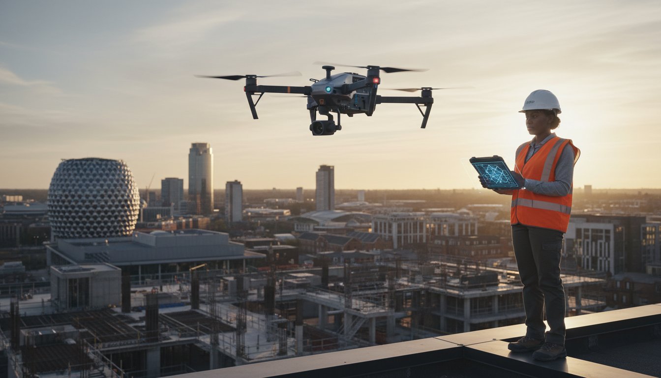
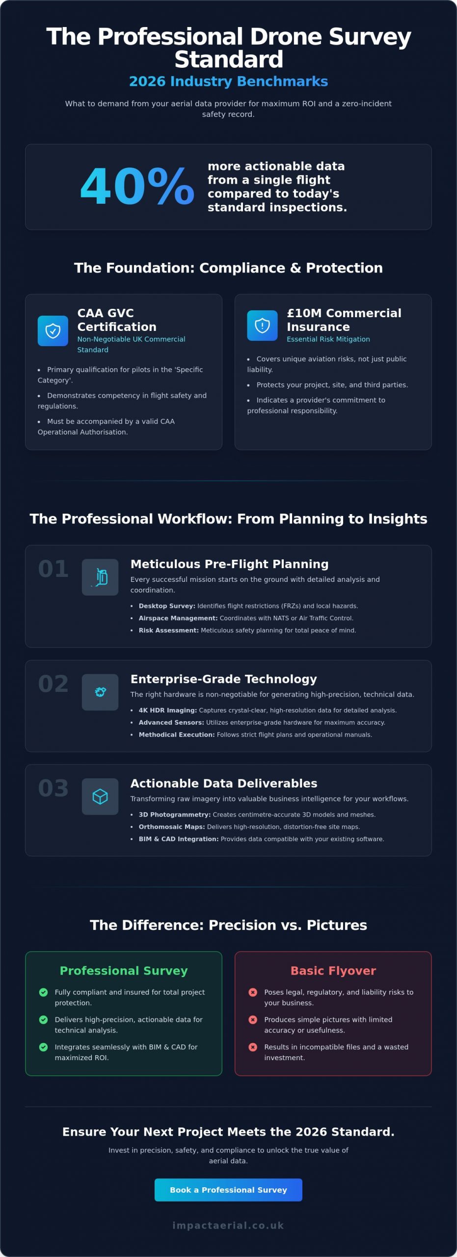
What if a single flight in 2026 could provide 40% more actionable data than today’s standard inspections while eliminating every regulatory headache? You likely agree that as the UK’s drone industry matures, the difference between a basic flyover and a professional technical survey has never been more critical. When you invest in aerial data, you’re looking for precision, not just pictures. Understanding what to expect from a drone survey provider is the first step in ensuring your site remains safe and your data remains compliant with the latest Civil Aviation Authority (CAA) standards.
We’ll show you the exact benchmarks for safety, insurance, and data quality you must demand to protect your business. For added peace of mind, we’ve detailed why GVC certification and £10 million in commercial liability insurance are non-negotiable standards. This guide previews the technical requirements and safety protocols that will define the industry in 2026, ensuring your next project delivers high-resolution results with a zero-incident safety record.
Key Takeaways
- Understand the legal necessity of CAA GVC certification and comprehensive commercial insurance to ensure your project remains fully compliant and protected.
- Learn exactly what to expect from a drone survey provider during the pre-flight phase, including essential airspace notifications and meticulous risk assessments for total peace of mind.
- Discover why enterprise-grade hardware and 4K HDR imaging are non-negotiable for generating the high-precision data required for technical site analysis.
- Explore how advanced data deliverables like 3D photogrammetry and orthomosaic maps can be seamlessly integrated into your existing BIM and CAD workflows.
- Identify the specific vetting criteria and regional expertise needed to maximise ROI when hiring specialists across Birmingham and the West Midlands.
The Professional Standard: Compliance, Certification, and Insurance
The UK drone industry in 2026 is no longer a niche market in its infancy; it’s a highly regulated field where safety and data precision are paramount. When considering what to expect from a drone survey provider, the first point of evaluation must be their adherence to Civil Aviation Authority (CAA) standards. A professional specialist isn’t just a hobbyist with a high-end camera. They’re technical consultants who use advanced tools for an unmanned aerial photogrammetric survey to deliver measurable business results.
Professionalism is defined by a meticulous approach to risk management. This involves detailed site assessments, pre-flight checklists, and a robust understanding of UK airspace restrictions. High-quality providers don’t just show up and fly. They integrate into your project workflow with a focus on safety and reliability, ensuring that every data-gathering mission is conducted within the legal framework of the UK’s “Specific Category” of operations.
To better understand the technical depth of these operations, watch this helpful video:
CAA Regulations and GVC Certification
By 2026, the transition from the old PfCO (Permission for Commercial Operation) to the GVC (General Visual Line of Sight Certificate) is complete. The GVC certification is the primary UK commercial standard for pilots operating in the Specific Category. It demonstrates a pilot’s competency in flight safety, meteorology, and regulatory knowledge. You can verify a pilot’s credentials through the Drone Safe Register to ensure they’re vetted and legal. If a provider cannot produce a valid GVC and an updated Operational Authorisation from the CAA, they aren’t a professional commercial entity.
Insurance and Risk Mitigation
Standard public liability insurance is insufficient for complex aerial work. Professional providers carry a minimum of £5m commercial liability insurance as an industry standard. This specific cover is essential because it accounts for the unique risks of aviation, protecting the client from third-party claims. For added peace of mind, this insurance is backed by a commitment to Airmanship and a strict adherence to the company’s CAA-approved Operations Manual. This level of protection is a key part of what to expect from a drone survey provider who takes their commercial responsibilities and your project’s safety seriously.
The Pre-Flight Phase: Meticulous Planning and Risk Assessment
A professional drone operation begins long before the propellers spin. When considering what to expect from a drone survey provider, the depth of their initial consultation is a primary indicator of quality. In 2026, providers focus on defining specific data outputs, whether that’s a centimetre-accurate 3D mesh or a high-resolution thermal map. This phase ensures the technology matches the project goals, preventing wasted site visits and ensuring the data is compatible with your existing BIM software or GIS platforms.
Meticulous planning involves more than just a calendar date. It requires a detailed analysis of the site’s unique characteristics and the specific requirements of the client. Whether you’re managing a 50-hectare development or a complex bridge inspection, the pre-flight phase sets the standard for the entire project’s success.
Desktop Surveys and Airspace Management
Safety is the cornerstone of every flight. Your provider will conduct a thorough desktop survey using digital tools to identify permanent and temporary flight restrictions. They’ll coordinate with NATS or local Air Traffic Control if the site sits within a Flight Restriction Zone (FRZ). A CAA GVC certified pilot manages these complexities, ensuring every flight is legal and coordinated. This level of preparation provides peace of mind that your project won’t face sudden shutdowns or legal complications from the Civil Aviation Authority. They’ll also check for local hazards like high-voltage power lines or microwave transmission towers that could interfere with drone telemetry.
RAMS: Risk Assessment and Method Statements
For construction and industrial sites, a robust RAMS document is non-negotiable. This document outlines how the team will manage ground safety, specifically during the critical take-off and landing phases. A professional provider will establish clear cordons and use spotters to manage public or site-worker incursions. This meticulous approach is part of the standard set by a qualified operator holding a valid uk drone license.
Beyond human factors, weather monitoring is constant. UK conditions can shift rapidly; therefore, providers use hyper-local forecasting to ensure wind speeds stay within the safe operating limits of their enterprise fleet. Most commercial drones are rated for winds up to 22 knots, but a professional provider will always build in a contingency plan. They’ll monitor the K-index for solar activity and local precipitation levels to ensure the sensors capture the highest quality data without risk to the equipment or the site. If you want to see how these safety standards translate into results, you can explore our professional survey solutions for your next project.
On-Site Operations: Enterprise Technology and Methodology
By 2026, the technical gap between consumer gadgets and enterprise-grade hardware is vast. When considering what to expect from a drone survey provider, the first indicator of quality is the equipment they deploy on-site. Professional operators use dedicated commercial fleets rather than standard retail models. These systems provide the stability and sensor quality required for millimetre-accurate technical analysis. Impact Aerial maintains a small operational footprint, ensuring we don’t disrupt your daily site activities while we capture 4K HDR video and high-resolution stills for your project records.
Commercial-Grade Hardware
Modern surveying demands more than just a camera in the air. We utilise the DJI Mavic 3 Enterprise series for its mechanical shutter and integrated RTK (Real-Time Kinematic) module. This technology delivers centimetre-level accuracy without the need for traditional ground control points. For complex environments, dual-operator setups allow one pilot to focus on flight safety while a second technician controls the sensor. This ensures every detail is captured. High-wind resistance is also vital. Our enterprise drones can operate safely in gusts up to 12 metres per second, preventing weather-related delays that often stall consumer-grade equipment.
Specialised Survey Techniques
Specialised sensors have transformed how we inspect infrastructure. Thermal imaging drones are now standard for PV solar farm inspections and identifying heat loss in commercial buildings. These radiometric sensors detect temperature variances as small as 0.05 degrees Celsius. We use automated flight paths to guarantee repeatable data collection. This is essential for monitoring site progress over several months. You can find more technical details in our drone survey guide. This methodical approach provides the data-gathering precision necessary for professional engineering reports. Understanding what to expect from a drone survey provider means looking for this level of technical rigour. We prioritise safety and compliance, holding all necessary CAA GVC certifications to give you peace of mind during every flight operation.
Data Deliverables: From Raw Imagery to Actionable Insights
Professional drone surveys in 2026 represent a shift from simple aerial photography to complex data intelligence. When you’re assessing what to expect from a drone survey provider, the quality of the final assets is the most critical metric. You shouldn’t receive a disorganised folder of images. Instead, a leading provider delivers a suite of high-resolution orthomosaic maps, where thousands of individual frames are corrected for perspective to create a single, georeferenced site overview with ground sampling distances (GSD) as fine as 1cm per pixel.
These deliverables provide a foundation for diverse applications, including:
- Detailed condition reports: Targeted inspections for roofs and structural elements that highlight defects with centimetre-level precision.
- Immersive virtual tours: 360-degree aerial and ground-level views that facilitate stakeholder engagement and property marketing.
- Topographical datasets: Digital Terrain Models (DTM) and Digital Surface Models (DSM) that inform initial site planning and earthworks.
Photogrammetry and 3D Modelling
The core of modern aerial data lies in photogrammetry. This process involves stitching hundreds of overlapping 2D images to create a high-density point cloud. For architects and property developers, these digital twins are invaluable. They allow for accurate clash detection and volumetric analysis within a virtual environment before a single brick is laid on site. By 2026, UAV photogrammetry consistently delivers sub-10mm absolute spatial accuracy, providing a level of precision that eliminates the need for traditional manual measurements on 95% of site areas.
Post-Production and Reporting
Raw data is only useful if it’s accessible. A professional service includes meticulous post-production where data is cleaned, filtered, and hosted on secure cloud platforms. You should be able to access your drone survey reports via a web browser, allowing you to measure distances, areas, and volumes without specialist software. This seamless integration into existing Common Data Environments (CDE) and project management workflows ensures that aerial insights lead to immediate action. For added peace of mind, ensure your provider uses encrypted hosting that meets UK GDPR standards.
High-quality data reduces project risk and accelerates decision-making across the construction lifecycle. To see how these professional deliverables can transform your next project, explore our comprehensive drone survey solutions today.
Choosing the Right Provider: Vetting and ROI
Selecting a specialist partner in 2026 requires looking beyond the hardware. Understanding what to expect from a drone survey provider helps you avoid “cowboy” operators who lack the necessary legal credentials. A professional provider doesn’t just fly; they manage the entire data lifecycle. In regions like Birmingham and the West Midlands, where complex urban airspace and proximity to Birmingham Airport (BHX) create strict flight restrictions, regional expertise is non-negotiable. Local providers understand the specific permissions required for congested areas, ensuring your project isn’t halted by regulatory breaches.
The financial argument for drone technology is undeniable. Traditional scaffolding for a standard three-storey commercial roof inspection can cost between £2,000 and £5,000 depending on the scale and duration. A drone survey typically reduces these initial outlays by 60% to 70%. While “cheap” hobbyist operators might offer lower quotes, they often lack the £5 million to £10 million commercial liability insurance required for high-value construction sites. One safety incident or a data error from an uncertified pilot can result in legal fees that far outweigh any initial savings.
Vetting Your Drone Partner
During your initial consultation, ask for a copy of their CAA GVC (General Visual Line of Sight Certificate). This is the gold standard for professional operations in the UK. Review their portfolio for industry-specific experience; a provider skilled in cinematic filming might not understand the technical nuances of photogrammetry or thermal heat loss reporting. Ensure they offer full project management, including risk assessments (RAMS) and airspace deconfliction, so your team can focus on the core build. Check recent case studies to verify they’ve delivered high-resolution, actionable data on similar UK sites.
Maximising Value and Efficiency
Drone data speeds up decision-making by delivering site maps and 3D models within 24 to 48 hours. This rapid turnaround prevents project bottlenecks that cost developers thousands in daily overheads. Safety remains the biggest dividend. By eliminating the need for personnel to work at height, you remove the primary cause of workplace fatalities in the UK construction sector. Professional data gathering provides a permanent digital record that is far more accurate than manual notes. For expert guidance on your next project, Contact Impact Aerial for a professional consultation to see how we integrate safety with high-quality aerial intelligence.
Future-Proofing Your Operations with Precision Aerial Data
As the industry matures toward 2026, the gap between hobbyist operators and professional specialists has never been wider. Knowing what to expect from a drone survey provider means looking beyond the flight itself to the rigorous standards of CAA GVC Certified Pilots and the security of £5m commercial liability insurance. You’re no longer just buying raw imagery; you’re investing in a meticulous process that begins with detailed risk assessments and ends with high-precision photogrammetry that drives measurable ROI.
Impact Aerial provides this level of technical consultancy from our Birmingham headquarters, offering UK-wide coverage for complex commercial projects. For added peace of mind, our team combines enterprise-grade DJI technology with a commitment to legal compliance that protects your assets and your reputation. Don’t settle for less than the professional standard when your project’s data is on the line.
Request a professional drone survey quote from Impact Aerial to start your next project with confidence. We’re ready to help you unlock the full potential of your site with the precision and quality your business deserves.
Frequently Asked Questions
What qualifications should a drone surveyor have in the UK?
A professional drone surveyor must hold a valid General Visual Line of Sight Certificate (GVC) or an A2 Certificate of Competency (A2 CofC) issued by the Civil Aviation Authority (CAA). For complex commercial operations, the provider should also possess an Operational Authorisation (OA) to ensure they’re legally permitted to fly in specific environments. These certifications prove the pilot has passed rigorous flight tests and understands the latest UK air laws updated in 2024.
How much does a professional drone survey cost in 2026?
Costs depend on the project’s scale and required data accuracy. According to industry data from the Drone Safe Register, a standard residential roof inspection typically starts between £300 and £500. For larger commercial sites requiring detailed topographic data or 3D mapping, daily rates often range from £800 to £1,500. This fee covers the pilot’s expertise, high-end hardware, and the intensive data processing required to deliver actionable insights.
Can drones fly in rain or high winds during a survey?
Most enterprise drones like the DJI Matrice series carry an IP55 rating, which allows for operation in light rain and drizzle. However, safety is our primary concern; we don’t fly if wind speeds exceed 22mph or 10 metres per second. High winds introduce vibration that degrades the quality of photogrammetry and thermal data. If conditions are unsafe, we’ll reschedule the flight to ensure the precision of your final report.
Do I need to notify my neighbours before a drone survey?
You aren’t legally required to get permission from neighbours under CAA regulations if the drone stays within the survey site’s boundaries. However, the Information Commissioner’s Office (ICO) guidelines suggest informing nearby residents to address privacy concerns and comply with UK GDPR. Part of what to expect from a drone survey provider is a clear communication plan that provides peace of mind for everyone involved in the vicinity.
What is the difference between a visual inspection and a thermal survey?
Visual inspections use high-resolution 4K or 8K cameras to capture physical defects like cracked tiles or structural corrosion. Thermal surveys utilise infrared sensors to detect heat variations that are invisible to the naked eye. This technology is essential for identifying water ingress in flat roofs or heat loss in industrial buildings. While visual data shows what’s broken, thermal data explains why a structure’s performance is failing.
How long does it take to receive the final survey data?
Standard visual reports and high-definition imagery are usually delivered within 24 hours of the flight. More complex data sets, such as 3D point clouds or orthomosaic maps, require significant processing time and are typically ready within 3 to 5 business days. We use dedicated workstations to ensure the data-gathering process translates into high-quality, accurate models that you can integrate directly into your existing BIM software.
What insurance coverage is required for commercial drone work?
UK law requires all commercial drone operators to have public liability insurance that’s compliant with EC 785/2004. Most professional providers carry at least £5 million in coverage, though we often increase this to £10 million for high-risk infrastructure projects. This insurance protects you against accidental damage or third-party claims, ensuring that every flight is conducted with full financial and legal protection.
Are drone surveys legal in city centres like Birmingham or London?
Drone surveys are legal in major city centres, but they require meticulous planning and specific CAA permissions. In restricted zones like London’s R157 or near Birmingham International Airport, we must coordinate with National Air Traffic Services (NATS) to secure flight windows. Understanding these complex airspace restrictions is exactly what to expect from a drone survey provider who prioritises compliance and safety in congested urban environments.
